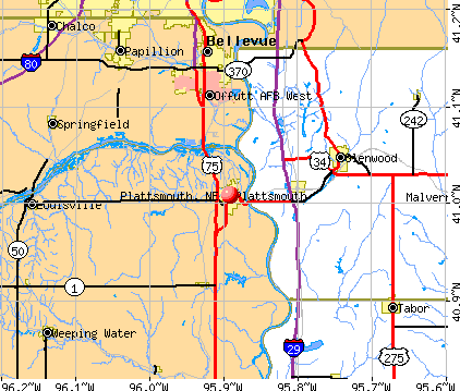
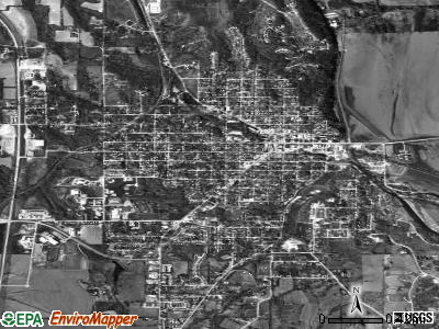
Plattsmouth, Nebraska
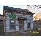
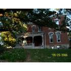
Plattsmouth: log home erected in 1868
Plattsmouth: Plattsmouth Cemetary
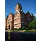
Plattsmouth: Plattsmouth Courthouse
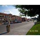
Plattsmouth: Plattsmouth
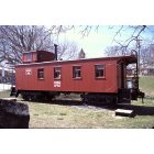
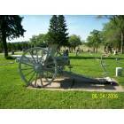
Plattsmouth: CB&Q 13952 railroad caboose display
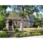
Plattsmouth: Plattsmouth Church
Plattsmouth: Plattsmouth Waldhaus
- add
your
Submit your own pictures of this city and show them to the world
- OSM Map
- General Map
- Google Map
- MSN Map
Population change since 2000: -3.6%
 |
| Males: 3,315 | |
| Females: 3,327 |
| Median resident age: | 37.7 years |
| Nebraska median age: | 37.4 years |
Zip codes: 68048.
| Plattsmouth: | $57,241 |
| NE: | $69,597 |
Estimated per capita income in 2022: $33,535 (it was $17,153 in 2000)
Plattsmouth city income, earnings, and wages data
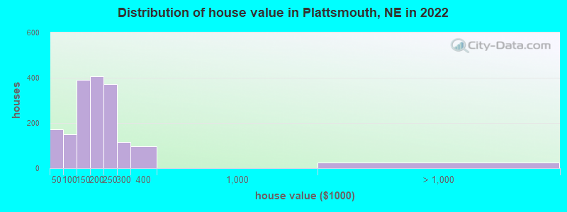
Estimated median house or condo value in 2022: $177,352 (it was $81,000 in 2000)
| Plattsmouth: | $177,352 |
| NE: | $232,400 |
Mean prices in 2022: all housing units: $163,634; detached houses: $168,398; townhouses or other attached units: $178,457; mobile homes: $7,585
Median gross rent in 2022: $961.
(7.6% for White Non-Hispanic residents, 100.0% for Black residents, 10.8% for Hispanic or Latino residents, 68.2% for American Indian residents)
Detailed information about poverty and poor residents in Plattsmouth, NE

Compare current foreclosures near Plattsmouth, NE:
| Photo | Address | Area | Beds / Baths | Price | Details |
|---|---|---|---|---|---|

|
#1
N 7th St
Plattsmouth, NE 68048
|
1,326 sq. feet
|
2 baths 4 beds |
show details | |

|
#2
Mark St
Plattsmouth, NE 68048
|
1,674 sq. feet
|
1 baths 3 beds |
show details | |

|
#3
Cypress Ct
Plattsmouth, NE 68048
|
1,427 sq. feet
|
2 baths 2 beds |
show details | |

|
#4
Dunbar Dr
Plattsmouth, NE 68048
|
1,296 sq. feet
|
2 baths 3 beds |
show details | |

|
#5
N 6th St
Plattsmouth, NE 68048
|
2,477 sq. feet
|
1 baths 3 beds |
show details | |

|
#6
S 15th St Lot 38
Plattsmouth, NE 68048
|
1,344 sq. feet
|
2 baths 3 beds |
show details | |

|
#7
Wallace Dr
Plattsmouth, NE 68048
|
3,776 sq. feet
|
2 baths 3 beds |
show details | |

|
#8
Lake Ridge Dr
Plattsmouth, NE 68048
|
1,639 sq. feet
|
2 baths 3 beds |
show details | |

|
#9
Monroe Rd
Plattsmouth, NE 68048
|
2,254 sq. feet
|
2 baths 3 beds |
show details | |

|
#10
N 9th St
Plattsmouth, NE 68048
|
1,686 sq. feet
|
2 baths 4 beds |
show details |
| Photo | Address | Area | Beds / Baths | Price | Details |
|---|---|---|---|---|---|

|
#11
7th Ave
Plattsmouth, NE 68048
|
1,144 sq. feet
|
2 baths 3 beds |
show details | |

|
#12
Lincoln Ave
Plattsmouth, NE 68048
|
1,440 sq. feet
|
1 baths 3 beds |
show details | |

|
#13
Oakmont Dr
Plattsmouth, NE 68048
|
1,175 sq. feet
|
2 baths 2 beds |
show details | |

|
#14
Gabriella Dr
Plattsmouth, NE 68048
|
1,735 sq. feet
|
3 baths 3 beds |
show details | |

|
#15
S 6th St
Plattsmouth, NE 68048
|
2,259 sq. feet
|
2 baths 3 beds |
show details | |

|
#16
Oakmont Dr
Plattsmouth, NE 68048
|
1,004 sq. feet
|
1 baths 2 beds |
show details | |

|
#17
6th Ave
Plattsmouth, NE 68048
|
- sq. feet
|
- baths - beds |
show details | |

|
#18
S 15th St Lot 26
Plattsmouth, NE 68048
|
- sq. feet
|
- baths - beds |
show details | |

|
#19
N 10th St, Apt 104
Plattsmouth, NE 68048
|
- sq. feet
|
- baths - beds |
show details | |

|
#20
6th St
Plattsmouth, NE 68048
|
- sq. feet
|
- baths - beds |
show details |
| Photo | Address | Area | Beds / Baths | Price | Details |
|---|---|---|---|---|---|

|
#21
Main St
Plattsmouth, NE 68048
|
- sq. feet
|
- baths - beds |
show details | |

|
#22
S 15th St Lot 54
Plattsmouth, NE 68048
|
- sq. feet
|
- baths - beds |
show details | |

|
#23
S 78th Ave
Omaha, NE 68127
|
995 sq. feet
|
1 baths 3 beds |
show details | |

|
#24
Middle Ferry Rd
Council Bluffs, IA 51501
|
1,385 sq. feet
|
2 baths 2 beds |
show details | |

|
#25
E 5th St
Malvern, IA 51551
|
2,205 sq. feet
|
2 baths 2 beds |
show details | |

|
#26
S 36th Ave
Omaha, NE 68107
|
768 sq. feet
|
1 baths 3 beds |
show details | |

|
#27
S 49th St
Omaha, NE 68117
|
1,315 sq. feet
|
2 baths 3 beds |
show details | |

|
#28
South 13th Court
Omaha, NE 68108
|
- sq. feet
|
- baths - beds |
$100,000
|
show details |

|
#29
E Q St
Weeping Water, NE 68463
|
- sq. feet
|
1 baths 3 beds |
show details | |

|
#30
W St
Omaha, NE 68107
|
720 sq. feet
|
1 baths 2 beds |
show details |
| Photo | Address | Area | Beds / Baths | Price | Details |
|---|---|---|---|---|---|

|
#31
S 19th St
Omaha, NE 68107
|
924 sq. feet
|
1 baths 2 beds |
show details | |

|
#32
R St
Omaha, NE 68107
|
2,110 sq. feet
|
2 baths 5 beds |
show details | |

|
#33
Susan Ave
La Vista, NE 68128
|
1,426 sq. feet
|
1 baths 3 beds |
show details | |

|
#34
S 23rd St
Omaha, NE 68107
|
1,946 sq. feet
|
2 baths 3 beds |
show details | |

|
#35
Park View Blvd
La Vista, NE 68128
|
1,822 sq. feet
|
1 baths 3 beds |
show details | |

|
#36
Navajo St
Council Bluffs, IA 51501
|
945 sq. feet
|
1 baths 2 beds |
show details | |

|
#37
S St
Omaha, NE 68107
|
1,148 sq. feet
|
1 baths 4 beds |
show details | |

|
#38
Homer St
Omaha, NE 68107
|
1,424 sq. feet
|
2 baths 3 beds |
show details | |

|
#39
Leaf Plum Dr
La Vista, NE 68128
|
1,368 sq. feet
|
1 baths 3 beds |
show details | |

|
#40
S 51st St
Omaha, NE 68117
|
864 sq. feet
|
1 baths 3 beds |
show details |
| Photo | Address | Area | Beds / Baths | Price | Details |
|---|---|---|---|---|---|

|
#41
Terry Dr
La Vista, NE 68128
|
1,428 sq. feet
|
1 baths 3 beds |
show details | |

|
#42
Norton Dr
Papillion, NE 68046
|
3,470 sq. feet
|
2 baths 4 beds |
show details | |

|
#43
Hickory Ct
La Vista, NE 68128
|
1,762 sq. feet
|
2 baths 3 beds |
show details | |

|
#44
Ramelle Dr
Council Bluffs, IA 51501
|
925 sq. feet
|
1 baths 3 beds |
show details | |

|
#45
Hayes Cir
Omaha, NE 68127
|
1,482 sq. feet
|
3 baths 3 beds |
show details | |

|
#46
S 57th St
Omaha, NE 68117
|
1,622 sq. feet
|
1 baths 3 beds |
show details | |

|
#47
F St
Omaha, NE 68107
|
1,458 sq. feet
|
1 baths 2 beds |
show details | |

|
#48
X St
Omaha, NE 68107
|
1,332 sq. feet
|
1 baths 4 beds |
show details | |

|
#49
Country Club Acres St
Council Bluffs, IA 51501
|
912 sq. feet
|
1 baths 3 beds |
show details | |

|
Check over 1 million property listings on Foreclosure.com!
|
browse all offers | |||


- 5,57184.2%White alone
- 5568.4%Hispanic
- 3505.3%Two or more races
- 1151.7%Other race alone
- 340.5%Asian alone
- 210.3%Black alone
- 50.08%American Indian alone
Races in Plattsmouth detailed stats: ancestries, foreign born residents, place of birth
According to our research of Nebraska and other state lists, there were 33 registered sex offenders living in Plattsmouth, Nebraska as of April 27, 2024.
The ratio of all residents to sex offenders in Plattsmouth is 199 to 1.
Type |
2009 |
2010 |
2011 |
2012 |
2013 |
2014 |
2015 |
2016 |
2017 |
2018 |
2019 |
2020 |
2021 |
2022 |
|---|---|---|---|---|---|---|---|---|---|---|---|---|---|---|
| Murders (per 100,000) | 0 (0.0) | 0 (0.0) | 0 (0.0) | 0 (0.0) | 0 (0.0) | 0 (0.0) | 0 (0.0) | 0 (0.0) | 0 (0.0) | 0 (0.0) | 0 (0.0) | 0 (0.0) | 0 (0.0) | 0 (0.0) |
| Rapes (per 100,000) | 1 (14.5) | 4 (61.5) | 5 (76.2) | 3 (45.9) | 2 (31.1) | 1 (15.5) | 0 (0.0) | 0 (0.0) | 0 (0.0) | 8 (124.1) | 9 (138.9) | 0 (0.0) | 7 (109.2) | 5 (74.5) |
| Robberies (per 100,000) | 0 (0.0) | 0 (0.0) | 0 (0.0) | 1 (15.3) | 0 (0.0) | 1 (15.5) | 0 (0.0) | 0 (0.0) | 0 (0.0) | 1 (15.5) | 0 (0.0) | 1 (15.5) | 0 (0.0) | 1 (14.9) |
| Assaults (per 100,000) | 0 (0.0) | 1 (15.4) | 3 (45.7) | 0 (0.0) | 1 (15.6) | 2 (31.0) | 0 (0.0) | 4 (62.0) | 0 (0.0) | 6 (93.1) | 8 (123.5) | 2 (31.1) | 4 (62.4) | 3 (44.7) |
| Burglaries (per 100,000) | 4 (58.0) | 16 (246.1) | 18 (274.4) | 14 (214.3) | 7 (109.0) | 13 (201.2) | 20 (308.5) | 11 (170.4) | 21 (324.3) | 13 (201.7) | 14 (216.1) | 12 (186.5) | 19 (296.5) | 15 (223.5) |
| Thefts (per 100,000) | 12 (173.9) | 114 (1,753) | 143 (2,180) | 153 (2,342) | 103 (1,604) | 85 (1,316) | 127 (1,959) | 93 (1,441) | 108 (1,668) | 97 (1,505) | 64 (988.0) | 64 (994.6) | 83 (1,295) | 60 (894.2) |
| Auto thefts (per 100,000) | 0 (0.0) | 3 (46.1) | 2 (30.5) | 13 (199.0) | 12 (186.9) | 7 (108.4) | 10 (154.2) | 5 (77.5) | 6 (92.7) | 5 (77.6) | 7 (108.1) | 3 (46.6) | 9 (140.4) | 7 (104.3) |
| Arson (per 100,000) | 2 (29.0) | 1 (15.4) | 1 (15.2) | 1 (15.3) | 0 (0.0) | 3 (46.4) | 1 (15.4) | 1 (15.5) | 0 (0.0) | 0 (0.0) | 0 (0.0) | 0 (0.0) | 0 (0.0) | 0 (0.0) |
| City-Data.com crime index | 22.6 | 143.3 | 179.0 | 165.9 | 114.8 | 98.6 | 112.3 | 88.2 | 96.8 | 203.1 | 199.1 | 67.4 | 183.6 | 132.8 |
The City-Data.com crime index weighs serious crimes and violent crimes more heavily. Higher means more crime, U.S. average is 246.1. It adjusts for the number of visitors and daily workers commuting into cities.
Crime rate in Plattsmouth detailed stats: murders, rapes, robberies, assaults, burglaries, thefts, arson
Full-time law enforcement employees in 2021, including police officers: 17 (14 officers - 12 male; 2 female).
| Officers per 1,000 residents here: | 2.18 |
| US average: | 2.38 |
 Recent articles from our blog. Our writers, many of them Ph.D. graduates or candidates, create easy-to-read articles on a wide variety of topics.

 | Moving to Omaha (22 replies) |
| Hows the flooding? (6 replies) |
| What is desirable little town in NE? (11 replies) |
| Plattsmouth/Murray-Beaver Lake Area? (9 replies) |
| Dog Parks in Omaha near Plattsmouth, Sarpy, Cass and Douglas County (1 reply) |
| I'd like to start a not-for-profit for Housing Needs in Plattsmouth, NE (0 replies) |
Latest news from Plattsmouth, NE collected exclusively by city-data.com from local newspapers, TV, and radio stations
Ancestries: German (21.4%), Irish (9.1%), American (8.9%), Italian (7.8%), English (7.3%), Czech (4.5%).
Current Local Time: CST time zone
Incorporated on 03/15/1855
Elevation: 980 feet
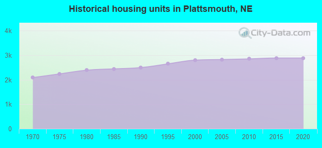
Land area: 2.89 square miles.
Population density: 2,297 people per square mile (low).
100 residents are foreign born
| This city: | 1.5% |
| Nebraska: | 7.5% |
Median real estate property taxes paid for housing units with mortgages in 2022: $2,742 (1.4%)
Median real estate property taxes paid for housing units with no mortgage in 2022: $2,732 (1.8%)
Nearest city with pop. 50,000+: Council Bluffs, IA  (17.0 miles , pop. 58,268).
Nearest city with pop. 200,000+: Omaha, NE (18.5 miles , pop. 390,007).
Nearest city with pop. 1,000,000+: Chicago, IL (429.6 miles , pop. 2,896,016).
Nearest cities:
Latitude: 41.01 N, Longitude: 95.89 W
Daytime population change due to commuting: -1,580 (-23.9%)
Workers who live and work in this city: 888 (25.6%)
Area code: 402
Plattsmouth, Nebraska accommodation & food services, waste management - Economy and Business Data
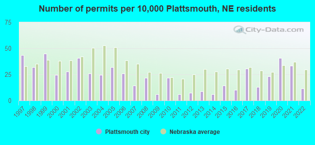
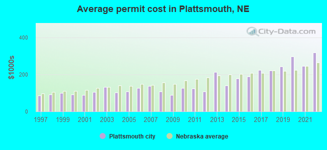
Single-family new house construction building permits:
- 2022: 8 buildings, average cost: $318,100
- 2021: 23 buildings, average cost: $246,100
- 2020: 28 buildings, average cost: $296,000
- 2019: 16 buildings, average cost: $242,200
- 2018: 9 buildings, average cost: $220,600
- 2017: 21 buildings, average cost: $222,700
- 2016: 7 buildings, average cost: $188,700
- 2015: 10 buildings, average cost: $178,000
- 2014: 4 buildings, average cost: $139,500
- 2013: 6 buildings, average cost: $212,000
- 2012: 5 buildings, average cost: $107,800
- 2011: 4 buildings, average cost: $122,500
- 2010: 15 buildings, average cost: $128,000
- 2009: 4 buildings, average cost: $89,300
- 2008: 15 buildings, average cost: $107,400
- 2007: 10 buildings, average cost: $136,700
- 2006: 18 buildings, average cost: $127,100
- 2005: 22 buildings, average cost: $108,800
- 2004: 17 buildings, average cost: $103,100
- 2003: 18 buildings, average cost: $131,300
- 2002: 28 buildings, average cost: $104,200
- 2001: 19 buildings, average cost: $90,200
- 2000: 17 buildings, average cost: $92,300
- 1999: 31 buildings, average cost: $99,600
- 1998: 22 buildings, average cost: $91,100
- 1997: 30 buildings, average cost: $84,500
| Here: | 2.2% |
| Nebraska: | 2.2% |
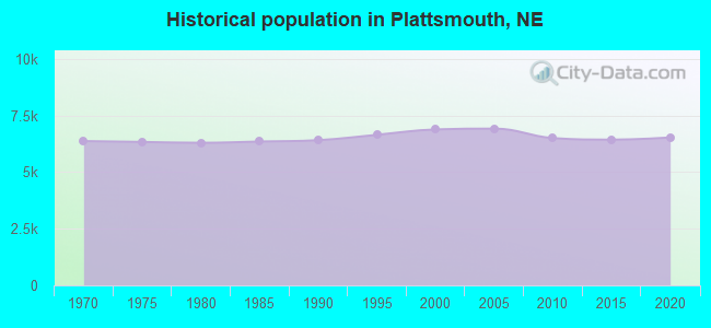
Population change in the 1990s: +180 (+2.7%).
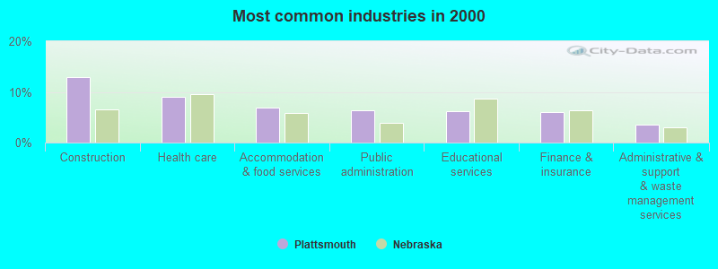
- Construction (13.0%)
- Health care (9.1%)
- Accommodation & food services (6.9%)
- Public administration (6.4%)
- Educational services (6.1%)
- Finance & insurance (6.0%)
- Administrative & support & waste management services (3.5%)
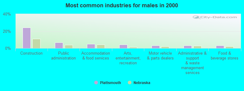
- Construction (24.2%)
- Public administration (6.5%)
- Accommodation & food services (4.9%)
- Arts, entertainment, recreation (4.2%)
- Motor vehicle & parts dealers (3.3%)
- Administrative & support & waste management services (3.3%)
- Food & beverage stores (3.3%)
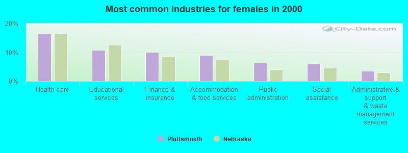
- Health care (16.5%)
- Educational services (10.8%)
- Finance & insurance (10.2%)
- Accommodation & food services (9.0%)
- Public administration (6.3%)
- Social assistance (6.0%)
- Administrative & support & waste management services (3.6%)
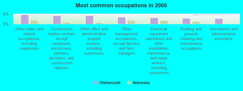
- Other sales and related occupations, including supervisors (5.7%)
- Construction traders workers except carpenters, electricians, painters, plumbers, and construction laborers (5.1%)
- Other office and administrative support workers, including supervisors (5.0%)
- Other management occupations, except farmers and farm managers (4.2%)
- Electrical equipment mechanics and other installation, maintenance, and repair workers, including supervisors (3.8%)
- Building and grounds cleaning and maintenance occupations (3.4%)
- Secretaries and administrative assistants (3.3%)
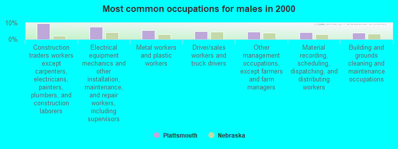
- Construction traders workers except carpenters, electricians, painters, plumbers, and construction laborers (9.8%)
- Electrical equipment mechanics and other installation, maintenance, and repair workers, including supervisors (7.4%)
- Metal workers and plastic workers (5.4%)
- Driver/sales workers and truck drivers (4.7%)
- Other management occupations, except farmers and farm managers (4.7%)
- Material recording, scheduling, dispatching, and distributing workers (4.3%)
- Building and grounds cleaning and maintenance occupations (4.0%)
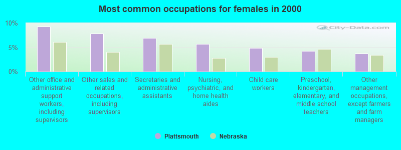
- Other office and administrative support workers, including supervisors (9.3%)
- Other sales and related occupations, including supervisors (7.9%)
- Secretaries and administrative assistants (6.9%)
- Nursing, psychiatric, and home health aides (5.7%)
- Child care workers (4.8%)
- Preschool, kindergarten, elementary, and middle school teachers (4.2%)
- Other management occupations, except farmers and farm managers (3.7%)
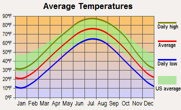
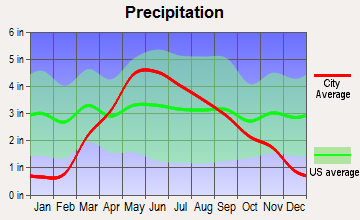
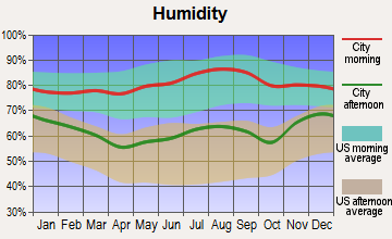
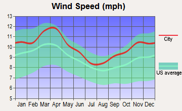
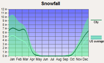
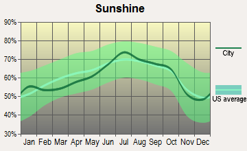
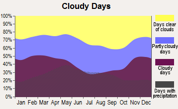
Average climate in Plattsmouth, Nebraska
Based on data reported by over 4,000 weather stations
|
|


(lower is better)
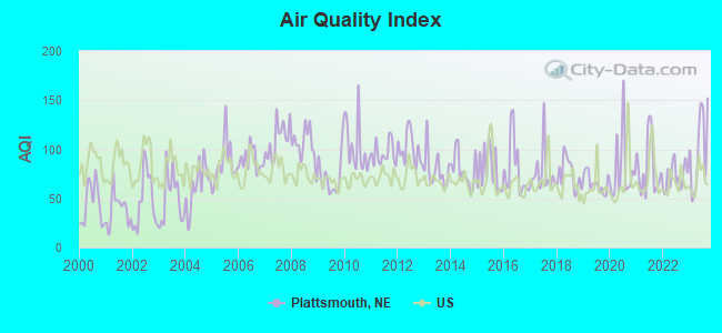
Air Quality Index (AQI) level in 2023 was 99.8. This is worse than average.
| City: | 99.8 |
| U.S.: | 72.6 |
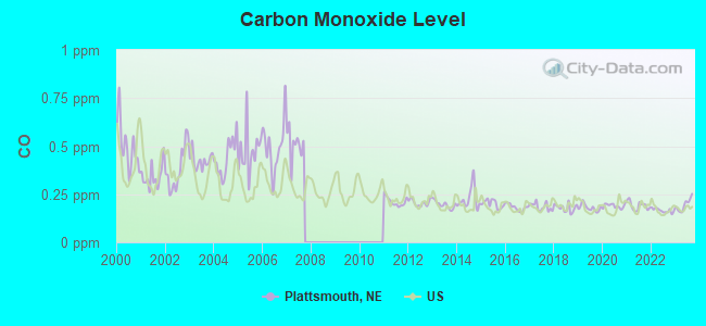
Carbon Monoxide (CO) [ppm] level in 2023 was 0.195. This is better than average. Closest monitor was 17.1 miles away from the city center.
| City: | 0.195 |
| U.S.: | 0.251 |

Sulfur Dioxide (SO2) [ppb] level in 2023 was 0.437. This is significantly better than average. Closest monitor was 8.9 miles away from the city center.
| City: | 0.437 |
| U.S.: | 1.515 |
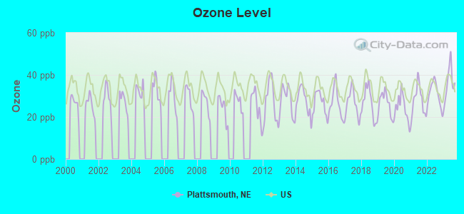
Ozone [ppb] level in 2023 was 36.2. This is about average. Closest monitor was 14.1 miles away from the city center.
| City: | 36.2 |
| U.S.: | 33.3 |
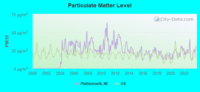
Particulate Matter (PM10) [µg/m3] level in 2023 was 21.3. This is about average. Closest monitor was 13.7 miles away from the city center.
| City: | 21.3 |
| U.S.: | 19.2 |
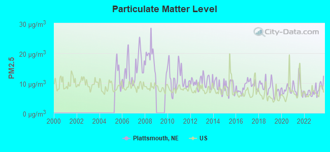
Particulate Matter (PM2.5) [µg/m3] level in 2023 was 8.85. This is about average. Closest monitor was 9.3 miles away from the city center.
| City: | 8.85 |
| U.S.: | 8.11 |
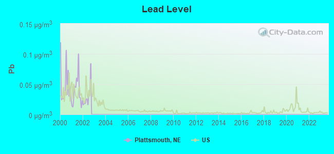
Lead (Pb) [µg/m3] level in 2002 was 0.0298. This is significantly worse than average. Closest monitor was 11.1 miles away from the city center.
| City: | 0.0298 |
| U.S.: | 0.0093 |
Tornado activity:
Plattsmouth-area historical tornado activity is slightly above Nebraska state average. It is 97% greater than the overall U.S. average.
On 4/25/1957, a category F4 (max. wind speeds 207-260 mph) tornado 13.9 miles away from the Plattsmouth city center killed one person and injured 8 people and caused between $500,000 and $5,000,000 in damages.
On 5/6/1975, a category F4 tornado 14.5 miles away from the city center killed 3 people and injured 133 people and caused between $50,000 and $500,000 in damages.
Earthquake activity:
Plattsmouth-area historical earthquake activity is significantly above Nebraska state average. It is 332% greater than the overall U.S. average.On 9/3/2016 at 12:02:44, a magnitude 5.8 (5.8 MW, Depth: 3.5 mi, Class: Moderate, Intensity: VI - VII) earthquake occurred 321.9 miles away from Plattsmouth center
On 11/6/2011 at 03:53:10, a magnitude 5.7 (5.7 MW, Depth: 3.2 mi) earthquake occurred 381.8 miles away from Plattsmouth center
On 11/12/2014 at 21:40:00, a magnitude 4.9 (4.9 MW, Depth: 2.5 mi, Class: Light, Intensity: IV - V) earthquake occurred 274.6 miles away from Plattsmouth center
On 6/22/2019 at 08:50:24, a magnitude 4.6 (4.6 MW, Depth: 1.9 mi) earthquake occurred 224.3 miles away from Plattsmouth center
On 12/17/2009 at 02:53:42, a magnitude 3.6 (3.6 MB, Depth: 3.1 mi, Class: Light, Intensity: II - III) earthquake occurred 41.7 miles away from Plattsmouth center
On 7/16/2004 at 12:17:30, a magnitude 3.5 (3.5 MW, Depth: 3.1 mi) earthquake occurred 31.6 miles away from the city center
Magnitude types: body-wave magnitude (MB), moment magnitude (MW)
Natural disasters:
The number of natural disasters in Cass County (21) is greater than the US average (15).Major Disasters (Presidential) Declared: 16
Emergencies Declared: 2
Causes of natural disasters: Floods: 16, Storms: 14, Tornadoes: 9, Winds: 5, Snows: 2, Winter Storms: 2, Hurricane: 1, Snowstorm: 1, Other: 1 (Note: some incidents may be assigned to more than one category).

Hospitals and medical centers in Plattsmouth:
Other hospitals and medical centers near Plattsmouth:
- PACIFIC PLACE (Hospital, about 7 miles away; PACIFIC JUNCTION, IA)
- GLENWOOD RESOURCE CENTER (Hospital, about 9 miles away; GLENWOOD, IA)
- MILLS COUNTY PHNS (Home Health Center, about 9 miles away; GLENWOOD, IA)
- ON WITH LIFE AT GLENWOOD (Nursing Home, about 9 miles away; GLENWOOD, IA)
- HILLSIDE MANOR CORP (Nursing Home, about 9 miles away; GLENWOOD, IA)
- HILLCREST HEALTH AND REHAB (Nursing Home, about 10 miles away; BELLEVUE, NE)
- HILLCREST HOME CARE (Home Health Center, about 10 miles away; BELLEVUE, NE)
Airports located in Plattsmouth:
- Plattsmouth Municipal Airport (PMV) (Runways: 1, Air Taxi Ops: 200, Itinerant Ops: 10,500, Local Ops: 9,700, Military Ops: 100)
Colleges/universities with over 2000 students nearest to Plattsmouth:
- Bellevue University (about 10 miles; Bellevue, NE; Full-time enrollment: 7,139)
- University of Nebraska Medical Center (about 18 miles; Omaha, NE; FT enrollment: 2,815)
- Creighton University (about 18 miles; Omaha, NE; FT enrollment: 5,370)
- University of Nebraska at Omaha (about 19 miles; Omaha, NE; FT enrollment: 12,073)
- Iowa Western Community College (about 19 miles; Council Bluffs, IA; FT enrollment: 5,344)
- Metropolitan Community College Area (about 21 miles; Omaha, NE; FT enrollment: 12,236)
- Southeast Community College Area (about 41 miles; Lincoln, NE; FT enrollment: 8,838)
Public high school in Plattsmouth:
- PLATTSMOUTH HIGH SCHOOL (Location: 1916 E HWY 34, Grades: 9-12)
Public elementary/middle schools in Plattsmouth:
- PLATTSMOUTH ELEMENTARY SCHOOL (Location: 1724 8TH AVE, Grades: PK-4)
- PLATTSMOUTH MIDDLE SCHOOL (Location: 1724 8TH AVE, Grades: 5-8)
Private elementary/middle school in Plattsmouth:
Library in Plattsmouth:
Points of interest:
Notable locations in Plattsmouth: Plattsmouth (A), Cass County Courthouse (B), Cass County Sheriffs Office (C), Plattsmouth Police Department (D), Plattsmouth Volunteer Fire Department (E), Cass County Historical Museum (F), Plattsmouth Public Library (G), Plattsmouth Volunteer Rescue Squad (H). Display/hide their locations on the map
Churches in Plattsmouth include: New Hope Community Church (A), Kingdom Hall of Jehovahs Witnesses (B), First Presbyterian Church (C), Church of Christ (D), Hosanna Lutheran Church (E), Church of the Holy Spirit (F), Plattsmouth Baptist Church (G), Wesleyan Church (H), Faith Alliance Church (I). Display/hide their locations on the map
Cemetery: Oak Hill Cemetery (1). Display/hide its location on the map
Reservoirs: Plattsmouth Reservoir 12-A (A), Plattsmouth Reservoir 10-A (B). Display/hide their locations on the map
Parks in Plattsmouth include: Garfield Park (1), Rhylander Park (2), Memorial Park (3), Company A - First Nebraska Infantry Historical Marker (4). Display/hide their locations on the map
Tourist attractions: Westroads Medical Group (Cultural Attractions- Events- & Facilities; 1938 East Highway 34), Hervey's Coin Op (Amusement & Theme Parks; 119 North 6th Street), Cass County Visiters Promotion (918 Washington Avenue).
Birthplace of: Hazel Abel - Politician.
Drinking water stations with addresses in Plattsmouth and their reported violations in the past:
CASS CO SID 7 - SWALLOW HILL (Population served: 59, Purch groundwater):Past monitoring violations:
- One routine major monitoring violation
Drinking water stations with addresses in Plattsmouth that have no violations reported:
- PLATTSMOUTH, CITY OF (Population served: 6,502, Primary Water Source Type: Groundwater)
- BEAVER LAKE ASSOCIATION INC (Population served: 2,790, Primary Water Source Type: Surface water)
- CASS CO SID 5 - BUCCANEER BAY (Population served: 882, Primary Water Source Type: Groundwater)
- SARPY CO SID 97 - HAWAIIAN VILLAGE (Population served: 489, Primary Water Source Type: Groundwater)
| This city: | 2.5 people |
| Nebraska: | 2.5 people |
| This city: | 64.2% |
| Whole state: | 64.8% |
| This city: | 7.2% |
| Whole state: | 6.0% |
Likely homosexual households (counted as self-reported same-sex unmarried-partner households)
- Lesbian couples: 0.2% of all households
- Gay men: 0.2% of all households
People in group quarters in Plattsmouth in 2010:
- 133 people in nursing facilities/skilled-nursing facilities
- 90 people in local jails and other municipal confinement facilities
- 5 people in group homes intended for adults
5 people in homes for the mentally retarded in 2000
Banks with branches in Plattsmouth (2011 data):
- Plattsmouth State Bank: Drive-In Branch, Drive-In Branch, at 446 Main Street. Info updated 2006/11/03: Bank assets: $78.9 mil, Deposits: $65.1 mil, local headquarters, positive income, 3 total offices, Holding Company: Schneider Bancorporation
- Cass County Bank, Inc.: at 2020 West Holdrege Street, branch established on 1966/11/08; Downtown Branch at Sixth And Main Streets, branch established on 1975/01/25. Info updated 2010/06/21: Bank assets: $48.5 mil, Deposits: $42.5 mil, local headquarters, positive income, Commercial Lending Specialization, 2 total offices, Holding Company: Cass County State Company
- American National Bank: Plattsmouth Branch at 602 Avenue A, branch established on 1934/09/01. Info updated 2012/02/13: Bank assets: $1,928.1 mil, Deposits: $1,460.0 mil, headquarters in Omaha, NE, positive income, Commercial Lending Specialization, 34 total offices, Holding Company: American National Corporation
For population 15 years and over in Plattsmouth:
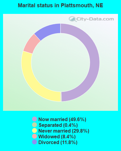
- Never married: 29.8%
- Now married: 49.6%
- Separated: 0.4%
- Widowed: 8.4%
- Divorced: 11.8%
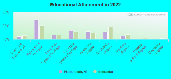
For population 25 years and over in Plattsmouth:
- High school or higher: 93.8%
- Bachelor's degree or higher: 19.8%
- Graduate or professional degree: 6.9%
- Unemployed: 3.6%
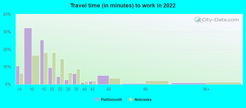
- Mean travel time to work (commute): 25.5 minutes
| Here: | 8.4 |
| Nebraska average: | 11.2 |
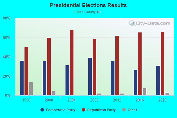
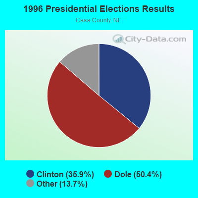
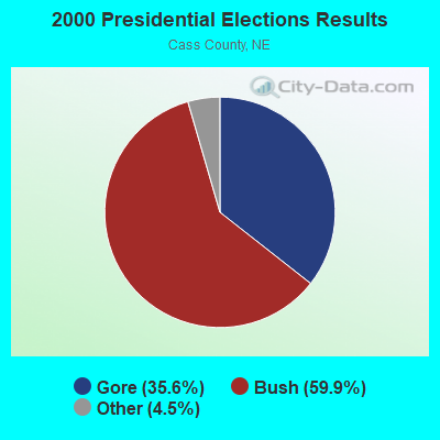
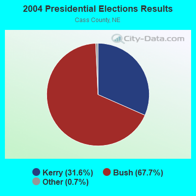

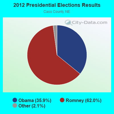
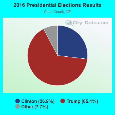
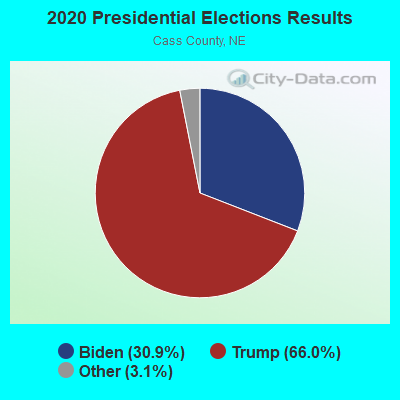
Graphs represent county-level data. Detailed 2008 Election Results
Religion statistics for Plattsmouth, NE (based on Cass County data)
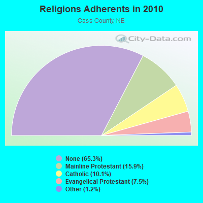
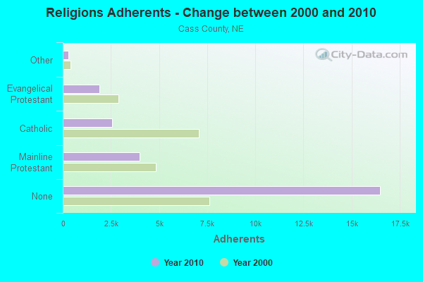
| Religion | Adherents | Congregations |
|---|---|---|
| Mainline Protestant | 4,007 | 25 |
| Catholic | 2,557 | 4 |
| Evangelical Protestant | 1,886 | 13 |
| Other | 302 | 2 |
| None | 16,489 | - |
Food Environment Statistics:
| Here: | 1.96 / 10,000 pop. |
| Nebraska: | 2.60 / 10,000 pop. |
| This county: | 0.78 / 10,000 pop. |
| Nebraska: | 0.44 / 10,000 pop. |
| Cass County: | 6.28 / 10,000 pop. |
| Nebraska: | 4.83 / 10,000 pop. |
| Cass County: | 5.49 / 10,000 pop. |
| Nebraska: | 7.76 / 10,000 pop. |
| Cass County: | 7.8% |
| Nebraska: | 7.9% |
| This county: | 26.5% |
| Nebraska: | 28.0% |
| Here: | 11.6% |
| Nebraska: | 12.9% |
Health and Nutrition:
| Plattsmouth: | 49.3% |
| State: | 48.9% |
| Plattsmouth: | 46.8% |
| Nebraska: | 45.5% |
| This city: | 28.9 |
| Nebraska: | 28.6 |
| Plattsmouth: | 21.0% |
| Nebraska: | 21.4% |
| Here: | 9.6% |
| Nebraska: | 10.5% |
| Plattsmouth: | 6.8 |
| State: | 6.8 |
| Here: | 35.2% |
| State: | 33.5% |
| This city: | 56.8% |
| Nebraska: | 55.6% |
| Plattsmouth: | 78.7% |
| Nebraska: | 78.2% |
More about Health and Nutrition of Plattsmouth, NE Residents
| Local government employment and payroll (March 2022) | |||||
| Function | Full-time employees | Monthly full-time payroll | Average yearly full-time wage | Part-time employees | Monthly part-time payroll |
|---|---|---|---|---|---|
| Police Protection - Officers | 15 | $90,283 | $72,226 | 2 | $496 |
| Streets and Highways | 6 | $28,977 | $57,954 | 0 | $0 |
| Parks and Recreation | 5 | $19,223 | $46,135 | 23 | $7,979 |
| Health | 5 | $25,347 | $60,833 | 19 | $32,596 |
| Other Government Administration | 4 | $23,971 | $71,913 | 0 | $0 |
| Financial Administration | 4 | $20,118 | $60,354 | 0 | $0 |
| Local Libraries | 4 | $14,177 | $42,531 | 5 | $3,693 |
| Water Supply | 4 | $22,568 | $67,704 | 0 | $0 |
| Police - Other | 3 | $12,194 | $48,776 | 0 | $0 |
| Sewerage | 1 | $4,578 | $54,936 | 0 | $0 |
| Welfare | 1 | $2,572 | $30,864 | 3 | $3,652 |
| Totals for Government | 52 | $264,008 | $60,925 | 52 | $48,417 |
Plattsmouth government finances - Expenditure in 2018 (per resident):
- Construction - Regular Highways: $1,503,000 ($226.29)
Water Utilities: $435,000 ($65.49)
- Current Operations - Parks and Recreation: $983,000 ($148.00)
Police Protection: $960,000 ($144.53)
Gas Utilities: $913,000 ($137.46)
Regular Highways: $866,000 ($130.38)
Housing and Community Development: $833,000 ($125.41)
Water Utilities: $690,000 ($103.88)
Local Fire Protection: $614,000 ($92.44)
Protective Inspection and Regulation - Other: $456,000 ($68.65)
Central Staff Services: $402,000 ($60.52)
Libraries: $328,000 ($49.38)
Financial Administration: $309,000 ($46.52)
General Public Buildings: $62,000 ($9.33)
Public Welfare - Other: $43,000 ($6.47)
Health - Other: $30,000 ($4.52)
- General - Interest on Debt: $467,000 ($70.31)
- Other Capital Outlay - Regular Highways: $51,000 ($7.68)
Parks and Recreation: $38,000 ($5.72)
Libraries: $13,000 ($1.96)
Police Protection: $11,000 ($1.66)
Local Fire Protection: $7,000 ($1.05)
- Total Salaries and Wages: $3,520,000 ($529.96)
Plattsmouth government finances - Revenue in 2018 (per resident):
- Charges - Other: $856,000 ($128.88)
Parks and Recreation: $216,000 ($32.52)
- Federal Intergovernmental - Other: $313,000 ($47.12)
- Local Intergovernmental - General Local Government Support: $85,000 ($12.80)
- Miscellaneous - General Revenue - Other: $655,000 ($98.61)
Interest Earnings: $64,000 ($9.64)
- Revenue - Gas Utilities: $1,069,000 ($160.95)
Water Utilities: $1,035,000 ($155.83)
- State Intergovernmental - Highways: $587,000 ($88.38)
General Local Government Support: $457,000 ($68.80)
Other: $41,000 ($6.17)
- Tax - Property: $1,533,000 ($230.80)
General Sales and Gross Receipts: $1,185,000 ($178.41)
Other License: $958,000 ($144.23)
Public Utilities Sales: $252,000 ($37.94)
Plattsmouth government finances - Debt in 2018 (per resident):
- Long Term Debt - Beginning Outstanding - Unspecified Public Purpose: $11,780,000 ($1773.56)
Outstanding Unspecified Public Purpose: $11,675,000 ($1757.75)
Retired Unspecified Public Purpose: $1,343,000 ($202.20)
Issue, Unspecified Public Purpose: $1,238,000 ($186.39)
Plattsmouth government finances - Cash and Securities in 2018 (per resident):
- Other Funds - Cash and Securities: $3,209,000 ($483.14)
| Businesses in Plattsmouth, NE | ||||
| Name | Count | Name | Count | |
|---|---|---|---|---|
| Burger King | 1 | KFC | 1 | |
| Chevrolet | 1 | Pizza Hut | 1 | |
| Curves | 1 | Subway | 1 | |
| Dairy Queen | 1 | Taco Bell | 1 | |
| FedEx | 1 | U-Haul | 1 | |
| Ford | 1 | UPS | 2 | |
| H&R Block | 1 | |||
Strongest AM radio stations in Plattsmouth:
- KOIL (1020 AM; 50 kW; PLATTSMOUTH, NE; Owner: WAITT RADIO, INC.)
- KFAB (1110 AM; 50 kW; OMAHA, NE; Owner: CAPSTAR TX LIMITED PARTNERSHIP)
- KKAR (1290 AM; 50 kW; OMAHA, NE; Owner: WAITT RADIO, INC.)
- KYDZ (1180 AM; 25 kW; BELLEVUE, NE; Owner: WAITT RADIO, INC.)
- KLNG (1560 AM; daytime; 10 kW; COUNCIL BLUFFS, IA)
- KOZN (1620 AM; 10 kW; BELLEVUE, NE; Owner: WAITT RADIO, INC.)
- KOMJ (590 AM; 5 kW; OMAHA, NE; Owner: JOURNAL BROADCAST CORPORATION)
- KMA (960 AM; 5 kW; SHENANDOAH, IA; Owner: KMA BROADCASTING L.P.)
- KHLP (1420 AM; 1 kW; OMAHA, NE; Owner: JOURNAL BROADCAST CORPORATION)
- WHB (810 AM; 50 kW; KANSAS CITY, MO; Owner: UNION BROADCASTING, INC.)
- KCRO (660 AM; 1 kW; OMAHA, NE; Owner: ETERNAL BROADCASTING, LLC)
- KYFR (920 AM; 5 kW; SHENANDOAH, IA; Owner: FAMILY STATIONS, INC.)
- KOSR (1490 AM; 1 kW; OMAHA, NE; Owner: JOURNAL BROADCAST CORPORATION)
Strongest FM radio stations in Plattsmouth:
- KCTY-FM (106.9 FM; PLATTSMOUTH, NE; Owner: PLATTE BROADCASTING COMPANY, INC.)
- KEFM (96.1 FM; OMAHA, NE; Owner: WEBSTER COMMUNICATIONS CO.)
- KLTQ (101.9 FM; LINCOLN, NE; Owner: WAITT RADIO, INC.)
- KGBI-FM (100.7 FM; OMAHA, NE; Owner: GRACE UNIVERSITY)
- KBBX-FM (97.7 FM; NEBRASKA CITY, NE; Owner: JOURNAL BROADCAST CORPORATION)
- KMLV (88.1 FM; RALSTON, NE; Owner: EDUCATIONAL MEDIA FOUNDATION)
- KGOR (99.9 FM; OMAHA, NE; Owner: CAPSTAR TX LIMITED PARTNERSHIP)
- KQCH (94.1 FM; OMAHA, NE; Owner: JOURNAL BROADCAST CORPORATION)
- KEZO-FM (92.3 FM; OMAHA, NE; Owner: JOURNAL BROADCAST CORPORATION)
- KQKQ-FM (98.5 FM; COUNCIL BLUFFS, IA; Owner: WAITT RADIO, INC.)
- KSRZ (104.5 FM; OMAHA, NE; Owner: JOURNAL BROADCAST CORPORATION)
- KIWR (89.7 FM; COUNCIL BLUFFS, IA; Owner: IOWA WESTERN COMMUNITY COLLEGE)
- KFRX (102.7 FM; LINCOLN, NE; Owner: THREE EAGLES OF LINCOLN, INC.)
- KXKT (103.7 FM; GLENWOOD, IA; Owner: CAPSTAR TX LIMITED PARTNERSHIP)
- KVNO (90.7 FM; OMAHA, NE; Owner: THE BOARD OF REGENTS OF UNIV. OF NEBRASKA)
- KIOS-FM (91.5 FM; OMAHA, NE; Owner: DOUGLAS COUNTY SCHOOL DISTRICT 001)
- K299AK (107.7 FM; OMAHA, NE; Owner: BAER COMMUNICATIONS, INC.)
- KKCD (105.9 FM; OMAHA, NE; Owner: JOURNAL BROADCAST CORPORATION)
- KVSS (88.9 FM; OMAHA, NE; Owner: VSS CATHOLIC COMMUNICATIONS, INC.)
- KRQC (93.3 FM; BENNINGTON, NE; Owner: CAPSTAR TX LIMITED PARTNERSHIP)
TV broadcast stations around Plattsmouth:
- KPTM (Channel 42; OMAHA, NE; Owner: PAPPAS TELECASTING OF THE MIDLANDS)
- KXVO (Channel 15; OMAHA, NE; Owner: MITTS TELECASTING COMPANY)
- KYNE-TV (Channel 26; OMAHA, NE; Owner: NEBRASKA EDUCATIONAL TELECOMMUNICATIONS COMM.)
- KMTV (Channel 3; OMAHA, NE; Owner: EMMIS TELEVISION LICENSE CORPORATION)
- KETV (Channel 7; OMAHA, NE; Owner: KETV HEARST-ARGYLE TELEVISION, INC.)
- WOWT-TV (Channel 6; OMAHA, NE; Owner: GRAY MIDAMERICA TV LICENSEE CORP.)
- KUON-TV (Channel 12; LINCOLN, NE; Owner: THE UNIVERSITY OF NEBRASKA)
- KVSS-LP (Channel 67; OMAHA, NE; Owner: VSS CATHOLIC COMMUNICATIONS)
- KHIN (Channel 36; RED OAK, IA; Owner: IOWA PUBLIC BROADCASTING BOARD)
- K61GA (Channel 61; OMAHA, NE; Owner: THREE ANGELS BROADCASTING NETWORK)
- KLKN (Channel 8; LINCOLN, NE; Owner: CITADEL COMMUNICATIONS, L.L.C.)
- K21ES (Channel 21; COLUMBUS, ETC, NE; Owner: DAVID C. BRODAHL)
- KKAZ-CA (Channel 24; OMAHA, NE; Owner: PAPPAS TELECASTING OF THE MIDLANDS)
- K53EY (Channel 53; OMAHA, NE; Owner: TV-45, INC.)
- National Bridge Inventory (NBI) Statistics
- 24Number of bridges
- 338ft / 103mTotal length
- 47,205Total average daily traffic
- 3,461Total average daily truck traffic
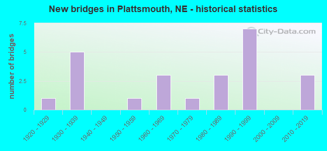
- New bridges - historical statistics
- 11920-1929
- 51930-1939
- 11950-1959
- 31960-1969
- 11970-1979
- 31980-1989
- 71990-1999
- 32010-2019
FCC Registered Antenna Towers: 51 (See the full list of FCC Registered Antenna Towers)
FCC Registered Private Land Mobile Towers: 2 (See the full list of FCC Registered Private Land Mobile Towers in Plattsmouth, NE)
FCC Registered Broadcast Land Mobile Towers: 19 (See the full list of FCC Registered Broadcast Land Mobile Towers)
FCC Registered Microwave Towers: 25 (See the full list of FCC Registered Microwave Towers in this town)
FCC Registered Paging Towers: 2 (See the full list of FCC Registered Paging Towers)
FCC Registered Maritime Coast & Aviation Ground Towers: 4 (See the full list of FCC Registered Maritime Coast & Aviation Ground Towers)
FCC Registered Amateur Radio Licenses: 88 (See the full list of FCC Registered Amateur Radio Licenses in Plattsmouth)
FAA Registered Aircraft: 19 (See the full list of FAA Registered Aircraft in Plattsmouth)
2002 - 2018 National Fire Incident Reporting System (NFIRS) incidents
- Fire incident types reported to NFIRS in Plattsmouth, NE
- 22245.9%Structure Fires
- 18638.4%Outside Fires
- 6313.0%Mobile Property/Vehicle Fires
- 132.7%Other
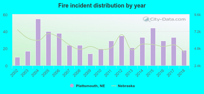 Based on the data from the years 2002 - 2018 the average number of fire incidents per year is 28. The highest number of reported fire incidents - 55 took place in 2004, and the least - 10 in 2002. The data has a rising trend.
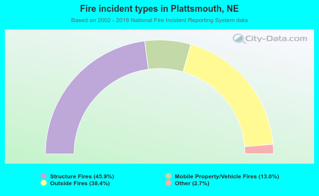 When looking into fire subcategories, the most reports belonged to: Structure Fires (45.9%), and Outside Fires (38.4%).
| Most common first names in Plattsmouth, NE among deceased individuals | ||
| Name | Count | Lived (average) |
|---|---|---|
| Mary | 72 | 77.2 years |
| John | 67 | 79.3 years |
| William | 58 | 77.2 years |
| Robert | 54 | 71.8 years |
| James | 48 | 74.9 years |
| George | 40 | 81.4 years |
| Helen | 39 | 81.8 years |
| Charles | 35 | 75.2 years |
| Anna | 32 | 83.5 years |
| Ruth | 30 | 84.0 years |
| Most common last names in Plattsmouth, NE among deceased individuals | ||
| Last name | Count | Lived (average) |
|---|---|---|
| Meisinger | 40 | 81.1 years |
| Smith | 24 | 81.8 years |
| Wiles | 23 | 84.1 years |
| Taylor | 20 | 80.0 years |
| Hild | 14 | 83.9 years |
| Jones | 14 | 80.5 years |
| Campbell | 13 | 74.5 years |
| Kaffenberger | 13 | 78.2 years |
| Clark | 12 | 75.2 years |
| Johnson | 12 | 79.1 years |
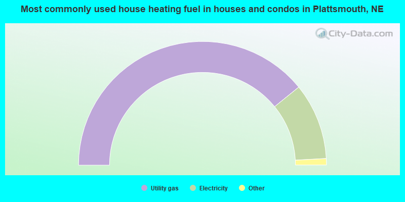
- 78.3%Utility gas
- 20.0%Electricity
- 1.0%Other fuel
- 0.7%No fuel used
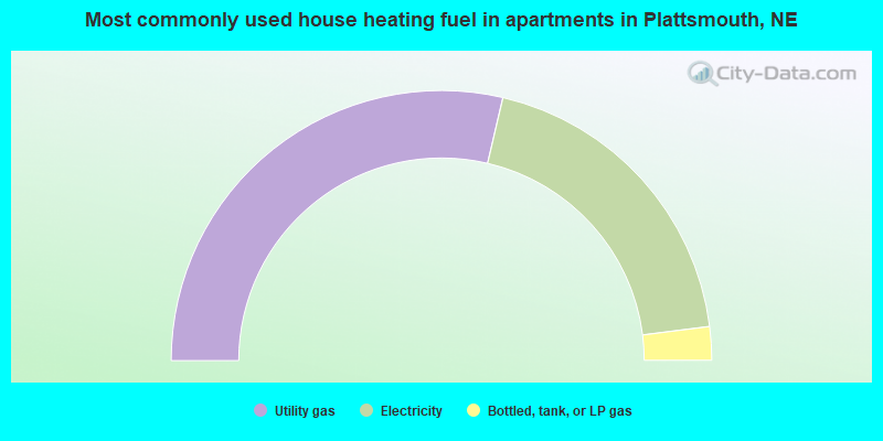
- 57.3%Utility gas
- 38.7%Electricity
- 4.0%Bottled, tank, or LP gas
Plattsmouth compared to Nebraska state average:
- Unemployed percentage significantly below state average.
- Black race population percentage significantly below state average.
- Median age below state average.
- Foreign-born population percentage significantly below state average.
- Length of stay since moving in significantly above state average.
- Institutionalized population percentage above state average.
Plattsmouth on our top lists:
- #3 on the list of "Top 101 cities with the lowest number of assaults per 100,000 residents (population 5,000+)"
- #48 on the list of "Top 101 counties with the highest Particulate Matter (PM10) Annual air pollution readings in 2012 (µg/m3)"

|
|
Total of 16 patent applications in 2008-2024.