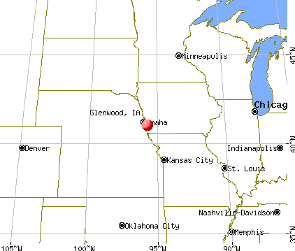
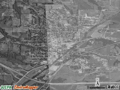
Glenwood, Iowa

Glenwood: The sun partiallly behind trees in Glenwood IA
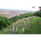
Glenwood: Yucca in Bloom

Glenwood: Glenwood Lake Park

Glenwood: Pony Creek Lake
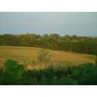
Glenwood: The country part of Glenwood IA
- add
your
Submit your own pictures of this city and show them to the world
- OSM Map
- General Map
- Google Map
- MSN Map
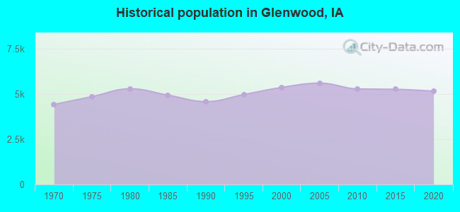
Population change since 2000: -4.1%
 |
| Males: 2,348 | |
| Females: 2,788 |
| Median resident age: | 44.4 years |
| Iowa median age: | 38.9 years |
Zip codes: 51534.
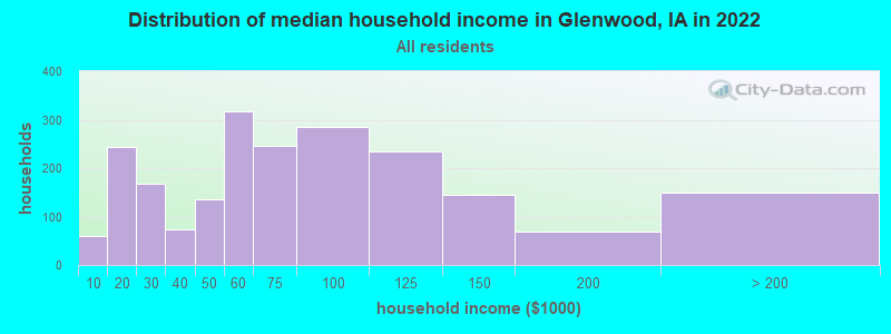
| Glenwood: | $64,916 |
| IA: | $69,588 |
Estimated per capita income in 2022: $40,375 (it was $15,790 in 2000)
Glenwood city income, earnings, and wages data
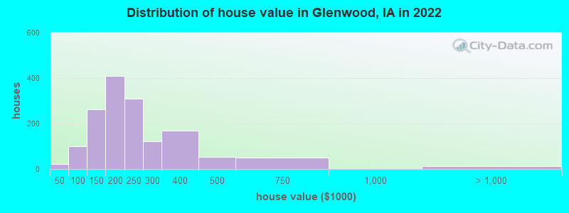
Estimated median house or condo value in 2022: $202,637 (it was $92,800 in 2000)
| Glenwood: | $202,637 |
| IA: | $194,600 |
Mean prices in 2022: all housing units: $280,299; detached houses: $286,392; townhouses or other attached units: $208,580; in 2-unit structures: $201,804; mobile homes: $115,320
Median gross rent in 2022: $738.
(9.4% for White Non-Hispanic residents, 1.9% for Hispanic or Latino residents, 12.1% for two or more races residents)
Detailed information about poverty and poor residents in Glenwood, IA


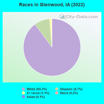
- 4,59589.3%White alone
- 4488.7%Hispanic
- 571.1%Two or more races
- 90.2%Black alone
- 70.1%Asian alone
Races in Glenwood detailed stats: ancestries, foreign born residents, place of birth
According to our research of Iowa and other state lists, there were 4 registered sex offenders living in Glenwood, Iowa as of May 11, 2024.
The ratio of all residents to sex offenders in Glenwood is 1,320 to 1.
The ratio of registered sex offenders to all residents in this city is much lower than the state average.
Type |
2009 |
2010 |
2011 |
2012 |
2013 |
2014 |
2015 |
2016 |
2017 |
2018 |
2019 |
2020 |
2021 |
2022 |
|---|---|---|---|---|---|---|---|---|---|---|---|---|---|---|
| Murders (per 100,000) | 0 (0.0) | 0 (0.0) | 0 (0.0) | 0 (0.0) | 1 (19.2) | 0 (0.0) | 0 (0.0) | 1 (19.0) | 0 (0.0) | 0 (0.0) | 0 (0.0) | 0 (0.0) | 0 (0.0) | 0 (0.0) |
| Rapes (per 100,000) | 2 (35.2) | 1 (19.0) | 3 (56.6) | 2 (38.0) | 4 (76.6) | 3 (56.9) | 2 (38.2) | 1 (19.0) | 5 (94.1) | 1 (18.8) | 5 (94.0) | 1 (18.5) | 2 (38.0) | 4 (77.0) |
| Robberies (per 100,000) | 0 (0.0) | 0 (0.0) | 1 (18.9) | 1 (19.0) | 1 (19.2) | 1 (19.0) | 0 (0.0) | 0 (0.0) | 0 (0.0) | 0 (0.0) | 0 (0.0) | 0 (0.0) | 0 (0.0) | 1 (19.2) |
| Assaults (per 100,000) | 7 (123.3) | 17 (322.6) | 15 (283.2) | 20 (379.7) | 21 (402.3) | 18 (341.5) | 27 (515.9) | 27 (514.3) | 13 (244.6) | 23 (432.6) | 28 (526.2) | 16 (296.2) | 9 (171.1) | 13 (250.2) |
| Burglaries (per 100,000) | 28 (493.4) | 54 (1,025) | 77 (1,454) | 43 (816.2) | 29 (555.6) | 31 (588.1) | 24 (458.5) | 26 (495.2) | 43 (809.0) | 21 (395.0) | 15 (281.9) | 24 (444.3) | 8 (152.1) | 11 (211.7) |
| Thefts (per 100,000) | 54 (951.5) | 61 (1,158) | 88 (1,661) | 74 (1,405) | 55 (1,054) | 46 (872.7) | 44 (840.7) | 50 (952.4) | 63 (1,185) | 41 (771.1) | 43 (808.1) | 45 (833.0) | 36 (684.4) | 25 (481.2) |
| Auto thefts (per 100,000) | 5 (88.1) | 5 (94.9) | 13 (245.4) | 4 (75.9) | 13 (249.0) | 4 (75.9) | 6 (114.6) | 8 (152.4) | 5 (94.1) | 8 (150.5) | 8 (150.3) | 14 (259.2) | 5 (95.1) | 10 (192.5) |
| Arson (per 100,000) | 2 (35.2) | 1 (19.0) | 1 (18.9) | 0 (0.0) | 1 (19.2) | 0 (0.0) | 0 (0.0) | 0 (0.0) | 0 (0.0) | 0 (0.0) | 0 (0.0) | 0 (0.0) | 1 (19.0) | 1 (19.2) |
| City-Data.com crime index | 132.5 | 205.4 | 295.5 | 231.4 | 286.8 | 201.7 | 208.6 | 241.1 | 235.7 | 172.1 | 244.5 | 159.2 | 110.3 | 166.9 |
The City-Data.com crime index weighs serious crimes and violent crimes more heavily. Higher means more crime, U.S. average is 246.1. It adjusts for the number of visitors and daily workers commuting into cities.
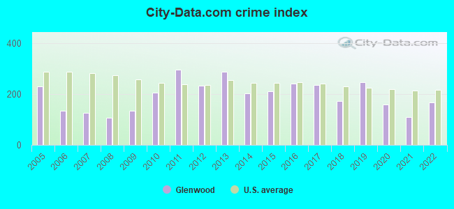
Crime rate in Glenwood detailed stats: murders, rapes, robberies, assaults, burglaries, thefts, arson
Full-time law enforcement employees in 2021, including police officers: 11 (10 officers - 9 male; 1 female).
| Officers per 1,000 residents here: | 1.90 |
| Iowa average: | 1.76 |
 Recent articles from our blog. Our writers, many of them Ph.D. graduates or candidates, create easy-to-read articles on a wide variety of topics.

 | Live in Council Bluffs, work in Omaha, NE? (11 replies) |
| Most significant tax reform bill signed-retirement/income (13 replies) |
| Being Gay in Small Town Iowa (40 replies) |
| Indianola (14 replies) |
| Dream town in Iowa (34 replies) |
| Glenwood, IA (2 replies) |
Latest news from Glenwood, IA collected exclusively by city-data.com from local newspapers, TV, and radio stations
Ancestries: German (34.7%), English (24.0%), American (8.7%), Irish (4.6%), Norwegian (4.1%), Italian (3.2%).
Current Local Time: CST time zone
Incorporated on 01/17/1857
Elevation: 1000 feet
Land area: 2.59 square miles.
Population density: 1,982 people per square mile (low).
111 residents are foreign born (1.2% Europe, 0.6% Latin America).
| This city: | 2.2% |
| Iowa: | 5.6% |
Median real estate property taxes paid for housing units with mortgages in 2022: $3,128 (1.6%)
Median real estate property taxes paid for housing units with no mortgage in 2022: $3,530 (1.7%)
Nearest city with pop. 50,000+: Council Bluffs, IA  (15.7 miles , pop. 58,268).
Nearest city with pop. 200,000+: Omaha, NE (20.5 miles , pop. 390,007).
Nearest city with pop. 1,000,000+: Chicago, IL (421.5 miles , pop. 2,896,016).
Nearest cities:
), ), Latitude: 41.05 N, Longitude: 95.74 W
Daytime population change due to commuting: -294 (-5.7%)
Workers who live and work in this city: 942 (39.4%)
Area code: 712
Glenwood, Iowa accommodation & food services, waste management - Economy and Business Data
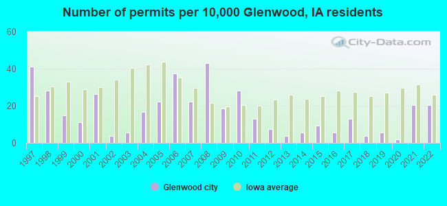
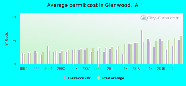
Single-family new house construction building permits:
- 2022: 11 buildings, average cost: $264,500
- 2021: 11 buildings, average cost: $193,600
- 2020: 1 building, cost: $150,000
- 2019: 3 buildings, average cost: $266,700
- 2018: 2 buildings, average cost: $180,000
- 2017: 7 buildings, average cost: $274,700
- 2016: 3 buildings, average cost: $363,300
- 2015: 5 buildings, average cost: $232,000
- 2014: 3 buildings, average cost: $214,700
- 2013: 2 buildings, average cost: $105,000
- 2012: 4 buildings, average cost: $148,800
- 2011: 7 buildings, average cost: $166,400
- 2010: 15 buildings, average cost: $133,700
- 2009: 10 buildings, average cost: $143,000
- 2008: 23 buildings, average cost: $135,500
- 2007: 12 buildings, average cost: $155,400
- 2006: 20 buildings, average cost: $147,800
- 2005: 12 buildings, average cost: $153,000
- 2004: 9 buildings, average cost: $125,000
- 2003: 3 buildings, average cost: $123,300
- 2002: 2 buildings, average cost: $129,000
- 2001: 14 buildings, average cost: $195,700
- 2000: 6 buildings, average cost: $93,500
- 1999: 8 buildings, average cost: $140,900
- 1998: 15 buildings, average cost: $123,100
- 1997: 22 buildings, average cost: $115,600
| Here: | 2.3% |
| Iowa: | 2.7% |
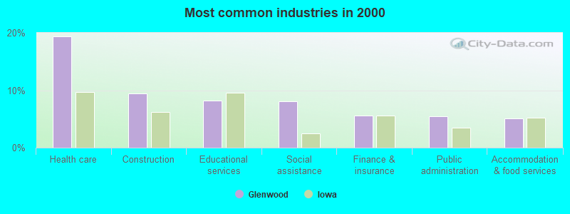
- Health care (19.4%)
- Construction (9.4%)
- Educational services (8.3%)
- Social assistance (8.1%)
- Finance & insurance (5.6%)
- Public administration (5.4%)
- Accommodation & food services (5.1%)
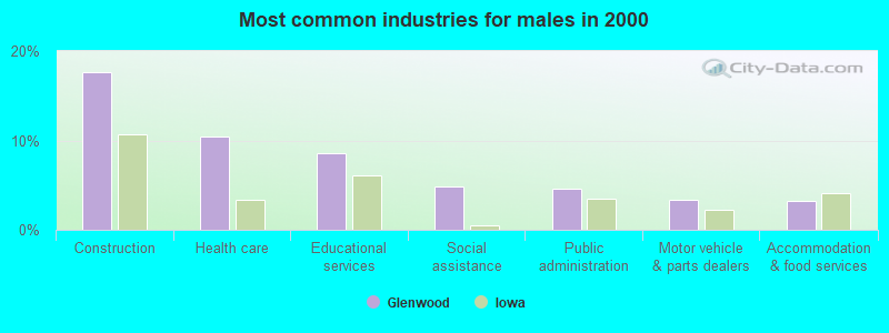
- Construction (17.7%)
- Health care (10.4%)
- Educational services (8.6%)
- Social assistance (4.8%)
- Public administration (4.6%)
- Motor vehicle & parts dealers (3.3%)
- Accommodation & food services (3.3%)
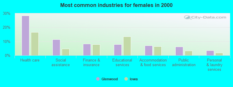
- Health care (28.3%)
- Social assistance (11.4%)
- Finance & insurance (8.3%)
- Educational services (7.9%)
- Accommodation & food services (7.0%)
- Public administration (6.2%)
- Personal & laundry services (3.5%)
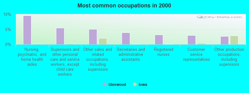
- Nursing, psychiatric, and home health aides (9.6%)
- Supervisors and other personal care and service workers, except child care workers (5.5%)
- Other sales and related occupations, including supervisors (5.0%)
- Secretaries and administrative assistants (3.9%)
- Registered nurses (3.2%)
- Customer service representatives (3.0%)
- Other production occupations, including supervisors (2.7%)
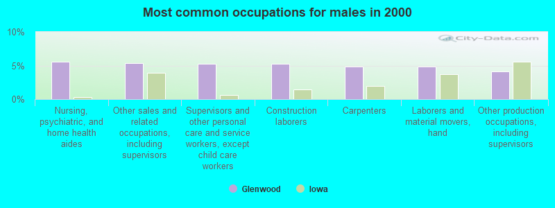
- Nursing, psychiatric, and home health aides (5.5%)
- Other sales and related occupations, including supervisors (5.4%)
- Supervisors and other personal care and service workers, except child care workers (5.3%)
- Construction laborers (5.2%)
- Carpenters (4.9%)
- Laborers and material movers, hand (4.8%)
- Other production occupations, including supervisors (4.2%)
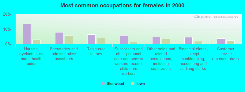
- Nursing, psychiatric, and home health aides (13.7%)
- Secretaries and administrative assistants (7.9%)
- Registered nurses (6.3%)
- Supervisors and other personal care and service workers, except child care workers (5.7%)
- Other sales and related occupations, including supervisors (4.7%)
- Financial clerks, except bookkeeping, accounting and auditing clerks (4.5%)
- Customer service representatives (3.6%)
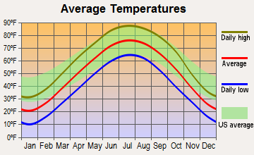
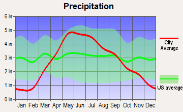
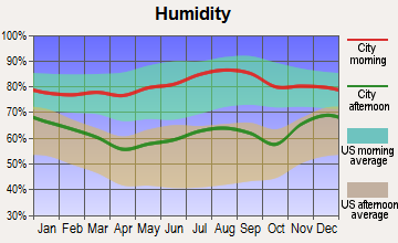
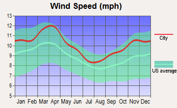
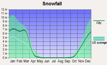
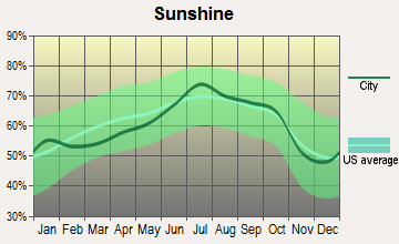
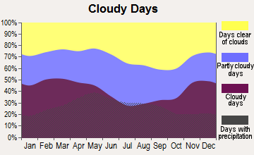
Average climate in Glenwood, Iowa
Based on data reported by over 4,000 weather stations
|
|

(lower is better)
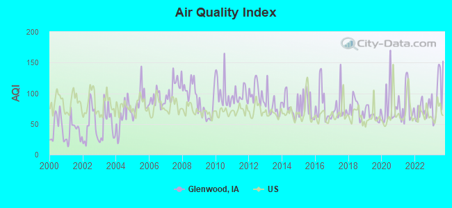
Air Quality Index (AQI) level in 2023 was 99.8. This is worse than average.
| City: | 99.8 |
| U.S.: | 72.6 |

Carbon Monoxide (CO) [ppm] level in 2023 was 0.195. This is better than average. Closest monitor was 17.6 miles away from the city center.
| City: | 0.195 |
| U.S.: | 0.251 |
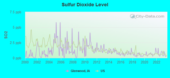
Sulfur Dioxide (SO2) [ppb] level in 2023 was 0.451. This is significantly better than average. Closest monitor was 10.2 miles away from the city center.
| City: | 0.451 |
| U.S.: | 1.515 |
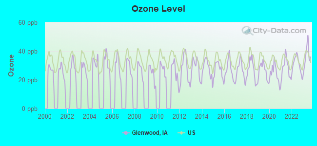
Ozone [ppb] level in 2023 was 36.1. This is about average. Closest monitor was 15.4 miles away from the city center.
| City: | 36.1 |
| U.S.: | 33.3 |
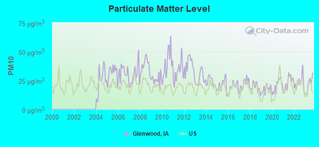
Particulate Matter (PM10) [µg/m3] level in 2023 was 21.5. This is about average. Closest monitor was 15.4 miles away from the city center.
| City: | 21.5 |
| U.S.: | 19.2 |
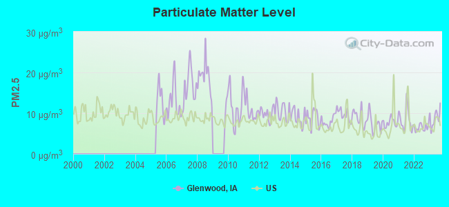
Particulate Matter (PM2.5) [µg/m3] level in 2023 was 8.82. This is about average. Closest monitor was 12.7 miles away from the city center.
| City: | 8.82 |
| U.S.: | 8.11 |
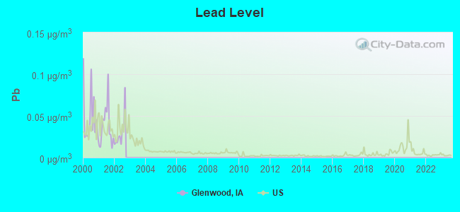
Lead (Pb) [µg/m3] level in 2002 was 0.0298. This is significantly worse than average. Closest monitor was 12.7 miles away from the city center.
| City: | 0.0298 |
| U.S.: | 0.0093 |
Tornado activity:
Glenwood-area historical tornado activity is near Iowa state average. It is 96% greater than the overall U.S. average.
On 4/25/1957, a category F4 (max. wind speeds 207-260 mph) tornado 17.6 miles away from the Glenwood city center killed one person and injured 8 people and caused between $500,000 and $5,000,000 in damages.
On 5/6/1975, a category F4 tornado 19.1 miles away from the city center killed 3 people and injured 133 people and caused between $50,000 and $500,000 in damages.
Earthquake activity:
Glenwood-area historical earthquake activity is significantly above Iowa state average. It is 324% greater than the overall U.S. average.On 9/3/2016 at 12:02:44, a magnitude 5.8 (5.8 MW, Depth: 3.5 mi, Class: Moderate, Intensity: VI - VII) earthquake occurred 325.9 miles away from the city center
On 11/6/2011 at 03:53:10, a magnitude 5.7 (5.7 MW, Depth: 3.2 mi) earthquake occurred 385.4 miles away from Glenwood center
On 11/12/2014 at 21:40:00, a magnitude 4.9 (4.9 MW, Depth: 2.5 mi, Class: Light, Intensity: IV - V) earthquake occurred 279.8 miles away from the city center
On 6/22/2019 at 08:50:24, a magnitude 4.6 (4.6 MW, Depth: 1.9 mi) earthquake occurred 232.3 miles away from Glenwood center
On 12/17/2009 at 02:53:42, a magnitude 3.6 (3.6 MB, Depth: 3.1 mi, Class: Light, Intensity: II - III) earthquake occurred 44.7 miles away from the city center
On 7/16/2004 at 12:17:30, a magnitude 3.5 (3.5 MW, Depth: 3.1 mi) earthquake occurred 30.3 miles away from Glenwood center
Magnitude types: body-wave magnitude (MB), moment magnitude (MW)
Natural disasters:
The number of natural disasters in Mills County (17) is near the US average (15).Major Disasters (Presidential) Declared: 15
Emergencies Declared: 1
Causes of natural disasters: Floods: 12, Storms: 11, Tornadoes: 6, Flash Flood: 1, Hurricane: 1, Ice Storm: 1, Snow: 1, Wind: 1, Other: 1 (Note: some incidents may be assigned to more than one category).

Hospitals and medical centers in Glenwood:
Colleges/universities with over 2000 students nearest to Glenwood:
- Bellevue University (about 12 miles; Bellevue, NE; Full-time enrollment: 7,139)
- Iowa Western Community College (about 17 miles; Council Bluffs, IA; FT enrollment: 5,344)
- Creighton University (about 19 miles; Omaha, NE; FT enrollment: 5,370)
- University of Nebraska Medical Center (about 19 miles; Omaha, NE; FT enrollment: 2,815)
- University of Nebraska at Omaha (about 21 miles; Omaha, NE; FT enrollment: 12,073)
- Metropolitan Community College Area (about 22 miles; Omaha, NE; FT enrollment: 12,236)
- Southeast Community College Area (about 50 miles; Lincoln, NE; FT enrollment: 8,838)
Public high school in Glenwood:
- GLENWOOD SENIOR HIGH SCHOOL (Students: 605, Location: 504 EAST SHARP STREET, Grades: 9-12)
Public elementary/middle schools in Glenwood:
- NORTHEAST ELEMENTARY SCHOOL (Students: 583, Location: 901 N. VINE STREET, Grades: PK-2)
- GLENWOOD MIDDLE SCHOOL (Students: 326, Location: 400 SIVERS ROAD, Grades: 6-8)
- WEST ELEMENTARY SCHOOL (Location: 707 SHARP ST, Grades: 3-5)
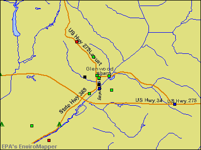
Points of interest:
Notable locations in Glenwood: Glenwood (A), Glenwood Recreation Complex (B), Mills County Jail (C), Glenwood City Library (D), Mills County Museum (E), Glenwood Police Department (F), Mills County Courthouse (G), Mills County Sheriffs Office (H), Glenwood Volunteer Fire and Rescue Department (I). Display/hide their locations on the map
Churches in Glenwood include: Glenwood Evangelical Free Church (A), First Church of the Nazarene (B), Nazarene Church (C), Bible Baptist Church (D), Saint John Episcopal Church (E), First Christian Church (F), First Baptist Church (G), Grace United Methodist Church (H), First Congregational Church (I). Display/hide their locations on the map
Cemetery: State Cemetery (1). Display/hide its location on the map
Park in Glenwood: Glenwood Lake Park (1). Display/hide its location on the map
Hotel: Glenwood Western Inn Motor Lodge (707 South Locust Street).
Birthplace of: Elmer Burkett - Politician.
Drinking water stations with addresses in Glenwood and their reported violations in the past:
GLENWOOD MUNICIPAL UTILITIES (Address: 7 N VINE ST , Population served: 5,740, Groundwater):Past health violations:THE WILDS RV & GOLF RESORT (Address: 57963 INGLEWOOD LN , Population served: 58, Groundwater):
- MCL, Average - Between OCT-2012 and DEC-2012, Contaminant: TTHM. Follow-up actions: St BCA signed (MAY-12-2011), St Formal NOV issued (OCT-12-2012), St Public Notif requested (OCT-12-2012), St Public Notif received (DEC-13-2012), St Compliance achieved (JAN-07-2013)
- MCL, Average - Between JUL-2012 and SEP-2012, Contaminant: TTHM. Follow-up actions: St BCA signed (MAY-12-2011), St Formal NOV issued (JUL-18-2012), St Public Notif requested (JUL-18-2012), St Public Notif received (AUG-20-2012), St Compliance achieved (JAN-07-2013)
- MCL, Average - Between APR-2012 and JUN-2012, Contaminant: TTHM. Follow-up actions: St BCA signed (MAY-12-2011), St Public Notif requested (APR-24-2012), St Formal NOV issued (APR-24-2012), St Public Notif received (JUN-04-2012), St Compliance achieved (JAN-07-2013)
- MCL, Average - Between JAN-2012 and MAR-2012, Contaminant: TTHM. Follow-up actions: St BCA signed (MAY-12-2011), St Formal NOV issued (MAR-19-2012), St Public Notif requested (MAR-19-2012), St Public Notif received (APR-05-2012), St Compliance achieved (JAN-07-2013)
- MCL, Average - Between OCT-2011 and DEC-2011, Contaminant: TTHM. Follow-up actions: St Public Notif received (JAN-11-2011), St BCA signed (MAY-12-2011), St Formal NOV issued (DEC-09-2011), St Public Notif requested (DEC-09-2011), St Compliance achieved (JAN-07-2013)
- MCL, Average - Between JUL-2011 and SEP-2011, Contaminant: TTHM. Follow-up actions: St BCA signed (MAY-12-2011), St Formal NOV issued (AUG-30-2011), St Public Notif requested (AUG-30-2011), St Public Notif received (OCT-18-2011), St Compliance achieved (JAN-07-2013)
- 5 other older health violations
Past health violations:COUNTRY ESTATES MOBILE HOME PARK (Address: 57963 INGLEWOOD LANE , Population served: 35, Groundwater):Past monitoring violations:
- MCL, Monthly (TCR) - In NOV-2010, Contaminant: Coliform. Follow-up actions: St Public Notif requested (NOV-18-2010), St Formal NOV issued (NOV-18-2010), St Compliance achieved (MAY-03-2011), St Public Notif received (JUN-08-2011)
- MCL, Monthly (TCR) - In OCT-2010, Contaminant: Coliform. Follow-up actions: St Violation/Reminder Notice (OCT-28-2010), St Public Notif requested (APR-27-2011), St Formal NOV issued (APR-27-2011), St Compliance achieved (MAY-03-2011), St Public Notif received (JUN-08-2011)
- MCL, Monthly (TCR) - In OCT-2008, Contaminant: Coliform. Follow-up actions: St Public Notif requested (OCT-31-2008), St Formal NOV issued (OCT-31-2008), St Public Notif received (DEC-19-2008), St Compliance achieved (MAY-19-2009)
- Monitoring, Repeat Major (TCR) - In NOV-2010, Contaminant: Coliform (TCR). Follow-up actions: St Public Notif requested (DEC-15-2010), St Formal NOV issued (DEC-15-2010), St Compliance achieved (MAY-03-2011), St Public Notif received (JUN-08-2011)
- Monitoring, Repeat Major (TCR) - Between OCT-2010 and NOV-2010, Contaminant: Coliform (TCR). Follow-up actions: St Public Notif requested (DEC-15-2010), St Formal NOV issued (DEC-15-2010), St Compliance achieved (MAY-03-2011), St Public Notif received (JUN-08-2011)
- 5 routine major monitoring violations
- One minor monitoring violation
- One regular monitoring violation
Past health violations:Past monitoring violations:
- MCL, Monthly (TCR) - In SEP-2007, Contaminant: Coliform. Follow-up actions: St Violation/Reminder Notice (SEP-12-2007), St Boil Water Order (SEP-17-2007), St Public Notif received (SEP-19-2007), St Compliance achieved (MAR-11-2008)
- MCL, Acute (TCR) - In SEP-2007, Contaminant: Coliform. Follow-up actions: St Formal NOV issued (SEP-17-2007), St Boil Water Order (SEP-17-2007), St Public Notif requested (SEP-17-2007), St Public Notif received (SEP-19-2007), St Compliance achieved (MAR-11-2008)
- Follow-up Or Routine LCR Tap M/R - In JUN-01-2006, Contaminant: Lead and Copper Rule. Follow-up actions: St Public Notif requested (DEC-06-2006), St Formal NOV issued (DEC-06-2006), St Compliance achieved (SEP-21-2007), St Public Notif received (SEP-26-2007)
- One minor monitoring violation
| This city: | 2.5 people |
| Iowa: | 2.4 people |
| This city: | 66.0% |
| Whole state: | 64.7% |
| This city: | 7.3% |
| Whole state: | 6.7% |
Likely homosexual households (counted as self-reported same-sex unmarried-partner households)
- Lesbian couples: 0.2% of all households
- Gay men: 0.0% of all households
People in group quarters in Glenwood in 2010:
- 300 people in state prisons
- 109 people in residential treatment centers for adults
- 94 people in nursing facilities/skilled-nursing facilities
- 28 people in group homes intended for adults
- 13 people in group homes for juveniles (non-correctional)
- 8 people in local jails and other municipal confinement facilities
People in group quarters in Glenwood in 2000:
- 367 people in schools, hospitals, or wards for the intellectually disabled
- 114 people in homes for the mentally retarded
- 71 people in nursing homes
- 32 people in homes for the physically handicapped
- 15 people in institutions for the blind
- 14 people in orthopedic wards and institutions for the physically handicapped
- 13 people in local jails and other confinement facilities (including police lockups)
Banks with branches in Glenwood (2011 data):
- Glenwood State Bank: at 32 North Walnut Street, branch established on 1899/01/01; Glenwood State Plaza Branch at 960 South Locust, branch established on 1977/06/20. Info updated 2009/09/10: Bank assets: $149.0 mil, Deposits: $134.1 mil, local headquarters, positive income, Agricultural Specialization, 5 total offices, Holding Company: Glenwood Bancorporation
- First National Bank of Omaha: Mills County Bank, National Association at 102 South Locust Street, branch established on 1883/01/01. Info updated 2010/10/13: Bank assets: $13,433.1 mil, Deposits: $10,746.6 mil, headquarters in Omaha, NE, positive income, Commercial Lending Specialization, 102 total offices, Holding Company: Lauritzen Corporation
- Great Western Bank: 201 S Locust Branch at 201 South Locust, branch established on 1923/01/01. Info updated 2010/06/08: Bank assets: $8,458.0 mil, Deposits: $6,362.5 mil, headquarters in Watertown, SD, positive income, Commercial Lending Specialization, 187 total offices, Holding Company: National Australia Bank Limited
For population 15 years and over in Glenwood:
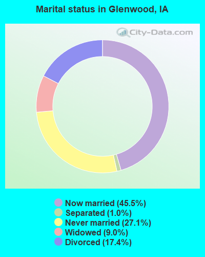
- Never married: 27.1%
- Now married: 45.5%
- Separated: 1.0%
- Widowed: 9.0%
- Divorced: 17.4%
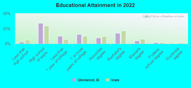
For population 25 years and over in Glenwood:
- High school or higher: 96.8%
- Bachelor's degree or higher: 23.4%
- Graduate or professional degree: 6.9%
- Unemployed: 8.5%
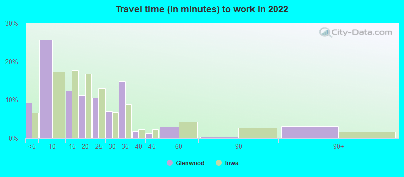
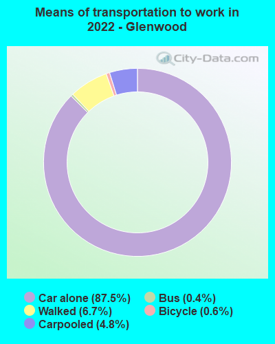
- Mean travel time to work (commute): 19.6 minutes
| Here: | 8.1 |
| Iowa average: | 10.5 |
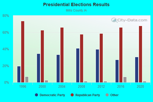
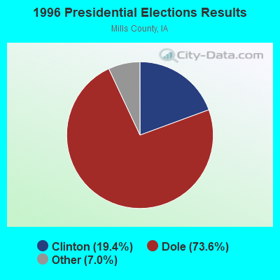
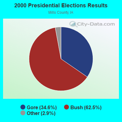
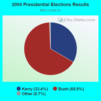

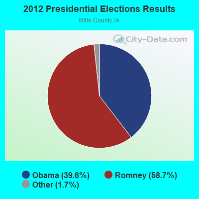
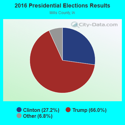
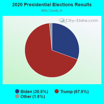
Graphs represent county-level data. Detailed 2008 Election Results
Religion statistics for Glenwood, IA (based on Mills County data)
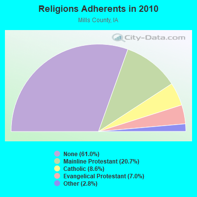
| Religion | Adherents | Congregations |
|---|---|---|
| Mainline Protestant | 3,113 | 16 |
| Catholic | 1,295 | 1 |
| Evangelical Protestant | 1,052 | 9 |
| Other | 416 | 1 |
| None | 9,183 | - |
Food Environment Statistics:
| This county: | 1.98 / 10,000 pop. |
| Iowa: | 2.14 / 10,000 pop. |
| Mills County: | 4.63 / 10,000 pop. |
| State: | 5.55 / 10,000 pop. |
| Here: | 4.63 / 10,000 pop. |
| Iowa: | 8.01 / 10,000 pop. |
| This county: | 7.4% |
| Iowa: | 7.8% |
| Mills County: | 28.2% |
| Iowa: | 27.3% |
| This county: | 16.7% |
| Iowa: | 14.5% |
Health and Nutrition:
| Glenwood: | 46.4% |
| Iowa: | 49.5% |
| Glenwood: | 41.4% |
| Iowa: | 46.1% |
| This city: | 29.0 |
| Iowa: | 28.6 |
| Glenwood: | 23.6% |
| Iowa: | 21.4% |
| Here: | 10.7% |
| Iowa: | 10.4% |
| This city: | 6.8 |
| Iowa: | 6.8 |
| Here: | 33.9% |
| Iowa: | 33.8% |
| This city: | 53.3% |
| State: | 55.9% |
| This city: | 76.9% |
| Iowa: | 77.7% |
More about Health and Nutrition of Glenwood, IA Residents
| Local government employment and payroll (March 2022) | |||||
| Function | Full-time employees | Monthly full-time payroll | Average yearly full-time wage | Part-time employees | Monthly part-time payroll |
|---|---|---|---|---|---|
| Police Protection - Officers | 10 | $94,756 | $113,707 | 0 | $0 |
| Local Libraries | 5 | $16,907 | $40,577 | 3 | $2,882 |
| Streets and Highways | 5 | $22,829 | $54,790 | 0 | $0 |
| Other Government Administration | 2 | $6,377 | $38,262 | 0 | $0 |
| Parks and Recreation | 2 | $7,713 | $46,278 | 0 | $0 |
| Other and Unallocable | 1 | $4,616 | $55,392 | 0 | $0 |
| Firefighters | 1 | $4,684 | $56,208 | 0 | $0 |
| Police - Other | 1 | $4,163 | $49,956 | 0 | $0 |
| Financial Administration | 1 | $5,365 | $64,380 | 0 | $0 |
| Totals for Government | 28 | $167,411 | $71,748 | 3 | $2,882 |
Glenwood government finances - Expenditure in 2021 (per resident):
- Current Operations - Police Protection: $1,119,000 ($217.87)
Regular Highways: $600,000 ($116.82)
Parks and Recreation: $577,000 ($112.34)
Libraries: $360,000 ($70.09)
Local Fire Protection: $324,000 ($63.08)
General - Other: $277,000 ($53.93)
Central Staff Services: $262,000 ($51.01)
Miscellaneous Commercial Activities - Other: $152,000 ($29.60)
Judicial and Legal Services: $60,000 ($11.68)
Housing and Community Development: $53,000 ($10.32)
Solid Waste Management: $5,000 ($0.97)
Financial Administration: $1,000 ($0.19)
Health - Other: $1,000 ($0.19)
- General - Interest on Debt: $206,000 ($40.11)
- Total Salaries and Wages: $1,435,000 ($279.40)
Glenwood government finances - Revenue in 2021 (per resident):
- Charges - Parks and Recreation: $112,000 ($21.81)
Other: $48,000 ($9.35)
Miscellaneous Commercial Activities: $34,000 ($6.62)
- Federal Intergovernmental - Other: $130,000 ($25.31)
Public Welfare: $107,000 ($20.83)
- Local Intergovernmental - Other: $220,000 ($42.83)
- Miscellaneous - General Revenue - Other: $352,000 ($68.54)
Sale of Property: $19,000 ($3.70)
Fines and Forfeits: $6,000 ($1.17)
Interest Earnings: $2,000 ($0.39)
Rents: $1,000 ($0.19)
- State Intergovernmental - Highways: $789,000 ($153.62)
Other: $100,000 ($19.47)
General Local Government Support: $38,000 ($7.40)
- Tax - Property: $2,766,000 ($538.55)
General Sales and Gross Receipts: $607,000 ($118.19)
Public Utilities Sales: $304,000 ($59.19)
Other License: $15,000 ($2.92)
Glenwood government finances - Debt in 2021 (per resident):
- Long Term Debt - Beginning Outstanding - Unspecified Public Purpose: $7,295,000 ($1420.37)
Outstanding Unspecified Public Purpose: $6,872,000 ($1338.01)
Retired Unspecified Public Purpose: $423,000 ($82.36)
Glenwood government finances - Cash and Securities in 2021 (per resident):
- Bond Funds - Cash and Securities: $468,000 ($91.12)
- Other Funds - Cash and Securities: $4,059,000 ($790.30)
- Sinking Funds - Cash and Securities: $23,000 ($4.48)
| Businesses in Glenwood, IA | ||||
| Name | Count | Name | Count | |
|---|---|---|---|---|
| FedEx | 1 | Subway | 1 | |
| H&R Block | 1 | True Value | 1 | |
| Kroger | 1 | U.S. Cellular | 1 | |
| McDonald's | 1 | UPS | 2 | |
| Pizza Hut | 1 | YMCA | 1 | |
| RadioShack | 1 | |||
Strongest AM radio stations in Glenwood:
- KOIL (1020 AM; 50 kW; PLATTSMOUTH, NE; Owner: WAITT RADIO, INC.)
- KFAB (1110 AM; 50 kW; OMAHA, NE; Owner: CAPSTAR TX LIMITED PARTNERSHIP)
- KKAR (1290 AM; 50 kW; OMAHA, NE; Owner: WAITT RADIO, INC.)
- KYDZ (1180 AM; 25 kW; BELLEVUE, NE; Owner: WAITT RADIO, INC.)
- KLNG (1560 AM; daytime; 10 kW; COUNCIL BLUFFS, IA)
- KOZN (1620 AM; 10 kW; BELLEVUE, NE; Owner: WAITT RADIO, INC.)
- KOMJ (590 AM; 5 kW; OMAHA, NE; Owner: JOURNAL BROADCAST CORPORATION)
- KMA (960 AM; 5 kW; SHENANDOAH, IA; Owner: KMA BROADCASTING L.P.)
- KHLP (1420 AM; 1 kW; OMAHA, NE; Owner: JOURNAL BROADCAST CORPORATION)
- KYFR (920 AM; 5 kW; SHENANDOAH, IA; Owner: FAMILY STATIONS, INC.)
- WHB (810 AM; 50 kW; KANSAS CITY, MO; Owner: UNION BROADCASTING, INC.)
- WHO (1040 AM; 50 kW; DES MOINES, IA; Owner: CITICASTERS LICENSES, L.P.)
- KCRO (660 AM; 1 kW; OMAHA, NE; Owner: ETERNAL BROADCASTING, LLC)
Strongest FM radio stations in Glenwood:
- KMLV (88.1 FM; RALSTON, NE; Owner: EDUCATIONAL MEDIA FOUNDATION)
- KEFM (96.1 FM; OMAHA, NE; Owner: WEBSTER COMMUNICATIONS CO.)
- KCTY-FM (106.9 FM; PLATTSMOUTH, NE; Owner: PLATTE BROADCASTING COMPANY, INC.)
- KGOR (99.9 FM; OMAHA, NE; Owner: CAPSTAR TX LIMITED PARTNERSHIP)
- KQCH (94.1 FM; OMAHA, NE; Owner: JOURNAL BROADCAST CORPORATION)
- KLTQ (101.9 FM; LINCOLN, NE; Owner: WAITT RADIO, INC.)
- KEZO-FM (92.3 FM; OMAHA, NE; Owner: JOURNAL BROADCAST CORPORATION)
- KQKQ-FM (98.5 FM; COUNCIL BLUFFS, IA; Owner: WAITT RADIO, INC.)
- KGBI-FM (100.7 FM; OMAHA, NE; Owner: GRACE UNIVERSITY)
- KSRZ (104.5 FM; OMAHA, NE; Owner: JOURNAL BROADCAST CORPORATION)
- KIWR (89.7 FM; COUNCIL BLUFFS, IA; Owner: IOWA WESTERN COMMUNITY COLLEGE)
- KXKT (103.7 FM; GLENWOOD, IA; Owner: CAPSTAR TX LIMITED PARTNERSHIP)
- KBBX-FM (97.7 FM; NEBRASKA CITY, NE; Owner: JOURNAL BROADCAST CORPORATION)
- KVNO (90.7 FM; OMAHA, NE; Owner: THE BOARD OF REGENTS OF UNIV. OF NEBRASKA)
- KIOS-FM (91.5 FM; OMAHA, NE; Owner: DOUGLAS COUNTY SCHOOL DISTRICT 001)
- KFRX (102.7 FM; LINCOLN, NE; Owner: THREE EAGLES OF LINCOLN, INC.)
- K299AK (107.7 FM; OMAHA, NE; Owner: BAER COMMUNICATIONS, INC.)
- KKCD (105.9 FM; OMAHA, NE; Owner: JOURNAL BROADCAST CORPORATION)
- KVSS (88.9 FM; OMAHA, NE; Owner: VSS CATHOLIC COMMUNICATIONS, INC.)
- KCSI (95.3 FM; RED OAK, IA; Owner: HAWKEYE COMMUNICATIONS, INC.)
TV broadcast stations around Glenwood:
- KYNE-TV (Channel 26; OMAHA, NE; Owner: NEBRASKA EDUCATIONAL TELECOMMUNICATIONS COMM.)
- KMTV (Channel 3; OMAHA, NE; Owner: EMMIS TELEVISION LICENSE CORPORATION)
- KETV (Channel 7; OMAHA, NE; Owner: KETV HEARST-ARGYLE TELEVISION, INC.)
- KPTM (Channel 42; OMAHA, NE; Owner: PAPPAS TELECASTING OF THE MIDLANDS)
- KXVO (Channel 15; OMAHA, NE; Owner: MITTS TELECASTING COMPANY)
- WOWT-TV (Channel 6; OMAHA, NE; Owner: GRAY MIDAMERICA TV LICENSEE CORP.)
- KVSS-LP (Channel 67; OMAHA, NE; Owner: VSS CATHOLIC COMMUNICATIONS)
- KUON-TV (Channel 12; LINCOLN, NE; Owner: THE UNIVERSITY OF NEBRASKA)
- KHIN (Channel 36; RED OAK, IA; Owner: IOWA PUBLIC BROADCASTING BOARD)
- K61GA (Channel 61; OMAHA, NE; Owner: THREE ANGELS BROADCASTING NETWORK)
- KKAZ-CA (Channel 24; OMAHA, NE; Owner: PAPPAS TELECASTING OF THE MIDLANDS)
- K52GP (Channel 52; COUNCIL BLUFFS, IA; Owner: DOUGLAS SHELDAHL)
- K54GL (Channel 54; COUNCIL BLUFFS, IA; Owner: TV-45, INC.)
- KBIN-TV (Channel 32; COUNCIL BLUFFS, IA; Owner: IOWA PUBLIC BROADCASTING BOARD)
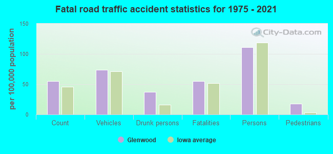
Glenwood fatal accident list:
Oct 24, 1996 01:28 PM, 275, Vehicles: 2, Persons: 2, Fatalities: 1
Jun 3, 1981 07:20 PM, Vehicles: 1, Persons: 2, Fatalities: 1, Drunk persons involved: 1
- National Bridge Inventory (NBI) Statistics
- 25Number of bridges
- 341ft / 104mTotal length
- 41,680Total average daily traffic
- 2,480Total average daily truck traffic
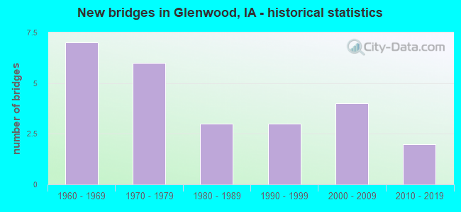
- New bridges - historical statistics
- 71960-1969
- 61970-1979
- 31980-1989
- 31990-1999
- 42000-2009
- 22010-2019
FCC Registered Cell Phone Towers:
3 (See the full list of FCC Registered Cell Phone Towers in Glenwood)FCC Registered Antenna Towers:
193 (See the full list of FCC Registered Antenna Towers)FCC Registered Commercial Land Mobile Towers:
1 (See the full list of FCC Registered Commercial Land Mobile Towers in Glenwood, IA)FCC Registered Private Land Mobile Towers:
2 (See the full list of FCC Registered Private Land Mobile Towers)FCC Registered Broadcast Land Mobile Towers:
17 (See the full list of FCC Registered Broadcast Land Mobile Towers)FCC Registered Microwave Towers:
19 (See the full list of FCC Registered Microwave Towers in this town)FCC Registered Amateur Radio Licenses:
59 (See the full list of FCC Registered Amateur Radio Licenses in Glenwood)FAA Registered Aircraft:
6- Aircraft: BELLANCA 17-30A (Category: Land, Seats: 4, Weight: Up to 12,499 Pounds, Speed: 142 mph), Engine: CONT MOTOR IO 520 SERIES (285 HP) (Reciprocating)
N-Number: 115CC, N115CC, N-115CC, Serial Number: 7930931, Year manufactured: 1979, Airworthiness Date: 03/23/1979, Certificate Issue Date: 09/09/2011
Registrant (Co-Owned): Joseph C Murphy, 60246 Levi Rd, Glenwood, IA 51534, Other Owners: Katherine J Kaminsky - Aircraft: PIPER PA-18-125 (Category: Land, Seats: 2, Weight: Up to 12,499 Pounds, Speed: 97 mph), Engine: LYCOMING 0-290 SERIES (140 HP) (Reciprocating)
N-Number: 1346A, N1346A, N-1346A, Serial Number: 18-1164, Year manufactured: 1951, Airworthiness Date: 02/22/1956, Certificate Issue Date: 03/16/2020
Registrant (LLC): Safeflite Aviation LLC, 55120 Fesner Ln, Glenwood, IA 51534 - Aircraft: STRATBUCKER GEORGE W STOL CH801 (Category: Land, Seats: 4, Weight: Up to 12,499 Pounds), Engine: LYCOMING O-360 SERIES (180 HP) (Reciprocating)
N-Number: 1932V, N1932V, N-1932V, Serial Number: 84232, Year manufactured: 2005, Airworthiness Date: 11/29/2005, Certificate Issue Date: 03/03/2003
Registrant (Corporation): Stratbucker Farms Inc, 61395 Levi Rd, Glenwood, IA 51534 - Aircraft: CESSNA 182D (Category: Land, Seats: 4, Weight: Up to 12,499 Pounds, Speed: 119 mph), Engine: CONT MOTOR O-470 SERIES (230 HP) (Reciprocating)
N-Number: 8898X, N8898X, N-8898X, Serial Number: 18253298, Year manufactured: 1961, Airworthiness Date: 02/21/1961, Certificate Issue Date: 02/24/2016
Registrant (Individual): Matthew M Sargent, 21806 Henton Dr, Glenwood, IA 51534 - Aircraft: AS+ LTD AC 4 (Category: Land, Weight: Up to 12,499 Pounds), Engine: None
N-Number: 358R, N358R, N-358R, Serial Number: 025, Year manufactured: 1997, Airworthiness Date: 05/06/1998, Certificate Issue Date: 12/09/2016
Registrant (Individual): Michael D Boska, 54216 Elrod Rd, Glenwood, IA 51534 - Aircraft: TAYLORCRAFT DC-65 (Category: Land, Seats: 2, Weight: Up to 12,499 Pounds, Speed: 82 mph), Engine: CONT MOTOR A&C65 SERIES (65 HP) (Reciprocating)
N-Number: 57922, N57922, N-57922, Serial Number: 5744, Year manufactured: 1943
Registrant (Individual): Lynn Schoening, , Glenwood, IA 51534
Deregistered: Cancel Date: 11/08/2019
2002 - 2018 National Fire Incident Reporting System (NFIRS) incidents
- Fire incident types reported to NFIRS in Glenwood, IA
- 15154.3%Outside Fires
- 7426.6%Structure Fires
- 3914.0%Mobile Property/Vehicle Fires
- 145.0%Other
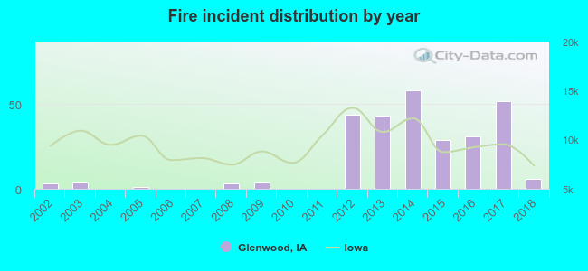 According to the data from the years 2002 - 2018 the average number of fires per year is 16. The highest number of fires - 58 took place in 2014, and the least - 0 in 2004. The data has a rising trend.
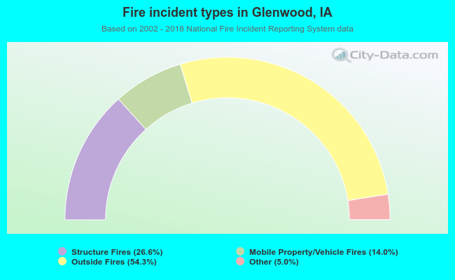 When looking into fire subcategories, the most incidents belonged to: Outside Fires (54.3%), and Structure Fires (26.6%).
| Most common first names in Glenwood, IA among deceased individuals | ||
| Name | Count | Lived (average) |
|---|---|---|
| John | 39 | 72.7 years |
| William | 36 | 73.1 years |
| Mary | 34 | 77.3 years |
| Charles | 30 | 74.8 years |
| Robert | 30 | 71.8 years |
| James | 27 | 60.6 years |
| Donald | 24 | 63.7 years |
| Dorothy | 22 | 78.8 years |
| Ruth | 21 | 81.0 years |
| Harold | 18 | 73.0 years |
| Most common last names in Glenwood, IA among deceased individuals | ||
| Last name | Count | Lived (average) |
|---|---|---|
| Johnson | 21 | 76.6 years |
| Schoening | 19 | 78.3 years |
| Miller | 17 | 76.8 years |
| Smith | 15 | 69.8 years |
| Williams | 15 | 78.4 years |
| Ross | 14 | 78.1 years |
| Clark | 11 | 76.5 years |
| Fisher | 11 | 71.5 years |
| Thomas | 11 | 75.5 years |
| Jens | 11 | 79.4 years |
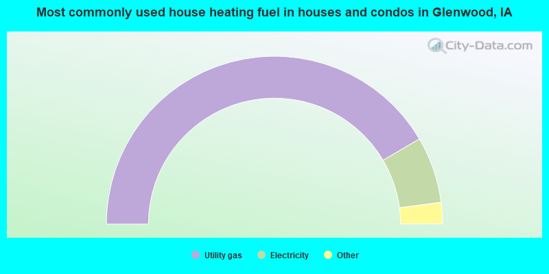
- 83.1%Utility gas
- 12.8%Electricity
- 3.0%Bottled, tank, or LP gas
- 1.1%Wood
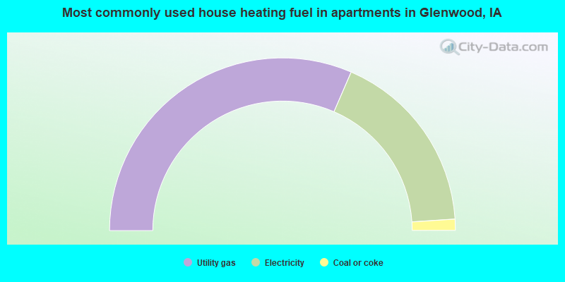
- 63.0%Utility gas
- 34.9%Electricity
- 2.1%Coal or coke
Glenwood compared to Iowa state average:
- Black race population percentage significantly below state average.
- Median age below state average.
- Foreign-born population percentage significantly below state average.
- Length of stay since moving in significantly below state average.
- Institutionalized population percentage significantly above state average.
- Number of college students below state average.
Glenwood on our top lists:
- #6 on the list of "Top 101 cities with the largest percentage of people in schools, hospitals, or wards for the mentally retarded (population 1,000+)"
- #11 on the list of "Top 101 cities with the largest percentage of people in institutions for the blind (population 1,000+)"
- #30 on the list of "Top 101 cities with the largest percentage of people in homes for the physically handicapped (population 1,000+)"
- #31 on the list of "Top 101 cities with the smallest percentage of likely homosexual households (counted as self-reported same-sex unmarried-partner households) (population 5,000+)"
- #41 on the list of "Top 101 cities with the largest percentage of people in homes for the mentally retarded (population 1,000+)"
- #63 on the list of "Top 101 cities with the largest percentage of people in orthopedic wards and institutions for the physically handicapped (population 1,000+)"
- #76 on the list of "Top 101 cities with largest percentage of males in occupations: material moving occupations (population 5,000+)"
- #91 on the list of "Top 101 cities with largest percentage of males in industries: management of companies and enterprises (population 5,000+)"

|
Total of 3 patent applications in 2008-2024.