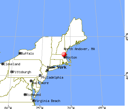
North Andover, Massachusetts
Submit your own pictures of this town and show them to the world
- OSM Map
- General Map
- Google Map
- MSN Map
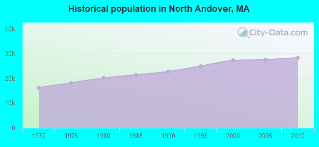
Population change since 2000: +4.2%
 |
| Males: 13,535 | |
| Females: 14,817 |
| Median resident age: | 40.1 years |
| Massachusetts median age: | 39.2 years |
Zip codes: 01845.
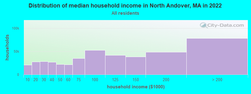
| North Andover: | $130,313 |
| MA: | $94,488 |
Estimated per capita income in 2022: $66,755 (it was $34,335 in 2000)
North Andover town income, earnings, and wages data
Estimated median house or condo value in 2022: $792,843 (it was $282,300 in 2000)
| North Andover: | $792,843 |
| MA: | $534,700 |
Mean prices in 2022: all housing units: $645,471; detached houses: $712,185; townhouses or other attached units: $551,275; in 2-unit structures: $503,219; in 3-to-4-unit structures: $450,535; in 5-or-more-unit structures: $352,534; mobile homes: $123,118; occupied boats, rvs, vans, etc.: $131,058
Detailed information about poverty and poor residents in North Andover, MA


Compare current foreclosures near North Andover, MA:
| Photo | Address | Area | Beds / Baths | Price | Details |
|---|---|---|---|---|---|

|
#1
Salem St
North Andover, MA 01845
|
1,572 sq. feet
|
1 baths 2 beds |
show details | |

|
#2
Winter St
North Andover, MA 01845
|
2,445 sq. feet
|
2 baths 3 beds |
show details | |

|
#3
Avery Park Dr
North Andover, MA 01845
|
3,471 sq. feet
|
2 baths 4 beds |
show details | |

|
#4
Marengo St # 4
North Andover, MA 01845
|
1,765 sq. feet
|
3 baths 2 beds |
show details | |

|
#5
Chestnut St
North Andover, MA 01845
|
2,516 sq. feet
|
3 baths 4 beds |
show details | |

|
#6
Thorndike Rd
North Andover, MA 01845
|
1,297 sq. feet
|
2 baths 4 beds |
show details | |

|
#7
Phillips Cmn
North Andover, MA 01845
|
1,897 sq. feet
|
2 baths 3 beds |
show details | |

|
#8
Ardmore Ct
North Andover, MA 01845
|
- sq. feet
|
- baths - beds |
show details | |

|
#9
Compass Pt # F-3
North Andover, MA 01845
|
- sq. feet
|
- baths - beds |
show details | |

|
#10
Cedar St # A
Haverhill, MA 01830
|
1,134 sq. feet
|
2 baths 2 beds |
$209,300
|
show details |
| Photo | Address | Area | Beds / Baths | Price | Details |
|---|---|---|---|---|---|

|
#11
Shore Dr
Hampstead, NH 03841
|
787 sq. feet
|
1 baths 2 beds |
$529,900
|
show details |

|
#12
Pine Ridge Rd
Windham, NH 03087
|
1,746 sq. feet
|
2 baths 4 beds |
show details | |

|
#13
Mill River Ln
Rowley, MA 01969
|
2,705 sq. feet
|
2 baths 4 beds |
show details | |

|
#14
Salem Rd
Billerica, MA 01821
|
1,428 sq. feet
|
1 baths 4 beds |
show details | |

|
#15
Weare St
Lawrence, MA 01843
|
1,222 sq. feet
|
1 baths 3 beds |
show details | |

|
#16
Tobey Ln
Wakefield, MA 01880
|
3,240 sq. feet
|
2 baths 4 beds |
show details | |

|
#17
Forest Park Rd
Woburn, MA 01801
|
1,132 sq. feet
|
1 baths 3 beds |
show details | |

|
#18
S Broadway
Lawrence, MA 01843
|
5,706 sq. feet
|
2 baths 6 beds |
show details | |

|
#19
Chase St
Beverly, MA 01915
|
1,407 sq. feet
|
1 baths 3 beds |
show details | |

|
#20
Williamine Dr
Newton, NH 03858
|
2,295 sq. feet
|
1 baths 3 beds |
show details |
| Photo | Address | Area | Beds / Baths | Price | Details |
|---|---|---|---|---|---|

|
#21
Catalpa St
Wakefield, MA 01880
|
1,650 sq. feet
|
2 baths 3 beds |
show details | |

|
#22
Middlesex Tpke
Billerica, MA 01821
|
1,175 sq. feet
|
1 baths 3 beds |
show details | |

|
#23
Preston St Apt 9b
Wakefield, MA 01880
|
780 sq. feet
|
1 baths 2 beds |
show details | |

|
#24
Skilton Ln
Burlington, MA 01803
|
2,880 sq. feet
|
2 baths 5 beds |
show details | |

|
#25
Howard St
Wenham, MA 01984
|
1,598 sq. feet
|
1 baths 4 beds |
show details | |

|
#26
Charles St
Dracut, MA 01826
|
936 sq. feet
|
1 baths 3 beds |
show details | |

|
#27
Long Dr
Dracut, MA 01826
|
1,074 sq. feet
|
1 baths 2 beds |
show details | |

|
#28
Elaine Rd
Stoneham, MA 02180
|
1,602 sq. feet
|
2 baths 3 beds |
show details | |

|
#29
South St
Billerica, MA 01821
|
1,797 sq. feet
|
2 baths 4 beds |
show details | |

|
#30
Florence St
Dracut, MA 01826
|
1,523 sq. feet
|
1 baths 3 beds |
show details |
| Photo | Address | Area | Beds / Baths | Price | Details |
|---|---|---|---|---|---|

|
#31
Park St
Wakefield, MA 01880
|
2,518 sq. feet
|
2 baths 2 beds |
show details | |

|
#32
Florence St
Dracut, MA 01826
|
1,523 sq. feet
|
1 baths 3 beds |
show details | |

|
#33
Kinney Ave
Burlington, MA 01803
|
2,676 sq. feet
|
3 baths 5 beds |
show details | |

|
#34
Pawtucket Blvd Unit 24
Lowell, MA 01854
|
929 sq. feet
|
1 baths 2 beds |
show details | |

|
#35
Acropolis Rd
Lowell, MA 01854
|
1,920 sq. feet
|
2 baths 3 beds |
show details | |

|
#36
Silver St
Lowell, MA 01851
|
1,797 sq. feet
|
1 baths 3 beds |
show details | |

|
#37
Mile Ln
Ipswich, MA 01938
|
2,240 sq. feet
|
2 baths 3 beds |
show details | |

|
#38
Collins St
Danvers, MA 01923
|
2,516 sq. feet
|
2 baths 3 beds |
show details | |

|
#39
Lord Ter
Woburn, MA 01801
|
1,008 sq. feet
|
1 baths 3 beds |
show details | |

|
#40
Limewood Ave
Billerica, MA 01821
|
1,409 sq. feet
|
1 baths 3 beds |
show details |
| Photo | Address | Area | Beds / Baths | Price | Details |
|---|---|---|---|---|---|

|
#41
Burley St
Danvers, MA 01923
|
3,180 sq. feet
|
2 baths 4 beds |
show details | |

|
#42
George Ave
Peabody, MA 01960
|
1,228 sq. feet
|
1 baths 3 beds |
show details | |

|
#43
Mammoth Rd
Dracut, MA 01826
|
3,140 sq. feet
|
2 baths 4 beds |
show details | |

|
#44
Ursula St
Lowell, MA 01854
|
2,681 sq. feet
|
2 baths 4 beds |
show details | |

|
#45
Pawtucket Boulevard Unit # 7, Bldg 6 Camelot Court Condominium No. 1)
Lowell, MA Array
|
883 sq. feet
|
1 baths 2 beds |
show details | |

|
#46
Baldwin Rd
Danvers, MA 01923
|
958 sq. feet
|
1 baths 2 beds |
show details | |

|
#47
Columbia Rd
Billerica, MA 01821
|
2,011 sq. feet
|
2 baths 3 beds |
show details | |

|
#48
Jensen Ave
Chelmsford, MA 01824
|
2,066 sq. feet
|
1 baths 3 beds |
show details | |

|
#49
Kimball Rd
Amesbury, MA 01913
|
1,792 sq. feet
|
1 baths 3 beds |
show details | |

|
Check over 1 million property listings on Foreclosure.com!
|
browse all offers | |||

- 24,35585.9%White alone
- 1,7836.3%Asian alone
- 1,3984.9%Hispanic
- 4271.5%Black alone
- 3321.2%Two or more races
- 320.1%Other race alone
- 220.08%American Indian alone
- 30.01%Native Hawaiian and Other
Pacific Islander alone
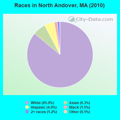
Races in North Andover detailed stats: ancestries, foreign born residents, place of birth
According to our research of Massachusetts and other state lists, there were 8 registered sex offenders living in North Andover, Massachusetts as of May 07, 2024.
The ratio of all residents to sex offenders in North Andover is 3,544 to 1.
The ratio of registered sex offenders to all residents in this city is lower than the state average.
Type |
2009 |
2010 |
2011 |
2012 |
2013 |
2014 |
2015 |
2016 |
2017 |
2018 |
2019 |
2020 |
2021 |
2022 |
|---|---|---|---|---|---|---|---|---|---|---|---|---|---|---|
| Murders (per 100,000) | 0 (0.0) | 0 (0.0) | 0 (0.0) | 0 (0.0) | 0 (0.0) | 0 (0.0) | 3 (10.1) | 0 (0.0) | 0 (0.0) | 1 (3.2) | 0 (0.0) | 0 (0.0) | 0 (0.0) | 0 (0.0) |
| Rapes (per 100,000) | 1 (3.6) | 0 (0.0) | 0 (0.0) | 0 (0.0) | 0 (0.0) | 0 (0.0) | 0 (0.0) | 0 (0.0) | 4 (12.9) | 9 (28.7) | 5 (15.9) | 5 (16.0) | 2 (6.2) | 4 (13.0) |
| Robberies (per 100,000) | 2 (7.1) | 2 (7.1) | 1 (3.5) | 4 (13.9) | 0 (0.0) | 2 (6.8) | 5 (16.8) | 1 (3.3) | 2 (6.4) | 2 (6.4) | 3 (9.5) | 2 (6.4) | 2 (6.2) | 3 (9.8) |
| Assaults (per 100,000) | 5 (17.8) | 5 (17.6) | 9 (31.6) | 11 (38.2) | 10 (34.9) | 6 (20.3) | 12 (40.3) | 11 (36.8) | 23 (74.1) | 23 (73.3) | 10 (31.8) | 22 (70.2) | 14 (43.7) | 21 (68.4) |
| Burglaries (per 100,000) | 37 (131.6) | 48 (169.3) | 43 (150.7) | 40 (138.8) | 26 (90.7) | 24 (81.4) | 25 (84.0) | 11 (36.8) | 19 (61.2) | 10 (31.9) | 14 (44.5) | 3 (9.6) | 15 (46.8) | 22 (71.7) |
| Thefts (per 100,000) | 271 (963.9) | 277 (977.0) | 274 (960.6) | 305 (1,058) | 440 (1,535) | 289 (979.6) | 233 (783.0) | 161 (539.3) | 140 (451.1) | 152 (484.2) | 140 (445.5) | 101 (322.3) | 93 (290.3) | 92 (299.7) |
| Auto thefts (per 100,000) | 10 (35.6) | 13 (45.9) | 13 (45.6) | 8 (27.8) | 13 (45.3) | 5 (16.9) | 12 (40.3) | 7 (23.4) | 9 (29.0) | 12 (38.2) | 10 (31.8) | 3 (9.6) | 8 (25.0) | 15 (48.9) |
| Arson (per 100,000) | 0 (0.0) | 0 (0.0) | 0 (0.0) | 0 (0.0) | 0 (0.0) | 0 (0.0) | 1 (3.4) | 1 (3.3) | 0 (0.0) | 3 (9.6) | 0 (0.0) | 1 (3.2) | 2 (6.2) | 3 (9.8) |
| City-Data.com crime index | 59.1 | 60.2 | 60.0 | 66.1 | 78.3 | 52.3 | 73.7 | 34.4 | 51.7 | 70.5 | 45.4 | 43.0 | 32.5 | 48.0 |
The City-Data.com crime index weighs serious crimes and violent crimes more heavily. Higher means more crime, U.S. average is 246.1. It adjusts for the number of visitors and daily workers commuting into cities.
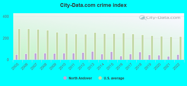
Crime rate in North Andover detailed stats: murders, rapes, robberies, assaults, burglaries, thefts, arson
Full-time law enforcement employees in 2021, including police officers: 57 (42 officers - 39 male; 3 female).
| Officers per 1,000 residents here: | 1.31 |
| Massachusetts average: | 2.53 |
 Recent articles from our blog. Our writers, many of them Ph.D. graduates or candidates, create easy-to-read articles on a wide variety of topics.

 | 50 migrants relocated to Martha's Vineyard by Florida Gov. Ron DeSantis (909 replies) |
| Custom builders for Andover/North Andover (5 replies) |
| Towns within 495 with nice walkable downtowns and good schools (205 replies) |
| Boston Racial Stigma- is it "cool" to hate on Boston? (632 replies) |
| North Reading today - the good and the bad (125 replies) |
| Pick a New England place for us (62 replies) |
Latest news from North Andover, MA collected exclusively by city-data.com from local newspapers, TV, and radio stations
North Andover, MA City Guides:
Ancestries: Irish (30.4%), Italian (19.8%), English (16.4%), German (8.3%), French (7.8%), Polish (4.5%).
Current Local Time: EST time zone
Incorporated in 1855
Elevation: 75 feet
Land area: 26.7 square miles.
Population density: 1,064 people per square mile (low).
2,191 residents are foreign born (3.3% Asia, 3.1% Europe, 0.8% Latin America).
| This town: | 8.1% |
| Massachusetts: | 12.2% |
| North Andover town: | 1.2% ($3,372) |
| Massachusetts: | 1.3% ($2,336) |
Nearest city with pop. 50,000+: Lawrence, MA  (2.9 miles , pop. 72,043).
Nearest city with pop. 200,000+: Boston, MA (25.1 miles , pop. 589,141).
Nearest city with pop. 1,000,000+: Bronx, NY (190.9 miles , pop. 1,332,650).
Nearest cities:
), )Latitude: 42.68 N, Longitude: 71.11 W
Area code commonly used in this area: 978

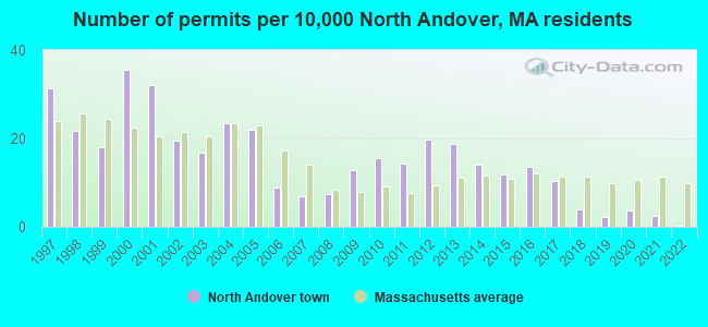
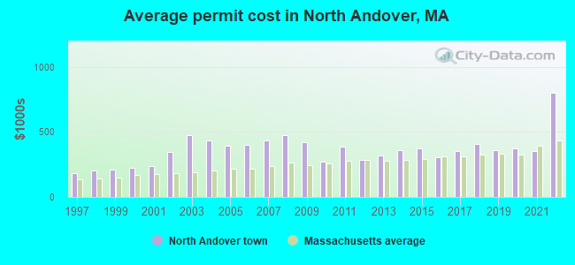
Single-family new house construction building permits:
- 2022: 1 building, cost: $800,000
- 2021: 7 buildings, average cost: $354,300
- 2020: 10 buildings, average cost: $371,900
- 2019: 6 buildings, average cost: $362,400
- 2018: 11 buildings, average cost: $406,600
- 2017: 28 buildings, average cost: $351,400
- 2016: 37 buildings, average cost: $301,500
- 2015: 32 buildings, average cost: $370,200
- 2014: 38 buildings, average cost: $358,300
- 2013: 51 buildings, average cost: $319,700
- 2012: 54 buildings, average cost: $282,700
- 2011: 39 buildings, average cost: $388,400
- 2010: 42 buildings, average cost: $269,500
- 2009: 35 buildings, average cost: $418,300
- 2008: 20 buildings, average cost: $471,600
- 2007: 19 buildings, average cost: $431,400
- 2006: 24 buildings, average cost: $397,900
- 2005: 60 buildings, average cost: $394,300
- 2004: 64 buildings, average cost: $433,200
- 2003: 46 buildings, average cost: $474,000
- 2002: 53 buildings, average cost: $343,200
- 2001: 87 buildings, average cost: $240,400
- 2000: 97 buildings, average cost: $226,000
- 1999: 49 buildings, average cost: $211,000
- 1998: 59 buildings, average cost: $203,400
- 1997: 85 buildings, average cost: $183,700
| Here: | 3.1% |
| Massachusetts: | 3.5% |
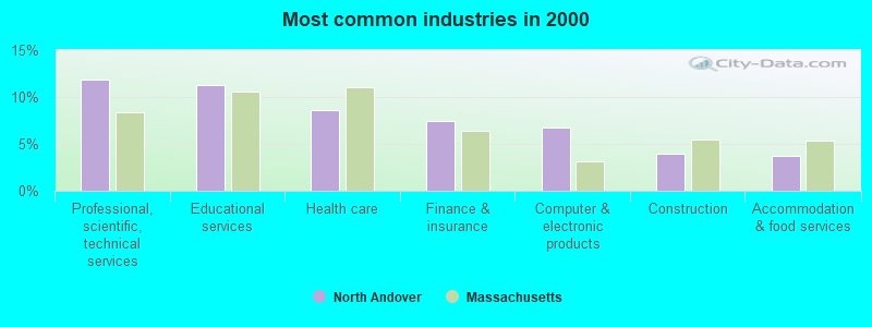
- Professional, scientific, technical services (11.9%)
- Educational services (11.3%)
- Health care (8.6%)
- Finance & insurance (7.4%)
- Computer & electronic products (6.8%)
- Construction (3.9%)
- Accommodation & food services (3.7%)
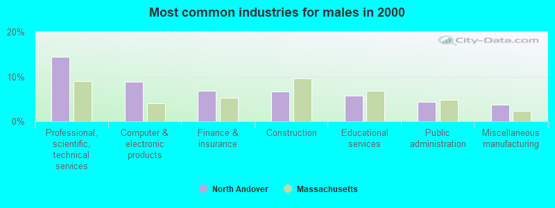
- Professional, scientific, technical services (14.4%)
- Computer & electronic products (8.8%)
- Finance & insurance (6.8%)
- Construction (6.7%)
- Educational services (5.8%)
- Public administration (4.3%)
- Miscellaneous manufacturing (3.7%)
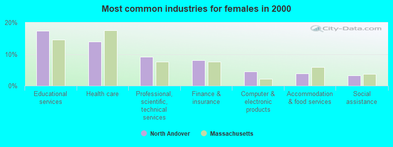
- Educational services (17.4%)
- Health care (14.0%)
- Professional, scientific, technical services (9.1%)
- Finance & insurance (8.0%)
- Computer & electronic products (4.5%)
- Accommodation & food services (3.9%)
- Social assistance (3.2%)
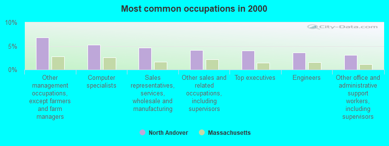
- Other management occupations, except farmers and farm managers (6.8%)
- Computer specialists (5.2%)
- Sales representatives, services, wholesale and manufacturing (4.6%)
- Other sales and related occupations, including supervisors (4.2%)
- Top executives (4.0%)
- Engineers (3.6%)
- Other office and administrative support workers, including supervisors (3.1%)
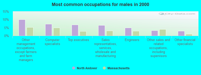
- Other management occupations, except farmers and farm managers (10.1%)
- Computer specialists (7.3%)
- Top executives (6.8%)
- Sales representatives, services, wholesale and manufacturing (6.5%)
- Engineers (5.0%)
- Other sales and related occupations, including supervisors (3.3%)
- Other financial specialists (2.9%)

- Preschool, kindergarten, elementary, and middle school teachers (5.9%)
- Secretaries and administrative assistants (5.7%)
- Other sales and related occupations, including supervisors (5.1%)
- Other office and administrative support workers, including supervisors (5.0%)
- Registered nurses (4.8%)
- Information and record clerks, except customer service representatives (3.7%)
- Other management occupations, except farmers and farm managers (3.2%)
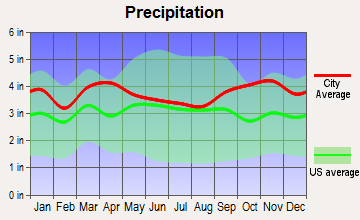
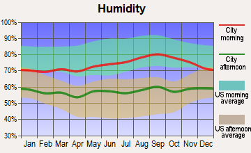
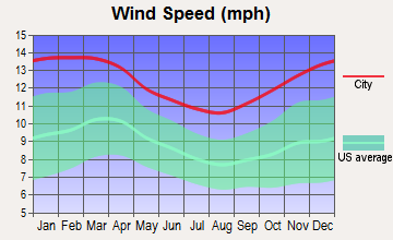
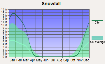
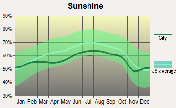
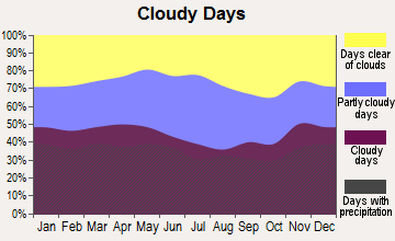
Average climate in North Andover, Massachusetts
Based on data reported by over 4,000 weather stations

(lower is better)
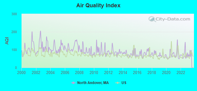
Air Quality Index (AQI) level in 2022 was 74.3. This is about average.
| City: | 74.3 |
| U.S.: | 72.6 |
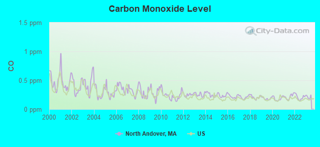
Carbon Monoxide (CO) [ppm] level in 2022 was 0.208. This is better than average. Closest monitor was 7.6 miles away from the city center.
| City: | 0.208 |
| U.S.: | 0.251 |
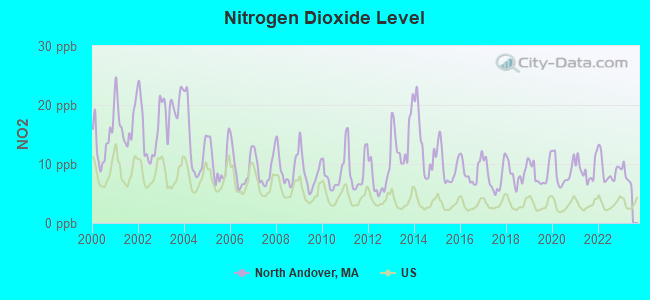
Nitrogen Dioxide (NO2) [ppb] level in 2022 was 8.96. This is significantly worse than average. Closest monitor was 2.1 miles away from the city center.
| City: | 8.96 |
| U.S.: | 5.11 |
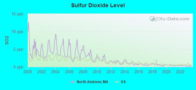
Sulfur Dioxide (SO2) [ppb] level in 2022 was 0.346. This is significantly better than average. Closest monitor was 2.1 miles away from the city center.
| City: | 0.346 |
| U.S.: | 1.515 |
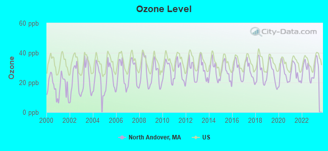
Ozone [ppb] level in 2022 was 27.8. This is about average. Closest monitor was 2.5 miles away from the city center.
| City: | 27.8 |
| U.S.: | 33.3 |
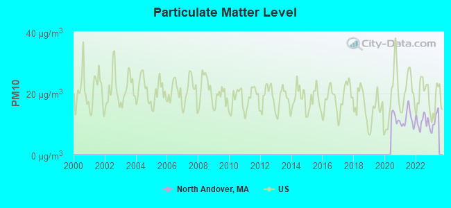
Particulate Matter (PM10) [µg/m3] level in 2022 was 10.6. This is significantly better than average. Closest monitor was 2.5 miles away from the city center.
| City: | 10.6 |
| U.S.: | 19.2 |
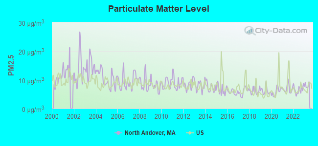
Particulate Matter (PM2.5) [µg/m3] level in 2022 was 6.63. This is better than average. Closest monitor was 2.9 miles away from the city center.
| City: | 6.63 |
| U.S.: | 8.11 |
Tornado activity:
North Andover-area historical tornado activity is near Massachusetts state average. It is 41% smaller than the overall U.S. average.
On 9/29/1974, a category F3 (max. wind speeds 158-206 mph) tornado 6.3 miles away from the North Andover town center injured one person and caused between $50,000 and $500,000 in damages.
On 6/9/1953, a category F4 (max. wind speeds 207-260 mph) tornado 33.7 miles away from the town center killed 90 people and injured 1228 people and caused between $50,000,000 and $500,000,000 in damages.
Earthquake activity:
North Andover-area historical earthquake activity is significantly above Massachusetts state average. It is 73% smaller than the overall U.S. average.On 4/20/2002 at 10:50:47, a magnitude 5.3 (5.3 ML, Depth: 3.0 mi, Class: Moderate, Intensity: VI - VII) earthquake occurred 181.0 miles away from the city center
On 10/7/1983 at 10:18:46, a magnitude 5.3 (5.1 MB, 5.3 LG, 5.1 ML) earthquake occurred 184.7 miles away from the city center
On 1/19/1982 at 00:14:42, a magnitude 4.7 (4.5 MB, 4.7 MD, 4.5 LG, Class: Light, Intensity: IV - V) earthquake occurred 61.6 miles away from North Andover center
On 10/16/2012 at 23:12:25, a magnitude 4.7 (4.7 ML, Depth: 10.0 mi) earthquake occurred 67.2 miles away from the city center
On 4/20/2002 at 10:50:47, a magnitude 5.2 (5.2 MB, 4.2 MS, 5.2 MW, 5.0 MW) earthquake occurred 180.6 miles away from North Andover center
On 8/22/1992 at 12:20:32, a magnitude 4.8 (4.8 MB, 3.8 MS, 4.7 LG, Depth: 6.2 mi) earthquake occurred 250.9 miles away from North Andover center
Magnitude types: regional Lg-wave magnitude (LG), body-wave magnitude (MB), duration magnitude (MD), local magnitude (ML), surface-wave magnitude (MS), moment magnitude (MW)
Natural disasters:
The number of natural disasters in Essex County (33) is a lot greater than the US average (15).Major Disasters (Presidential) Declared: 20
Emergencies Declared: 13
Causes of natural disasters: Floods: 14, Storms: 11, Hurricanes: 6, Snowstorms: 5, Winter Storms: 5, Snows: 3, Blizzards: 2, Fire: 1, Heavy Rain: 1, Snowfall: 1, Water Main Break: 1, Wind: 1 (Note: some incidents may be assigned to more than one category).

Main business address for: WATTS WATER TECHNOLOGIES INC (MISCELLANEOUS FABRICATED METAL PRODUCTS), ERGO SCIENCE CORP /DE/ (OPERATIVE BUILDERS), LSB CORP (NATIONAL COMMERCIAL BANKS).
Hospitals and medical centers in North Andover:
Operable nuclear power plant near North Andover:
- 20 miles: Seabrook in Seabrook, NH.
Colleges/Universities in North Andover:
- Merrimack College (Full-time enrollment: 2,734; Location: 315 Turnpike St; Private, not-for-profit; Website: www.merrimack.edu; Offers Master's degree)
- New England Tractor Trailer Training School of Massachusetts (Full-time enrollment: 296; Location: 1600 Osgood Street; Private, for-profit; Website: www.nettts.com)
Other colleges/universities with over 2000 students near North Andover:
- Northern Essex Community College (about 9 miles; Haverhill, MA; Full-time enrollment: 4,737)
- North Shore Community College (about 10 miles; Danvers, MA; FT enrollment: 5,195)
- University of Massachusetts-Lowell (about 12 miles; Lowell, MA; FT enrollment: 12,341)
- Middlesex Community College (about 14 miles; Bedford, MA; FT enrollment: 6,040)
- Endicott College (about 17 miles; Beverly, MA; FT enrollment: 4,064)
- Salem State University (about 17 miles; Salem, MA; FT enrollment: 8,027)
- Tufts University (about 20 miles; Medford, MA; FT enrollment: 9,041)
Public high school in North Andover:
- NORTH ANDOVER HIGH (Students: 1,371, Location: 430 OSGOOD STREET, Grades: 9-12)
Public elementary/middle schools in North Andover:
- ANNIE L SARGENT SCHOOL (Students: 631, Location: 300 ABBOTT STREET, Grades: KG-5)
- FRANKLIN (Students: 506, Location: 2 CYPRESS TERRACE, Grades: KG-5)
- THOMSON (Students: 400, Location: 266 WAVERLY RD, Grades: KG-5)
- ATKINSON (Students: 346, Location: 111 PHILLIPS BRKS RD, Grades: PK-5)
- KITTREDGE (Students: 270, Location: 601 MAIN STREET, Grades: KG-5)
- NORTH ANDOVER MIDDLE (Students: 11, Location: 495 MAIN STREET, Grades: 6-8)
Private elementary/middle schools in North Andover:
Library in North Andover:
Points of interest:
Notable locations in North Andover: Boston Hill Ski Area (A), Smolak Farm (B), North Andover Plaza (C), Marble Ridge Station (D), North Andover Fire Department Station 2 (E), Atkinson Elementary School Library (F), North Andover Fire Department Station 1 Headquarters (G). Display/hide their locations on the map
Shopping Centers: North Andover Mall (1), Spree Shopping Center (2). Display/hide their locations on the map
Main business address in North Andover include: WATTS WATER TECHNOLOGIES INC (A), ERGO SCIENCE CORP /DE/ (B), LSB CORP (C). Display/hide their locations on the map
Church in North Andover: First Calvary Baptist Church (A). Display/hide its location on the map
Cemeteries: First Burying Ground (1), Holy Sepulchre Cemetery (2), Ridgewood Cemetery (3). Display/hide their locations on the map
Lakes and reservoirs: Lake Cochichewick (A), Sharpners Pond (B), Stevens Pond (C), Berry Pond (D), Salem Pond (E), Stearns Pond (F), Sudden Pond (G), Osgood Pond (H). Display/hide their locations on the map
Streams, rivers, and creeks: Mosquito Brook (A), Shawsheen River (B), Cochichewick River (C). Display/hide their locations on the map
Tourist attraction: Museum of Printing (Cultural Attractions- Events- & Facilities; 800 Massachusetts Avenue) (1). Display/hide its approximate location on the map
Hotel: Order In The House (225 Carlton Ln) (1). Display/hide its approximate location on the map
Birthplace of: Isaac Stevens - Union Army general, Cliff Bleszinski - Video game designer, George B. Loring - Politician, Samuel Phillips, Jr. - Massachusetts lieutenant governor, Jamie Hagerman - Ice hockey player, George Glennie - Football player, Harry Macpherson - Baseball player.
Drinking water stations with addresses in North Andover and their reported violations in the past:
WIND IN THE PINES (Population served: 220, Groundwater):Past monitoring violations:
- One routine major monitoring violation
- One minor monitoring violation
Drinking water stations with addresses in North Andover that have no violations reported:
- NORTH ANDOVER WATER DEPT (Population served: 27,985, Primary Water Source Type: Surface water)
- BOULDER BROOK CLUB (Serves ME, Population served: 53, Primary Water Source Type: Groundwater)
| This town: | 2.6 people |
| Massachusetts: | 2.5 people |
| This town: | 69.6% |
| Whole state: | 63.0% |
| This town: | 5.1% |
| Whole state: | 7.0% |
Likely homosexual households (counted as self-reported same-sex unmarried-partner households)
- Lesbian couples: 0.5% of all households
- Gay men: 0.3% of all households
| This town: | 2.9% |
| Whole state: | 9.3% |
| This town: | 1.2% |
| Whole state: | 4.4% |
People in group quarters in North Andover in 2010:
- 502 people in college/university student housing
- 246 people in nursing facilities/skilled-nursing facilities
- 94 people in workers' group living quarters and job corps centers
- 6 people in other noninstitutional facilities
- 3 people in group homes for juveniles (non-correctional)
People in group quarters in North Andover in 2000:
- 1,316 people in college dormitories (includes college quarters off campus)
- 522 people in nursing homes
- 6 people in homes for the mentally retarded
- 5 people in religious group quarters
- 4 people in homes for the physically handicapped
Banks with most branches in North Andover (2011 data):
- Sovereign Bank, National Association: Chickering Road Branch at 555 Chickering Road, branch established on 1972/04/15; North Andover Main Branch at 149 Main Street, branch established on 1954/12/31. Info updated 2012/01/31: Bank assets: $78,146.9 mil, Deposits: $48,042.9 mil, headquarters in Wilmington, DE, positive income, Commercial Lending Specialization, 718 total offices, Holding Company: Banco Santander, S.A.
- Bank of America, National Association: North Andover Branch at 154 Main Street, branch established on 1955/01/14; Edgewood Branch at 575 Osgood Street, branch established on 1997/03/03. Info updated 2009/11/18: Bank assets: $1,451,969.3 mil, Deposits: $1,077,176.8 mil, headquarters in Charlotte, NC, positive income, 5782 total offices, Holding Company: Bank Of America Corporation
- TD Bank, National Association: North Andover Branch at 451 Andover Street, branch established on 1994/10/17; North Andover Branch at 108 Main Street, branch established on 1944/05/01. Info updated 2010/10/04: Bank assets: $188,912.6 mil, Deposits: $153,149.8 mil, headquarters in Wilmington, DE, positive income, 1314 total offices, Holding Company: Toronto-Dominion Bank, The
- People's United Bank: Mass Avenue Branch at 30 Massachusetts Avenue, branch established on 1868/03/10. Info updated 2012/02/16: Bank assets: $27,319.3 mil, Deposits: $20,835.4 mil, headquarters in Bridgeport, CT, positive income, Commercial Lending Specialization, 374 total offices
- Stoneham Savings Bank: North Andover Branch at 601 Chickering Road, branch established on 1997/12/15. Info updated 2012/02/03: Bank assets: $330.8 mil, Deposits: $257.7 mil, headquarters in Stoneham, MA, negative income in the last year, Commercial Lending Specialization, 6 total offices
- RBS Citizens, National Association: North Andover Stop & Shop Branch at 757 Turnpike Street, branch established on 2002/04/03. Info updated 2007/09/19: Bank assets: $106,940.6 mil, Deposits: $75,690.2 mil, headquarters in Providence, RI, positive income, 1135 total offices, Holding Company: Uk Financial Investments Limited
- Northmark Bank: at 89 Turnpike Street, branch established on 1987/12/08. Info updated 2006/11/03: Bank assets: $305.6 mil, Deposits: $261.3 mil, local headquarters, positive income, Commercial Lending Specialization, 3 total offices
- Georgetown Savings Bank: North Andover Branch at 75 Turnpike Road, branch established on 2005/12/05. Info updated 2011/07/21: Bank assets: $199.4 mil, Deposits: $152.6 mil, headquarters in Georgetown, MA, positive income, Commercial Lending Specialization, 3 total offices
- Citibank, National Association: North Andover Branch at 123 Turnpike St, branch established on 2007/12/07. Info updated 2012/01/10: Bank assets: $1,288,658.0 mil, Deposits: $882,541.0 mil, headquarters in Sioux Falls, SD, positive income, International Specialization, 1048 total offices, Holding Company: Citigroup Inc.
For population 15 years and over in North Andover:
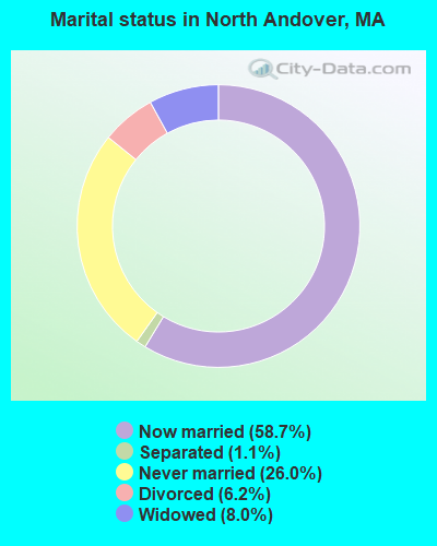
- Never married: 26.0%
- Now married: 58.7%
- Separated: 1.1%
- Widowed: 8.0%
- Divorced: 6.2%
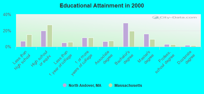
For population 25 years and over in North Andover:
- High school or higher: 93.1%
- Bachelor's degree or higher: 50.3%
- Graduate or professional degree: 20.9%
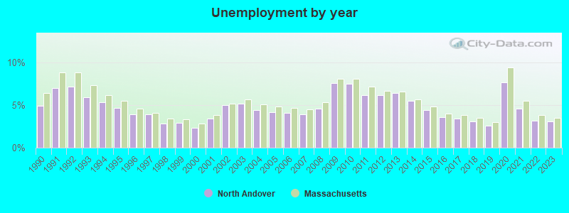
- Unemployed: 2.3%
- Mean travel time to work (commute): 28.8 minutes
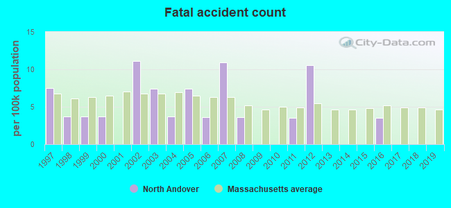
| Here: | 10.5 |
| Massachusetts average: | 13.1 |


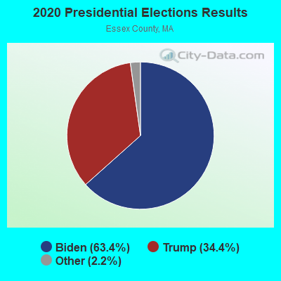
Graphs represent county-level data. Detailed 2008 Election Results
Religion statistics for North Andover, MA (based on Essex County data)


| Religion | Adherents | Congregations |
|---|---|---|
| Catholic | 341,970 | 55 |
| Mainline Protestant | 33,710 | 140 |
| Evangelical Protestant | 20,925 | 160 |
| Other | 15,882 | 63 |
| Orthodox | 11,590 | 13 |
| Black Protestant | 376 | 3 |
| None | 318,706 | - |
Food Environment Statistics:
| This county: | 1.98 / 10,000 pop. |
| Massachusetts: | 1.98 / 10,000 pop. |
| This county: | 0.04 / 10,000 pop. |
| Massachusetts: | 0.05 / 10,000 pop. |
| Essex County: | 1.97 / 10,000 pop. |
| State: | 2.22 / 10,000 pop. |
| Essex County: | 1.30 / 10,000 pop. |
| Massachusetts: | 1.77 / 10,000 pop. |
| Here: | 7.60 / 10,000 pop. |
| Massachusetts: | 8.76 / 10,000 pop. |
| This county: | 8.4% |
| Massachusetts: | 8.1% |
| Essex County: | 23.7% |
| Massachusetts: | 22.5% |
| Essex County: | 20.7% |
| Massachusetts: | 16.5% |
5.09% of this county's 2021 resident taxpayers lived in other counties in 2020 ($96,821 average adjusted gross income)
| Here: | 5.09% |
| Massachusetts average: | 6.35% |
0.01% of residents moved from foreign countries ($21 average AGI)
Essex County: 0.01% Massachusetts average: 0.01%
Top counties from which taxpayers relocated into this county between 2020 and 2021:
| from Middlesex County, MA | |
| from Suffolk County, MA | |
| from Rockingham County, NH |
5.47% of this county's 2020 resident taxpayers moved to other counties in 2021 ($95,440 average adjusted gross income)
| Here: | 5.47% |
| Massachusetts average: | 7.18% |
0.01% of residents moved to foreign countries ($53 average AGI)
Essex County: 0.01% Massachusetts average: 0.02%
Top counties to which taxpayers relocated from this county between 2020 and 2021:
| to Middlesex County, MA | |
| to Rockingham County, NH | |
| to Suffolk County, MA |
| Businesses in North Andover, MA | ||||
| Name | Count | Name | Count | |
|---|---|---|---|---|
| Ace Hardware | 1 | MasterBrand Cabinets | 2 | |
| Blockbuster | 1 | McDonald's | 1 | |
| Burger King | 1 | Panera Bread | 1 | |
| CVS | 2 | Payless | 1 | |
| Chico's | 1 | Penske | 1 | |
| Chipotle | 1 | Pier 1 Imports | 1 | |
| Curves | 1 | Rite Aid | 1 | |
| Dunkin Donuts | 6 | Staples | 1 | |
| Fashion Bug | 1 | Starbucks | 1 | |
| FedEx | 5 | Stop & Shop | 1 | |
| GNC | 1 | T.J.Maxx | 1 | |
| H&R Block | 1 | U-Haul | 1 | |
| J. Jill | 1 | UPS | 7 | |
| JoS. A. Bank | 1 | Walgreens | 1 | |
| Kohl's | 1 | |||
Strongest AM radio stations in North Andover:
- WRKO (680 AM; 50 kW; BOSTON, MA; Owner: ENTERCOM BOSTON LICENSE, LLC)
- WWZN (1510 AM; 50 kW; BOSTON, MA; Owner: ROSE CITY RADIO CORPORATION)
- WNNW (800 AM; 1 kW; LAWRENCE, MA; Owner: COSTA-EAGLE RADIO VENTURES, LP)
- WEEI (850 AM; 50 kW; BOSTON, MA; Owner: ENTERCOM BOSTON LICENSE, LLC)
- WBZ (1030 AM; 50 kW; BOSTON, MA; Owner: INFINITY BROADCASTING OPERATIONS, INC.)
- WCEC (1110 AM; daytime; 5 kW; SALEM, NH; Owner: COSTA-EAGLE RADIO VENTURES LTD PARTNERSHIP)
- WKOX (1200 AM; 50 kW; FRAMINGHAM, MA; Owner: CAPSTAR TX LIMITED PARTNERSHIP)
- WBIX (1060 AM; 40 kW; NATICK, MA; Owner: LANGER BROADCASTING CORPORATION)
- WRCA (1330 AM; 25 kW; WALTHAM, MA; Owner: WRCA LICENSE, LLC)
- WDER (1320 AM; 10 kW; DERRY, NH; Owner: BLOUNT COMMUNICATIONS, INC. OF NH)
- WCAP (980 AM; 5 kW; LOWELL, MA; Owner: NORTHEAST RADIO, INC.)
- WAMG (890 AM; 25 kW; DEDHAM, MA; Owner: MEGA COMMUNICATIONS OF DEDHAM LICENSEE, LLC)
- WCRN (830 AM; 50 kW; WORCESTER, MA; Owner: CARTER BROADCASTING CORPORATION)
Strongest FM radio stations in North Andover:
- WKLB-FM (99.5 FM; LOWELL, MA; Owner: GREATER BOSTON RADIO, INC.)
- WXRV (92.5 FM; HAVERHILL, MA; Owner: BEANPOT BROADCASTING CORP.)
- W227AM (93.3 FM; ANDOVER, MA; Owner: GREATER BOSTON RADIO, INC.)
- WQSX (93.7 FM; LAWRENCE, MA; Owner: ENTERCOM BOSTON LICENSE, LLC)
- WXKS-FM (107.9 FM; MEDFORD, MA; Owner: AMFM RADIO LICENSES, L.L.C.)
- WMJX (106.7 FM; BOSTON, MA; Owner: GREATER BOSTON RADIO, INC.)
- WBMX (98.5 FM; BOSTON, MA; Owner: INFINITY RADIO OPERATIONS INC.)
- WHOB (106.3 FM; NASHUA, NH; Owner: TELE-MEDIA COMPANY OF NEW HAMPSHIRE, L.L.C.)
- WJMN (94.5 FM; BOSTON, MA; Owner: AMFM RADIO LICENSES, L.L.C.)
- WCRB (102.5 FM; WALTHAM, MA; Owner: CHARLES RIVER BROADCASTING WCRB LICE)
- WTKK (96.9 FM; BOSTON, MA; Owner: GREATER BOSTON RADIO, INC.)
- WROR-FM (105.7 FM; FRAMINGHAM, MA; Owner: GREATER BOSTON RADIO, INC.)
- WBOS (92.9 FM; BROOKLINE, MA; Owner: GREATER BOSTON RADIO, INC.)
- WGBH (89.7 FM; BOSTON, MA; Owner: WGBH EDUCATIONAL FOUNDATION)
- WBUR-FM (90.9 FM; BOSTON, MA; Owner: TRUSTEES OF BOSTON UNIVERSITY)
- WBCN (104.1 FM; BOSTON, MA; Owner: HEMISPHERE BROADCASTING CORPORATION)
- WZLX (100.7 FM; BOSTON, MA; Owner: INFINITY BROADCASTING CORPORATION OF BOSTON)
- W267AI (101.3 FM; BOSTON, MA; Owner: MCC BROADCASTING COMPANY, INC.)
- WODS (103.3 FM; BOSTON, MA; Owner: INFINITY BROADCASTING OPERATIONS, INC.)
- WERS (88.9 FM; BOSTON, MA; Owner: EMERSON COLLEGE)
TV broadcast stations around North Andover:
- WFXZ-CA (Channel 24; BOSTON, MA; Owner: BOSTON BROADCASTING CORP.)
- WCVB-TV (Channel 5; BOSTON, MA; Owner: WCVB HEARST-ARGYLE TV, INC.)
- WGBH-TV (Channel 2; BOSTON, MA; Owner: WGBH EDUCATIONAL FOUNDATION)
- WHDH-TV (Channel 7; BOSTON, MA; Owner: WHDH-TV)
- WMFP (Channel 62; LAWRENCE, MA; Owner: WSAH LICENSE, INC.)
- WBZ-TV (Channel 4; BOSTON, MA; Owner: VIACOM INC.)
- WGBX-TV (Channel 44; BOSTON, MA; Owner: WGBH EDUCATIONAL FOUNDATION)
- WSBK-TV (Channel 38; BOSTON, MA; Owner: VIACOM INC.)
- WLVI-TV (Channel 56; CAMBRIDGE, MA; Owner: WLVI, INC.)
- WBPX (Channel 68; BOSTON, MA; Owner: PAXSON BOSTON-68 LICENSE, INC.)
- WHDN-LP (Channel 26; BOSTON, MA; Owner: GUENTER MARKSTEINER)
- WFXT (Channel 25; BOSTON, MA; Owner: FOX TELEVISION STATIONS INC.)
- WUTF (Channel 66; MARLBOROUGH, MA; Owner: TELEFUTURA BOSTON LLC)
- WNDS (Channel 50; DERRY, NH; Owner: CTV OF DERRY, INC)
- WTMU-LP (Channel 32; BOSTON, MA; Owner: ZGS BOSTON, INC.)
- WCEA-LP (Channel 58; BOSTON, MA; Owner: CHANNEL 19 TV CORPORATION)
- W40BO (Channel 40; BOSTON, MA; Owner: PAXSON COMMUNICATIONS LPTV, INC.)
- WUNI (Channel 27; WORCESTER, MA; Owner: ENTRAVISION HOLDINGS, LLC)
- WMEA-TV (Channel 26; BIDDEFORD, ME; Owner: MAINE PUBLIC BROADCASTING CORP.)
- National Bridge Inventory (NBI) Statistics
- 2Number of bridges
- 49ft / 15.1mTotal length
- $20,358,000Total costs
- 126,966Total average daily traffic
- 10,748Total average daily truck traffic
- 168,512Total future (year 2032) average daily traffic
FCC Registered Antenna Towers: 38 (See the full list of FCC Registered Antenna Towers)
FCC Registered Private Land Mobile Towers: 4 (See the full list of FCC Registered Private Land Mobile Towers in North Andover, MA)
FCC Registered Broadcast Land Mobile Towers: 23 (See the full list of FCC Registered Broadcast Land Mobile Towers)
FCC Registered Microwave Towers: 11 (See the full list of FCC Registered Microwave Towers in this town)
FCC Registered Paging Towers: 7 (See the full list of FCC Registered Paging Towers)
FCC Registered Maritime Coast & Aviation Ground Towers: 1 (See the full list of FCC Registered Maritime Coast & Aviation Ground Towers)
FCC Registered Amateur Radio Licenses: 125 (See the full list of FCC Registered Amateur Radio Licenses in North Andover)
FAA Registered Aircraft Manufacturers and Dealers: 4 (See the full list of FAA Registered Manufacturers and Dealers in North Andover)
FAA Registered Aircraft: 28 (See the full list of FAA Registered Aircraft)
2002 - 2018 National Fire Incident Reporting System (NFIRS) incidents
- Fire incident types reported to NFIRS in North Andover, MA
- 1,14661.9%Structure Fires
- 42823.1%Outside Fires
- 1638.8%Mobile Property/Vehicle Fires
- 1146.2%Other
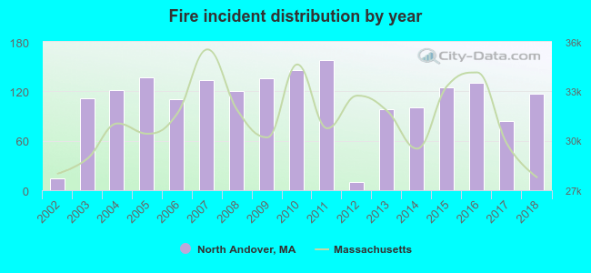 Based on the data from the years 2002 - 2018 the average number of fire incidents per year is 109. The highest number of reported fires - 158 took place in 2011, and the least - 10 in 2012. The data has an increasing trend.
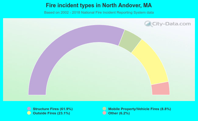 When looking into fire subcategories, the most reports belonged to: Structure Fires (61.9%), and Outside Fires (23.1%).
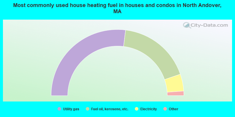
- 53.9%Utility gas
- 35.6%Fuel oil, kerosene, etc.
- 8.3%Electricity
- 1.5%Bottled, tank, or LP gas
- 0.6%Wood
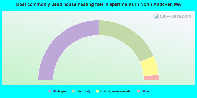
- 50.1%Utility gas
- 36.7%Electricity
- 10.4%Fuel oil, kerosene, etc.
- 2.6%Bottled, tank, or LP gas
- 0.3%Other fuel
North Andover compared to Massachusetts state average:
- Unemployed percentage significantly below state average.
- Black race population percentage significantly below state average.
- Hispanic race population percentage below state average.
- Foreign-born population percentage below state average.
- Length of stay since moving in significantly above state average.
- Number of rooms per house significantly below state average.
- House age significantly below state average.
- Percentage of population with a bachelor's degree or higher above state average.
North Andover on our top lists:
- #10 on the list of "Top 101 cities with largest percentage of females in occupations: engineers (population 5,000+)"
- #29 on the list of "Top 101 cities with the largest racial income disparity between any two races with at least 200 householders"
- #50 on the list of "Top 101 cities with largest percentage of males in industries: computer and electronic products (population 5,000+)"
- #54 on the list of "Top 101 cities with largest percentage of males in industries: miscellaneous manufacturing (population 5,000+)"
- #59 on the list of "Top 101 cities with largest percentage of males in occupations: top executives (population 5,000+)"
- #61 on the list of "Top 101 cities with largest percentage of females in industries: data processing, libraries, and other information services (population 5,000+)"
- #64 on the list of "Top 101 cities with largest percentage of females in occupations: judges, magistrates, and other judicial workers (population 5,000+)"
- #67 on the list of "Top 101 cities with largest percentage of males in occupations: computer specialists (population 5,000+)"
- #73 on the list of "Top 101 cities with largest percentage of females in industries: computer and electronic products (population 5,000+)"
- #74 on the list of "Top 101 cities with largest percentage of males in occupations: sales representatives, services, wholesale and manufacturing (population 5,000+)"
- #82 on the list of "Top 101 cities with largest percentage of males in industries: gasoline stations (population 5,000+)"
- #84 on the list of "Top 101 cities with largest percentage of males in industries: radio, tv, and computer stores (population 5,000+)"
- #85 on the list of "Top 101 cities with largest percentage of females in occupations: electricians (population 5,000+)"
- #85 on the list of "Top 101 cities with largest percentage of females in industries: electrical equipment, appliances, and components (population 5,000+)"
- #88 on the list of "Top 101 cities with largest percentage of females in industries: music stores (population 5,000+)"
- #99 on the list of "Top 101 cities with largest percentage of males in industries: data processing, libraries, and other information services (population 5,000+)"
- #21 on the list of "Top 101 counties with the lowest percentage of residents that keep firearms around their homes"
- #21 on the list of "Top 101 counties with the most Orthodox adherents"
- #23 on the list of "Top 101 counties with the highest carbon monoxide air pollution readings in 2012 (ppm)"
- #30 on the list of "Top 101 counties with the most Catholic adherents"
- #36 on the list of "Top 101 counties with the most Orthodox congregations (pop. 50,000+)"

|
|
Total of 1466 patent applications in 2008-2024.