Las Posas, California
Submit your own pictures of this place and show them to the world
- OSM Map
- General Map
- Google Map
- MSN Map

| Males: 2,080 | |
| Females: 1,965 |
| Median resident age: | 27.1 years |
| California median age: | 33.3 years |
Zip code: 93066
| Las Posas: | $124,344 |
| CA: | $91,551 |
Estimated per capita income in 2022: $59,033 (it was $30,160 in 2000)
Las Posas CCD income, earnings, and wages data
Estimated median house or condo value in 2022: over $1,000,000 (it was $566,900 in 2000)
| Las Posas: | over $1,000,000 |
| CA: | $715,900 |
Mean prices in 2022: all housing units: $901,184; detached houses: $999,306; townhouses or other attached units: $610,170; in 2-unit structures: $496,599; in 3-to-4-unit structures: $548,973; in 5-or-more-unit structures: $472,197; mobile homes: $230,708; occupied boats, rvs, vans, etc.: $13,785
Detailed information about poverty and poor residents in Las Posas, CA


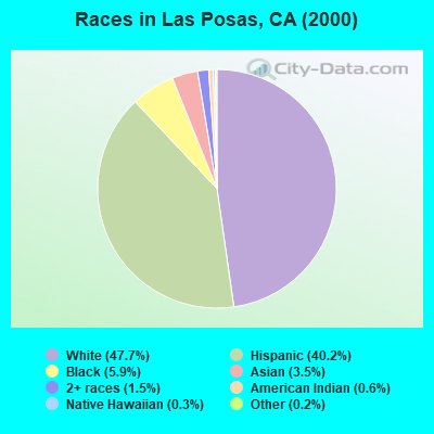
- 1,84947.7%White alone
- 1,55940.2%Hispanic
- 2295.9%Black alone
- 1353.5%Asian alone
- 601.5%Two or more races
- 230.6%American Indian alone
- 110.3%Native Hawaiian and Other
Pacific Islander alone - 90.2%Other race alone
 Recent articles from our blog. Our writers, many of them Ph.D. graduates or candidates, create easy-to-read articles on a wide variety of topics.
Current Local Time: PST time zone
Land area: 53.6 square miles.
Population density: 75 people per square mile (very low).
| Las Posas CCD: | 0.5% ($2,842) |
| California: | 0.8% ($1,564) |
Nearest city with pop. 50,000+: Camarillo, CA  (4.7 miles , pop. 57,077).
Nearest city with pop. 200,000+: Los Angeles, CA (38.3 miles , pop. 3,694,820).
Nearest cities:
), ), ), Latitude: 34.29 N, Longitude: 119.00 W
Area code commonly used in this area: 805

| Here: | 4.7% |
| California: | 5.1% |
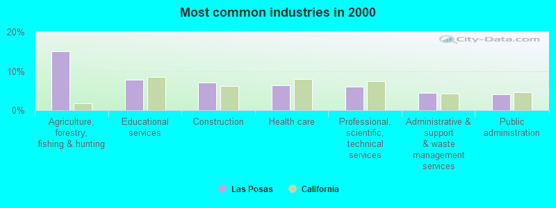
- Agriculture, forestry, fishing & hunting (15.0%)
- Educational services (7.8%)
- Construction (7.1%)
- Health care (6.3%)
- Professional, scientific, technical services (6.0%)
- Administrative & support & waste management services (4.5%)
- Public administration (4.0%)
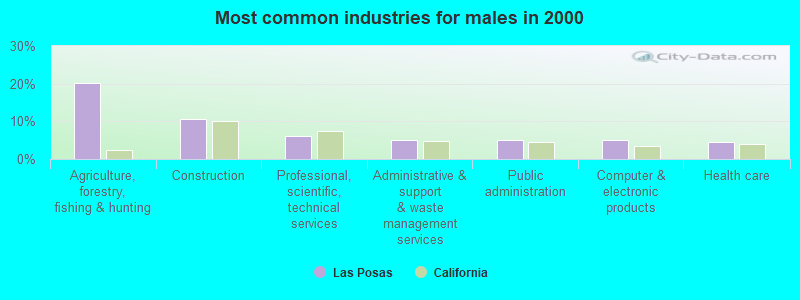
- Agriculture, forestry, fishing & hunting (20.3%)
- Construction (10.7%)
- Professional, scientific, technical services (6.1%)
- Administrative & support & waste management services (5.2%)
- Public administration (4.9%)
- Computer & electronic products (4.9%)
- Health care (4.6%)
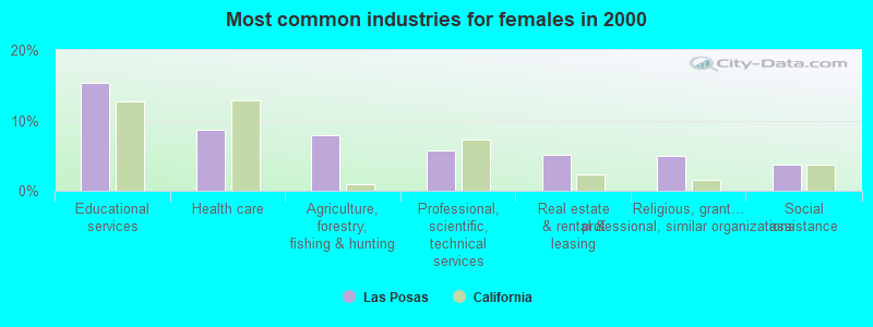
- Educational services (15.4%)
- Health care (8.7%)
- Agriculture, forestry, fishing & hunting (7.9%)
- Professional, scientific, technical services (5.8%)
- Real estate & rental & leasing (5.1%)
- Religious, grantmaking, civic, professional, similar organizations (5.0%)
- Social assistance (3.7%)
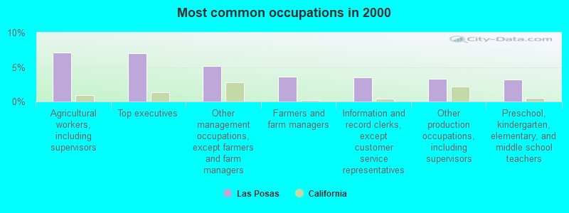
- Agricultural workers, including supervisors (7.1%)
- Top executives (7.0%)
- Other management occupations, except farmers and farm managers (5.1%)
- Farmers and farm managers (3.6%)
- Information and record clerks, except customer service representatives (3.5%)
- Other production occupations, including supervisors (3.3%)
- Preschool, kindergarten, elementary, and middle school teachers (3.2%)
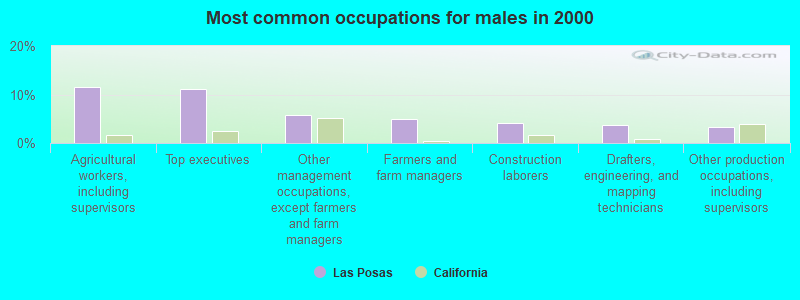
- Agricultural workers, including supervisors (11.6%)
- Top executives (11.0%)
- Other management occupations, except farmers and farm managers (5.8%)
- Farmers and farm managers (5.0%)
- Construction laborers (4.2%)
- Drafters, engineering, and mapping technicians (3.7%)
- Other production occupations, including supervisors (3.4%)
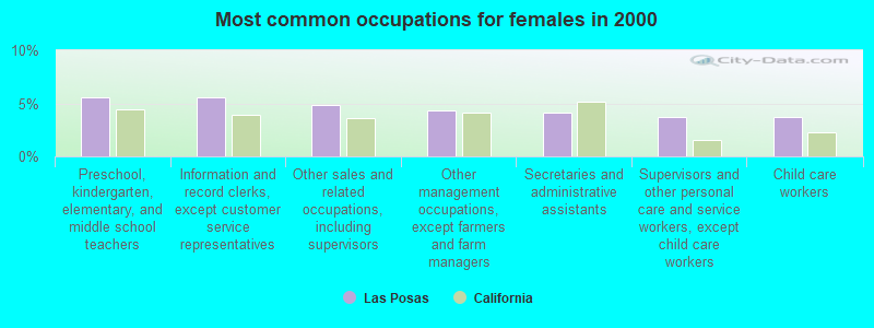
- Preschool, kindergarten, elementary, and middle school teachers (5.6%)
- Information and record clerks, except customer service representatives (5.6%)
- Other sales and related occupations, including supervisors (4.8%)
- Other management occupations, except farmers and farm managers (4.3%)
- Secretaries and administrative assistants (4.2%)
- Supervisors and other personal care and service workers, except child care workers (3.7%)
- Child care workers (3.7%)
Average climate in Las Posas, California
Based on data reported by over 4,000 weather stations


(lower is better)
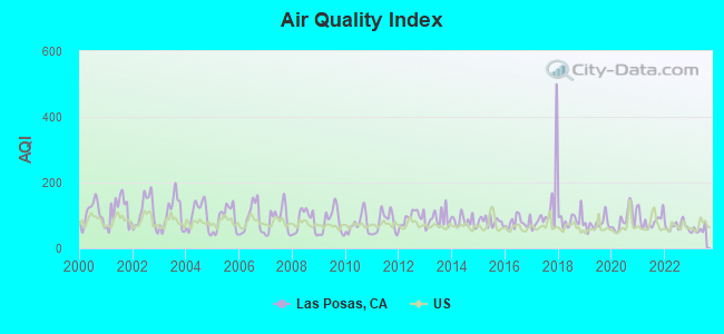
Air Quality Index (AQI) level in 2023 was 56.6. This is better than average.
| City: | 56.6 |
| U.S.: | 72.6 |
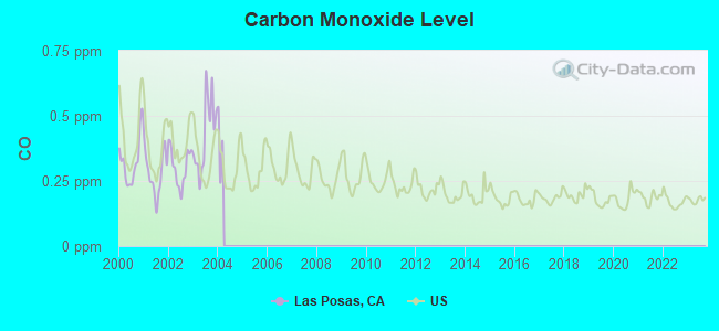
Carbon Monoxide (CO) [ppm] level in 2003 was 0.429. This is significantly worse than average. Closest monitor was 5.5 miles away from the city center.
| City: | 0.429 |
| U.S.: | 0.251 |
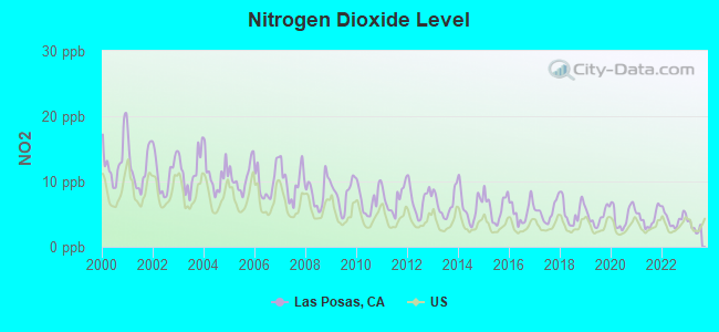
Nitrogen Dioxide (NO2) [ppb] level in 2023 was 3.05. This is significantly better than average. Closest monitor was 5.5 miles away from the city center.
| City: | 3.05 |
| U.S.: | 5.11 |
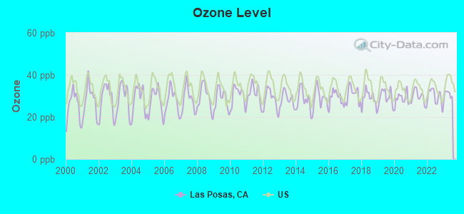
Ozone [ppb] level in 2023 was 30.7. This is about average. Closest monitor was 5.5 miles away from the city center.
| City: | 30.7 |
| U.S.: | 33.3 |
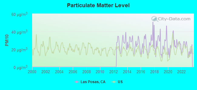
Particulate Matter (PM10) [µg/m3] level in 2023 was 17.6. This is about average. Closest monitor was 8.6 miles away from the city center.
| City: | 17.6 |
| U.S.: | 19.2 |
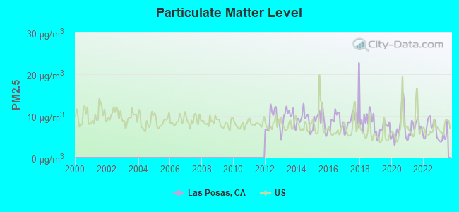
Particulate Matter (PM2.5) [µg/m3] level in 2023 was 5.21. This is significantly better than average. Closest monitor was 8.6 miles away from the city center.
| City: | 5.21 |
| U.S.: | 8.11 |
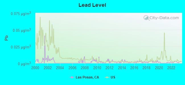
Lead (Pb) [µg/m3] level in 2023 was 0.00179. This is significantly better than average. Closest monitor was 5.5 miles away from the city center.
| City: | 0.00179 |
| U.S.: | 0.00931 |
Earthquake activity:
Las Posas-area historical earthquake activity is significantly above California state average. It is 6847% greater than the overall U.S. average.On 7/21/1952 at 11:52:14, a magnitude 7.7 (7.7 UK, Class: Major, Intensity: VIII - XII) earthquake occurred 49.2 miles away from the city center, causing $50,000,000 total damage
On 6/28/1992 at 11:57:34, a magnitude 7.6 (6.2 MB, 7.6 MS, 7.3 MW, Depth: 0.7 mi) earthquake occurred 141.3 miles away from the city center, causing 3 deaths (1 shaking deaths, 2 other deaths) and 400 injuries, causing $100,000,000 total damage and $40,000,000 insured losses
On 11/4/1927 at 13:51:53, a magnitude 7.5 (7.5 UK) earthquake occurred 123.5 miles away from the city center
On 10/16/1999 at 09:46:44, a magnitude 7.4 (6.3 MB, 7.4 MS, 7.2 MW, 7.3 ML) earthquake occurred 147.2 miles away from Las Posas center
On 1/17/1994 at 12:30:55, a magnitude 6.8 (6.4 MB, 6.8 MS, 6.7 MW, Depth: 11.4 mi, Class: Strong, Intensity: VII - IX) earthquake occurred 26.0 miles away from the city center, causing 60 deaths (60 shaking deaths) and 7000 injuries
On 4/18/1906 at 13:12:21, a magnitude 7.9 (7.9 UK) earthquake occurred 340.3 miles away from Las Posas center, causing $524,000,000 total damage
Magnitude types: body-wave magnitude (MB), local magnitude (ML), surface-wave magnitude (MS), moment magnitude (MW)
Natural disasters:
The number of natural disasters in Ventura County (36) is a lot greater than the US average (15).Major Disasters (Presidential) Declared: 24
Emergencies Declared: 2
Causes of natural disasters: Fires: 17, Floods: 16, Storms: 10, Landslides: 5, Mudslides: 4, Winter Storms: 4, Freezes: 2, Heavy Rains: 2, Earthquake: 1, Hurricane: 1, Snow: 1, Tornado: 1, Wind: 1, Other: 1 (Note: some incidents may be assigned to more than one category).
Hospitals and medical centers near Las Posas:
- FMC-CAMARILLO DIALYSIS CENTER (Dialysis Facility, about 4 miles away; CAMARILLO, CA)
- ST JOHNS PLEASANT VALLEY HOSPITAL Acute Care Hospitals (about 4 miles away; CAMARILLO, CA)
- DAVITA-DIALYSIS CENTER OF CAMARILLO (Dialysis Facility, about 4 miles away; CAMARILLO, CA)
- CAMARILLO STATE HOSP AND DEV CENTER (Nursing Home, about 4 miles away; CAMARILLO, CA)
- BRIGHTON GARDENS OF CAMARILLO (Nursing Home, about 5 miles away; CAMARILLO, CA)
- LAS POSAS HOME HEALTH SERVICES (Home Health Center, about 5 miles away; CAMARILLO, CA)
- FMC-SANTA PAULA (Dialysis Facility, about 6 miles away; SANTA PAULA, CA)
Amtrak stations near Las Posas:
- 6 miles: CAMARILLO (30 LEWIS RD.) . Services: public payphones, public transit connection.
- 6 miles: SANTA PAULA (245 S. PALM AVE.) - Bus Station . Services: fully wheelchair accessible, public payphones, full-service food facilities, public transit connection.
- 8 miles: MOORPARK (300 HIGH ST.) . Services: free short-term parking, public transit connection.
Colleges/universities with over 2000 students nearest to Las Posas:
- California Lutheran University (about 9 miles; Thousand Oaks, CA; Full-time enrollment: 4,103)
- California State University-Channel Islands (about 10 miles; Camarillo, CA; FT enrollment: 4,163)
- Moorpark College (about 10 miles; Moorpark, CA; FT enrollment: 9,338)
- Oxnard College (about 13 miles; Oxnard, CA; FT enrollment: 3,879)
- Ventura College (about 14 miles; Ventura, CA; FT enrollment: 8,460)
- Pepperdine University (about 24 miles; Malibu, CA; FT enrollment: 6,722)
- Los Angeles Pierce College (about 26 miles; Woodland Hills, CA; FT enrollment: 10,996)
Points of interest:
Notable locations in Las Posas: Moorpark Wastewater Treatment Plant (A), Cabrillo Racquet Club (B), Frietas Ranch (C), King Ranch (D), Saticoy Country Club (E). Display/hide their locations on the map
| This place: | 3.2 people |
| California: | 2.9 people |
| This place: | 81.2% |
| Whole state: | 68.7% |
| This place: | 4.8% |
| Whole state: | 7.2% |
Likely homosexual households (counted as self-reported same-sex unmarried-partner households)
- Lesbian couples: 0.7% of all households
- Gay men: 0.5% of all households
| This place: | 13.6% |
| Whole state: | 14.2% |
| This place: | 3.6% |
| Whole state: | 6.3% |
730 people in state prisons in 2000
For population 15 years and over in Las Posas:
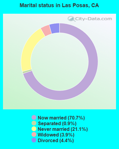
- Never married: 21.1%
- Now married: 70.7%
- Separated: 0.9%
- Widowed: 3.9%
- Divorced: 4.4%
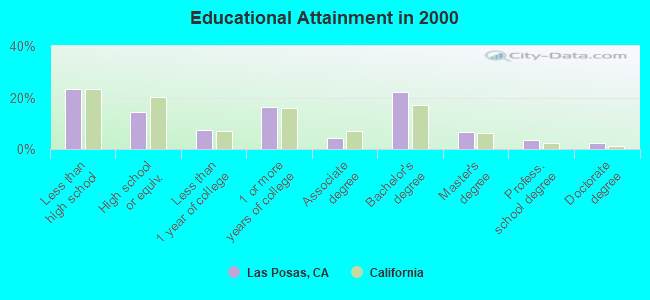
For population 25 years and over in Las Posas:
- High school or higher: 76.5%
- Bachelor's degree or higher: 34.5%
- Graduate or professional degree: 12.4%
- Unemployed: 3.6%
- Mean travel time to work (commute): 20.8 minutes
| Here: | 17.2 |
| California average: | 16.1 |
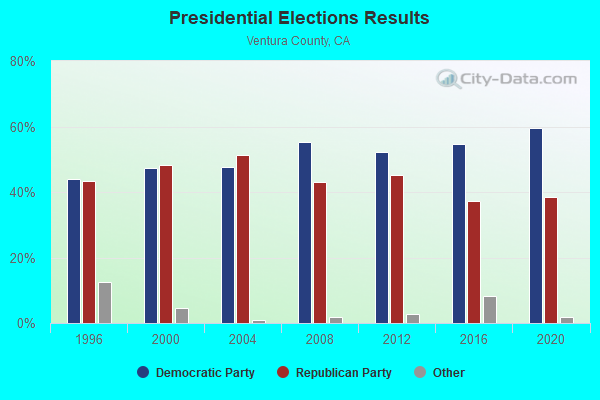
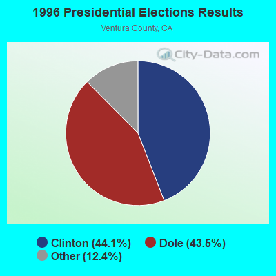
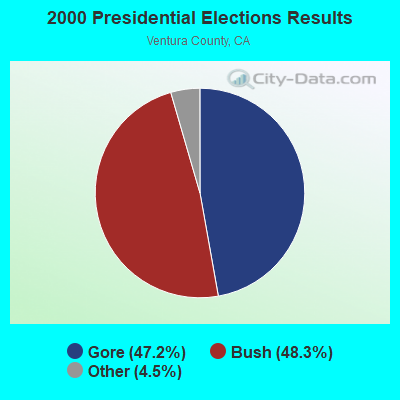
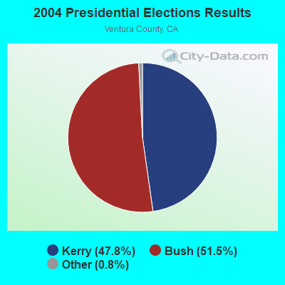
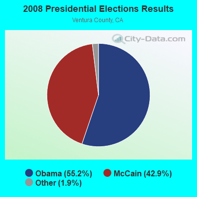
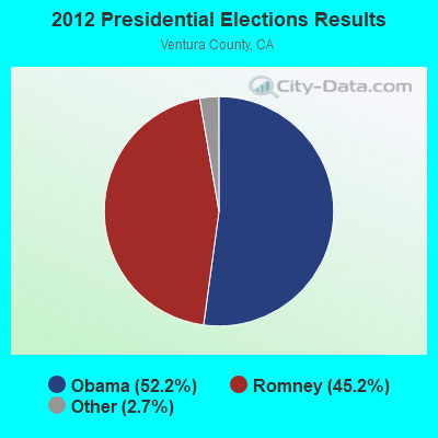
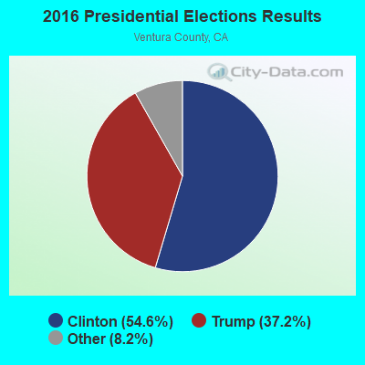
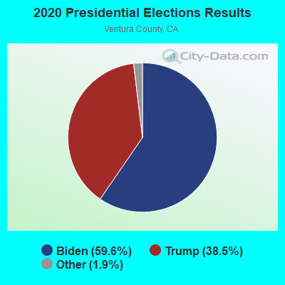
Graphs represent county-level data. Detailed 2008 Election Results
Religion statistics for Las Posas, CA (based on Ventura County data)
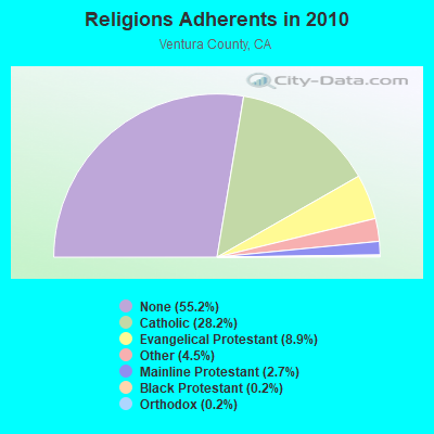
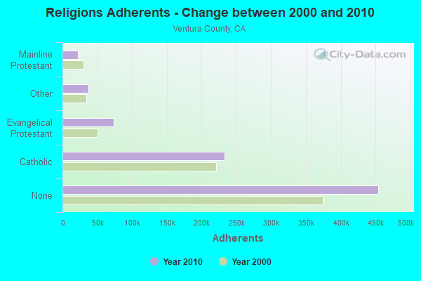
| Religion | Adherents | Congregations |
|---|---|---|
| Catholic | 232,571 | 20 |
| Evangelical Protestant | 73,341 | 268 |
| Other | 37,398 | 118 |
| Mainline Protestant | 22,006 | 65 |
| Black Protestant | 1,986 | 4 |
| Orthodox | 1,680 | 7 |
| None | 454,336 | - |
Food Environment Statistics:
| This county: | 1.97 / 10,000 pop. |
| State: | 2.14 / 10,000 pop. |
| This county: | 0.05 / 10,000 pop. |
| California: | 0.04 / 10,000 pop. |
| Here: | 0.57 / 10,000 pop. |
| California: | 0.62 / 10,000 pop. |
| Ventura County: | 1.69 / 10,000 pop. |
| State: | 1.49 / 10,000 pop. |
| Ventura County: | 7.28 / 10,000 pop. |
| California: | 7.42 / 10,000 pop. |
| Here: | 7.4% |
| California: | 7.3% |
| Ventura County: | 23.1% |
| California: | 21.3% |
| This county: | 19.0% |
| California: | 17.9% |
4.96% of this county's 2021 resident taxpayers lived in other counties in 2020 ($110,211 average adjusted gross income)
| Here: | 4.96% |
| California average: | 5.19% |
0.03% of residents moved from foreign countries ($345 average AGI)
Ventura County: 0.03% California average: 0.03%
Top counties from which taxpayers relocated into this county between 2020 and 2021:
| from Los Angeles County, CA | |
| from Santa Barbara County, CA | |
| from Orange County, CA |
5.51% of this county's 2020 resident taxpayers moved to other counties in 2021 ($95,405 average adjusted gross income)
| Here: | 5.51% |
| California average: | 6.14% |
0.02% of residents moved to foreign countries ($247 average AGI)
Ventura County: 0.02% California average: 0.02%
Top counties to which taxpayers relocated from this county between 2020 and 2021:
| to Los Angeles County, CA | |
| to San Diego County, CA | |
| to Santa Barbara County, CA |
Strongest AM radio stations in Las Posas:
- KACD (850 AM; 25 kW; THOUSAND OAKS, CA; Owner: CITICASTERS LICENSES, L.P.)
- KOXR (910 AM; 5 kW; OXNARD, CA; Owner: LAZER BROADCASTING CORPORATION)
- KSPN (710 AM; 50 kW; LOS ANGELES, CA; Owner: KABC-AM RADIO, INC.)
- KVTA (1520 AM; 10 kW; PORT HUENEME, CA; Owner: GOLD COAST BROADCASTING LLC)
- KLAC (570 AM; 50 kW; LOS ANGELES, CA; Owner: AMFM RADIO LICENSES, L.L.C.)
- KUNX (1590 AM; 5 kW; VENTURA, CA; Owner: GOLD COAST BROADCASTING LLC)
- KFWB (980 AM; 50 kW; LOS ANGELES, CA; Owner: INFINITY BROADCASTING OPERATIONS, INC.)
- KIRN (670 AM; 35 kW; SIMI VALLEY, CA; Owner: LOTUS OXNARD CORP.)
- KNX (1070 AM; 50 kW; LOS ANGELES, CA; Owner: INFINITY BROADCASTING OPERATIONS, INC.)
- KSUR (1260 AM; 25 kW; BEVERLY HILLS, CA)
- KKZZ (1400 AM; 1 kW; SANTA PAULA, CA; Owner: GOLD COAST BROADCASTING LLC)
- KFI (640 AM; 50 kW; LOS ANGELES, CA; Owner: CAPSTAR TX LIMITED PARTNERSHIP)
- KBLA (1580 AM; 50 kW; SANTA MONICA, CA)
Strongest FM radio stations in Las Posas:
- K272DI (102.3 FM; FILLMORE, CA; Owner: SANTA MONICA COMMUNITY COLLEGE DIST.)
- KCZN (96.7 FM; SANTA PAULA, CA; Owner: LAZER BROADCASTING CORPORATION)
- KCLU (88.3 FM; THOUSAND OAKS, CA; Owner: CALIFORNIA LUTHERAN UNIVERSITY)
- KSSC (107.1 FM; VENTURA, CA; Owner: ENTRAVISION HOLDINGS, LLC)
- KLFH (89.5 FM; OJAI, CA; Owner: SHEPHERD COMMUNICATIONS, INC.)
- KMRO (90.3 FM; CAMARILLO, CA; Owner: THE ASSOCIATION FOR COMMUNITY EDUCATION, INC.)
- KCPB (91.1 FM; THOUSAND OAKS, CA; Owner: UNIVERSITY OF SOUTHERN CALIFORNIA)
- KDAR (98.3 FM; OXNARD, CA; Owner: ATEP RADIO, INC.)
- KCAQ (104.7 FM; OXNARD, CA; Owner: GOLD COAST BROADCASTING LLC)
- KBBY-FM (95.1 FM; VENTURA, CA; Owner: CUMULUS LICENSING CORP.)
- KOCP (95.9 FM; CAMARILLO, CA; Owner: GOLD COAST BROADCASTING LLC)
- KMLT (92.7 FM; THOUSAND OAKS, CA; Owner: AMATURO GROUP OF L.A., LTD.)
- KCRU (89.1 FM; OXNARD, CA; Owner: SANTA MONICA COMMUNITY COLLEGE DISTRICT)
- K220FR (91.9 FM; SIMI VALLEY, CA; Owner: LIFE ON THE WAY COMMUNICATIONS, INC.)
- KCSN (88.5 FM; NORTHRIDGE, CA; Owner: CALIFORNIA STATE UNIVERSITY, NORTHRIDGE)
- KFYV (105.5 FM; OJAI, CA; Owner: GOLD COAST BROADCASTING LLC)
- K271AC (102.1 FM; OJAI, CA; Owner: SANTA MONICA COMMUNITY COLLEGE DIST.)
- KMLA (103.7 FM; EL RIO, CA; Owner: GOLD COAST RADIO, L.L.C.)
- KKBT (100.3 FM; LOS ANGELES, CA; Owner: RADIO ONE LICENSES, LLC)
- K293AG (106.5 FM; TAFT, CA; Owner: CENTRO CRISTIANO DE FE, INC.)
TV broadcast stations around Las Posas:
- KADY-TV (Channel 63; OXNARD, CA; Owner: BILTMORE BROADCASTING, L.L.C.)
- K25GV (Channel 25; OXNARD, CA; Owner: CAPITAL BROADCASTING CORP.)
- KTRO-LP (Channel 50; LANCASTER, CA; Owner: ROBERT D. ADELMAN)
- KJLA (Channel 57; VENTURA, CA; Owner: KJLA, LLC)
- KSMV-LP (Channel 33; LOS ANGELES, CA; Owner: KJLA, LLC)
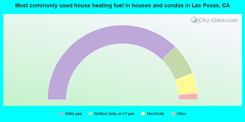
- 74.9%Utility gas
- 13.6%Bottled, tank, or LP gas
- 8.7%Electricity
- 2.0%Other fuel
- 0.8%Wood
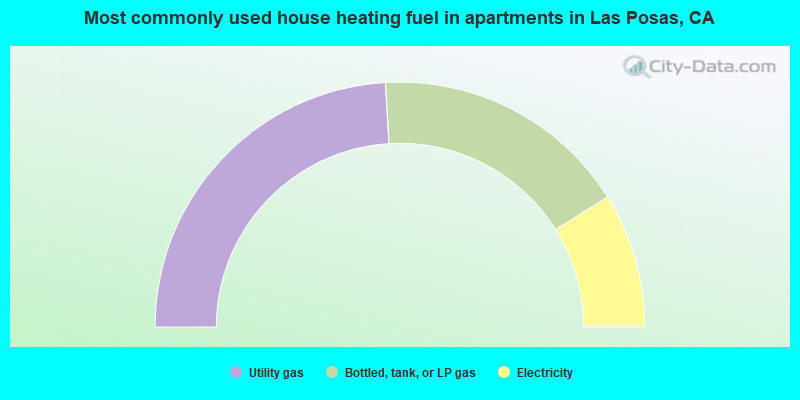
- 48.1%Utility gas
- 34.1%Bottled, tank, or LP gas
- 17.8%Electricity
Las Posas compared to California state average:
- Unemployed percentage significantly below state average.
- Median age below state average.
- Foreign-born population percentage significantly below state average.
- Length of stay since moving in significantly above state average.
- Number of rooms per house significantly below state average.
- House age significantly below state average.
- Institutionalized population percentage significantly above state average.
Las Posas on our top lists:
- #97 on the list of "Top 100 cities with highest median house value"
- #16 on the list of "Top 101 counties with the highest lead air pollution readings in 2012 (µg/m3)"
- #18 on the list of "Top 101 counties with the lowest lead air pollution readings in 2012 (µg/m3)"
- #38 on the list of "Top 101 counties with the highest Particulate Matter (PM10) Annual air pollution readings in 2012 (µg/m3)"
- #44 on the list of "Top 101 counties with the highest surface withdrawal of fresh water for public supply (pop. 50,000+)"
- #44 on the list of "Top 101 counties with the most Other congregations (pop. 50,000+)"