Harleton, Texas
Submit your own pictures of this place and show them to the world
- OSM Map
- General Map
- Google Map
- MSN Map

| Males: 3,186 | |
| Females: 3,159 |
| Median resident age: | 36.3 years |
| Texas median age: | 32.3 years |
Zip code: 75651
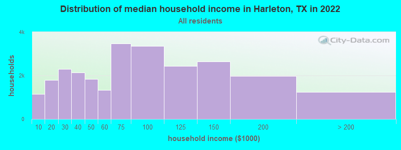
| Harleton: | $66,311 |
| TX: | $72,284 |
Estimated per capita income in 2022: $29,374 (it was $15,071 in 2000)
Harleton CCD income, earnings, and wages data
Estimated median house or condo value in 2022: $135,219 (it was $54,000 in 2000)
| Harleton: | $135,219 |
| TX: | $275,400 |
Detailed information about poverty and poor residents in Harleton, TX


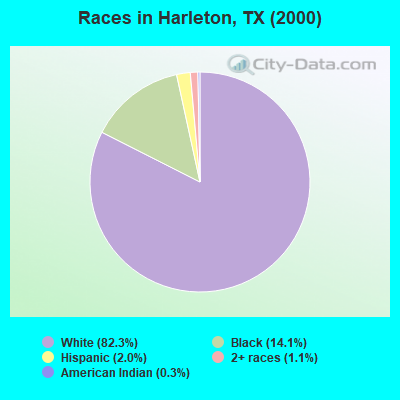
- 5,12082.3%White alone
- 87814.1%Black alone
- 1272.0%Hispanic
- 711.1%Two or more races
- 160.3%American Indian alone
- 50.08%Asian alone
- 20.03%Native Hawaiian and Other
Pacific Islander alone - 20.03%Other race alone
Races in Harleton detailed stats: ancestries, foreign born residents, place of birth
According to our research of Texas and other state lists, there were 16 registered sex offenders living in Harleton, Texas as of May 02, 2024.
The ratio of all residents to sex offenders in Harleton is 397 to 1.
The ratio of registered sex offenders to all residents in this city is near the state average.
 Recent articles from our blog. Our writers, many of them Ph.D. graduates or candidates, create easy-to-read articles on a wide variety of topics.
Current Local Time: CST time zone
Land area: 204.6 square miles.
Population density: 31 people per square mile (very low).

| Harleton CCD: | 1.0% ($548) |
| Texas: | 1.8% ($1,393) |
Nearest city with pop. 50,000+: Longview, TX  (17.7 miles , pop. 73,344).
Nearest city with pop. 200,000+: Shreveport, LA (45.7 miles , pop. 200,145).
Nearest city with pop. 1,000,000+: Dallas, TX (132.4 miles , pop. 1,188,580).
Nearest cities:
), ), ), ), Latitude: 32.67 N, Longitude: 94.52 W
Area code: 903

| Here: | 4.2% |
| Texas: | 3.5% |
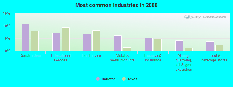
- Construction (10.7%)
- Educational services (7.1%)
- Health care (6.8%)
- Metal & metal products (6.2%)
- Finance & insurance (5.2%)
- Mining, quarrying, oil & gas extraction (4.2%)
- Food & beverage stores (3.7%)
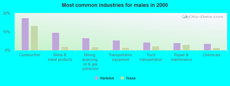
- Construction (17.6%)
- Metal & metal products (9.7%)
- Mining, quarrying, oil & gas extraction (6.6%)
- Transportation equipment (5.4%)
- Truck transportation (4.3%)
- Repair & maintenance (4.0%)
- Chemicals (3.5%)
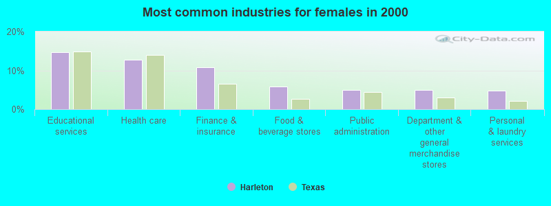
- Educational services (14.6%)
- Health care (12.7%)
- Finance & insurance (10.7%)
- Food & beverage stores (5.8%)
- Public administration (5.0%)
- Department & other general merchandise stores (4.9%)
- Personal & laundry services (4.8%)
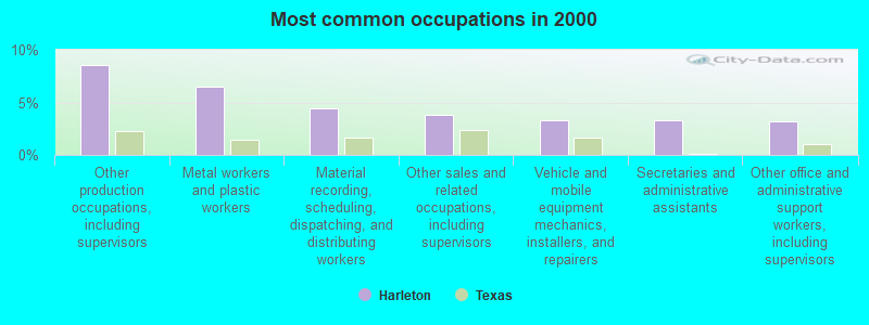
- Other production occupations, including supervisors (8.5%)
- Metal workers and plastic workers (6.5%)
- Material recording, scheduling, dispatching, and distributing workers (4.4%)
- Other sales and related occupations, including supervisors (3.8%)
- Vehicle and mobile equipment mechanics, installers, and repairers (3.3%)
- Secretaries and administrative assistants (3.3%)
- Other office and administrative support workers, including supervisors (3.2%)
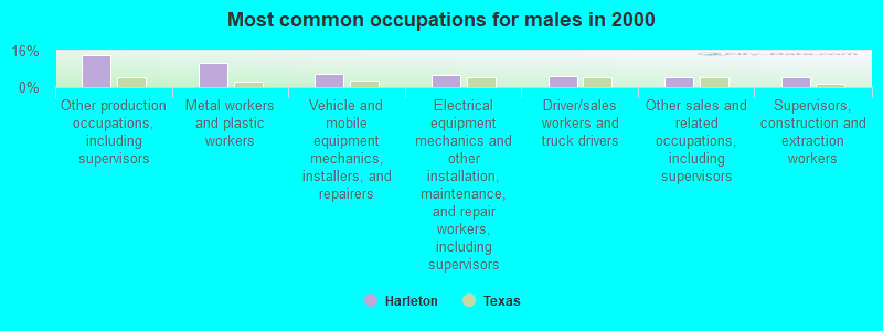
- Other production occupations, including supervisors (14.0%)
- Metal workers and plastic workers (10.7%)
- Vehicle and mobile equipment mechanics, installers, and repairers (5.7%)
- Electrical equipment mechanics and other installation, maintenance, and repair workers, including supervisors (5.4%)
- Driver/sales workers and truck drivers (5.0%)
- Other sales and related occupations, including supervisors (4.6%)
- Supervisors, construction and extraction workers (4.4%)
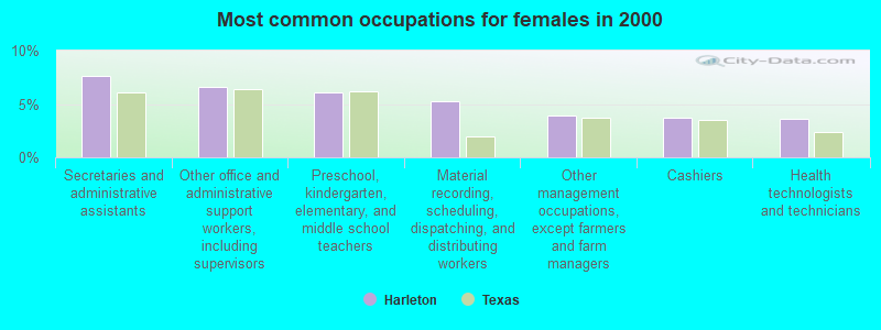
- Secretaries and administrative assistants (7.6%)
- Other office and administrative support workers, including supervisors (6.6%)
- Preschool, kindergarten, elementary, and middle school teachers (6.1%)
- Material recording, scheduling, dispatching, and distributing workers (5.2%)
- Other management occupations, except farmers and farm managers (3.9%)
- Cashiers (3.7%)
- Health technologists and technicians (3.6%)
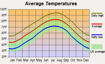
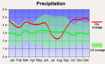
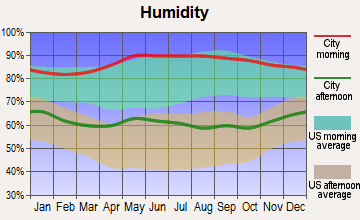
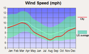
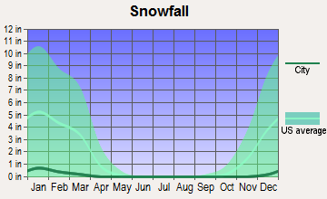
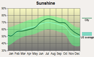
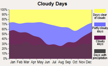
Average climate in Harleton, Texas
Based on data reported by over 4,000 weather stations
(lower is better)
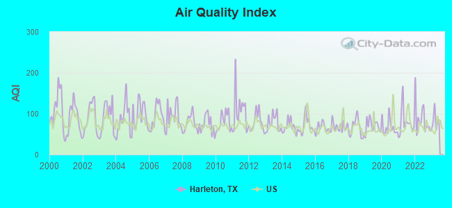
Air Quality Index (AQI) level in 2022 was 86.1. This is about average.
| City: | 86.1 |
| U.S.: | 72.6 |
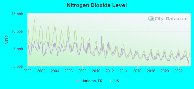
Nitrogen Dioxide (NO2) [ppb] level in 2022 was 2.70. This is significantly better than average. Closest monitor was 13.4 miles away from the city center.
| City: | 2.70 |
| U.S.: | 5.11 |
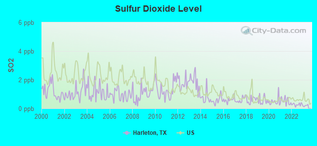
Sulfur Dioxide (SO2) [ppb] level in 2022 was 0.277. This is significantly better than average. Closest monitor was 23.1 miles away from the city center.
| City: | 0.277 |
| U.S.: | 1.515 |
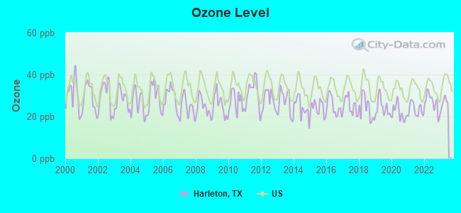
Ozone [ppb] level in 2022 was 26.6. This is better than average. Closest monitor was 13.4 miles away from the city center.
| City: | 26.6 |
| U.S.: | 33.3 |
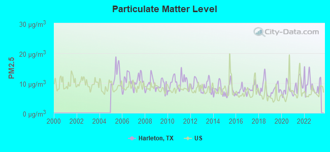
Particulate Matter (PM2.5) [µg/m3] level in 2022 was 9.88. This is worse than average. Closest monitor was 13.4 miles away from the city center.
| City: | 9.88 |
| U.S.: | 8.11 |
Tornado activity:
Harleton-area historical tornado activity is above Texas state average. It is 138% greater than the overall U.S. average.
On 4/1/1979, a category F3 (max. wind speeds 158-206 mph) tornado 13.6 miles away from the Harleton place center caused between $500,000 and $5,000,000 in damages.
On 9/22/1965, a category F3 tornado 14.4 miles away from the place center caused between $5000 and $50,000 in damages.
Earthquake activity:
Harleton-area historical earthquake activity is significantly above Texas state average. It is 394% greater than the overall U.S. average.On 11/6/2011 at 03:53:10, a magnitude 5.7 (5.7 MW, Depth: 3.2 mi, Class: Moderate, Intensity: VI - VII) earthquake occurred 236.2 miles away from Harleton center
On 5/17/2012 at 08:12:00, a magnitude 4.8 (4.8 MW, Depth: 3.1 mi, Class: Light, Intensity: IV - V) earthquake occurred 52.1 miles away from Harleton center
On 9/3/2016 at 12:02:44, a magnitude 5.8 (5.8 MW, Depth: 3.5 mi) earthquake occurred 293.9 miles away from Harleton center
On 9/2/2013 at 23:51:15, a magnitude 4.3 (4.3 MW, Depth: 2.9 mi) earthquake occurred 52.8 miles away from Harleton center
On 9/2/2013 at 21:52:38, a magnitude 4.2 (4.2 MW, Depth: 3.0 mi) earthquake occurred 48.7 miles away from Harleton center
On 1/25/2013 at 07:01:19, a magnitude 4.1 (4.1 MB, Depth: 3.1 mi) earthquake occurred 58.5 miles away from the city center
Magnitude types: body-wave magnitude (MB), moment magnitude (MW)
Natural disasters:
The number of natural disasters in Harrison County (20) is greater than the US average (15).Major Disasters (Presidential) Declared: 12
Emergencies Declared: 7
Causes of natural disasters: Floods: 8, Storms: 7, Hurricanes: 5, Fires: 4, Tornadoes: 4, Winds: 2, Winter Storms: 2, Other: 2 (Note: some incidents may be assigned to more than one category).
Hospitals and medical centers near Harleton:
- PINE HILL NURSING AND REHABILITATION (Nursing Home, about 12 miles away; JEFFERSON, TX)
- MARION COUNTY HOSPITAL (Hospital, about 12 miles away; JEFFERSON, TX)
- MAGNOLIA MANOR NURSING HOME (Nursing Home, about 12 miles away; JEFFERSON, TX)
- MARSHALL MANOR HOMECARE AND HOSPICE (Home Health Center, about 13 miles away; MARSHALL, TX)
- GROVE GARDENS CARE CENTER (Nursing Home, about 13 miles away; MARSHALL, TX)
- GOOD SHEPHERD HOMECARE - MARSHALL (Home Health Center, about 13 miles away; MARSHALL, TX)
- GOOD SHEPHERD MEDICAL CENTER MARSHALL Acute Care Hospitals (about 13 miles away; MARSHALL, TX)
Amtrak stations near Harleton:
- 12 miles: MARSHALL (FOOT OF N. WASHINGTON AVE.) . Services: ticket office, fully wheelchair accessible, enclosed waiting area, public restrooms, public payphones, vending machines, free short-term parking, free long-term parking, call for taxi service.
- 18 miles: LONGVIEW (905 PACIFIC AVE.) . Services: ticket office, fully wheelchair accessible, enclosed waiting area, public restrooms, public payphones, vending machines, free short-term parking, free long-term parking, call for taxi service.
Colleges/universities with over 2000 students nearest to Harleton:
- LeTourneau University (about 19 miles; Longview, TX; Full-time enrollment: 2,357)
- Kilgore College (about 29 miles; Kilgore, TX; FT enrollment: 3,127)
- Northeast Texas Community College (about 37 miles; Mount Pleasant, TX; FT enrollment: 2,320)
- Southern University at Shreveport (about 41 miles; Shreveport, LA; FT enrollment: 2,277)
- The University of Texas at Tyler (about 50 miles; Tyler, TX; FT enrollment: 5,774)
- Louisiana State University-Shreveport (about 51 miles; Shreveport, LA; FT enrollment: 3,159)
- Tyler Junior College (about 51 miles; Tyler, TX; FT enrollment: 8,104)
Public high school in Harleton:
- HARLETON H S (Students: 155, Location: 17000 STATE HWY 154, Grades: 9-12)
Public elementary/middle schools in Harleton:
- HARLETON EL (Students: 367, Location: 17240 STATE HWY 154, Grades: PK-5)
- HARLETON J H (Students: 215, Location: 17240 STATE HWY 154, Grades: 6-8)
Points of interest:
Notable locations in Harleton: Oak Haven Home (A), Nesbitt Volunteer Fire Department (B), Harleton Volunteer Fire Department (C). Display/hide their locations on the map
Churches in Harleton include: Potters Creek Church (A), Saint James Church (B), Saint Mark Church (C), Simmons Church (D), Smyrna Church (E), Springhill Church (F), Starlight Church (G), Sunnyhill Church (H), Woodlawn Church (I). Display/hide their locations on the map
Cemeteries: Nesbitt Cemetery (1), New Zion Cemetery (2), Center Cemetery (3), Davis Cemetery (4), Tage Cemetery (5), Eagle Creek Cemetery (6), Piney Cemetery (7). Display/hide their locations on the map
Lakes and reservoirs: Rock Lake (A), Bluff Spring Lake (B), Sanders Lake (C), Frances Lake (D), Franklin Lake (E), Lake Deerwood (F), Satterwhite Ranch Lake (G). Display/hide their locations on the map
Creeks: Rainey Creek (A), Pope Creek (B), Panther Creek (C), Page Creek (D), Moccasin Creek (E), Eagle Creek (F), Grays Creek (G), Gum Creek (H), Lawrence Creek (I). Display/hide their locations on the map
Birthplace of: George E. Johnson (basketball) - Basketball player.
| This place: | 2.7 people |
| Texas: | 2.8 people |
| This place: | 76.6% |
| Whole state: | 69.9% |
| This place: | 5.6% |
| Whole state: | 6.0% |
Likely homosexual households (counted as self-reported same-sex unmarried-partner households)
- Lesbian couples: 0.3% of all households
- Gay men: 0.1% of all households
| This place: | 14.6% |
| Whole state: | 15.4% |
| This place: | 6.5% |
| Whole state: | 6.7% |
Banks with branches in Harleton (2011 data):
- The First National Bank of Hughes Springs: Harleton Branch at 17045 State Hwy 154, branch established on 2006/01/01. Info updated 2012/02/07: Bank assets: $186.5 mil, Deposits: $153.7 mil, headquarters in Hughes Springs, TX, positive income, Commercial Lending Specialization, 11 total offices, Holding Company: Chalybeate Springs Corporation
For population 15 years and over in Harleton:
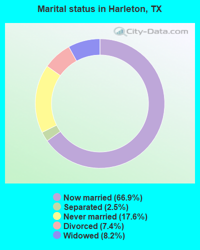
- Never married: 17.6%
- Now married: 66.9%
- Separated: 2.5%
- Widowed: 8.2%
- Divorced: 7.4%
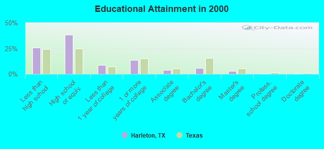
For population 25 years and over in Harleton:
- High school or higher: 74.4%
- Bachelor's degree or higher: 9.6%
- Graduate or professional degree: 3.6%
- Unemployed: 6.5%
- Mean travel time to work (commute): 28.7 minutes
| Here: | 10.7 |
| Texas average: | 15.6 |
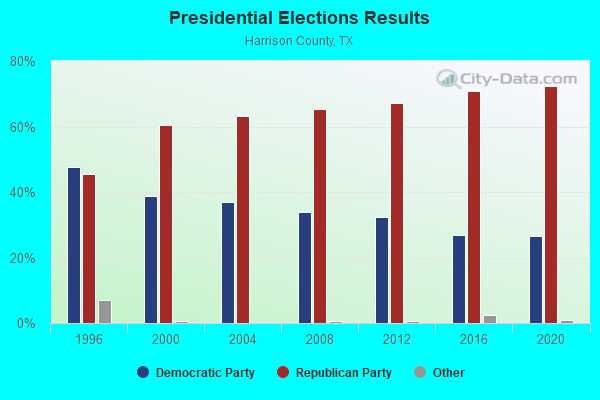
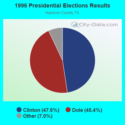
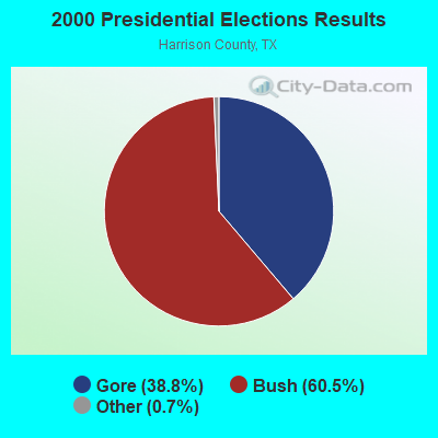
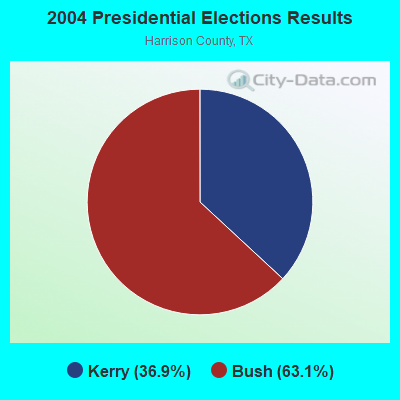
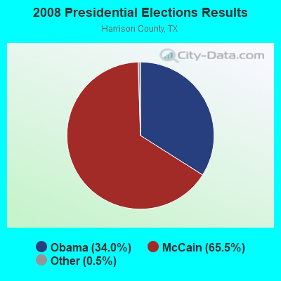


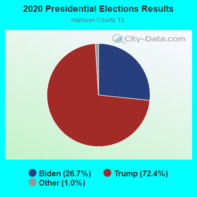
Graphs represent county-level data. Detailed 2008 Election Results
Religion statistics for Harleton, TX (based on Harrison County data)
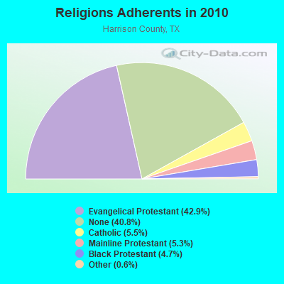
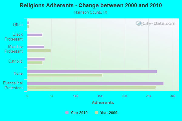
| Religion | Adherents | Congregations |
|---|---|---|
| Evangelical Protestant | 28,169 | 93 |
| Catholic | 3,641 | 3 |
| Mainline Protestant | 3,507 | 24 |
| Black Protestant | 3,117 | 16 |
| Other | 418 | 5 |
| None | 26,779 | - |
Food Environment Statistics:
| Harrison County: | 1.90 / 10,000 pop. |
| State: | 1.47 / 10,000 pop. |
| Harrison County: | 0.16 / 10,000 pop. |
| State: | 0.14 / 10,000 pop. |
| Harrison County: | 0.95 / 10,000 pop. |
| State: | 1.11 / 10,000 pop. |
| Harrison County: | 5.70 / 10,000 pop. |
| State: | 3.95 / 10,000 pop. |
| This county: | 4.59 / 10,000 pop. |
| State: | 6.13 / 10,000 pop. |
| This county: | 11.7% |
| State: | 8.9% |
| This county: | 28.9% |
| Texas: | 26.6% |
| This county: | 14.7% |
| State: | 15.7% |
Strongest AM radio stations in Harleton:
- KEEL (710 AM; 50 kW; SHREVEPORT, LA; Owner: CITICASTERS LICENSES, L.P.)
- KWKH (1130 AM; 50 kW; SHREVEPORT, LA; Owner: CITICASTERS LICENSES, L.P.)
- KPYN (900 AM; 10 kW; ATLANTA, TX; Owner: FAMILY WORSHIP CENTER CHURCH, INC.)
- KOFY (1060 AM; daytime; 10 kW; GILMER, TX; Owner: JERRY RUSSELL D/B/A THE RUSSELL COMPANY)
- KEES (1430 AM; 5 kW; GLADEWATER, TX; Owner: CITADEL BROADCASTING COMPANY)
- KFXR (1190 AM; 50 kW; DALLAS, TX; Owner: CLEAR CHANNEL BROADCASTING LICENSES, INC.)
- KTBB (600 AM; 5 kW; TYLER, TX; Owner: CITADEL BROADCASTING COMPANY)
- KNCB (1320 AM; 5 kW; VIVIAN, LA; Owner: NORTH CADDO BROADCASTING CO.)
- KMHT (1450 AM; 1 kW; MARSHALL, TX; Owner: HANSZEN BROADCAST GROUP, INC.)
- KRLD (1080 AM; 50 kW; DALLAS, TX; Owner: TEXAS INFINITY BROADCASTING L.P.)
- KFRO (1370 AM; 1 kW; LONGVIEW, TX; Owner: WALLER MEDIA, LLC)
- KOKA (980 AM; 5 kW; SHREVEPORT, LA; Owner: ACCESS.1 COMMUNICATIONS - SHREVEPORT, LLC)
- WBAP (820 AM; 50 kW; FORT WORTH, TX; Owner: WBAP-KSCS OPERATING, LTD.)
Strongest FM radio stations in Harleton:
- KYKX (105.7 FM; LONGVIEW, TX; Owner: WALLER MEDIA, LLC)
- KJTX (104.5 FM; JEFFERSON, TX; Owner: WISDOM MINISTRIES, INC.)
- KRMD-FM (101.1 FM; SHREVEPORT, LA; Owner: CUMULUS LICENSING CORP.)
- KMHT-FM (103.9 FM; MARSHALL, TX; Owner: HANSZEN BROADCAST GROUP, INC.)
- KCUL-FM (92.3 FM; MARSHALL, TX; Owner: ACCESS.1 COMMUNICATIONS CORP.-NY)
- KTAL-FM (98.1 FM; TEXARKANA, TX; Owner: ACCESS.1 COMMUNICATIONS - SHREVEPORT, LLC)
- KFRO-FM (95.3 FM; GILMER, TX; Owner: WALLER MEDIA, LLC)
- KRUF (94.5 FM; SHREVEPORT, LA; Owner: CITICASTERS LICENSES, L.P.)
- KXKS-FM (93.7 FM; SHREVEPORT, LA; Owner: CITICASTERS LICENSES, L.P.)
- KIXK (99.3 FM; WHITE OAK, TX; Owner: REYNOLDS RADIO, INC.)
- KNUE (101.5 FM; TYLER, TX; Owner: CAPSTAR TX LIMITED PARTNERSHIP)
- KDAQ (89.9 FM; SHREVEPORT, LA; Owner: BD. SUP. LA ST. UNIV. & AGRIC. MECH.)
- KTAA (90.7 FM; BIG SANDY, TX; Owner: INSTITUTE IN BASIC LIFE PRINCIPLES, INC.)
- KVMA-FM (107.9 FM; MAGNOLIA, AR; Owner: COLUMBIA BROADCASTING CO., INC.)
- KTUX (98.9 FM; CARTHAGE, TX; Owner: CITICASTERS LICENSES, L.P.)
- KVNE (89.5 FM; TYLER, TX; Owner: EDUC. RADIO FOUND. OF E. TEXAS, INC.)
- KVKI-FM (96.5 FM; SHREVEPORT, LA; Owner: CITICASTERS LICENSES, L.P.)
- KKTX-FM (96.1 FM; KILGORE, TX; Owner: CAPSTAR TX LIMITED PARTNERSHIP)
- KAZE (106.9 FM; ORE CITY, TX; Owner: REYNOLDS RADIO, INC.)
- KBWC (91.1 FM; MARSHALL, TX; Owner: WILEY COLLEGE)
TV broadcast stations around Harleton:
- KTBS-TV (Channel 3; SHREVEPORT, LA; Owner: KTBS, INC.)
- KSLA-TV (Channel 12; SHREVEPORT, LA; Owner: KSLA, LLC)
- KMSS-TV (Channel 33; SHREVEPORT, LA; Owner: COMCORP OF TEXAS LICENSE CORP.)
- KTAL-TV (Channel 6; TEXARKANA, TX; Owner: NEXSTAR BROADCASTING OF LOUISIANA, LLC)
- KSHV (Channel 45; SHREVEPORT, LA; Owner: WHITE KNIGHT BROADCASTING OF SHREVEPORT LIC. CORP.)
- KLTV (Channel 7; TYLER, TX; Owner: CIVCO, INC.)
- KLTS-TV (Channel 24; SHREVEPORT, LA; Owner: LOUISIANA EDUCATIONAL TELEVISION AUTHORITY)
- KLPN-LP (Channel 58; LONGVIEW, TX; Owner: WARWICK COMMUNICATIONS, INC.)
- KFXK (Channel 51; LONGVIEW, TX; Owner: WARWICK COMMUNICATIONS, INC.)
- K59GO (Channel 59; SHREVEPORT, LA; Owner: TRINITY BROADCASTING NETWORK, INC.)
- KLGV-LP (Channel 10; LONGVIEW, TX; Owner: INTERNATIONAL BROADCASTING NETWORK)
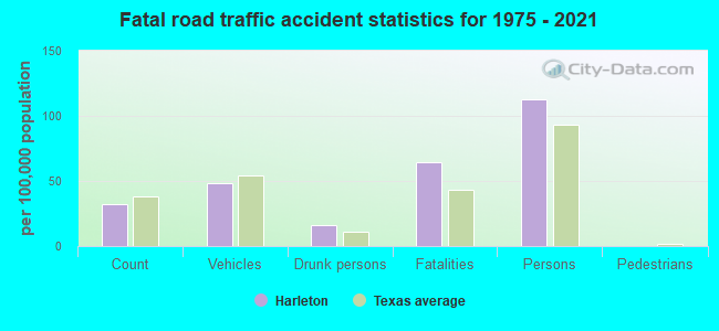
Harleton fatal accident list:
Aug 2, 1980 09:45 PM, Vehicles: 2, Persons: 5, Fatalities: 2, Drunk persons involved: 1
FCC Registered Cell Phone Towers:
1 (See the full list of FCC Registered Cell Phone Towers in Harleton)FCC Registered Antenna Towers:
33 (See the full list of FCC Registered Antenna Towers)FCC Registered Microwave Towers:
5- STATION, .5 Mi W Of Harleton On Hwy 154 (Lat: 32.678194 Lon: -94.587694), Overall height: 57.9 m, Call Sign: WNTS616,
Assigned Frequencies: 928.543 MHz, 952.543 MHz, Grant Date: 08/24/1993, Expiration Date: 08/24/1998, Phone: (214) 426-7980
- STATION, Lat: 32.695972 Lon: -94.500194, Overall height: 6.1 m, Call Sign: WNTU687,
Assigned Frequencies: 956.293 MHz, Grant Date: 03/05/2019, Expiration Date: 03/21/2029, Certifier: David B Trego, Registrant: American Electric Power Service Corporation, 850 Tech Center Drive, Gahanna, OH 43230, Phone: (614) 883-7265, Fax: (614) 883-6917, Email:
- ASHLAND, 0.9 Mi N Of Sr 154 & Dunn Cuttoff Rd (Ashland Site) (Lat: 32.690333 Lon: -94.620806), Type: Tower, Structure height: 91.4 m, Overall height: 98.4 m, Call Sign: WQOH398,
Assigned Frequencies: 6286.19 MHz, Grant Date: 09/27/2011, Expiration Date: 09/27/2021, Cancellation Date: 03/26/2013, Certifier: Pamelia Y Hoof, Registrant: Verizon Wireless, 1120 Sanctuary Pkwy, #150 Gasa5reg, Alpharetta, GA 30009-7630, Phone: (770) 797-1070, Fax: (770) 797-1036, Email:
- HARLETON, 16325 Farm Road 2208 (Lat: 32.667000 Lon: -94.560639), Type: Gtower, Structure height: 102.7 m, Overall height: 107.3 m, Call Sign: WQQR203,
Assigned Frequencies: 11385.0 MHz, 11505.0 MHz, 11385.0 MHz, 11505.0 MHz, 11385.0 MHz, 11505.0 MHz, 11385.0 MHz, 11505.0 MHz, 11385.0 MHz, 11505.0 MHz... (+14 more), Grant Date: 02/14/2013, Expiration Date: 02/14/2023, Cancellation Date: 12/27/2022, Certifier: Christopher Pickard, Registrant: Uniti Fiber LLC, 107 St. Francis Street, Suite 1800, Mobile, AL 36602, Phone: (877) 652-2321, Email:
- HARLETON, 16325 Farm Road 2208 (Lat: 32.667000 Lon: -94.560639), Type: Gtower, Structure height: 102.7 m, Overall height: 107.3 m, Call Sign: WQRQ749,
Assigned Frequencies: 6197.24 MHz, 6256.54 MHz, 6226.89 MHz, 6256.54 MHz, Grant Date: 06/06/2023, Expiration Date: 07/10/2033, Certifier: John E Monday, Registrant: Att&t Services, Inc., 208 S Akard St, 20f, Dallas, TX 75202, Phone: (855) 699-7073, Email:
FCC Registered Amateur Radio Licenses:
19 (See the full list of FCC Registered Amateur Radio Licenses in Harleton)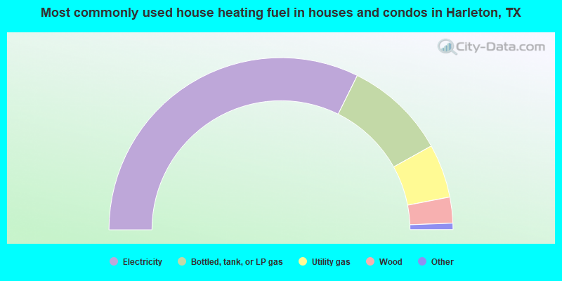
- 64.7%Electricity
- 19.2%Bottled, tank, or LP gas
- 10.1%Utility gas
- 4.9%Wood
- 1.1%Other fuel
- 0.1%No fuel used
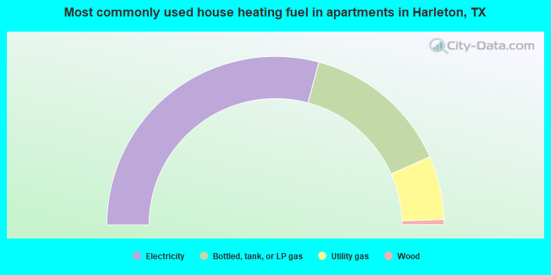
- 58.3%Electricity
- 28.5%Bottled, tank, or LP gas
- 12.2%Utility gas
- 1.0%Wood
Harleton compared to Texas state average:
- Median house value below state average.
- Unemployed percentage below state average.
- Hispanic race population percentage significantly below state average.
- Median age above state average.
- Foreign-born population percentage significantly below state average.
- Renting percentage significantly below state average.
- Length of stay since moving in significantly above state average.
- Number of rooms per house significantly below state average.
- House age significantly below state average.
- Number of college students below state average.
- Percentage of population with a bachelor's degree or higher significantly below state average.
Harleton on our top lists:
- #4 on the list of "Top 101 cities with largest percentage of males in occupations: other production occupations including supervisors (population 5,000+)"
- #7 on the list of "Top 101 cities with largest percentage of males in industries: sporting goods, camera, and hobby and toy stores (population 5,000+)"
- #10 on the list of "Top 101 cities with largest percentage of males in occupations: metal workers and plastic workers (population 5,000+)"
- #10 on the list of "Top 101 cities with largest percentage of females in occupations: supervisors of transportation and material moving workers (population 5,000+)"
- #15 on the list of "Top 101 cities with largest percentage of females in occupations: material moving workers except supervisors and laborers and material movers, hand (population 5,000+)"
- #17 on the list of "Top 101 cities with largest percentage of males in occupations: extraction workers (population 5,000+)"
- #17 on the list of "Top 101 cities with largest percentage of females in occupations: motor vehicle operators except bus and truck drivers (population 5,000+)"
- #19 on the list of "Top 101 cities with largest percentage of females in industries: personal and laundry services (population 5,000+)"
- #23 on the list of "Top 101 cities with largest percentage of males in industries: metal and metal products (population 5,000+)"
- #40 on the list of "Top 101 cities with largest percentage of males in industries: furniture and home furnishings, and household appliance stores (population 5,000+)"
- #46 on the list of "Top 101 cities with largest percentage of females in industries: motor vehicle and parts dealers (population 5,000+)"
- #71 on the list of "Top 101 cities with largest percentage of females in industries: food and beverage stores (population 5,000+)"
- #79 on the list of "Top 101 cities with largest percentage of females in industries: warehousing and storage (population 5,000+)"
- #84 on the list of "Top 101 cities with largest percentage of males in industries: chemicals (population 5,000+)"
- #85 on the list of "Top 101 cities with largest percentage of males in industries: electrical equipment, appliances, and components (population 5,000+)"
- #89 on the list of "Top 101 cities with largest percentage of males in industries: farm product raw materials merchant wholesalers (population 5,000+)"
- #91 on the list of "Top 101 cities with largest percentage of females in industries: petroleum and petroleum products merchant wholesalers (population 5,000+)"
- #92 on the list of "Top 101 cities with largest percentage of males in industries: furniture and related product manufacturing (population 5,000+)"
- #17 on the list of "Top 101 counties with the lowest Nitrogen Dioxide air pollution readings in 2012 (ppm)"

|
Total of 2 patent applications in 2008-2024.