Fremont, New Hampshire
Submit your own pictures of this town and show them to the world
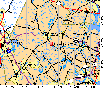
- OSM Map
- General Map
- Google Map
- MSN Map
Population change since 2000: +22.0%
| Males: 2,122 | |
| Females: 2,161 |
| Median resident age: | 40.5 years |
| New Hampshire median age: | 43.9 years |
Zip codes: 03044.
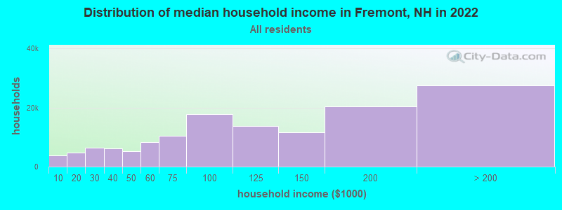
| Fremont: | $114,871 |
| NH: | $89,992 |
Estimated per capita income in 2022: $52,863 (it was $24,082 in 2000)
Fremont town income, earnings, and wages data
Estimated median house or condo value in 2022: $476,061 (it was $155,800 in 2000)
| Fremont: | $476,061 |
| NH: | $384,700 |
Mean prices in 2022: all housing units: $614,227; detached houses: $665,470; townhouses or other attached units: $408,866; in 2-unit structures: $730,084; in 3-to-4-unit structures: over $1,000,000; in 5-or-more-unit structures: $329,099; mobile homes: $126,160
Detailed information about poverty and poor residents in Fremont, NH
Compare current foreclosures near Fremont, NH:
| Photo | Address | Area | Beds / Baths | Price | Details |
|---|---|---|---|---|---|

|
#1
Louise Ln
Fremont, NH 03044
|
1,960 sq. feet
|
2 baths 3 beds |
show details | |

|
#2
Cedar St # A
Haverhill, MA 01830
|
1,134 sq. feet
|
2 baths 2 beds |
$209,300
|
show details |

|
#3
Shore Dr
Hampstead, NH 03841
|
787 sq. feet
|
1 baths 2 beds |
$529,900
|
show details |

|
#4
Brentwood Rd
Exeter, NH 03833
|
2,756 sq. feet
|
2 baths 3 beds |
$419,900
|
show details |

|
#5
Lawrence Rd
Salem, NH 03079
|
1,305 sq. feet
|
1 baths 1 beds |
show details | |

|
#6
Michael Ave
Derry, NH 03038
|
1,536 sq. feet
|
1 baths 4 beds |
show details | |

|
#7
Brook St
Derry, NH 03038
|
1,476 sq. feet
|
2 baths 4 beds |
show details | |

|
#8
Redfield Cir
Derry, NH 03038
|
2,124 sq. feet
|
3 baths 4 beds |
show details | |

|
#9
High St
Derry, NH 03038
|
2,149 sq. feet
|
3 baths 4 beds |
show details | |

|
#10
High St
Exeter, NH 03833
|
3,075 sq. feet
|
3 baths 4 beds |
show details |
| Photo | Address | Area | Beds / Baths | Price | Details |
|---|---|---|---|---|---|

|
#11
Donati Dr
Hooksett, NH 03106
|
2,269 sq. feet
|
3 baths 5 beds |
show details | |

|
#12
Pine Ridge Rd
Windham, NH 03087
|
1,746 sq. feet
|
2 baths 4 beds |
show details | |

|
#13
Smoke St
Nottingham, NH 03290
|
2,396 sq. feet
|
3 baths 3 beds |
show details | |

|
#14
Old Turnpike Rd
Nottingham, NH 03290
|
4,738 sq. feet
|
3 baths 3 beds |
show details | |

|
#15
Maclarnon Rd
Salem, NH 03079
|
1,578 sq. feet
|
2 baths 3 beds |
show details | |

|
#16
Jasper St
Methuen, MA 01844
|
1,382 sq. feet
|
1 baths 2 beds |
show details | |

|
#17
Merrill Ave
Haverhill, MA 01830
|
2,416 sq. feet
|
2 baths 4 beds |
show details | |

|
#18
Muse Ter
Salem, NH 03079
|
1,024 sq. feet
|
1 baths 3 beds |
show details | |

|
#19
Lawrence St
Derry, NH 03038
|
2,124 sq. feet
|
2 baths 3 beds |
show details | |

|
#20
Maple St
Amesbury, MA 01913
|
2,186 sq. feet
|
2 baths 4 beds |
show details |
| Photo | Address | Area | Beds / Baths | Price | Details |
|---|---|---|---|---|---|

|
#21
Brook St
Derry, NH 03038
|
1,666 sq. feet
|
1 baths 4 beds |
show details | |

|
#22
Brook St
Derry, NH 03038
|
1,476 sq. feet
|
1 baths 4 beds |
show details | |

|
#23
Storey Ave Apt 2
Newburyport, MA 01950
|
708 sq. feet
|
1 baths 2 beds |
show details | |

|
#24
Lake St
Amesbury, MA 01913
|
2,650 sq. feet
|
2 baths 4 beds |
show details | |

|
#25
Hazen Ave
Haverhill, MA 01830
|
2,594 sq. feet
|
2 baths 7 beds |
show details | |

|
#26
Mechanic St Apt 1
Merrimac, MA 01860
|
1,452 sq. feet
|
1 baths 2 beds |
show details | |

|
#27
Everett St
Derry, NH 03038
|
1,596 sq. feet
|
1 baths 3 beds |
show details | |

|
#28
Baldwin St
Haverhill, MA 01832
|
2,504 sq. feet
|
2 baths 6 beds |
show details | |

|
#29
Gayle Dr
Derry, NH 03038
|
1,246 sq. feet
|
1 baths 3 beds |
show details | |

|
#30
Gove Dr
Newburyport, MA 01950
|
3,044 sq. feet
|
3 baths 3 beds |
show details |
| Photo | Address | Area | Beds / Baths | Price | Details |
|---|---|---|---|---|---|

|
#31
Elm St
Salisbury, MA 01952
|
1,800 sq. feet
|
2 baths 4 beds |
show details | |

|
#32
Wells St
Manchester, NH 03104
|
2,800 sq. feet
|
1 baths 3 beds |
show details | |

|
#33
Whittier Meadows Dr
Amesbury, MA 01913
|
1,344 sq. feet
|
2 baths 2 beds |
show details | |

|
#34
Peyton Way
Haverhill, MA 01832
|
2,724 sq. feet
|
2 baths 4 beds |
show details | |

|
#35
Fairview Ave
Derry, NH 03038
|
1,510 sq. feet
|
1 baths 3 beds |
show details | |

|
#36
Bard St
Haverhill, MA 01835
|
1,666 sq. feet
|
1 baths 3 beds |
show details | |

|
#37
Kimball Rd
Amesbury, MA 01913
|
1,792 sq. feet
|
1 baths 3 beds |
show details | |

|
#38
Brown Ave # 52
Amesbury, MA 01913
|
741 sq. feet
|
1 baths 2 beds |
show details | |

|
#39
Juniper Wood Dr
Haverhill, MA 01832
|
2,404 sq. feet
|
2 baths 4 beds |
show details | |

|
#40
Old Ferry Rd
Haverhill, MA 01830
|
2,099 sq. feet
|
2 baths 4 beds |
show details |
| Photo | Address | Area | Beds / Baths | Price | Details |
|---|---|---|---|---|---|

|
#41
Upland Ave
Haverhill, MA 01835
|
1,753 sq. feet
|
2 baths 3 beds |
show details | |

|
#42
Acorn S 2
Haverhill, MA 01832
|
896 sq. feet
|
1 baths 2 beds |
show details | |

|
#43
Maxwell St
Haverhill, MA 01832
|
1,036 sq. feet
|
1 baths 2 beds |
show details | |

|
#44
Main St Apt 4
Amesbury, MA 01913
|
645 sq. feet
|
1 baths 1 beds |
show details | |

|
#45
Cedar St
Haverhill, MA 01830
|
2,162 sq. feet
|
2 baths 3 beds |
show details | |

|
#46
Del Logan Dr
Salisbury, MA 01952
|
1,986 sq. feet
|
1 baths 3 beds |
show details | |

|
#47
Kenoza Ave Apt 1
Haverhill, MA 01830
|
750 sq. feet
|
1 baths 2 beds |
show details | |

|
#48
Webster St
Haverhill, MA 01830
|
1,887 sq. feet
|
2 baths 3 beds |
show details | |

|
#49
Alexander Ave
Salem, NH 03079
|
1,149 sq. feet
|
1 baths 3 beds |
show details | |

|
Check over 1 million property listings on Foreclosure.com!
|
browse all offers | |||

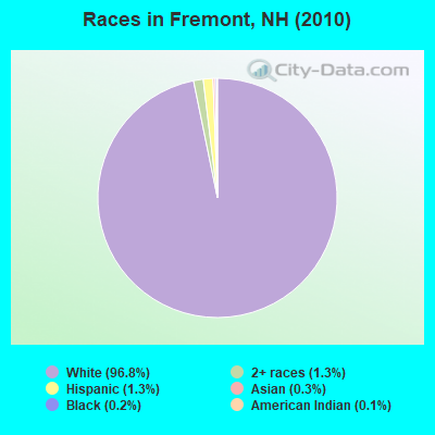
- 4,14796.8%White alone
- 551.3%Two or more races
- 541.3%Hispanic
- 110.3%Asian alone
- 70.2%Black alone
- 50.1%American Indian alone
- 40.09%Other race alone
Races in Fremont detailed stats: ancestries, foreign born residents, place of birth
According to our research of New Hampshire and other state lists, there was 1 registered sex offender living in Fremont, New Hampshire as of May 17, 2024.
The ratio of all residents to sex offenders in Fremont is 4,283 to 1.
The ratio of registered sex offenders to all residents in this city is much lower than the state average.
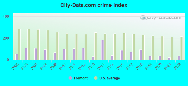
Type |
2009 |
2010 |
2011 |
2012 |
2013 |
2014 |
2015 |
2016 |
2017 |
2018 |
2019 |
2020 |
2021 |
2022 |
|---|---|---|---|---|---|---|---|---|---|---|---|---|---|---|
| Murders (per 100,000) | 0 (0.0) | 0 (0.0) | 0 (0.0) | 0 (0.0) | 0 (0.0) | 2 (44.8) | 0 (0.0) | 0 (0.0) | 0 (0.0) | 0 (0.0) | 0 (0.0) | 0 (0.0) | 0 (0.0) | 0 (0.0) |
| Rapes (per 100,000) | 0 (0.0) | 1 (23.3) | 2 (46.6) | 1 (23.2) | 0 (0.0) | 2 (44.8) | 0 (0.0) | 2 (43.0) | 2 (42.2) | 3 (62.2) | 0 (0.0) | 1 (21.0) | 0 (0.0) | 1 (20.8) |
| Robberies (per 100,000) | 0 (0.0) | 0 (0.0) | 0 (0.0) | 0 (0.0) | 0 (0.0) | 0 (0.0) | 0 (0.0) | 0 (0.0) | 1 (21.1) | 0 (0.0) | 0 (0.0) | 0 (0.0) | 0 (0.0) | 0 (0.0) |
| Assaults (per 100,000) | 3 (71.4) | 2 (46.7) | 3 (69.9) | 5 (116.1) | 1 (22.9) | 3 (67.2) | 1 (21.9) | 4 (86.1) | 2 (42.2) | 3 (62.2) | 0 (0.0) | 1 (21.0) | 2 (41.3) | 2 (41.7) |
| Burglaries (per 100,000) | 4 (95.1) | 19 (443.6) | 11 (256.5) | 15 (348.4) | 8 (183.4) | 9 (201.6) | 8 (175.1) | 9 (193.6) | 2 (42.2) | 9 (186.7) | 3 (62.5) | 1 (21.0) | 0 (0.0) | 1 (20.8) |
| Thefts (per 100,000) | 39 (927.7) | 35 (817.2) | 25 (582.9) | 45 (1,045) | 9 (206.3) | 32 (716.8) | 19 (415.8) | 28 (602.4) | 23 (485.5) | 24 (497.8) | 32 (666.3) | 16 (335.9) | 15 (309.5) | 11 (229.3) |
| Auto thefts (per 100,000) | 4 (95.1) | 3 (70.0) | 6 (139.9) | 0 (0.0) | 1 (22.9) | 1 (22.4) | 4 (87.5) | 0 (0.0) | 1 (21.1) | 0 (0.0) | 2 (41.6) | 1 (21.0) | 1 (20.6) | 1 (20.8) |
| Arson (per 100,000) | 3 (71.4) | 1 (23.3) | 1 (23.3) | 0 (0.0) | 0 (0.0) | 1 (22.4) | 0 (0.0) | 2 (43.0) | 1 (21.1) | 0 (0.0) | 1 (20.8) | 0 (0.0) | 0 (0.0) | 1 (20.8) |
| City-Data.com crime index | 65.7 | 97.4 | 103.8 | 108.0 | 27.5 | 183.5 | 40.3 | 89.3 | 72.6 | 95.2 | 34.4 | 37.6 | 22.3 | 37.3 |
The City-Data.com crime index weighs serious crimes and violent crimes more heavily. Higher means more crime, U.S. average is 246.1. It adjusts for the number of visitors and daily workers commuting into cities.
Crime rate in Fremont detailed stats: murders, rapes, robberies, assaults, burglaries, thefts, arson
Full-time law enforcement employees in 2021, including police officers: 7 (6 officers - 5 male; 1 female).
| Officers per 1,000 residents here: | 1.24 |
| New Hampshire average: | 2.14 |
 Recent articles from our blog. Our writers, many of them Ph.D. graduates or candidates, create easy-to-read articles on a wide variety of topics.

 | seeking driver with trailer for nh to pa haul (2 replies) |
| Thoughts on the Free State Project (82 replies) |
| any info about Fremont development (0 replies) |
| What do you know about Fremont (1 reply) |
| Relocation to new hampshire (28 replies) |
| Assessing Fremont's priorities (2 replies) |
Latest news from Fremont, NH collected exclusively by city-data.com from local newspapers, TV, and radio stations
Ancestries: Irish (27.3%), French (23.4%), English (13.4%), French Canadian (12.2%), Italian (8.4%), German (6.7%).
Current Local Time: EST time zone
Incorporated in 1764
Elevation: 158 feet
Land area: 17.2 square miles.
Population density: 250 people per square mile (very low).
67 residents are foreign born
| This town: | 1.9% |
| New Hampshire: | 4.4% |
| Fremont town: | 1.8% ($2,792) |
| New Hampshire: | 2.3% ($2,946) |
Nearest city with pop. 50,000+: Haverhill, MA  (14.3 miles , pop. 58,969).
Nearest city with pop. 200,000+: Boston, MA (45.8 miles , pop. 589,141).
Nearest city with pop. 1,000,000+: Bronx, NY (204.6 miles , pop. 1,332,650).
Nearest cities:
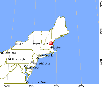
), ), ), )Latitude: 42.98 N, Longitude: 71.12 W
Area code commonly used in this area: 603

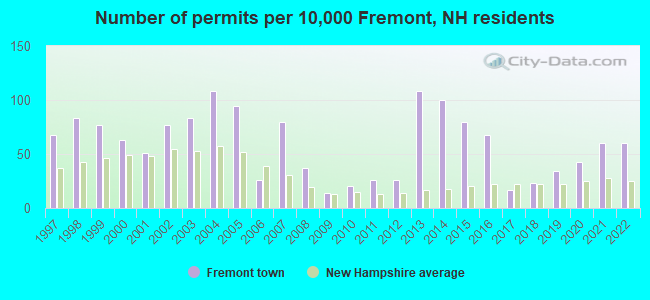
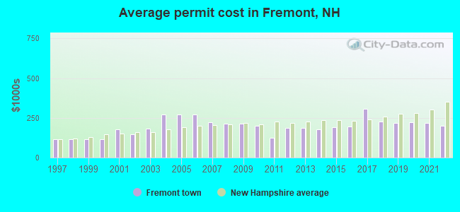
Single-family new house construction building permits:
- 2022: 21 buildings, average cost: $200,400
- 2021: 21 buildings, average cost: $216,900
- 2020: 15 buildings, average cost: $223,200
- 2019: 12 buildings, average cost: $215,900
- 2018: 8 buildings, average cost: $228,800
- 2017: 6 buildings, average cost: $309,100
- 2016: 24 buildings, average cost: $197,400
- 2015: 28 buildings, average cost: $189,600
- 2014: 35 buildings, average cost: $177,800
- 2013: 38 buildings, average cost: $187,000
- 2012: 9 buildings, average cost: $187,000
- 2011: 9 buildings, average cost: $125,000
- 2010: 7 buildings, average cost: $200,000
- 2009: 5 buildings, average cost: $212,000
- 2008: 13 buildings, average cost: $212,300
- 2007: 28 buildings, average cost: $220,500
- 2006: 9 buildings, average cost: $270,000
- 2005: 33 buildings, average cost: $270,000
- 2004: 38 buildings, average cost: $270,000
- 2003: 29 buildings, average cost: $180,500
- 2002: 27 buildings, average cost: $147,500
- 2001: 18 buildings, average cost: $178,000
- 2000: 22 buildings, average cost: $116,100
- 1999: 27 buildings, average cost: $116,200
- 1998: 29 buildings, average cost: $116,100
- 1997: 24 buildings, average cost: $116,400
| Here: | 2.6% |
| New Hampshire: | 2.5% |
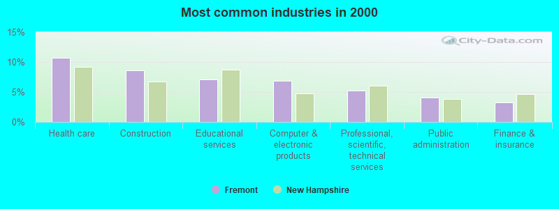
- Health care (10.7%)
- Construction (8.6%)
- Educational services (7.1%)
- Computer & electronic products (6.8%)
- Professional, scientific, technical services (5.2%)
- Public administration (4.1%)
- Finance & insurance (3.3%)
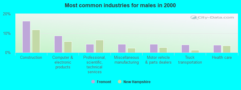
- Construction (16.3%)
- Computer & electronic products (8.7%)
- Professional, scientific, technical services (4.3%)
- Miscellaneous manufacturing (4.3%)
- Motor vehicle & parts dealers (4.3%)
- Truck transportation (4.1%)
- Health care (3.9%)
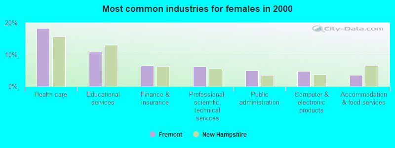
- Health care (18.3%)
- Educational services (10.9%)
- Finance & insurance (6.5%)
- Professional, scientific, technical services (6.1%)
- Public administration (5.0%)
- Computer & electronic products (4.8%)
- Accommodation & food services (3.6%)
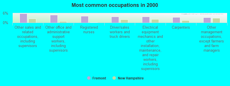
- Other sales and related occupations, including supervisors (5.8%)
- Other office and administrative support workers, including supervisors (4.9%)
- Registered nurses (4.3%)
- Driver/sales workers and truck drivers (3.9%)
- Electrical equipment mechanics and other installation, maintenance, and repair workers, including supervisors (3.8%)
- Carpenters (3.4%)
- Other management occupations, except farmers and farm managers (3.3%)
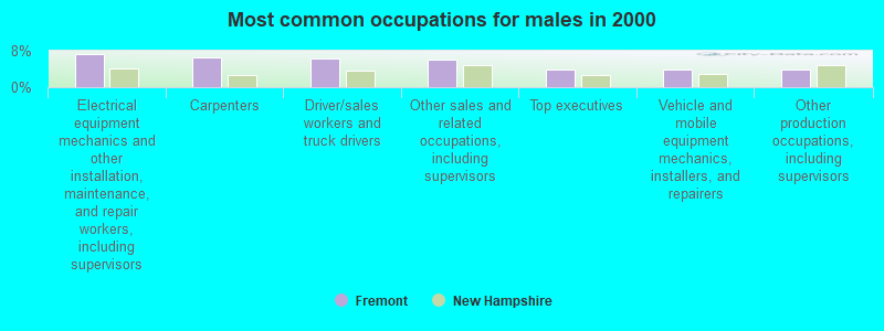
- Electrical equipment mechanics and other installation, maintenance, and repair workers, including supervisors (7.2%)
- Carpenters (6.5%)
- Driver/sales workers and truck drivers (6.3%)
- Other sales and related occupations, including supervisors (5.9%)
- Top executives (4.0%)
- Vehicle and mobile equipment mechanics, installers, and repairers (3.9%)
- Other production occupations, including supervisors (3.8%)

- Other office and administrative support workers, including supervisors (8.5%)
- Registered nurses (7.7%)
- Other sales and related occupations, including supervisors (5.6%)
- Secretaries and administrative assistants (5.5%)
- Retail sales workers, except cashiers (5.1%)
- Other teachers, instructors, education, training, and library occupations (3.9%)
- Health technologists and technicians (3.5%)
Average climate in Fremont, New Hampshire
Based on data reported by over 4,000 weather stations


(lower is better)
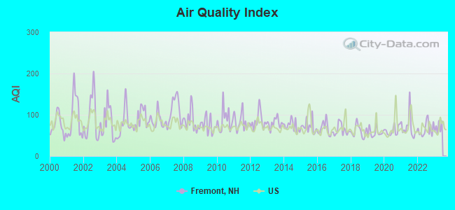
Air Quality Index (AQI) level in 2022 was 65.2. This is about average.
| City: | 65.2 |
| U.S.: | 72.6 |
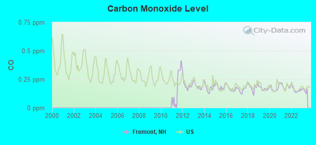
Carbon Monoxide (CO) [ppm] level in 2022 was 0.157. This is significantly better than average. Closest monitor was 15.4 miles away from the city center.
| City: | 0.157 |
| U.S.: | 0.251 |
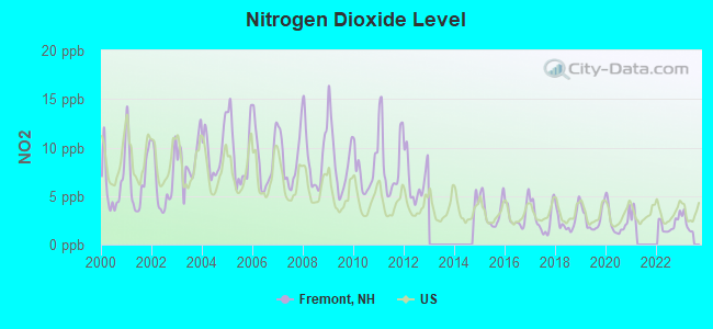
Nitrogen Dioxide (NO2) [ppb] level in 2022 was 2.05. This is significantly better than average. Closest monitor was 4.0 miles away from the city center.
| City: | 2.05 |
| U.S.: | 5.11 |
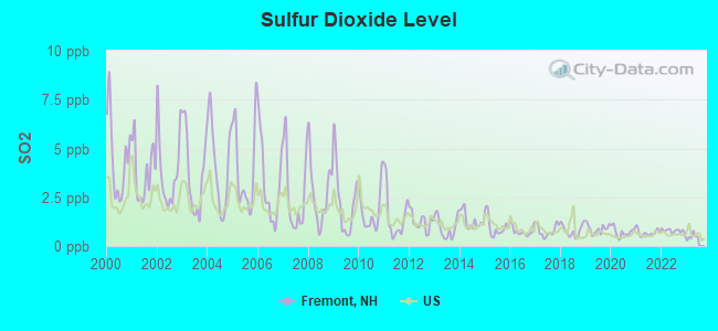
Sulfur Dioxide (SO2) [ppb] level in 2022 was 0.775. This is significantly better than average. Closest monitor was 14.4 miles away from the city center.
| City: | 0.775 |
| U.S.: | 1.515 |
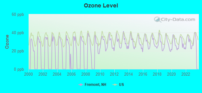
Ozone [ppb] level in 2022 was 29.8. This is about average. Closest monitor was 11.6 miles away from the city center.
| City: | 29.8 |
| U.S.: | 33.3 |
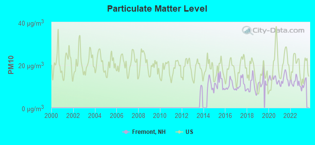
Particulate Matter (PM10) [µg/m3] level in 2022 was 12.0. This is significantly better than average. Closest monitor was 15.4 miles away from the city center.
| City: | 12.0 |
| U.S.: | 19.2 |
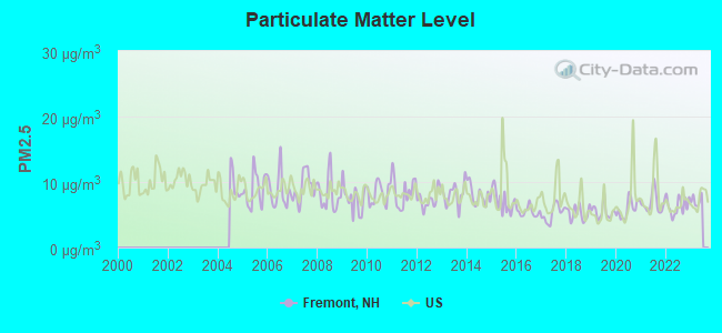
Particulate Matter (PM2.5) [µg/m3] level in 2022 was 6.34. This is better than average. Closest monitor was 14.7 miles away from the city center.
| City: | 6.34 |
| U.S.: | 8.11 |
Tornado activity:
Fremont-area historical tornado activity is slightly above New Hampshire state average. It is 46% smaller than the overall U.S. average.
On 6/9/1953, a category F3 (max. wind speeds 158-206 mph) tornado 7.9 miles away from the Fremont town center injured 5 people and caused between $5000 and $50,000 in damages.
On 9/29/1974, a category F3 tornado 25.4 miles away from the town center injured one person and caused between $50,000 and $500,000 in damages.
Earthquake activity:
Fremont-area historical earthquake activity is significantly above New Hampshire state average. It is 72% smaller than the overall U.S. average.On 4/20/2002 at 10:50:47, a magnitude 5.3 (5.3 ML, Depth: 3.0 mi, Class: Moderate, Intensity: VI - VII) earthquake occurred 166.5 miles away from Fremont center
On 1/19/1982 at 00:14:42, a magnitude 4.7 (4.5 MB, 4.7 MD, 4.5 LG, Class: Light, Intensity: IV - V) earthquake occurred 43.0 miles away from Fremont center
On 10/7/1983 at 10:18:46, a magnitude 5.3 (5.1 MB, 5.3 LG, 5.1 ML) earthquake occurred 174.9 miles away from Fremont center
On 10/16/2012 at 23:12:25, a magnitude 4.7 (4.7 ML, Depth: 10.0 mi) earthquake occurred 48.6 miles away from Fremont center
On 4/20/2002 at 10:50:47, a magnitude 5.2 (5.2 MB, 4.2 MS, 5.2 MW, 5.0 MW) earthquake occurred 166.2 miles away from Fremont center
On 8/22/1992 at 12:20:32, a magnitude 4.8 (4.8 MB, 3.8 MS, 4.7 LG, Depth: 6.2 mi) earthquake occurred 271.4 miles away from Fremont center
Magnitude types: regional Lg-wave magnitude (LG), body-wave magnitude (MB), duration magnitude (MD), local magnitude (ML), surface-wave magnitude (MS), moment magnitude (MW)
Natural disasters:
The number of natural disasters in Rockingham County (26) is a lot greater than the US average (15).Major Disasters (Presidential) Declared: 17
Emergencies Declared: 9
Causes of natural disasters: Storms: 12, Floods: 9, Winter Storms: 5, Hurricanes: 4, Snowstorms: 4, Snows: 2, Winds: 2, Blizzard: 1, Snowfall: 1, Tornado: 1 (Note: some incidents may be assigned to more than one category).

Hospitals and medical centers in Fremont:
Other hospitals and medical centers near Fremont:
- ROCKINGHAM COUNTY NURSING HOME (Nursing Home, about 5 miles away; BRENTWOOD, NH)
- RIVERWOODS AT EXETER (Nursing Home, about 8 miles away; EXETER, NH)
- ROCKINGHAM VNA AND HOSPICE (Home Health Center, about 9 miles away; EXETER, NH)
- HAMPSTEAD HOSP (Hospital, about 9 miles away; HAMPSTEAD, NH)
- EVENTIDE HOME INC (Nursing Home, about 10 miles away; EXETER, NH)
- EXETER HOSPITAL INC Acute Care Hospitals (about 10 miles away; EXETER, NH)
- EXETER HEALTHCARE (Nursing Home, about 10 miles away; EXETER, NH)
Operable nuclear power plant near Fremont:
- 16 miles: Seabrook in Seabrook, NH.
Colleges/universities with over 2000 students nearest to Fremont:
- Northern Essex Community College (about 14 miles; Haverhill, MA; Full-time enrollment: 4,737)
- University of New Hampshire-Main Campus (about 15 miles; Durham, NH; FT enrollment: 15,243)
- Southern New Hampshire University (about 18 miles; Manchester, NH; FT enrollment: 16,552)
- Mount Washington College (about 18 miles; Manchester, NH; FT enrollment: 2,187)
- Saint Anselm College (about 20 miles; Manchester, NH; FT enrollment: 2,059)
- Merrimack College (about 22 miles; North Andover, MA; FT enrollment: 2,734)
- University of Massachusetts-Lowell (about 25 miles; Lowell, MA; FT enrollment: 12,341)
Public elementary/middle school in Fremont:
- ELLIS SCHOOL (Students: 534, Location: 432 MAIN ST., Grades: PK-8)
Points of interest:
Notable locations in Fremont: Exeter River Camping Area (A), Fremont Fire and Rescue Department (B). Display/hide their locations on the map
Cemetery: Sleeper Cemetery (1). Display/hide its location on the map
Reservoirs and swamps: Loon Pond (A), Spruce Swamp (B). Display/hide their locations on the map
Streams, rivers, and creeks: Brown Brook (A). Display/hide its location on the map
Drinking water stations with addresses in Fremont and their reported violations in the past:
COLONIAL POPLIN NURSING HOME (Population served: 78, Groundwater):Past monitoring violations:GOVERNORS FOREST (Population served: 48, Groundwater):
- Failure To Address Deficiency - In JAN-03-2013, Contaminant: GROUNDWATER RULE. Follow-up actions: St Compliance achieved (JAN-22-2013), St Violation/Reminder Notice (JAN-24-2013), St Public Notif requested (JAN-24-2013), St Public Notif received (APR-22-2013)
- 7 routine major monitoring violations
- 48 regular monitoring violations
Past health violations:
- OCCT/SOWT Study/Recommendation - In FEB-26-2011, Contaminant: Lead and Copper Rule. Follow-up actions: St Violation/Reminder Notice (MAR-14-2011), St Compliance achieved (APR-05-2011)
| This town: | 2.8 people |
| New Hampshire: | 2.5 people |
| This town: | 80.2% |
| Whole state: | 66.3% |
| This town: | 7.6% |
| Whole state: | 8.3% |
Likely homosexual households (counted as self-reported same-sex unmarried-partner households)
- Lesbian couples: 0.8% of all households
- Gay men: 0.3% of all households
| This town: | 4.2% |
| Whole state: | 6.5% |
| This town: | 3.1% |
| Whole state: | 2.8% |
31 people in nursing homes in 2000
For population 15 years and over in Fremont:
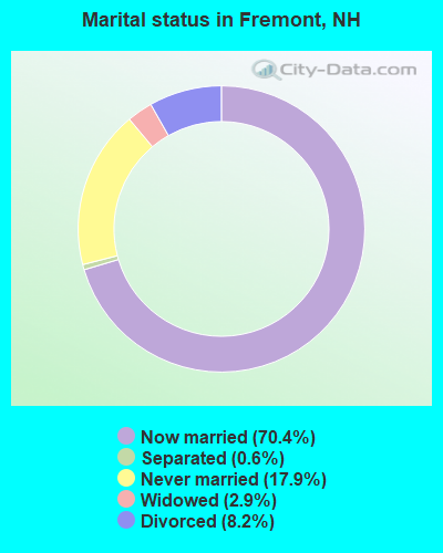
- Never married: 17.9%
- Now married: 70.4%
- Separated: 0.6%
- Widowed: 2.9%
- Divorced: 8.2%
For population 25 years and over in Fremont:
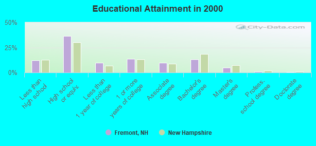
- High school or higher: 88.0%
- Bachelor's degree or higher: 18.7%
- Graduate or professional degree: 5.9%
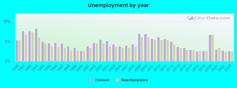
- Unemployed: 1.3%
- Mean travel time to work (commute): 33.8 minutes
| Here: | 9.8 |
| New Hampshire average: | 10.9 |


Graphs represent county-level data. Detailed 2008 Election Results
Religion statistics for Fremont, NH (based on Rockingham County data)


| Religion | Adherents | Congregations |
|---|---|---|
| Catholic | 84,697 | 24 |
| Mainline Protestant | 19,072 | 78 |
| Evangelical Protestant | 7,456 | 61 |
| Other | 3,490 | 20 |
| Orthodox | 200 | 1 |
| None | 180,308 | - |
Food Environment Statistics:
| Rockingham County: | 1.59 / 10,000 pop. |
| State: | 2.14 / 10,000 pop. |
| This county: | 0.17 / 10,000 pop. |
| New Hampshire: | 0.15 / 10,000 pop. |
| Here: | 1.86 / 10,000 pop. |
| New Hampshire: | 1.78 / 10,000 pop. |
| Rockingham County: | 3.31 / 10,000 pop. |
| New Hampshire: | 4.02 / 10,000 pop. |
| This county: | 9.56 / 10,000 pop. |
| State: | 9.70 / 10,000 pop. |
| Rockingham County: | 7.6% |
| State: | 7.6% |
| Rockingham County: | 23.3% |
| State: | 24.4% |
| Rockingham County: | 16.8% |
| New Hampshire: | 15.9% |
7.69% of this county's 2021 resident taxpayers lived in other counties in 2020 ($114,534 average adjusted gross income)
| Here: | 7.69% |
| New Hampshire average: | 7.66% |
0.01% of residents moved from foreign countries ($203 average AGI)
Rockingham County: 0.01% New Hampshire average: 0.01%
Top counties from which taxpayers relocated into this county between 2020 and 2021:
| from Essex County, MA | |
| from Hillsborough County, NH | |
| from Middlesex County, MA |
6.82% of this county's 2020 resident taxpayers moved to other counties in 2021 ($88,778 average adjusted gross income)
| Here: | 6.82% |
| New Hampshire average: | 6.80% |
0.01% of residents moved to foreign countries ($126 average AGI)
Rockingham County: 0.01% New Hampshire average: 0.01%
Top counties to which taxpayers relocated from this county between 2020 and 2021:
| to Hillsborough County, NH | |
| to Strafford County, NH | |
| to Essex County, MA |
Strongest AM radio stations in Fremont:
- WRKO (680 AM; 50 kW; BOSTON, MA; Owner: ENTERCOM BOSTON LICENSE, LLC)
- WDER (1320 AM; 10 kW; DERRY, NH; Owner: BLOUNT COMMUNICATIONS, INC. OF NH)
- WGIP (1540 AM; 5 kW; EXETER, NH; Owner: CAPSTAR TX LIMITED PARTNERSHIP)
- WEEI (850 AM; 50 kW; BOSTON, MA; Owner: ENTERCOM BOSTON LICENSE, LLC)
- WGIR (610 AM; 5 kW; MANCHESTER, NH; Owner: CAPSTAR TX LIMITED PARTNERSHIP)
- WGIN (930 AM; 10 kW; ROCHESTER, NH; Owner: CAPSTAR TX LIMITED PARTNERSHIP)
- WWZN (1510 AM; 50 kW; BOSTON, MA; Owner: ROSE CITY RADIO CORPORATION)
- WBZ (1030 AM; 50 kW; BOSTON, MA; Owner: INFINITY BROADCASTING OPERATIONS, INC.)
- WKOX (1200 AM; 50 kW; FRAMINGHAM, MA; Owner: CAPSTAR TX LIMITED PARTNERSHIP)
- WCEC (1110 AM; daytime; 5 kW; SALEM, NH; Owner: COSTA-EAGLE RADIO VENTURES LTD PARTNERSHIP)
- WBIX (1060 AM; 40 kW; NATICK, MA; Owner: LANGER BROADCASTING CORPORATION)
- WCRN (830 AM; 50 kW; WORCESTER, MA; Owner: CARTER BROADCASTING CORPORATION)
- WFEA (1370 AM; 5 kW; MANCHESTER, NH; Owner: SAGA COMMUNICATIONS OF NEW ENGLAND, LLC)
Strongest FM radio stations in Fremont:
- WXRV (92.5 FM; HAVERHILL, MA; Owner: BEANPOT BROADCASTING CORP.)
- WGIR-FM (101.1 FM; MANCHESTER, NH; Owner: CAPSTAR TX LIMITED PARTNERSHIP)
- WQLL (96.5 FM; BEDFORD, NH; Owner: SAGA COMMUNICATIONS OF NEW ENGLAND, LLC)
- WLMW (90.7 FM; MANCHESTER, NH; Owner: KNOWLEDGE FOR LIFE)
- WZID (95.7 FM; MANCHESTER, NH; Owner: SAGA COMMUNICATIONS OF NEW ENGLAND, LLC)
- WNEF (91.7 FM; NEWBURYPORT, MA; Owner: UNIVERSITY OF MASSACHUSETTS)
- WERZ (107.1 FM; EXETER, NH; Owner: CAPSTAR TX LIMITED PARTNERSHIP)
- WSAK (102.1 FM; HAMPTON, NH; Owner: CITADEL BROADCASTING COMPANY)
- WFEX (92.1 FM; PETERBOROUGH, NH; Owner: FNX BROADCASTING OF NEW HAMPSHIRE LLC)
- WOKQ (97.5 FM; DOVER, NH; Owner: CITADEL BROADCASTING COMPANY)
- WKLB-FM (99.5 FM; LOWELL, MA; Owner: GREATER BOSTON RADIO, INC.)
- WSCY (106.9 FM; MOULTONBOROUGH, NH; Owner: NORTHEAST COMMUNICATIONS CORPORATION)
- WHEB (100.3 FM; PORTSMOUTH, NH; Owner: CAPSTAR TX LIMITED PARTNERSHIP)
- WHOB (106.3 FM; NASHUA, NH; Owner: TELE-MEDIA COMPANY OF NEW HAMPSHIRE, L.L.C.)
- WNHI (93.3 FM; BELMONT, NH; Owner: CONCORD BROADCASTING, L.L.C.)
- W282AF (104.3 FM; CONCORD, NH; Owner: CONCORD BIBLE FELLOWSHIP)
- WMEX (106.5 FM; FARMINGTON, NH; Owner: WIMMEX, LLC)
- W227AM (93.3 FM; ANDOVER, MA; Owner: GREATER BOSTON RADIO, INC.)
- WHDQ (106.1 FM; CLAREMONT, NH; Owner: GREAT NORTHERN RADIO, L.L.C.)
- WUBB (95.3 FM; YORK CENTER, ME; Owner: CAPSTAR TX LIMITED PARTNERSHIP)
TV broadcast stations around Fremont:
- WHDN-LP (Channel 26; BOSTON, MA; Owner: GUENTER MARKSTEINER)
- WFXZ-CA (Channel 24; BOSTON, MA; Owner: BOSTON BROADCASTING CORP.)
- WENH-TV (Channel 11; DURHAM, NH; Owner: UNIVERSITY OF NEW HAMPSHIRE)
- WMEA-TV (Channel 26; BIDDEFORD, ME; Owner: MAINE PUBLIC BROADCASTING CORP.)
- WCVB-TV (Channel 5; BOSTON, MA; Owner: WCVB HEARST-ARGYLE TV, INC.)
- WGBH-TV (Channel 2; BOSTON, MA; Owner: WGBH EDUCATIONAL FOUNDATION)
- WMFP (Channel 62; LAWRENCE, MA; Owner: WSAH LICENSE, INC.)
- WNDS (Channel 50; DERRY, NH; Owner: CTV OF DERRY, INC)
- WUTF (Channel 66; MARLBOROUGH, MA; Owner: TELEFUTURA BOSTON LLC)
- WBZ-TV (Channel 4; BOSTON, MA; Owner: VIACOM INC.)
- WGBX-TV (Channel 44; BOSTON, MA; Owner: WGBH EDUCATIONAL FOUNDATION)
- WSBK-TV (Channel 38; BOSTON, MA; Owner: VIACOM INC.)
- WLVI-TV (Channel 56; CAMBRIDGE, MA; Owner: WLVI, INC.)
- WFXT (Channel 25; BOSTON, MA; Owner: FOX TELEVISION STATIONS INC.)
- WBPX (Channel 68; BOSTON, MA; Owner: PAXSON BOSTON-68 LICENSE, INC.)
- WPXG (Channel 21; CONCORD, NH; Owner: PAXSON BOSTON-68 LICENSE, INC.)
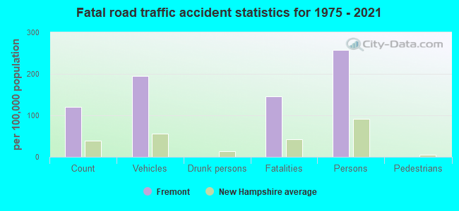
Fremont fatal accident list:
Dec 7, 2008 09:57 PM, Beede Hill Rd, Lat: 42.989390, Lon: -71.129290, Vehicles: 1, Persons: 2, Fatalities: 2
Nov 18, 1992 02:05 PM, Sr107, Vehicles: 2, Persons: 2, Fatalities: 1
Sep 7, 1991 11:21 AM, Sr107, Vehicles: 2, Persons: 3, Fatalities: 1
- National Bridge Inventory (NBI) Statistics
- 3Number of bridges
- 16ft / 5.3mTotal length
- $9,426,000Total costs
- 4,806Total average daily traffic
- 351Total average daily truck traffic
- 7,112Total future (year 2042) average daily traffic
FCC Registered Antenna Towers:
10 (See the full list of FCC Registered Antenna Towers in Fremont)FCC Registered Broadcast Land Mobile Towers:
4- Fire Station Rt 107 (Lat: 42.988694 Lon: -71.138389), Call Sign: KRI738, Licensee ID: L00008549,
Assigned Frequencies: 31.9000 MHz, Grant Date: 08/08/2001, Expiration Date: 09/18/2011, Cancellation Date: 11/19/2003, Registrant: The State Of New Hampshire, Department Of Resources And Economic Development, 172 Pembroke Road, Concord, NH 03302-1856, Phone: (603) 271-2217, Fax: (603) 271-6488, Email:
- Home Of Clarence Philbrick (Lat: 42.994250 Lon: -71.145333), Call Sign: KRI739, Licensee ID: L00008549,
Assigned Frequencies: 31.9000 MHz, Grant Date: 08/08/2001, Expiration Date: 09/18/2011, Cancellation Date: 11/19/2003, Registrant: The State Of New Hampshire, Department Of Resources And Economic Development, 172 Pembroke Road, Concord, NH 03302-1856, Phone: (603) 271-2217, Fax: (603) 271-6488, Email:
- Hazelton Garage Raymond Rd (Lat: 42.991194 Lon: -71.143667), Call Sign: KCE749, Licensee ID: L00008549,
Assigned Frequencies: 31.9000 MHz, Grant Date: 08/08/2001, Expiration Date: 09/18/2011, Cancellation Date: 11/19/2003, Registrant: The State Of New Hampshire, Department Of Resources And Economic Development, 172 Pembroke Road, Concord, NH 03302-1856, Phone: (603) 271-2217, Fax: (603) 271-6488, Email:
- Lat: 42.985333 Lon: -71.129944, Call Sign: WRJV628,
Assigned Frequencies: 159.975 MHz, Grant Date: 11/03/2020, Expiration Date: 11/03/2030, Certifier: Sharon Devincent, Registrant: 2-Way Communications Service, Inc., 19 Durham Street, Portsmouth, NH 03801-2872, Phone: (603) 431-6288, Email:
FCC Registered Microwave Towers:
1- FREMONT, Beede Hill Rd (Lat: 43.010833 Lon: -71.119778), Structure height: 54.6 m, Overall height: 56.1 m, Call Sign: WPOQ343,
Assigned Frequencies: 10551.2 MHz, Grant Date: 12/01/1998, Expiration Date: 12/01/2008, Cancellation Date: 07/24/2001, Phone: (908) 306-6889
FCC Registered Amateur Radio Licenses:
44 (See the full list of FCC Registered Amateur Radio Licenses in Fremont)FAA Registered Aircraft:
3- Aircraft: AERONCA 7CCM (Category: Land, Seats: 2, Weight: Up to 12,499 Pounds, Speed: 90 mph), Engine: CONT MOTOR C90 SERIES (95 HP) (Reciprocating)
N-Number: 2053E, N2053E, N-2053E, Serial Number: 7AC-5623, Year manufactured: 1946, Airworthiness Date: 06/12/1956, Certificate Issue Date: 09/11/2007
Registrant (LLC): Ferwerda Beech LLC, 37 Tarah Dr, Fremont, NH 03044 - Aircraft: AVIAT AIRCRAFT INC S-2C (Category: Land, Seats: 2, Weight: Up to 12,499 Pounds), Engine: LYCOMING AEIO-540 SER (260 HP) (Reciprocating)
N-Number: 325BF, N325BF, N-325BF, Serial Number: 6051, Year manufactured: 2002, Airworthiness Date: 03/29/2002, Certificate Issue Date: 08/29/2020
Registrant (Individual): R Beaudry Brian, 36 Kelsey Dr, Fremont, NH 03044 - Aircraft: BEECH S35 (Category: Land, Seats: 6, Weight: Up to 12,499 Pounds, Speed: 150 mph), Engine: CONT MOTOR IO 520 SERIES (285 HP) (Reciprocating)
N-Number: 8803M, N8803M, N-8803M, Serial Number: D-7328, Year manufactured: 1964, Airworthiness Date: 01/31/1964, Certificate Issue Date: 06/17/2019
Registrant (LLC): Ferwerda Beech LLC, 37 Tarah Way, Fremont, NH 03044
2002 - 2018 National Fire Incident Reporting System (NFIRS) incidents
- Fire incident types reported to NFIRS in Fremont, NH
- 19254.9%Structure Fires
- 11733.4%Outside Fires
- 216.0%Mobile Property/Vehicle Fires
- 205.7%Other
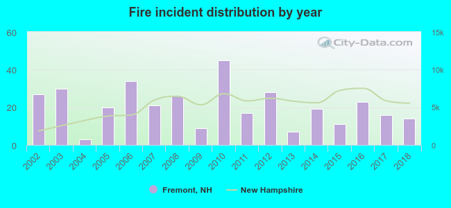 According to the data from the years 2002 - 2018 the average number of fires per year is 21. The highest number of reported fire incidents - 45 took place in 2010, and the least - 3 in 2004. The data has a decreasing trend.
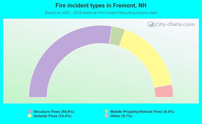 When looking into fire subcategories, the most reports belonged to: Structure Fires (54.9%), and Outside Fires (33.4%).
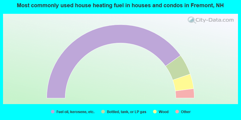
- 80.3%Fuel oil, kerosene, etc.
- 9.1%Bottled, tank, or LP gas
- 6.5%Wood
- 3.0%Electricity
- 0.8%Utility gas
- 0.3%Coal or coke
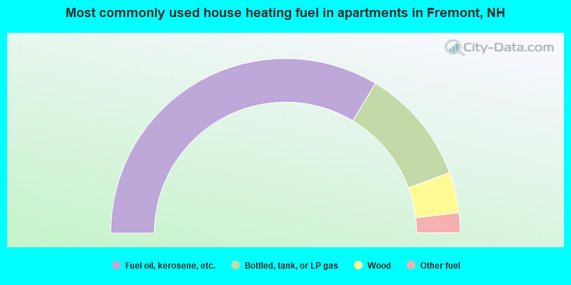
- 67.2%Fuel oil, kerosene, etc.
- 21.6%Bottled, tank, or LP gas
- 7.5%Wood
- 3.7%Other fuel
Fremont compared to New Hampshire state average:
- Unemployed percentage significantly below state average.
- Black race population percentage significantly below state average.
- Hispanic race population percentage significantly below state average.
- Foreign-born population percentage significantly below state average.
- Renting percentage significantly below state average.
- Length of stay since moving in significantly above state average.
- Number of rooms per house significantly below state average.
- House age significantly below state average.
- Percentage of population with a bachelor's degree or higher below state average.

|
|
Total of 27 patent applications in 2008-2024.