Ellsworth, Maine
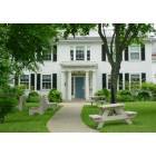
Ellsworth: Ellsworth Public Library, Ellsworth
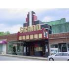
Ellsworth: Grand Auditorium, Ellsworth
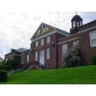
Ellsworth: City Hall, Ellsworth
Ellsworth: Union River, Ellsworth
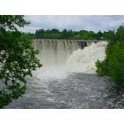
Ellsworth: Union River hydro dam, Ellsworth
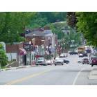
Ellsworth: Main Street, Ellsworth
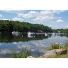
Ellsworth: S.K. Whiting Park, Ellsworth

Ellsworth

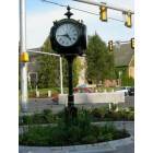
Ellsworth
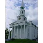
Ellsworth: Congregational Church, Ellsworth
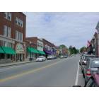
Ellsworth: Main Street, Ellsworth
- add
your
Submit your own pictures of this city and show them to the world
- OSM Map
- General Map
- Google Map
- MSN Map

Population change since 2000: +35.3%
 |
| Males: 4,159 | |
| Females: 4,573 |
| Median resident age: | 43.8 years |
| Maine median age: | 45.1 years |
Zip codes: 04605.
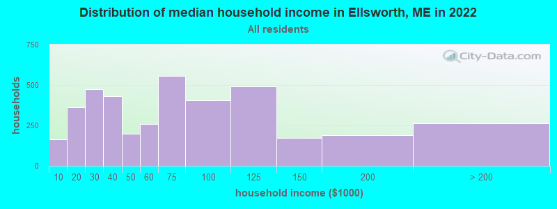
| Ellsworth: | $62,392 |
| ME: | $69,543 |
Estimated per capita income in 2022: $35,516 (it was $21,049 in 2000)
Ellsworth city income, earnings, and wages data
Estimated median house or condo value in 2022: $233,501 (it was $101,000 in 2000)
| Ellsworth: | $233,501 |
| ME: | $290,600 |
Mean prices in 2022: all housing units: $276,806; detached houses: $295,890; mobile homes: $100,182
Median gross rent in 2022: $906.
(9.9% for White Non-Hispanic residents, 3.5% for Black residents, 54.8% for Hispanic or Latino residents)
Detailed information about poverty and poor residents in Ellsworth, ME


Compare current foreclosures near Ellsworth, ME:
| Photo | Address | Area | Beds / Baths | Price | Details |
|---|---|---|---|---|---|

|
#1
Mariaville Rd
Ellsworth, ME 04605
|
- sq. feet
|
- baths - beds |
show details | |

|
#2
Surry Rd
Orland, ME 04472
|
- sq. feet
|
4 baths 5 beds |
$174,900
|
show details |

|
#3
Central St
Bucksport, ME 04416
|
- sq. feet
|
- baths - beds |
$63,000
|
show details |

|
#4
Earles Way
Hancock, ME 04640
|
- sq. feet
|
- baths - beds |
show details | |

|
#5
Front Ridge Rd
Penobscot, ME 04476
|
- sq. feet
|
- baths - beds |
show details | |

|
#6
Merrill Rd
Penobscot, ME 04476
|
- sq. feet
|
- baths - beds |
show details | |

|
#7
Gott Brook Hts
Orland, ME 04472
|
- sq. feet
|
- baths - beds |
show details | |

|
#8
Railroad Ln
Holden, ME 04429
|
- sq. feet
|
- baths - beds |
show details | |

|
#9
Central St
Bucksport, ME 04416
|
- sq. feet
|
- baths - beds |
show details | |

|
#10
Hinks St
Bucksport, ME 04416
|
- sq. feet
|
- baths - beds |
show details |
| Photo | Address | Area | Beds / Baths | Price | Details |
|---|---|---|---|---|---|

|
#11
Merrill Rd
Eddington, ME 04428
|
- sq. feet
|
- baths - beds |
show details | |

|
Check over 1 million property listings on Foreclosure.com!
|
browse all offers | |||


- 7,76190.3%White alone
- 1962.3%Two or more races
- 1742.0%Other race alone
- 1511.8%Hispanic
- 1341.6%Asian alone
- 861.0%Black alone
- 800.9%American Indian alone

Races in Ellsworth detailed stats: ancestries, foreign born residents, place of birth
According to our research of Maine and other state lists, there were 16 registered sex offenders living in Ellsworth, Maine as of May 04, 2024.
The ratio of all residents to sex offenders in Ellsworth is 493 to 1.
The ratio of registered sex offenders to all residents in this city is near the state average.
Type |
2009 |
2010 |
2011 |
2012 |
2013 |
2014 |
2015 |
2016 |
2017 |
2018 |
2019 |
2020 |
2021 |
2022 |
|---|---|---|---|---|---|---|---|---|---|---|---|---|---|---|
| Murders (per 100,000) | 0 (0.0) | 0 (0.0) | 0 (0.0) | 0 (0.0) | 1 (12.7) | 0 (0.0) | 0 (0.0) | 0 (0.0) | 0 (0.0) | 0 (0.0) | 0 (0.0) | 0 (0.0) | 0 (0.0) | 0 (0.0) |
| Rapes (per 100,000) | 1 (13.9) | 1 (12.9) | 0 (0.0) | 1 (12.9) | 0 (0.0) | 1 (12.6) | 3 (38.1) | 1 (12.7) | 0 (0.0) | 4 (50.0) | 5 (61.8) | 2 (24.3) | 5 (60.2) | 7 (80.7) |
| Robberies (per 100,000) | 0 (0.0) | 4 (51.7) | 1 (12.9) | 3 (38.6) | 1 (12.7) | 2 (25.3) | 2 (25.4) | 2 (25.4) | 0 (0.0) | 1 (12.5) | 0 (0.0) | 1 (12.1) | 0 (0.0) | 2 (23.1) |
| Assaults (per 100,000) | 2 (27.9) | 10 (129.2) | 3 (38.8) | 3 (38.6) | 3 (38.2) | 3 (37.9) | 8 (101.7) | 3 (38.1) | 5 (63.0) | 1 (12.5) | 1 (12.4) | 5 (60.7) | 2 (24.1) | 4 (46.1) |
| Burglaries (per 100,000) | 39 (543.4) | 36 (465.1) | 41 (529.7) | 30 (386.1) | 57 (725.8) | 41 (518.3) | 48 (609.9) | 31 (393.4) | 28 (352.6) | 9 (112.4) | 11 (136.0) | 9 (109.3) | 9 (108.4) | 5 (57.6) |
| Thefts (per 100,000) | 263 (3,664) | 219 (2,829) | 225 (2,907) | 214 (2,754) | 209 (2,661) | 290 (3,666) | 250 (3,177) | 204 (2,589) | 241 (3,035) | 173 (2,160) | 153 (1,892) | 165 (2,005) | 132 (1,590) | 293 (3,377) |
| Auto thefts (per 100,000) | 13 (181.1) | 8 (103.3) | 11 (142.1) | 3 (38.6) | 8 (101.9) | 7 (88.5) | 5 (63.5) | 7 (88.8) | 2 (25.2) | N/A | 10 (123.6) | 4 (48.6) | 13 (156.6) | 5 (57.6) |
| Arson (per 100,000) | 0 (0.0) | 0 (0.0) | 0 (0.0) | 0 (0.0) | 0 (0.0) | 0 (0.0) | 0 (0.0) | 0 (0.0) | 0 (0.0) | 0 (0.0) | 0 (0.0) | 1 (12.1) | 1 (12.0) | 0 (0.0) |
| City-Data.com crime index | 215.8 | 205.7 | 176.4 | 169.9 | 202.3 | 215.3 | 233.3 | 163.6 | 160.7 | 142.5 | 147.0 | 127.0 | 136.7 | 224.4 |
The City-Data.com crime index weighs serious crimes and violent crimes more heavily. Higher means more crime, U.S. average is 246.1. It adjusts for the number of visitors and daily workers commuting into cities.
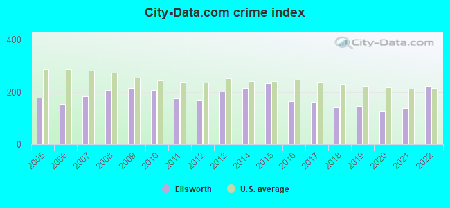
Crime rate in Ellsworth detailed stats: murders, rapes, robberies, assaults, burglaries, thefts, arson
Full-time law enforcement employees in 2021, including police officers: 23 (20 officers - 19 male; 1 female).
| Officers per 1,000 residents here: | 2.41 |
| Maine average: | 1.71 |
 Recent articles from our blog. Our writers, many of them Ph.D. graduates or candidates, create easy-to-read articles on a wide variety of topics.

 | Possible Ellsworth Relocation/Retirement (17 replies) |
| What's fun to do in Blue Hill and Ellsworth? (12 replies) |
| Belfast, Ellsworth, or Bangor (8 replies) |
| cdl or hvac jobs near Ellsworth, ME (3 replies) |
| Year round living in Maine. (137 replies) |
| What are you doing? (74 replies) |
Latest news from Ellsworth, ME collected exclusively by city-data.com from local newspapers, TV, and radio stations
Ellsworth, ME City Guides:
Ancestries: English (22.1%), Irish (12.3%), American (9.4%), French Canadian (6.1%), French (6.0%), European (5.7%).
Current Local Time: EST time zone
Incorporated on 02/26/1800
Elevation: 113 feet
Land area: 79.3 square miles.
Population density: 110 people per square mile (very low).
298 residents are foreign born (1.6% Asia, 1.1% Europe, 0.5% North America).
| This city: | 3.5% |
| Maine: | 3.8% |
Median real estate property taxes paid for housing units with mortgages in 2022: $2,865 (1.2%)
Median real estate property taxes paid for housing units with no mortgage in 2022: $2,631 (1.3%)
Nearest city with pop. 50,000+: Portland, ME  (108.9 miles , pop. 64,249).
Nearest city with pop. 200,000+: Boston, MA (203.6 miles , pop. 589,141).
Nearest city with pop. 1,000,000+: Bronx, NY (376.2 miles , pop. 1,332,650).
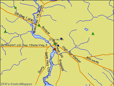
Nearest cities:
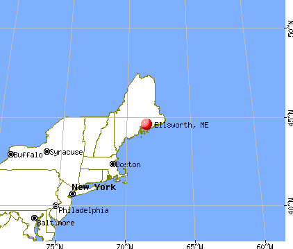
), ), ), Latitude: 44.57 N, Longitude: 68.48 W
Daytime population change due to commuting: +2,693 (+31.3%)
Workers who live and work in this city: 2,739 (62.1%)
Area code: 207

Ellsworth, Maine accommodation & food services, waste management - Economy and Business Data
Single-family new house construction building permits:
- 2022: 35 buildings, average cost: $259,300
- 2021: 63 buildings, average cost: $266,700
- 2020: 28 buildings, average cost: $236,800
- 2019: 26 buildings, average cost: $272,400
- 2018: 29 buildings, average cost: $210,800
- 2017: 16 buildings, average cost: $172,200
- 2016: 26 buildings, average cost: $189,400
- 2015: 23 buildings, average cost: $198,300
- 2014: 19 buildings, average cost: $179,500
- 2013: 11 buildings, average cost: $204,500
- 2012: 16 buildings, average cost: $140,100
- 2011: 16 buildings, average cost: $144,600
- 2010: 18 buildings, average cost: $133,100
- 2009: 27 buildings, average cost: $158,100
- 2008: 31 buildings, average cost: $165,300
- 2007: 65 buildings, average cost: $198,100
- 2006: 76 buildings, average cost: $144,400
- 2005: 86 buildings, average cost: $121,800
- 2004: 89 buildings, average cost: $129,000
- 2003: 81 buildings, average cost: $122,100
- 2002: 62 buildings, average cost: $117,800
- 2001: 57 buildings, average cost: $109,300
- 2000: 42 buildings, average cost: $94,900
- 1999: 48 buildings, average cost: $99,300
- 1998: 45 buildings, average cost: $78,500
- 1997: 48 buildings, average cost: $71,400
| Here: | 4.6% |
| Maine: | 3.4% |
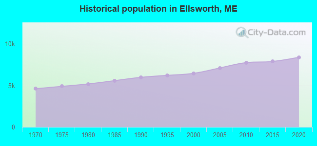
Population change in the 1990s: +454 (+7.6%).
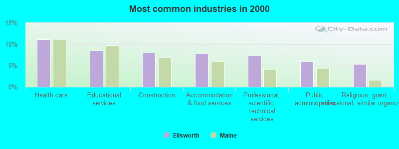
- Health care (11.1%)
- Educational services (8.5%)
- Construction (8.0%)
- Accommodation & food services (7.8%)
- Professional, scientific, technical services (7.3%)
- Public administration (6.0%)
- Religious, grantmaking, civic, professional, similar organizations (5.3%)
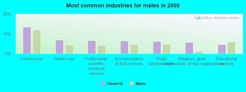
- Construction (13.5%)
- Health care (7.0%)
- Professional, scientific, technical services (6.6%)
- Accommodation & food services (6.4%)
- Public administration (6.2%)
- Religious, grantmaking, civic, professional, similar organizations (5.8%)
- Educational services (4.6%)

- Health care (15.6%)
- Educational services (12.6%)
- Accommodation & food services (9.3%)
- Professional, scientific, technical services (8.0%)
- Social assistance (5.7%)
- Public administration (5.7%)
- Religious, grantmaking, civic, professional, similar organizations (4.9%)

- Other sales and related occupations, including supervisors (6.3%)
- Building and grounds cleaning and maintenance occupations (5.6%)
- Other office and administrative support workers, including supervisors (5.4%)
- Other management occupations, except farmers and farm managers (4.6%)
- Preschool, kindergarten, elementary, and middle school teachers (3.6%)
- Cooks and food preparation workers (2.9%)
- Counselors, social workers, and other community and social service specialists (2.9%)
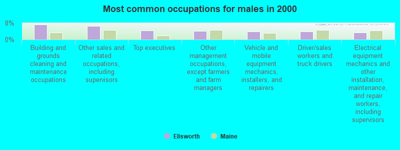
- Building and grounds cleaning and maintenance occupations (7.2%)
- Other sales and related occupations, including supervisors (6.4%)
- Top executives (4.3%)
- Other management occupations, except farmers and farm managers (4.1%)
- Vehicle and mobile equipment mechanics, installers, and repairers (3.9%)
- Driver/sales workers and truck drivers (3.8%)
- Electrical equipment mechanics and other installation, maintenance, and repair workers, including supervisors (3.3%)

- Other office and administrative support workers, including supervisors (9.0%)
- Preschool, kindergarten, elementary, and middle school teachers (7.5%)
- Other sales and related occupations, including supervisors (6.1%)
- Secretaries and administrative assistants (5.4%)
- Other management occupations, except farmers and farm managers (5.1%)
- Registered nurses (3.9%)
- Waiters and waitresses (3.9%)
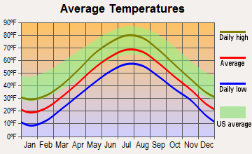
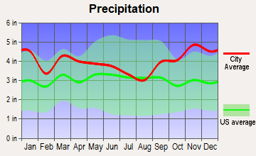
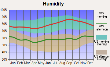
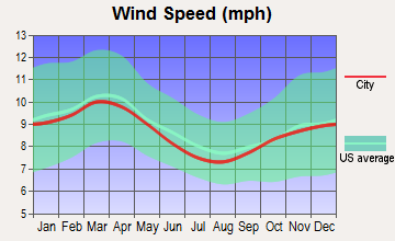
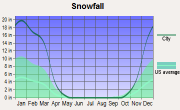
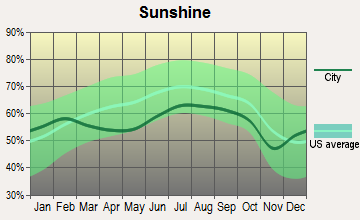
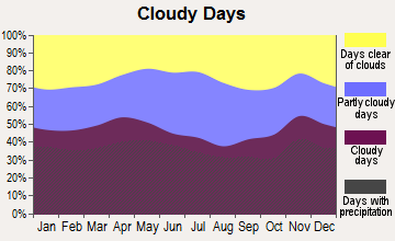
Average climate in Ellsworth, Maine
Based on data reported by over 4,000 weather stations
|
|

(lower is better)
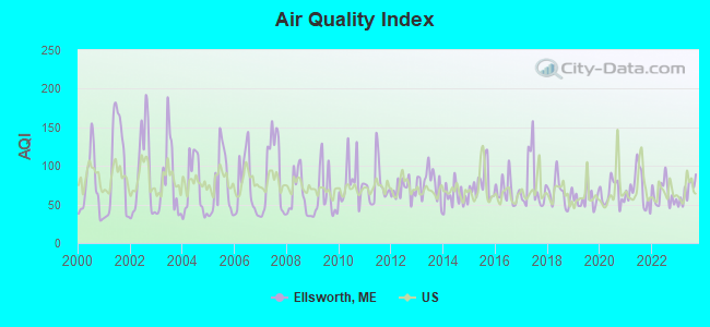
Air Quality Index (AQI) level in 2023 was 66.6. This is about average.
| City: | 66.6 |
| U.S.: | 72.6 |
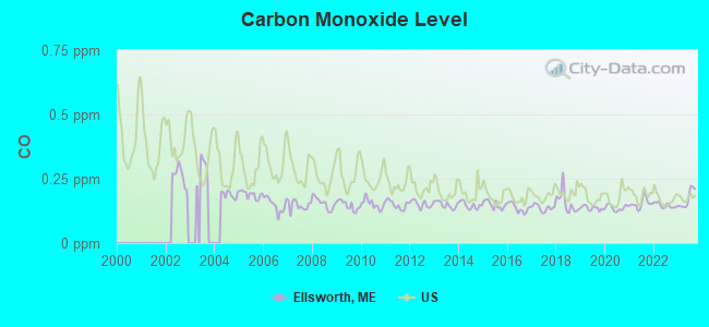
Carbon Monoxide (CO) [ppm] level in 2023 was 0.172. This is significantly better than average. Closest monitor was 8.6 miles away from the city center.
| City: | 0.172 |
| U.S.: | 0.251 |
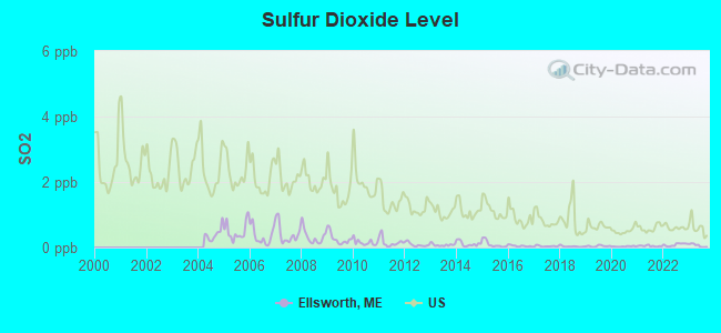
Sulfur Dioxide (SO2) [ppb] level in 2023 was 0.0636. This is significantly better than average. Closest monitor was 8.6 miles away from the city center.
| City: | 0.0636 |
| U.S.: | 1.5147 |
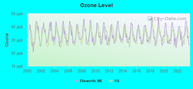
Ozone [ppb] level in 2023 was 35.8. This is about average. Closest monitor was 8.6 miles away from the city center.
| City: | 35.8 |
| U.S.: | 33.3 |
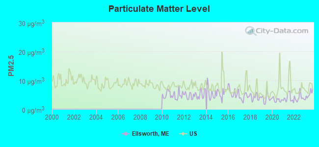
Particulate Matter (PM2.5) [µg/m3] level in 2023 was 5.16. This is significantly better than average. Closest monitor was 17.2 miles away from the city center.
| City: | 5.16 |
| U.S.: | 8.11 |
Earthquake activity:
Ellsworth-area historical earthquake activity is significantly above Maine state average. It is 80% smaller than the overall U.S. average.On 10/16/2012 at 23:12:25, a magnitude 4.7 (4.7 ML, Depth: 10.0 mi, Class: Light, Intensity: IV - V) earthquake occurred 127.6 miles away from Ellsworth center
On 4/20/2002 at 10:50:47, a magnitude 5.3 (5.3 ML, Depth: 3.0 mi, Class: Moderate, Intensity: VI - VII) earthquake occurred 257.4 miles away from the city center
On 4/20/2002 at 10:50:47, a magnitude 5.2 (5.2 MB, 4.2 MS, 5.2 MW, 5.0 MW) earthquake occurred 258.5 miles away from the city center
On 1/19/1982 at 00:14:42, a magnitude 4.7 (4.5 MB, 4.7 MD, 4.5 LG) earthquake occurred 172.1 miles away from Ellsworth center
On 10/7/1983 at 10:18:46, a magnitude 5.3 (5.1 MB, 5.3 LG, 5.1 ML) earthquake occurred 293.6 miles away from the city center
On 10/3/2006 at 00:07:38, a magnitude 3.7 (3.7 MD, Depth: 6.2 mi, Class: Light, Intensity: II - III) earthquake occurred 21.6 miles away from the city center
Magnitude types: regional Lg-wave magnitude (LG), body-wave magnitude (MB), duration magnitude (MD), local magnitude (ML), surface-wave magnitude (MS), moment magnitude (MW)
Natural disasters:
The number of natural disasters in Hancock County (18) is near the US average (15).Major Disasters (Presidential) Declared: 11
Emergencies Declared: 6
Causes of natural disasters: Floods: 9, Storms: 8, Snows: 5, Blizzard: 1, Heavy Rain: 1, Hurricane: 1, Ice Storm: 1, Landslide: 1, Snowfall: 1, Wind: 1, Winter Storm: 1, Other: 2 (Note: some incidents may be assigned to more than one category).

Main business address for: UNION BANKSHARES CO/ME (STATE COMMERCIAL BANKS).
Hospitals and medical centers in Ellsworth:
Airports located in Ellsworth:
- Philbrick Mountain Airport (72ME) (Runways: 1)
Colleges/universities with over 2000 students nearest to Ellsworth:
- Husson University (about 24 miles; Bangor, ME; Full-time enrollment: 2,421)
- University of Maine (about 25 miles; Orono, ME; FT enrollment: 8,931)
- University of Maine at Augusta (about 68 miles; Augusta, ME; FT enrollment: 3,204)
- University of Maine at Farmington (about 83 miles; Farmington, ME; FT enrollment: 2,036)
- Southern Maine Community College (about 108 miles; South Portland, ME; FT enrollment: 4,666)
- University of Southern Maine (about 110 miles; Portland, ME; FT enrollment: 6,647)
- Saint Joseph's College of Maine (about 113 miles; Standish, ME; FT enrollment: 2,010)
Public high school in Ellsworth:
- ELLSWORTH HIGH SCHOOL (Students: 610, Location: 299 STATE STREET, Grades: 9-12)
Private high school in Ellsworth:
Public elementary/middle school in Ellsworth:
User-submitted facts and corrections:
- Please add under 'strongest FM stations in Ellsworth, ME': W221B0 92.1 FM Ellsworth, ME; Owner: Bangor Baptist Church
Points of interest:
Notable locations in Ellsworth: Timberland Acres Recreational Vehicle Park (A), Camp Dry-Kye (B), Patten Pond Camping Resort (C), Green Lake National Fish Hatchery (D), Nicolin Siding (E), Hansons Landing on Branch Lake (F), Green Lake National Fish Hatchery (G), Branch Lake Camping Area (H), Ellsworth City Hall (I), Ellsworth Fire Station (J), Ellsworth Historical Society Building (K), Ellsworth Power House (L), Ellsworth Public Library (M), Federal Building (N), Hancock County Auditorium (O), Hancock County Cooperative Extension Service Building (P), Hancock County Courthouse (Q), Hancock County Law Library (R), Hancock County Regional Planning Commission (S), Maine Department of Social Services (T). Display/hide their locations on the map
Shopping Centers: Puffin Square Mall Shopping Center (1), Maine Coast Mall Shopping Center (2), Ellsworth Shopping Center (3). Display/hide their locations on the map
Main business address in Ellsworth: UNION BANKSHARES CO/ME (A). Display/hide its location on the map
Churches in Ellsworth include: Full Gospel Church (A), Union Congregational Church of Ellsworth Falls (B), Unitarian Universalist Church (C), United Baptist Church (D), Ellsworth Church (E), Ellsworth United Methodist Church (F), Emmanuel Baptist Church (G), Family Bible Church (H), First Church of Christ Scientist (I). Display/hide their locations on the map
Cemeteries: North Ellsworth Cemetery (1), Old Burying Ground Cemetery (2), Remick Cemetery (3), Birch Grove Cemetery (4), Jordan Cemetery (5), Juniper Cemetery (6), Whittenmore Cemetery (7). Display/hide their locations on the map
Lakes, reservoirs, and swamps: Wormwood Pond (A), Big Pond (B), Mill Pond (C), Upper Patten Pond (D), Jesse Bog (E), Little Duck Pond (F), Little Rocky Pond (G), Upper Patten Pond (H). Display/hide their locations on the map
Streams, rivers, and creeks: Shackford Brook (A), Sawpit Brook (B), Winkumpaugh Brook (C), Gott Brook (D), Whittaker Brook (E), John Gray Brook (F), Mill Brook (G), Carters Brook (H), Mink Brook (I). Display/hide their locations on the map
Parks in Ellsworth include: Stanwood Homestead Museum and Wildlife Sanctuary (1), Ellsworth Waterford Park and Marina (2), Birdsacre Wildlife Sanctuary (3). Display/hide their locations on the map
Beaches: Hales Beach (A), Jesse Beach (B). Display/hide their locations on the map
Tourist attractions: WoodLawn MuseumsBlack House (West Main) (1), Telephone Museum The (Winkumpaugh) (2), Great Maine Lumberjack Show (Arcades & Amusements; 127 Bar Harbor Rd) (3). Display/hide their approximate locations on the map
Hotels: Comfort Inn Ellsworth (130 High Street) (1), The Eagle's Lodge Motel (278 High Street) (2), Sunset Motor Court (210 Twin Hill Rd) (3), Ellsworth Travelodge (Bar Harbor Rd. Rte. 1a And Rte. 3) (4), Ellsworth Motel (24 High Street) (5), Colonial Travelodge (321 High Street) (6), Killarney's Restaurant (215 High Street) (7), Pete & Larry's Lounge (215 High Street) (8), Twilite Motel (147 Bucksport Road) (9). Display/hide their approximate locations on the map
Courts: Hancock County Planning Comm (395 State Street) (1), Sunset Motor Court (210 Twin Hill Road) (2), Maine State - Courts- Superior Court (50 State Street) (3). Display/hide their approximate locations on the map
Birthplace of: Tim Sylvia - Martial artist, Bryant Moore - Army officer, Darryl Pollard - Football player, Frank A. Moore - Politician, Jude Johnstone - Pop singer, Curt Fullerton - Baseball player, Dick Scott (shortstop) - Baseball player.
Drinking water stations with addresses in Ellsworth and their reported violations in the past:
ELLSWORTH WATER DEPARTMENT (Population served: 3,560, Surface water):Past health violations:TIMBERLAND ACRES CAMPGROUND (Population served: 572, Groundwater):
- MCL, Monthly (TCR) - In SEP-2013, Contaminant: Coliform. Follow-up actions: St Public Notif requested (OCT-02-2013), St Formal NOV issued (OCT-02-2013), St Public Notif received (OCT-31-2013), St Compliance achieved (DEC-09-2013)
- MCL, Average - Between JUL-2013 and SEP-2013, Contaminant: TTHM. Follow-up actions: St Formal NOV issued (OCT-16-2013), St Public Notif requested (OCT-16-2013)
- MCL, Average - Between APR-2013 and JUN-2013, Contaminant: TTHM. Follow-up actions: St Public Notif requested (JUL-23-2013), St Formal NOV issued (JUL-23-2013), St Public Notif received (AUG-19-2013), St Compliance achieved (FEB-03-2014)
- MCL, Monthly (TCR) - In AUG-2012, Contaminant: Coliform. Follow-up actions: St Public Notif requested (SEP-06-2012), St Formal NOV issued (SEP-06-2012), St Compliance achieved (SEP-18-2012), St Public Notif received (OCT-04-2012)
- MCL, Monthly (TCR) - In SEP-2010, Contaminant: Coliform. Follow-up actions: St Public Notif requested (SEP-27-2010), St Formal NOV issued (SEP-27-2010), St Public Notif received (OCT-15-2010), St Compliance achieved (OCT-29-2010)
- MCL, Average - Between JAN-2007 and MAR-2007, Contaminant: Total Haloacetic Acids (HAA5). Follow-up actions: St Public Notif requested (MAY-16-2007), St Violation/Reminder Notice (MAY-16-2007), St Public Notif received (MAY-20-2009), St Compliance achieved (MAY-20-2009)
- 2 other older health violations
Past health violations:RSU 24 HANCOCK GRAMMAR SCHOOL (Population served: 240, Groundwater):Past monitoring violations:
- MCL, Monthly (TCR) - In JUL-2013, Contaminant: Coliform. Follow-up actions: St Public Notif requested (AUG-07-2013), St Formal NOV issued (AUG-07-2013), St Public Notif received (AUG-26-2013)
- 2 routine major monitoring violations
- One regular monitoring violation
Past health violations:HANCOCK HEIGHTS MHP (Population served: 218, Groundwater):Past monitoring violations:
- MCL, Monthly (TCR) - In AUG-2007, Contaminant: Coliform. Follow-up actions: St Public Notif requested (AUG-24-2007), St Formal NOV issued (AUG-24-2007), St Public Notif received (SEP-10-2007), St Compliance achieved (SEP-06-2011), St Intentional no-action (SEP-09-2011)
- One routine major monitoring violation
Past health violations:BEST WESTERN INN (Population served: 188, Groundwater):Past monitoring violations:
- OCCT/SOWT Study/Recommendation - In APR-01-2007, Contaminant: Lead and Copper Rule. Follow-up actions: St Public Notif requested (JUN-07-2007), St Violation/Reminder Notice (JUN-07-2007), St Intentional no-action (AUG-10-2011), St Compliance achieved (AUG-31-2011)
- Public Education - In DEC-10-2006, Contaminant: Lead and Copper Rule. Follow-up actions: St Violation/Reminder Notice (FEB-05-2007), St Compliance achieved (JUN-07-2007)
- Water Quality Parameter M/R - Between JUL-2006 and DEC-2006, Contaminant: Lead and Copper Rule. Follow-up actions: St Public Notif requested (FEB-05-2007), St Violation/Reminder Notice (FEB-05-2007), St Public Notif received (MAR-30-2007), St Compliance achieved (JUN-07-2007)
- 2 routine major monitoring violations
- One minor monitoring violation
- 18 regular monitoring violations
Past health violations:JORDANS SNACK BAR (Population served: 180, Groundwater):Past monitoring violations:
- MCL, Monthly (TCR) - In MAY-2013, Contaminant: Coliform. Follow-up actions: St Public Notif requested (JUL-01-2013), St Formal NOV issued (JUL-01-2013), St Public Notif received (JUL-19-2013)
- MCL, Monthly (TCR) - Between APR-2008 and JUN-2008, Contaminant: Coliform. Follow-up actions: St Public Notif requested (MAY-20-2008), St Formal NOV issued (MAY-20-2008), St Compliance achieved (JUN-11-2008), St Public Notif received (JUN-20-2008)
- 3 routine major monitoring violations
Past monitoring violations:CAMP JORDAN (Population served: 172, Groundwater):
- Monitoring, Repeat Major (TCR) - In OCT-2010, Contaminant: Coliform (TCR). Follow-up actions: St Public Notif requested (NOV-08-2010), St Formal NOV issued (NOV-08-2010), St Public Notif received (APR-05-2012), St Compliance achieved (APR-05-2012)
- 3 routine major monitoring violations
- One minor monitoring violation
Past health violations:EASTWARD BOWLING LANES (Population served: 170, Groundwater):Past monitoring violations:
- MCL, Monthly (TCR) - In SEP-2005, Contaminant: Coliform. Follow-up actions: St Public Notif requested (SEP-23-2005), St Violation/Reminder Notice (SEP-23-2005), St Compliance achieved (JUN-13-2006), St Intentional no-action (AUG-01-2011)
- 5 routine major monitoring violations
Past monitoring violations:
- 15 routine major monitoring violations
- 2 regular monitoring violations
Drinking water stations with addresses in Ellsworth that have no violations reported:
- RSU 24 MOUNTAIN VIEW SCHOOL (Population served: 350, Primary Water Source Type: Groundwater)
- BRANCH LAKE CAMPING AREA (Population served: 150, Primary Water Source Type: Groundwater)
- RSU 24 ELLA LEWIS SCHOOL (Population served: 120, Primary Water Source Type: Groundwater)
- ACADIA GATEWAY-BUS MAINTENANCE FACILITY (Population served: 102, Primary Water Source Type: Groundwater)
- HARRINGTON EARLY CARE & EDUCATION CENTER (Population served: 40, Primary Water Source Type: Groundwater)
| This city: | 2.3 people |
| Maine: | 2.3 people |
| This city: | 62.0% |
| Whole state: | 62.9% |
| This city: | 9.2% |
| Whole state: | 9.4% |
Likely homosexual households (counted as self-reported same-sex unmarried-partner households)
- Lesbian couples: 0.4% of all households
- Gay men: 0.2% of all households
People in group quarters in Ellsworth in 2010:
- 101 people in nursing facilities/skilled-nursing facilities
- 54 people in local jails and other municipal confinement facilities
- 25 people in residential treatment centers for juveniles (non-correctional)
- 21 people in group homes intended for adults
- 10 people in other noninstitutional facilities
- 9 people in emergency and transitional shelters (with sleeping facilities) for people experiencing homelessness
- 6 people in workers' group living quarters and job corps centers
- 4 people in residential treatment centers for adults
People in group quarters in Ellsworth in 2000:
- 106 people in nursing homes
- 48 people in homes for abused, dependent, and neglected children
- 26 people in other noninstitutional group quarters
- 25 people in homes for the mentally retarded
- 24 people in local jails and other confinement facilities (including police lockups)
- 4 people in other group homes
- 2 people in religious group quarters
Banks with branches in Ellsworth (2011 data):
- Machias Savings Bank: Ellsworth Branch at 93 High Street, branch established on 1988/03/28; Ellsworth State Street Branch at 248 State Street, branch established on 2007/09/05. Info updated 2008/08/20: Bank assets: $933.5 mil, Deposits: $794.5 mil, headquarters in Machias, ME, positive income, Commercial Lending Specialization, 13 total offices, Holding Company: Machias Bancorp, Mhc
- The Camden National Bank: Union Trust Branch at 66 Main Street, branch established on 1907/01/01; Plaza Branch at 3 Myrick Street, branch established on 1963/12/02. Info updated 2008/02/27: Bank assets: $2,266.8 mil, Deposits: $1,604.6 mil, headquarters in Camden, ME, positive income, Commercial Lending Specialization, 39 total offices, Holding Company: Camden National Corporation
- The First, N.A.: Ellsworth Branch at 235 High Street, branch established on 1971/04/29. Info updated 2010/06/01: Bank assets: $1,338.8 mil, Deposits: $942.2 mil, headquarters in Damariscotta, ME, positive income, Commercial Lending Specialization, 14 total offices, Holding Company: First Bancorp, Inc., The
- TD Bank, National Association: Ellsworth Branch at 217 High Street, branch established on 1961/07/01. Info updated 2010/10/04: Bank assets: $188,912.6 mil, Deposits: $153,149.8 mil, headquarters in Wilmington, DE, positive income, 1314 total offices, Holding Company: Toronto-Dominion Bank, The
- Bangor Savings Bank: Ellsworth Branch at 59 Foster Street, branch established on 1975/05/28. Info updated 2008/12/02: Bank assets: $2,556.3 mil, Deposits: $1,940.3 mil, headquarters in Bangor, ME, positive income, Commercial Lending Specialization, 58 total offices, Holding Company: Bangor Bancorp, Mhc
- KeyBank National Association: Ellsworth High Street Branch at 162 High Street, branch established on 1970/08/04. Info updated 2008/03/03: Bank assets: $86,198.8 mil, Deposits: $64,214.8 mil, headquarters in Cleveland, OH, positive income, Commercial Lending Specialization, 1067 total offices, Holding Company: Keycorp
- Bar Harbor Bank & Trust: Ellsworth Branch at 137 High Street, branch established on 1981/11/02. Info updated 2007/04/24: Bank assets: $1,166.8 mil, Deposits: $723.6 mil, headquarters in Bar Harbor, ME, positive income, Commercial Lending Specialization, 12 total offices, Holding Company: Bar Harbor Bankshares
For population 15 years and over in Ellsworth:
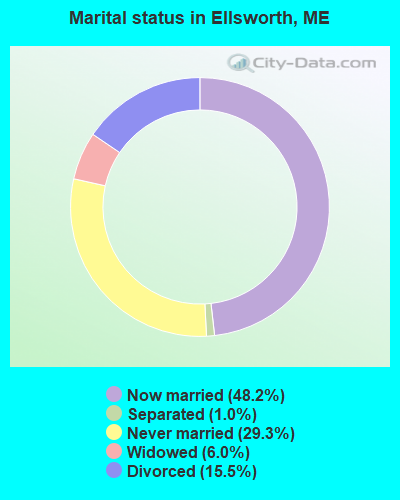
- Never married: 29.3%
- Now married: 48.2%
- Separated: 1.0%
- Widowed: 6.0%
- Divorced: 15.5%
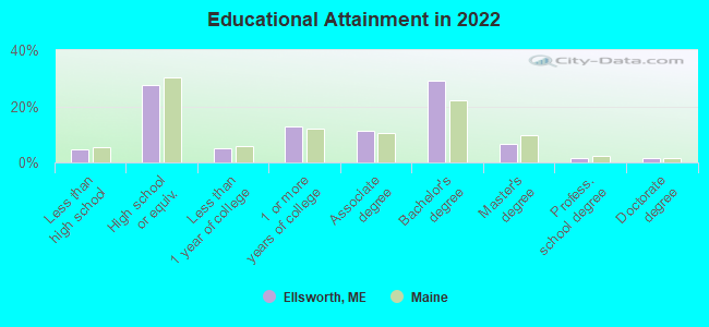
For population 25 years and over in Ellsworth:
- High school or higher: 95.0%
- Bachelor's degree or higher: 37.0%
- Graduate or professional degree: 9.1%
- Unemployed: 3.8%
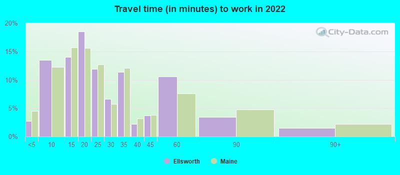
- Mean travel time to work (commute): 20.0 minutes
| Here: | 9.2 |
| Maine average: | 10.3 |


Graphs represent county-level data. Detailed 2008 Election Results
Religion statistics for Ellsworth, ME (based on Hancock County data)


| Religion | Adherents | Congregations |
|---|---|---|
| Mainline Protestant | 4,691 | 58 |
| Catholic | 2,523 | 9 |
| Evangelical Protestant | 1,288 | 23 |
| Other | 820 | 11 |
| None | 45,096 | - |
Food Environment Statistics:
| Hancock County: | 6.01 / 10,000 pop. |
| Maine: | 2.80 / 10,000 pop. |
| Hancock County: | 1.69 / 10,000 pop. |
| Maine: | 2.20 / 10,000 pop. |
| Hancock County: | 4.89 / 10,000 pop. |
| Maine: | 5.75 / 10,000 pop. |
| Here: | 21.61 / 10,000 pop. |
| Maine: | 11.02 / 10,000 pop. |
| This county: | 7.4% |
| State: | 8.2% |
| This county: | 25.4% |
| State: | 25.0% |
Health and Nutrition:
| Ellsworth: | 54.3% |
| State: | 53.9% |
| Here: | 53.7% |
| Maine: | 52.9% |
| Ellsworth: | 28.6 |
| Maine: | 28.3 |
| Here: | 20.0% |
| State: | 19.9% |
| Ellsworth: | 8.9% |
| Maine: | 8.7% |
| Ellsworth: | 6.9 |
| Maine: | 6.9 |
| Here: | 36.7% |
| Maine: | 34.3% |
| Ellsworth: | 60.3% |
| State: | 60.5% |
| Ellsworth: | 79.3% |
| Maine: | 79.6% |
More about Health and Nutrition of Ellsworth, ME Residents
| Local government employment and payroll (March 2022) | |||||
| Function | Full-time employees | Monthly full-time payroll | Average yearly full-time wage | Part-time employees | Monthly part-time payroll |
|---|---|---|---|---|---|
| Elementary and Secondary - Instruction | 209 | $1,019,145 | $58,516 | 26 | $41,452 |
| Elementary and Secondary - Other Total | 73 | $243,684 | $40,058 | 18 | $7,269 |
| Police Protection - Officers | 19 | $129,072 | $81,519 | 0 | $0 |
| Firefighters | 15 | $93,489 | $74,791 | 3 | $2,018 |
| Financial Administration | 12 | $57,596 | $57,596 | 0 | $0 |
| Streets and Highways | 12 | $76,981 | $76,981 | 0 | $0 |
| Local Libraries | 8 | $23,007 | $34,511 | 5 | $8,925 |
| Other Government Administration | 7 | $35,500 | $60,857 | 0 | $0 |
| Other and Unallocable | 7 | $24,312 | $41,678 | 0 | $0 |
| Water Supply | 5 | $26,755 | $64,212 | 0 | $0 |
| Sewerage | 4 | $19,099 | $57,297 | 0 | $0 |
| Police - Other | 2 | $12,593 | $75,558 | 0 | $0 |
| Housing and Community Development (Local) | 1 | $6,191 | $74,292 | 0 | $0 |
| Welfare | 1 | $2,129 | $25,548 | 0 | $0 |
| Solid Waste Management | 1 | $3,072 | $36,864 | 0 | $0 |
| Fire - Other | 1 | $2,949 | $35,388 | 0 | $0 |
| Totals for Government | 377 | $1,775,575 | $56,517 | 52 | $59,665 |
Ellsworth government finances - Expenditure in 2021 (per resident):
- Construction - Regular Highways: $1,938,000 ($221.94)
Water Utilities: $604,000 ($69.17)
Police Protection: $178,000 ($20.38)
General - Other: $94,000 ($10.77)
Sewerage: $57,000 ($6.53)
Libraries: $32,000 ($3.66)
General Public Buildings: $29,000 ($3.32)
Parks and Recreation: $2,000 ($0.23)
Solid Waste Management: $1,000 ($0.11)
- Current Operations - Elementary and Secondary Education: $21,866,000 ($2504.12)
General - Other: $3,471,000 ($397.50)
Regular Highways: $1,647,000 ($188.62)
Local Fire Protection: $1,607,000 ($184.04)
Police Protection: $1,559,000 ($178.54)
Sewerage: $1,084,000 ($124.14)
Water Utilities: $772,000 ($88.41)
Libraries: $761,000 ($87.15)
Financial Administration: $589,000 ($67.45)
Central Staff Services: $552,000 ($63.22)
General Public Buildings: $344,000 ($39.40)
Solid Waste Management: $333,000 ($38.14)
Parks and Recreation: $257,000 ($29.43)
Protective Inspection and Regulation - Other: $136,000 ($15.57)
Judicial and Legal Services: $78,000 ($8.93)
Public Welfare - Other: $72,000 ($8.25)
Air Transportation: $36,000 ($4.12)
Miscellaneous Commercial Activities - Other: $17,000 ($1.95)
- General - Interest on Debt: $1,675,000 ($191.82)
- Intergovernmental to Local - Other - Elementary and Secondary Education: $3,000 ($0.34)
- Intergovernmental to State - Elementary and Secondary Education: $3,000 ($0.34)
- Other Capital Outlay - Elementary and Secondary Education: $1,169,000 ($133.88)
Regular Highways: $107,000 ($12.25)
General - Other: $42,000 ($4.81)
General Public Building: $7,000 ($0.80)
- Total Salaries and Wages: $12,663,000 ($1450.18)
- Water Utilities - Interest on Debt: $81,000 ($9.28)
Ellsworth government finances - Revenue in 2021 (per resident):
- Charges - Sewerage: $1,682,000 ($192.62)
Other: $478,000 ($54.74)
Solid Waste Management: $127,000 ($14.54)
Sea and Inland Port Facilities: $59,000 ($6.76)
Elementary and Secondary Education School Tuition and Transportation: $34,000 ($3.89)
Elementary and Secondary Education School Lunch: $17,000 ($1.95)
Elementary and Secondary Education - Other: $9,000 ($1.03)
- Federal Intergovernmental - Housing and Community Development: $74,000 ($8.47)
- Local Intergovernmental - Education: $2,733,000 ($312.99)
- Miscellaneous - General Revenue - Other: $154,000 ($17.64)
Interest Earnings: $89,000 ($10.19)
Donations From Private Sources: $83,000 ($9.51)
Sale of Property: $4,000 ($0.46)
- Revenue - Water Utilities: $1,067,000 ($122.19)
- State Intergovernmental - Education: $12,644,000 ($1448.01)
General Local Government Support: $1,769,000 ($202.59)
Other: $645,000 ($73.87)
Public Welfare: $29,000 ($3.32)
- Tax - Property: $24,565,000 ($2813.22)
Other License: $126,000 ($14.43)
Public Utilities Sales: $83,000 ($9.51)
Occupation and Business License - Other: $52,000 ($5.96)
Ellsworth government finances - Debt in 2021 (per resident):
- Long Term Debt - Beginning Outstanding - Unspecified Public Purpose: $31,689,000 ($3629.07)
Outstanding Unspecified Public Purpose: $27,625,000 ($3163.65)
Retired Unspecified Public Purpose: $4,064,000 ($465.41)
Ellsworth government finances - Cash and Securities in 2021 (per resident):
- Other Funds - Cash and Securities: $5,271,000 ($603.64)
| Businesses in Ellsworth, ME | ||||
| Name | Count | Name | Count | |
|---|---|---|---|---|
| AT&T | 1 | McDonald's | 1 | |
| Advance Auto Parts | 1 | New Balance | 2 | |
| Burger King | 1 | Nike | 3 | |
| Chevrolet | 1 | Payless | 1 | |
| Circle K | 3 | Penske | 1 | |
| ColorTyme | 1 | Pizza Hut | 1 | |
| Comfort Inn | 1 | RadioShack | 1 | |
| Decora Cabinetry | 2 | Ramada | 1 | |
| Dennys | 1 | Rite Aid | 1 | |
| Dunkin Donuts | 1 | SAS Shoes | 1 | |
| Fashion Bug | 1 | Sears | 1 | |
| FedEx | 2 | Shaw's | 1 | |
| GNC | 1 | Subway | 1 | |
| Goodwill | 6 | Taco Bell | 1 | |
| H&R Block | 1 | U-Haul | 2 | |
| Hilton | 1 | U.S. Cellular | 2 | |
| KFC | 1 | UPS | 3 | |
| La-Z-Boy | 1 | Vans | 1 | |
| Lane Furniture | 1 | Walgreens | 1 | |
| Lowe's | 1 | Wendy's | 1 | |
| MasterBrand Cabinets | 7 | YMCA | 1 | |
Strongest AM radio stations in Ellsworth:
- WDEA (1370 AM; 5 kW; ELLSWORTH, ME; Owner: CUMULUS LICENSING CORP.)
- WABI (910 AM; 5 kW; BANGOR, ME; Owner: CLEAR CHANNEL BROADCASTING LICENSES, INC.)
- WZON (620 AM; 5 kW; BANGOR, ME; Owner: THE ZONE CORPORATION)
- WSKW (1160 AM; 10 kW; SKOWHEGAN, ME; Owner: MOUNTAIN WIRELESS, INCORPORATED)
- WRKO (680 AM; 50 kW; BOSTON, MA; Owner: ENTERCOM BOSTON LICENSE, LLC)
- WNZS (1340 AM; 1 kW; VEAZIE, ME; Owner: WATERFRONT COMMUNICATIONS INC.)
- WEEI (850 AM; 50 kW; BOSTON, MA; Owner: ENTERCOM BOSTON LICENSE, LLC)
- WTME (780 AM; 10 kW; RUMFORD, ME; Owner: MOUNTAIN VALLEY BROADCASTING, INC.)
- WBZ (1030 AM; 50 kW; BOSTON, MA; Owner: INFINITY BROADCASTING OPERATIONS, INC.)
- WCRN (830 AM; 50 kW; WORCESTER, MA; Owner: CARTER BROADCASTING CORPORATION)
- WNNZ (640 AM; 50 kW; WESTFIELD, MA; Owner: CLEAR CHANNEL BROADCASTING LICENSES, INC.)
- WKOX (1200 AM; 50 kW; FRAMINGHAM, MA; Owner: CAPSTAR TX LIMITED PARTNERSHIP)
- WALE (990 AM; 50 kW; GREENVILLE, RI; Owner: NORTH AMERICAN BROADCASTING CO., INC.)
Strongest FM radio stations in Ellsworth:
- WWMJ (95.7 FM; ELLSWORTH, ME; Owner: CUMULUS LICENSING CORP.)
- WERU-FM (89.9 FM; BLUE HILL, ME; Owner: SALT POND COMMUNITY B/C COMPANY)
- WLKE (99.1 FM; BAR HARBOR, ME; Owner: CLEAR CHANNEL BROADCASTING LICENSES, INC.)
- WMEH (90.9 FM; BANGOR, ME; Owner: MAINE PUBLIC BROADCASTING CORPORATION)
- WEZQ (92.9 FM; BANGOR, ME; Owner: CUMULUS LICENSING CORP.)
- WKIT-FM (100.3 FM; BREWER, ME; Owner: THE ZONE CORPORATION)
- WNSX (97.7 FM; WINTER HARBOR, ME; Owner: CLEAR CHANNEL BROADCASTING LICENSES, INC.)
- WBFB (104.7 FM; BELFAST, ME; Owner: CLEAR CHANNEL BROADCASTING LICENSES, INC.)
- WFZX (101.7 FM; SEARSPORT, ME; Owner: CLEAR CHANNEL BROADCASTING LICENSES, INC.)
- WWBX (97.1 FM; BANGOR, ME; Owner: CLEAR CHANNEL BROADCASTING LICENSES, INC.)
- WHCF (88.5 FM; BANGOR, ME; Owner: BANGOR BAPTIST CHURCH)
- WBQI (107.7 FM; BAR HARBOR, ME; Owner: MARINER BROADCASTING, L.P.)
- WVOM (103.9 FM; HOWLAND, ME; Owner: CLEAR CHANNEL BROADCASTING LICENSES, INC.)
- WMEP (90.5 FM; CAMDEN, ME; Owner: MAINE PUBLIC BROADCASTING CORP.)
- WQSS (102.5 FM; CAMDEN, ME; Owner: CLEAR CHANNEL BROADCASTING LICENSES, INC.)
- WBZN (107.3 FM; OLD TOWN, ME; Owner: CUMULUS LICENSING CORP.)
TV broadcast stations around Ellsworth:
- WMEB-TV (Channel 12; ORONO, ME; Owner: MAINE PUBLIC BROADCASTING CORPORATION)
- WLBZ (Channel 2; BANGOR, ME; Owner: PACIFIC AND SOUTHERN COMPANY, INC.)
- WCKD-LP (Channel 30; BANGOR/DEDHAM, ME; Owner: J. MCLEOD, ME FAMILY B/CING., INC.)
- WBGR-LP (Channel 33; BANGOR/DEDHAM, ME; Owner: MAINE FAMILY BROADCASTING, INC.)
- W66CL (Channel 66; BANGOR, ME; Owner: MS COMMUNICATIONS, LLC)
- WBAN-LP (Channel 9; BANGOR, ME; Owner: BANGOR MEDIA GROUP, LLC)
- WABI-TV (Channel 5; BANGOR, ME; Owner: COMMUNITY BROADCASTING SERVICE)
- WVII-TV (Channel 7; BANGOR, ME; Owner: BANGOR COMMUNICATIONS, INC.)
- WFVX-LP (Channel 22; BANGOR, ME; Owner: ROCKFLEET BROADCASTING III, LLC)
- W39CC (Channel 39; BANGOR, ME; Owner: MS COMMUNICATIONS, LLC)
- W42BZ (Channel 42; BANGOR, ME; Owner: MS COMMUNICATIONS, LLC)
- W50BX (Channel 50; BANGOR, ME; Owner: MS COMMUNICATIONS, LLC)
- W54CG (Channel 54; BANGOR, ME; Owner: MS COMMUNICATIONS, LLC)
- National Bridge Inventory (NBI) Statistics
- 9Number of bridges
- 49ft / 15.0mTotal length
- 40,971Total average daily traffic
- 2,043Total average daily truck traffic
FCC Registered Antenna Towers: 89 (See the full list of FCC Registered Antenna Towers)
FCC Registered Commercial Land Mobile Towers: 2 (See the full list of FCC Registered Commercial Land Mobile Towers in Ellsworth, ME)
FCC Registered Broadcast Land Mobile Towers: 17 (See the full list of FCC Registered Broadcast Land Mobile Towers)
FCC Registered Microwave Towers: 10 (See the full list of FCC Registered Microwave Towers in this town)
FCC Registered Paging Towers: 2 (See the full list of FCC Registered Paging Towers)
FCC Registered Maritime Coast & Aviation Ground Towers: 1 (See the full list of FCC Registered Maritime Coast & Aviation Ground Towers)
FCC Registered Amateur Radio Licenses: 82 (See the full list of FCC Registered Amateur Radio Licenses in Ellsworth)
FAA Registered Aircraft: 17 (See the full list of FAA Registered Aircraft in Ellsworth)
2003 - 2018 National Fire Incident Reporting System (NFIRS) incidents
- Fire incident types reported to NFIRS in Ellsworth, ME
- 26645.1%Structure Fires
- 21035.6%Outside Fires
- 8814.9%Mobile Property/Vehicle Fires
- 264.4%Other
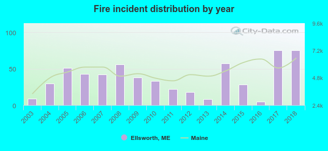 According to the data from the years 2003 - 2018 the average number of fire incidents per year is 37. The highest number of reported fire incidents - 75 took place in 2017, and the least - 5 in 2016. The data has a growing trend.
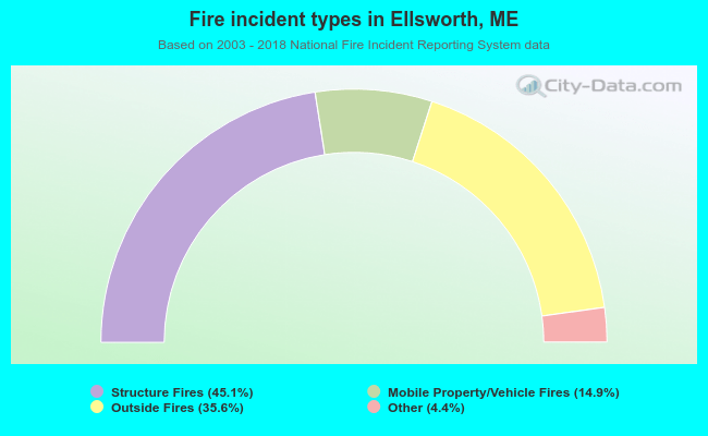 When looking into fire subcategories, the most reports belonged to: Structure Fires (45.1%), and Outside Fires (35.6%).
Fire-safe hotels and motels in Ellsworth, Maine:
- Ramada Ellsworth, 215 High St, Ellsworth, Maine 04605 , Phone: (207) 667-9341, Fax: (207) 667-7294
- Hampton Inn Ellsworth, 6 Downeast Hwy, Ellsworth, Maine 04605 , Phone: (207) 667-2688
- The Eagles Lodge Motel, 278 High St, Ellsworth, Maine 04605 , Phone: (207) 667-3311, Fax: (207) 812-9166
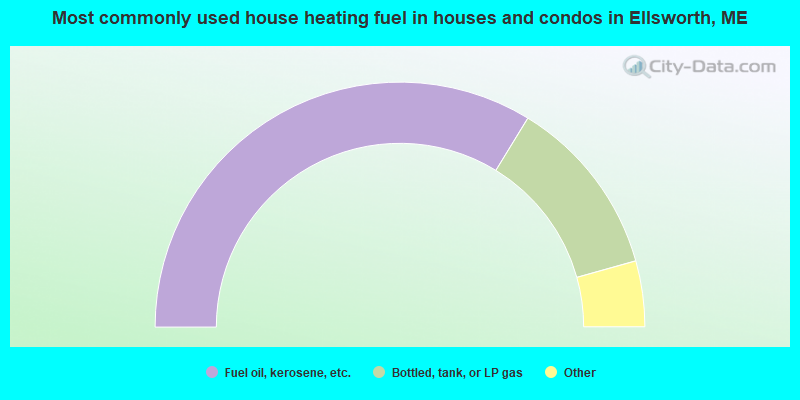
- 67.5%Fuel oil, kerosene, etc.
- 23.8%Bottled, tank, or LP gas
- 3.4%Wood
- 3.1%Electricity
- 1.0%Solar energy
- 0.6%Utility gas
- 0.6%Other fuel
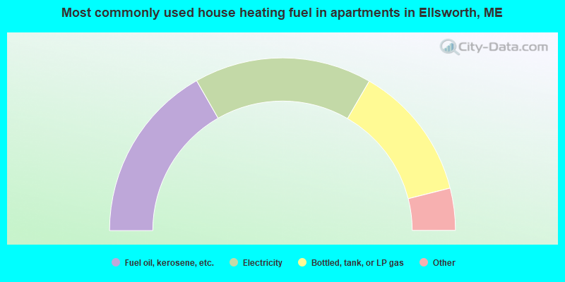
- 33.5%Fuel oil, kerosene, etc.
- 33.3%Electricity
- 25.4%Bottled, tank, or LP gas
- 3.9%Coal or coke
- 2.6%Utility gas
- 1.3%Wood
Ellsworth compared to Maine state average:
- Unemployed percentage significantly below state average.
- Length of stay since moving in significantly below state average.
- Institutionalized population percentage above state average.
Ellsworth on our top lists:
- #12 on the list of "Top 101 cities with the most full-time local library workers per 1000 residents (population 5,000+)"
- #35 on the list of "Top 101 cities with the largest percentage of people in homes for abused, dependent, and neglected children (population 1,000+)"
- #54 on the list of "Top 101 cities with largest percentage of males in industries: information (population 5,000+)"
- #77 on the list of "Top 101 cities with largest percentage of females in industries: health care and social assistance (population 5,000+)"
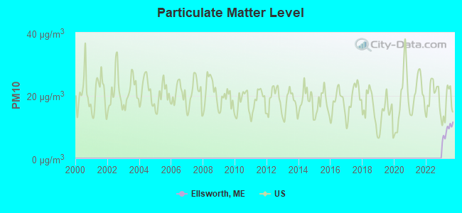
- #3 on the list of "Top 101 counties with the lowest Particulate Matter (PM10) Annual air pollution readings in 2012 (µg/m3)"
- #18 on the list of "Top 101 counties with the lowest Particulate Matter (PM2.5) Annual air pollution readings in 2012 (µg/m3)"
- #30 on the list of "Top 101 counties with the lowest Sulfur Oxides Annual air pollution readings in 2012 (µg/m3)"
- #60 on the list of "Top 101 counties with the highest carbon monoxide air pollution readings in 2012 (ppm)"
- #83 on the list of "Top 101 counties with the lowest total withdrawal of fresh water for public supply (pop. 50,000+)"

|
|
Total of 23 patent applications in 2008-2024.