Hancock, Maine

Submit your own pictures of this town and show them to the world
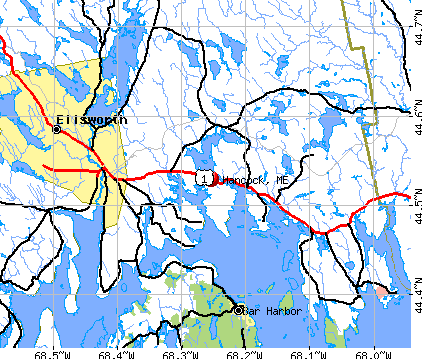
- OSM Map
- General Map
- Google Map
- MSN Map
Population change since 2000: +11.5%
 |
| Males: 1,167 | |
| Females: 1,227 |
| Median resident age: | 44.0 years |
| Maine median age: | 43.0 years |
Zip codes: 04640.
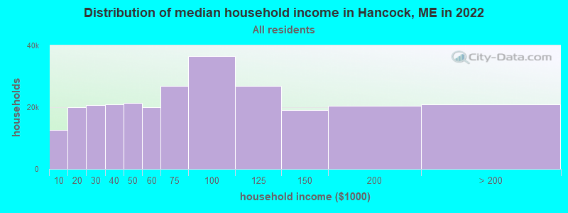
| Hancock: | $59,827 |
| ME: | $69,543 |
Estimated per capita income in 2022: $35,205 (it was $17,339 in 2000)
Hancock town income, earnings, and wages data
Estimated median house or condo value in 2022: $247,151 (it was $86,300 in 2000)
| Hancock: | $247,151 |
| ME: | $290,600 |
Mean prices in 2022: all housing units: $379,336; detached houses: $396,802; townhouses or other attached units: $600,716; in 2-unit structures: $274,479; in 3-to-4-unit structures: $212,346; in 5-or-more-unit structures: $146,369; mobile homes: $158,183; occupied boats, rvs, vans, etc.: $16,454
Detailed information about poverty and poor residents in Hancock, ME


- 2,29195.7%White alone
- 321.3%Two or more races
- 321.3%Hispanic
- 170.7%Asian alone
- 110.5%Black alone
- 90.4%American Indian alone
- 20.08%Other race alone
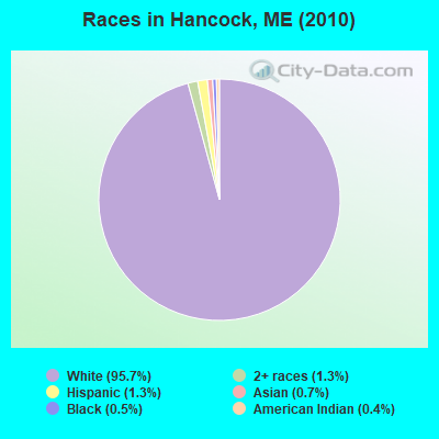
Races in Hancock detailed stats: ancestries, foreign born residents, place of birth
According to our research of Maine and other state lists, there were 6 registered sex offenders living in Hancock, Maine as of July 03, 2024.
The ratio of all residents to sex offenders in Hancock is 399 to 1.
 Recent articles from our blog. Our writers, many of them Ph.D. graduates or candidates, create easy-to-read articles on a wide variety of topics.

 | Maine in the news (27 replies) |
| Maine Covid 19 Thread (376 replies) |
| Looking at Maine (41 replies) |
| Maine Demographics (36 replies) |
| One more Moving to Maine thread (27 replies) |
| Maine weather thread (3207 replies) |
Latest news from Hancock, ME collected exclusively by city-data.com from local newspapers, TV, and radio stations
Hancock, ME City Guides:
Ancestries: English (23.1%), Irish (18.6%), United States (11.8%), German (8.4%), French (6.4%), Scottish (5.5%).
Current Local Time: EST time zone
Incorporated on 02/21/1828
Elevation: 30 feet
Land area: 29.8 square miles.
Population density: 80 people per square mile (very low).
57 residents are foreign born (1.2% Europe, 0.6% North America, 0.5% Asia).
| This town: | 2.7% |
| Maine: | 2.9% |
| Hancock town: | 1.1% ($937) |
| Maine: | 1.5% ($1,417) |
Nearest city with pop. 50,000+: Portland, ME  (115.2 miles , pop. 64,249).
Nearest city with pop. 200,000+: Boston, MA (207.6 miles , pop. 589,141).
Nearest city with pop. 1,000,000+: Bronx, NY (381.3 miles , pop. 1,332,650).
Nearest cities:
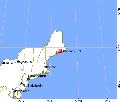
), Latitude: 44.52 N, Longitude: 68.28 W
Area code commonly used in this area: 207

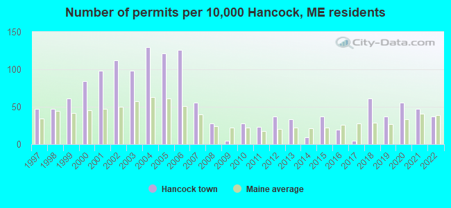
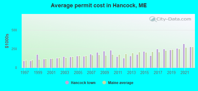
Single-family new house construction building permits:
- 2022: 8 buildings, average cost: $276,700
- 2021: 10 buildings, average cost: $317,400
- 2020: 12 buildings, average cost: $256,700
- 2019: 8 buildings, average cost: $239,200
- 2018: 13 buildings, average cost: $251,000
- 2017: 1 building, cost: $250,000
- 2016: 4 buildings, average cost: $160,700
- 2015: 8 buildings, average cost: $218,800
- 2014: 2 buildings, average cost: $178,500
- 2013: 7 buildings, average cost: $155,800
- 2012: 8 buildings, average cost: $127,500
- 2011: 5 buildings, average cost: $148,600
- 2010: 6 buildings, average cost: $234,500
- 2009: 1 building, cost: $220,000
- 2008: 6 buildings, average cost: $206,700
- 2007: 12 buildings, average cost: $182,600
- 2006: 27 buildings, average cost: $153,800
- 2005: 26 buildings, average cost: $156,100
- 2004: 28 buildings, average cost: $145,800
- 2003: 21 buildings, average cost: $147,800
- 2002: 24 buildings, average cost: $129,500
- 2001: 21 buildings, average cost: $121,200
- 2000: 18 buildings, average cost: $118,000
- 1999: 13 buildings, average cost: $179,100
- 1998: 10 buildings, average cost: $91,600
- 1997: 10 buildings, average cost: $91,700
| Here: | 4.3% |
| Maine: | 3.4% |
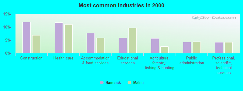
- Construction (12.0%)
- Health care (11.7%)
- Accommodation & food services (7.7%)
- Educational services (5.9%)
- Agriculture, forestry, fishing & hunting (5.7%)
- Public administration (4.3%)
- Professional, scientific, technical services (4.1%)
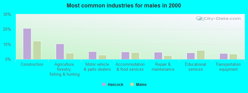
- Construction (20.7%)
- Agriculture, forestry, fishing & hunting (10.3%)
- Motor vehicle & parts dealers (5.1%)
- Accommodation & food services (4.9%)
- Repair & maintenance (4.7%)
- Educational services (4.4%)
- Transportation equipment (4.0%)
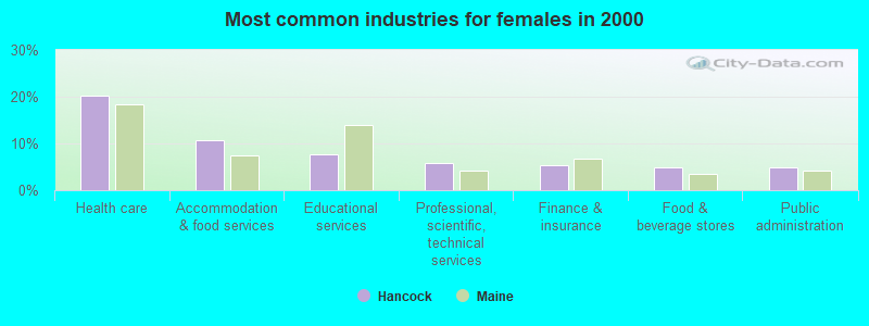
- Health care (20.3%)
- Accommodation & food services (10.7%)
- Educational services (7.6%)
- Professional, scientific, technical services (5.8%)
- Finance & insurance (5.5%)
- Food & beverage stores (4.9%)
- Public administration (4.9%)
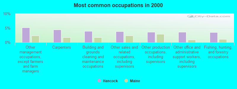
- Other management occupations, except farmers and farm managers (5.2%)
- Carpenters (4.4%)
- Building and grounds cleaning and maintenance occupations (3.9%)
- Other sales and related occupations, including supervisors (3.9%)
- Other production occupations, including supervisors (3.6%)
- Other office and administrative support workers, including supervisors (3.6%)
- Fishing, hunting, and forestry occupations (3.5%)
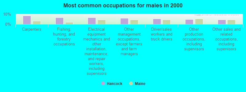
- Carpenters (8.5%)
- Fishing, hunting, and forestry occupations (6.7%)
- Electrical equipment mechanics and other installation, maintenance, and repair workers, including supervisors (6.5%)
- Other management occupations, except farmers and farm managers (6.0%)
- Driver/sales workers and truck drivers (5.4%)
- Other production occupations, including supervisors (4.9%)
- Other sales and related occupations, including supervisors (4.5%)

- Other office and administrative support workers, including supervisors (5.7%)
- Preschool, kindergarten, elementary, and middle school teachers (5.5%)
- Secretaries and administrative assistants (4.7%)
- Nursing, psychiatric, and home health aides (4.5%)
- Registered nurses (4.5%)
- Other management occupations, except farmers and farm managers (4.3%)
- Building and grounds cleaning and maintenance occupations (4.1%)
Average climate in Hancock, Maine
Based on data reported by over 4,000 weather stations


(lower is better)
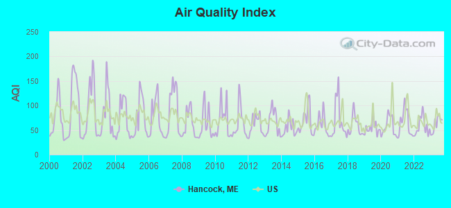
Air Quality Index (AQI) level in 2023 was 61.9. This is about average.
| City: | 61.9 |
| U.S.: | 72.6 |
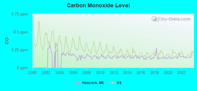
Carbon Monoxide (CO) [ppm] level in 2023 was 0.172. This is significantly better than average. Closest monitor was 10.3 miles away from the city center.
| City: | 0.172 |
| U.S.: | 0.251 |
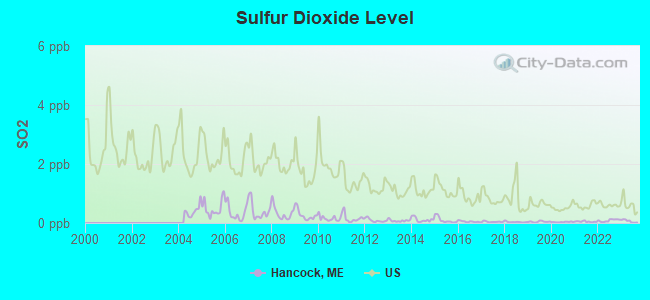
Sulfur Dioxide (SO2) [ppb] level in 2023 was 0.0636. This is significantly better than average. Closest monitor was 10.3 miles away from the city center.
| City: | 0.0636 |
| U.S.: | 1.5147 |
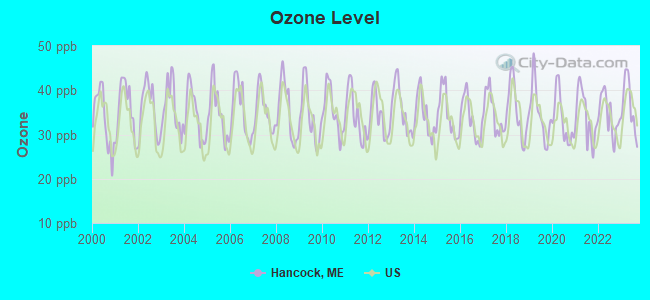
Ozone [ppb] level in 2023 was 36.6. This is about average. Closest monitor was 10.3 miles away from the city center.
| City: | 36.6 |
| U.S.: | 33.3 |
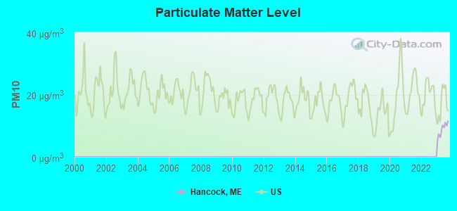
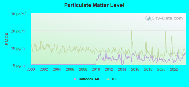
Particulate Matter (PM2.5) [µg/m3] level in 2023 was 4.90. This is significantly better than average. Closest monitor was 10.3 miles away from the city center.
| City: | 4.90 |
| U.S.: | 8.11 |
Earthquake activity:
Hancock-area historical earthquake activity is significantly above Maine state average. It is 81% smaller than the overall U.S. average.On 10/16/2012 at 23:12:25, a magnitude 4.7 (4.7 ML, Depth: 10.0 mi, Class: Light, Intensity: IV - V) earthquake occurred 134.2 miles away from the city center
On 4/20/2002 at 10:50:47, a magnitude 5.3 (5.3 ML, Depth: 3.0 mi, Class: Moderate, Intensity: VI - VII) earthquake occurred 267.0 miles away from the city center
On 4/20/2002 at 10:50:47, a magnitude 5.2 (5.2 MB, 4.2 MS, 5.2 MW, 5.0 MW) earthquake occurred 268.1 miles away from the city center
On 1/19/1982 at 00:14:42, a magnitude 4.7 (4.5 MB, 4.7 MD, 4.5 LG) earthquake occurred 179.6 miles away from the city center
On 10/7/1983 at 10:18:46, a magnitude 5.3 (5.1 MB, 5.3 LG, 5.1 ML) earthquake occurred 302.8 miles away from Hancock center
On 10/3/2006 at 00:07:38, a magnitude 3.7 (3.7 MD, Depth: 6.2 mi, Class: Light, Intensity: II - III) earthquake occurred 12.8 miles away from Hancock center
Magnitude types: regional Lg-wave magnitude (LG), body-wave magnitude (MB), duration magnitude (MD), local magnitude (ML), surface-wave magnitude (MS), moment magnitude (MW)
Natural disasters:
The number of natural disasters in Hancock County (18) is near the US average (15).Major Disasters (Presidential) Declared: 11
Emergencies Declared: 6
Causes of natural disasters: Floods: 9, Storms: 8, Snows: 5, Blizzard: 1, Heavy Rain: 1, Hurricane: 1, Ice Storm: 1, Landslide: 1, Snowfall: 1, Wind: 1, Winter Storm: 1, Other: 2 (Note: some incidents may be assigned to more than one category).

Hospitals and medical centers near Hancock:
- BIRCHWOOD LIVING CENTER (Hospital, about 7 miles away; ELLSWORTH, ME)
- COLLIER'S REHAB AND NURSING CTR (Nursing Home, about 8 miles away; ELLSWORTH, ME)
- COURTLAND REHAB AND LIVING CENTER (Nursing Home, about 8 miles away; ELLSWORTH, ME)
- SONOGEE ESTATES (Nursing Home, about 9 miles away; BAR HARBOR, ME)
- SONOGEE REHABILITATION AND LIVING CENTER (Nursing Home, about 9 miles away; BAR HARBOR, ME)
- MOUNT DESERT ISLAND HOSPITAL Critical Access Hospitals (about 11 miles away; BAR HARBOR, ME)
Colleges/universities with over 2000 students nearest to Hancock:
- University of Maine (about 33 miles; Orono, ME; Full-time enrollment: 8,931)
- Husson University (about 33 miles; Bangor, ME; FT enrollment: 2,421)
- University of Maine at Augusta (about 76 miles; Augusta, ME; FT enrollment: 3,204)
- University of Maine at Farmington (about 93 miles; Farmington, ME; FT enrollment: 2,036)
- Southern Maine Community College (about 115 miles; South Portland, ME; FT enrollment: 4,666)
- University of Southern Maine (about 116 miles; Portland, ME; FT enrollment: 6,647)
- Saint Joseph's College of Maine (about 120 miles; Standish, ME; FT enrollment: 2,010)
Public elementary/middle school in Hancock:
- HANCOCK GRAMMAR SCHOOL (Location: NO PHYSICAL LOCATION AVAILABLE, Grades: KG-8)
Points of interest:
Notable locations in Hancock: White Birches Golf Course (A), Hancock Volunteer Fire Department Station 1 (B), Hancock Volunteer Fire Department Station 2 (C). Display/hide their locations on the map
Church in Hancock: Church of Christ (A). Display/hide its location on the map
Cemeteries: McFarland Hill Cemetery (1), Riverside Cemetery (2), Hillcrest Cemetery (3). Display/hide their locations on the map
Lakes: Old Pond (A), Simmons Pond (B). Display/hide their locations on the map
Streams, rivers, and creeks: Kilkenny Stream (A), Egypt Stream (B). Display/hide their locations on the map
Tourist attraction: Hancock Point Kayak Tours (Ski & Helicopter Tours; 58 Point Rd.) (1). Display/hide its approximate location on the map
Hotel: Three Pines Bed and Breakfast (274 East Side Road) (1). Display/hide its approximate location on the map
Drinking water stations with addresses in Hancock and their reported violations in the past:
LE DOMAINE RESTAURANT (Population served: 190, Groundwater):Past monitoring violations:CROCKER HOUSE COUNTRY INN INC (Population served: 157, Groundwater):
- 7 routine major monitoring violations
Past monitoring violations:CHIPPERS RESTAURANT DELI (Population served: 126, Groundwater):
- 8 routine major monitoring violations
- 6 regular monitoring violations
Past monitoring violations:SALT BOX (Population served: 103, Groundwater):
- Monitoring, Check/Repeat/Confirmation - In OCT-2005, Contaminant: Nitrate. Follow-up actions: St Public Notif requested (JAN-23-2006), St Violation/Reminder Notice (JAN-23-2006), St Public Notif received (JUN-07-2006), St Compliance achieved (JAN-29-2007), St BCA signed (MAR-29-2007)
- 18 routine major monitoring violations
- 23 regular monitoring violations
Past health violations:RUTH & WIMPYS RESTAURANT INC (Population served: 96, Groundwater):Past monitoring violations:
- MCL, Monthly (TCR) - In MAR-2010, Contaminant: Coliform. Follow-up actions: St AO (w/o penalty) issued (SEP-29-2008), St Admin Penalty assessed (MAR-25-2009), St Public Notif requested (APR-05-2010), St Formal NOV issued (APR-05-2010), St Intentional no-action (APR-04-2011), St Other (APR-14-2011), St Compliance achieved (AUG-26-2011)
- MCL, Monthly (TCR) - In FEB-2010, Contaminant: Coliform. Follow-up actions: St AO (w/o penalty) issued (SEP-29-2008), St Admin Penalty assessed (MAR-25-2009), St Public Notif requested (MAR-01-2010), St Formal NOV issued (MAR-01-2010), St Intentional no-action (APR-04-2011), St Other (APR-14-2011), St Compliance achieved (AUG-26-2011)
- MCL, Monthly (TCR) - In JAN-2010, Contaminant: Coliform. Follow-up actions: St AO (w/o penalty) issued (SEP-29-2008), St Admin Penalty assessed (MAR-25-2009), St Public Notif requested (JAN-13-2010), St Formal NOV issued (JAN-13-2010), St Public Notif received (JAN-27-2010), St Other (APR-14-2011), St Compliance achieved (AUG-26-2011)
- MCL, Monthly (TCR) - In DEC-2009, Contaminant: Coliform. Follow-up actions: St AO (w/o penalty) issued (SEP-29-2008), St Admin Penalty assessed (MAR-25-2009), St Public Notif requested (DEC-31-2009), St Formal NOV issued (DEC-31-2009), St Public Notif received (JAN-14-2010), St Other (APR-14-2011), St Compliance achieved (AUG-26-2011)
- MCL, Monthly (TCR) - In FEB-2007, Contaminant: Coliform. Follow-up actions: St Public Notif requested (MAR-09-2007), St Violation/Reminder Notice (MAR-09-2007), St Public Notif received (2 times from MAR-26-2007 to MAR-26-2007), St Compliance achieved (AUG-26-2011)
- 39 routine major monitoring violations
- One minor monitoring violation
- 13 regular monitoring violations
Past monitoring violations:
- 18 routine major monitoring violations
- 7 regular monitoring violations
| This town: | 2.3 people |
| Maine: | 2.3 people |
| This town: | 64.2% |
| Whole state: | 62.9% |
| This town: | 11.8% |
| Whole state: | 9.4% |
Likely homosexual households (counted as self-reported same-sex unmarried-partner households)
- Lesbian couples: 0.7% of all households
- Gay men: 0.5% of all households
| This town: | 9.9% |
| Whole state: | 10.9% |
| This town: | 2.9% |
| Whole state: | 4.1% |
7 people in other noninstitutional group quarters in 2000
For population 15 years and over in Hancock:
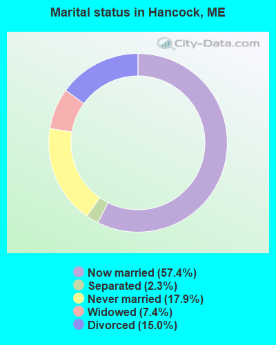
- Never married: 17.9%
- Now married: 57.4%
- Separated: 2.3%
- Widowed: 7.4%
- Divorced: 15.0%
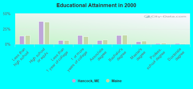
For population 25 years and over in Hancock:
- High school or higher: 86.6%
- Bachelor's degree or higher: 21.8%
- Graduate or professional degree: 7.4%
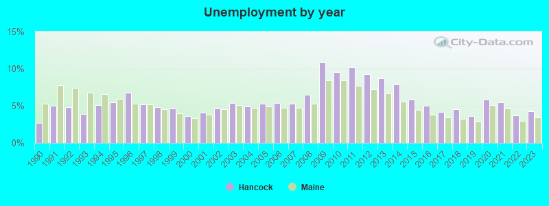
- Unemployed: 5.8%
- Mean travel time to work (commute): 22.0 minutes
| Here: | 10.2 |
| Maine average: | 11.2 |


Graphs represent county-level data. Detailed 2008 Election Results
Religion statistics for Hancock, ME (based on Hancock County data)


| Religion | Adherents | Congregations |
|---|---|---|
| Mainline Protestant | 4,691 | 58 |
| Catholic | 2,523 | 9 |
| Evangelical Protestant | 1,288 | 23 |
| Other | 820 | 11 |
| None | 45,096 | - |
Food Environment Statistics:
| This county: | 6.01 / 10,000 pop. |
| State: | 2.80 / 10,000 pop. |
| Hancock County: | 1.69 / 10,000 pop. |
| Maine: | 2.20 / 10,000 pop. |
| This county: | 4.89 / 10,000 pop. |
| State: | 5.75 / 10,000 pop. |
| Hancock County: | 21.61 / 10,000 pop. |
| State: | 11.02 / 10,000 pop. |
| This county: | 7.4% |
| State: | 8.2% |
| Hancock County: | 25.4% |
| Maine: | 25.0% |
Businesses in Hancock, ME
- Knights Inn: 1
- MasterBrand Cabinets: 3
Strongest AM radio stations in Hancock:
- WDEA (1370 AM; 5 kW; ELLSWORTH, ME; Owner: CUMULUS LICENSING CORP.)
- WZON (620 AM; 5 kW; BANGOR, ME; Owner: THE ZONE CORPORATION)
- WABI (910 AM; 5 kW; BANGOR, ME; Owner: CLEAR CHANNEL BROADCASTING LICENSES, INC.)
- WSKW (1160 AM; 10 kW; SKOWHEGAN, ME; Owner: MOUNTAIN WIRELESS, INCORPORATED)
- WRKO (680 AM; 50 kW; BOSTON, MA; Owner: ENTERCOM BOSTON LICENSE, LLC)
- WEEI (850 AM; 50 kW; BOSTON, MA; Owner: ENTERCOM BOSTON LICENSE, LLC)
- WBZ (1030 AM; 50 kW; BOSTON, MA; Owner: INFINITY BROADCASTING OPERATIONS, INC.)
- WTME (780 AM; 10 kW; RUMFORD, ME; Owner: MOUNTAIN VALLEY BROADCASTING, INC.)
- WCRN (830 AM; 50 kW; WORCESTER, MA; Owner: CARTER BROADCASTING CORPORATION)
- WNNZ (640 AM; 50 kW; WESTFIELD, MA; Owner: CLEAR CHANNEL BROADCASTING LICENSES, INC.)
- WKOX (1200 AM; 50 kW; FRAMINGHAM, MA; Owner: CAPSTAR TX LIMITED PARTNERSHIP)
- WNZS (1340 AM; 1 kW; VEAZIE, ME; Owner: WATERFRONT COMMUNICATIONS INC.)
- WALE (990 AM; 50 kW; GREENVILLE, RI; Owner: NORTH AMERICAN BROADCASTING CO., INC.)
Strongest FM radio stations in Hancock:
- WLKE (99.1 FM; BAR HARBOR, ME; Owner: CLEAR CHANNEL BROADCASTING LICENSES, INC.)
- WNSX (97.7 FM; WINTER HARBOR, ME; Owner: CLEAR CHANNEL BROADCASTING LICENSES, INC.)
- WBQI (107.7 FM; BAR HARBOR, ME; Owner: MARINER BROADCASTING, L.P.)
- WERU-FM (89.9 FM; BLUE HILL, ME; Owner: SALT POND COMMUNITY B/C COMPANY)
- WWMJ (95.7 FM; ELLSWORTH, ME; Owner: CUMULUS LICENSING CORP.)
- WMEH (90.9 FM; BANGOR, ME; Owner: MAINE PUBLIC BROADCASTING CORPORATION)
- WEZQ (92.9 FM; BANGOR, ME; Owner: CUMULUS LICENSING CORP.)
- WKIT-FM (100.3 FM; BREWER, ME; Owner: THE ZONE CORPORATION)
- WBFB (104.7 FM; BELFAST, ME; Owner: CLEAR CHANNEL BROADCASTING LICENSES, INC.)
- WHCF (88.5 FM; BANGOR, ME; Owner: BANGOR BAPTIST CHURCH)
- WFZX (101.7 FM; SEARSPORT, ME; Owner: CLEAR CHANNEL BROADCASTING LICENSES, INC.)
- WVOM (103.9 FM; HOWLAND, ME; Owner: CLEAR CHANNEL BROADCASTING LICENSES, INC.)
- WWBX (97.1 FM; BANGOR, ME; Owner: CLEAR CHANNEL BROADCASTING LICENSES, INC.)
- WMEP (90.5 FM; CAMDEN, ME; Owner: MAINE PUBLIC BROADCASTING CORP.)
- WQSS (102.5 FM; CAMDEN, ME; Owner: CLEAR CHANNEL BROADCASTING LICENSES, INC.)
TV broadcast stations around Hancock:
- WMEB-TV (Channel 12; ORONO, ME; Owner: MAINE PUBLIC BROADCASTING CORPORATION)
- WCKD-LP (Channel 30; BANGOR/DEDHAM, ME; Owner: J. MCLEOD, ME FAMILY B/CING., INC.)
- W66CL (Channel 66; BANGOR, ME; Owner: MS COMMUNICATIONS, LLC)
- National Bridge Inventory (NBI) Statistics
- 3Number of bridges
- 112ft / 33.6mTotal length
- 29,404Total average daily traffic
- 1,470Total average daily truck traffic
- 41,166Total future (year 2036) average daily traffic
FCC Registered Amateur Radio Licenses: 38 (See the full list of FCC Registered Amateur Radio Licenses in Hancock)
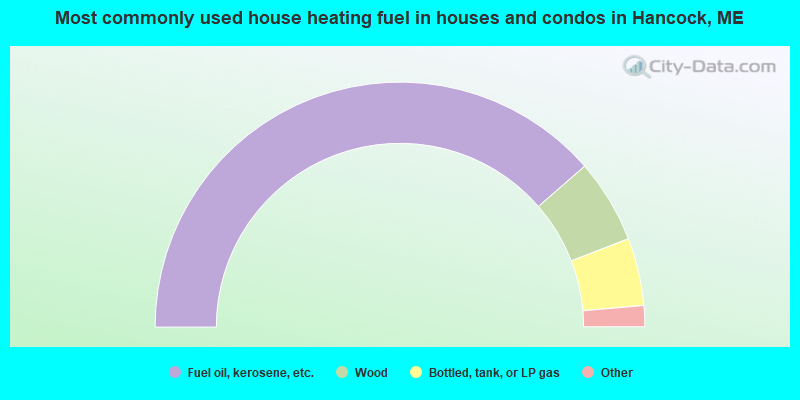
- 77.2%Fuel oil, kerosene, etc.
- 11.1%Wood
- 8.9%Bottled, tank, or LP gas
- 2.5%Electricity
- 0.3%Coal or coke
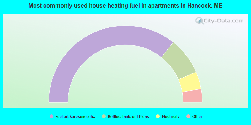
- 71.3%Fuel oil, kerosene, etc.
- 15.7%Bottled, tank, or LP gas
- 7.3%Electricity
- 3.9%Wood
- 1.7%No fuel used
Hancock compared to Maine state average:
- Unemployed percentage below state average.
- Black race population percentage significantly below state average.
- Length of stay since moving in significantly above state average.
- Number of rooms per house significantly below state average.
- House age significantly below state average.

|
Total of 6 patent applications in 2008-2024.