Orland, Maine


Submit your own pictures of this town and show them to the world
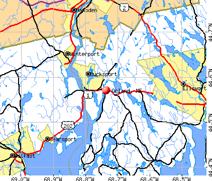
- OSM Map
- General Map
- Google Map
- MSN Map
Population change since 2000: +4.3%
 |
| Males: 1,112 | |
| Females: 1,113 |
| Median resident age: | 47.3 years |
| Maine median age: | 43.0 years |
Zip codes: 04472.
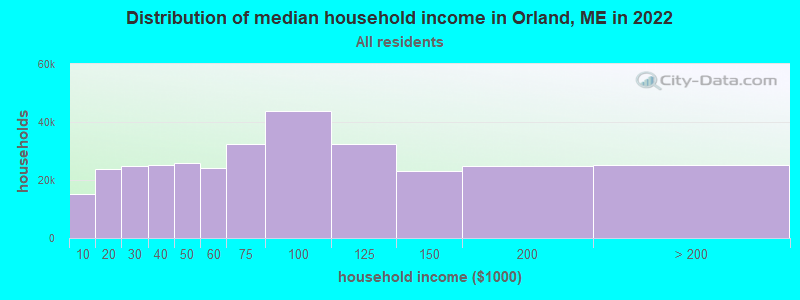
| Orland: | $71,814 |
| ME: | $69,543 |
Estimated per capita income in 2022: $39,697 (it was $19,551 in 2000)
Orland town income, earnings, and wages data
Estimated median house or condo value in 2022: $252,879 (it was $88,300 in 2000)
| Orland: | $252,879 |
| ME: | $290,600 |
Mean prices in 2022: all housing units: $379,336; detached houses: $396,802; townhouses or other attached units: $600,716; in 2-unit structures: $274,479; in 3-to-4-unit structures: $212,346; in 5-or-more-unit structures: $146,369; mobile homes: $158,183; occupied boats, rvs, vans, etc.: $16,454
Detailed information about poverty and poor residents in Orland, ME


- 2,15696.9%White alone
- 261.2%Hispanic
- 251.1%Two or more races
- 70.3%Asian alone
- 50.2%American Indian alone
- 50.2%Other race alone
- 10.04%Black alone
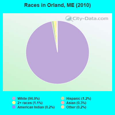
Races in Orland detailed stats: ancestries, foreign born residents, place of birth
According to our research of Maine and other state lists, there were 3 registered sex offenders living in Orland, Maine as of May 08, 2024.
The ratio of all residents to sex offenders in Orland is 742 to 1.
The ratio of registered sex offenders to all residents in this city is lower than the state average.
 Recent articles from our blog. Our writers, many of them Ph.D. graduates or candidates, create easy-to-read articles on a wide variety of topics.

 | Great house in Orland (3 replies) |
| Maine weather thread (3207 replies) |
| Considering moving to Maine (10 replies) |
| Secondhand winter gear, coats/ boots etc? (near Blue Hill) (19 replies) |
| Coastal towns - what am I missing? (15 replies) |
| Maine Summer Camps - Sleepaway camps (13 replies) |
Latest news from Orland, ME collected exclusively by city-data.com from local newspapers, TV, and radio stations
Ancestries: United States (22.8%), English (21.0%), Irish (12.2%), French (9.4%), German (6.8%), Scottish (5.7%).
Current Local Time: EST time zone
Incorporated on 02/21/1800
Elevation: 220 feet
Land area: 46.9 square miles.
Population density: 47 people per square mile (very low).
20 residents are foreign born
| This town: | 0.9% |
| Maine: | 2.9% |
| Orland town: | 1.2% ($1,034) |
| Maine: | 1.5% ($1,417) |
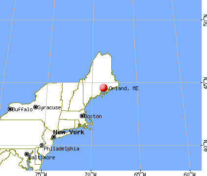
Nearest city with pop. 50,000+: Portland, ME  (100.6 miles , pop. 64,249).
Nearest city with pop. 200,000+: Boston, MA (197.0 miles , pop. 589,141).
Nearest city with pop. 1,000,000+: Bronx, NY (368.6 miles , pop. 1,332,650).
Nearest cities:
), ), ), ), ), Latitude: 44.57 N, Longitude: 68.69 W
Area code commonly used in this area: 207

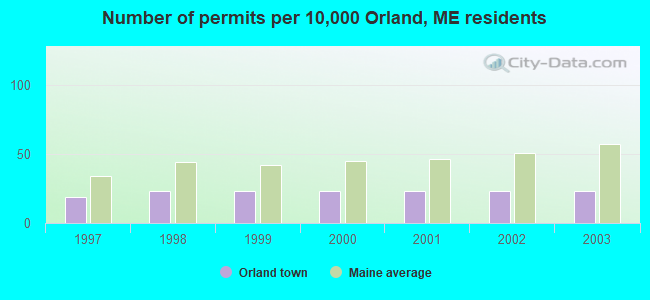
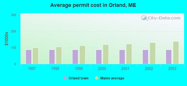
Single-family new house construction building permits:
- 2003: 5 buildings, average cost: $87,400
- 2002: 5 buildings, average cost: $87,400
- 2001: 5 buildings, average cost: $87,400
- 2000: 5 buildings, average cost: $87,400
- 1999: 5 buildings, average cost: $87,400
- 1998: 5 buildings, average cost: $87,400
- 1997: 4 buildings, average cost: $87,400
| Here: | 3.0% |
| Maine: | 3.4% |

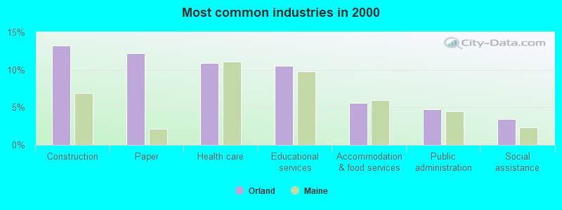
- Construction (13.2%)
- Paper (12.2%)
- Health care (10.9%)
- Educational services (10.6%)
- Accommodation & food services (5.6%)
- Public administration (4.8%)
- Social assistance (3.5%)

- Construction (21.8%)
- Paper (20.9%)
- Educational services (6.2%)
- Public administration (4.4%)
- Health care (3.4%)
- Accommodation & food services (3.2%)
- Agriculture, forestry, fishing & hunting (3.0%)

- Health care (19.9%)
- Educational services (15.8%)
- Accommodation & food services (8.6%)
- Social assistance (6.0%)
- Public administration (5.1%)
- Professional, scientific, technical services (4.1%)
- Finance & insurance (3.9%)

- Other production occupations, including supervisors (7.7%)
- Preschool, kindergarten, elementary, and middle school teachers (5.7%)
- Carpenters (5.4%)
- Other sales and related occupations, including supervisors (4.4%)
- Other management occupations, except farmers and farm managers (3.4%)
- Retail sales workers, except cashiers (3.0%)
- Secretaries and administrative assistants (2.8%)

- Other production occupations, including supervisors (11.7%)
- Carpenters (9.9%)
- Other sales and related occupations, including supervisors (4.6%)
- Electrical equipment mechanics and other installation, maintenance, and repair workers, including supervisors (4.1%)
- Other management occupations, except farmers and farm managers (3.7%)
- Driver/sales workers and truck drivers (3.7%)
- Vehicle and mobile equipment mechanics, installers, and repairers (3.7%)

- Preschool, kindergarten, elementary, and middle school teachers (9.9%)
- Secretaries and administrative assistants (6.2%)
- Other office and administrative support workers, including supervisors (5.4%)
- Health technologists and technicians (4.9%)
- Other sales and related occupations, including supervisors (4.1%)
- Waiters and waitresses (3.6%)
- Cashiers (3.6%)
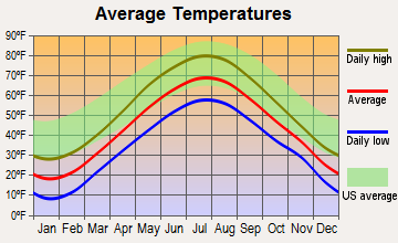
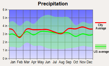
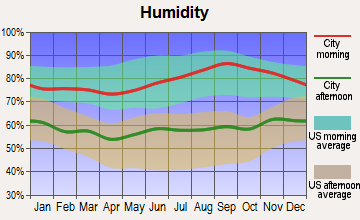
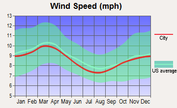
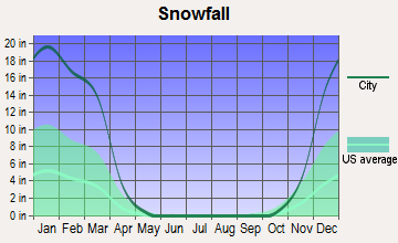
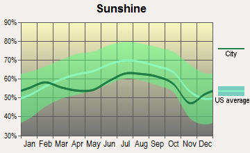
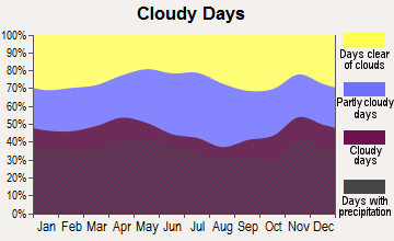
Average climate in Orland, Maine
Based on data reported by over 4,000 weather stations
(lower is better)
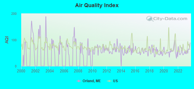
Air Quality Index (AQI) level in 2023 was 61.1. This is about average.
| City: | 61.1 |
| U.S.: | 72.6 |
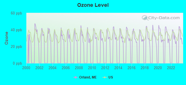
Ozone [ppb] level in 2023 was 33.6. This is about average. Closest monitor was 6.4 miles away from the city center.
| City: | 33.6 |
| U.S.: | 33.3 |
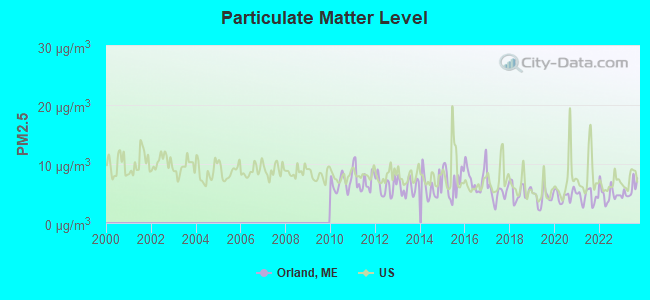
Particulate Matter (PM2.5) [µg/m3] level in 2023 was 5.62. This is significantly better than average. Closest monitor was 16.1 miles away from the city center.
| City: | 5.62 |
| U.S.: | 8.11 |
Earthquake activity:
Orland-area historical earthquake activity is significantly above Maine state average. It is 80% smaller than the overall U.S. average.On 10/16/2012 at 23:12:25, a magnitude 4.7 (4.7 ML, Depth: 10.0 mi, Class: Light, Intensity: IV - V) earthquake occurred 118.9 miles away from Orland center
On 4/20/2002 at 10:50:47, a magnitude 5.3 (5.3 ML, Depth: 3.0 mi, Class: Moderate, Intensity: VI - VII) earthquake occurred 247.0 miles away from Orland center
On 4/20/2002 at 10:50:47, a magnitude 5.2 (5.2 MB, 4.2 MS, 5.2 MW, 5.0 MW) earthquake occurred 248.1 miles away from the city center
On 1/19/1982 at 00:14:42, a magnitude 4.7 (4.5 MB, 4.7 MD, 4.5 LG) earthquake occurred 162.8 miles away from Orland center
On 10/7/1983 at 10:18:46, a magnitude 5.3 (5.1 MB, 5.3 LG, 5.1 ML) earthquake occurred 283.4 miles away from Orland center
On 2/26/1999 at 03:38:43, a magnitude 3.8 (3.8 LG, Depth: 2.0 mi, Class: Light, Intensity: II - III) earthquake occurred 41.6 miles away from Orland center
Magnitude types: regional Lg-wave magnitude (LG), body-wave magnitude (MB), duration magnitude (MD), local magnitude (ML), surface-wave magnitude (MS), moment magnitude (MW)
Natural disasters:
The number of natural disasters in Hancock County (18) is near the US average (15).Major Disasters (Presidential) Declared: 11
Emergencies Declared: 6
Causes of natural disasters: Floods: 9, Storms: 8, Snows: 5, Blizzard: 1, Heavy Rain: 1, Hurricane: 1, Ice Storm: 1, Landslide: 1, Snowfall: 1, Wind: 1, Winter Storm: 1, Other: 2 (Note: some incidents may be assigned to more than one category).
Hospitals and medical centers near Orland:
- COURTLAND REHAB AND LIVING CENTER (Nursing Home, about 13 miles away; ELLSWORTH, ME)
- COLLIER'S REHAB AND NURSING CTR (Nursing Home, about 14 miles away; ELLSWORTH, ME)
- BIRCHWOOD LIVING CENTER (Hospital, about 14 miles away; ELLSWORTH, ME)
- KINDRED TRANSITIONAL CARE AND REHAB-BREWER (Nursing Home, about 15 miles away; BREWER, ME)
Colleges/universities with over 2000 students nearest to Orland:
- Husson University (about 19 miles; Bangor, ME; Full-time enrollment: 2,421)
- University of Maine (about 23 miles; Orono, ME; FT enrollment: 8,931)
- University of Maine at Augusta (about 58 miles; Augusta, ME; FT enrollment: 3,204)
- University of Maine at Farmington (about 73 miles; Farmington, ME; FT enrollment: 2,036)
- Southern Maine Community College (about 100 miles; South Portland, ME; FT enrollment: 4,666)
- University of Southern Maine (about 102 miles; Portland, ME; FT enrollment: 6,647)
- Saint Joseph's College of Maine (about 104 miles; Standish, ME; FT enrollment: 2,010)
Points of interest:
Notable locations in Orland: Whispering Pines Campground (A), Shady Oaks Campground (B), Balsam Cove Campground (C), Craig Brook National Fish Hatchery (D), Orland Volunteer Fire Department (E). Display/hide their locations on the map
Cemeteries: Back Ridge Cemetery (1), Evergreen Cemetery (2), Gross Point Cemetery (3), Leaches Point Cemetery (4), Granite Cemetery (5), Front Ridge Cemetery (6), Oak Grove Cemetery (7). Display/hide their locations on the map
Lakes, reservoirs, and swamps: Heart Pond (A), Hothole Pond (B), Little Pond (C), Rocky Pond (D), Main Stem Orland River Reservoir (E), Alamoosook Lake (F), Craig Pond (G), Hell Bottom Swamp (H). Display/hide their locations on the map
Streams, rivers, and creeks: Gold Brook (A), Atkinson Brook (B), Craig Pond Brook (C), Carlisle Brook (D), Rocky Pond Brook (E), Thompson Brook (F), Bowden Hill Brook (G), Meadow Brook (H), Dead River (I). Display/hide their locations on the map
Hotel: Alamoosook Lodge (Alamoosook Lake) (1). Display/hide its approximate location on the map
Birthplace of: Walter Van Tilburg Clark - Novelist.
Drinking water stations with addresses in Orland and their reported violations in the past:
ALAMOOSOOK LODGE (Address: 229 SOPER ROAD , Population served: 112, Groundwater):Past health violations:HOME INC & LEARNING CENTER (Population served: 55, Groundwater):
- MCL, Monthly (TCR) - In SEP-2009, Contaminant: Coliform. Follow-up actions: St Formal NOV issued (OCT-07-2009), St Public Notif requested (OCT-07-2009), St Public Notif received (OCT-28-2009), St Compliance achieved (NOV-24-2009)
- MCL, Monthly (TCR) - In AUG-2009, Contaminant: Coliform. Follow-up actions: St Formal NOV issued (SEP-10-2009), St Public Notif requested (SEP-10-2009), St Public Notif received (SEP-21-2009), St Compliance achieved (SEP-07-2011)
- MCL, Monthly (TCR) - In JUL-2009, Contaminant: Coliform. Follow-up actions: St Formal NOV issued (JUL-30-2009), St Public Notif requested (JUL-30-2009), St Public Notif received (AUG-19-2009), St Compliance achieved (OCT-28-2009)
Past monitoring violations:DEER RIDGE MOBILE HOME PARK (Population served: 33, Groundwater):
- Follow-up Or Routine LCR Tap M/R - In JAN-01-2009, Contaminant: Lead and Copper Rule. Follow-up actions: St Public Notif requested (DEC-09-2008), St Formal NOV issued (DEC-09-2008), St AO (w/o penalty) issued (MAR-31-2009), St Public Notif received (APR-28-2009), St Compliance achieved (MAY-04-2009)
- Follow-up Or Routine LCR Tap M/R - In JAN-01-2008, Contaminant: Lead and Copper Rule. Follow-up actions: St Public Notif requested (JAN-25-2008), St Formal NOV issued (JAN-25-2008), St AO (w/o penalty) issued (MAY-12-2008), St Public Notif received (MAY-22-2008), St Compliance achieved (AUG-29-2011)
- Monitoring and Reporting (DBP) - Between JAN-2005 and DEC-2007, Contaminant: TTHM. Follow-up actions: St Public Notif requested (APR-17-2008), St Formal NOV issued (APR-17-2008), St AO (w/o penalty) issued (MAY-12-2008), St Public Notif received (MAY-22-2008), St Compliance achieved (MAR-24-2009)
- Monitoring and Reporting (DBP) - Between JAN-2005 and DEC-2007, Contaminant: Total Haloacetic Acids (HAA5). Follow-up actions: St Public Notif requested (APR-17-2008), St Formal NOV issued (APR-17-2008), St AO (w/o penalty) issued (MAY-12-2008), St Public Notif received (MAY-22-2008), St Compliance achieved (MAR-24-2009)
- 24 routine major monitoring violations
- 58 regular monitoring violations
Past monitoring violations:HOME MARKET STAND/ SOUP KITCHEN (Population served: 25, Groundwater):
- 2 routine major monitoring violations
- One regular monitoring violation
Past health violations:Past monitoring violations:
- MCL, Monthly (TCR) - In MAR-2005, Contaminant: Coliform. Follow-up actions: St Public Notif requested (APR-04-2005), St Violation/Reminder Notice (APR-04-2005), St Public Notif received (2 times from APR-14-2005 to APR-14-2005), St Compliance achieved (MAY-17-2006)
- Monitoring, Repeat Major (TCR) - In APR-2005, Contaminant: Coliform (TCR). Follow-up actions: St Violation/Reminder Notice (MAY-12-2005), St Public Notif requested (MAY-12-2005), St Public Notif received (2 times from JUN-10-2005 to JUN-10-2005), St Compliance achieved (2 times from MAY-17-2006 to FEB-16-2007), St Public Notif received (MAR-12-2007)
- 29 routine major monitoring violations
- 3 regular monitoring violations
Drinking water stations with addresses in Orland that have no violations reported:
- SHADY OAKS CAMPGROUND (Population served: 125, Primary Water Source Type: Groundwater)
| This town: | 2.2 people |
| Maine: | 2.3 people |
| This town: | 64.2% |
| Whole state: | 62.9% |
| This town: | 9.5% |
| Whole state: | 9.4% |
Likely homosexual households (counted as self-reported same-sex unmarried-partner households)
- Lesbian couples: 0.8% of all households
- Gay men: 0.5% of all households
| This town: | 11.2% |
| Whole state: | 10.9% |
| This town: | 4.1% |
| Whole state: | 4.1% |
4 people in other noninstitutional facilities in 2010
3 people in other noninstitutional group quarters in 2000
For population 15 years and over in Orland:
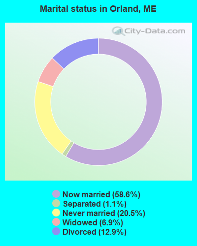
- Never married: 20.5%
- Now married: 58.6%
- Separated: 1.1%
- Widowed: 6.9%
- Divorced: 12.9%
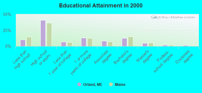
For population 25 years and over in Orland:
- High school or higher: 89.8%
- Bachelor's degree or higher: 20.7%
- Graduate or professional degree: 8.2%
- Unemployed: 5.5%
- Mean travel time to work (commute): 23.7 minutes
| Here: | 10.0 |
| Maine average: | 11.2 |


Graphs represent county-level data. Detailed 2008 Election Results
Religion statistics for Orland, ME (based on Hancock County data)


| Religion | Adherents | Congregations |
|---|---|---|
| Mainline Protestant | 4,691 | 58 |
| Catholic | 2,523 | 9 |
| Evangelical Protestant | 1,288 | 23 |
| Other | 820 | 11 |
| None | 45,096 | - |
Food Environment Statistics:
| Here: | 6.01 / 10,000 pop. |
| State: | 2.80 / 10,000 pop. |
| Here: | 1.69 / 10,000 pop. |
| Maine: | 2.20 / 10,000 pop. |
| Hancock County: | 4.89 / 10,000 pop. |
| Maine: | 5.75 / 10,000 pop. |
| Hancock County: | 21.61 / 10,000 pop. |
| State: | 11.02 / 10,000 pop. |
| Hancock County: | 7.4% |
| Maine: | 8.2% |
| Hancock County: | 25.4% |
| State: | 25.0% |
Businesses in Orland, ME
- MasterBrand Cabinets: 2
Strongest AM radio stations in Orland:
- WABI (910 AM; 5 kW; BANGOR, ME; Owner: CLEAR CHANNEL BROADCASTING LICENSES, INC.)
- WZON (620 AM; 5 kW; BANGOR, ME; Owner: THE ZONE CORPORATION)
- WDEA (1370 AM; 5 kW; ELLSWORTH, ME; Owner: CUMULUS LICENSING CORP.)
- WSKW (1160 AM; 10 kW; SKOWHEGAN, ME; Owner: MOUNTAIN WIRELESS, INCORPORATED)
- WNZS (1340 AM; 1 kW; VEAZIE, ME; Owner: WATERFRONT COMMUNICATIONS INC.)
- WRKO (680 AM; 50 kW; BOSTON, MA; Owner: ENTERCOM BOSTON LICENSE, LLC)
- WTME (780 AM; 10 kW; RUMFORD, ME; Owner: MOUNTAIN VALLEY BROADCASTING, INC.)
- WEEI (850 AM; 50 kW; BOSTON, MA; Owner: ENTERCOM BOSTON LICENSE, LLC)
- WBZ (1030 AM; 50 kW; BOSTON, MA; Owner: INFINITY BROADCASTING OPERATIONS, INC.)
- WCRN (830 AM; 50 kW; WORCESTER, MA; Owner: CARTER BROADCASTING CORPORATION)
- WFAU (1280 AM; 5 kW; GARDINER, ME; Owner: CAPSTAR TX LIMITED PARTNERSHIP)
- WNNZ (640 AM; 50 kW; WESTFIELD, MA; Owner: CLEAR CHANNEL BROADCASTING LICENSES, INC.)
- WKOX (1200 AM; 50 kW; FRAMINGHAM, MA; Owner: CAPSTAR TX LIMITED PARTNERSHIP)
Strongest FM radio stations in Orland:
- WWMJ (95.7 FM; ELLSWORTH, ME; Owner: CUMULUS LICENSING CORP.)
- WKIT-FM (100.3 FM; BREWER, ME; Owner: THE ZONE CORPORATION)
- WBFB (104.7 FM; BELFAST, ME; Owner: CLEAR CHANNEL BROADCASTING LICENSES, INC.)
- WERU-FM (89.9 FM; BLUE HILL, ME; Owner: SALT POND COMMUNITY B/C COMPANY)
- WFZX (101.7 FM; SEARSPORT, ME; Owner: CLEAR CHANNEL BROADCASTING LICENSES, INC.)
- WMEH (90.9 FM; BANGOR, ME; Owner: MAINE PUBLIC BROADCASTING CORPORATION)
- WEZQ (92.9 FM; BANGOR, ME; Owner: CUMULUS LICENSING CORP.)
- WWBX (97.1 FM; BANGOR, ME; Owner: CLEAR CHANNEL BROADCASTING LICENSES, INC.)
- WHCF (88.5 FM; BANGOR, ME; Owner: BANGOR BAPTIST CHURCH)
- WMEP (90.5 FM; CAMDEN, ME; Owner: MAINE PUBLIC BROADCASTING CORP.)
- WQSS (102.5 FM; CAMDEN, ME; Owner: CLEAR CHANNEL BROADCASTING LICENSES, INC.)
- WNSX (97.7 FM; WINTER HARBOR, ME; Owner: CLEAR CHANNEL BROADCASTING LICENSES, INC.)
- WLKE (99.1 FM; BAR HARBOR, ME; Owner: CLEAR CHANNEL BROADCASTING LICENSES, INC.)
- WVOM (103.9 FM; HOWLAND, ME; Owner: CLEAR CHANNEL BROADCASTING LICENSES, INC.)
- WQCB (106.5 FM; BREWER, ME; Owner: CUMULUS LICENSING CORP.)
- WMCM (103.3 FM; ROCKLAND, ME; Owner: CLEAR CHANNEL BROADCASTING LICENSES, INC.)
- WBZN (107.3 FM; OLD TOWN, ME; Owner: CUMULUS LICENSING CORP.)
- WBQI (107.7 FM; BAR HARBOR, ME; Owner: MARINER BROADCASTING, L.P.)
- WBYA (105.5 FM; ISLESBORO, ME; Owner: MARINER BROADCASTING LIMTED PARTNERSHIP)
TV broadcast stations around Orland:
- WCKD-LP (Channel 30; BANGOR/DEDHAM, ME; Owner: J. MCLEOD, ME FAMILY B/CING., INC.)
- WLBZ (Channel 2; BANGOR, ME; Owner: PACIFIC AND SOUTHERN COMPANY, INC.)
- WMEB-TV (Channel 12; ORONO, ME; Owner: MAINE PUBLIC BROADCASTING CORPORATION)
- WBGR-LP (Channel 33; BANGOR/DEDHAM, ME; Owner: MAINE FAMILY BROADCASTING, INC.)
- WABI-TV (Channel 5; BANGOR, ME; Owner: COMMUNITY BROADCASTING SERVICE)
- W66CL (Channel 66; BANGOR, ME; Owner: MS COMMUNICATIONS, LLC)
- WBAN-LP (Channel 9; BANGOR, ME; Owner: BANGOR MEDIA GROUP, LLC)
- W36CK (Channel 36; BANGOR, ME; Owner: TRINITY BROADCASTING NETWORK)
- WVII-TV (Channel 7; BANGOR, ME; Owner: BANGOR COMMUNICATIONS, INC.)
- WFVX-LP (Channel 22; BANGOR, ME; Owner: ROCKFLEET BROADCASTING III, LLC)
- W39CC (Channel 39; BANGOR, ME; Owner: MS COMMUNICATIONS, LLC)
- W42BZ (Channel 42; BANGOR, ME; Owner: MS COMMUNICATIONS, LLC)
- W50BX (Channel 50; BANGOR, ME; Owner: MS COMMUNICATIONS, LLC)
- W54CG (Channel 54; BANGOR, ME; Owner: MS COMMUNICATIONS, LLC)

- National Bridge Inventory (NBI) Statistics
- 3Number of bridges
- 39ft / 11.9mTotal length
- 12,157Total average daily traffic
- 607Total average daily truck traffic
- 17,212Total future (year 2036) average daily traffic
FCC Registered Antenna Towers:
23 (See the full list of FCC Registered Antenna Towers in Orland)FCC Registered Broadcast Land Mobile Towers:
4- 2 Mi S Of Rt 3 On Rt 15 (Lat: 44.530917 Lon: -68.676417), Call Sign: KCC580,
Assigned Frequencies: 47.2200 MHz, 47.2600 MHz, 47.3400 MHz, Grant Date: 05/28/2014, Expiration Date: 07/07/2024, Registrant: State Of Maine, O.I.T., Radio Operations, 66 Industrial Drive, Augusta, ME 04333-0147, Phone: (207) 624-9990, Email:
- Pumping Station Alamoosook Lake Dam (Lat: 44.592583 Lon: -68.722528), Call Sign: KNAF912,
Assigned Frequencies: 154.456 MHz, Grant Date: 03/29/2005, Expiration Date: 04/26/2015, Cancellation Date: 06/27/2015, Registrant: International Paper Co., River Road, Bucksport, ME 04416, Phone: (207) 469-1450
- ORLAND, Rt 15 (Lat: 44.530917 Lon: -68.676417), Type: Tower, Structure height: 41 m, Call Sign: WQEZ823,
Assigned Frequencies: 457.825 MHz, Grant Date: 05/30/2006, Expiration Date: 05/30/2016, Cancellation Date: 07/30/2016, Certifier: William Plante, Registrant: State Of Maine, Department Of Transportation, 66 Industrial Drive, Augusta, ME 04330-7857, Phone: (207) 624-9990, Email:
- 99 Front Ridge Road (Lat: 44.556889 Lon: -68.700833), Type: Bant, Structure height: 4 m, Overall height: 6 m, Call Sign: WRNV769,
Assigned Frequencies: 467.225 MHz, 467.325 MHz, 467.500 MHz, Grant Date: 08/31/2021, Expiration Date: 08/31/2031, Certifier: Ryan Cullen, Registrant: Firstgroup America, Inc, 600 Vine Street, Ste 1400, Cincinnati, OH 45202, Phone: (513) 419-3315, Email:
FCC Registered Microwave Towers:
1- STATION, Page Hill Rte 15 3 Mi E Of Jct Of Rte 3 (Lat: 44.530889 Lon: -68.676389), Overall height: 41.1 m, Call Sign: WAJ995,
Assigned Frequencies: 958.600 MHz, Grant Date: 07/18/2019, Expiration Date: 09/15/2029, Registrant: State Of Maine, O.I.T., Radio Operations, 66 Industrial Drive, Augusta, ME 04333-0147, Phone: (207) 624-9990, Email:
FCC Registered Amateur Radio Licenses:
10 (See the full list of FCC Registered Amateur Radio Licenses in Orland)FAA Registered Aircraft:
3- Aircraft: AERONCA 15AC (Category: Land, Seats: 4, Weight: Up to 12,499 Pounds, Speed: 85 mph), Engine: CONT MOTOR C145 SERIES (145 HP) (Reciprocating)
N-Number: 1192H, N1192H, N-1192H, Serial Number: 15AC-204, Year manufactured: 1948, Airworthiness Date: 07/29/1958, Certificate Issue Date: 04/14/2011
Registrant (Individual): William G Eberhardt, 81 Leaches Point Rd, Orland, ME 04472 - Aircraft: SCHEMPP-HIRTH SHK1 (Category: Land, Weight: Up to 12,499 Pounds, Speed: 60 mph), Engine: None
N-Number: 909D, N909D, N-909D, Serial Number: 7, Certificate Issue Date: 05/05/2016
Registrant (Individual): William G Eberhardt, 81 Leaches Point Rd, Orland, ME 04472 - Aircraft: MOONEY M20C (Category: Land, Seats: 4, Weight: Up to 12,499 Pounds, Speed: 127 mph), Engine: LYCOMING O&VO-360 SER (180 HP) (Reciprocating)
N-Number: 9357V, N9357V, N-9357V, Serial Number: 700013, Year manufactured: 1969, Airworthiness Date: 10/24/1969, Certificate Issue Date: 11/06/1978
Registrant (Individual): Edward H Mullins, Po Box 462, Orland, ME 04472
2003 - 2018 National Fire Incident Reporting System (NFIRS) incidents
- Fire incident types reported to NFIRS in Orland, ME
- 10148.8%Structure Fires
- 7636.7%Outside Fires
- 2713.0%Mobile Property/Vehicle Fires
- 31.4%Other
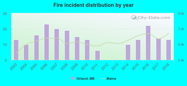 According to the data from the years 2003 - 2018 the average number of fire incidents per year is 13. The highest number of fires - 23 took place in 2006, and the least - 0 in 2012. The data has a constant trend.
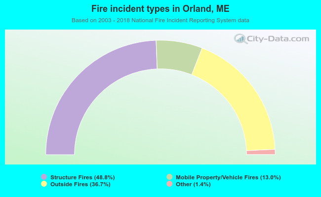 When looking into fire subcategories, the most reports belonged to: Structure Fires (48.8%), and Outside Fires (36.7%).
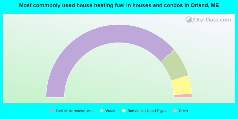
- 77.4%Fuel oil, kerosene, etc.
- 12.8%Wood
- 8.2%Bottled, tank, or LP gas
- 0.7%Electricity
- 0.3%Utility gas
- 0.3%Solar energy
- 0.3%Other fuel
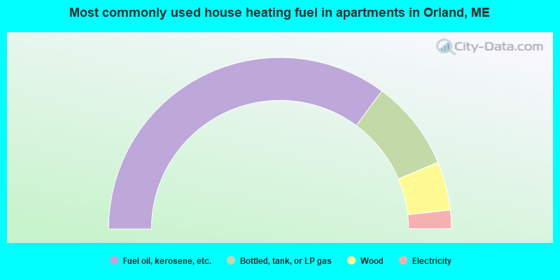
- 70.2%Fuel oil, kerosene, etc.
- 17.0%Bottled, tank, or LP gas
- 9.2%Wood
- 3.5%Electricity
Orland compared to Maine state average:
- Unemployed percentage below state average.
- Black race population percentage significantly below state average.
- Hispanic race population percentage below state average.
- Median age above state average.
- Foreign-born population percentage significantly below state average.
- Renting percentage below state average.
- Length of stay since moving in significantly above state average.
- Number of rooms per house significantly below state average.
- House age significantly below state average.