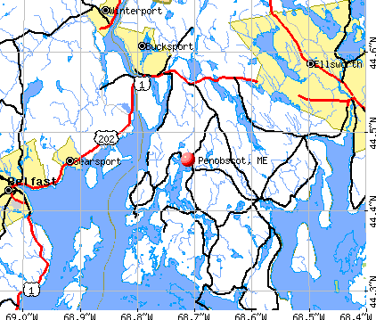
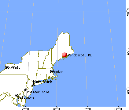
Penobscot, Maine
Submit your own pictures of this town and show them to the world
- OSM Map
- General Map
- Google Map
- MSN Map
Population change since 2000: -6.0%
 |
| Males: 615 | |
| Females: 648 |
| Median resident age: | 51.9 years |
| Maine median age: | 43.0 years |
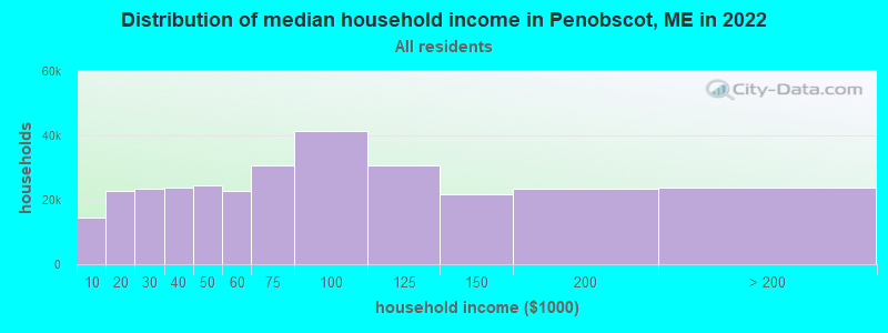
| Penobscot: | $67,957 |
| ME: | $69,543 |
Estimated per capita income in 2022: $40,679 (it was $20,035 in 2000)
Penobscot town income, earnings, and wages data
Estimated median house or condo value in 2022: $274,071 (it was $95,700 in 2000)
| Penobscot: | $274,071 |
| ME: | $290,600 |
Mean prices in 2022: all housing units: $379,336; detached houses: $396,802; townhouses or other attached units: $600,716; in 2-unit structures: $274,479; in 3-to-4-unit structures: $212,346; in 5-or-more-unit structures: $146,369; mobile homes: $158,183; occupied boats, rvs, vans, etc.: $16,454
Detailed information about poverty and poor residents in Penobscot, ME


- 1,22196.7%White alone
- 151.2%Two or more races
- 121.0%Hispanic
- 80.6%Asian alone
- 50.4%American Indian alone
- 20.2%Black alone
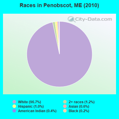
Races in Penobscot detailed stats: ancestries, foreign born residents, place of birth
According to our research of Maine and other state lists, there was 1 registered sex offender living in Penobscot, Maine as of May 08, 2024.
The ratio of all residents to sex offenders in Penobscot is 1,263 to 1.
The ratio of registered sex offenders to all residents in this city is much lower than the state average.
 Recent articles from our blog. Our writers, many of them Ph.D. graduates or candidates, create easy-to-read articles on a wide variety of topics.

 | Maine woods/vegetation/bogs near Bangor/Old Town for solo camping (35 replies) |
| Suggestions for a Quiet Cottage in the Forest (49 replies) |
| Fresh Fish you can eat from the lake or pond (17 replies) |
| What are regulations for DIY cabin construction in off grid rural areas of Maine (14 replies) |
| Canoe Trip Advice Sought (26 replies) |
| Most conservative county & best vehicle in Maine? (36 replies) |
Latest news from Penobscot, ME collected exclusively by city-data.com from local newspapers, TV, and radio stations
Ancestries: English (23.5%), United States (17.5%), Irish (9.9%), German (6.8%), Scottish (5.7%), French (4.5%).
Current Local Time: EST time zone
Incorporated on 02/23/1787
Elevation: 54 feet
Land area: 39.8 square miles.
Population density: 32 people per square mile (very low).
21 residents are foreign born
| This town: | 1.6% |
| Maine: | 2.9% |
| Penobscot town: | 1.0% ($937) |
| Maine: | 1.5% ($1,417) |
Nearest city with pop. 50,000+: Portland, ME  (95.1 miles , pop. 64,249).
Nearest city with pop. 200,000+: Boston, MA (190.3 miles , pop. 589,141).
Nearest city with pop. 1,000,000+: Bronx, NY (362.5 miles , pop. 1,332,650).
Nearest cities:
), ), Latitude: 44.46 N, Longitude: 68.71 W
Area code commonly used in this area: 207

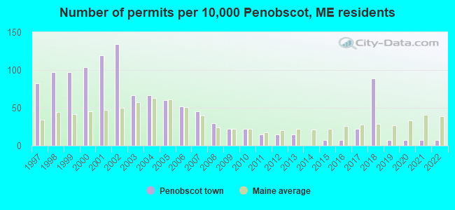
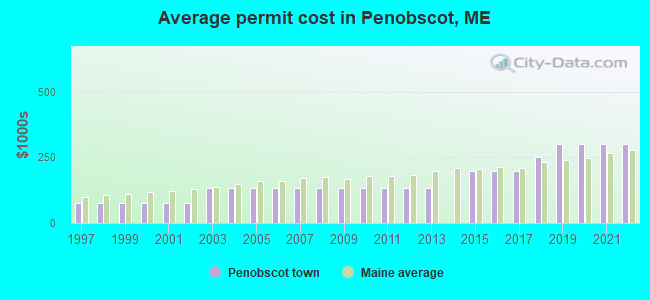
Single-family new house construction building permits:
- 2022: 1 building, cost: $300,000
- 2021: 1 building, cost: $300,000
- 2020: 1 building, cost: $300,000
- 2019: 1 building, cost: $300,000
- 2018: 12 buildings, average cost: $249,800
- 2017: 3 buildings, average cost: $200,000
- 2016: 1 building, cost: $200,000
- 2015: 1 building, cost: $200,000
- 2013: 2 buildings, average cost: $132,800
- 2012: 2 buildings, average cost: $132,800
- 2011: 2 buildings, average cost: $132,800
- 2010: 3 buildings, average cost: $132,800
- 2009: 3 buildings, average cost: $132,800
- 2008: 4 buildings, average cost: $132,800
- 2007: 6 buildings, average cost: $132,800
- 2006: 7 buildings, average cost: $132,800
- 2005: 8 buildings, average cost: $132,800
- 2004: 9 buildings, average cost: $132,800
- 2003: 9 buildings, average cost: $132,800
- 2002: 18 buildings, average cost: $78,200
- 2001: 16 buildings, average cost: $78,200
- 2000: 14 buildings, average cost: $78,200
- 1999: 13 buildings, average cost: $78,200
- 1998: 13 buildings, average cost: $78,200
- 1997: 11 buildings, average cost: $78,200
| Here: | 2.4% |
| Maine: | 3.4% |

- Health care (14.9%)
- Construction (13.1%)
- Educational services (12.6%)
- Accommodation & food services (6.5%)
- Paper (6.2%)
- Agriculture, forestry, fishing & hunting (3.9%)
- Transportation equipment (3.4%)
- Construction (21.4%)
- Educational services (11.6%)
- Paper (10.7%)
- Transportation equipment (5.5%)
- Accommodation & food services (5.2%)
- Agriculture, forestry, fishing & hunting (4.9%)
- Health care (3.1%)

- Health care (29.3%)
- Educational services (13.7%)
- Accommodation & food services (8.1%)
- Social assistance (5.2%)
- Food & beverage stores (4.4%)
- Religious, grantmaking, civic, professional, similar organizations (3.7%)
- Professional, scientific, technical services (3.3%)
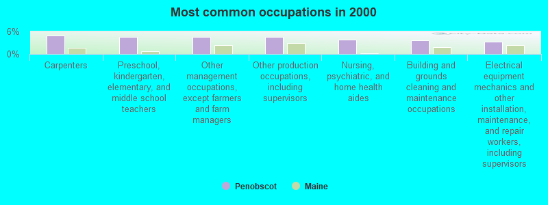
- Carpenters (4.9%)
- Preschool, kindergarten, elementary, and middle school teachers (4.5%)
- Other management occupations, except farmers and farm managers (4.5%)
- Other production occupations, including supervisors (4.5%)
- Nursing, psychiatric, and home health aides (3.9%)
- Building and grounds cleaning and maintenance occupations (3.7%)
- Electrical equipment mechanics and other installation, maintenance, and repair workers, including supervisors (3.4%)

- Carpenters (8.6%)
- Other production occupations, including supervisors (7.6%)
- Electrical equipment mechanics and other installation, maintenance, and repair workers, including supervisors (5.8%)
- Other management occupations, except farmers and farm managers (5.2%)
- Vehicle and mobile equipment mechanics, installers, and repairers (4.3%)
- Supervisors, construction and extraction workers (3.4%)
- Building and grounds cleaning and maintenance occupations (3.1%)

- Preschool, kindergarten, elementary, and middle school teachers (8.9%)
- Nursing, psychiatric, and home health aides (8.1%)
- Registered nurses (7.0%)
- Health technologists and technicians (6.7%)
- Secretaries and administrative assistants (5.6%)
- Waiters and waitresses (4.8%)
- Building and grounds cleaning and maintenance occupations (4.4%)
Average climate in Penobscot, Maine
Based on data reported by over 4,000 weather stations


(lower is better)
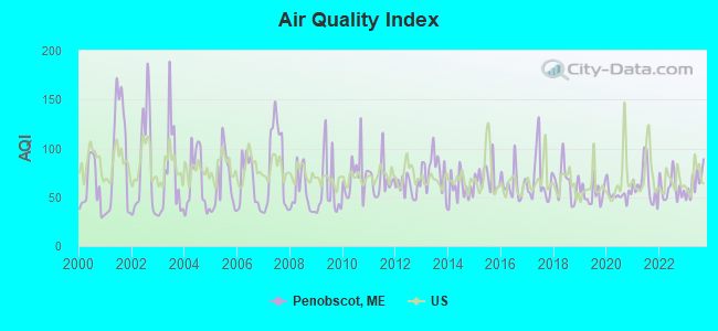
Air Quality Index (AQI) level in 2023 was 65.0. This is about average.
| City: | 65.0 |
| U.S.: | 72.6 |
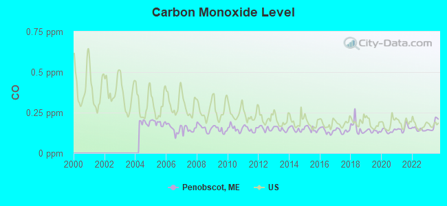
Carbon Monoxide (CO) [ppm] level in 2023 was 0.172. This is significantly better than average. Closest monitor was 13.8 miles away from the city center.
| City: | 0.172 |
| U.S.: | 0.251 |
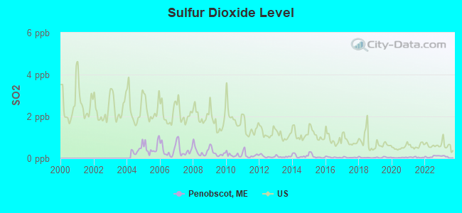
Sulfur Dioxide (SO2) [ppb] level in 2023 was 0.0636. This is significantly better than average. Closest monitor was 6.8 miles away from the city center.
| City: | 0.0636 |
| U.S.: | 1.5147 |
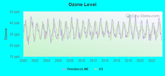
Ozone [ppb] level in 2023 was 35.1. This is about average. Closest monitor was 5.4 miles away from the city center.
| City: | 35.1 |
| U.S.: | 33.3 |
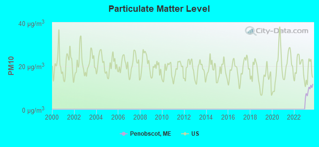
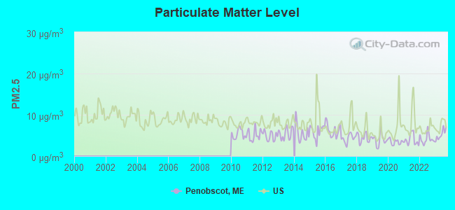
Particulate Matter (PM2.5) [µg/m3] level in 2023 was 5.23. This is significantly better than average. Closest monitor was 23.1 miles away from the city center.
| City: | 5.23 |
| U.S.: | 8.11 |
Earthquake activity:
Penobscot-area historical earthquake activity is significantly above Maine state average. It is 80% smaller than the overall U.S. average.On 10/16/2012 at 23:12:25, a magnitude 4.7 (4.7 ML, Depth: 10.0 mi, Class: Light, Intensity: IV - V) earthquake occurred 113.7 miles away from the city center
On 4/20/2002 at 10:50:47, a magnitude 5.3 (5.3 ML, Depth: 3.0 mi, Class: Moderate, Intensity: VI - VII) earthquake occurred 246.0 miles away from Penobscot center
On 4/20/2002 at 10:50:47, a magnitude 5.2 (5.2 MB, 4.2 MS, 5.2 MW, 5.0 MW) earthquake occurred 247.0 miles away from Penobscot center
On 1/19/1982 at 00:14:42, a magnitude 4.7 (4.5 MB, 4.7 MD, 4.5 LG) earthquake occurred 158.4 miles away from Penobscot center
On 10/7/1983 at 10:18:46, a magnitude 5.3 (5.1 MB, 5.3 LG, 5.1 ML) earthquake occurred 281.3 miles away from the city center
On 2/26/1999 at 03:38:43, a magnitude 3.8 (3.8 LG, Depth: 2.0 mi, Class: Light, Intensity: II - III) earthquake occurred 39.9 miles away from the city center
Magnitude types: regional Lg-wave magnitude (LG), body-wave magnitude (MB), duration magnitude (MD), local magnitude (ML), surface-wave magnitude (MS), moment magnitude (MW)
Natural disasters:
The number of natural disasters in Hancock County (18) is near the US average (15).Major Disasters (Presidential) Declared: 11
Emergencies Declared: 6
Causes of natural disasters: Floods: 9, Storms: 8, Snows: 5, Blizzard: 1, Heavy Rain: 1, Hurricane: 1, Ice Storm: 1, Landslide: 1, Snowfall: 1, Wind: 1, Winter Storm: 1, Other: 2 (Note: some incidents may be assigned to more than one category).
Hospitals and medical centers in Penobscot:
Other hospitals and medical centers near Penobscot:
- WALDO COUNTY GENERAL HOSPITAL Critical Access Hospitals (about 15 miles away; BELFAST, ME)
- DIALYSIS CLINIC INC. - BELFAST (Dialysis Facility, about 15 miles away; BELFAST, ME)
- BRADBURY MANOR (Nursing Home, about 15 miles away; BELFAST, ME)
- THE COMMONS AT TALL PINES (Nursing Home, about 15 miles away; BELFAST, ME)
- HARBOR HILL CENTER (Nursing Home, about 15 miles away; BELFAST, ME)
- COURTLAND REHAB AND LIVING CENTER (Nursing Home, about 15 miles away; ELLSWORTH, ME)
- COLLIER'S REHAB AND NURSING CTR (Nursing Home, about 16 miles away; ELLSWORTH, ME)
Colleges/universities with over 2000 students nearest to Penobscot:
- Husson University (about 26 miles; Bangor, ME; Full-time enrollment: 2,421)
- University of Maine (about 30 miles; Orono, ME; FT enrollment: 8,931)
- University of Maine at Augusta (about 55 miles; Augusta, ME; FT enrollment: 3,204)
- University of Maine at Farmington (about 73 miles; Farmington, ME; FT enrollment: 2,036)
- Southern Maine Community College (about 95 miles; South Portland, ME; FT enrollment: 4,666)
- University of Southern Maine (about 96 miles; Portland, ME; FT enrollment: 6,647)
- Saint Joseph's College of Maine (about 99 miles; Standish, ME; FT enrollment: 2,010)
Public elementary/middle school in Penobscot:
- PENOBSCOT ELEMENTARY SCHOOL (Location: NO PHYSICAL LOCATION AVAILABLE, Grades: PK-8)
Points of interest:
Notable locations in Penobscot: Penobscot Volunteer Fire Department Storage (A), Penobscot Volunteer Fire Department Main Station (B). Display/hide their locations on the map
Churches in Penobscot include: Penobscot Church (A), Penobscot United Methodist Church (B). Display/hide their locations on the map
Cemeteries: Bay Cemetery (1), South Penobscot Cemetery (2), Bridges Cemetery (3), Westcott Cemetery (4), Perry Cemetery (5), Leach Cemetery (6), Hutchins Cemetery (7). Display/hide their locations on the map
Lakes, reservoirs, and swamps: Turtle Pond (A), Wight Pond (B), Pierce Pond (C), Toddy Pond (D), Great Heath (E). Display/hide their locations on the map
Streams, rivers, and creeks: Seneca Brook (A), Winslow Stream (B), Moore Brook (C), Smell Brook (D), McCaslin Stream (E), Turtle Pond Brook (F), Mill Brook (G), Clements Brook (H). Display/hide their locations on the map
Birthplace of: George W. Emery - 11th Governor of the Territory of Utah.
Drinking water stations with addresses in Penobscot and their reported violations in the past:
PENOBSCOT NURSING HOME (Population served: 150, Groundwater):Past health violations:SOUTH PENOBSCOT WATER ASSOC (Population served: 30, Groundwater):Past monitoring violations:
- MCL, Monthly (TCR) - In FEB-2006, Contaminant: Coliform. Follow-up actions: St Public Notif requested (FEB-13-2006), St Violation/Reminder Notice (FEB-13-2006), St Compliance achieved (OCT-11-2006), St Public Notif received (JUL-01-2008)
- MCL, Monthly (TCR) - In JAN-2006, Contaminant: Coliform. Follow-up actions: St Public Notif requested (JAN-27-2006), St Violation/Reminder Notice (JAN-27-2006), St Compliance achieved (OCT-11-2006), St Public Notif received (JUL-01-2008)
- MCL, Monthly (TCR) - In DEC-2005, Contaminant: Coliform. Follow-up actions: St Public Notif requested (DEC-19-2005), St Violation/Reminder Notice (DEC-19-2005), St Public Notif received (2 times from DEC-29-2005 to DEC-29-2005), St Compliance achieved (OCT-11-2006)
- MCL, Monthly (TCR) - In NOV-2005, Contaminant: Coliform. Follow-up actions: St Violation/Reminder Notice (NOV-14-2005), St Public Notif requested (NOV-14-2005), St Compliance achieved (OCT-11-2006), St Intentional no-action (AUG-19-2011)
- MCL, Monthly (TCR) - In AUG-2005, Contaminant: Coliform. Follow-up actions: St Violation/Reminder Notice (AUG-19-2005), St Public Notif requested (AUG-19-2005), St Compliance achieved (OCT-11-2006), St Intentional no-action (AUG-19-2011)
- MCL, Monthly (TCR) - In JUL-2005, Contaminant: Coliform. Follow-up actions: St Violation/Reminder Notice (AUG-08-2005), St Public Notif requested (AUG-08-2005), St Public Notif received (2 times from AUG-25-2005 to AUG-25-2005), St Compliance achieved (OCT-11-2006)
- Follow-up Or Routine LCR Tap M/R - In JUL-01-2011, Contaminant: Lead and Copper Rule. Follow-up actions: St Public Notif requested (AUG-25-2011), St Formal NOV issued (AUG-25-2011), St Public Notif received (AUG-31-2011), St Compliance achieved (AUG-31-2011)
- Follow-up Or Routine LCR Tap M/R - In OCT-01-2008, Contaminant: Lead and Copper Rule. Follow-up actions: St Public Notif requested (DEC-09-2008), St Formal NOV issued (DEC-09-2008), St Compliance achieved (MAR-18-2010), St Intentional no-action (SEP-15-2011)
- Monitoring and Reporting (DBP) - Between JAN-2008 and DEC-2010, Contaminant: TTHM. Follow-up actions: St Public Notif requested (APR-16-2010), St Formal NOV issued (APR-16-2010), St Compliance achieved (JUN-21-2010), St Public Notif received (APR-12-2012)
- Monitoring and Reporting (DBP) - Between JAN-2008 and DEC-2010, Contaminant: Total Haloacetic Acids (HAA5). Follow-up actions: St Public Notif requested (APR-16-2010), St Formal NOV issued (APR-16-2010), St Compliance achieved (JUN-21-2010), St Public Notif received (APR-12-2012)
- One routine major monitoring violation
- One regular monitoring violation
Past monitoring violations:
- Follow-up Or Routine LCR Tap M/R - In OCT-01-2009, Contaminant: Lead and Copper Rule. Follow-up actions: St Public Notif requested (DEC-28-2009), St Formal NOV issued (DEC-28-2009), St Intentional no-action (AUG-26-2011), St Compliance achieved (AUG-29-2011)
- Follow-up Or Routine LCR Tap M/R - In JAN-01-2007, Contaminant: Lead and Copper Rule. Follow-up actions: St Public Notif requested (FEB-20-2007), St Violation/Reminder Notice (FEB-20-2007), St Compliance achieved (AUG-04-2008), St Intentional no-action (AUG-26-2011)
- Monitoring and Reporting (DBP) - Between JAN-2005 and DEC-2007, Contaminant: TTHM. Follow-up actions: St Public Notif requested (APR-17-2008), St Formal NOV issued (APR-17-2008), St Compliance achieved (AUG-19-2008), St Intentional no-action (AUG-26-2011)
- Monitoring and Reporting (DBP) - Between JAN-2005 and DEC-2007, Contaminant: Total Haloacetic Acids (HAA5). Follow-up actions: St Public Notif requested (APR-17-2008), St Formal NOV issued (APR-17-2008), St Compliance achieved (AUG-19-2008), St Intentional no-action (AUG-26-2011)
| This town: | 2.1 people |
| Maine: | 2.3 people |
| This town: | 58.5% |
| Whole state: | 62.9% |
| This town: | 8.6% |
| Whole state: | 9.4% |
Likely homosexual households (counted as self-reported same-sex unmarried-partner households)
- Lesbian couples: 0.8% of all households
- Gay men: 0.0% of all households
| This town: | 8.0% |
| Whole state: | 10.9% |
| This town: | 3.5% |
| Whole state: | 4.1% |
87 people in nursing homes in 2000
For population 15 years and over in Penobscot:
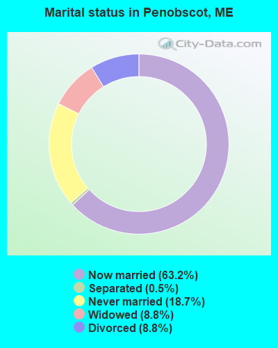
- Never married: 18.7%
- Now married: 63.2%
- Separated: 0.5%
- Widowed: 8.8%
- Divorced: 8.8%
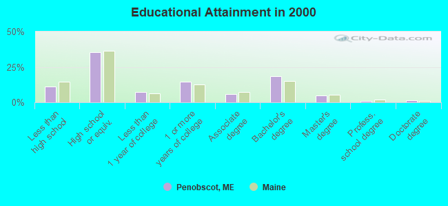
For population 25 years and over in Penobscot:
- High school or higher: 88.8%
- Bachelor's degree or higher: 25.8%
- Graduate or professional degree: 7.2%
- Unemployed: 5.8%
- Mean travel time to work (commute): 23.4 minutes

| Here: | 10.1 |
| Maine average: | 11.2 |


Graphs represent county-level data. Detailed 2008 Election Results
Religion statistics for Penobscot, ME (based on Hancock County data)


| Religion | Adherents | Congregations |
|---|---|---|
| Mainline Protestant | 4,691 | 58 |
| Catholic | 2,523 | 9 |
| Evangelical Protestant | 1,288 | 23 |
| Other | 820 | 11 |
| None | 45,096 | - |
Food Environment Statistics:
| This county: | 6.01 / 10,000 pop. |
| Maine: | 2.80 / 10,000 pop. |
| Here: | 1.69 / 10,000 pop. |
| Maine: | 2.20 / 10,000 pop. |
| Hancock County: | 4.89 / 10,000 pop. |
| Maine: | 5.75 / 10,000 pop. |
| Hancock County: | 21.61 / 10,000 pop. |
| Maine: | 11.02 / 10,000 pop. |
| Hancock County: | 7.4% |
| State: | 8.2% |
| Hancock County: | 25.4% |
| Maine: | 25.0% |
Strongest AM radio stations in Penobscot:
- WDEA (1370 AM; 5 kW; ELLSWORTH, ME; Owner: CUMULUS LICENSING CORP.)
- WZON (620 AM; 5 kW; BANGOR, ME; Owner: THE ZONE CORPORATION)
- WABI (910 AM; 5 kW; BANGOR, ME; Owner: CLEAR CHANNEL BROADCASTING LICENSES, INC.)
- WSKW (1160 AM; 10 kW; SKOWHEGAN, ME; Owner: MOUNTAIN WIRELESS, INCORPORATED)
- WRKO (680 AM; 50 kW; BOSTON, MA; Owner: ENTERCOM BOSTON LICENSE, LLC)
- WTME (780 AM; 10 kW; RUMFORD, ME; Owner: MOUNTAIN VALLEY BROADCASTING, INC.)
- WEEI (850 AM; 50 kW; BOSTON, MA; Owner: ENTERCOM BOSTON LICENSE, LLC)
- WBZ (1030 AM; 50 kW; BOSTON, MA; Owner: INFINITY BROADCASTING OPERATIONS, INC.)
- WFAU (1280 AM; 5 kW; GARDINER, ME; Owner: CAPSTAR TX LIMITED PARTNERSHIP)
- WCRN (830 AM; 50 kW; WORCESTER, MA; Owner: CARTER BROADCASTING CORPORATION)
- WNNZ (640 AM; 50 kW; WESTFIELD, MA; Owner: CLEAR CHANNEL BROADCASTING LICENSES, INC.)
- WNZS (1340 AM; 1 kW; VEAZIE, ME; Owner: WATERFRONT COMMUNICATIONS INC.)
- WMTW (870 AM; 10 kW; GORHAM, ME; Owner: RADIO PARTNERS OF MAINE, L.P.)
Strongest FM radio stations in Penobscot:
- WERU-FM (89.9 FM; BLUE HILL, ME; Owner: SALT POND COMMUNITY B/C COMPANY)
- WFZX (101.7 FM; SEARSPORT, ME; Owner: CLEAR CHANNEL BROADCASTING LICENSES, INC.)
- WBFB (104.7 FM; BELFAST, ME; Owner: CLEAR CHANNEL BROADCASTING LICENSES, INC.)
- WWMJ (95.7 FM; ELLSWORTH, ME; Owner: CUMULUS LICENSING CORP.)
- WKIT-FM (100.3 FM; BREWER, ME; Owner: THE ZONE CORPORATION)
- WWBX (97.1 FM; BANGOR, ME; Owner: CLEAR CHANNEL BROADCASTING LICENSES, INC.)
- WMEP (90.5 FM; CAMDEN, ME; Owner: MAINE PUBLIC BROADCASTING CORP.)
- WQSS (102.5 FM; CAMDEN, ME; Owner: CLEAR CHANNEL BROADCASTING LICENSES, INC.)
- WMEH (90.9 FM; BANGOR, ME; Owner: MAINE PUBLIC BROADCASTING CORPORATION)
- WEZQ (92.9 FM; BANGOR, ME; Owner: CUMULUS LICENSING CORP.)
- WNSX (97.7 FM; WINTER HARBOR, ME; Owner: CLEAR CHANNEL BROADCASTING LICENSES, INC.)
- WHCF (88.5 FM; BANGOR, ME; Owner: BANGOR BAPTIST CHURCH)
- WLKE (99.1 FM; BAR HARBOR, ME; Owner: CLEAR CHANNEL BROADCASTING LICENSES, INC.)
- WVOM (103.9 FM; HOWLAND, ME; Owner: CLEAR CHANNEL BROADCASTING LICENSES, INC.)
- WMCM (103.3 FM; ROCKLAND, ME; Owner: CLEAR CHANNEL BROADCASTING LICENSES, INC.)
- WBYA (105.5 FM; ISLESBORO, ME; Owner: MARINER BROADCASTING LIMTED PARTNERSHIP)
- WBQX (106.9 FM; THOMASTON, ME; Owner: MARINER BROADCASTING LIMITED PARTNER)
- WBQI (107.7 FM; BAR HARBOR, ME; Owner: MARINER BROADCASTING, L.P.)
TV broadcast stations around Penobscot:
- WABI-TV (Channel 5; BANGOR, ME; Owner: COMMUNITY BROADCASTING SERVICE)
- WCKD-LP (Channel 30; BANGOR/DEDHAM, ME; Owner: J. MCLEOD, ME FAMILY B/CING., INC.)
- WMEB-TV (Channel 12; ORONO, ME; Owner: MAINE PUBLIC BROADCASTING CORPORATION)
- WLBZ (Channel 2; BANGOR, ME; Owner: PACIFIC AND SOUTHERN COMPANY, INC.)
- WBGR-LP (Channel 33; BANGOR/DEDHAM, ME; Owner: MAINE FAMILY BROADCASTING, INC.)
- W36CK (Channel 36; BANGOR, ME; Owner: TRINITY BROADCASTING NETWORK)
- W66CL (Channel 66; BANGOR, ME; Owner: MS COMMUNICATIONS, LLC)
- Penobscot, Maine
- Fatal accident count13
- Vehicles involved in fatal accidents16
- Fatal accidents involving drunk persons:7
- Fatalities14
- Persons involved in fatal accidents25
- Pedestrians involved in fatal accidents0
- Maine average
- Fatal accident count2241
- Vehicles involved in fatal accidents3248
- Fatal accidents involving drunk persons847
- Fatalities2470
- Persons involved in fatal accidents5497
- Pedestrians involved in fatal accidents209
- National Bridge Inventory (NBI) Statistics
- 1Number of bridges
- 3ft / 0.7mTotal length
- 2,051Total average daily traffic
- 102Total average daily truck traffic
- 2,871Total future (year 2036) average daily traffic
FCC Registered Antenna Towers:
5- Lois L Mills, E Side Of W Etna Rd .3 Km Se Int With Valley Rd (Lat: 44.803056 Lon: -69.167778), Type: 60.7, Overall height: 60.7 m, Registrant: Csn International, Loism@csnradio.Com, , Twin -Falls, Phone: (208) 734-6633
- Todd J Bowman, Northwesterly Of Routes 175 & 199, Hutchins Mountain Near Mill Creek Road (Lat: 44.481861 Lon: -68.738083), Type: 59.4, Overall height: 59.4 m, Registrant: Florida Tower Partners, LLC Dba North Atlantic Towers, Tbowman@tarpontowers.Com, , Brade-nton, Phone: (941) 757-5010
- Todd J Bowman, Northwesterly Of Routes 175 & 199, Hutchins Mountain Near Mill Creek Road (Lat: 44.481861 Lon: -68.738083), Type: 59.4, Overall height: 59.4 m, Registrant: Florida Tower Partners, LLC Dba North Atlantic Towers, Tbowman@tarpontowers.Com, , Brade-nton, Phone: (941) 757-5010
- Bridget Carter, Northwesterly Of Routes 175 & 199, Hutchins Mountain Near Mill Creek Road (Lat: 44.481861 Lon: -68.738083), Type: 59.4, Structure height: 23009 m, Overall height: 59.4 m, Registrant: Florida Tower Partners, LLC Dba North Atlantic Towers, Tbowman@tarpontowers.Com, , Brade-nton, Phone: (941) 757-5010
- E Side Of W Etna Rd .3 Km Se Int With Valley Rd (Lat: 44.803056 Lon: -69.167778), Type: 60.7, Overall height: 60.7 m, Registrant: Csn International, Santa- Ana, Phone: (714) 979-0706
FCC Registered Amateur Radio Licenses:
16 (See the full list of FCC Registered Amateur Radio Licenses in Penobscot)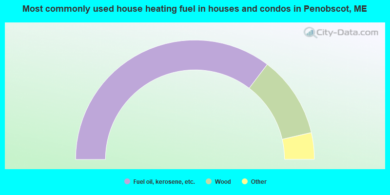
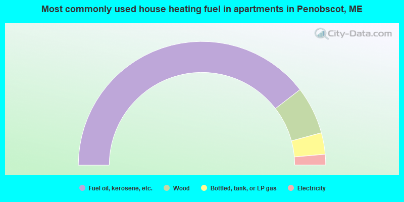
- 70.7%Fuel oil, kerosene, etc.
- 22.1%Wood
- 3.7%Electricity
- 3.0%Bottled, tank, or LP gas
- 0.4%Other fuel
- 79.2%Fuel oil, kerosene, etc.
- 12.5%Wood
- 5.6%Bottled, tank, or LP gas
- 2.8%Electricity
Penobscot compared to Maine state average:
- Unemployed percentage below state average.
- Black race population percentage significantly below state average.
- Hispanic race population percentage below state average.
- Median age significantly above state average.
- Foreign-born population percentage significantly below state average.
- Renting percentage below state average.
- Length of stay since moving in significantly above state average.
- Number of rooms per house significantly below state average.
- House age significantly below state average.
- Institutionalized population percentage above state average.

|
Total of 5 patent applications in 2008-2024.