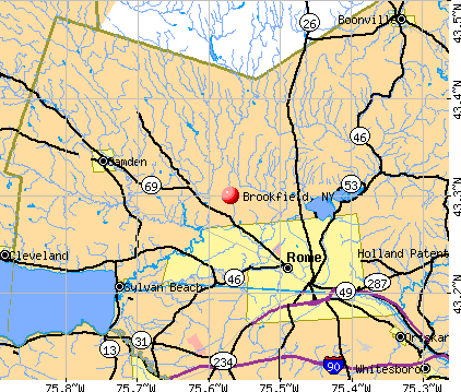
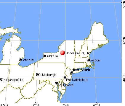
Brookfield, New York

Submit your own pictures of this town and show them to the world
- OSM Map
- General Map
- Google Map
- MSN Map
Population change since 2000: +5.9%
 |
| Males: 1,253 | |
| Females: 1,292 |
| Median resident age: | 39.9 years |
| New York median age: | 40.7 years |
Zip codes: 13314.
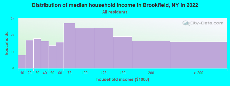
| Brookfield: | $54,959 |
| NY: | $79,557 |
Estimated per capita income in 2022: $26,367 (it was $13,719 in 2000)
Brookfield town income, earnings, and wages data
Estimated median house or condo value in 2022: $99,548 (it was $47,800 in 2000)
| Brookfield: | $99,548 |
| NY: | $400,400 |
Mean prices in 2022: all housing units: $228,996; detached houses: $251,711; townhouses or other attached units: $223,213; in 2-unit structures: $190,364; in 3-to-4-unit structures: $208,959; in 5-or-more-unit structures: $313,705; mobile homes: $82,599
Detailed information about poverty and poor residents in Brookfield, NY


- 2,47297.1%White alone
- 251.0%Two or more races
- 220.9%Hispanic
- 120.5%Asian alone
- 80.3%American Indian alone
- 30.1%Black alone
- 30.1%Other race alone
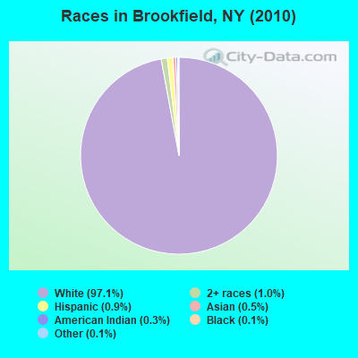
Races in Brookfield detailed stats: ancestries, foreign born residents, place of birth
According to our research of New York and other state lists, there was 1 registered sex offender living in Brookfield, New York as of May 10, 2024.
The ratio of all residents to sex offenders in Brookfield is 2,545 to 1.
The ratio of registered sex offenders to all residents in this city is much lower than the state average.
 Recent articles from our blog. Our writers, many of them Ph.D. graduates or candidates, create easy-to-read articles on a wide variety of topics.


Latest news from Brookfield, NY collected exclusively by city-data.com from local newspapers, TV, and radio stations
Ancestries: English (23.1%), Irish (15.4%), United States (13.7%), German (11.2%), Welsh (6.3%), Italian (6.0%).
Current Local Time: EST time zone
Land area: 77.9 square miles.
Population density: 33 people per square mile (very low).
36 residents are foreign born
| This town: | 1.5% |
| New York: | 20.4% |
| Brookfield town: | 2.4% ($1,160) |
| New York: | 1.9% ($2,847) |
Nearest city with pop. 50,000+: Utica, NY  (21.0 miles , pop. 60,651).
Nearest city with pop. 200,000+: Rochester, NY (117.4 miles , pop. 219,773).
Nearest city with pop. 1,000,000+: Bronx, NY (155.2 miles , pop. 1,332,650).
Nearest cities:
), ), ), ), Latitude: 42.80 N, Longitude: 75.34 W
Area code: 315

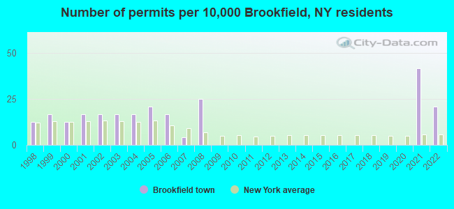
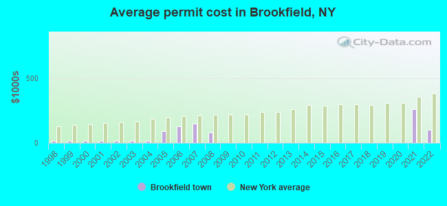
Single-family new house construction building permits:
- 2022: 5 buildings, average cost: $99,000
- 2021: 10 buildings, average cost: $262,500
- 2008: 6 buildings, average cost: $77,500
- 2007: 1 building, cost: $150,000
- 2006: 4 buildings, average cost: $130,100
- 2005: 5 buildings, average cost: $93,100
- 2004: 4 buildings, average cost: $15,000
- 2003: 4 buildings, average cost: $15,000
- 2002: 4 buildings, average cost: $15,000
- 2001: 4 buildings, average cost: $15,000
- 2000: 3 buildings, average cost: $15,000
- 1999: 4 buildings, average cost: $15,000
- 1998: 3 buildings, average cost: $16,700
| Here: | 4.4% |
| New York: | 4.4% |
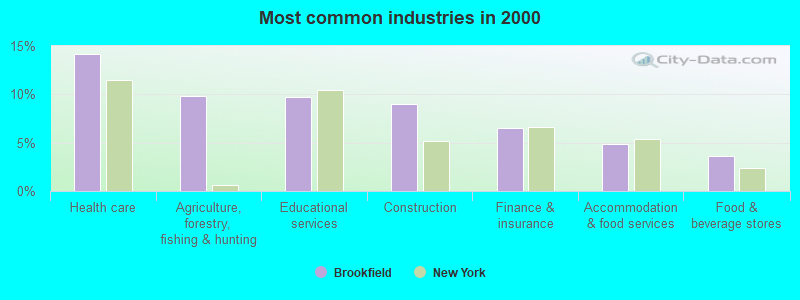
- Health care (14.2%)
- Agriculture, forestry, fishing & hunting (9.8%)
- Educational services (9.7%)
- Construction (9.0%)
- Finance & insurance (6.5%)
- Accommodation & food services (4.9%)
- Food & beverage stores (3.6%)
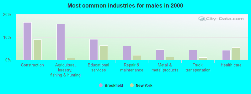
- Construction (16.6%)
- Agriculture, forestry, fishing & hunting (15.8%)
- Educational services (9.2%)
- Repair & maintenance (6.2%)
- Metal & metal products (4.6%)
- Truck transportation (4.4%)
- Health care (4.3%)
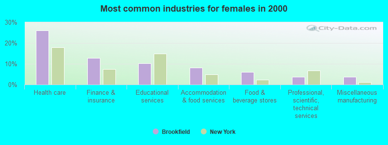
- Health care (26.0%)
- Finance & insurance (12.7%)
- Educational services (10.3%)
- Accommodation & food services (8.0%)
- Food & beverage stores (6.0%)
- Professional, scientific, technical services (3.7%)
- Miscellaneous manufacturing (3.7%)

- Building and grounds cleaning and maintenance occupations (6.8%)
- Farmers and farm managers (5.9%)
- Other production occupations, including supervisors (5.1%)
- Other office and administrative support workers, including supervisors (4.8%)
- Nursing, psychiatric, and home health aides (4.7%)
- Cashiers (3.8%)
- Driver/sales workers and truck drivers (3.8%)
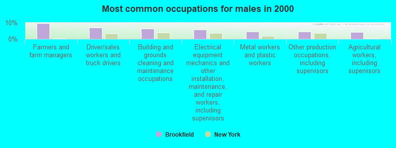
- Farmers and farm managers (9.8%)
- Driver/sales workers and truck drivers (7.0%)
- Building and grounds cleaning and maintenance occupations (6.3%)
- Electrical equipment mechanics and other installation, maintenance, and repair workers, including supervisors (5.8%)
- Metal workers and plastic workers (4.4%)
- Other production occupations, including supervisors (4.4%)
- Agricultural workers, including supervisors (4.1%)
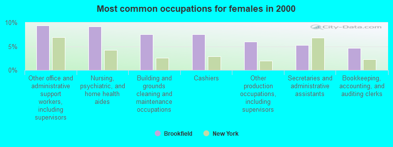
- Other office and administrative support workers, including supervisors (9.3%)
- Nursing, psychiatric, and home health aides (9.2%)
- Building and grounds cleaning and maintenance occupations (7.5%)
- Cashiers (7.5%)
- Other production occupations, including supervisors (6.0%)
- Secretaries and administrative assistants (5.2%)
- Bookkeeping, accounting, and auditing clerks (4.7%)
Average climate in Brookfield, New York
Based on data reported by over 4,000 weather stations


(lower is better)
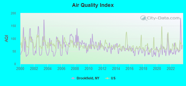
Air Quality Index (AQI) level in 2023 was 77.3. This is about average.
| City: | 77.3 |
| U.S.: | 72.6 |
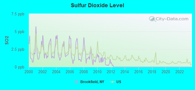
Sulfur Dioxide (SO2) [ppb] level in 2011 was 0.547. This is significantly better than average. Closest monitor was 21.3 miles away from the city center.
| City: | 0.547 |
| U.S.: | 1.515 |
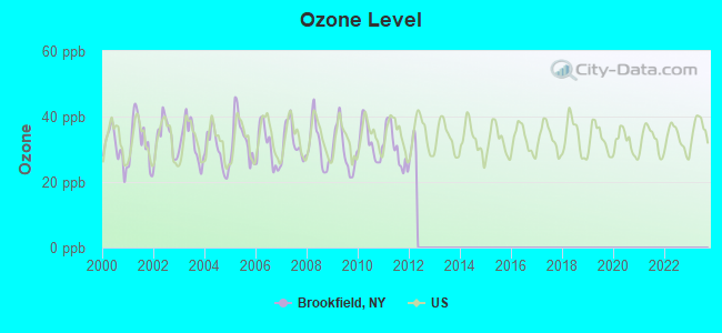
Ozone [ppb] level in 2011 was 30.6. This is about average. Closest monitor was 21.8 miles away from the city center.
| City: | 30.6 |
| U.S.: | 33.3 |
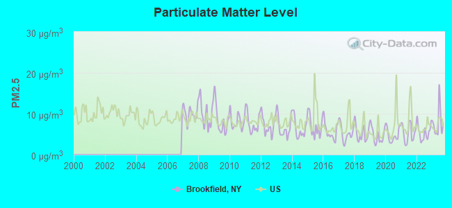
Particulate Matter (PM2.5) [µg/m3] level in 2023 was 7.86. This is about average. Closest monitor was 21.3 miles away from the city center.
| City: | 7.86 |
| U.S.: | 8.11 |
Tornado activity:
Brookfield-area historical tornado activity is slightly below New York state average. It is 70% smaller than the overall U.S. average.
On 7/10/1989, a category F4 (max. wind speeds 207-260 mph) tornado 41.4 miles away from the Brookfield town center injured 20 people and caused between $5,000,000 and $50,000,000 in damages.
On 5/31/1998, a category F3 (max. wind speeds 158-206 mph) tornado 22.7 miles away from the town center injured 3 people and caused $800,000 in damages.
Earthquake activity:
Brookfield-area historical earthquake activity is significantly above New York state average. It is 67% smaller than the overall U.S. average.On 10/7/1983 at 10:18:46, a magnitude 5.3 (5.1 MB, 5.3 LG, 5.1 ML, Class: Moderate, Intensity: VI - VII) earthquake occurred 94.1 miles away from Brookfield center
On 4/20/2002 at 10:50:47, a magnitude 5.3 (5.3 ML, Depth: 3.0 mi) earthquake occurred 144.0 miles away from the city center
On 4/20/2002 at 10:50:47, a magnitude 5.2 (5.2 MB, 4.2 MS, 5.2 MW, 5.0 MW) earthquake occurred 142.0 miles away from the city center
On 8/23/2011 at 17:51:04, a magnitude 5.8 (5.8 MW, Depth: 3.7 mi) earthquake occurred 365.0 miles away from the city center
On 6/17/1991 at 08:53:16, a magnitude 4.1 (4.0 MB, 4.0 LG, Depth: 3.1 mi, Class: Light, Intensity: IV - V) earthquake occurred 36.0 miles away from Brookfield center
On 9/25/1998 at 19:52:52, a magnitude 5.2 (4.8 MB, 4.3 MS, 5.2 LG, 4.5 MW, Depth: 3.1 mi) earthquake occurred 274.5 miles away from Brookfield center
Magnitude types: regional Lg-wave magnitude (LG), body-wave magnitude (MB), local magnitude (ML), surface-wave magnitude (MS), moment magnitude (MW)
Natural disasters:
The number of natural disasters in Madison County (21) is greater than the US average (15).Major Disasters (Presidential) Declared: 13
Emergencies Declared: 6
Causes of natural disasters: Storms: 11, Floods: 9, Hurricanes: 2, Snowstorms: 2, Tornadoes: 2, Winds: 2, Blizzard: 1, Heavy Rain: 1, Ice Storm: 1, Landslide: 1, Power Outage: 1, Tropical Storm: 1, Winter Storm: 1, Other: 2 (Note: some incidents may be assigned to more than one category).

Hospitals and medical centers near Brookfield:
Colleges/universities with over 2000 students nearest to Brookfield:
- Colgate University (about 10 miles; Hamilton, NY; Full-time enrollment: 3,094)
- Morrisville State College (about 15 miles; Morrisville, NY; FT enrollment: 2,823)
- Mohawk Valley Community College (about 20 miles; Utica, NY; FT enrollment: 5,693)
- Utica College (about 21 miles; Utica, NY; FT enrollment: 2,952)
- Herkimer County Community College (about 24 miles; Herkimer, NY; FT enrollment: 2,774)
- SUNY Oneonta (about 28 miles; Oneonta, NY; FT enrollment: 6,081)
- Le Moyne College (about 42 miles; Syracuse, NY; FT enrollment: 3,041)
Public high school in Brookfield:
- BROOKFIELD CENTRAL SCHOOL (Students: 249, Location: 1910 FAIRGROUND RD, Grades: PK-12)
Points of interest:
Notable locations in Brookfield: Rocky Top Acres (A), Five Corners (B), Marsh Corners (C), River Forks (D), Leonardsville Volunteer Fire Company (E). Display/hide their locations on the map
Church in Brookfield: First Baptist Church (A). Display/hide its location on the map
Cemeteries: Giles Cemetery (1), Welch Cemetery (2), North Brookfield Cemetery (3), Quaker Hill Cemetery (4), Brookfield Rural Cemetery (5), Leonardsville Cemetery (6), West Edmeston Cemetery (7). Display/hide their locations on the map
Lakes and swamps: Lost Pond (A), Snow Pond (B), York Pond (C), Barns Pond (D), Gorton Lake (E), Ninemile Swamp (F). Display/hide their locations on the map
Streams, rivers, and creeks: West Creek (A), Button Creek (B), Campbell Brook (C), Mill Creek (D). Display/hide their locations on the map
Drinking water stations with addresses in Brookfield and their reported violations in the past:
FLICKS TAVERN (Population served: 35, Groundwater):Past health violations:
- Treatment Technique (SWTR and GWR) - In MAY-2013, Contaminant: GROUNDWATER RULE. Follow-up actions: St Formal NOV issued (MAY-15-2013), St Compliance achieved (MAY-17-2013)
| This town: | 2.6 people |
| New York: | 2.6 people |
| This town: | 70.5% |
| Whole state: | 63.5% |
| This town: | 10.2% |
| Whole state: | 6.8% |
Likely homosexual households (counted as self-reported same-sex unmarried-partner households)
- Lesbian couples: 0.9% of all households
- Gay men: 0.7% of all households
| This town: | 13.9% |
| Whole state: | 14.6% |
| This town: | 5.9% |
| Whole state: | 7.4% |
For population 15 years and over in Brookfield:
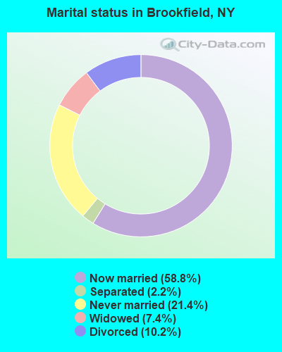
- Never married: 21.4%
- Now married: 58.8%
- Separated: 2.2%
- Widowed: 7.4%
- Divorced: 10.2%
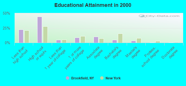
For population 25 years and over in Brookfield:
- High school or higher: 77.5%
- Bachelor's degree or higher: 9.2%
- Graduate or professional degree: 4.2%
- Unemployed: 5.0%
- Mean travel time to work (commute): 28.8 minutes
| Here: | 10.0 |
| New York average: | 14.2 |
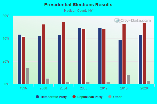
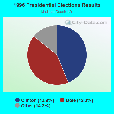
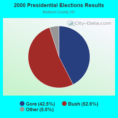
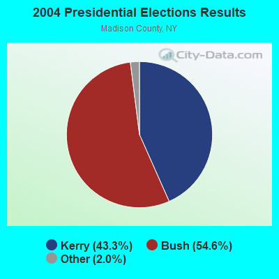
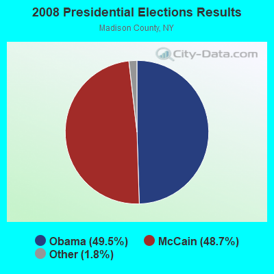
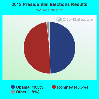
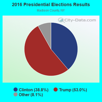
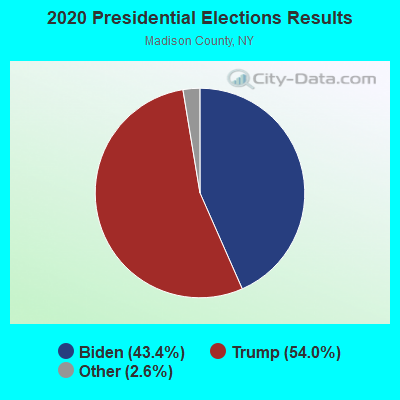
Graphs represent county-level data. Detailed 2008 Election Results
Religion statistics for Brookfield, NY (based on Madison County data)
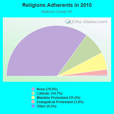
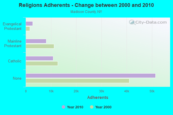
| Religion | Adherents | Congregations |
|---|---|---|
| Catholic | 10,810 | 9 |
| Mainline Protestant | 8,060 | 45 |
| Evangelical Protestant | 2,780 | 28 |
| Other | 358 | 6 |
| None | 51,434 | - |
Food Environment Statistics:
| Here: | 2.15 / 10,000 pop. |
| State: | 4.13 / 10,000 pop. |
| Madison County: | 0.14 / 10,000 pop. |
| New York: | 0.06 / 10,000 pop. |
| This county: | 0.57 / 10,000 pop. |
| New York: | 0.92 / 10,000 pop. |
| Here: | 2.72 / 10,000 pop. |
| New York: | 1.68 / 10,000 pop. |
| This county: | 8.30 / 10,000 pop. |
| New York: | 8.82 / 10,000 pop. |
| This county: | 7.4% |
| New York: | 8.2% |
| Madison County: | 26.6% |
| New York: | 23.8% |
| Madison County: | 15.9% |
| State: | 15.6% |
Strongest AM radio stations in Brookfield:
- WGY (810 AM; 50 kW; SCHENECTADY, NY; Owner: CLEAR CHANNEL BROADCASTING LICENSES, INC.)
- WTLB (1310 AM; 5 kW; UTICA, NY; Owner: GALAXY COMMUNICATIONS, L.P.)
- WIBX (950 AM; 5 kW; UTICA, NY; Owner: REGENT LICENSEE OF UTICA/ROME, INC.)
- WRUN (1150 AM; 5 kW; UTICA, NY)
- WPTR (1540 AM; 50 kW; ALBANY, NY; Owner: KIMTRON, INC.)
- WSYR (570 AM; 5 kW; SYRACUSE, NY; Owner: CLEAR CHANNEL BROADCASTING LICENSES, INC.)
- WNNZ (640 AM; 50 kW; WESTFIELD, MA; Owner: CLEAR CHANNEL BROADCASTING LICENSES, INC.)
- WHEN (620 AM; 5 kW; SYRACUSE, NY; Owner: CLEAR CHANNEL BROADCASTING LICENSES, INC.)
- WMCA (570 AM; 50 kW; NEW YORK, NY; Owner: SALEM MEDIA OF NEW YORK, LLC)
- WFAN (660 AM; 50 kW; NEW YORK, NY; Owner: INFINITY BROADCASTING OPERATIONS, INC.)
- WHAM (1180 AM; 50 kW; ROCHESTER, NY; Owner: CITICASTERS LICENSES, L.P.)
- WOR (710 AM; 50 kW; NEW YORK, NY; Owner: BUCKLEY BROADCASTING CORPORATION)
- WABC (770 AM; 50 kW; NEW YORK, NY; Owner: WABC-AM RADIO, INC.)
Strongest FM radio stations in Brookfield:
- WSKS (97.9 FM; WHITESBORO, NY; Owner: CLEAR CHANNEL BROADCASTING LICENSES, INC.)
- WRBY (102.5 FM; ROME, NY; Owner: CLEAR CHANNEL BROADCASTING LICENSES, INC.)
- WKXZ (93.9 FM; NORWICH, NY; Owner: BANJO COMMUNICATIONS GROUP, INC)
- WKVU (100.7 FM; UTICA, NY; Owner: EDUCATIONAL MEDIA FOUNDATION)
- WOUR (96.9 FM; UTICA, NY; Owner: CLEAR CHANNEL BROADCASTING LICENSES, INC.)
- WMCR-FM (106.3 FM; ONEIDA, NY; Owner: WARREN BROADCASTING CO. INC.)
- WUNY (89.5 FM; UTICA, NY; Owner: PUBLIC BC COUNCIL OF CENTRAL NY, INC)
- WFRG-FM (104.3 FM; UTICA, NY; Owner: REGENT LICENSEE OF UTICA/ROME, INC.)
- WBKT (95.3 FM; NORWICH, NY; Owner: BANJO COMMUNICATIONS GROUP, INC)
- WWDG (105.1 FM; DERUYTER, NY; Owner: CLEAR CHANNEL BROADCASTING LICENSES, INC.)
- WJIV (101.9 FM; CHERRY VALLEY, NY; Owner: CHRISTIAN BROADCASTING SYSTEM, LTD.)
- WLZW (98.7 FM; UTICA, NY; Owner: REGENT LICENSEE OF UTICA/ROME, INC.)
- W257BE (99.3 FM; HAMILTON, NY; Owner: BANJO COMMUNICATIONS GROUP, INC)
- WGKR (105.3 FM; GRAND GORGE, NY; Owner: SOUND OF LIFE, INC.)
- WBGK (99.7 FM; NEWPORT VILLAGE, NY; Owner: ROSER COMMUNICATIONS NETWORK, INC.)
- WKLL (94.9 FM; FRANKFORT, NY; Owner: GALAXY COMMUNICATIONS, L.P.)
- WRCU-FM (90.1 FM; HAMILTON, NY; Owner: COLGATE UNIVERSITY)
- WODZ-FM (96.1 FM; ROME, NY; Owner: REGENT LICENSEE OF UTICA/ROME, INC.)
- WRCK (107.3 FM; UTICA, NY; Owner: GALAXY COMMUNICATIONS, L.P.)
- WCNY-FM (91.3 FM; SYRACUSE, NY; Owner: THE PUB. B/C COUNC. OF CEN. NY, INC.)
TV broadcast stations around Brookfield:
- WFXV (Channel 33; UTICA, NY; Owner: QUORUM OF UTICA LICENSE, LLC)
- WKTV (Channel 2; UTICA, NY; Owner: SMITH TELEVISION OF NEW YORK LICENSE HOLDINGS, INC.)
- WIXT-TV (Channel 9; SYRACUSE, NY; Owner: CENTRAL NY NEWS, INC.)
- WCNY-TV (Channel 24; SYRACUSE, NY; Owner: PUBLIC BROADCASTING COUNCIL OF CENTRAL NEW YORK)
- WSTM-TV (Channel 3; SYRACUSE, NY; Owner: WSTM LICENSE SUBSIDIARY, INC.)
- WNYS-TV (Channel 43; SYRACUSE, NY; Owner: RKM MEDIA, INC.)
- W59AU (Channel 59; UTICA, NY; Owner: PUBLIC B/CING.COUNCIL,CENTRAL N. Y.)
- W29BJ (Channel 29; BURLINGTON, NY; Owner: KEVIN O'KANE)
- WSYT (Channel 68; SYRACUSE, NY; Owner: WSYT LICENSEE L.P.)
- WUTR (Channel 20; UTICA, NY; Owner: CENTRAL NY NEWS, INC.)
- National Bridge Inventory (NBI) Statistics
- 9Number of bridges
- 52ft / 15.6mTotal length
- $4,970,000Total costs
- 4,801Total average daily traffic
- 686Total average daily truck traffic
- 6,022Total future (year 2036) average daily traffic
FCC Registered Cell Phone Towers:
1- 1732 Dugway Rd (Lat: 42.804444 Lon: -75.304306), Type: Pole, Structure height: 59.1 m, Overall height: 60.7 m, Call Sign: KNKA294
Assigned Frequencies: 869.040 MHz, 869.040 MHz, 869.040 MHz, 824.040 MHz, 824.040 MHz, 824.040 MHz, 890.010 MHz, 890.010 MHz, 890.010 MHz, 845.010 MHz, 845.010 MHz, 845.010 MHzGrant Date: 09/01/2015, Expiration Date: 10/01/2025, Certifier: David C JatlowRegistrant: At&t Services, Inc., 208 S Akard St, 20f, Dallas, TX 75202, Phone: (855) 699-7073, Fax: (214) 746-6410, Email:
FCC Registered Antenna Towers:
2- Paul Hartnett, 1659 Quaker Hill Road (Lat: 42.794972 Lon: -75.392278), Type: 68.6, Overall height: 64 m, Registrant: County Of Madison, Wamps-ville, Phone: (315) 366-2757
- Chick Langone, 1659 Quaker Hill Road (Lat: 42.794972 Lon: -75.392278), Type: 68.6, Overall height: 64 m, Registrant: County Of Madison, Wamps-ville, Phone: (315) 366-2757
FCC Registered Broadcast Land Mobile Towers:
5- Turnpike Rd (Lat: 42.821750 Lon: -75.293500), Structure height: 30 m, Call Sign: WPAF751, Licensee ID: L00003879,
Assigned Frequencies: 460.625 MHz, Grant Date: 07/21/2022, Expiration Date: 08/04/2032, Registrant: Madison County 911, Wampsville, NY 13163, Phone: (315) 366-2757, Fax: (315) 366-2593, Email:
- Gorton Hill Off Keith Rd (Lat: 42.851194 Lon: -75.355167), Type: Pole, Structure height: 30 m, Call Sign: KEO306,
Assigned Frequencies: 158.745 MHz, 158.745 MHz, Grant Date: 09/13/2012, Expiration Date: 12/02/2022, Cancellation Date: 04/22/2023, Registrant: Business Radio Licensing, 26941 Cabot Road #134, Laguna Hills, CA 92653, Phone: (949) 348-8510, Fax: (949) 348-8514, Email:
- Skaneatles Turnpike & Miner Rd (Lat: 42.821750 Lon: -75.293500), Call Sign: KEM525, Licensee ID: L00003879,
Assigned Frequencies: 159.240 MHz, Grant Date: 03/01/2014, Expiration Date: 03/09/2024, Cancellation Date: 11/29/2023, Registrant: County Of Madison, 138 N Court St, Bldg 7, Wampsville, NY 13163, Phone: (315) 366-2756, Email:
- Beaver Hill, Skaneateles Tpke(Ch 80) (Lat: 42.821750 Lon: -75.293500), Type: Tower, Structure height: 25.5 m, Overall height: 30.5 m, Call Sign: WPUQ258, Licensee ID: L00003879,
Assigned Frequencies: 460.125 MHz, 460.400 MHz, 460.450 MHz, Grant Date: 03/07/2022, Expiration Date: 04/11/2032, Certifier: Paul Harnett, Registrant: County Of Madison, 138 N Court St, Wampsville, NY 13163, Phone: (315) 366-2757, Fax: (315) 366-2593, Email:
- QUAKER HILL (QKR1), 1659 Quaker Hill Road (Lat: 42.794972 Lon: -75.392278), Type: Tower, Structure height: 64 m, Overall height: 68.6 m, Call Sign: WQLN443,
Assigned Frequencies: 453.162 MHz, 460.062 MHz, Grant Date: 03/12/2020, Expiration Date: 03/15/2030, Certifier: Paul Hartnett, Registrant: Vogel Consulting Group, 115 Deer Trail, Ramsey, NJ 07446, Phone: (201) 327-8083, Fax: (201) 327-0846, Email:
FCC Registered Microwave Towers:
3- QKR 1, 1659 Quaker Hill Road (Lat: 42.794972 Lon: -75.392278), Type: Tower, Structure height: 64 m, Overall height: 68.6 m, Call Sign: WQNH527,
Assigned Frequencies: 6286.19 MHz, 6256.54 MHz, 6286.19 MHz, 6256.54 MHz, 6286.19 MHz, 6256.54 MHz, 6286.19 MHz, 6256.54 MHz, 6286.19 MHz, 6256.54 MHz... (+6 more), Grant Date: 12/23/2020, Expiration Date: 02/07/2031, Certifier: Paul Hartnett, Registrant: Langone & Associates, 87 Emerald Court, Tewksbury, MA 01876, Phone: (978) 851-0198, Fax: (978) 851-0975
- WEST BROOKFI, 9438 Skaneateles Turnpike Road (Lat: 42.808583 Lon: -75.386889), Type: Ltower, Structure height: 59.4 m, Overall height: 60.7 m, Call Sign: WQYJ559, Licensee ID: L00299631,
Assigned Frequencies: 11325.0 MHz, Grant Date: 10/18/2016, Expiration Date: 10/18/2026, Certifier: Scott Basista, Registrant: Transwave Communication Systems, Inc., 9020 Wehrle Drive, Clarence, NY 14031, Phone: (716) 626-9020, Fax: (716) 626-4991, Email:
- STATION, Skaneateles Turnpike (Lat: 42.821722 Lon: -75.293472), Overall height: 30.5 m, Call Sign: WHH727,
Assigned Frequencies: 2134.00 MHz, Grant Date: 01/11/2008, Expiration Date: 01/19/2018, Cancellation Date: 05/14/2013, Phone: (603) 672-5040
FCC Registered Amateur Radio Licenses:
2- Call Sign: KA8LYN, Licensee ID: L01370383, Grant Date: 02/20/2008, Expiration Date: 02/25/2018, Cancellation Date: 02/26/2020, Registrant: Lucinda J Gregory, 10498 Main St, Brookfield, NY 13314
- Call Sign: N8DCD, Licensee ID: L01370378, Grant Date: 02/20/2008, Expiration Date: 02/25/2018, Cancellation Date: 02/26/2020, Registrant: Terry J Pierce Sr, 10498 Main St, Brookfield, NY 13314
| Most common first names in Brookfield, NY among deceased individuals | ||
| Name | Count | Lived (average) |
|---|---|---|
| George | 3 | 79.0 years |
| Francis | 3 | 65.3 years |
| Charles | 3 | 70.0 years |
| John | 3 | 65.7 years |
| Mary | 3 | 74.7 years |
| Robert | 3 | 54.4 years |
| Betty | 2 | 76.5 years |
| Albert | 2 | 67.0 years |
| Frank | 2 | 84.6 years |
| Ethel | 2 | 80.0 years |
| Most common last names in Brookfield, NY among deceased individuals | ||
| Last name | Count | Lived (average) |
|---|---|---|
| Rogers | 6 | 84.5 years |
| Johnson | 5 | 73.0 years |
| Chesebro | 5 | 74.4 years |
| Palmer | 5 | 69.2 years |
| Williams | 3 | 70.7 years |
| Davis | 3 | 79.4 years |
| Dibble | 3 | 77.7 years |
| Spooner | 3 | 78.7 years |
| Becraft | 2 | 75.0 years |
| Grantier | 2 | 74.5 years |
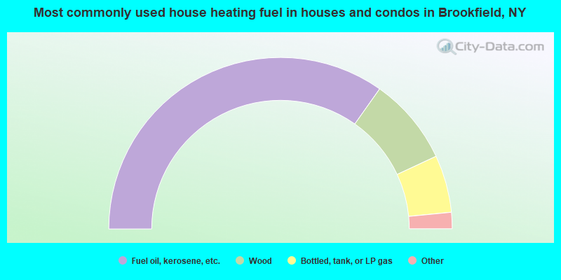
- 69.6%Fuel oil, kerosene, etc.
- 16.5%Wood
- 10.8%Bottled, tank, or LP gas
- 0.9%Utility gas
- 0.9%Electricity
- 0.8%Other fuel
- 0.4%No fuel used
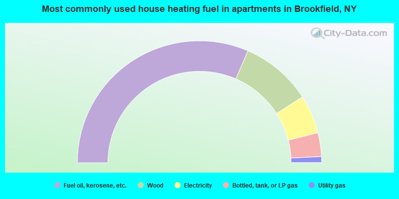
- 63.0%Fuel oil, kerosene, etc.
- 18.9%Wood
- 10.2%Electricity
- 6.3%Bottled, tank, or LP gas
- 1.6%Utility gas
Brookfield compared to New York state average:
- Median house value significantly below state average.
- Unemployed percentage significantly below state average.
- Black race population percentage significantly below state average.
- Hispanic race population percentage significantly below state average.
- Foreign-born population percentage significantly below state average.
- Renting percentage significantly below state average.
- Length of stay since moving in significantly above state average.
- Number of rooms per house significantly below state average.
- House age significantly below state average.
- Number of college students below state average.
- Percentage of population with a bachelor's degree or higher significantly below state average.