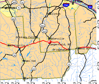
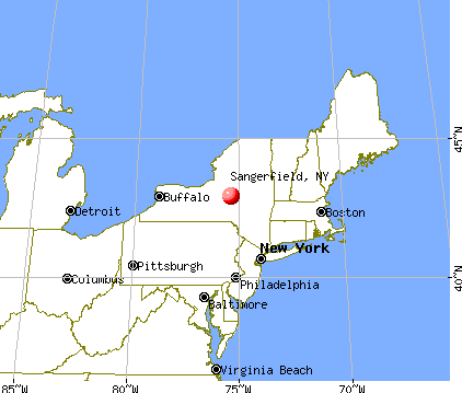
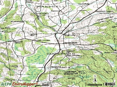
Sangerfield, New York
Submit your own pictures of this town and show them to the world
- OSM Map
- General Map
- Google Map
- MSN Map
Population change since 2000: -1.9%
 |
| Males: 1,256 | |
| Females: 1,305 |
| Median resident age: | 41.9 years |
| New York median age: | 40.7 years |
Zip codes: 13480.
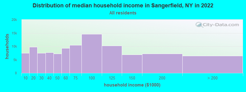
| Sangerfield: | $68,534 |
| NY: | $79,557 |
Estimated per capita income in 2022: $32,579 (it was $17,068 in 2000)
Sangerfield town income, earnings, and wages data
Estimated median house or condo value in 2022: $174,322 (it was $76,000 in 2000)
| Sangerfield: | $174,322 |
| NY: | $400,400 |
Mean prices in 2022: all housing units: $197,131; detached houses: $205,775; townhouses or other attached units: $204,104; in 2-unit structures: $275,728; in 3-to-4-unit structures: $126,003; in 5-or-more-unit structures: $544,387; mobile homes: $61,833
Detailed information about poverty and poor residents in Sangerfield, NY


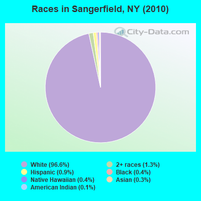
- 2,47396.6%White alone
- 341.3%Two or more races
- 220.9%Hispanic
- 100.4%Black alone
- 100.4%Native Hawaiian and Other
Pacific Islander alone - 70.3%Asian alone
- 30.1%American Indian alone
- 20.08%Other race alone
Races in Sangerfield detailed stats: ancestries, foreign born residents, place of birth
 Recent articles from our blog. Our writers, many of them Ph.D. graduates or candidates, create easy-to-read articles on a wide variety of topics.

 | Syracuse Chat thread (6339 replies) |
Latest news from Sangerfield, NY collected exclusively by city-data.com from local newspapers, TV, and radio stations
Ancestries: English (21.7%), Irish (19.4%), German (17.7%), Polish (9.3%), French (7.8%), Italian (6.2%).
Current Local Time: EST time zone
Elevation: 1248 feet
Land area: 30.8 square miles.
Population density: 83 people per square mile (very low).
50 residents are foreign born
| This town: | 1.9% |
| New York: | 20.4% |
| Sangerfield town: | 2.5% ($1,863) |
| New York: | 1.9% ($2,847) |
Nearest city with pop. 50,000+: Utica, NY  (14.7 miles , pop. 60,651).
Nearest city with pop. 200,000+: Rochester, NY (114.1 miles , pop. 219,773).
Nearest city with pop. 1,000,000+: Bronx, NY (162.7 miles , pop. 1,332,650).
Nearest cities:
), ), ), ), ), ), Latitude: 42.91 N, Longitude: 75.38 W
Area code commonly used in this area: 315

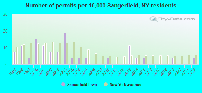
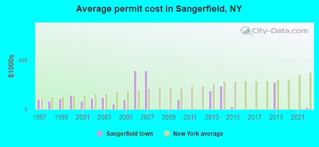
Single-family new house construction building permits:
- 2022: 1 building, cost: $20,000
- 2019: 1 building, cost: $282,200
- 2015: 1 building, cost: $30,000
- 2014: 1 building, cost: $241,400
- 2013: 3 buildings, average cost: $193,300
- 2010: 1 building, cost: $98,000
- 2007: 1 building, cost: $395,000
- 2006: 1 building, cost: $395,000
- 2005: 1 building, cost: $100,000
- 2004: 5 buildings, average cost: $56,000
- 2003: 2 buildings, average cost: $125,000
- 2002: 2 buildings, average cost: $115,000
- 2001: 3 buildings, average cost: $85,000
- 2000: 4 buildings, average cost: $148,300
- 1999: 1 building, cost: $110,000
- 1998: 3 buildings, average cost: $83,000
- 1997: 2 buildings, average cost: $104,000
| Here: | 4.2% |
| New York: | 4.4% |

- Educational services (15.0%)
- Health care (12.6%)
- Finance & insurance (6.1%)
- Construction (5.3%)
- Public administration (5.1%)
- Accommodation & food services (4.8%)
- Professional, scientific, technical services (3.8%)
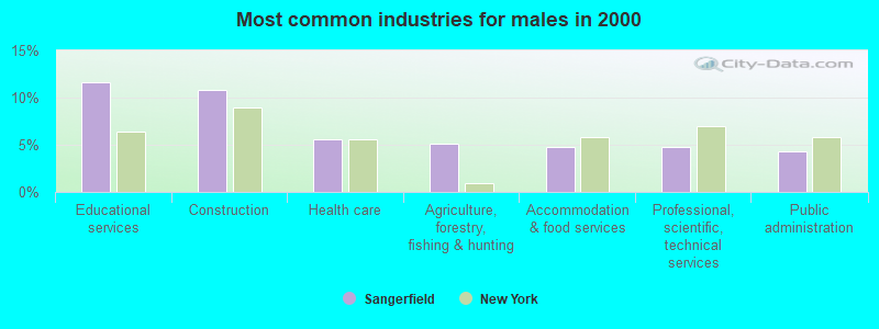
- Educational services (11.6%)
- Construction (10.8%)
- Health care (5.6%)
- Agriculture, forestry, fishing & hunting (5.1%)
- Accommodation & food services (4.8%)
- Professional, scientific, technical services (4.8%)
- Public administration (4.3%)
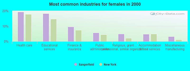
- Health care (19.4%)
- Educational services (18.3%)
- Finance & insurance (9.6%)
- Public administration (5.8%)
- Religious, grantmaking, civic, professional, similar organizations (5.0%)
- Accommodation & food services (4.8%)
- Miscellaneous manufacturing (3.2%)
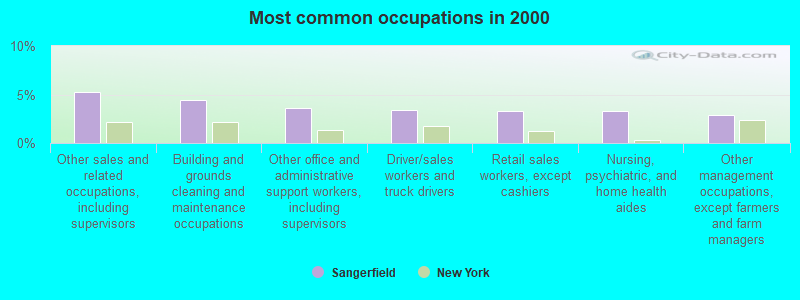
- Other sales and related occupations, including supervisors (5.2%)
- Building and grounds cleaning and maintenance occupations (4.5%)
- Other office and administrative support workers, including supervisors (3.6%)
- Driver/sales workers and truck drivers (3.4%)
- Retail sales workers, except cashiers (3.3%)
- Nursing, psychiatric, and home health aides (3.3%)
- Other management occupations, except farmers and farm managers (2.9%)
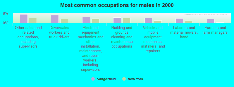
- Other sales and related occupations, including supervisors (7.3%)
- Driver/sales workers and truck drivers (6.6%)
- Electrical equipment mechanics and other installation, maintenance, and repair workers, including supervisors (5.1%)
- Building and grounds cleaning and maintenance occupations (4.6%)
- Vehicle and mobile equipment mechanics, installers, and repairers (4.5%)
- Laborers and material movers, hand (4.0%)
- Farmers and farm managers (3.5%)
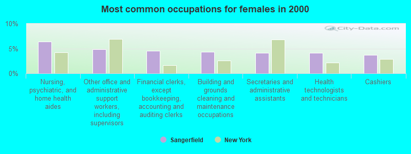
- Nursing, psychiatric, and home health aides (6.4%)
- Other office and administrative support workers, including supervisors (4.8%)
- Financial clerks, except bookkeeping, accounting and auditing clerks (4.5%)
- Building and grounds cleaning and maintenance occupations (4.3%)
- Secretaries and administrative assistants (4.2%)
- Health technologists and technicians (4.2%)
- Cashiers (3.7%)
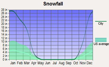
Average climate in Sangerfield, New York
Based on data reported by over 4,000 weather stations


(lower is better)
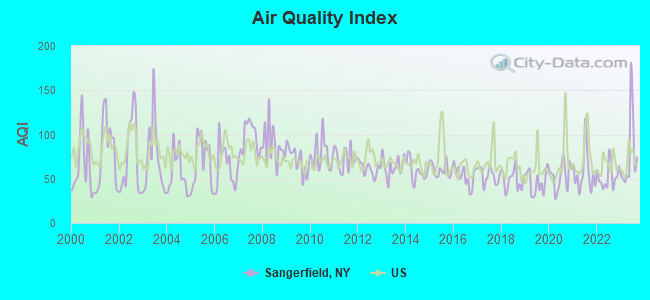
Air Quality Index (AQI) level in 2023 was 77.3. This is about average.
| City: | 77.3 |
| U.S.: | 72.6 |
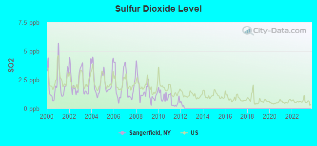
Sulfur Dioxide (SO2) [ppb] level in 2011 was 0.547. This is significantly better than average. Closest monitor was 15.0 miles away from the city center.
| City: | 0.547 |
| U.S.: | 1.515 |
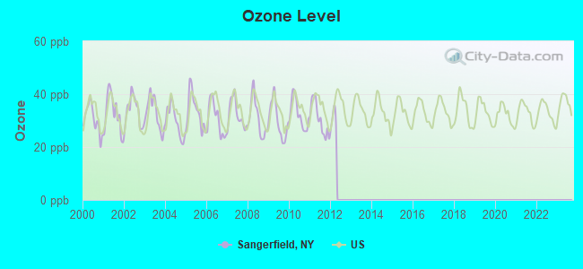
Ozone [ppb] level in 2011 was 30.6. This is about average. Closest monitor was 15.9 miles away from the city center.
| City: | 30.6 |
| U.S.: | 33.3 |
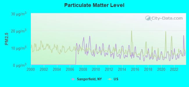
Particulate Matter (PM2.5) [µg/m3] level in 2023 was 7.86. This is about average. Closest monitor was 15.0 miles away from the city center.
| City: | 7.86 |
| U.S.: | 8.11 |
Tornado activity:
Sangerfield-area historical tornado activity is slightly below New York state average. It is 72% smaller than the overall U.S. average.
On 7/10/1989, a category F4 (max. wind speeds 207-260 mph) tornado 43.5 miles away from the Sangerfield town center injured 20 people and caused between $5,000,000 and $50,000,000 in damages.
On 5/31/1998, a category F3 (max. wind speeds 158-206 mph) tornado 30.1 miles away from the town center injured 3 people and caused $800,000 in damages.
Earthquake activity:
Sangerfield-area historical earthquake activity is significantly above New York state average. It is 67% smaller than the overall U.S. average.On 10/7/1983 at 10:18:46, a magnitude 5.3 (5.1 MB, 5.3 LG, 5.1 ML, Class: Moderate, Intensity: VI - VII) earthquake occurred 88.8 miles away from the city center
On 4/20/2002 at 10:50:47, a magnitude 5.3 (5.3 ML, Depth: 3.0 mi) earthquake occurred 138.9 miles away from the city center
On 4/20/2002 at 10:50:47, a magnitude 5.2 (5.2 MB, 4.2 MS, 5.2 MW, 5.0 MW) earthquake occurred 136.9 miles away from Sangerfield center
On 6/17/1991 at 08:53:16, a magnitude 4.1 (4.0 MB, 4.0 LG, Depth: 3.1 mi, Class: Light, Intensity: IV - V) earthquake occurred 40.7 miles away from the city center
On 8/23/2011 at 17:51:04, a magnitude 5.8 (5.8 MW, Depth: 3.7 mi) earthquake occurred 371.3 miles away from the city center
On 9/25/1998 at 19:52:52, a magnitude 5.2 (4.8 MB, 4.3 MS, 5.2 LG, 4.5 MW, Depth: 3.1 mi) earthquake occurred 275.1 miles away from Sangerfield center
Magnitude types: regional Lg-wave magnitude (LG), body-wave magnitude (MB), local magnitude (ML), surface-wave magnitude (MS), moment magnitude (MW)
Natural disasters:
The number of natural disasters in Oneida County (23) is greater than the US average (15).Major Disasters (Presidential) Declared: 12
Emergencies Declared: 9
Causes of natural disasters: Storms: 9, Floods: 7, Tropical Storms: 3, Hurricanes: 2, Snows: 2, Snowstorms: 2, Winds: 2, Blizzard: 1, Ice Storm: 1, Power Outage: 1, Tornado: 1, Winter Storm: 1, Other: 2 (Note: some incidents may be assigned to more than one category).
Hospitals and medical centers near Sangerfield:
- HARDING NURSING HOME (Nursing Home, about 2 miles away; WATERVILLE, NY)
- KATHERINE LUTHER RESIDENTIAL HLTH CARE AND REHAB (Nursing Home, about 10 miles away; CLINTON, NY)
- FAXTON ST LUKE'S HEALTHCARE - HAMILTON (Dialysis Facility, about 11 miles away; HAMILTON, NY)
- COMMUNITY MEMORIAL HOSPITAL, INC Acute Care Hospitals (about 11 miles away; HAMILTON, NY)
- HOSPICE AND PALLIATIVE CARE INC NEW HARTFORD (Hospital, about 12 miles away; NEW HARTFORD, NY)
- PRESBYTERIAN HOME FOR CENTRAL NEW YORK INC (Nursing Home, about 12 miles away; NEW HARTFORD, NY)
- CHARLES T SITRIN HEALTH CARE S N F (Nursing Home, about 13 miles away; NEW HARTFORD, NY)
Amtrak station near Sangerfield:
Colleges/universities with over 2000 students nearest to Sangerfield:
- Colgate University (about 11 miles; Hamilton, NY; Full-time enrollment: 3,094)
- Morrisville State College (about 12 miles; Morrisville, NY; FT enrollment: 2,823)
- Utica College (about 14 miles; Utica, NY; FT enrollment: 2,952)
- Mohawk Valley Community College (about 15 miles; Utica, NY; FT enrollment: 5,693)
- Herkimer County Community College (about 21 miles; Herkimer, NY; FT enrollment: 2,774)
- SUNY Oneonta (about 35 miles; Oneonta, NY; FT enrollment: 6,081)
- Le Moyne College (about 37 miles; Syracuse, NY; FT enrollment: 3,041)
Points of interest:
Notable locations in Sangerfield: Alcott Greenhouses (A), Stockwell Farms (B), Waterville Municipal Building (C), Harding Nursing Home (D), Waterville Public Library (E), Waterville Volunteer Fire Department Engine House (F). Display/hide their locations on the map
Churches in Sangerfield include: Waterville Baptist Church (A), Saint Bernard's Church (B), Grace Episcopal Church (C), Saint Bernard's Roman Catholic Church (D), Grace Episcopal Church (E), First Baptist Church (F), First Presbyterian Church (G). Display/hide their locations on the map
Cemeteries: Saint Bernards Cemetery (1), Waterville Village Cemetery (2), Tarrytown Cemetery (3). Display/hide their locations on the map
Lake: Bailey Lake (A). Display/hide its location on the map
| This town: | 2.5 people |
| New York: | 2.6 people |
| This town: | 66.2% |
| Whole state: | 63.5% |
| This town: | 9.8% |
| Whole state: | 6.8% |
Likely homosexual households (counted as self-reported same-sex unmarried-partner households)
- Lesbian couples: 0.2% of all households
- Gay men: 0.6% of all households
| This town: | 9.7% |
| Whole state: | 14.6% |
| This town: | 4.7% |
| Whole state: | 7.4% |
91 people in nursing homes in 2000
For population 15 years and over in Sangerfield:
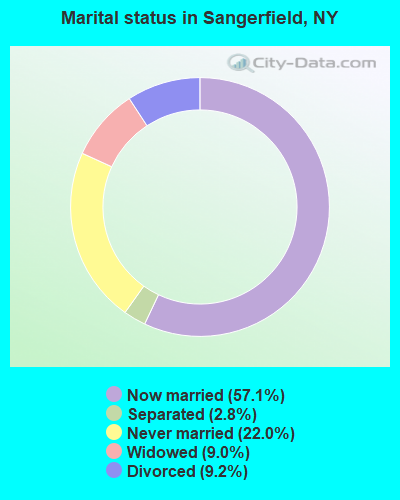
- Never married: 22.0%
- Now married: 57.1%
- Separated: 2.8%
- Widowed: 9.0%
- Divorced: 9.2%
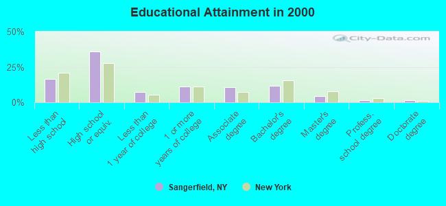
For population 25 years and over in Sangerfield:
- High school or higher: 83.5%
- Bachelor's degree or higher: 18.4%
- Graduate or professional degree: 6.7%
- Unemployed: 4.8%
- Mean travel time to work (commute): 25.1 minutes
| Here: | 10.4 |
| New York average: | 14.2 |
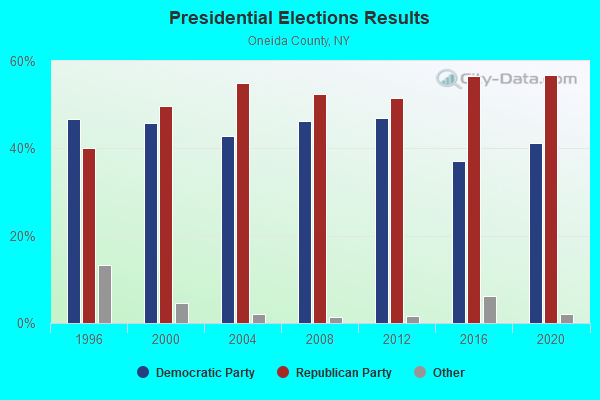
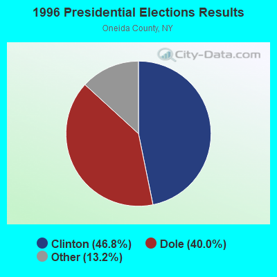
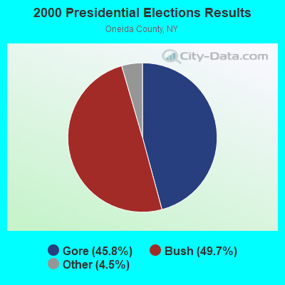
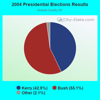
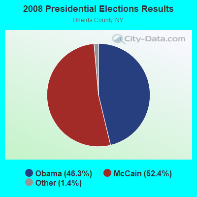
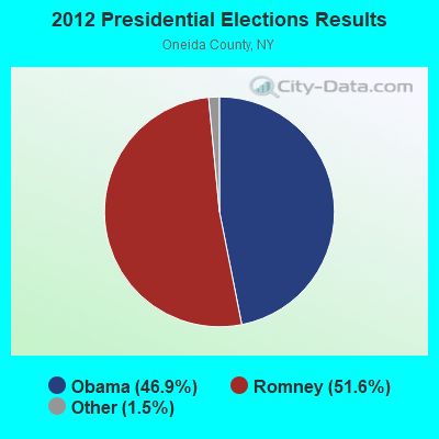
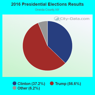
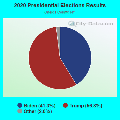
Graphs represent county-level data. Detailed 2008 Election Results
Religion statistics for Sangerfield, NY (based on Oneida County data)
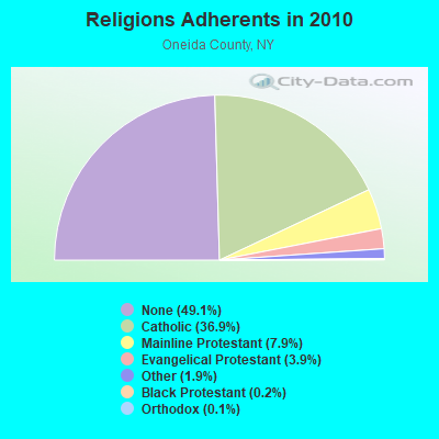
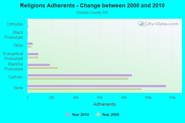
| Religion | Adherents | Congregations |
|---|---|---|
| Catholic | 86,750 | 51 |
| Mainline Protestant | 18,610 | 95 |
| Evangelical Protestant | 9,119 | 75 |
| Other | 4,416 | 16 |
| Black Protestant | 504 | 4 |
| Orthodox | 270 | 3 |
| None | 115,209 | - |
Food Environment Statistics:
| Oneida County: | 2.12 / 10,000 pop. |
| New York: | 4.13 / 10,000 pop. |
| Here: | 0.13 / 10,000 pop. |
| New York: | 0.06 / 10,000 pop. |
| Oneida County: | 0.47 / 10,000 pop. |
| New York: | 0.92 / 10,000 pop. |
| Oneida County: | 3.24 / 10,000 pop. |
| State: | 1.68 / 10,000 pop. |
| This county: | 8.85 / 10,000 pop. |
| New York: | 8.82 / 10,000 pop. |
| Oneida County: | 8.8% |
| New York: | 8.2% |
| Here: | 24.4% |
| State: | 23.8% |
| This county: | 15.0% |
| New York: | 15.6% |
Strongest AM radio stations in Sangerfield:
- WTLB (1310 AM; 5 kW; UTICA, NY; Owner: GALAXY COMMUNICATIONS, L.P.)
- WIBX (950 AM; 5 kW; UTICA, NY; Owner: REGENT LICENSEE OF UTICA/ROME, INC.)
- WRUN (1150 AM; 5 kW; UTICA, NY)
- WGY (810 AM; 50 kW; SCHENECTADY, NY; Owner: CLEAR CHANNEL BROADCASTING LICENSES, INC.)
- WPTR (1540 AM; 50 kW; ALBANY, NY; Owner: KIMTRON, INC.)
- WSYR (570 AM; 5 kW; SYRACUSE, NY; Owner: CLEAR CHANNEL BROADCASTING LICENSES, INC.)
- WHEN (620 AM; 5 kW; SYRACUSE, NY; Owner: CLEAR CHANNEL BROADCASTING LICENSES, INC.)
- WADR (1480 AM; 5 kW; REMSEN, NY; Owner: CLEAR CHANNEL BROADCASTING LICENSES, INC.)
- WNNZ (640 AM; 50 kW; WESTFIELD, MA; Owner: CLEAR CHANNEL BROADCASTING LICENSES, INC.)
- WNSS (1260 AM; 5 kW; SYRACUSE, NY; Owner: CITADEL BROADCASTING COMPANY)
- WMCA (570 AM; 50 kW; NEW YORK, NY; Owner: SALEM MEDIA OF NEW YORK, LLC)
- WHAM (1180 AM; 50 kW; ROCHESTER, NY; Owner: CITICASTERS LICENSES, L.P.)
- WUTQ (1550 AM; 1 kW; UTICA, NY)
Strongest FM radio stations in Sangerfield:
- WSKS (97.9 FM; WHITESBORO, NY; Owner: CLEAR CHANNEL BROADCASTING LICENSES, INC.)
- WRBY (102.5 FM; ROME, NY; Owner: CLEAR CHANNEL BROADCASTING LICENSES, INC.)
- WFRG-FM (104.3 FM; UTICA, NY; Owner: REGENT LICENSEE OF UTICA/ROME, INC.)
- WKVU (100.7 FM; UTICA, NY; Owner: EDUCATIONAL MEDIA FOUNDATION)
- WMCR-FM (106.3 FM; ONEIDA, NY; Owner: WARREN BROADCASTING CO. INC.)
- WOUR (96.9 FM; UTICA, NY; Owner: CLEAR CHANNEL BROADCASTING LICENSES, INC.)
- WUNY (89.5 FM; UTICA, NY; Owner: PUBLIC BC COUNCIL OF CENTRAL NY, INC)
- WLZW (98.7 FM; UTICA, NY; Owner: REGENT LICENSEE OF UTICA/ROME, INC.)
- WWDG (105.1 FM; DERUYTER, NY; Owner: CLEAR CHANNEL BROADCASTING LICENSES, INC.)
- WKLL (94.9 FM; FRANKFORT, NY; Owner: GALAXY COMMUNICATIONS, L.P.)
- WODZ-FM (96.1 FM; ROME, NY; Owner: REGENT LICENSEE OF UTICA/ROME, INC.)
- WBGK (99.7 FM; NEWPORT VILLAGE, NY; Owner: ROSER COMMUNICATIONS NETWORK, INC.)
- WRCK (107.3 FM; UTICA, NY; Owner: GALAXY COMMUNICATIONS, L.P.)
- WJIV (101.9 FM; CHERRY VALLEY, NY; Owner: CHRISTIAN BROADCASTING SYSTEM, LTD.)
- W257BE (99.3 FM; HAMILTON, NY; Owner: BANJO COMMUNICATIONS GROUP, INC)
- WUCL (93.5 FM; REMSEN, NY; Owner: CLEAR CHANNEL BROADCASTING LICENSES, INC.)
- WKXZ (93.9 FM; NORWICH, NY; Owner: BANJO COMMUNICATIONS GROUP, INC)
- WBKT (95.3 FM; NORWICH, NY; Owner: BANJO COMMUNICATIONS GROUP, INC)
- WXXE (90.5 FM; FENNER, NY; Owner: SYRACUSE COMMUNITY RADIO, INC.)
- WCNY-FM (91.3 FM; SYRACUSE, NY; Owner: THE PUB. B/C COUNC. OF CEN. NY, INC.)
TV broadcast stations around Sangerfield:
- WFXV (Channel 33; UTICA, NY; Owner: QUORUM OF UTICA LICENSE, LLC)
- WKTV (Channel 2; UTICA, NY; Owner: SMITH TELEVISION OF NEW YORK LICENSE HOLDINGS, INC.)
- WIXT-TV (Channel 9; SYRACUSE, NY; Owner: CENTRAL NY NEWS, INC.)
- W59AU (Channel 59; UTICA, NY; Owner: PUBLIC B/CING.COUNCIL,CENTRAL N. Y.)
- WCNY-TV (Channel 24; SYRACUSE, NY; Owner: PUBLIC BROADCASTING COUNCIL OF CENTRAL NEW YORK)
- WSTM-TV (Channel 3; SYRACUSE, NY; Owner: WSTM LICENSE SUBSIDIARY, INC.)
- WNYS-TV (Channel 43; SYRACUSE, NY; Owner: RKM MEDIA, INC.)
- WUTR (Channel 20; UTICA, NY; Owner: CENTRAL NY NEWS, INC.)
- WPNY-LP (Channel 11; UTICA, ETC., NY; Owner: QUORUM OF UTICA LICENSE, LLC)
- WSPX-TV (Channel 56; SYRACUSE, NY; Owner: PAXSON SYRACUSE LICENSE, INC.)
- WSYT (Channel 68; SYRACUSE, NY; Owner: WSYT LICENSEE L.P.)
- W53AM (Channel 53; UTICA, NY; Owner: QUORUM OF UTICA LICENSE, LLC)
- W12BZ (Channel 12; ROME, NY; Owner: KEVIN O'KANE)
- W27BJ (Channel 27; UTICA, NY; Owner: SOUL'S HARBOR PENTECOSTAL CHURCH)
- W51CV (Channel 51; UTICA, NY; Owner: TRINITY BROADCASTING NETWORK)
- W29BJ (Channel 29; BURLINGTON, NY; Owner: KEVIN O'KANE)
- W15BR (Channel 15; ONEIDA, NY; Owner: RENARD COMMUNICATIONS CORP.)
- W13BR (Channel 13; ONEIDA, NY; Owner: KEVIN O'KANE)
- National Bridge Inventory (NBI) Statistics
- 4Number of bridges
- 7ft / 2.2mTotal length
- $842,000Total costs
- 8,447Total average daily traffic
- 2Total average daily truck traffic
FCC Registered Antenna Towers:
2- Sean O'Malley, Rt 20 (Lat: 42.918917 Lon: -75.420111), Type: 60.6, Overall height: 60.6 m, Registrant: Faa/Fcc Compliance Specialist, Bosto-n, Phone: (617) 585-7600
- Sean O'Malley, Rt 20 (Lat: 42.918917 Lon: -75.420111), Type: 60.6, Overall height: 60.6 m, Registrant: Faa/Fcc Compliance Specialist, Bosto-n, Phone: (617) 585-7600
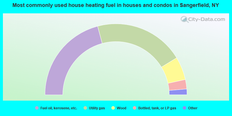
- 41.7%Fuel oil, kerosene, etc.
- 40.9%Utility gas
- 10.5%Wood
- 4.3%Bottled, tank, or LP gas
- 2.2%Electricity
- 0.5%Other fuel
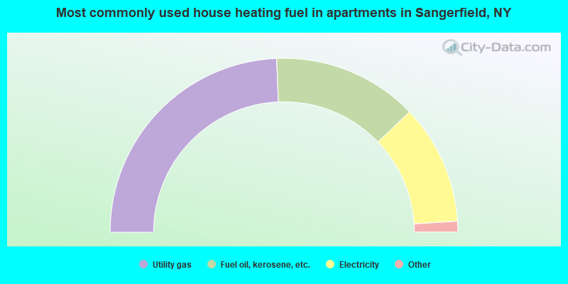
- 48.6%Utility gas
- 27.0%Fuel oil, kerosene, etc.
- 22.3%Electricity
- 0.7%Bottled, tank, or LP gas
- 0.7%Wood
- 0.7%Other fuel
Sangerfield compared to New York state average:
- Median house value significantly below state average.
- Unemployed percentage significantly below state average.
- Black race population percentage significantly below state average.
- Hispanic race population percentage significantly below state average.
- Foreign-born population percentage significantly below state average.
- Length of stay since moving in significantly above state average.
- Number of rooms per house significantly below state average.
- House age significantly below state average.
- Institutionalized population percentage above state average.
- Number of college students below state average.
- Percentage of population with a bachelor's degree or higher below state average.