Barnard, Tennessee
Submit your own pictures of this place and show them to the world
- OSM Map
- General Map
- Google Map
- MSN Map

| Males: 3,212 | |
| Females: 3,123 |
| Median resident age: | 40.5 years |
| Tennessee median age: | 35.9 years |
Zip code: 37880
| Barnard: | $70,479 |
| TN: | $65,254 |
Estimated per capita income in 2022: $36,833 (it was $18,248 in 2000)
Barnard CCD income, earnings, and wages data
Estimated median house or condo value in 2022: $248,073 (it was $83,000 in 2000)
| Barnard: | $248,073 |
| TN: | $284,800 |
Mean prices in 2022: all housing units: $311,752; detached houses: $346,844; townhouses or other attached units: $241,744; in 2-unit structures: $217,745; in 3-to-4-unit structures: $289,868; in 5-or-more-unit structures: $286,839; mobile homes: $115,492
Detailed information about poverty and poor residents in Barnard, TN


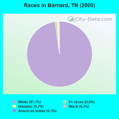
- 6,03197.7%White alone
- 560.9%Two or more races
- 430.7%Hispanic
- 200.3%Black alone
- 190.3%American Indian alone
- 40.06%Asian alone
Races in Barnard detailed stats: ancestries, foreign born residents, place of birth
 Recent articles from our blog. Our writers, many of them Ph.D. graduates or candidates, create easy-to-read articles on a wide variety of topics.
Current Local Time: EST time zone
Land area: 100.8 square miles.
Population density: 63 people per square mile (very low).

| Barnard CCD: | 0.8% ($667) |
| Tennessee: | 0.8% ($715) |
Nearest city with pop. 50,000+: Knoxville, TN  (38.9 miles , pop. 173,890).
Nearest city with pop. 200,000+: Nashville-Davidson, TN (125.0 miles , pop. 545,524).
Nearest city with pop. 1,000,000+: Chicago, IL (452.5 miles , pop. 2,896,016).
Nearest cities:
), ), Latitude: 35.76 N, Longitude: 84.58 W
Area code commonly used in this area: 865

| Here: | 3.4% |
| Tennessee: | 3.0% |
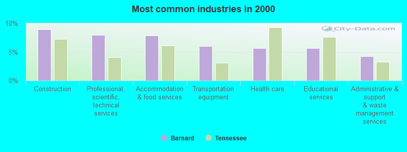
- Construction (8.9%)
- Professional, scientific, technical services (8.0%)
- Accommodation & food services (7.9%)
- Transportation equipment (6.0%)
- Health care (5.6%)
- Educational services (5.6%)
- Administrative & support & waste management services (4.2%)
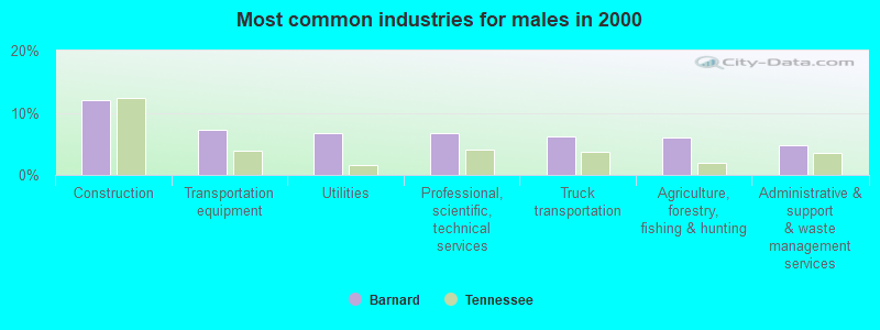
- Construction (12.1%)
- Transportation equipment (7.2%)
- Utilities (6.7%)
- Professional, scientific, technical services (6.7%)
- Truck transportation (6.2%)
- Agriculture, forestry, fishing & hunting (6.0%)
- Administrative & support & waste management services (4.8%)
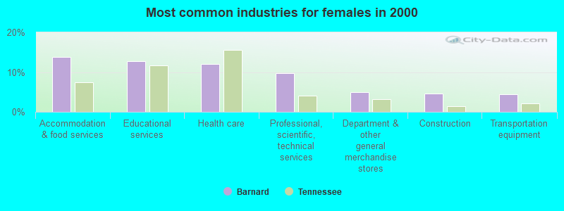
- Accommodation & food services (13.7%)
- Educational services (12.7%)
- Health care (12.0%)
- Professional, scientific, technical services (9.8%)
- Department & other general merchandise stores (4.9%)
- Construction (4.5%)
- Transportation equipment (4.4%)
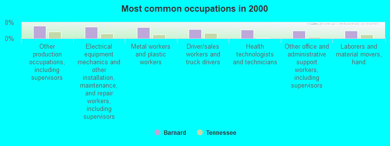
- Other production occupations, including supervisors (6.3%)
- Electrical equipment mechanics and other installation, maintenance, and repair workers, including supervisors (5.7%)
- Metal workers and plastic workers (5.5%)
- Driver/sales workers and truck drivers (4.7%)
- Health technologists and technicians (4.4%)
- Other office and administrative support workers, including supervisors (3.9%)
- Laborers and material movers, hand (3.9%)
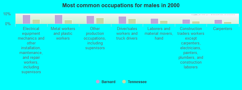
- Electrical equipment mechanics and other installation, maintenance, and repair workers, including supervisors (9.2%)
- Metal workers and plastic workers (9.0%)
- Other production occupations, including supervisors (8.1%)
- Driver/sales workers and truck drivers (7.5%)
- Laborers and material movers, hand (5.3%)
- Construction traders workers except carpenters, electricians, painters, plumbers, and construction laborers (4.5%)
- Carpenters (4.3%)
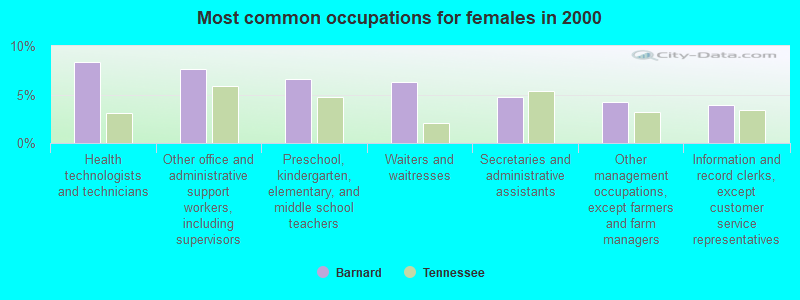
- Health technologists and technicians (8.4%)
- Other office and administrative support workers, including supervisors (7.6%)
- Preschool, kindergarten, elementary, and middle school teachers (6.6%)
- Waiters and waitresses (6.3%)
- Secretaries and administrative assistants (4.7%)
- Other management occupations, except farmers and farm managers (4.2%)
- Information and record clerks, except customer service representatives (3.9%)
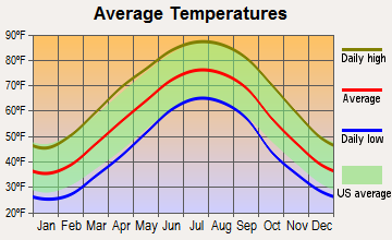
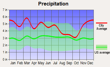
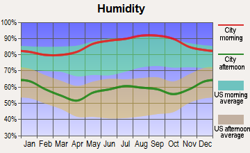
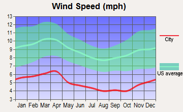
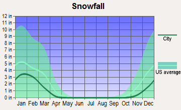
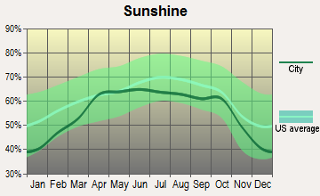
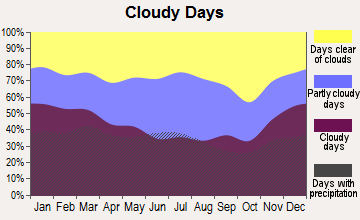
Average climate in Barnard, Tennessee
Based on data reported by over 4,000 weather stations
(lower is better)
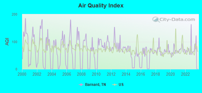
Air Quality Index (AQI) level in 2022 was 70.4. This is about average.
| City: | 70.4 |
| U.S.: | 72.6 |
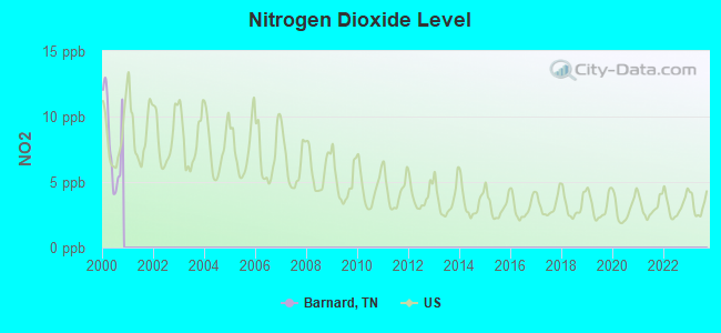
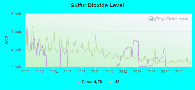
Sulfur Dioxide (SO2) [ppb] level in 2019 was 1.24. This is better than average. Closest monitor was 8.0 miles away from the city center.
| City: | 1.24 |
| U.S.: | 1.51 |
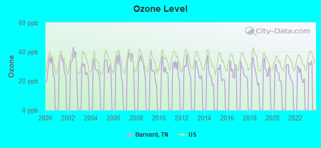
Ozone [ppb] level in 2022 was 24.6. This is better than average. Closest monitor was 8.9 miles away from the city center.
| City: | 24.6 |
| U.S.: | 33.3 |
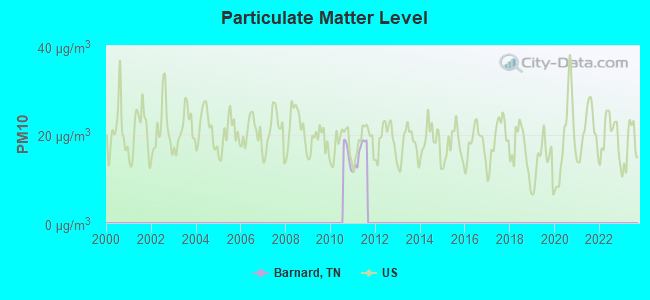
Particulate Matter (PM10) [µg/m3] level in 2011 was 15.8. This is better than average. Closest monitor was 9.8 miles away from the city center.
| City: | 15.8 |
| U.S.: | 19.2 |
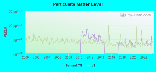
Particulate Matter (PM2.5) [µg/m3] level in 2022 was 6.70. This is better than average. Closest monitor was 9.8 miles away from the city center.
| City: | 6.70 |
| U.S.: | 8.11 |
Tornado activity:
Barnard-area historical tornado activity is below Tennessee state average. It is 8% smaller than the overall U.S. average.
On 5/2/1953, a category F4 (max. wind speeds 207-260 mph) tornado 17.6 miles away from the Barnard place center killed 4 people and injured 8 people and caused between $50,000 and $500,000 in damages.
On 2/21/1993, a category F3 (max. wind speeds 158-206 mph) tornado 10.5 miles away from the place center killed one person and injured 55 people and caused between $5000 and $50,000 in damages.
Earthquake activity:
Barnard-area historical earthquake activity is significantly above Tennessee state average. It is 100% greater than the overall U.S. average.On 11/30/1973 at 07:48:41, a magnitude 4.7 (4.7 MB, 4.6 ML, Class: Light, Intensity: IV - V) earthquake occurred 35.0 miles away from the city center
On 4/29/2003 at 08:59:39, a magnitude 4.9 (4.4 MB, 4.6 MW, 4.9 LG) earthquake occurred 105.6 miles away from Barnard center
On 7/27/1980 at 18:52:21, a magnitude 5.2 (5.1 MB, 4.7 MS, 5.0 UK, 5.2 UK, Class: Moderate, Intensity: VI - VII) earthquake occurred 172.9 miles away from the city center
On 12/12/2018 at 09:14:43, a magnitude 4.4 (4.4 MW, Depth: 4.9 mi) earthquake occurred 13.1 miles away from the city center
On 8/9/2020 at 12:07:37, a magnitude 5.1 (5.1 MW, Depth: 4.7 mi) earthquake occurred 201.3 miles away from Barnard center
On 4/18/2008 at 09:36:59, a magnitude 5.4 (5.1 MB, 4.8 MS, 5.4 MW, 5.2 MW) earthquake occurred 260.5 miles away from the city center
Magnitude types: regional Lg-wave magnitude (LG), body-wave magnitude (MB), local magnitude (ML), surface-wave magnitude (MS), moment magnitude (MW)
Natural disasters:
The number of natural disasters in Roane County (19) is greater than the US average (15).Major Disasters (Presidential) Declared: 14
Emergencies Declared: 2
Causes of natural disasters: Floods: 15, Storms: 13, Tornadoes: 4, Winter Storms: 3, Winds: 2, Heavy Rain: 1, Hurricane: 1, Landslide: 1, Mudslide: 1, Snowfall: 1, Other: 1 (Note: some incidents may be assigned to more than one category).
Hospitals and medical centers near Barnard:
- MICHAEL DUNN CENTER JULIA CAILLIOUETTE (Hospital, about 8 miles away; KINGSTON, TN)
- MICHAEL DUNN CENTER LEDA HERRON HOME (Hospital, about 8 miles away; KINGSTON, TN)
- RENAISSANCE TERRACE CARE AND REHABILITATION CENTER (Nursing Home, about 9 miles away; HARRIMAN, TN)
- (CLOSED) BAPTIST HOSPITAL OF ROANE COUNTY (Hospital, about 10 miles away; ROCKWOOD, TN)
- ARCON/BAPTIST HLTH CTR OF ROCKWOOD LLC (Hospital, about 10 miles away; ROCKWOOD, TN)
- KINGSTON DIALYSIS (Dialysis Facility, about 10 miles away; KINGSTON, TN)
- SWEETWATER HOSP HOME HEALTH (Home Health Center, about 13 miles away; SWEETWATER, TN)
Operable nuclear power plant near Barnard:
- 17 miles: Watts Bar 1 in Spring City, TN.
Colleges/universities with over 2000 students nearest to Barnard:
- Roane State Community College (about 9 miles; Harriman, TN; Full-time enrollment: 4,302)
- Pellissippi State Community College (about 27 miles; Knoxville, TN; FT enrollment: 7,271)
- The University of Tennessee-Knoxville (about 40 miles; Knoxville, TN; FT enrollment: 25,483)
- Cleveland State Community College (about 43 miles; Cleveland, TN; FT enrollment: 2,500)
- Lee University (about 45 miles; Cleveland, TN; FT enrollment: 4,422)
- Southern Adventist University (about 56 miles; Collegedale, TN; FT enrollment: 2,898)
- Chattanooga State Community College (about 59 miles; Chattanooga, TN; FT enrollment: 6,827)
Points of interest:
Notable locations in Barnard: Southwest Point Golf Course (A), Camp John Knox (B), Blue Springs Dock (C), Bayside Dock (D), South Roane County Volunteer Fire Department Station 1 (E), South Roane County Volunteer Fire Department Station 4 (F), South Roane County Volunteer Fire Department Station 3 (G), South Roane County Volunteer Fire Department Station 5 (H), South Roane County Volunteer Fire Department Station 2 (I). Display/hide their locations on the map
Churches in Barnard include: Erie Church (A), Chapman Grove Church (B), Ponder Church (C), Salem Church (D), Tennessee Chapel (E), Johnson Chapel (F), Compromise Church (G), Pleasant Hill Church (H), Bethel Church (I). Display/hide their locations on the map
Cemeteries: Hornsby Cemetery (1), Isham Cemetery (2), Jackson Cemetery (3), Johnson Cemetery (4), Union Star Cemetery (5), Kelsay Cemetery (6), Lacy Cemetery (7). Display/hide their locations on the map
Reservoirs: Claude Reed Lake (A), Watts Bar Lake (B). Display/hide their locations on the map
Streams, rivers, and creeks: Laurel Bluff Branch (A), Jackson Branch (B), Huffine Branch (C), Hood Branch (D), Greenbrier Branch (E), Gordon Branch (F), Evans Branch (G), Cedar Fork (H), Cane Creek (I). Display/hide their locations on the map
Park in Barnard: Riley Creek Recreational Area (1). Display/hide its location on the map
| This place: | 2.5 people |
| Tennessee: | 2.5 people |
| This place: | 67.3% |
| Whole state: | 69.8% |
| This place: | 3.1% |
| Whole state: | 4.2% |
Likely homosexual households (counted as self-reported same-sex unmarried-partner households)
- Lesbian couples: 0.0% of all households
- Gay men: 0.1% of all households
| This place: | 11.1% |
| Whole state: | 13.5% |
| This place: | 3.3% |
| Whole state: | 5.8% |
For population 15 years and over in Barnard:
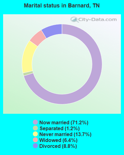
- Never married: 13.7%
- Now married: 71.2%
- Separated: 1.2%
- Widowed: 6.4%
- Divorced: 8.8%
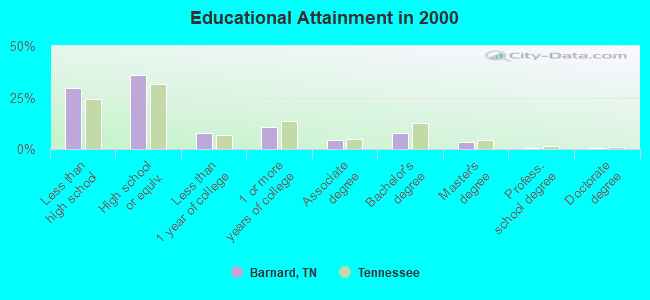
For population 25 years and over in Barnard:
- High school or higher: 70.2%
- Bachelor's degree or higher: 11.9%
- Graduate or professional degree: 4.4%
- Unemployed: 4.3%
- Mean travel time to work (commute): 30.0 minutes
| Here: | 14.0 |
| Tennessee average: | 13.3 |
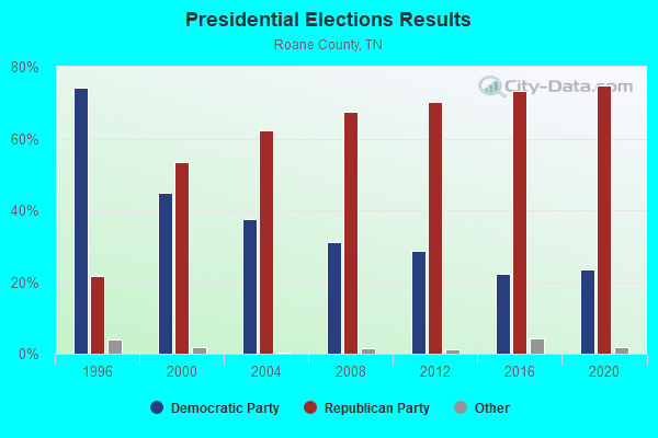
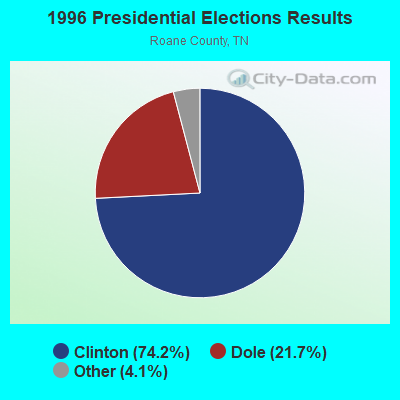
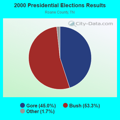

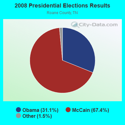

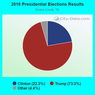
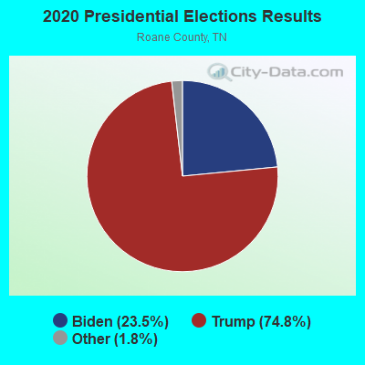
Graphs represent county-level data. Detailed 2008 Election Results
Religion statistics for Barnard, TN (based on Roane County data)

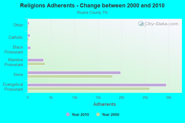
| Religion | Adherents | Congregations |
|---|---|---|
| Evangelical Protestant | 29,502 | 97 |
| Mainline Protestant | 3,385 | 20 |
| Black Protestant | 653 | 4 |
| Catholic | 500 | 1 |
| Other | 345 | 2 |
| None | 19,796 | - |
Food Environment Statistics:
| Roane County: | 1.50 / 10,000 pop. |
| Tennessee: | 1.99 / 10,000 pop. |
| This county: | 0.19 / 10,000 pop. |
| State: | 0.17 / 10,000 pop. |
| Roane County: | 0.94 / 10,000 pop. |
| Tennessee: | 0.65 / 10,000 pop. |
| Roane County: | 5.82 / 10,000 pop. |
| State: | 5.16 / 10,000 pop. |
| Here: | 4.13 / 10,000 pop. |
| State: | 6.56 / 10,000 pop. |
| This county: | 12.9% |
| Tennessee: | 11.4% |
| Roane County: | 31.1% |
| Tennessee: | 30.2% |
| This county: | 11.9% |
| State: | 13.5% |
Strongest AM radio stations in Barnard:
- WOFE (580 AM; 1 kW; ROCKWOOD, TN; Owner: SOUTHERN MEDIA GROUP, INC.)
- WKVL (850 AM; daytime; 50 kW; KNOXVILLE, TN; Owner: HORNE RADIO, LLC)
- WFLI (1070 AM; 50 kW; LOOKOUT MOUNTAIN, TN; Owner: WFLI, INC.)
- WWAM (820 AM; daytime; 50 kW; JASPER, TN; Owner: SHELTON BROADCASTING SYSTEM)
- WECO (940 AM; 5 kW; WARTBURG, TN; Owner: MORGAN COUNTY B/CASTING CO.)
- WMTY (670 AM; daytime; 2 kW; FARRAGUT, TN; Owner: HORNE RADIO, LLC)
- WDEH (800 AM; 1 kW; SWEETWATER, TN; Owner: HORNE RADIO, LLC)
- WQBB (1040 AM; daytime; 10 kW; POWELL, TN; Owner: JOURNAL BROADCAST CORPORATION)
- WNOX (990 AM; 10 kW; KNOXVILLE, TN)
- WLOD (1140 AM; daytime; 1 kW; LOUDON, TN; Owner: HORNE RADIO, LLC)
- WSM (650 AM; 50 kW; NASHVILLE, TN; Owner: GAYLORD ENTERTAINMENT COMPANY)
- WATO (1290 AM; 5 kW; OAK RIDGE, TN)
- WLIL (730 AM; 1 kW; LENOIR CITY, TN; Owner: BP BROADCASTERS, LLC)
Strongest FM radio stations in Barnard:
- WKTS (90.1 FM; KINGSTON, TN; Owner: THE KINGSTON CENTURY CLUB INC.)
- WWSR (105.7 FM; ROCKWOOD, TN; Owner: SOUTHERN MEDIA GROUP, INC.)
- WBZH (92.7 FM; HARRIMAN, TN; Owner: SOUTHERN MEDIA GROUP, INC.)
- WMKW (89.3 FM; CROSSVILLE, TN; Owner: THE MOODY BIBLE INSTITUTE OF CHICAGO)
- WLOD-FM (98.3 FM; SWEETWATER, TN; Owner: HORNE RADIO, LLC)
- WOKI-FM (100.3 FM; OAK RIDGE, TN; Owner: OAK RIDGE FM, INC.)
- WDVX (89.9 FM; CLINTON, TN; Owner: CUMBERLAND COMMUNITIES COMMUNI CORP.)
- WAYA (93.9 FM; SPRING CITY, TN; Owner: J. L. BREWER BROADCASTING OF CLEVELAND, LLC)
- WLLJ (103.1 FM; ETOWAH, TN; Owner: FRIENDSHIP BROADCASTING LLC.)
- WKZX-FM (93.5 FM; LENOIR CITY, TN; Owner: BP BROADCASTERS, LLC)
- WUOT (91.9 FM; KNOXVILLE, TN; Owner: UNIVERSITY OF TENNESSEE)
- WJSQ (101.7 FM; ATHENS, TN; Owner: JAMES C. SLIGER)
- WIVK-FM (107.7 FM; KNOXVILLE, TN; Owner: CITADEL BROADCASTING COMPANY)
- WWST (102.1 FM; SEVIERVILLE, TN; Owner: JOURNAL BROADCAST CORPORATION)
- WYGO (99.5 FM; MADISONVILLE, TN; Owner: MAJOR BROADCASTING CORPORATION)
- WOWF (102.5 FM; CROSSVILLE, TN; Owner: PEG BROADCASTING, INC.)
- WJXB-FM (97.5 FM; KNOXVILLE, TN; Owner: SOUTH CENTRAL COMMUNICATIONS CORP.)
- WCVP-FM (95.9 FM; ROBBINSVILLE, NC; Owner: CHEROKEE BROADCASTING COMPANY, INC.)
- WECO-FM (101.3 FM; WARTBURG, TN; Owner: MORGAN COUNTY BROADCASTING CO., INC.)
- WIMZ-FM (103.5 FM; KNOXVILLE, TN; Owner: SOUTH CENTRAL COMM., CORP.)
TV broadcast stations around Barnard:
- WDTT-LP (Channel 38; LENOIR CITY, TN; Owner: WORD OF GOD FELLOWSHIP, INC.)
- WFLI-TV (Channel 53; CLEVELAND, TN; Owner: CHATTANOOGA MEDIA HOLDINGS, L.L.C.)
- WVLT-TV (Channel 8; KNOXVILLE, TN; Owner: WVLT LICENSEE CORP.)
- W46DC (Channel 46; KNOXVILLE, TN; Owner: TRINITY BROADCASTING NETWORK)
- W50AB (Channel 50; HIAWASSEE, GA; Owner: GEORGIA PUBLIC TELECOMMUNICATIONS COMMISSION)
- WKOP-TV (Channel 15; KNOXVILLE, TN; Owner: EAST TENNESSEE PUBLIC COMMUNICATIONS CORP.)
- WBIR-TV (Channel 10; KNOXVILLE, TN; Owner: GANNETT PACIFIC CORPORATION)
- WATE-TV (Channel 6; KNOXVILLE, TN; Owner: WATE, G.P.)
- WTNZ (Channel 43; KNOXVILLE, TN; Owner: RAYCOM AMERICA, INC.)
- WBXX-TV (Channel 20; CROSSVILLE, TN; Owner: ACME TV LICENSES OF TENNESSEE, LLC)
- WEEE-LP (Channel 32; KNOXVILLE, TN; Owner: TIGER EYE BROADCASTING CORPORATION)
- WEZK-LP (Channel 28; KNOXVILLE, TN; Owner: SOUTH CENTRAL COMMUNICATIONS CORP.)
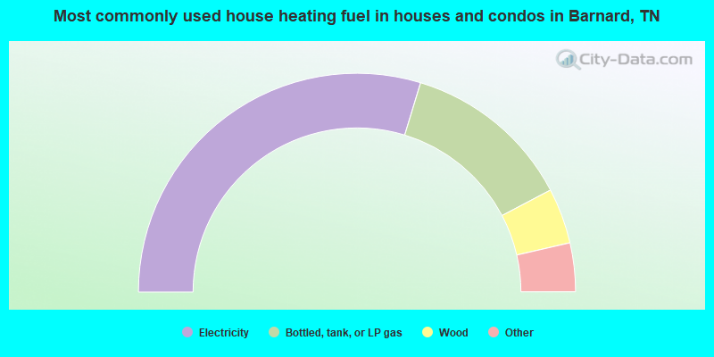
- 59.4%Electricity
- 25.2%Bottled, tank, or LP gas
- 8.2%Wood
- 3.3%Fuel oil, kerosene, etc.
- 2.3%Utility gas
- 1.6%No fuel used
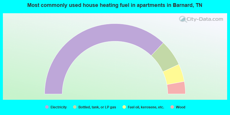
- 74.1%Electricity
- 12.1%Bottled, tank, or LP gas
- 8.1%Fuel oil, kerosene, etc.
- 5.7%Wood
Barnard compared to Tennessee state average:
- Unemployed percentage significantly below state average.
- Black race population percentage significantly below state average.
- Hispanic race population percentage significantly below state average.
- Foreign-born population percentage significantly below state average.
- Renting percentage significantly below state average.
- Length of stay since moving in significantly above state average.
- Number of rooms per house significantly below state average.
- House age significantly below state average.
- Number of college students below state average.
- Percentage of population with a bachelor's degree or higher below state average.
Barnard on our top lists:
- #6 on the list of "Top 101 cities with largest percentage of females in occupations: life, physical, and social science technicians (population 5,000+)"
- #7 on the list of "Top 101 cities with largest percentage of females in occupations: special education teachers (population 5,000+)"
- #9 on the list of "Top 101 cities with largest percentage of females in industries: nonmetallic mineral products (population 5,000+)"
- #10 on the list of "Top 101 cities with largest percentage of males in industries: nonmetallic mineral products (population 5,000+)"
- #12 on the list of "Top 101 cities with the smallest percentage of likely homosexual households (counted as self-reported same-sex unmarried-partner households) (population 5,000+)"
- #13 on the list of "Top 101 cities with largest percentage of males in industries: furniture and related product manufacturing (population 5,000+)"
- #14 on the list of "Top 101 cities with largest percentage of females in occupations: waiters and waitresses (population 5,000+)"
- #16 on the list of "Top 101 cities with largest percentage of males in industries: furniture and home furnishings, and household appliance stores (population 5,000+)"
- #22 on the list of "Top 101 cities with largest percentage of males in industries: furniture and home furnishing merchant wholesalers (population 5,000+)"
- #23 on the list of "Top 101 cities with largest percentage of females in industries: hardware, plumbing and heating equipment, and supplies merchant wholesalers (population 5,000+)"
- #23 on the list of "Top 101 cities with largest percentage of females in occupations: food processing workers (population 5,000+)"
- #24 on the list of "Top 101 cities with largest percentage of females in industries: music stores (population 5,000+)"
- #26 on the list of "Top 101 cities with largest percentage of males in occupations: woodworkers (population 5,000+)"
- #29 on the list of "Top 101 cities with largest percentage of females in occupations: engineers (population 5,000+)"
- #30 on the list of "Top 101 cities with largest percentage of males in industries: music stores (population 5,000+)"
- #30 on the list of "Top 101 cities with largest percentage of males in industries: used merchandise, gift, novelty, and souvenir, and other miscellaneous stores (population 5,000+)"
- #33 on the list of "Top 101 cities with largest percentage of males in industries: truck transportation (population 5,000+)"
- #37 on the list of "Top 101 cities with largest percentage of females in industries: transportation equipment (population 5,000+)"
- #44 on the list of "Top 101 cities with largest percentage of males in industries: plastics and rubber products (population 5,000+)"
- #47 on the list of "Top 101 cities with largest percentage of females in industries: apparel (population 5,000+)"
- #25 on the list of "Top 101 counties with the smallest number of children under 18 without health insurance coverage in 2000 (pop. 50,000+)"
- #38 on the list of "Top 101 counties with the highest number of deaths per 1000 residents 2007-2013 (pop. 50,000+)"
- #48 on the list of "Top 101 counties with the highest Particulate Matter (PM2.5) Annual air pollution readings in 2012 (µg/m3)"
- #68 on the list of "Top 101 counties with the lowest ground withdrawal of fresh water for public supply (pop. 50,000+)"
- #74 on the list of "Top 101 counties with the smallest number of people without health insurance coverage in 2000 (pop. 50,000+)"