Averill, Vermont
Submit your own pictures of this town and show them to the world
- OSM Map
- General Map
- Google Map
- MSN Map

Population change since 2000: 0.0%
 |
| Males: 3 | |
| Females: 5 |
| Median resident age: | 42.0 years |
| Vermont median age: | 37.7 years |
Zip code: 05907
| Averill: | $49,814 |
| VT: | $73,991 |
Estimated per capita income in 2022: $22,190 (it was $9,876 in 2000)
Estimated median house or condo value in 2022: over $1,000,000 (it was $562,500 in 2000)
| Averill: | over $1,000,000 |
| VT: | $304,700 |


 Recent articles from our blog. Our writers, many of them Ph.D. graduates or candidates, create easy-to-read articles on a wide variety of topics.
Current Local Time: EST time zone
Elevation: 1720 feet
Land area: 36.1 square miles.
Population density: 0.2 people per square mile (very low).

| Averill town: | 0.1% ($500) |
| Vermont: | 2.0% ($2,196) |
Nearest city with pop. 50,000+: Portland, ME  (114.5 miles , pop. 64,249).
Nearest city with pop. 200,000+: Boston, MA (185.4 miles , pop. 589,141).
Nearest city with pop. 1,000,000+: Bronx, NY (305.4 miles , pop. 1,332,650).
Nearest cities:
), ), ), )Latitude: 44.97 N, Longitude: 71.70 W
Area code commonly used in this area: 802


Average climate in Averill, Vermont
Based on data reported by over 4,000 weather stations


Earthquake activity:
Averill-area historical earthquake activity is significantly above Vermont state average. It is 78% smaller than the overall U.S. average.On 4/20/2002 at 10:50:47, a magnitude 5.3 (5.3 ML, Depth: 3.0 mi, Class: Moderate, Intensity: VI - VII) earthquake occurred 103.0 miles away from the city center
On 4/20/2002 at 10:50:47, a magnitude 5.2 (5.2 MB, 4.2 MS, 5.2 MW, 5.0 MW) earthquake occurred 104.6 miles away from Averill center
On 10/7/1983 at 10:18:46, a magnitude 5.3 (5.1 MB, 5.3 LG, 5.1 ML) earthquake occurred 148.1 miles away from the city center
On 1/19/1982 at 00:14:42, a magnitude 4.7 (4.5 MB, 4.7 MD, 4.5 LG, Class: Light, Intensity: IV - V) earthquake occurred 101.5 miles away from the city center
On 10/16/2012 at 23:12:25, a magnitude 4.7 (4.7 ML, Depth: 10.0 mi) earthquake occurred 107.8 miles away from Averill center
On 6/16/1995 at 12:13:11, a magnitude 3.8 (3.8 LG, Depth: 3.1 mi, Class: Light, Intensity: II - III) earthquake occurred 48.2 miles away from the city center
Magnitude types: regional Lg-wave magnitude (LG), body-wave magnitude (MB), duration magnitude (MD), local magnitude (ML), surface-wave magnitude (MS), moment magnitude (MW)
Natural disasters:
The number of natural disasters in Essex County (20) is greater than the US average (15).Major Disasters (Presidential) Declared: 15
Emergencies Declared: 1
Causes of natural disasters: Floods: 14, Storms: 13, Tropical Storms: 2, Winter Storms: 2, Heavy Rain: 1, Hurricane: 1, Landslide: 1, Other: 1 (Note: some incidents may be assigned to more than one category).
Colleges/universities with over 2000 students nearest to Averill:
- Norwich University (about 75 miles; Northfield, VT; Full-time enrollment: 4,221)
- University of Maine at Farmington (about 79 miles; Farmington, ME; FT enrollment: 2,036)
- Saint Michael's College (about 79 miles; Colchester, VT; FT enrollment: 2,336)
- Community College of Vermont (about 80 miles; Winooski, VT; FT enrollment: 3,394)
- University of Vermont (about 81 miles; Burlington, VT; FT enrollment: 11,566)
- Champlain College (about 82 miles; Burlington, VT; FT enrollment: 2,623)
- Plymouth State University (about 84 miles; Plymouth, NH; FT enrollment: 4,838)
Points of interest:
Notable locations in Averill: Camp Number Twentyone (A), Camp Number Twenty (B), Camp Number Nineteen (C), Camp Number Eighteen (D), Camp Number Sixteen (E). Display/hide their locations on the map
Lakes and reservoirs: Little Averill Pond (A), Forest Lake (B), Great Averill Pond (C), Little Averill Lake (D). Display/hide their locations on the map
Streams, rivers, and creeks: The Inlet (A), Spaulding Brook (B), La Pointe Brook (C), Black Brook (D). Display/hide their locations on the map
Drinking water stations with addresses in Averill and their reported violations in the past:
QUIMBY COUNTRY (Population served: 135, Groundwater):Past health violations:Past monitoring violations:
- MCL, Monthly (TCR) - In MAY-2011, Contaminant: Coliform. Follow-up actions: St Tech Assistance Visit (JUN-06-2011), St Formal NOV issued (JUN-06-2011), St Public Notif requested (JUN-06-2011), St Boil Water Order (JUN-06-2011), St Compliance achieved (FEB-11-2013)
- MCL, Monthly (TCR) - Between APR-2007 and JUN-2007, Contaminant: Coliform. Follow-up actions: St Public Notif received (OCT-13-2006), St Tech Assistance Visit (JUN-01-2007), St Formal NOV issued (JUN-01-2007), St Public Notif requested (JUN-01-2007), St Boil Water Order (JUN-01-2007), St Compliance achieved (SEP-25-2009)
- MCL, Monthly (TCR) - In SEP-2006, Contaminant: Coliform. Follow-up actions: St Tech Assistance Visit (SEP-29-2006), St Boil Water Order (SEP-29-2006), St Formal NOV issued (SEP-29-2006), St Public Notif requested (SEP-29-2006), St Public Notif received (OCT-12-2006), St Compliance achieved (SEP-25-2009)
- MCL, Monthly (TCR) - Between JUL-2006 and SEP-2006, Contaminant: Coliform. Follow-up actions: St Boil Water Order (AUG-23-2006), St Public Notif requested (AUG-23-2006), St Formal NOV issued (AUG-23-2006), St Tech Assistance Visit (AUG-23-2006), St Public Notif received (AUG-31-2006), St Compliance achieved (JUN-25-2007)
- MCL, Monthly (TCR) - Between APR-2006 and JUN-2006, Contaminant: Coliform. Follow-up actions: St Boil Water Order (JUN-28-2006), St Tech Assistance Visit (JUN-28-2006), St Public Notif requested (JUN-28-2006), St Formal NOV issued (JUN-28-2006), St Public Notif received (JUN-30-2006), St Compliance achieved (JUN-25-2007)
- One routine major monitoring violation
- 3 minor monitoring violations
- One regular monitoring violation
| This town: | 1.7 people |
| Vermont: | 2.3 people |
| This town: | 57.1% |
| Whole state: | 62.5% |
| This town: | 7.1% |
| Whole state: | 9.2% |
Likely homosexual households (counted as self-reported same-sex unmarried-partner households)
- Lesbian couples: 0.0% of all households
- Gay men: 7.1% of all households
For population 15 years and over in Averill:

- Never married: 47.1%
- Now married: 35.3%
- Separated: 0.0%
- Widowed: 0.0%
- Divorced: 17.6%
For population 25 years and over in Averill:
- High school or higher: 100.0%
- Bachelor's degree or higher: 0.0%
- Graduate or professional degree: 0.0%
- Mean travel time to work (commute): 17.3 minutes


| Here: | 4.1 |
| Vermont average: | 11.7 |
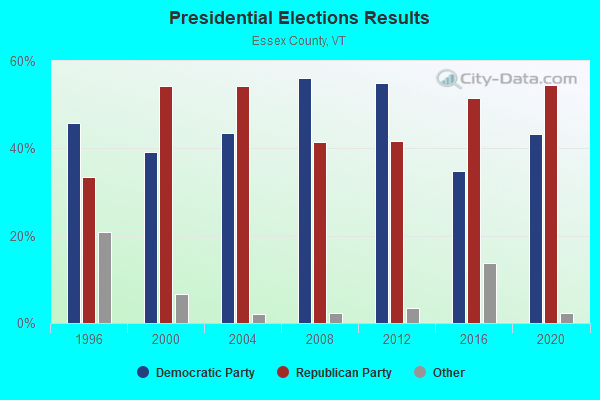
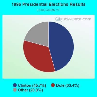
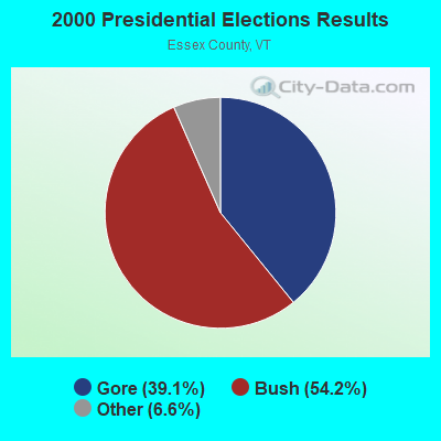
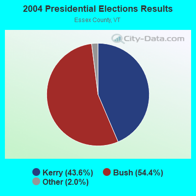
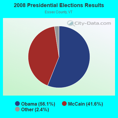

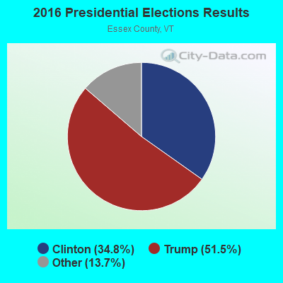
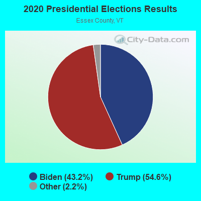
Graphs represent county-level data. Detailed 2008 Election Results
Religion statistics for Averill, VT (based on Essex County data)
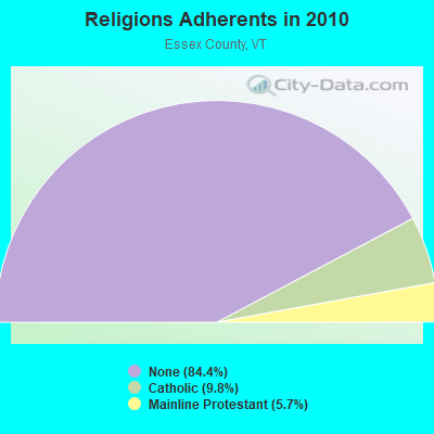
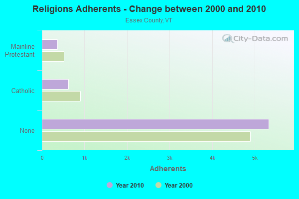
| Religion | Adherents | Congregations |
|---|---|---|
| Catholic | 619 | 2 |
| Mainline Protestant | 360 | 11 |
| Other | 3 | - |
| None | 5,324 | - |
Food Environment Statistics:
| Essex County: | 3.08 / 10,000 pop. |
| Vermont: | 3.84 / 10,000 pop. |
| Essex County: | 6.16 / 10,000 pop. |
| State: | 6.40 / 10,000 pop. |
| Here: | 15.40 / 10,000 pop. |
| State: | 11.52 / 10,000 pop. |
| This county: | 6.7% |
| Vermont: | 6.8% |
| Essex County: | 25.1% |
| Vermont: | 22.3% |
| This county: | 11.3% |
| State: | 13.3% |
Strongest AM radio stations in Averill:
- WCHP (760 AM; 35 kW; CHAMPLAIN, NY; Owner: CHAMPLAIN RADIO, INC.)
- WTME (780 AM; 10 kW; RUMFORD, ME; Owner: MOUNTAIN VALLEY BROADCASTING, INC.)
- WRKO (680 AM; 50 kW; BOSTON, MA; Owner: ENTERCOM BOSTON LICENSE, LLC)
- WICY (1490 AM; 50 kW; MALONE, NY; Owner: CARTIER COMMUNICATIONS INC.)
- WDEV (550 AM; 5 kW; WATERBURY, VT; Owner: RADIO VERMONT, INC.)
- WNNZ (640 AM; 50 kW; WESTFIELD, MA; Owner: CLEAR CHANNEL BROADCASTING LICENSES, INC.)
- WGY (810 AM; 50 kW; SCHENECTADY, NY; Owner: CLEAR CHANNEL BROADCASTING LICENSES, INC.)
- WCRN (830 AM; 50 kW; WORCESTER, MA; Owner: CARTER BROADCASTING CORPORATION)
- WEEI (850 AM; 50 kW; BOSTON, MA; Owner: ENTERCOM BOSTON LICENSE, LLC)
- WBZ (1030 AM; 50 kW; BOSTON, MA; Owner: INFINITY BROADCASTING OPERATIONS, INC.)
- WTWN (1100 AM; daytime; 5 kW; WELLS RIVER, VT; Owner: PUFFER BROADCASTING, INC.)
- WKOX (1200 AM; 50 kW; FRAMINGHAM, MA; Owner: CAPSTAR TX LIMITED PARTNERSHIP)
- WVMT (620 AM; 5 kW; BURLINGTON, VT; Owner: SISON BROADCASTING, INC.)
Strongest FM radio stations in Averill:
- WPKQ (103.7 FM; NORTH CONWAY, NH; Owner: CITADEL BROADCASTING COMPANY)
- WHOM (94.9 FM; MT. WASHINGTON, NH; Owner: CITADEL BROADCASTING COMPANY)
- WGMT (97.7 FM; LYNDON, VT; Owner: VERMONT BROADCAST ASSOCIATES, INC.)
- WMOO (92.1 FM; DERBY CENTER, VT; Owner: NORTHSTAR MEDIA, INC.)
- WLKC (103.3 FM; WATERBURY, VT; Owner: RADIO BROADCASTING SERVICES, INC.)
- WEZF (92.9 FM; BURLINGTON, VT; Owner: CAPSTAR TX LIMITED PARTNERSHIP)
- WVPS (107.9 FM; BURLINGTON, VT; Owner: VERMONT PUBLIC RADIO)
- WCVT (101.7 FM; STOWE, VT; Owner: RADIO VERMONT CLASSICS, L.L.C.)
- WTOS-FM (105.1 FM; SKOWHEGAN, ME; Owner: CAPSTAR TX LIMITED PARTNERSHIP)
- WMTK (106.3 FM; LITTLETON, NH; Owner: VERMONT BROADCAST ASSOCIATES, INC.)
- W243AE (96.5 FM; ORLEANS, VT; Owner: CHRISTIAN MINISTRIES, INC.)
- WXXS (102.3 FM; LANCASTER, NH; Owner: BARRY P. LUNDERVILLE)
- WDOT (95.7 FM; DANVILLE, VT; Owner: MONTPELIER BROADCASTING INC)

- 50.0%Bottled, tank, or LP gas
- 50.0%Wood
Averill compared to Vermont state average:
- Median house value significantly above state average.
- Unemployed percentage significantly below state average.
- Black race population percentage significantly below state average.
- Hispanic race population percentage significantly below state average.
- Foreign-born population percentage significantly below state average.
- Renting percentage significantly below state average.
- Length of stay since moving in significantly above state average.
- Number of rooms per house significantly below state average.
- House age significantly below state average.
- Number of college students significantly above state average.
- Percentage of population with a bachelor's degree or higher significantly below state average.
Averill on our top lists:
- #1 on the list of "Top 101 larger cities with the lowest real estate taxes percentage (population 50,000+)"
- #90 (05907) on the list of "Top 101 zip codes with the largest percentage of French Canadian first ancestries"
- #43 on the list of "Top 101 counties with the lowest surface withdrawal of fresh water for public supply"