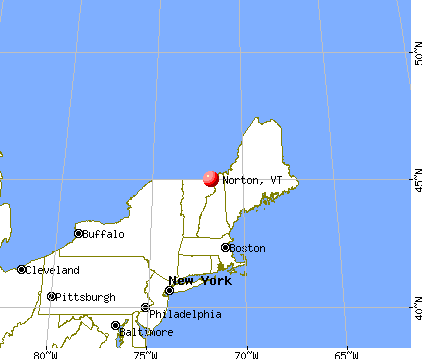
Norton, Vermont
Submit your own pictures of this town and show them to the world
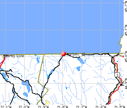
- OSM Map
- General Map
- Google Map
- MSN Map
Population change since 2000: -21.0%
| Males: 90 | |
| Females: 79 |
| Median resident age: | 54.8 years |
| Vermont median age: | 45.8 years |
Zip codes: 05907.
| Norton: | $36,228 |
| VT: | $73,991 |
Estimated per capita income in 2022: $34,840 (it was $15,506 in 2000)
Norton town income, earnings, and wages data
Estimated median house or condo value in 2022: $161,952 (it was $67,700 in 2000)
| Norton: | $161,952 |
| VT: | $304,700 |
Detailed information about poverty and poor residents in Norton, VT
Compare current foreclosures near Norton, VT:
| Photo | Address | Area | Beds / Baths | Price | Details |
|---|---|---|---|---|---|

|
#1
Salem Derby Rd
Newport, VT 05855
|
- sq. feet
|
1 baths 3 beds |
$119,900
|
show details |

|
#2
Vt Route 102
Canaan, VT 05903
|
1,296 sq. feet
|
1 baths 2 beds |
show details | |

|
#3
Vt Route 114
Canaan, VT 05903
|
- sq. feet
|
- baths - beds |
$54,900
|
show details |

|
#4
Clark St
Island Pond, VT 05846
|
- sq. feet
|
- baths - beds |
show details | |

|
#5
Vermont Route 102
Canaan, VT 05903
|
- sq. feet
|
- baths - beds |
show details | |

|
Check over 1 million property listings on Foreclosure.com!
|
browse all offers | |||

- 16798.8%White alone
- 10.6%Two or more races
- 10.6%Hispanic

Races in Norton detailed stats: ancestries, foreign born residents, place of birth
 Recent articles from our blog. Our writers, many of them Ph.D. graduates or candidates, create easy-to-read articles on a wide variety of topics.

 | Do all Vermonters drive like bats out of hell? (23 replies) |
| Unexpected job offer in Vermont (28 replies) |
| Vermont Weather (3779 replies) |
| disincorporation of Town of Victory proposed (5 replies) |
| Advice Needed: Same-Sex Couple in NEK (25 replies) |
| Trader Joe's, Whole Foods, French Bakeries and IKEA (43 replies) |
Latest news from Norton, VT collected exclusively by city-data.com from local newspapers, TV, and radio stations
Ancestries: French (11.7%), English (6.5%), French Canadian (6.1%), German (4.7%), Irish (4.2%), Swiss (1.9%).
Current Local Time: EST time zone
Elevation: 1260 feet
Land area: 39.1 square miles.
Population density: 4.3 people per square mile (very low).
18 residents are foreign born (4.7% Europe, 3.7% North America).
| This town: | 8.4% |
| Vermont: | 3.8% |
| Norton town: | 1.0% ($689) |
| Vermont: | 2.0% ($2,196) |
Nearest city with pop. 50,000+: Portland, ME  (118.6 miles , pop. 64,249).
Nearest city with pop. 200,000+: Boston, MA (186.8 miles , pop. 589,141).
Nearest city with pop. 1,000,000+: Bronx, NY (303.5 miles , pop. 1,332,650).
Nearest cities:
), ), ), ), Latitude: 44.97 N, Longitude: 71.82 W
Area code: 802


Single-family new house construction building permits:
- 2021: 1 building, cost: $259,200
- 2009: 1 building, cost: $185,000
- 2008: 2 buildings, average cost: $112,500
- 2007: 4 buildings, average cost: $112,500
- 2005: 9 buildings, average cost: $50,000
- 2004: 10 buildings, average cost: $50,000
- 2002: 1 building, cost: $45,000
- 2001: 2 buildings, average cost: $25,000
- 2000: 3 buildings, average cost: $56,700
- 1999: 1 building, cost: $50,000


| Here: | 6.4% |
| Vermont: | 2.0% |

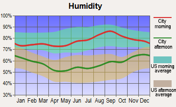
Average climate in Norton, Vermont
Based on data reported by over 4,000 weather stations


Earthquake activity:
Norton-area historical earthquake activity is significantly above Vermont state average. It is 78% smaller than the overall U.S. average.On 4/20/2002 at 10:50:47, a magnitude 5.3 (5.3 ML, Depth: 3.0 mi, Class: Moderate, Intensity: VI - VII) earthquake occurred 97.4 miles away from Norton center
On 4/20/2002 at 10:50:47, a magnitude 5.2 (5.2 MB, 4.2 MS, 5.2 MW, 5.0 MW) earthquake occurred 99.0 miles away from the city center
On 10/7/1983 at 10:18:46, a magnitude 5.3 (5.1 MB, 5.3 LG, 5.1 ML) earthquake occurred 142.9 miles away from the city center
On 1/19/1982 at 00:14:42, a magnitude 4.7 (4.5 MB, 4.7 MD, 4.5 LG, Class: Light, Intensity: IV - V) earthquake occurred 102.3 miles away from the city center
On 10/16/2012 at 23:12:25, a magnitude 4.7 (4.7 ML, Depth: 10.0 mi) earthquake occurred 111.1 miles away from the city center
On 6/16/1995 at 12:13:11, a magnitude 3.8 (3.8 LG, Depth: 3.1 mi, Class: Light, Intensity: II - III) earthquake occurred 47.6 miles away from the city center
Magnitude types: regional Lg-wave magnitude (LG), body-wave magnitude (MB), duration magnitude (MD), local magnitude (ML), surface-wave magnitude (MS), moment magnitude (MW)
Natural disasters:
The number of natural disasters in Essex County (20) is greater than the US average (15).Major Disasters (Presidential) Declared: 15
Emergencies Declared: 1
Causes of natural disasters: Floods: 14, Storms: 13, Tropical Storms: 2, Winter Storms: 2, Heavy Rain: 1, Hurricane: 1, Landslide: 1, Other: 1 (Note: some incidents may be assigned to more than one category).
Colleges/universities with over 2000 students nearest to Norton:
- Norwich University (about 71 miles; Northfield, VT; Full-time enrollment: 4,221)
- Saint Michael's College (about 74 miles; Colchester, VT; FT enrollment: 2,336)
- Community College of Vermont (about 75 miles; Winooski, VT; FT enrollment: 3,394)
- University of Vermont (about 76 miles; Burlington, VT; FT enrollment: 11,566)
- Champlain College (about 77 miles; Burlington, VT; FT enrollment: 2,623)
- SUNY College at Plattsburgh (about 83 miles; Plattsburgh, NY; FT enrollment: 5,934)
- Plymouth State University (about 85 miles; Plymouth, NH; FT enrollment: 4,838)
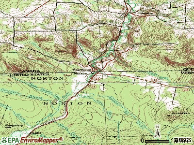
Points of interest:
Notable location: Lake (A). Display/hide its location on the map
Church in Norton: Saint Bernards Church (A). Display/hide its location on the map
Cemeteries: Saint Bernards Cemetery (1), Old Catholic Cemetery (2). Display/hide their locations on the map
Lakes and swamps: Halfway Pond (A), The Loon Hole (B). Display/hide their locations on the map
Streams, rivers, and creeks: Sutton Brook (A), Station Brook (B), Number Six Brook (C), Number Five Brook (D), Mosher Meadow Brook (E), Black Turn Brook (F), Davis Brook (G), Gaudette Brook (H). Display/hide their locations on the map
Park in Norton: Averill Mountain State Wildlife Management Area (1). Display/hide its location on the map
Drinking water stations with addresses in Norton and their reported violations in the past:
NORTON RESTAURANT (Population served: 86, Groundwater):Past monitoring violations:
- 24 routine major monitoring violations
- 8 regular monitoring violations
| This town: | 1.9 people |
| Vermont: | 2.3 people |
| This town: | 57.5% |
| Whole state: | 62.5% |
| This town: | 9.2% |
| Whole state: | 9.2% |
Likely homosexual households (counted as self-reported same-sex unmarried-partner households)
- Lesbian couples: 0.0% of all households
- Gay men: 2.3% of all households
| This town: | 14.6% |
| Whole state: | 9.4% |
| This town: | 9.8% |
| Whole state: | 3.6% |
For population 15 years and over in Norton:

- Never married: 23.2%
- Now married: 37.8%
- Separated: 4.9%
- Widowed: 17.1%
- Divorced: 17.1%
For population 25 years and over in Norton:
- High school or higher: 52.2%
- Bachelor's degree or higher: 5.8%
- Graduate or professional degree: 0.0%
- Mean travel time to work (commute): 23.0 minutes


| Here: | 12.8 |
| Vermont average: | 11.7 |
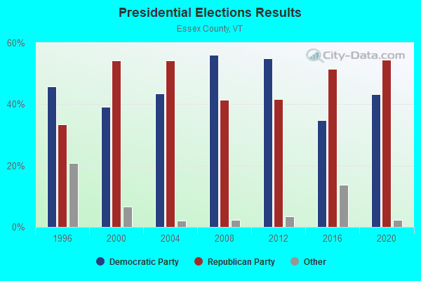
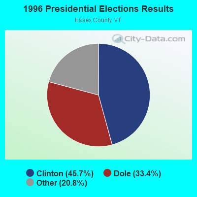
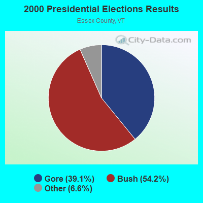
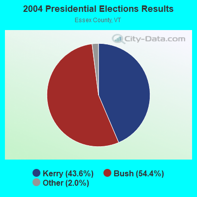
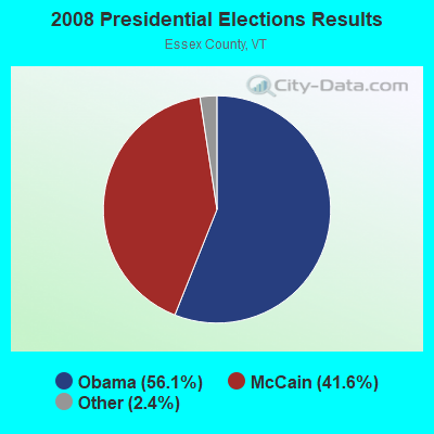

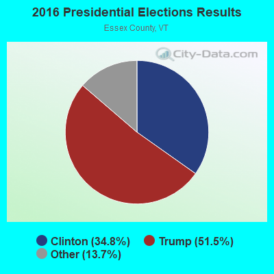
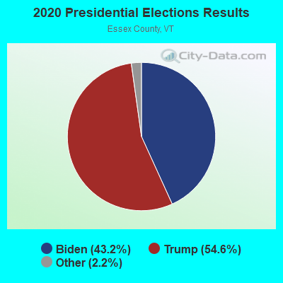
Graphs represent county-level data. Detailed 2008 Election Results
Religion statistics for Norton, VT (based on Essex County data)
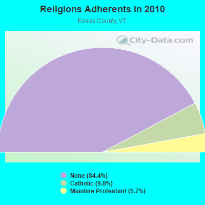
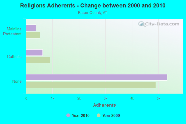
| Religion | Adherents | Congregations |
|---|---|---|
| Catholic | 619 | 2 |
| Mainline Protestant | 360 | 11 |
| Other | 3 | - |
| None | 5,324 | - |
Food Environment Statistics:
| This county: | 3.08 / 10,000 pop. |
| Vermont: | 3.84 / 10,000 pop. |
| Here: | 6.16 / 10,000 pop. |
| Vermont: | 6.40 / 10,000 pop. |
| Essex County: | 15.40 / 10,000 pop. |
| Vermont: | 11.52 / 10,000 pop. |
| Essex County: | 6.7% |
| Vermont: | 6.8% |
| This county: | 25.1% |
| State: | 22.3% |
| This county: | 11.3% |
| State: | 13.3% |
Strongest AM radio stations in Norton:
- WCHP (760 AM; 35 kW; CHAMPLAIN, NY; Owner: CHAMPLAIN RADIO, INC.)
- WICY (1490 AM; 50 kW; MALONE, NY; Owner: CARTIER COMMUNICATIONS INC.)
- WTME (780 AM; 10 kW; RUMFORD, ME; Owner: MOUNTAIN VALLEY BROADCASTING, INC.)
- WRKO (680 AM; 50 kW; BOSTON, MA; Owner: ENTERCOM BOSTON LICENSE, LLC)
- WDEV (550 AM; 5 kW; WATERBURY, VT; Owner: RADIO VERMONT, INC.)
- WNNZ (640 AM; 50 kW; WESTFIELD, MA; Owner: CLEAR CHANNEL BROADCASTING LICENSES, INC.)
- WIKE (1490 AM; 1 kW; NEWPORT, VT; Owner: NORTHSTAR MEDIA, INC.)
- WGY (810 AM; 50 kW; SCHENECTADY, NY; Owner: CLEAR CHANNEL BROADCASTING LICENSES, INC.)
- WCRN (830 AM; 50 kW; WORCESTER, MA; Owner: CARTER BROADCASTING CORPORATION)
- WEEI (850 AM; 50 kW; BOSTON, MA; Owner: ENTERCOM BOSTON LICENSE, LLC)
- WTWN (1100 AM; daytime; 5 kW; WELLS RIVER, VT; Owner: PUFFER BROADCASTING, INC.)
- WVMT (620 AM; 5 kW; BURLINGTON, VT; Owner: SISON BROADCASTING, INC.)
- WBZ (1030 AM; 50 kW; BOSTON, MA; Owner: INFINITY BROADCASTING OPERATIONS, INC.)
Strongest FM radio stations in Norton:
- WMOO (92.1 FM; DERBY CENTER, VT; Owner: NORTHSTAR MEDIA, INC.)
- WPKQ (103.7 FM; NORTH CONWAY, NH; Owner: CITADEL BROADCASTING COMPANY)
- WGMT (97.7 FM; LYNDON, VT; Owner: VERMONT BROADCAST ASSOCIATES, INC.)
- WHOM (94.9 FM; MT. WASHINGTON, NH; Owner: CITADEL BROADCASTING COMPANY)
- WLKC (103.3 FM; WATERBURY, VT; Owner: RADIO BROADCASTING SERVICES, INC.)
- WEZF (92.9 FM; BURLINGTON, VT; Owner: CAPSTAR TX LIMITED PARTNERSHIP)
- WVPS (107.9 FM; BURLINGTON, VT; Owner: VERMONT PUBLIC RADIO)
- WCVT (101.7 FM; STOWE, VT; Owner: RADIO VERMONT CLASSICS, L.L.C.)
- W243AE (96.5 FM; ORLEANS, VT; Owner: CHRISTIAN MINISTRIES, INC.)
- WNCS (104.7 FM; MONTPELIER, VT; Owner: MONTPELIER BROADCASTING, INC.)
- WMTK (106.3 FM; LITTLETON, NH; Owner: VERMONT BROADCAST ASSOCIATES, INC.)
- WDOT (95.7 FM; DANVILLE, VT; Owner: MONTPELIER BROADCASTING INC)
- WXXS (102.3 FM; LANCASTER, NH; Owner: BARRY P. LUNDERVILLE)
Norton fatal accident list:
Jan 11, 1987 12:45 AM, Vt114, Vehicles: 2, Persons: 3, Fatalities: 1, Drunk persons involved: 1
- National Bridge Inventory (NBI) Statistics
- 3Number of bridges
- 13ft / 3.5mTotal length
- $1,166,000Total costs
- 342Total average daily traffic
- 6Total average daily truck traffic
FCC Registered Antenna Towers:
8 (See the full list of FCC Registered Antenna Towers in Norton)FCC Registered Microwave Towers:
1- BROUSSEAU M, 3.8 Miles Se Of Intersection Sr114 And 147 (Lat: 44.968389 Lon: -71.743139), Type: Tower, Structure height: 15.5 m, Overall height: 18.3 m, Call Sign: WNEI777,
Assigned Frequencies: 6725.00 MHz, 6755.00 MHz, 6197.24 MHz, 6795.00 MHz, Grant Date: 12/23/2021, Expiration Date: 03/03/2032, Registrant: Utilties Technology Council, 2550 South Clark St., Suite 960, Arlington, VA 22202, Phone: (202) 872-0030, Fax: (315) 428-6689, Email:
FCC Registered Amateur Radio Licenses:
1- Call Sign: N1AIO, Grant Date: 09/18/1998, Expiration Date: 09/18/2008, Cancellation Date: 09/21/2010, Registrant: Michael N Dougherty, Norton, VT 05907-0024
Norton compared to Vermont state average:
- Median household income below state average.
- Median house value below state average.
- Unemployed percentage significantly below state average.
- Black race population percentage significantly below state average.
- Hispanic race population percentage significantly below state average.
- Median age significantly above state average.
- Foreign-born population percentage above state average.
- Renting percentage below state average.
- Length of stay since moving in significantly above state average.
- Number of rooms per house significantly below state average.
- House age significantly below state average.
- Number of college students significantly below state average.
- Percentage of population with a bachelor's degree or higher significantly below state average.