Auburn, Wisconsin
Submit your own pictures of this town and show them to the world
- OSM Map
- Google Map
- MSN Map
Population change since 2000: +13.3%
 |
| Males: 1,216 | |
| Females: 1,136 |
| Median resident age: | 43.1 years |
| Wisconsin median age: | 42.6 years |
Zip codes: 54724.
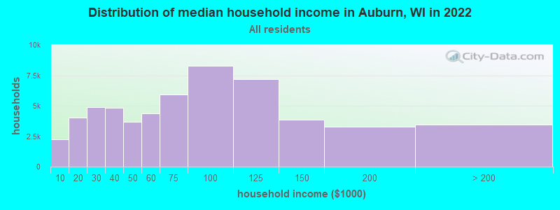
| Auburn: | $88,990 |
| WI: | $70,996 |
Estimated per capita income in 2022: $38,922 (it was $21,013 in 2000)
Auburn town income, earnings, and wages data
Estimated median house or condo value in 2022: $321,263 (it was $147,100 in 2000)
| Auburn: | $321,263 |
| WI: | $252,800 |
Mean prices in 2022: all housing units: $253,446; detached houses: $264,898; townhouses or other attached units: $220,861; in 2-unit structures: $156,740; in 3-to-4-unit structures: $141,668; in 5-or-more-unit structures: $118,941; mobile homes: $48,221
Detailed information about poverty and poor residents in Auburn, WI
Compare current foreclosures near Auburn, WI:
| Photo | Address | Area | Beds / Baths | Price | Details |
|---|---|---|---|---|---|

|
#1
Raven St
West Bend, WI 53090
|
1,650 sq. feet
|
1 baths 4 beds |
show details | |

|
#2
Minz Park Cir Apt 4
West Bend, WI 53095
|
1,098 sq. feet
|
1 baths 2 beds |
show details | |

|
#3
High St
West Bend, WI 53090
|
1,400 sq. feet
|
1 baths 3 beds |
show details | |

|
#4
Hans St
West Bend, WI 53090
|
1,324 sq. feet
|
2 baths 3 beds |
show details | |

|
#5
Creekwood Ln
West Bend, WI 53095
|
1,780 sq. feet
|
2 baths 3 beds |
show details | |

|
#6
Cherry St
West Bend, WI 53090
|
1,484 sq. feet
|
2 baths 4 beds |
show details | |

|
#7
Green Tree Rd
West Bend, WI 53090
|
1,064 sq. feet
|
1 baths 2 beds |
show details | |

|
#8
Arbor Vitae Dr
West Bend, WI 53095
|
- sq. feet
|
2 baths 3 beds |
show details | |

|
#9
N University Dr Unit 123
West Bend, WI 53095
|
1,145 sq. feet
|
2 baths 2 beds |
show details | |

|
#10
Creekside Pl
West Bend, WI 53095
|
2,822 sq. feet
|
2 baths 4 beds |
show details |
| Photo | Address | Area | Beds / Baths | Price | Details |
|---|---|---|---|---|---|

|
#11
Dubin Cir
West Bend, WI 53090
|
2,028 sq. feet
|
3 baths 3 beds |
show details | |

|
#12
Miller St
West Bend, WI 53095
|
1,081 sq. feet
|
1 baths 2 beds |
show details | |

|
#13
Goldenrod Cir
West Bend, WI 53095
|
1,406 sq. feet
|
2 baths 3 beds |
show details | |

|
#14
S Indiana Ave
West Bend, WI 53095
|
1,066 sq. feet
|
1 baths 3 beds |
show details | |

|
#15
Clarence Ct Apt 5
West Bend, WI 53095
|
1,204 sq. feet
|
1 baths 2 beds |
show details | |

|
#16
S Main St
West Bend, WI 53095
|
1,560 sq. feet
|
2 baths 3 beds |
show details | |

|
#17
Terrace Dr
West Bend, WI 53095
|
1,245 sq. feet
|
1 baths 3 beds |
show details | |

|
#18
Birchwood Dr
West Bend, WI 53095
|
864 sq. feet
|
1 baths 3 beds |
show details | |

|
#19
Edgewater Dr
West Bend, WI 53095
|
2,230 sq. feet
|
2 baths 4 beds |
show details | |

|
#20
Wayne Rd
West Bend, WI 53090
|
1,378 sq. feet
|
2 baths 3 beds |
show details |
| Photo | Address | Area | Beds / Baths | Price | Details |
|---|---|---|---|---|---|

|
#21
Squire Ln
West Bend, WI 53090
|
1,966 sq. feet
|
2 baths 3 beds |
show details | |

|
#22
Larkspur Ln
West Bend, WI 53090
|
2,284 sq. feet
|
2 baths 3 beds |
show details | |

|
#23
Grant Pl
West Bend, WI 53090
|
1,318 sq. feet
|
2 baths 3 beds |
show details | |

|
#24
N Salisbury Rd
West Bend, WI 53090
|
802 sq. feet
|
1 baths 2 beds |
show details | |

|
#25
N 18th Ave
West Bend, WI 53090
|
1,685 sq. feet
|
2 baths 4 beds |
show details | |

|
#26
Kettle Ct
West Bend, WI 53090
|
3,792 sq. feet
|
3 baths 4 beds |
show details | |

|
#27
Maple Ct
Random Lake, WI 53075
|
- sq. feet
|
- baths - beds |
show details | |

|
#28
Diane Dr Apt 10
West Bend, WI 53090
|
- sq. feet
|
- baths - beds |
show details | |

|
#29
W Paradise Dr
West Bend, WI 53095
|
- sq. feet
|
- baths - beds |
show details | |

|
#30
W Guindon Blvd
Fond Du Lac, WI 54935
|
- sq. feet
|
- baths - beds |
show details |
| Photo | Address | Area | Beds / Baths | Price | Details |
|---|---|---|---|---|---|

|
#31
Stonebridge Rd Apt 104
West Bend, WI 53095
|
- sq. feet
|
- baths - beds |
show details | |

|
#32
Pierce Rd
Mayville, WI 53050
|
- sq. feet
|
- baths - beds |
show details | |

|
#33
Reed St Apt B
Plymouth, WI 53073
|
- sq. feet
|
- baths - beds |
show details | |

|
#34
Prairie Rd # 5
Fond Du Lac, WI 54935
|
- sq. feet
|
- baths - beds |
show details | |

|
#35
Ledge Rd
Mount Calvary, WI 53057
|
- sq. feet
|
- baths - beds |
show details | |

|
#36
Dairy Rd, Ste B
Mayville, WI 53050
|
- sq. feet
|
- baths - beds |
show details | |

|
#37
Maple Dr
Campbellsport, WI 53010
|
- sq. feet
|
- baths - beds |
show details | |

|
#38
S Milwaukee St
Theresa, WI 53091
|
- sq. feet
|
- baths - beds |
show details | |

|
#39
S Main St # 9
Fond Du Lac, WI 54935
|
- sq. feet
|
- baths - beds |
show details | |

|
#40
S Spring St # 203
Random Lake, WI 53075
|
- sq. feet
|
- baths - beds |
show details |
| Photo | Address | Area | Beds / Baths | Price | Details |
|---|---|---|---|---|---|

|
#41
S Main St Apt 1
Fond Du Lac, WI 54935
|
- sq. feet
|
- baths - beds |
show details | |

|
#42
County Road Y
Saukville, WI 53080
|
- sq. feet
|
- baths - beds |
show details | |

|
#43
Aurora Rd
Allenton, WI 53002
|
- sq. feet
|
- baths - beds |
show details | |

|
#44
Poplar Rd
Fond Du Lac, WI 54937
|
- sq. feet
|
- baths - beds |
show details | |

|
#45
County Road Tw
Mayville, WI 53050
|
- sq. feet
|
- baths - beds |
show details | |

|
#46
4th St # 4
Fond Du Lac, WI 54935
|
- sq. feet
|
- baths - beds |
show details | |

|
#47
Appleton St Apt 212
Plymouth, WI 53073
|
- sq. feet
|
- baths - beds |
show details | |

|
#48
Sherwood Ave Apt 10
Fond Du Lac, WI 54935
|
- sq. feet
|
- baths - beds |
show details | |

|
#49
Sherwood Ave Apt 4
Fond Du Lac, WI 54935
|
- sq. feet
|
- baths - beds |
show details | |

|
Check over 1 million property listings on Foreclosure.com!
|
browse all offers | |||

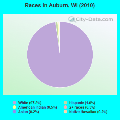
- 2,30097.8%White alone
- 241.0%Hispanic
- 120.5%American Indian alone
- 80.3%Two or more races
- 40.2%Asian alone
- 40.2%Native Hawaiian and Other
Pacific Islander alone
Races in Auburn detailed stats: ancestries, foreign born residents, place of birth
 Recent articles from our blog. Our writers, many of them Ph.D. graduates or candidates, create easy-to-read articles on a wide variety of topics.
Ancestries: German (73.3%), Irish (9.1%), Polish (6.4%), United States (5.5%), English (4.3%), French (2.5%).
Current Local Time: CST time zone
Land area: 35.2 square miles.
Population density: 67 people per square mile (very low).
15 residents are foreign born
| This town: | 0.7% |
| Wisconsin: | 3.6% |
| Auburn town: | 1.6% ($2,362) |
| Wisconsin: | 2.0% ($2,245) |
Nearest city with pop. 50,000+: Sheboygan, WI  (26.9 miles , pop. 50,792).
Nearest city with pop. 200,000+: Milwaukee, WI (39.2 miles , pop. 596,974).
Nearest city with pop. 1,000,000+: Chicago, IL (123.8 miles , pop. 2,896,016).
Nearest cities:
), ), ), ), ), )Latitude: 43.59 N, Longitude: 88.21 W
Area code commonly used in this area: 920
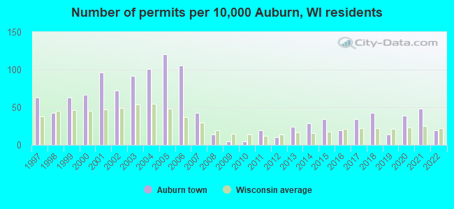
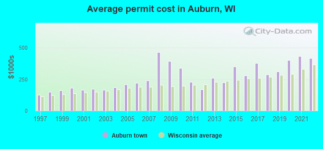
Single-family new house construction building permits:
- 2022: 4 buildings, average cost: $417,800
- 2021: 10 buildings, average cost: $434,400
- 2020: 8 buildings, average cost: $401,700
- 2019: 3 buildings, average cost: $313,300
- 2018: 9 buildings, average cost: $288,400
- 2017: 7 buildings, average cost: $379,600
- 2016: 4 buildings, average cost: $278,800
- 2015: 7 buildings, average cost: $350,700
- 2014: 6 buildings, average cost: $223,500
- 2013: 5 buildings, average cost: $258,800
- 2012: 2 buildings, average cost: $167,500
- 2011: 4 buildings, average cost: $229,800
- 2010: 1 building, cost: $340,000
- 2009: 1 building, cost: $395,000
- 2008: 3 buildings, average cost: $465,000
- 2007: 9 buildings, average cost: $241,400
- 2006: 22 buildings, average cost: $220,600
- 2005: 25 buildings, average cost: $207,000
- 2004: 21 buildings, average cost: $184,100
- 2003: 19 buildings, average cost: $166,300
- 2002: 15 buildings, average cost: $174,500
- 2001: 20 buildings, average cost: $166,400
- 2000: 14 buildings, average cost: $180,200
- 1999: 13 buildings, average cost: $162,100
- 1998: 9 buildings, average cost: $148,900
- 1997: 13 buildings, average cost: $128,200
| Here: | 2.2% |
| Wisconsin: | 2.7% |
- Construction (9.6%)
- Machinery (8.7%)
- Health care (8.2%)
- Printing & related support activities (4.8%)
- Truck transportation (4.6%)
- Agriculture, forestry, fishing & hunting (3.9%)
- Educational services (3.9%)
- Construction (16.2%)
- Machinery (13.6%)
- Truck transportation (6.2%)
- Agriculture, forestry, fishing & hunting (5.0%)
- Metal & metal products (4.7%)
- Electrical equipment, appliances, components (4.7%)
- Printing & related support activities (4.0%)
- Health care (17.1%)
- Educational services (7.0%)
- Printing & related support activities (5.7%)
- Accommodation & food services (5.3%)
- Finance & insurance (4.5%)
- Miscellaneous manufacturing (3.9%)
- Machinery (3.0%)
- Metal workers and plastic workers (8.4%)
- Driver/sales workers and truck drivers (7.2%)
- Other production occupations, including supervisors (7.0%)
- Material recording, scheduling, dispatching, and distributing workers (3.9%)
- Secretaries and administrative assistants (3.6%)
- Electrical equipment mechanics and other installation, maintenance, and repair workers, including supervisors (3.1%)
- Building and grounds cleaning and maintenance occupations (3.0%)
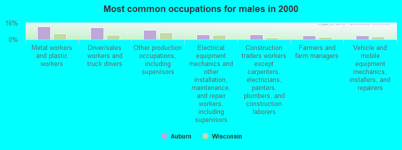
- Metal workers and plastic workers (12.5%)
- Driver/sales workers and truck drivers (11.7%)
- Other production occupations, including supervisors (9.1%)
- Electrical equipment mechanics and other installation, maintenance, and repair workers, including supervisors (5.0%)
- Construction traders workers except carpenters, electricians, painters, plumbers, and construction laborers (4.7%)
- Farmers and farm managers (4.1%)
- Vehicle and mobile equipment mechanics, installers, and repairers (4.0%)
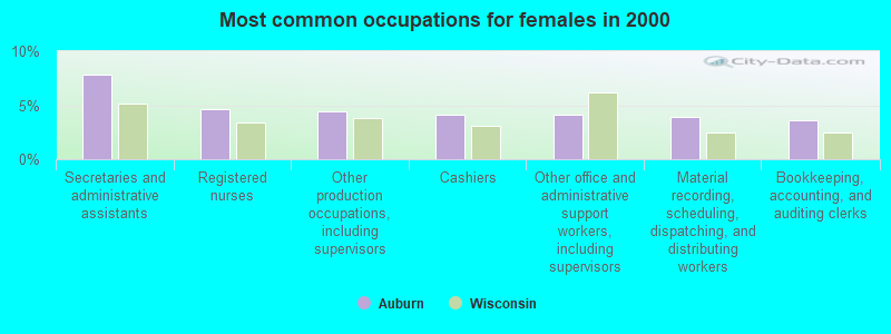
- Secretaries and administrative assistants (7.8%)
- Registered nurses (4.6%)
- Other production occupations, including supervisors (4.5%)
- Cashiers (4.1%)
- Other office and administrative support workers, including supervisors (4.1%)
- Material recording, scheduling, dispatching, and distributing workers (3.9%)
- Bookkeeping, accounting, and auditing clerks (3.6%)
Average climate in Auburn, Wisconsin
Based on data reported by over 4,000 weather stations


(lower is better)
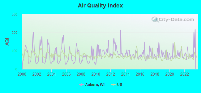
Air Quality Index (AQI) level in 2022 was 76.7. This is about average.
| City: | 76.7 |
| U.S.: | 72.6 |

Carbon Monoxide (CO) [ppm] level in 2022 was 0.198. This is better than average. Closest monitor was 19.0 miles away from the city center.
| City: | 0.198 |
| U.S.: | 0.251 |
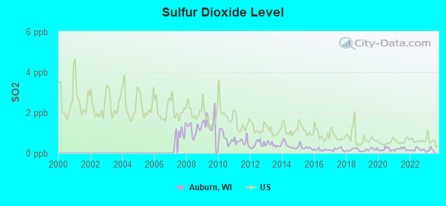
Sulfur Dioxide (SO2) [ppb] level in 2022 was 0.173. This is significantly better than average. Closest monitor was 17.2 miles away from the city center.
| City: | 0.173 |
| U.S.: | 1.515 |
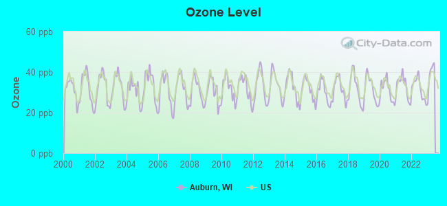
Ozone [ppb] level in 2022 was 31.9. This is about average. Closest monitor was 16.1 miles away from the city center.
| City: | 31.9 |
| U.S.: | 33.3 |

Particulate Matter (PM10) [µg/m3] level in 2022 was 14.1. This is better than average. Closest monitor was 19.0 miles away from the city center.
| City: | 14.1 |
| U.S.: | 19.2 |
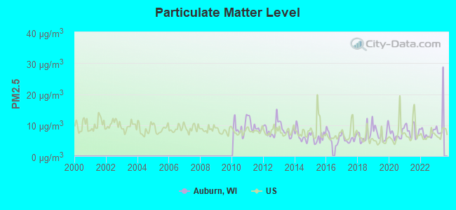
Particulate Matter (PM2.5) [µg/m3] level in 2022 was 7.29. This is about average. Closest monitor was 19.0 miles away from the city center.
| City: | 7.29 |
| U.S.: | 8.11 |
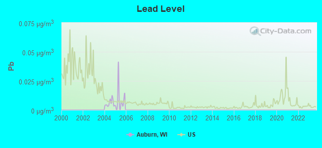
Lead (Pb) [µg/m3] level in 2005 was 0.0105. This is about average. Closest monitor was 17.6 miles away from the city center.
| City: | 0.0105 |
| U.S.: | 0.0093 |
Tornado activity:
Auburn-area historical tornado activity is slightly above Wisconsin state average. It is 37% greater than the overall U.S. average.
On 7/18/1996, a category F5 (max. wind speeds 261-318 mph) tornado 12.4 miles away from the Auburn town center injured 12 people and caused $40 million in damages.
On 4/4/1981, a category F4 (max. wind speeds 207-260 mph) tornado 10.9 miles away from the town center killed 3 people and injured 53 people and caused between $5,000,000 and $50,000,000 in damages.
Earthquake activity:
Auburn-area historical earthquake activity is significantly above Wisconsin state average. It is 0% greater than the overall U.S. average.On 4/18/2008 at 09:36:59, a magnitude 5.4 (5.1 MB, 4.8 MS, 5.4 MW, 5.2 MW, Class: Moderate, Intensity: VI - VII) earthquake occurred 355.6 miles away from Auburn center
On 6/28/2004 at 06:10:52, a magnitude 4.2 (4.2 MW, Depth: 6.2 mi, Class: Light, Intensity: IV - V) earthquake occurred 151.3 miles away from the city center
On 6/10/1987 at 23:48:54, a magnitude 5.1 (4.9 MB, 4.4 MS, 4.6 MS, 5.1 LG) earthquake occurred 330.1 miles away from Auburn center
On 5/2/2015 at 16:23:07, a magnitude 4.2 (4.2 MW, Depth: 2.8 mi) earthquake occurred 169.2 miles away from the city center
On 4/18/2008 at 09:36:59, a magnitude 5.2 (5.2 MW, Depth: 8.9 mi) earthquake occurred 355.6 miles away from Auburn center
On 2/10/2010 at 09:59:35, a magnitude 3.8 (3.8 MW, Depth: 6.2 mi, Class: Light, Intensity: II - III) earthquake occurred 112.9 miles away from Auburn center
Magnitude types: regional Lg-wave magnitude (LG), body-wave magnitude (MB), surface-wave magnitude (MS), moment magnitude (MW)
Natural disasters:
The number of natural disasters in Fond du Lac County (11) is smaller than the US average (15).Major Disasters (Presidential) Declared: 8
Emergencies Declared: 2
Causes of natural disasters: Floods: 7, Storms: 6, Tornadoes: 4, Winds: 2, Drought: 1, Hurricane: 1, Landslide: 1, Other: 1 (Note: some incidents may be assigned to more than one category).
Hospitals and medical centers near Auburn:
- SAMARITAN HEALTH CENTER (Nursing Home, about 12 miles away; WEST BEND, WI)
- HOPE HEALTH AND REHAB (Nursing Home, about 12 miles away; LOMIRA, WI)
- HOPE NURSING HOME INC (Nursing Home, about 12 miles away; LOMIRA, WI)
- CEDAR COMMUNITY HOME HEALTH AGENCY (Home Health Center, about 14 miles away; WEST BEND, WI)
Colleges/universities with over 2000 students nearest to Auburn:
- Marian University (about 17 miles; Fond Du Lac, WI; Full-time enrollment: 2,045)
- Moraine Park Technical College (about 18 miles; Fond du Lac, WI; FT enrollment: 3,079)
- Lakeland College (about 25 miles; Plymouth, WI; FT enrollment: 2,395)
- Concordia University-Wisconsin (about 28 miles; Mequon, WI; FT enrollment: 5,253)
- Cardinal Stritch University (about 35 miles; Milwaukee, WI; FT enrollment: 3,595)
- University of Wisconsin-Oshkosh (about 35 miles; Oshkosh, WI; FT enrollment: 10,637)
- Waukesha County Technical College (about 36 miles; Pewaukee, WI; FT enrollment: 4,415)
Points of interest:
Notable location: Kettle Moraine Youth Camp (A). Display/hide its location on the map
Churches in Auburn include: Saint Matthias Catholic Church (A), Saint John Evangelical Lutheran Church (B). Display/hide their locations on the map
Cemeteries: New Prospect Cemetery (1), Auburn Cemetery (2), Saint Johns Cemetery (3), Saint Mathias Cemetery (4), Gage Cemetery (5). Display/hide their locations on the map
Lakes and reservoirs: New Fane Millpond (A), Auburn Lake (B), Spring Lake (C), Buttermilk Lake (D), Butzke Lake (E), Dickman Lake (F), Forest Lake (G), Little Mud Lake (H). Display/hide their locations on the map
Creeks: Auburn Lake Creek (A), Virgin Creek (B). Display/hide their locations on the map
Parks in Auburn include: Crooked Lake Wetlands State Natural Area (1), Haskell Noyes Memorial Woods State Natural Area (2), Milwaukee River and Swamp State Natural Area (3), Spring Lake State Natural Area (4), Mauthe Lake Recreation Area (5). Display/hide their locations on the map
| This town: | 2.7 people |
| Wisconsin: | 2.4 people |
| This town: | 80.5% |
| Whole state: | 64.4% |
| This town: | 5.4% |
| Whole state: | 7.3% |
Likely homosexual households (counted as self-reported same-sex unmarried-partner households)
- Lesbian couples: 0.1% of all households
- Gay men: 0.3% of all households
| This town: | 1.3% |
| Whole state: | 8.7% |
| This town: | 0.1% |
| Whole state: | 3.7% |
For population 15 years and over in Auburn:
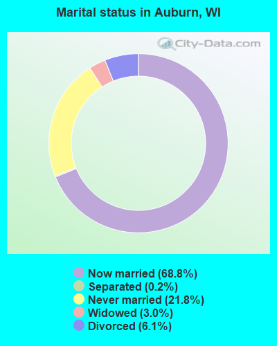
- Never married: 21.8%
- Now married: 68.8%
- Separated: 0.2%
- Widowed: 3.0%
- Divorced: 6.1%
For population 25 years and over in Auburn:
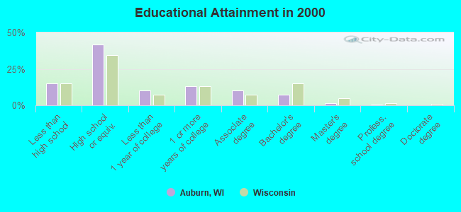
- High school or higher: 84.8%
- Bachelor's degree or higher: 9.2%
- Graduate or professional degree: 1.8%
- Unemployed: 4.6%
- Mean travel time to work (commute): 25.7 minutes
| Here: | 8.1 |
| Wisconsin average: | 11.0 |
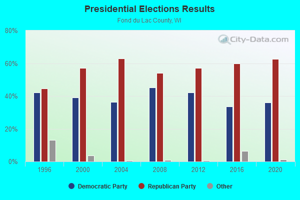
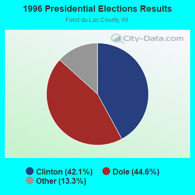
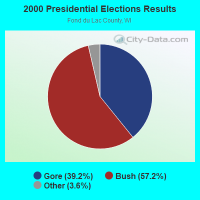
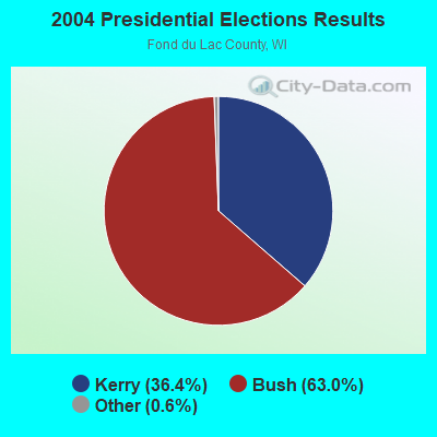
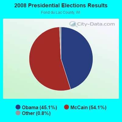
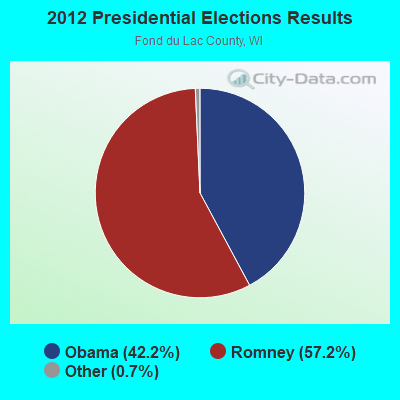
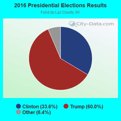
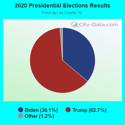
Graphs represent county-level data. Detailed 2008 Election Results
Religion statistics for Auburn, WI (based on Fond du Lac County data)
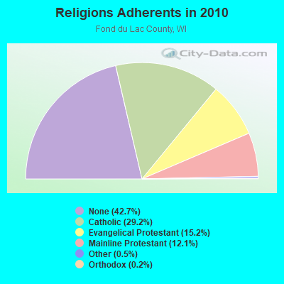
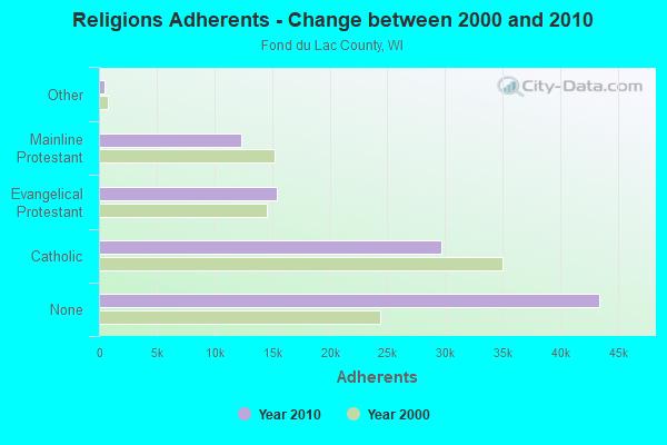
| Religion | Adherents | Congregations |
|---|---|---|
| Catholic | 29,714 | 15 |
| Evangelical Protestant | 15,457 | 44 |
| Mainline Protestant | 12,339 | 32 |
| Other | 500 | 6 |
| Orthodox | 220 | 1 |
| None | 43,403 | - |
Food Environment Statistics:
| Fond du Lac County: | 1.21 / 10,000 pop. |
| State: | 1.86 / 10,000 pop. |
| This county: | 4.64 / 10,000 pop. |
| State: | 4.12 / 10,000 pop. |
| This county: | 7.37 / 10,000 pop. |
| Wisconsin: | 8.64 / 10,000 pop. |
| Here: | 7.5% |
| State: | 7.6% |
| Fond du Lac County: | 28.4% |
| Wisconsin: | 27.5% |
| Fond du Lac County: | 8.9% |
| Wisconsin: | 13.0% |
Strongest AM radio stations in Auburn:
- WNAM (1280 AM; 50 kW; NEENAH-MENASHA, WI; Owner: CUMULUS LICENSING CORP.)
- WTMJ (620 AM; 50 kW; MILWAUKEE, WI; Owner: JOURNAL BROADCAST CORPORATION)
- WISN (1130 AM; 50 kW; MILWAUKEE, WI; Owner: CAPSTAR TX LIMITED PARTNERSHIP)
- WHBY (1150 AM; 25 kW; KIMBERLY, WI; Owner: WOODWARD COMMUNICATIONS, INC.)
- WBKV (1470 AM; 2 kW; WEST BEND, WI; Owner: WEST BEND BROADCASTING CO.)
- WHBL (1330 AM; 5 kW; SHEBOYGAN, WI; Owner: MIDWEST COMMUNICATIONS, INC.)
- WGN (720 AM; 50 kW; CHICAGO, IL; Owner: WGN CONTINENTAL BROADCASTING CO.)
- WSPT (1010 AM; 50 kW; STEVENS POINT, WI)
- WSCR (670 AM; 50 kW; CHICAGO, IL; Owner: INFINITY BROADCASTING OPERATIONS, INC.)
- WBBM (780 AM; 50 kW; CHICAGO, IL; Owner: INFINITY BROADCASTING OPERATIONS, INC.)
- WKSH (1640 AM; 10 kW; SUSSEX, WI; Owner: ABC, INC.)
- WAUK (1510 AM; daytime; 10 kW; WAUKESHA, WI; Owner: WALT-WEST WISCONSIN, INC.)
- WMVP (1000 AM; 50 kW; CHICAGO, IL; Owner: ABC, INC.)
Strongest FM radio stations in Auburn:
- WBWI-FM (92.5 FM; WEST BEND, WI; Owner: WEST BEND BROADCASTING CO.)
- WSTM (91.3 FM; KIEL, WI; Owner: JUBILATION MINISTRIES INC)
- WXER (104.5 FM; PLYMOUTH, WI; Owner: RBH ENTERPRISES, INC. D/B/A YELLOW DOG BROADCASTING)
- WFDL-FM (97.7 FM; LOMIRA, WI; Owner: RADIO PLUS OF FOND DU LAC, INC.)
- WMIL-FM (106.1 FM; WAUKESHA, WI; Owner: CLEAR CHANNEL BROADCASTING LICENSES, INC.)
- WJZI (93.3 FM; MILWAUKEE, WI; Owner: MILWAUKEE RADIO ALLIANCE, LLC)
- WLTQ (97.3 FM; MILWAUKEE, WI; Owner: CAPSTAR TX LIMITED PARTNERSHIP)
- WKTI-FM (94.5 FM; MILWAUKEE, WI; Owner: JOURNAL BROADCAST CORPORATION)
- WAPL-FM (105.7 FM; APPLETON, WI; Owner: WOODWARD COMMUNICATIONS, INC.)
- WUWM (89.7 FM; MILWAUKEE, WI; Owner: BOARD OF REGENTS, UNIVERSITY OF WISCONSIN SYSTEM)
- WXSS (103.7 FM; WAUWATOSA, WI; Owner: ENTERCOM MILWAUKEE LICENSE, LLC)
- WGLB-FM (100.1 FM; PORT WASHINGTON, WI; Owner: STARBOARD MEDIA FOUNDATION, INC.)
- WMDC (98.7 FM; MAYVILLE, WI; Owner: RADIO PLUS, INC.)
- WKLH (96.5 FM; MILWAUKEE, WI; Owner: LAKEFRONT COMMUNICATIONS, LLC)
- WMWK (88.1 FM; MILWAUKEE, WI; Owner: FAMILY STATIONS, INC.)
- WLUM-FM (102.1 FM; MILWAUKEE, WI; Owner: MILWAUKEE RADIO ALLIANCE, LLC)
- KFIZ-FM (107.1 FM; FOND DU LAC, WI; Owner: RBH ENTERPRISES, INC.)
- WTKM-FM (104.9 FM; HARTFORD, WI; Owner: KETTLE MORAINE B/CTING COMPANY, INC.)
- W236AG (95.1 FM; FOND DU LAC, WI; Owner: FAMILY EDUCATION BROADCASTING CORP.)
TV broadcast stations around Auburn:
- WMMF-TV (Channel 68; FOND DU LAC, WI; Owner: PAPPAS TELECASTING OF WISCONSIN, A CALIFORNIA LTD PARTNRSHP)
- WWRS-TV (Channel 52; MAYVILLE, WI; Owner: NATIONAL MINORITY T.V., INC.)
- WITI (Channel 6; MILWAUKEE, WI; Owner: WITI LICENSE,INC.)
- WDJT-TV (Channel 58; MILWAUKEE, WI; Owner: WDJT-TV LIMITED PARTNERSHIP)
- WISN-TV (Channel 12; MILWAUKEE, WI; Owner: WISN HEARST-ARGYLE TV, INC. (CA CORP.))
- WPXE (Channel 55; KENOSHA, WI; Owner: PAXSON MILWAUKEE LICENSE, INC.)
- WMVS (Channel 10; MILWAUKEE, WI; Owner: MILWAUKEE AREA TECHNICAL COLLEGE DISTRICT BOARD)
- WMVT (Channel 36; MILWAUKEE, WI; Owner: MILWAUKEE AREA TECHNICAL COLLEGE DISTRICT BOARD)
- WMLW-CA (Channel 46; MILWAUKEE, WI; Owner: CHANNEL 41 AND 63 LIMITED PARTNERSHIP)
- W63CU (Channel 63; MILWAUKEE, WI; Owner: CHANNEL 41 AND 63 LIMITED PARTNERSHIP)
- WCGV-TV (Channel 24; MILWAUKEE, WI; Owner: WCGV LICENSEE, LLC)
- WVTV (Channel 18; MILWAUKEE, WI; Owner: WVTV LICENSEE, INC.)
- WTMJ-TV (Channel 4; MILWAUKEE, WI; Owner: JOURNAL BROADCAST CORPORATION)
- WVCY-TV (Channel 30; MILWAUKEE, WI; Owner: VCY AMERICA, INC.)
- National Bridge Inventory (NBI) Statistics
- 10Number of bridges
- 72ft / 22.4mTotal length
- 29,898Total average daily traffic
- 350Total average daily truck traffic
- 56,350Total future (year 2039) average daily traffic
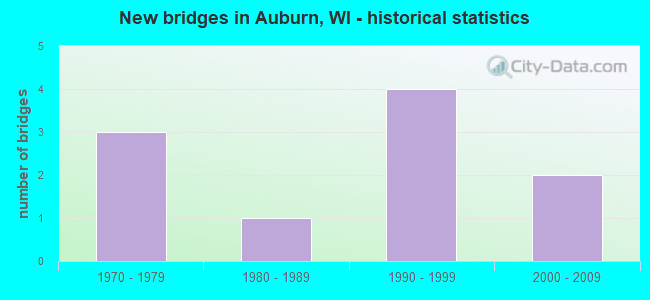
- New bridges - historical statistics
- 31970-1979
- 11980-1989
- 41990-1999
- 22000-2009
FCC Registered Antenna Towers:
16 (See the full list of FCC Registered Antenna Towers in Auburn)FCC Registered Microwave Towers:
1- Auburn Township, 500 Ft N Of Jct County Trunk Hwy Q And Blackberry Rd (Lat: 45.165778 Lon: -91.563750), Type: Pole, Structure height: 18.9 m, Call Sign: WNTQ803,
Assigned Frequencies: 954.000 MHz, Grant Date: 11/07/2017, Expiration Date: 01/26/2028, Registrant: Communications, 1712 River Lakes Rd, Oconomowoc, WI 53066, Phone: (920) 210-4455, Email:
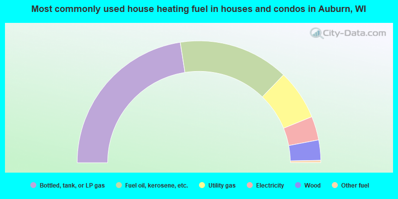
- 45.1%Bottled, tank, or LP gas
- 29.3%Fuel oil, kerosene, etc.
- 13.3%Utility gas
- 6.3%Electricity
- 5.4%Wood
- 0.6%Other fuel
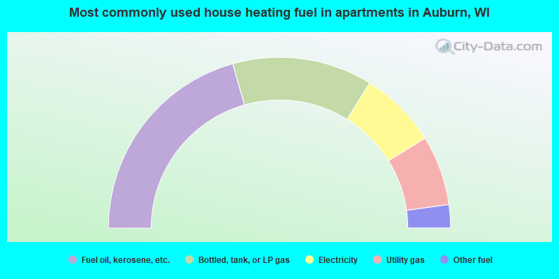
- 41.2%Fuel oil, kerosene, etc.
- 26.5%Bottled, tank, or LP gas
- 14.7%Electricity
- 13.2%Utility gas
- 4.4%Other fuel
Auburn compared to Wisconsin state average:
- Unemployed percentage below state average.
- Black race population percentage significantly below state average.
- Hispanic race population percentage significantly below state average.
- Foreign-born population percentage significantly below state average.
- Renting percentage significantly below state average.
- Length of stay since moving in significantly above state average.
- Number of rooms per house significantly below state average.
- House age significantly below state average.
- Percentage of population with a bachelor's degree or higher significantly below state average.