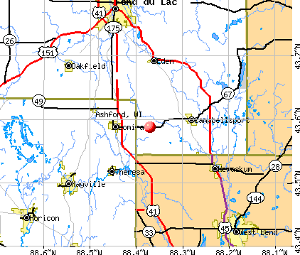
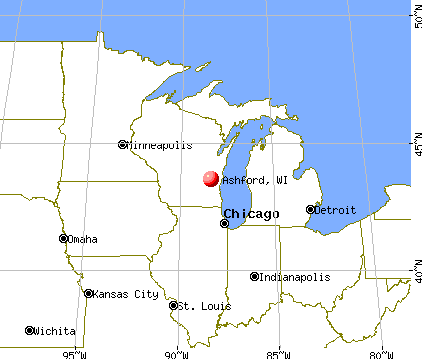
Ashford, Wisconsin
Submit your own pictures of this town and show them to the world
- OSM Map
- General Map
- Google Map
- MSN Map
Population change since 2000: -1.5%
 |
| Males: 881 | |
| Females: 866 |
| Median resident age: | 45.0 years |
| Wisconsin median age: | 42.6 years |
Zip codes: 53010.
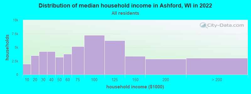
| Ashford: | $77,821 |
| WI: | $70,996 |
Estimated per capita income in 2022: $40,337 (it was $21,777 in 2000)
Ashford town income, earnings, and wages data
Estimated median house or condo value in 2022: $288,722 (it was $132,200 in 2000)
| Ashford: | $288,722 |
| WI: | $252,800 |
Mean prices in 2022: all housing units: $253,446; detached houses: $264,898; townhouses or other attached units: $220,861; in 2-unit structures: $156,740; in 3-to-4-unit structures: $141,668; in 5-or-more-unit structures: $118,941; mobile homes: $48,221
Detailed information about poverty and poor residents in Ashford, WI


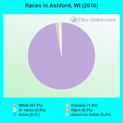
- 1,69697.1%White alone
- 241.4%Hispanic
- 100.6%Two or more races
- 60.3%Black alone
- 60.3%Asian alone
- 40.2%American Indian alone
- 10.06%Other race alone
Races in Ashford detailed stats: ancestries, foreign born residents, place of birth
 Recent articles from our blog. Our writers, many of them Ph.D. graduates or candidates, create easy-to-read articles on a wide variety of topics.

 | medicine wheel (0 replies) |
| Moving to Appleton; Need dog freindly apt (11 replies) |
Latest news from Ashford, WI collected exclusively by city-data.com from local newspapers, TV, and radio stations
Ancestries: German (67.1%), Irish (9.1%), English (4.4%), Polish (4.4%), United States (3.9%), French (3.2%).
Current Local Time: CST time zone
Elevation: 1050 feet
Land area: 35.8 square miles.
Population density: 49 people per square mile (very low).
26 residents are foreign born
| This town: | 1.5% |
| Wisconsin: | 3.6% |
| Ashford town: | 1.3% ($1,756) |
| Wisconsin: | 2.0% ($2,245) |
Nearest city with pop. 50,000+: Sheboygan, WI  (32.6 miles , pop. 50,792).
Nearest city with pop. 200,000+: Milwaukee, WI (40.8 miles , pop. 596,974).
Nearest city with pop. 1,000,000+: Chicago, IL (124.5 miles , pop. 2,896,016).
Nearest cities:
), ), ), )Latitude: 43.58 N, Longitude: 88.33 W
Area code commonly used in this area: 920

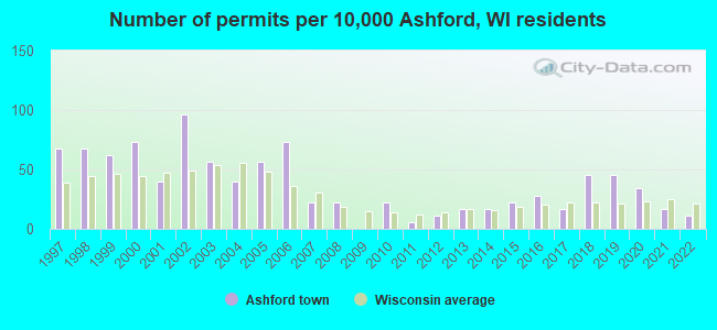
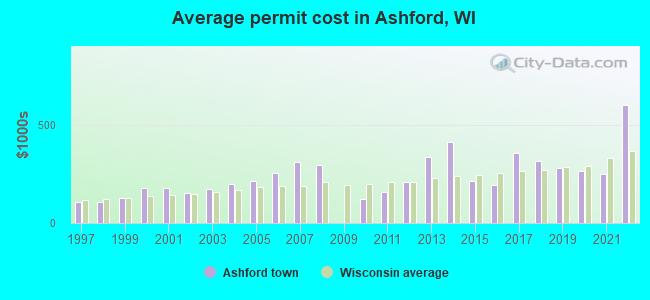
Single-family new house construction building permits:
- 2022: 2 buildings, average cost: $600,000
- 2021: 3 buildings, average cost: $246,700
- 2020: 6 buildings, average cost: $264,900
- 2019: 8 buildings, average cost: $281,900
- 2018: 8 buildings, average cost: $314,100
- 2017: 3 buildings, average cost: $353,600
- 2016: 5 buildings, average cost: $192,800
- 2015: 4 buildings, average cost: $213,100
- 2014: 3 buildings, average cost: $413,300
- 2013: 3 buildings, average cost: $335,000
- 2012: 2 buildings, average cost: $207,500
- 2011: 1 building, cost: $160,000
- 2010: 4 buildings, average cost: $121,000
- 2008: 4 buildings, average cost: $292,500
- 2007: 4 buildings, average cost: $308,800
- 2006: 13 buildings, average cost: $252,100
- 2005: 10 buildings, average cost: $212,100
- 2004: 7 buildings, average cost: $198,500
- 2003: 10 buildings, average cost: $172,000
- 2002: 17 buildings, average cost: $150,700
- 2001: 7 buildings, average cost: $178,400
- 2000: 13 buildings, average cost: $180,200
- 1999: 11 buildings, average cost: $129,200
- 1998: 12 buildings, average cost: $107,900
- 1997: 12 buildings, average cost: $106,600
| Here: | 2.2% |
| Wisconsin: | 2.7% |
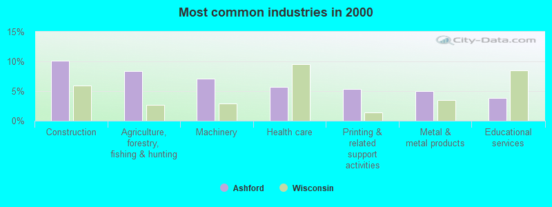
- Construction (10.1%)
- Agriculture, forestry, fishing & hunting (8.4%)
- Machinery (7.1%)
- Health care (5.6%)
- Printing & related support activities (5.4%)
- Metal & metal products (5.1%)
- Educational services (3.8%)
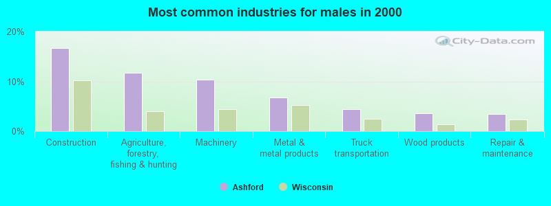
- Construction (16.8%)
- Agriculture, forestry, fishing & hunting (11.7%)
- Machinery (10.4%)
- Metal & metal products (6.7%)
- Truck transportation (4.4%)
- Wood products (3.6%)
- Repair & maintenance (3.5%)
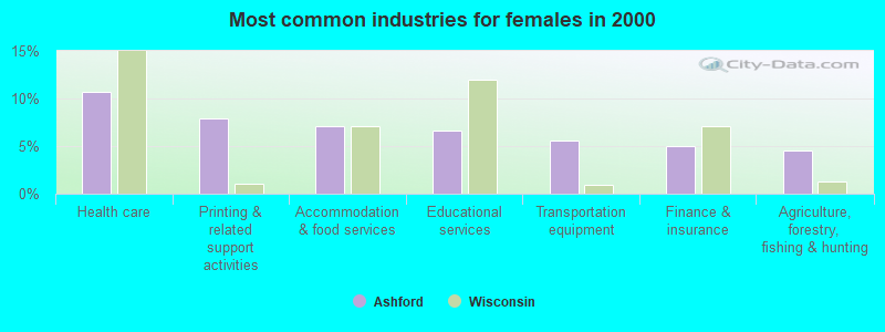
- Health care (10.6%)
- Printing & related support activities (7.9%)
- Accommodation & food services (7.1%)
- Educational services (6.7%)
- Transportation equipment (5.6%)
- Finance & insurance (5.0%)
- Agriculture, forestry, fishing & hunting (4.6%)
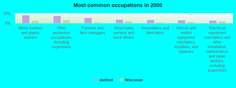
- Metal workers and plastic workers (8.5%)
- Other production occupations, including supervisors (8.0%)
- Farmers and farm managers (5.8%)
- Driver/sales workers and truck drivers (3.8%)
- Assemblers and fabricators (3.6%)
- Vehicle and mobile equipment mechanics, installers, and repairers (3.3%)
- Electrical equipment mechanics and other installation, maintenance, and repair workers, including supervisors (3.0%)
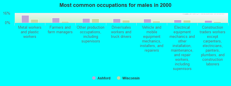
- Metal workers and plastic workers (12.6%)
- Farmers and farm managers (8.0%)
- Other production occupations, including supervisors (7.1%)
- Driver/sales workers and truck drivers (6.6%)
- Vehicle and mobile equipment mechanics, installers, and repairers (6.2%)
- Electrical equipment mechanics and other installation, maintenance, and repair workers, including supervisors (4.9%)
- Construction traders workers except carpenters, electricians, painters, plumbers, and construction laborers (4.0%)
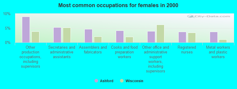
- Other production occupations, including supervisors (9.0%)
- Secretaries and administrative assistants (5.2%)
- Assemblers and fabricators (4.6%)
- Cooks and food preparation workers (4.2%)
- Other office and administrative support workers, including supervisors (4.0%)
- Registered nurses (3.8%)
- Metal workers and plastic workers (3.8%)
Average climate in Ashford, Wisconsin
Based on data reported by over 4,000 weather stations


(lower is better)
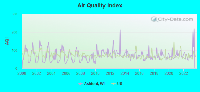
Air Quality Index (AQI) level in 2022 was 66.1. This is about average.
| City: | 66.1 |
| U.S.: | 72.6 |
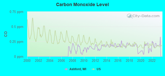
Carbon Monoxide (CO) [ppm] level in 2022 was 0.198. This is better than average. Closest monitor was 13.9 miles away from the city center.
| City: | 0.198 |
| U.S.: | 0.251 |
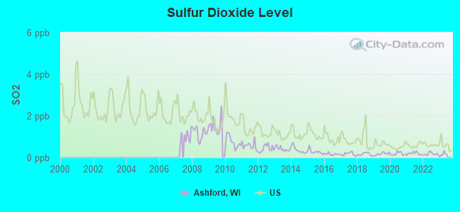
Sulfur Dioxide (SO2) [ppb] level in 2022 was 0.173. This is significantly better than average. Closest monitor was 12.0 miles away from the city center.
| City: | 0.173 |
| U.S.: | 1.515 |
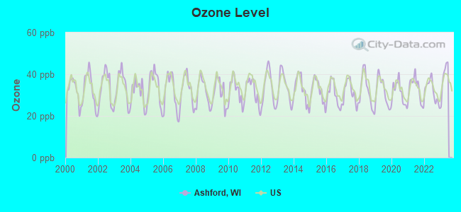
Ozone [ppb] level in 2022 was 31.9. This is about average. Closest monitor was 13.5 miles away from the city center.
| City: | 31.9 |
| U.S.: | 33.3 |
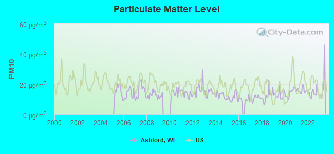
Particulate Matter (PM10) [µg/m3] level in 2022 was 14.1. This is better than average. Closest monitor was 13.9 miles away from the city center.
| City: | 14.1 |
| U.S.: | 19.2 |
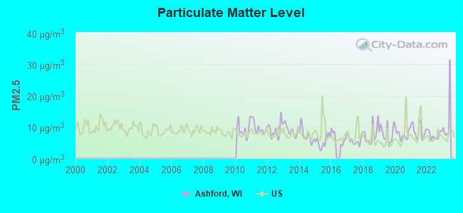
Particulate Matter (PM2.5) [µg/m3] level in 2022 was 7.50. This is about average. Closest monitor was 13.9 miles away from the city center.
| City: | 7.50 |
| U.S.: | 8.11 |
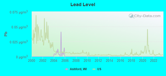
Lead (Pb) [µg/m3] level in 2005 was 0.0105. This is about average. Closest monitor was 13.9 miles away from the city center.
| City: | 0.0105 |
| U.S.: | 0.0093 |
Tornado activity:
Ashford-area historical tornado activity is slightly above Wisconsin state average. It is 45% greater than the overall U.S. average.
On 7/18/1996, a category F5 (max. wind speeds 261-318 mph) tornado 10.3 miles away from the Ashford town center injured 12 people and caused $40 million in damages.
On 4/4/1981, a category F4 (max. wind speeds 207-260 mph) tornado 12.0 miles away from the town center killed 3 people and injured 53 people and caused between $5,000,000 and $50,000,000 in damages.
Earthquake activity:
Ashford-area historical earthquake activity is significantly above Wisconsin state average. It is 3% greater than the overall U.S. average.On 4/18/2008 at 09:36:59, a magnitude 5.4 (5.1 MB, 4.8 MS, 5.4 MW, 5.2 MW, Class: Moderate, Intensity: VI - VII) earthquake occurred 355.2 miles away from Ashford center
On 6/28/2004 at 06:10:52, a magnitude 4.2 (4.2 MW, Depth: 6.2 mi, Class: Light, Intensity: IV - V) earthquake occurred 149.2 miles away from Ashford center
On 6/10/1987 at 23:48:54, a magnitude 5.1 (4.9 MB, 4.4 MS, 4.6 MS, 5.1 LG) earthquake occurred 329.7 miles away from Ashford center
On 5/2/2015 at 16:23:07, a magnitude 4.2 (4.2 MW, Depth: 2.8 mi) earthquake occurred 173.8 miles away from the city center
On 4/18/2008 at 09:36:59, a magnitude 5.2 (5.2 MW, Depth: 8.9 mi) earthquake occurred 355.2 miles away from Ashford center
On 2/10/2010 at 09:59:35, a magnitude 3.8 (3.8 MW, Depth: 6.2 mi, Class: Light, Intensity: II - III) earthquake occurred 111.5 miles away from the city center
Magnitude types: regional Lg-wave magnitude (LG), body-wave magnitude (MB), surface-wave magnitude (MS), moment magnitude (MW)
Natural disasters:
The number of natural disasters in Fond du Lac County (11) is smaller than the US average (15).Major Disasters (Presidential) Declared: 8
Emergencies Declared: 2
Causes of natural disasters: Floods: 7, Storms: 6, Tornadoes: 4, Winds: 2, Drought: 1, Hurricane: 1, Landslide: 1, Other: 1 (Note: some incidents may be assigned to more than one category).
Hospitals and medical centers near Ashford:
- HOPE HEALTH AND REHAB (Nursing Home, about 6 miles away; LOMIRA, WI)
- HOPE NURSING HOME INC (Nursing Home, about 6 miles away; LOMIRA, WI)
- SAMARITAN HEALTH CENTER (Nursing Home, about 13 miles away; WEST BEND, WI)
- MAYVILLE NUR REHAB CTR (Nursing Home, about 13 miles away; MAYVILLE, WI)
- GENERATIONS HOME HEALTHCARE INC (Home Health Center, about 14 miles away; FOND DU LAC, WI)
- CEDAR COMMUNITY HOME HEALTH AGENCY (Home Health Center, about 14 miles away; WEST BEND, WI)
- HEARTLAND HHC AND HSPC (Home Health Center, about 14 miles away; FOND DU LAC, WI)
Colleges/universities with over 2000 students nearest to Ashford:
- Marian University (about 15 miles; Fond Du Lac, WI; Full-time enrollment: 2,045)
- Moraine Park Technical College (about 16 miles; Fond du Lac, WI; FT enrollment: 3,079)
- Lakeland College (about 29 miles; Plymouth, WI; FT enrollment: 2,395)
- Concordia University-Wisconsin (about 31 miles; Mequon, WI; FT enrollment: 5,253)
- University of Wisconsin-Oshkosh (about 33 miles; Oshkosh, WI; FT enrollment: 10,637)
- Waukesha County Technical College (about 36 miles; Pewaukee, WI; FT enrollment: 4,415)
- Cardinal Stritch University (about 37 miles; Milwaukee, WI; FT enrollment: 3,595)
Points of interest:
Notable location: Golden Corners (A). Display/hide its location on the map
Church in Ashford: Saint Martins Church (A). Display/hide its location on the map
Cemeteries: Rauch Cemetery (1), Deutsche Bisch Cemetery (2), Saint Killian Cemetery (3), Saint Martins Cemetery (4), Elmore Cemetery (5), Gudex Cemetery (6). Display/hide their locations on the map
Lakes and reservoirs: Senn Lake (A), Lake Bernice (B), Bernice Lake 31 (C). Display/hide their locations on the map
| This town: | 2.5 people |
| Wisconsin: | 2.4 people |
| This town: | 73.0% |
| Whole state: | 64.4% |
| This town: | 6.6% |
| Whole state: | 7.3% |
Likely homosexual households (counted as self-reported same-sex unmarried-partner households)
- Lesbian couples: 0.4% of all households
- Gay men: 0.1% of all households
| This town: | 3.0% |
| Whole state: | 8.7% |
| This town: | 1.1% |
| Whole state: | 3.7% |
For population 15 years and over in Ashford:
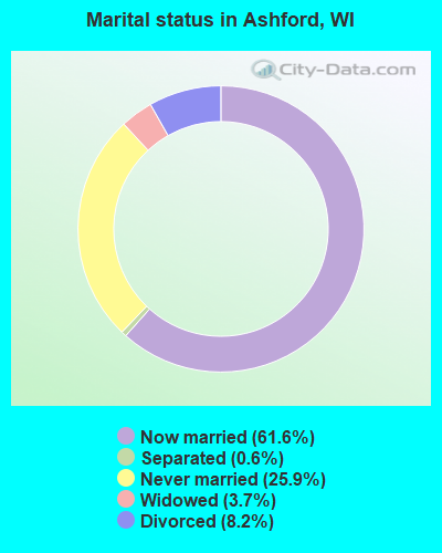
- Never married: 25.9%
- Now married: 61.6%
- Separated: 0.6%
- Widowed: 3.7%
- Divorced: 8.2%
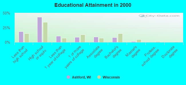
For population 25 years and over in Ashford:
- High school or higher: 81.4%
- Bachelor's degree or higher: 9.7%
- Graduate or professional degree: 1.6%
- Unemployed: 3.9%
- Mean travel time to work (commute): 24.9 minutes
| Here: | 9.2 |
| Wisconsin average: | 11.0 |
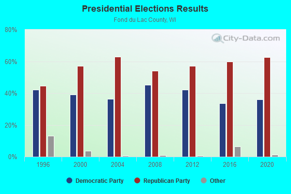
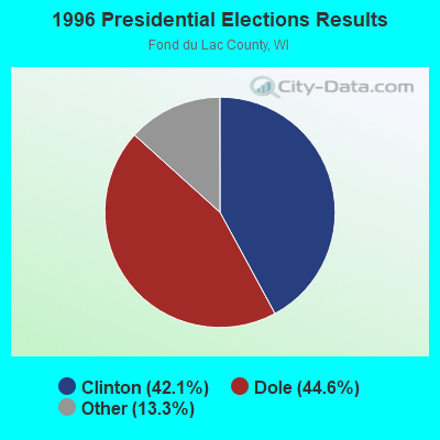
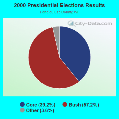
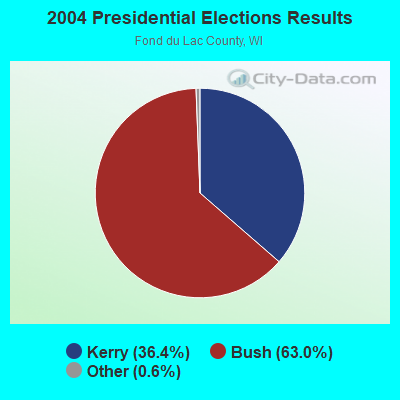
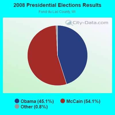
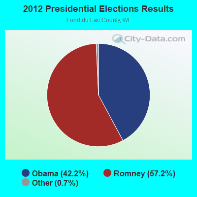
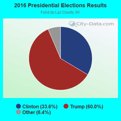
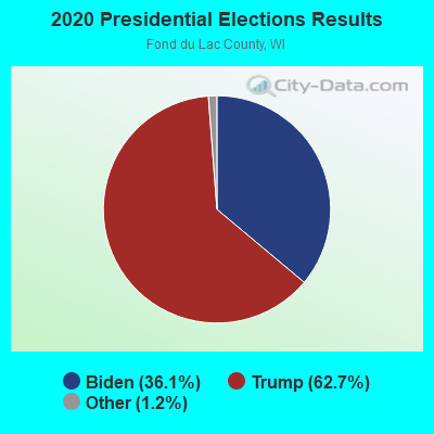
Graphs represent county-level data. Detailed 2008 Election Results
Religion statistics for Ashford, WI (based on Fond du Lac County data)
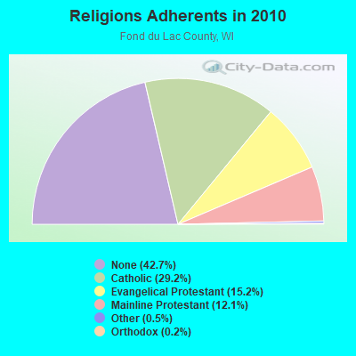
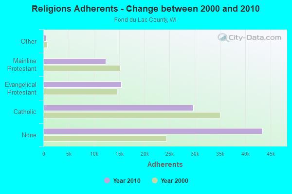
| Religion | Adherents | Congregations |
|---|---|---|
| Catholic | 29,714 | 15 |
| Evangelical Protestant | 15,457 | 44 |
| Mainline Protestant | 12,339 | 32 |
| Other | 500 | 6 |
| Orthodox | 220 | 1 |
| None | 43,403 | - |
Food Environment Statistics:
| Fond du Lac County: | 1.21 / 10,000 pop. |
| Wisconsin: | 1.86 / 10,000 pop. |
| Fond du Lac County: | 4.64 / 10,000 pop. |
| State: | 4.12 / 10,000 pop. |
| This county: | 7.37 / 10,000 pop. |
| Wisconsin: | 8.64 / 10,000 pop. |
| Here: | 7.5% |
| Wisconsin: | 7.6% |
| Here: | 28.4% |
| Wisconsin: | 27.5% |
| This county: | 8.9% |
| Wisconsin: | 13.0% |
Strongest AM radio stations in Ashford:
- WNAM (1280 AM; 50 kW; NEENAH-MENASHA, WI; Owner: CUMULUS LICENSING CORP.)
- WTMJ (620 AM; 50 kW; MILWAUKEE, WI; Owner: JOURNAL BROADCAST CORPORATION)
- WHBY (1150 AM; 25 kW; KIMBERLY, WI; Owner: WOODWARD COMMUNICATIONS, INC.)
- WISN (1130 AM; 50 kW; MILWAUKEE, WI; Owner: CAPSTAR TX LIMITED PARTNERSHIP)
- WBKV (1470 AM; 2 kW; WEST BEND, WI; Owner: WEST BEND BROADCASTING CO.)
- WSPT (1010 AM; 50 kW; STEVENS POINT, WI)
- WGN (720 AM; 50 kW; CHICAGO, IL; Owner: WGN CONTINENTAL BROADCASTING CO.)
- WSCR (670 AM; 50 kW; CHICAGO, IL; Owner: INFINITY BROADCASTING OPERATIONS, INC.)
- WKSH (1640 AM; 10 kW; SUSSEX, WI; Owner: ABC, INC.)
- WBBM (780 AM; 50 kW; CHICAGO, IL; Owner: INFINITY BROADCASTING OPERATIONS, INC.)
- WAUK (1510 AM; daytime; 10 kW; WAUKESHA, WI; Owner: WALT-WEST WISCONSIN, INC.)
- WHBL (1330 AM; 5 kW; SHEBOYGAN, WI; Owner: MIDWEST COMMUNICATIONS, INC.)
- WRPN (1600 AM; 5 kW; RIPON, WI)
Strongest FM radio stations in Ashford:
- WBWI-FM (92.5 FM; WEST BEND, WI; Owner: WEST BEND BROADCASTING CO.)
- WFDL-FM (97.7 FM; LOMIRA, WI; Owner: RADIO PLUS OF FOND DU LAC, INC.)
- WSTM (91.3 FM; KIEL, WI; Owner: JUBILATION MINISTRIES INC)
- WMDC (98.7 FM; MAYVILLE, WI; Owner: RADIO PLUS, INC.)
- WXER (104.5 FM; PLYMOUTH, WI; Owner: RBH ENTERPRISES, INC. D/B/A YELLOW DOG BROADCASTING)
- WMIL-FM (106.1 FM; WAUKESHA, WI; Owner: CLEAR CHANNEL BROADCASTING LICENSES, INC.)
- WJZI (93.3 FM; MILWAUKEE, WI; Owner: MILWAUKEE RADIO ALLIANCE, LLC)
- WLTQ (97.3 FM; MILWAUKEE, WI; Owner: CAPSTAR TX LIMITED PARTNERSHIP)
- WKTI-FM (94.5 FM; MILWAUKEE, WI; Owner: JOURNAL BROADCAST CORPORATION)
- WAPL-FM (105.7 FM; APPLETON, WI; Owner: WOODWARD COMMUNICATIONS, INC.)
- WUWM (89.7 FM; MILWAUKEE, WI; Owner: BOARD OF REGENTS, UNIVERSITY OF WISCONSIN SYSTEM)
- WXSS (103.7 FM; WAUWATOSA, WI; Owner: ENTERCOM MILWAUKEE LICENSE, LLC)
- KFIZ-FM (107.1 FM; FOND DU LAC, WI; Owner: RBH ENTERPRISES, INC.)
- WKLH (96.5 FM; MILWAUKEE, WI; Owner: LAKEFRONT COMMUNICATIONS, LLC)
- WTCX (96.1 FM; RIPON, WI; Owner: RADIO B/C LTD PARTNERSHIP)
- WTKM-FM (104.9 FM; HARTFORD, WI; Owner: KETTLE MORAINE B/CTING COMPANY, INC.)
- WGLB-FM (100.1 FM; PORT WASHINGTON, WI; Owner: STARBOARD MEDIA FOUNDATION, INC.)
- W236AG (95.1 FM; FOND DU LAC, WI; Owner: FAMILY EDUCATION BROADCASTING CORP.)
TV broadcast stations around Ashford:
- WWRS-TV (Channel 52; MAYVILLE, WI; Owner: NATIONAL MINORITY T.V., INC.)
- WMMF-TV (Channel 68; FOND DU LAC, WI; Owner: PAPPAS TELECASTING OF WISCONSIN, A CALIFORNIA LTD PARTNRSHP)
- WITI (Channel 6; MILWAUKEE, WI; Owner: WITI LICENSE,INC.)
- WDJT-TV (Channel 58; MILWAUKEE, WI; Owner: WDJT-TV LIMITED PARTNERSHIP)
- WISN-TV (Channel 12; MILWAUKEE, WI; Owner: WISN HEARST-ARGYLE TV, INC. (CA CORP.))
- WPXE (Channel 55; KENOSHA, WI; Owner: PAXSON MILWAUKEE LICENSE, INC.)
- WMVS (Channel 10; MILWAUKEE, WI; Owner: MILWAUKEE AREA TECHNICAL COLLEGE DISTRICT BOARD)
- WMVT (Channel 36; MILWAUKEE, WI; Owner: MILWAUKEE AREA TECHNICAL COLLEGE DISTRICT BOARD)
- WMLW-CA (Channel 46; MILWAUKEE, WI; Owner: CHANNEL 41 AND 63 LIMITED PARTNERSHIP)
- W63CU (Channel 63; MILWAUKEE, WI; Owner: CHANNEL 41 AND 63 LIMITED PARTNERSHIP)
- WCGV-TV (Channel 24; MILWAUKEE, WI; Owner: WCGV LICENSEE, LLC)
- WVTV (Channel 18; MILWAUKEE, WI; Owner: WVTV LICENSEE, INC.)
- WTMJ-TV (Channel 4; MILWAUKEE, WI; Owner: JOURNAL BROADCAST CORPORATION)
- WVCY-TV (Channel 30; MILWAUKEE, WI; Owner: VCY AMERICA, INC.)
- National Bridge Inventory (NBI) Statistics
- 12Number of bridges
- 56ft / 17.3mTotal length
- $363,000Total costs
- 4,139Total average daily traffic
- 15Total average daily truck traffic
- 4,555Total future (year 2039) average daily traffic

- New bridges - historical statistics
- 11920-1929
- 11930-1939
- 21940-1949
- 11960-1969
- 11970-1979
- 41980-1989
- 12000-2009
- 12020-2022
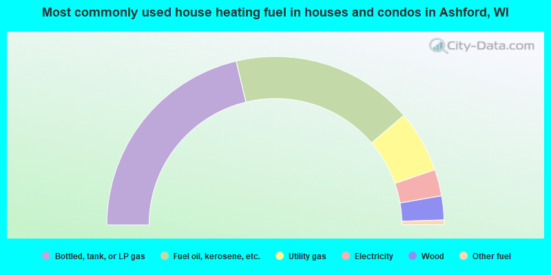
- 42.5%Bottled, tank, or LP gas
- 35.0%Fuel oil, kerosene, etc.
- 11.9%Utility gas
- 5.1%Electricity
- 4.6%Wood
- 0.9%Other fuel
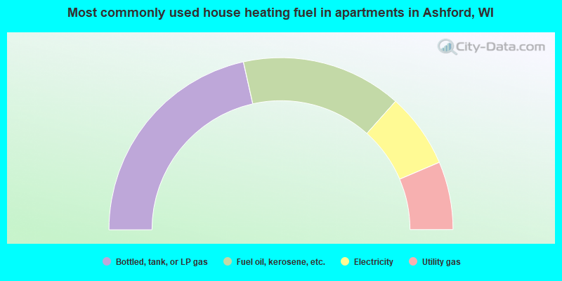
- 43.0%Bottled, tank, or LP gas
- 30.2%Fuel oil, kerosene, etc.
- 14.0%Electricity
- 12.8%Utility gas
Ashford compared to Wisconsin state average:
- Unemployed percentage significantly below state average.
- Black race population percentage significantly below state average.
- Hispanic race population percentage significantly below state average.
- Foreign-born population percentage significantly below state average.
- Renting percentage significantly below state average.
- Length of stay since moving in significantly above state average.
- Number of rooms per house significantly below state average.
- House age significantly below state average.
- Percentage of population with a bachelor's degree or higher significantly below state average.