Barton, Wisconsin
Submit your own pictures of this town and show them to the world
- OSM Map
- General Map
- Google Map
- MSN Map

Population change since 2000: +3.6%
 |
| Males: 1,365 | |
| Females: 1,272 |
| Median resident age: | 46.8 years |
| Wisconsin median age: | 42.6 years |
Zip codes: 53090.
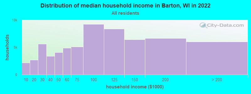
| Barton: | $100,996 |
| WI: | $70,996 |
Estimated per capita income in 2022: $47,540 (it was $26,039 in 2000)
Barton town income, earnings, and wages data
Estimated median house or condo value in 2022: $332,794 (it was $161,800 in 2000)
| Barton: | $332,794 |
| WI: | $252,800 |
Mean prices in 2022: all housing units: $365,194; detached houses: $394,485; townhouses or other attached units: $248,976; in 2-unit structures: $202,569; in 3-to-4-unit structures: $190,719; in 5-or-more-unit structures: $169,378; mobile homes: $84,115
Detailed information about poverty and poor residents in Barton, WI
Compare current foreclosures near Barton, WI:
| Photo | Address | Area | Beds / Baths | Price | Details |
|---|---|---|---|---|---|

|
#1
Wheelock Ave
Hartford, WI 53027
|
1,532 sq. feet
|
2 baths 4 beds |
$339,900
|
show details |

|
#2
Raven St
West Bend, WI 53090
|
1,650 sq. feet
|
1 baths 4 beds |
show details | |

|
#3
Creekwood Ln
West Bend, WI 53095
|
1,780 sq. feet
|
2 baths 3 beds |
show details | |

|
#4
High St
West Bend, WI 53090
|
1,400 sq. feet
|
1 baths 3 beds |
show details | |

|
#5
S Indiana Ave
West Bend, WI 53095
|
1,066 sq. feet
|
1 baths 3 beds |
show details | |

|
#6
Arbor Vitae Dr
West Bend, WI 53095
|
- sq. feet
|
2 baths 3 beds |
show details | |

|
#7
Creekside Pl
West Bend, WI 53095
|
2,822 sq. feet
|
2 baths 4 beds |
show details | |

|
#8
Edgewater Dr
West Bend, WI 53095
|
2,230 sq. feet
|
2 baths 4 beds |
show details | |

|
#9
Clarence Ct Apt 5
West Bend, WI 53095
|
1,204 sq. feet
|
1 baths 2 beds |
show details | |

|
#10
Birchwood Dr
West Bend, WI 53095
|
864 sq. feet
|
1 baths 3 beds |
show details |
| Photo | Address | Area | Beds / Baths | Price | Details |
|---|---|---|---|---|---|

|
#11
Terrace Dr
West Bend, WI 53095
|
1,245 sq. feet
|
1 baths 3 beds |
show details | |

|
#12
S Main St
West Bend, WI 53095
|
1,560 sq. feet
|
2 baths 3 beds |
show details | |

|
#13
Goldenrod Cir
West Bend, WI 53095
|
1,406 sq. feet
|
2 baths 3 beds |
show details | |

|
#14
N 18th Ave
West Bend, WI 53090
|
1,685 sq. feet
|
2 baths 4 beds |
show details | |

|
#15
Miller St
West Bend, WI 53095
|
1,081 sq. feet
|
1 baths 2 beds |
show details | |

|
#16
N University Dr Unit 123
West Bend, WI 53095
|
1,145 sq. feet
|
2 baths 2 beds |
show details | |

|
#17
Hans St
West Bend, WI 53090
|
1,324 sq. feet
|
2 baths 3 beds |
show details | |

|
#18
Green Tree Rd
West Bend, WI 53090
|
1,064 sq. feet
|
1 baths 2 beds |
show details | |

|
#19
Cherry St
West Bend, WI 53090
|
1,484 sq. feet
|
2 baths 4 beds |
show details | |

|
#20
Dubin Cir
West Bend, WI 53090
|
2,028 sq. feet
|
3 baths 3 beds |
show details |
| Photo | Address | Area | Beds / Baths | Price | Details |
|---|---|---|---|---|---|

|
#21
Larkspur Ln
West Bend, WI 53090
|
2,284 sq. feet
|
2 baths 3 beds |
show details | |

|
#22
Wayne Rd
West Bend, WI 53090
|
1,378 sq. feet
|
2 baths 3 beds |
show details | |

|
#23
Kettle Ct
West Bend, WI 53090
|
3,792 sq. feet
|
3 baths 4 beds |
show details | |

|
#24
Squire Ln
West Bend, WI 53090
|
1,966 sq. feet
|
2 baths 3 beds |
show details | |

|
#25
Grant Pl
West Bend, WI 53090
|
1,318 sq. feet
|
2 baths 3 beds |
show details | |

|
#26
N Salisbury Rd
West Bend, WI 53090
|
802 sq. feet
|
1 baths 2 beds |
show details | |

|
#27
Minz Park Cir Apt 4
West Bend, WI 53095
|
1,098 sq. feet
|
1 baths 2 beds |
show details | |

|
#28
Main St
Germantown, WI 53022
|
- sq. feet
|
- baths - beds |
show details | |

|
#29
Meadowbrook Park Dr
Iron Ridge, WI 53035
|
- sq. feet
|
- baths - beds |
show details | |

|
#30
S Milwaukee St
Fredonia, WI 53021
|
- sq. feet
|
- baths - beds |
show details |
| Photo | Address | Area | Beds / Baths | Price | Details |
|---|---|---|---|---|---|

|
#31
S German St
Mayville, WI 53050
|
- sq. feet
|
- baths - beds |
show details | |

|
#32
Pierce Rd
Mayville, WI 53050
|
- sq. feet
|
- baths - beds |
show details | |

|
#33
Falls Rd # 665
Grafton, WI 53024
|
- sq. feet
|
- baths - beds |
show details | |

|
#34
N Main St Apt 212
Hartford, WI 53027
|
- sq. feet
|
- baths - beds |
show details | |

|
#35
German St
Mayville, WI 53050
|
- sq. feet
|
- baths - beds |
show details | |

|
#36
E Monroe Ave # 9
Hartford, WI 53027
|
- sq. feet
|
- baths - beds |
show details | |

|
#37
Biscayne Dr
Germantown, WI 53022
|
- sq. feet
|
- baths - beds |
show details | |

|
#38
E Loos St # 7
Hartford, WI 53027
|
- sq. feet
|
- baths - beds |
show details | |

|
#39
Pleasant Ave Apt 2
Hartford, WI 53027
|
- sq. feet
|
- baths - beds |
show details | |

|
#40
Windsor Ct
Germantown, WI 53022
|
- sq. feet
|
- baths - beds |
show details |
| Photo | Address | Area | Beds / Baths | Price | Details |
|---|---|---|---|---|---|

|
#41
E Monroe Ave
Hartford, WI 53027
|
- sq. feet
|
- baths - beds |
show details | |

|
#42
Harker Ave Apt 6
Hartford, WI 53027
|
- sq. feet
|
- baths - beds |
show details | |

|
#43
Lois Ct
Hartford, WI 53027
|
- sq. feet
|
- baths - beds |
show details | |

|
#44
Royal Ct
Germantown, WI 53022
|
- sq. feet
|
- baths - beds |
show details | |

|
#45
N Main St # 5
Hartford, WI 53027
|
- sq. feet
|
- baths - beds |
show details | |

|
#46
S Milwaukee St
Theresa, WI 53091
|
- sq. feet
|
- baths - beds |
show details | |

|
#47
17th Ave
Grafton, WI 53024
|
- sq. feet
|
- baths - beds |
show details | |

|
#48
Novak St
Hartford, WI 53027
|
- sq. feet
|
- baths - beds |
show details | |

|
#49
Linden Ave
Hartford, WI 53027
|
- sq. feet
|
- baths - beds |
show details | |

|
Check over 1 million property listings on Foreclosure.com!
|
browse all offers | |||

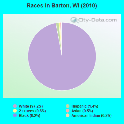
- 2,56397.2%White alone
- 361.4%Hispanic
- 160.6%Two or more races
- 120.5%Asian alone
- 50.2%Black alone
- 50.2%American Indian alone
Races in Barton detailed stats: ancestries, foreign born residents, place of birth
 Recent articles from our blog. Our writers, many of them Ph.D. graduates or candidates, create easy-to-read articles on a wide variety of topics.

 | Where are all the kids??? Please HELP!!! (35 replies) |
Latest news from Barton, WI collected exclusively by city-data.com from local newspapers, TV, and radio stations
Ancestries: German (67.6%), Polish (11.6%), Irish (7.2%), French (5.3%), French Canadian (2.7%), English (2.4%).
Current Local Time: CST time zone
Elevation: 950 feet
Land area: 19.2 square miles.
Population density: 137 people per square mile (very low).
| Barton town: | 1.4% ($2,295) |
| Wisconsin: | 2.0% ($2,245) |
Nearest city with pop. 50,000+: Milwaukee, WI  (30.7 miles , pop. 596,974).
Nearest city with pop. 1,000,000+: Chicago, IL (114.9 miles , pop. 2,896,016).
Nearest cities:
), ), ), ), )Latitude: 43.45 N, Longitude: 88.22 W
Area code commonly used in this area: 262

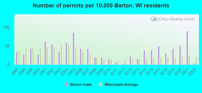
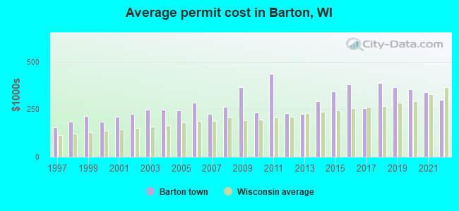
Single-family new house construction building permits:
- 2022: 1 building, cost: $300,000
- 2021: 23 buildings, average cost: $340,900
- 2020: 13 buildings, average cost: $354,500
- 2019: 11 buildings, average cost: $366,000
- 2018: 8 buildings, average cost: $389,000
- 2017: 13 buildings, average cost: $256,500
- 2016: 10 buildings, average cost: $382,200
- 2015: 10 buildings, average cost: $343,700
- 2014: 4 buildings, average cost: $293,800
- 2013: 6 buildings, average cost: $226,700
- 2012: 1 building, cost: $230,000
- 2011: 2 buildings, average cost: $437,500
- 2010: 4 buildings, average cost: $233,800
- 2009: 5 buildings, average cost: $367,000
- 2008: 5 buildings, average cost: $263,400
- 2007: 11 buildings, average cost: $226,200
- 2006: 11 buildings, average cost: $286,000
- 2005: 22 buildings, average cost: $243,600
- 2004: 15 buildings, average cost: $248,900
- 2003: 9 buildings, average cost: $247,600
- 2002: 14 buildings, average cost: $226,700
- 2001: 16 buildings, average cost: $209,500
- 2000: 7 buildings, average cost: $186,000
- 1999: 11 buildings, average cost: $214,500
- 1998: 7 buildings, average cost: $184,400
- 1997: 9 buildings, average cost: $156,200
| Here: | 2.2% |
| Wisconsin: | 2.7% |
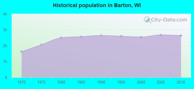
Population change in the 1990s: +19 (+0.8%).
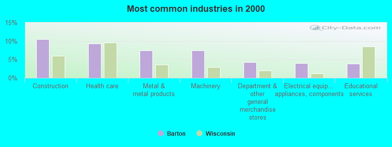
- Construction (10.4%)
- Health care (9.3%)
- Metal & metal products (7.5%)
- Machinery (7.4%)
- Department & other general merchandise stores (4.3%)
- Electrical equipment, appliances, components (4.0%)
- Educational services (3.9%)
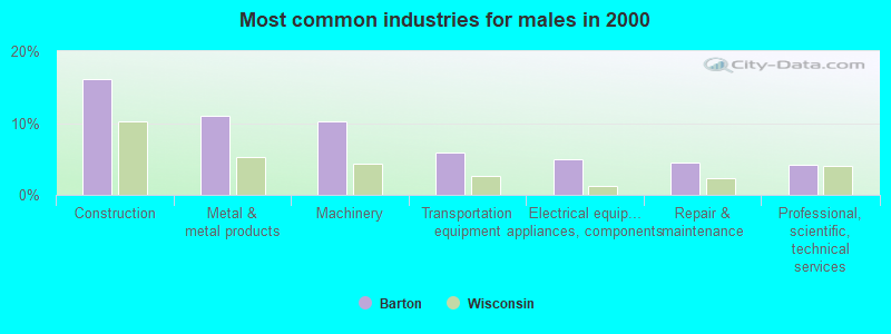
- Construction (16.1%)
- Metal & metal products (11.0%)
- Machinery (10.2%)
- Transportation equipment (5.9%)
- Electrical equipment, appliances, components (5.0%)
- Repair & maintenance (4.5%)
- Professional, scientific, technical services (4.2%)
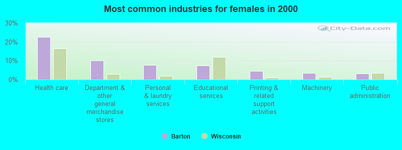
- Health care (22.6%)
- Department & other general merchandise stores (10.0%)
- Personal & laundry services (7.6%)
- Educational services (7.5%)
- Printing & related support activities (4.5%)
- Machinery (3.4%)
- Public administration (3.3%)
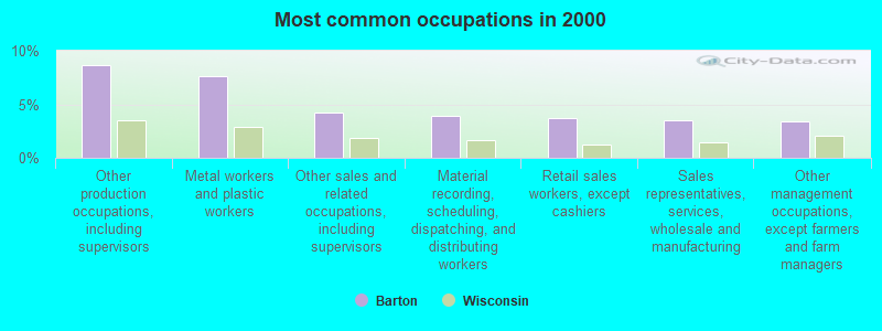
- Other production occupations, including supervisors (8.7%)
- Metal workers and plastic workers (7.6%)
- Other sales and related occupations, including supervisors (4.3%)
- Material recording, scheduling, dispatching, and distributing workers (3.9%)
- Retail sales workers, except cashiers (3.7%)
- Sales representatives, services, wholesale and manufacturing (3.5%)
- Other management occupations, except farmers and farm managers (3.4%)
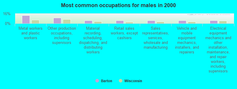
- Metal workers and plastic workers (13.0%)
- Other production occupations, including supervisors (9.0%)
- Material recording, scheduling, dispatching, and distributing workers (5.1%)
- Retail sales workers, except cashiers (5.0%)
- Sales representatives, services, wholesale and manufacturing (5.0%)
- Vehicle and mobile equipment mechanics, installers, and repairers (4.6%)
- Electrical equipment mechanics and other installation, maintenance, and repair workers, including supervisors (4.6%)
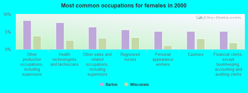
- Other production occupations, including supervisors (8.3%)
- Health technologists and technicians (7.6%)
- Other sales and related occupations, including supervisors (6.4%)
- Registered nurses (5.6%)
- Personal appearance workers (5.1%)
- Cashiers (5.1%)
- Financial clerks, except bookkeeping, accounting and auditing clerks (5.1%)
Average climate in Barton, Wisconsin
Based on data reported by over 4,000 weather stations


(lower is better)
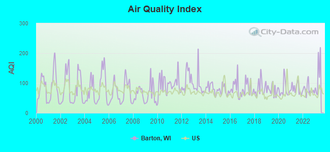
Air Quality Index (AQI) level in 2022 was 77.7. This is about average.
| City: | 77.7 |
| U.S.: | 72.6 |
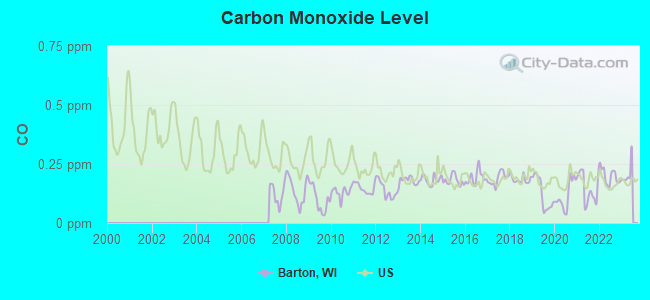
Carbon Monoxide (CO) [ppm] level in 2022 was 0.198. This is better than average. Closest monitor was 15.7 miles away from the city center.
| City: | 0.198 |
| U.S.: | 0.251 |
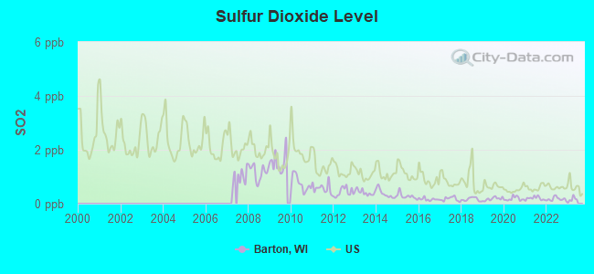
Sulfur Dioxide (SO2) [ppb] level in 2022 was 0.173. This is significantly better than average. Closest monitor was 14.8 miles away from the city center.
| City: | 0.173 |
| U.S.: | 1.515 |
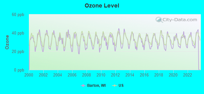
Ozone [ppb] level in 2022 was 32.0. This is about average. Closest monitor was 8.8 miles away from the city center.
| City: | 32.0 |
| U.S.: | 33.3 |
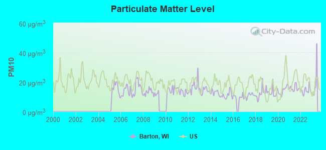
Particulate Matter (PM10) [µg/m3] level in 2022 was 14.1. This is better than average. Closest monitor was 10.8 miles away from the city center.
| City: | 14.1 |
| U.S.: | 19.2 |
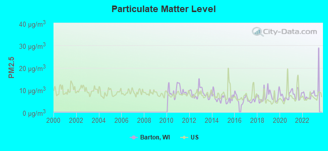
Particulate Matter (PM2.5) [µg/m3] level in 2022 was 7.30. This is about average. Closest monitor was 15.7 miles away from the city center.
| City: | 7.30 |
| U.S.: | 8.11 |
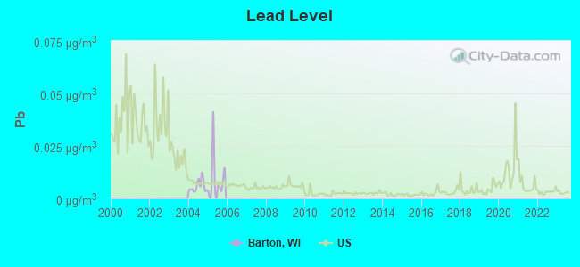
Lead (Pb) [µg/m3] level in 2005 was 0.0105. This is about average. Closest monitor was 15.7 miles away from the city center.
| City: | 0.0105 |
| U.S.: | 0.0093 |
Tornado activity:
Barton-area historical tornado activity is slightly above Wisconsin state average. It is 38% greater than the overall U.S. average.
On 7/18/1996, a category F5 (max. wind speeds 261-318 mph) tornado 20.2 miles away from the Barton town center injured 12 people and caused $40 million in damages.
On 4/4/1981, a category F4 (max. wind speeds 207-260 mph) tornado 1.8 miles away from the town center killed 3 people and injured 53 people and caused between $5,000,000 and $50,000,000 in damages.
Earthquake activity:
Barton-area historical earthquake activity is significantly above Wisconsin state average. It is 4% greater than the overall U.S. average.On 4/18/2008 at 09:36:59, a magnitude 5.4 (5.1 MB, 4.8 MS, 5.4 MW, 5.2 MW, Class: Moderate, Intensity: VI - VII) earthquake occurred 346.4 miles away from the city center
On 6/28/2004 at 06:10:52, a magnitude 4.2 (4.2 MW, Depth: 6.2 mi, Class: Light, Intensity: IV - V) earthquake occurred 142.3 miles away from Barton center
On 6/10/1987 at 23:48:54, a magnitude 5.1 (4.9 MB, 4.4 MS, 4.6 MS, 5.1 LG) earthquake occurred 320.9 miles away from Barton center
On 4/18/2008 at 09:36:59, a magnitude 5.2 (5.2 MW, Depth: 8.9 mi) earthquake occurred 346.4 miles away from the city center
On 5/2/2015 at 16:23:07, a magnitude 4.2 (4.2 MW, Depth: 2.8 mi) earthquake occurred 164.6 miles away from Barton center
On 2/10/2010 at 09:59:35, a magnitude 3.8 (3.8 MW, Depth: 6.2 mi, Class: Light, Intensity: II - III) earthquake occurred 103.7 miles away from the city center
Magnitude types: regional Lg-wave magnitude (LG), body-wave magnitude (MB), surface-wave magnitude (MS), moment magnitude (MW)
Natural disasters:
The number of natural disasters in Washington County (11) is smaller than the US average (15).Major Disasters (Presidential) Declared: 8
Emergencies Declared: 3
Causes of natural disasters: Storms: 6, Floods: 5, Drought: 1, Hurricane: 1, Snow: 1, Snowstorm: 1, Tornado: 1, Wind: 1, Winter Storm: 1, Other: 1 (Note: some incidents may be assigned to more than one category).

Hospitals and medical centers near Barton:
- SAMARITAN HEALTH CENTER (Nursing Home, about 3 miles away; WEST BEND, WI)
- CEDAR COMMUNITY HOME HEALTH AGENCY (Home Health Center, about 5 miles away; WEST BEND, WI)
- THE KATHY HOSPICE (Hospital, about 8 miles away; WEST BEND, WI)
- ST JOSEPH'S COMMUNITY HOSPITAL OF WEST BEND, INC Acute Care Hospitals (about 8 miles away; WEST BEND, WI)
- SAMARITAN'S CEDAR CROSSING SUBACUTE UNIT (Nursing Home, about 8 miles away; WESTBEND, WI)
- HARDFORD CARE CENTER (Nursing Home, about 12 miles away; HARTFORD, WI)
- HARTFORD HLTHCARE CTR (Nursing Home, about 12 miles away; HARTFORD, WI)
Colleges/universities with over 2000 students nearest to Barton:
- Concordia University-Wisconsin (about 21 miles; Mequon, WI; Full-time enrollment: 5,253)
- Marian University (about 25 miles; Fond Du Lac, WI; FT enrollment: 2,045)
- Moraine Park Technical College (about 26 miles; Fond du Lac, WI; FT enrollment: 3,079)
- Waukesha County Technical College (about 27 miles; Pewaukee, WI; FT enrollment: 4,415)
- Cardinal Stritch University (about 27 miles; Milwaukee, WI; FT enrollment: 3,595)
- University of Wisconsin-Milwaukee (about 32 miles; Milwaukee, WI; FT enrollment: 24,196)
- Carroll University (about 32 miles; Waukesha, WI; FT enrollment: 3,313)
Points of interest:
Notable location: Highview Farm (A). Display/hide its location on the map
Church in Barton: Tree of Life Ministries Church (A). Display/hide its location on the map
Cemeteries: Newark Cemetery (1), Old Saint Marys Cemetery (2). Display/hide their locations on the map
Lakes and reservoirs: Smith Lake (A), Allis Lake (B), Lake Lenwood (C), 204 Reservoir (D). Display/hide their locations on the map
| This town: | 2.5 people |
| Wisconsin: | 2.4 people |
| This town: | 77.0% |
| Whole state: | 64.4% |
| This town: | 4.5% |
| Whole state: | 7.3% |
Likely homosexual households (counted as self-reported same-sex unmarried-partner households)
- Lesbian couples: 0.1% of all households
- Gay men: 0.3% of all households
| This town: | 1.7% |
| Whole state: | 8.7% |
| This town: | 1.4% |
| Whole state: | 3.7% |
For population 15 years and over in Barton:
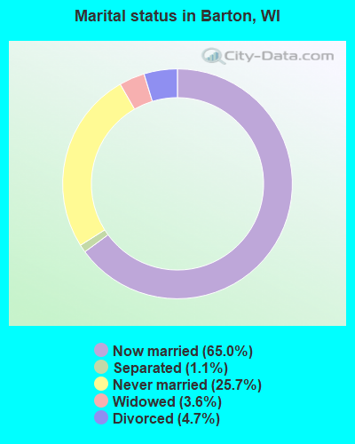
- Never married: 25.7%
- Now married: 65.0%
- Separated: 1.1%
- Widowed: 3.6%
- Divorced: 4.7%
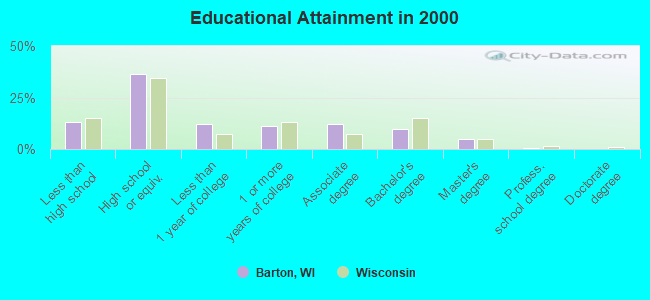
For population 25 years and over in Barton:
- High school or higher: 87.1%
- Bachelor's degree or higher: 15.1%
- Graduate or professional degree: 5.5%
- Unemployed: 3.4%
- Mean travel time to work (commute): 25.1 minutes
| Here: | 9.2 |
| Wisconsin average: | 11.0 |
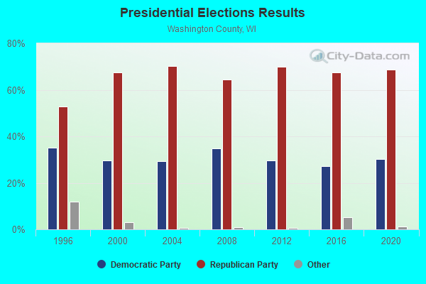
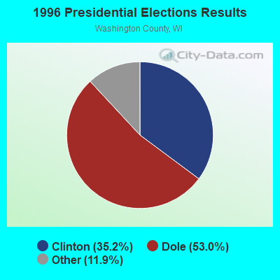

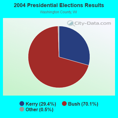
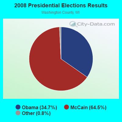

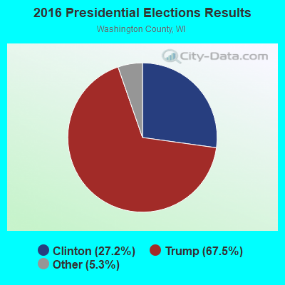

Graphs represent county-level data. Detailed 2008 Election Results
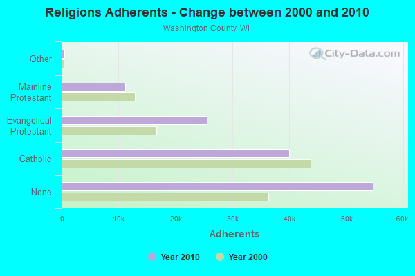
Religion statistics for Barton, WI (based on Washington County data)
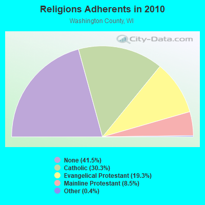
| Religion | Adherents | Congregations |
|---|---|---|
| Catholic | 39,943 | 13 |
| Evangelical Protestant | 25,503 | 49 |
| Mainline Protestant | 11,157 | 30 |
| Other | 532 | 7 |
| Orthodox | 28 | 1 |
| None | 54,724 | - |
Food Environment Statistics:
| Here: | 1.25 / 10,000 pop. |
| Wisconsin: | 1.86 / 10,000 pop. |
| Here: | 0.08 / 10,000 pop. |
| Wisconsin: | 0.11 / 10,000 pop. |
| This county: | 0.16 / 10,000 pop. |
| Wisconsin: | 0.38 / 10,000 pop. |
| Washington County: | 3.83 / 10,000 pop. |
| State: | 4.12 / 10,000 pop. |
| This county: | 7.11 / 10,000 pop. |
| Wisconsin: | 8.64 / 10,000 pop. |
| Washington County: | 6.4% |
| State: | 7.6% |
| Washington County: | 26.5% |
| Wisconsin: | 27.5% |
| Washington County: | 10.7% |
| State: | 13.0% |
Strongest AM radio stations in Barton:
- WBKV (1470 AM; 2 kW; WEST BEND, WI; Owner: WEST BEND BROADCASTING CO.)
- WTMJ (620 AM; 50 kW; MILWAUKEE, WI; Owner: JOURNAL BROADCAST CORPORATION)
- WISN (1130 AM; 50 kW; MILWAUKEE, WI; Owner: CAPSTAR TX LIMITED PARTNERSHIP)
- WNAM (1280 AM; 50 kW; NEENAH-MENASHA, WI; Owner: CUMULUS LICENSING CORP.)
- WKSH (1640 AM; 10 kW; SUSSEX, WI; Owner: ABC, INC.)
- WHBY (1150 AM; 25 kW; KIMBERLY, WI; Owner: WOODWARD COMMUNICATIONS, INC.)
- WRRD (540 AM; 0 kW; JACKSON, WI; Owner: SCA LICENSE CORPORATION)
- WAUK (1510 AM; daytime; 10 kW; WAUKESHA, WI; Owner: WALT-WEST WISCONSIN, INC.)
- WGN (720 AM; 50 kW; CHICAGO, IL; Owner: WGN CONTINENTAL BROADCASTING CO.)
- WSCR (670 AM; 50 kW; CHICAGO, IL; Owner: INFINITY BROADCASTING OPERATIONS, INC.)
- WBBM (780 AM; 50 kW; CHICAGO, IL; Owner: INFINITY BROADCASTING OPERATIONS, INC.)
- WSPT (1010 AM; 50 kW; STEVENS POINT, WI)
- WOKY (920 AM; 5 kW; MILWAUKEE, WI; Owner: CLEAR CHANNEL BROADCASTING LICENSES, INC.)
Strongest FM radio stations in Barton:
- WBWI-FM (92.5 FM; WEST BEND, WI; Owner: WEST BEND BROADCASTING CO.)
- WLTQ (97.3 FM; MILWAUKEE, WI; Owner: CAPSTAR TX LIMITED PARTNERSHIP)
- WMIL-FM (106.1 FM; WAUKESHA, WI; Owner: CLEAR CHANNEL BROADCASTING LICENSES, INC.)
- WJZI (93.3 FM; MILWAUKEE, WI; Owner: MILWAUKEE RADIO ALLIANCE, LLC)
- WKTI-FM (94.5 FM; MILWAUKEE, WI; Owner: JOURNAL BROADCAST CORPORATION)
- WUWM (89.7 FM; MILWAUKEE, WI; Owner: BOARD OF REGENTS, UNIVERSITY OF WISCONSIN SYSTEM)
- WXSS (103.7 FM; WAUWATOSA, WI; Owner: ENTERCOM MILWAUKEE LICENSE, LLC)
- WKLH (96.5 FM; MILWAUKEE, WI; Owner: LAKEFRONT COMMUNICATIONS, LLC)
- WGLB-FM (100.1 FM; PORT WASHINGTON, WI; Owner: STARBOARD MEDIA FOUNDATION, INC.)
- WSTM (91.3 FM; KIEL, WI; Owner: JUBILATION MINISTRIES INC)
- WLUM-FM (102.1 FM; MILWAUKEE, WI; Owner: MILWAUKEE RADIO ALLIANCE, LLC)
- WMWK (88.1 FM; MILWAUKEE, WI; Owner: FAMILY STATIONS, INC.)
- WMDC (98.7 FM; MAYVILLE, WI; Owner: RADIO PLUS, INC.)
- WTKM-FM (104.9 FM; HARTFORD, WI; Owner: KETTLE MORAINE B/CTING COMPANY, INC.)
- WFDL-FM (97.7 FM; LOMIRA, WI; Owner: RADIO PLUS OF FOND DU LAC, INC.)
- WHAD (90.7 FM; DELAFIELD, WI; Owner: STATE OF WISCONSIN - EDUCATIONAL COMMUNICATIONS BOARD)
- WRIT-FM (95.7 FM; MILWAUKEE, WI; Owner: CLEAR CHANNEL BROADCASTING LICENSES, INC.)
- WXER (104.5 FM; PLYMOUTH, WI; Owner: RBH ENTERPRISES, INC. D/B/A YELLOW DOG BROADCASTING)
- WFZH (105.3 FM; MUKWONAGO, WI; Owner: CARON BROADCASTING, INC.)
- WFMR (106.9 FM; BROOKFIELD, WI; Owner: SAGA COMMUNICATIONS OF MILWAUKEE, LLC)
TV broadcast stations around Barton:
- WWRS-TV (Channel 52; MAYVILLE, WI; Owner: NATIONAL MINORITY T.V., INC.)
- WMMF-TV (Channel 68; FOND DU LAC, WI; Owner: PAPPAS TELECASTING OF WISCONSIN, A CALIFORNIA LTD PARTNRSHP)
- WITI (Channel 6; MILWAUKEE, WI; Owner: WITI LICENSE,INC.)
- WDJT-TV (Channel 58; MILWAUKEE, WI; Owner: WDJT-TV LIMITED PARTNERSHIP)
- WISN-TV (Channel 12; MILWAUKEE, WI; Owner: WISN HEARST-ARGYLE TV, INC. (CA CORP.))
- WPXE (Channel 55; KENOSHA, WI; Owner: PAXSON MILWAUKEE LICENSE, INC.)
- WMVS (Channel 10; MILWAUKEE, WI; Owner: MILWAUKEE AREA TECHNICAL COLLEGE DISTRICT BOARD)
- WMVT (Channel 36; MILWAUKEE, WI; Owner: MILWAUKEE AREA TECHNICAL COLLEGE DISTRICT BOARD)
- WMLW-CA (Channel 46; MILWAUKEE, WI; Owner: CHANNEL 41 AND 63 LIMITED PARTNERSHIP)
- W63CU (Channel 63; MILWAUKEE, WI; Owner: CHANNEL 41 AND 63 LIMITED PARTNERSHIP)
- WCGV-TV (Channel 24; MILWAUKEE, WI; Owner: WCGV LICENSEE, LLC)
- WVTV (Channel 18; MILWAUKEE, WI; Owner: WVTV LICENSEE, INC.)
- WTMJ-TV (Channel 4; MILWAUKEE, WI; Owner: JOURNAL BROADCAST CORPORATION)
- WVCY-TV (Channel 30; MILWAUKEE, WI; Owner: VCY AMERICA, INC.)
- WMKE-CA (Channel 7; MILWAUKEE, WI; Owner: KM LPTV OF MILWAUKEE, L.L.C.)
- National Bridge Inventory (NBI) Statistics
- 11Number of bridges
- 98ft / 30.5mTotal length
- $421,000Total costs
- 59,187Total average daily traffic
- 2,390Total average daily truck traffic
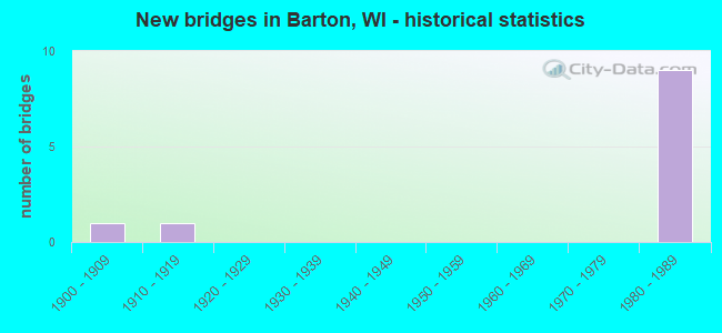
- New bridges - historical statistics
- 11900-1909
- 11910-1919
- 91980-1989
FCC Registered Antenna Towers:
11 (See the full list of FCC Registered Antenna Towers in Barton)FCC Registered Microwave Towers:
2- Barton, 7579 Friendly Dr. (Lat: 43.464722 Lon: -88.207778), Type: Tower, Structure height: 88.3 m, Overall height: 89.9 m, Call Sign: WPWK394,
Assigned Frequencies: 6315.84 MHz, Grant Date: 12/05/2002, Expiration Date: 12/05/2012, Cancellation Date: 09/28/2012, Certifier: Kenneth R Meyers, Registrant: Holland & Knight LLP, 800 17th Street, N.W., Suite #1100, Washington, DC 20006-3906, Phone: (202) 955-3000, Fax: (202) 955-5564, Email:
- Barton Wt Tower, Lat: 43.437556 Lon: -88.185444, Type: Tank, Structure height: 45.7 m, Overall height: 46 m, Call Sign: WQJH835,
Assigned Frequencies: 3650.00 MHz, Grant Date: 09/16/2008, Expiration Date: 09/16/2018, Cancellation Date: 11/17/2018, Certifier: Mark E Dodge, Registrant: Granite Wireless, Inc., 300 Industrial Dr, Random Lake, WI 53075, Phone: (920) 994-2388, Email:
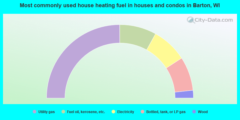
- 49.9%Utility gas
- 16.2%Fuel oil, kerosene, etc.
- 15.6%Electricity
- 14.9%Bottled, tank, or LP gas
- 3.4%Wood
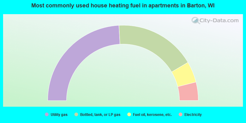
- 48.3%Utility gas
- 34.8%Bottled, tank, or LP gas
- 9.0%Fuel oil, kerosene, etc.
- 7.9%Electricity
Barton compared to Wisconsin state average:
- Unemployed percentage significantly below state average.
- Black race population percentage significantly below state average.
- Hispanic race population percentage significantly below state average.
- Median age above state average.
- Foreign-born population percentage significantly below state average.
- Renting percentage significantly below state average.
- Length of stay since moving in significantly above state average.
- Number of rooms per house significantly below state average.
- House age significantly below state average.
- Percentage of population with a bachelor's degree or higher below state average.