Bridge Statistics for Wilmington, North Carolina (NC)
Condition, Traffic, Stress, Structural Evaluation, Project Costs
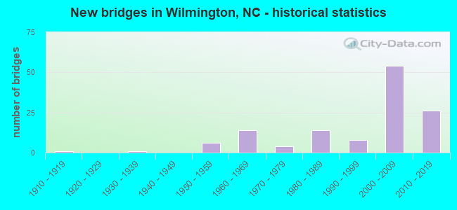
- New bridges - historical statistics
- 11910-1919
- 11930-1939
- 61950-1959
- 141960-1969
- 41970-1979
- 141980-1989
- 81990-1999
- 542000-2009
- 262010-2019
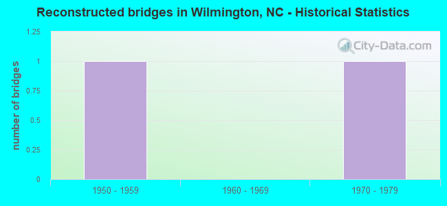
- Reconstructed bridges - Historical Statistics
- 11950-1959
- 01960-1969
- 11970-1979
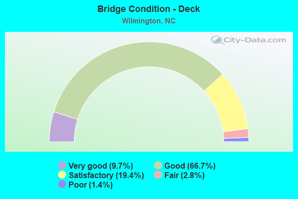
- Bridge Condition - Deck
- 9.7%Very good
- 66.7%Good
- 19.4%Satisfactory
- 2.8%Fair
- 1.4%Poor
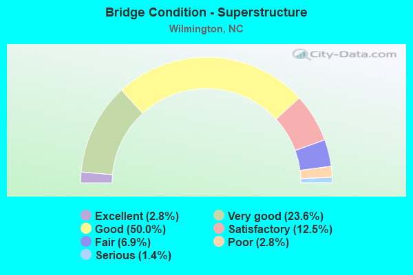
- Bridge Condition - Superstructure
- 2.8%Excellent
- 23.6%Very good
- 50.0%Good
- 12.5%Satisfactory
- 6.9%Fair
- 2.8%Poor
- 1.4%Serious
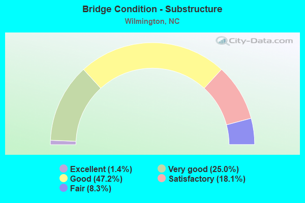
- Bridge Condition - Substructure
- 1.4%Excellent
- 25.0%Very good
- 47.2%Good
- 18.1%Satisfactory
- 8.3%Fair
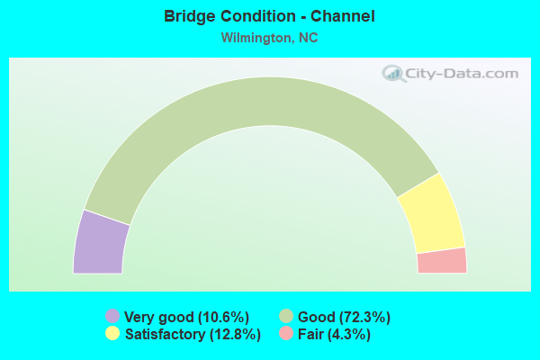
- Bridge Condition - Channel
- 10.6%Very good
- 72.3%Good
- 12.8%Satisfactory
- 4.3%Fair
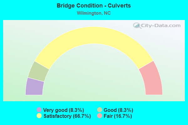
- Bridge Condition - Culverts
- 8.3%Very good
- 8.3%Good
- 66.7%Satisfactory
- 16.7%Fair
Find on map >> Show street view
Structure Number: 1290197, Location: 0.2 MI. S. JCT. US421 (Lat: 34.286669, Lng: -78.970544), Route carried "on" structure: Ramp Interstate 140, Year Built: 2017, Status: Open, Structure Length: 2.80m (9.19ft), Average Daily Traffic: 13,500 (year 2018), Truck Traffic: 16%, Average Future Daily Traffic: 27,000 (year 2040), Design Load: HL 93, Features Intersected: CSX & SCRR
Minimum Vertical Clearance: 30+ m (98+ ft), Kilometerpoint: 0.000, Lanes on structure: 1, Owner: State Highway Agency, Approaching Roadway Width: 7.3m (24.0ft), Skew: 2 degrees, Material/Design: Prestressed concrete, Design/Construction: Stringer/Multi-beam, Number Of Spans In Main Unit: 1, Length of Maximum Span: 26.8m (87.9ft), Curb-To-Curb Width: 7.7m (25.3ft), Out-to-Out Width: 8.9m (29.2ft)
Condition: Deck: Good, Superstructure: Excellent, Substructure: Good, Operating Rating: 62.5 metric tons, Method Used To Determine Operating Rating: Load and Resistance Factor (LRFR), Inventory Rating: 43.5 metric tons, Method Used To Determine Inventory Rating: Load and Resistance Factor (LRFR), Structural Evaluation: Better than present minimum criteria, Deck Geometry: Better than present minimum criteria, Underclear: Superior to present desirable criteria, Approach Roadway Alignment: Equal to present desirable criteria, Designated Inspection Frequency: Every 24 months, Inspection Date: April 2020, Deck Structure Type: Concrete Cast-file-Place, Wearing Surface/Protective System: Wearing Surface: Monolithic Concrete
Find on map >> Show street view
Structure Number: 1290206, Location: 1.25 MI.S.JCT.SR1209 (Lat: 34.149181, Lng: -77.934119), Route carried "on" structure: City street , Year Built: 2015, Status: Open, Structure Length: 2.83m (9.28ft), Average Daily Traffic: 2,500 (year 2017), Truck Traffic: 7%, Average Future Daily Traffic: 5,000 (year 2040), Design Load: HL 93, Features Intersected: NORTH LAKE, Facility Carried by Structure: RIVER ROAD
Minimum Vertical Clearance: 30+ m (98+ ft), Kilometerpoint: 0.000, Lanes on structure: 2, Owner: City or Municipal Highway Agency, Approaching Roadway Width: 5.7m (18.7ft), Material/Design: Prestressed concrete, Design/Construction: Box Beam or Girders - Multiple, Number Of Spans In Main Unit: 1, Length of Maximum Span: 27.1m (88.9ft), Curb or Sidewalk Widths: Left: 0.0m, Right: 3.2m (10.5ft), Curb-To-Curb Width: 9.1m (29.9ft), Out-to-Out Width: 13.7m (44.9ft)
Condition: Deck: Good, Superstructure: Very good, Substructure: Very good, Channel: Very good, Operating Rating: 72.5 metric tons, Method Used To Determine Operating Rating: Load and Resistance Factor (LRFR), Inventory Rating: 55.3 metric tons, Method Used To Determine Inventory Rating: Load and Resistance Factor (LRFR), Structural Evaluation: Equal to present desirable criteria, Deck Geometry: Meets minimum limits, Waterway Adequacy: Equal to present desirable criteria, Approach Roadway Alignment: Equal to present desirable criteria, Designated Inspection Frequency: Every 24 months, Inspection Date: April 2020, Deck Structure Type: Concrete Precast Panels, Wearing Surface/Protective System: Wearing Surface: Monolithic Concrete
Find on map >> Show street view
Structure Number: 1290207, Location: 1.25 MI.S.JCT.SR1209 (Lat: 34.149317, Lng: -77.934033), Route carried "on" structure: City street , Year Built: 2015, Status: Open, Structure Length: 2.83m (9.28ft), Average Daily Traffic: 7,700 (year 2017), Truck Traffic: 7%, Average Future Daily Traffic: 14,500 (year 2040), Design Load: HL 93, Features Intersected: NORTH LAKE, Facility Carried by Structure: RIVER ROAD
Minimum Vertical Clearance: 30+ m (98+ ft), Kilometerpoint: 0.000, Lanes on structure: 2, Owner: City or Municipal Highway Agency, Approaching Roadway Width: 5.7m (18.7ft), Material/Design: Prestressed concrete, Design/Construction: Box Beam or Girders - Multiple, Number Of Spans In Main Unit: 1, Length of Maximum Span: 27.1m (88.9ft), Curb-To-Curb Width: 8.9m (29.2ft), Out-to-Out Width: 10.0m (32.8ft)
Condition: Deck: Good, Superstructure: Good, Substructure: Very good, Channel: Very good, Operating Rating: 74.3 metric tons, Method Used To Determine Operating Rating: Load and Resistance Factor (LRFR), Inventory Rating: 57.1 metric tons, Method Used To Determine Inventory Rating: Load and Resistance Factor (LRFR), Structural Evaluation: Better than present minimum criteria, Deck Geometry: High priority of replacement, Waterway Adequacy: Equal to present desirable criteria, Approach Roadway Alignment: Equal to present desirable criteria, Designated Inspection Frequency: Every 24 months, Inspection Date: April 2020, Deck Structure Type: Concrete Precast Panels, Wearing Surface/Protective System: Wearing Surface: Monolithic Concrete, Deck Protection: Epoxy Coated Reinforcing
Find on map >> Show street view
Structure Number: 190007, Location: 1.9 MI. N. OF JCT. NC 133 (Lat: 34.231083, Lng: -77.960353), Route carried "under" structure: US 76, Year Built: 1968, Structure Length: 0. m, Average Daily Traffic: 30,500 (year 2017), Truck Traffic: 12%, Features Intersected: US17
Minimum Vertical Clearance: 4.87m (15.98ft), Kilometerpoint: 0.000, Lanes on structure: 3, Lanes under structure: 3, Material/Design: Steel, Design/Construction: Stringer/Multi-beam, Length of Maximum Span: 21.3m (69.9ft)
Find on map >> Show street view
Structure Number: 190007, Location: 1.9 MI. N. OF JCT. NC 133 (Lat: 34.231083, Lng: -77.960353), Route carried "under" structure: US 76, Year Built: 1968, Structure Length: 0. m, Average Daily Traffic: 30,500 (year 2017), Truck Traffic: 12%, Features Intersected: US17
Minimum Vertical Clearance: 4.90m (16.08ft), Kilometerpoint: 0.000, Lanes on structure: 3, Lanes under structure: 2, Material/Design: Steel, Design/Construction: Stringer/Multi-beam, Length of Maximum Span: 21.3m (69.9ft)
Find on map >> Show street view
Structure Number: 190232, Location: 4.9 MI.W.JCT.US74/US76 (Lat: 34.190439, Lng: -78.078906), Route carried "under" structure: US 17, Year Built: 2015, Structure Length: 0. m, Average Daily Traffic: 14,000 (year 2015), Truck Traffic: 12%, Features Intersected: I140
Minimum Vertical Clearance: 5.81m (19.06ft), Kilometerpoint: 0.000, Lanes on structure: 3, Lanes under structure: 3, Material/Design: Prestressed concrete continuous, Design/Construction: Stringer/Multi-beam, Length of Maximum Span: 28.0m (91.9ft)
Find on map >> Show street view
Structure Number: 190232, Location: 4.9 MI.W.JCT.US74/US76 (Lat: 34.190439, Lng: -78.078906), Route carried "under" structure: US 17, Year Built: 2015, Structure Length: 0. m, Average Daily Traffic: 14,000 (year 2015), Truck Traffic: 12%, Features Intersected: I140
Minimum Vertical Clearance: 5.56m (18.24ft), Kilometerpoint: 0.000, Lanes on structure: 3, Lanes under structure: 2, Material/Design: Prestressed concrete continuous, Design/Construction: Stringer/Multi-beam, Length of Maximum Span: 28.0m (91.9ft)
Find on map >> Show street view
Structure Number: 190247, Location: 4.9 MI E JCT US17 (Lat: 34.258058, Lng: -78.079825), Route carried "under" structure: US 74, Year Built: 2015, Structure Length: 0. m, Average Daily Traffic: 13,000 (year 2015), Truck Traffic: 12%, Features Intersected: I140E
Minimum Vertical Clearance: 6.24m (20.47ft), Kilometerpoint: 0.000, Lanes on structure: 2, Lanes under structure: 2, Material/Design: Prestressed concrete, Design/Construction: Stringer/Multi-beam, Length of Maximum Span: 36.8m (120.7ft)
Find on map >> Show street view
Structure Number: 190247, Location: 4.9 MI E JCT US17 (Lat: 34.258058, Lng: -78.079825), Route carried "under" structure: US 74, Year Built: 2015, Structure Length: 0. m, Average Daily Traffic: 13,000 (year 2015), Truck Traffic: 12%, Features Intersected: I140E
Minimum Vertical Clearance: 5.54m (18.18ft), Kilometerpoint: 0.000, Lanes on structure: 2, Lanes under structure: 2, Material/Design: Prestressed concrete, Design/Construction: Stringer/Multi-beam, Length of Maximum Span: 36.8m (120.7ft)
Find on map >> Show street view
Structure Number: 190248, Location: 4.9 MI. E. JCT. US17 (Lat: 34.258094, Lng: -78.080094), Route carried "under" structure: US 74, Year Built: 2015, Structure Length: 0. m, Average Daily Traffic: 15,000 (year 2018), Truck Traffic: 12%, Features Intersected: I140W
Minimum Vertical Clearance: 5.73m (18.80ft), Kilometerpoint: 0.000, Lanes on structure: 3, Lanes under structure: 2, Material/Design: Prestressed concrete, Design/Construction: Stringer/Multi-beam, Length of Maximum Span: 36.8m (120.7ft)
Find on map >> Show street view
Structure Number: 190248, Location: 4.9 MI. E. JCT. US17 (Lat: 34.258094, Lng: -78.080094), Route carried "under" structure: US 740, Year Built: 2015, Structure Length: 0. m, Average Daily Traffic: 15,000 (year 2018), Truck Traffic: 12%, Features Intersected: I140W, Facility Carried by Structure: US74S,US76S
Minimum Vertical Clearance: 6.49m (21.29ft), Kilometerpoint: 0.000, Lanes on structure: 3, Lanes under structure: 2, Material/Design: Prestressed concrete, Design/Construction: Stringer/Multi-beam, Length of Maximum Span: 36.8m (120.7ft)
Find on map >> Show street view
Structure Number: 1290003, Location: 0.6 MI. S. JCT. US74 (Lat: 34.245983, Lng: -77.870983), Route carried "under" structure: Business US 17, Year Built: 1980, Structure Length: 0. m, Average Daily Traffic: 20,000 (year 2018), Truck Traffic: 12%, Features Intersected: US117,NC132N
Minimum Vertical Clearance: 6.88m (22.57ft), Kilometerpoint: 0.000, Lanes on structure: 2, Lanes under structure: 3, Material/Design: Steel, Design/Construction: Stringer/Multi-beam, Length of Maximum Span: 18.2m (59.7ft)
Find on map >> Show street view
Structure Number: 1290003, Location: 0.6 MI. S. JCT. US74 (Lat: 34.245983, Lng: -77.870983), Route carried "under" structure: Business US 17, Year Built: 1980, Structure Length: 0. m, Average Daily Traffic: 20,000 (year 2018), Truck Traffic: 12%, Features Intersected: US117,NC132N
Minimum Vertical Clearance: 6.78m (22.24ft), Kilometerpoint: 0.000, Lanes on structure: 2, Lanes under structure: 3, Material/Design: Steel, Design/Construction: Stringer/Multi-beam, Length of Maximum Span: 18.2m (59.7ft)
Find on map >> Show street view
Structure Number: 1290008, Location: 0.6 MI. S. JCT. US74 (Lat: 34.245950, Lng: -77.871169), Route carried "under" structure: Business US 17, Year Built: 1958, Structure Length: 0. m, Average Daily Traffic: 38,000 (year 2018), Truck Traffic: 12%, Features Intersected: US117,NC132S
Minimum Vertical Clearance: 6.78m (22.24ft), Kilometerpoint: 0.000, Lanes on structure: 2, Lanes under structure: 3, Material/Design: Steel, Design/Construction: Stringer/Multi-beam, Length of Maximum Span: 16.4m (53.8ft)
Find on map >> Show street view
Structure Number: 1290008, Location: 0.6 MI. S. JCT. US74 (Lat: 34.245950, Lng: -77.871169), Route carried "under" structure: Business US 17, Year Built: 1958, Structure Length: 0. m, Average Daily Traffic: 38,000 (year 2018), Truck Traffic: 12%, Features Intersected: US117,NC132S
Minimum Vertical Clearance: 6.80m (22.31ft), Kilometerpoint: 0.000, Lanes on structure: 2, Lanes under structure: 3, Material/Design: Steel, Design/Construction: Stringer/Multi-beam, Length of Maximum Span: 16.4m (53.8ft)
Find on map >> Show street view
Structure Number: 1290011, Location: 0.1MI N JCT US421 (Lat: 34.251722, Lng: -77.950203), Route carried "under" structure: Ramp State highway 2649, Year Built: 1980, Structure Length: 0. m, Average Daily Traffic: 6,750 (year 2017), Truck Traffic: 7%, Features Intersected: US74
Minimum Vertical Clearance: 7.64m (25.07ft), Kilometerpoint: 0.000, Lanes on structure: 4, Lanes under structure: 1, Material/Design: Steel, Design/Construction: Movable - Bascule, Length of Maximum Span: 96.3m (315.9ft)
Find on map >> Show street view
Structure Number: 1290013, Location: 0.35 MI.E. JCT. US133 (Lat: 34.227428, Lng: -77.951894), Route carried "under" structure: City street , Year Built: 1969, Structure Length: 0. m, Average Daily Traffic: 100 (year 2015), Truck Traffic: 7%, Features Intersected: US17,US76,US421, Facility Carried by Structure: QUEENST.E
Minimum Vertical Clearance: 7.33m (24.05ft), Kilometerpoint: 0.000, Lanes on structure: 4, Lanes under structure: 2, Material/Design: Steel, Design/Construction: Movable - Lift, Length of Maximum Span: 125.8m (412.7ft)
Find on map >> Show street view
Structure Number: 1290013, Location: 0.35 MI.E. JCT. US133 (Lat: 34.227428, Lng: -77.951894), Route carried "under" structure: City street , Year Built: 1969, Structure Length: 0. m, Average Daily Traffic: 300 (year 2018), Truck Traffic: 7%, Features Intersected: US17,US76,US421, Facility Carried by Structure: QUEENST.E
Minimum Vertical Clearance: 7.97m (26.15ft), Kilometerpoint: 0.000, Lanes on structure: 4, Lanes under structure: 2, Material/Design: Steel, Design/Construction: Movable - Lift, Length of Maximum Span: 125.8m (412.7ft)
Find on map >> Show street view
Structure Number: 1290013, Location: 0.35 MI.E. JCT. US133 (Lat: 34.227428, Lng: -77.951894), Route carried "under" structure: City street , Year Built: 1969, Structure Length: 0. m, Average Daily Traffic: 12,500 (year 2019), Truck Traffic: 8%, Features Intersected: US17,US76,US421, Facility Carried by Structure: S.FRONTST.
Minimum Vertical Clearance: 5.31m (17.42ft), Kilometerpoint: 0.000, Lanes on structure: 4, Lanes under structure: 1, Material/Design: Steel, Design/Construction: Movable - Lift, Length of Maximum Span: 125.8m (412.7ft)
Find on map >> Show street view
Structure Number: 1290013, Location: 0.35 MI.E. JCT. US133 (Lat: 34.227428, Lng: -77.951894), Route carried "under" structure: City street , Year Built: 1969, Structure Length: 0. m, Average Daily Traffic: 100 (year 2010), Truck Traffic: 7%, Features Intersected: US17,US76,US421, Facility Carried by Structure: SURRYST.
Minimum Vertical Clearance: 10.31m (33.83ft), Kilometerpoint: 0.000, Lanes on structure: 4, Lanes under structure: 2, Material/Design: Steel, Design/Construction: Movable - Lift, Length of Maximum Span: 125.8m (412.7ft)
Find on map >> Show street view
Structure Number: 1290013, Location: 0.35 MI.E. JCT. US133 (Lat: 34.227428, Lng: -77.951894), Route carried "under" structure: City street , Year Built: 1969, Structure Length: 0. m, Average Daily Traffic: 12,500 (year 2019), Truck Traffic: 8%, Features Intersected: US17,US76,US421, Facility Carried by Structure: N.FRONTST. N
Minimum Vertical Clearance: 5.31m (17.42ft), Kilometerpoint: 0.000, Lanes on structure: 4, Lanes under structure: 3, Material/Design: Steel, Design/Construction: Movable - Lift, Length of Maximum Span: 125.8m (412.7ft)
Find on map >> Show street view
Structure Number: 1290013, Location: 0.35 MI.E. JCT. US133 (Lat: 34.227428, Lng: -77.951894), Route carried "under" structure: State highway 1300, Year Built: 1969, Structure Length: 0. m, Average Daily Traffic: 300 (year 2018), Truck Traffic: 7%, Features Intersected: US17,US76,US421
Minimum Vertical Clearance: 11.98m (39.30ft), Kilometerpoint: 0.000, Lanes on structure: 4, Lanes under structure: 2, Material/Design: Steel, Design/Construction: Movable - Lift, Length of Maximum Span: 125.8m (412.7ft)
Find on map >> Show street view
Structure Number: 1290058, Location: JCT. OF I40 & SR2048 (Lat: 34.277697, Lng: -77.868236), Route carried "under" structure: State highway 2048, Year Built: 1985, Structure Length: 0. m, Average Daily Traffic: 11,250 (year 2019), Truck Traffic: 6%, Features Intersected: I40 EBL
Minimum Vertical Clearance: 5.13m (16.83ft), Kilometerpoint: 0.000, Lanes on structure: 3, Lanes under structure: 2, Material/Design: Steel, Design/Construction: Stringer/Multi-beam, Length of Maximum Span: 31.6m (103.7ft)
Find on map >> Show street view
Structure Number: 1290058, Location: JCT. OF I40 & SR2048 (Lat: 34.277697, Lng: -77.868236), Route carried "under" structure: State highway 2048, Year Built: 1985, Structure Length: 0. m, Average Daily Traffic: 11,250 (year 2019), Truck Traffic: 6%, Features Intersected: I40 EBL, Facility Carried by Structure: SR2058S
Minimum Vertical Clearance: 5.13m (16.83ft), Kilometerpoint: 0.000, Lanes on structure: 3, Lanes under structure: 3, Material/Design: Steel, Design/Construction: Stringer/Multi-beam, Length of Maximum Span: 31.6m (103.7ft)
Find on map >> Show street view
Structure Number: 1290098, Location: 5MI. S. JCT US17 (Lat: 34.319094, Lng: -77.869389), Route carried "under" structure: Ramp Interstate 40, Year Built: 2004, Structure Length: 0. m, Average Daily Traffic: 8,833 (year 2018), Truck Traffic: 16%, Features Intersected: I140S,US17SBYP CON
Minimum Vertical Clearance: 5.99m (19.65ft), Kilometerpoint: 126.798, Lanes on structure: 1, Lanes under structure: 1, Material/Design: Steel, Design/Construction: Stringer/Multi-beam, Length of Maximum Span: 38.1m (125.0ft)
Find on map >> Show street view
Structure Number: 1290099, Location: 5MI. S. JCT US17 (Lat: 34.318914, Lng: -77.869389), Route carried "under" structure: Ramp Interstate 40, Year Built: 2004, Structure Length: 0. m, Average Daily Traffic: 8,000 (year 2018), Truck Traffic: 16%, Features Intersected: US17 BYP S
Minimum Vertical Clearance: 5.81m (19.06ft), Kilometerpoint: 126.798, Lanes on structure: 2, Lanes under structure: 1, Material/Design: Steel, Design/Construction: Stringer/Multi-beam, Length of Maximum Span: 37.4m (122.7ft)
Find on map >> Show street view
Structure Number: 1290101, Location: @ JCT.I40 (Lat: 34.316758, Lng: -77.871650), Route carried "under" structure: Ramp Interstate 40, Year Built: 2005, Structure Length: 0. m, Average Daily Traffic: 15,500 (year 2015), Truck Traffic: 16%, Features Intersected: I40 RAMP W
Minimum Vertical Clearance: 5.18m (16.99ft), Kilometerpoint: 126.798, Lanes on structure: 1, Lanes under structure: 1, Material/Design: Steel continuous, Design/Construction: Stringer/Multi-beam, Length of Maximum Span: 30.1m (98.8ft)
Find on map >> Show street view
Structure Number: 1290101, Location: @ JCT.I40 (Lat: 34.316758, Lng: -77.871650), Route carried "under" structure: Interstate 40, Year Built: 2005, Structure Length: 0. m, Average Daily Traffic: 15,500 (year 2015), Truck Traffic: 16%, Features Intersected: I40 RAMP W
Minimum Vertical Clearance: 5.38m (17.65ft), Kilometerpoint: 126.798, Lanes on structure: 1, Lanes under structure: 2, Material/Design: Steel continuous, Design/Construction: Stringer/Multi-beam, Length of Maximum Span: 30.1m (98.8ft)
Find on map >> Show street view
Structure Number: 1290101, Location: @ JCT.I40 (Lat: 34.316758, Lng: -77.871650), Route carried "under" structure: Ramp Interstate 40, Year Built: 2005, Structure Length: 0. m, Average Daily Traffic: 15,500 (year 2015), Truck Traffic: 16%, Features Intersected: I40 RAMP W
Minimum Vertical Clearance: 5.48m (17.98ft), Kilometerpoint: 126.798, Lanes on structure: 1, Lanes under structure: 2, Material/Design: Steel continuous, Design/Construction: Stringer/Multi-beam, Length of Maximum Span: 30.1m (98.8ft)
Find on map >> Show street view
Structure Number: 1290103, Location: 2.5 MI. S. OF JCT. NC133 (Lat: 34.289325, Lng: -77.968392), Route carried "under" structure: US 421, Year Built: 2007, Structure Length: 0. m, Average Daily Traffic: 12,000 (year 2017), Truck Traffic: 12%, Features Intersected: I140, US17 BYP
Minimum Vertical Clearance: 5.36m (17.59ft), Kilometerpoint: 15.727, Lanes on structure: 4, Lanes under structure: 4, Material/Design: Prestressed concrete continuous, Design/Construction: Segmental Box Girder, Length of Maximum Span: 146.0m (479.0ft)
Find on map >> Show street view
Structure Number: 1290103, Location: 2.5 MI. S. OF JCT. NC133 (Lat: 34.289325, Lng: -77.968392), Route carried "under" structure: US 421, Year Built: 2007, Structure Length: 0. m, Average Daily Traffic: 12,000 (year 2017), Truck Traffic: 12%, Features Intersected: I140, US17 BYP
Minimum Vertical Clearance: 5.43m (17.81ft), Kilometerpoint: 15.727, Lanes on structure: 4, Lanes under structure: 4, Material/Design: Prestressed concrete continuous, Design/Construction: Segmental Box Girder, Length of Maximum Span: 146.0m (479.0ft)
Find on map >> Show street view
Structure Number: 1290104, Location: 1.7MI. S. JCT.NC133 (Lat: 34.309314, Lng: -77.950161), Route carried "under" structure: State highway 1331, Year Built: 2007, Structure Length: 0. m, Average Daily Traffic: 100 (year 2013), Truck Traffic: 7%, Features Intersected: I140E,US17BYP NB
Minimum Vertical Clearance: 5.38m (17.65ft), Kilometerpoint: 0.000, Lanes on structure: 2, Lanes under structure: 2, Material/Design: Prestressed concrete continuous, Design/Construction: Stringer/Multi-beam, Length of Maximum Span: 13.1m (43.0ft)
Find on map >> Show street view
Structure Number: 1290105, Location: 1.7 MI.S.JCT.US117/NC133 (Lat: 34.309347, Lng: -77.950400), Route carried "under" structure: State highway 1331, Year Built: 2007, Structure Length: 0. m, Average Daily Traffic: 200 (year 2009), Truck Traffic: 7%, Features Intersected: I140 W /US17S,BYP
Minimum Vertical Clearance: 4.57m (14.99ft), Kilometerpoint: 0.000, Lanes on structure: 2, Lanes under structure: 2, Material/Design: Prestressed concrete continuous, Design/Construction: Stringer/Multi-beam, Length of Maximum Span: 12.8m (42.0ft)
Find on map >> Show street view
Structure Number: 1290108, Location: JCT.US74 & RMP BD (Lat: 34.251136, Lng: -77.947239), Route carried "under" structure: Ramp US 74, Year Built: 2003, Structure Length: 0. m, Average Daily Traffic: 9,375 (year 2019), Truck Traffic: 12%, Features Intersected: US74(SMITH CRK.PK)
Minimum Vertical Clearance: 5.51m (18.08ft), Kilometerpoint: 0.000, Lanes on structure: 4, Lanes under structure: 1, Material/Design: Prestressed concrete, Design/Construction: Stringer/Multi-beam, Length of Maximum Span: 24.6m (80.7ft)
Find on map >> Show street view
Structure Number: 1290111, Location: .5 MI.E.OF JCT US17&US421 (Lat: 34.250686, Lng: -77.948200), Route carried "under" structure: Ramp US 74, Year Built: 2005, Structure Length: 0. m, Average Daily Traffic: 13,500 (year 2018), Truck Traffic: 12%, Features Intersected: SR1627 RAMP B
Minimum Vertical Clearance: 5.33m (17.49ft), Kilometerpoint: 0.000, Lanes on structure: 1, Lanes under structure: 1, Material/Design: Prestressed concrete, Design/Construction: Stringer/Multi-beam, Length of Maximum Span: 27.4m (89.9ft)
Find on map >> Show street view
Structure Number: 1290112, Location: 1.0MI.E.JCT.US421 (Lat: 34.256189, Lng: -77.938644), Route carried "under" structure: City street , Year Built: 2005, Structure Length: 0. m, Average Daily Traffic: 3,600 (year 2019), Truck Traffic: 7%, Features Intersected: US74E,NC133, Facility Carried by Structure: MCRAEST.
Minimum Vertical Clearance: 6.40m (21.00ft), Kilometerpoint: 0.000, Lanes on structure: 2, Lanes under structure: 2, Material/Design: Prestressed concrete continuous, Design/Construction: Stringer/Multi-beam, Length of Maximum Span: 42.3m (138.8ft)
Find on map >> Show street view
Structure Number: 1290113, Location: 1.0 MI.E.JCT.US421 (Lat: 34.256336, Lng: -77.938700), Route carried "under" structure: City street , Year Built: 2005, Structure Length: 0. m, Average Daily Traffic: 3,600 (year 2019), Truck Traffic: 7%, Features Intersected: US74W,NC133W, Facility Carried by Structure: MCRAE ST.
Minimum Vertical Clearance: 5.94m (19.49ft), Kilometerpoint: 0.000, Lanes on structure: 2, Lanes under structure: 2, Material/Design: Prestressed concrete continuous, Design/Construction: Stringer/Multi-beam, Length of Maximum Span: 42.3m (138.8ft)
Find on map >> Show street view
Structure Number: 1290116, Location: @ JCT.US74 & NC133 (Lat: 34.256186, Lng: -77.938644), Route carried "under" structure: US 74, Year Built: 2008, Structure Length: 0. m, Average Daily Traffic: 19,500 (year 2017), Truck Traffic: 12%, Features Intersected: NC133 MCCREA ST
Minimum Vertical Clearance: 6.40m (21.00ft), Kilometerpoint: 0.000, Lanes on structure: 2, Lanes under structure: 2, Material/Design: Prestressed concrete, Design/Construction: Stringer/Multi-beam, Length of Maximum Span: 14.3m (46.9ft)
Find on map >> Show street view
Structure Number: 1290116, Location: @ JCT.US74 & NC133 (Lat: 34.256186, Lng: -77.938644), Route carried "under" structure: US 74, Year Built: 2008, Structure Length: 0. m, Average Daily Traffic: 19,500 (year 2017), Truck Traffic: 12%, Features Intersected: NC133 MCCREA ST
Minimum Vertical Clearance: 5.94m (19.49ft), Kilometerpoint: 0.000, Lanes on structure: 2, Lanes under structure: 2, Material/Design: Prestressed concrete, Design/Construction: Stringer/Multi-beam, Length of Maximum Span: 14.3m (46.9ft)
Find on map >> Show street view
Structure Number: 1290126, Location: 0.1 MI. E. JCT SR1302 (Lat: 34.260956, Lng: -77.930536), Route carried "under" structure: Ramp US 74, Year Built: 2005, Structure Length: 0. m, Average Daily Traffic: 5,500 (year 2017), Truck Traffic: 12%, Features Intersected: US74 WBL
Minimum Vertical Clearance: 6.50m (21.33ft), Kilometerpoint: 0.000, Lanes on structure: 2, Lanes under structure: 1, Material/Design: Prestressed concrete, Design/Construction: Stringer/Multi-beam, Length of Maximum Span: 19.2m (63.0ft)
Find on map >> Show street view
Structure Number: 1290126, Location: 0.1 MI. E. JCT SR1302 (Lat: 34.260956, Lng: -77.930536), Route carried "under" structure: Ramp US 74, Year Built: 2005, Structure Length: 0. m, Average Daily Traffic: 5,500 (year 2017), Truck Traffic: 12%, Features Intersected: US74 WBL
Minimum Vertical Clearance: 6.32m (20.73ft), Kilometerpoint: 0.000, Lanes on structure: 2, Lanes under structure: 1, Material/Design: Prestressed concrete, Design/Construction: Stringer/Multi-beam, Length of Maximum Span: 19.2m (63.0ft)
Find on map >> Show street view
Structure Number: 1290127, Location: JCT.US74,US117, NC133 (Lat: 34.260808, Lng: -77.930542), Route carried "under" structure: Ramp US 74, Year Built: 2005, Structure Length: 0. m, Average Daily Traffic: 3,000 (year 2015), Truck Traffic: 6%, Features Intersected: US74EBL
Minimum Vertical Clearance: 5.53m (18.14ft), Kilometerpoint: 0.000, Lanes on structure: 3, Lanes under structure: 1, Material/Design: Prestressed concrete continuous, Design/Construction: Stringer/Multi-beam, Length of Maximum Span: 19.2m (63.0ft)
Find on map >> Show street view
Structure Number: 1290127, Location: JCT.US74,US117, NC133 (Lat: 34.260808, Lng: -77.930542), Route carried "under" structure: Ramp US 740, Year Built: 2005, Structure Length: 0. m, Average Daily Traffic: 3,000 (year 2015), Truck Traffic: 6%, Features Intersected: US74EBL, Facility Carried by Structure: US74S
Minimum Vertical Clearance: 5.28m (17.32ft), Kilometerpoint: 0.000, Lanes on structure: 3, Lanes under structure: 1, Material/Design: Prestressed concrete continuous, Design/Construction: Stringer/Multi-beam, Length of Maximum Span: 19.2m (63.0ft)
Find on map >> Show street view
Structure Number: 1290131, Location: 0.60 MI. E. JCT.NC133 (Lat: 34.258569, Lng: -77.919708), Route carried "under" structure: State highway 1302, Year Built: 2005, Structure Length: 0. m, Average Daily Traffic: 19,500 (year 2019), Truck Traffic: 6%, Features Intersected: US74 WBL
Minimum Vertical Clearance: 5.76m (18.90ft), Kilometerpoint: 0.000, Lanes on structure: 3, Lanes under structure: 5, Material/Design: Prestressed concrete continuous, Design/Construction: Stringer/Multi-beam, Length of Maximum Span: 41.7m (136.8ft)
Find on map >> Show street view
Structure Number: 1290132, Location: @ JCT.SR1302 (Lat: 34.258419, Lng: -77.919714), Route carried "under" structure: State highway 1302, Year Built: 2005, Structure Length: 0. m, Average Daily Traffic: 19,500 (year 2019), Truck Traffic: 6%, Features Intersected: US74E
Minimum Vertical Clearance: 5.35m (17.55ft), Kilometerpoint: 0.000, Lanes on structure: 3, Lanes under structure: 4, Material/Design: Prestressed concrete continuous, Design/Construction: Stringer/Multi-beam, Length of Maximum Span: 41.4m (135.8ft)
Find on map >> Show street view
Structure Number: 1290136, Location: .3 MI.N. OF SR1402 (Lat: 34.305156, Lng: -77.786047), Route carried "under" structure: Bypass US 17, Year Built: 2005, Structure Length: 0. m, Average Daily Traffic: 22,250 (year 2019), Truck Traffic: 12%, Features Intersected: US17 RAMP
Minimum Vertical Clearance: 5.46m (17.91ft), Kilometerpoint: 0.000, Lanes on structure: 3, Lanes under structure: 3, Material/Design: Steel continuous, Design/Construction: Stringer/Multi-beam, Length of Maximum Span: 39.0m (128.0ft)
Find on map >> Show street view
Structure Number: 1290136, Location: .3 MI.N. OF SR1402 (Lat: 34.305156, Lng: -77.786047), Route carried "under" structure: Bypass US 17, Year Built: 2005, Structure Length: 0. m, Average Daily Traffic: 22,250 (year 2019), Truck Traffic: 12%, Features Intersected: US17 RAMP
Minimum Vertical Clearance: 5.53m (18.14ft), Kilometerpoint: 0.000, Lanes on structure: 3, Lanes under structure: 2, Material/Design: Steel continuous, Design/Construction: Stringer/Multi-beam, Length of Maximum Span: 39.0m (128.0ft)