Bridge Statistics for Wilmington, North Carolina (NC)
Condition, Traffic, Stress, Structural Evaluation, Project Costs
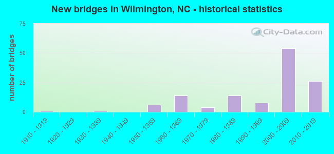
- New bridges - historical statistics
- 11910-1919
- 11930-1939
- 61950-1959
- 141960-1969
- 41970-1979
- 141980-1989
- 81990-1999
- 542000-2009
- 262010-2019
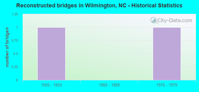
- Reconstructed bridges - Historical Statistics
- 11950-1959
- 01960-1969
- 11970-1979
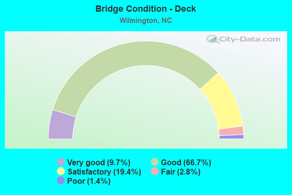
- Bridge Condition - Deck
- 9.7%Very good
- 66.7%Good
- 19.4%Satisfactory
- 2.8%Fair
- 1.4%Poor
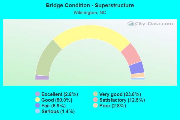
- Bridge Condition - Superstructure
- 2.8%Excellent
- 23.6%Very good
- 50.0%Good
- 12.5%Satisfactory
- 6.9%Fair
- 2.8%Poor
- 1.4%Serious
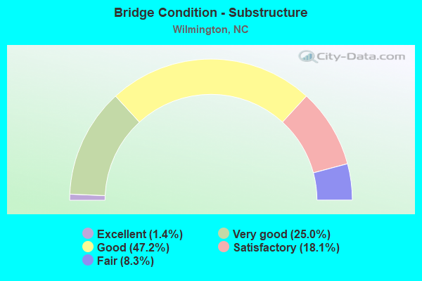
- Bridge Condition - Substructure
- 1.4%Excellent
- 25.0%Very good
- 47.2%Good
- 18.1%Satisfactory
- 8.3%Fair
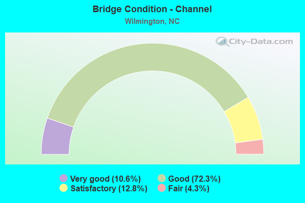
- Bridge Condition - Channel
- 10.6%Very good
- 72.3%Good
- 12.8%Satisfactory
- 4.3%Fair
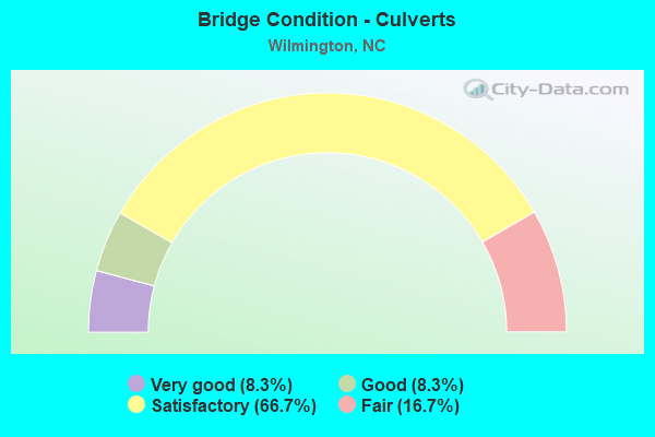
- Bridge Condition - Culverts
- 8.3%Very good
- 8.3%Good
- 66.7%Satisfactory
- 16.7%Fair
Find on map >> Show street view
Structure Number: 1290043, Location: 1.0 MI.E.JCT.SR1002 (Lat: 34.338703, Lng: -77.878394), Route carried "on" structure: Interstate 40, Year Built: 1983, Status: Open, Structure Length: 0.82m (2.69ft), Average Daily Traffic: 19,000 (year 2019), Truck Traffic: 16%, Average Future Daily Traffic: 38,000 (year 2040), Design Load: HS 20+Mod, Features Intersected: PRINCE GEORGE CREEK
Minimum Vertical Clearance: 30+ m (98+ ft), Kilometerpoint: 126.645, Lanes on structure: 4, Base Highway Network: Yes (Inventory Route: 1, Subroute: 40), Owner: State Highway Agency, Approaching Roadway Width: 24.0m (78.7ft), Skew: 4 degrees, Material/Design: Concrete continuous, Design/Construction: Culvert, Number Of Spans In Main Unit: 2, Length of Maximum Span: 2.7m (8.9ft)
Condition: Channel: Good, Culverts: Fair, Operating Rating: 42.6 metric tons, Method Used To Determine Operating Rating: Load and Resistance Factor (LRFR), Inventory Rating: 33.5 metric tons, Method Used To Determine Inventory Rating: Load and Resistance Factor (LRFR), Structural Evaluation: Somewhat better than minimum adequacy, Waterway Adequacy: Better than present minimum criteria, Approach Roadway Alignment: Equal to present desirable criteria, Designated Inspection Frequency: Every 24 months, Underwater Inspection Frequency: Every 60 months, Inspection Date: November 2020, Underwater Inspection Date: November 2020
Find on map >> Show street view
Structure Number: 1290046, Location: 0.5 MI. W. OF JCT.SR1002 (Lat: 34.358236, Lng: -77.887167), Route carried "on" structure: Interstate 40, Year Built: 1984, Status: Open, Structure Length: 3.56m (11.68ft), Average Daily Traffic: 19,000 (year 2019), Truck Traffic: 16%, Average Future Daily Traffic: 38,000 (year 2040), Design Load: HS 20+Mod, Features Intersected: RR
Minimum Vertical Clearance: 30+ m (98+ ft), Kilometerpoint: 126.188, Lanes on structure: 2, Base Highway Network: Yes (Inventory Route: 1, Subroute: 40), Owner: State Highway Agency, Approaching Roadway Width: 12.8m (42.0ft), Skew: 10 degrees, Material/Design: Prestressed concrete, Design/Construction: Slab, Number Of Spans In Main Unit: 3, Length of Maximum Span: 11.8m (38.7ft), Curb-To-Curb Width: 12.8m (42.0ft), Out-to-Out Width: 13.7m (44.9ft)
Condition: Deck: Satisfactory, Superstructure: Satisfactory, Substructure: Satisfactory, Operating Rating: 62.5 metric tons, Method Used To Determine Operating Rating: Load Factor (LF), Inventory Rating: 37.1 metric tons, Method Used To Determine Inventory Rating: Load Factor (LF), Structural Evaluation: Equal to present minimum criteria, Deck Geometry: Equal to present desirable criteria, Underclear: Somewhat better than minimum adequacy, Approach Roadway Alignment: Equal to present desirable criteria, Designated Inspection Frequency: Every 24 months, Inspection Date: November 2020, Deck Structure Type: Concrete Precast Panels, Wearing Surface/Protective System: Wearing Surface: Bituminous
Find on map >> Show street view
Structure Number: 129005, Location: 0.2 MI. W. END. US421 (Lat: 33.961406, Lng: -77.939797), Route carried "on" structure: US 421, Year Built: 1964, Status: Open, Structure Length: 4.23m (13.88ft), Average Daily Traffic: 1,100 (year 2019), Truck Traffic: 6%, Average Future Daily Traffic: 2,200 (year 2040), Design Load: HS 20+Mod, Features Intersected: CAPE FEAR RIVER
Minimum Vertical Clearance: 4.67m (15.32ft), Kilometerpoint: 0.000, Lanes on structure: 1, Base Highway Network: Yes (Inventory Route: 2, Subroute: 21), Owner: State Highway Agency, Approaching Roadway Width: 9.7m (31.8ft), Material/Design: Steel, Design/Construction: Truss - Thru, Number Of Spans In Main Unit: 1, Number Of Approach Spans: 2, Length of Maximum Span: 6.0m (19.7ft), Curb-To-Curb Width: 4.3m (14.1ft), Out-to-Out Width: 5.5m (18.0ft)
Condition: Deck: Good, Superstructure: Good, Substructure: Good, Channel: Good, Operating Rating: 56.2 metric tons, Method Used To Determine Operating Rating: Load Factor (LF), Inventory Rating: 38.1 metric tons, Method Used To Determine Inventory Rating: Load Factor (LF), Structural Evaluation: Better than present minimum criteria, Deck Geometry: High priority of replacement, Waterway Adequacy: Better than present minimum criteria, Approach Roadway Alignment: Better than present minimum criteria, Designated Inspection Frequency: Every 24 months, Critical Feature Inspection Frequency: Every 24 months, Underwater Inspection Frequency: Every 60 months, Inspection Date: August 2020, Critical Feature Inspection Date: August 2020, Underwater Inspection Date: August 2020, Deck Structure Type: Open Grating, Wearing Surface/Protective System: Wearing Surface: Other
Find on map >> Show street view
Structure Number: 1290058, Location: JCT. OF I40 & SR2048 (Lat: 34.277697, Lng: -77.868236), Route carried "on" structure: Interstate 40, Year Built: 1985, Status: Open, Structure Length: 5.21m (17.09ft), Average Daily Traffic: 25,500 (year 2019), Truck Traffic: 16%, Average Future Daily Traffic: 51,000 (year 2040), Design Load: HS 20+Mod, Features Intersected: SR2048 (GORDON ROAD)
Minimum Vertical Clearance: 30+ m (98+ ft), Kilometerpoint: 128.017, Lanes on structure: 3, Lanes under structure: 5, Base Highway Network: Yes (Inventory Route: 1, Subroute: 40), Owner: State Highway Agency, Approaching Roadway Width: 14.3m (46.9ft), Skew: 13 degrees, Material/Design: Steel, Design/Construction: Stringer/Multi-beam, Number Of Spans In Main Unit: 3, Length of Maximum Span: 31.6m (103.7ft), Curb-To-Curb Width: 13.9m (45.6ft), Out-to-Out Width: 14.8m (48.6ft)
Condition: Deck: Good, Superstructure: Good, Substructure: Good, Operating Rating: 77.1 metric tons, Method Used To Determine Operating Rating: Load Factor (LF), Inventory Rating: 46.2 metric tons, Method Used To Determine Inventory Rating: Load Factor (LF), Structural Evaluation: Better than present minimum criteria, Deck Geometry: Meets minimum limits, Underclear: Meets minimum limits, Approach Roadway Alignment: Equal to present desirable criteria, Designated Inspection Frequency: Every 24 months, Inspection Date: December 2020, Deck Structure Type: Concrete Cast-file-Place, Wearing Surface/Protective System: Wearing Surface: Monolithic Concrete
Find on map >> Show street view
Structure Number: 129007, Location: 0.2 MI.S. OF JCT.SR1322 (Lat: 34.293703, Lng: -77.845858), Route carried "on" structure: State highway 2234, Year Built: 1990, Status: Open, Structure Length: 0.64m (2.10ft), Average Daily Traffic: 500 (year 1989), Truck Traffic: 7%, Average Future Daily Traffic: 1,000 (year 2040), Design Load: HS 20+Mod, Features Intersected: SMITH CREEK
Minimum Vertical Clearance: 30+ m (98+ ft), Kilometerpoint: 0.000, Lanes on structure: 2, Owner: State Highway Agency, Approaching Roadway Width: 6.0m (19.7ft), Material/Design: Steel, Design/Construction: Culvert, Number Of Spans In Main Unit: 2, Length of Maximum Span: 2.7m (8.9ft)
Condition: Channel: Good, Culverts: Satisfactory, Operating Rating: 78.9 metric tons, Method Used To Determine Operating Rating: Load and Resistance Factor (LRFR), Inventory Rating: 60.7 metric tons, Method Used To Determine Inventory Rating: Load and Resistance Factor (LRFR), Structural Evaluation: Equal to present minimum criteria, Waterway Adequacy: Better than present minimum criteria, Approach Roadway Alignment: Equal to present desirable criteria, Designated Inspection Frequency: Every 24 months, Inspection Date: December 2020
Find on map >> Show street view
Structure Number: 1290078, Location: 0.01 MI. S. OF SR1241 (Lat: 34.139478, Lng: -77.909594), Route carried "on" structure: State highway 1242, Year Built: 1960, Status: Posted for load, Structure Length: 1.52m (4.99ft), Average Daily Traffic: 100 (year 2013), Truck Traffic: 7%, Average Future Daily Traffic: 200 (year 2040), Design Load: H 15, Features Intersected: MOTT CREEK
Minimum Vertical Clearance: 30+ m (98+ ft), Kilometerpoint: 0.000, Lanes on structure: 2, Owner: State Highway Agency, Approaching Roadway Width: 6.4m (21.0ft), Material/Design: Prestressed concrete, Design/Construction: Channel Beam, Number Of Spans In Main Unit: 2, Length of Maximum Span: 7.3m (24.0ft), Curb or Sidewalk Widths: Left: 0.1m (0.3ft), Right: 0.1m (0.3ft), Curb-To-Curb Width: 7.3m (24.0ft), Out-to-Out Width: 7.7m (25.3ft)
Condition: Deck: Satisfactory, Superstructure: Satisfactory, Substructure: Satisfactory, Channel: Good, Operating Rating: 26.3 metric tons, Method Used To Determine Operating Rating: Allowable Stress (AS), Inventory Rating: 9.9 metric tons, Method Used To Determine Inventory Rating: Allowable Stress (AS), Structural Evaluation: High priority of corrective action, Deck Geometry: Equal to present minimum criteria, Waterway Adequacy: Better than present minimum criteria, Approach Roadway Alignment: Equal to present desirable criteria, Bridge Posting: Required (Relationship of Operating Rating to Maximum Legal Load: 20.0 - 29.9% below), Designated Inspection Frequency: Every 24 months, Inspection Date: January 2021, Deck Structure Type: Concrete Cast-file-Place, Wearing Surface/Protective System: Wearing Surface: Bituminous
Find on map >> Show street view
Structure Number: 1290079, Location: 0.1MI.E.JCT.W.COLLEGE ST. (Lat: 34.194611, Lng: -77.888361), Route carried "on" structure: City street , Year Built: 1993, Status: Open, Structure Length: 0.76m (2.49ft), Average Daily Traffic: 10,000 (year 2013), Truck Traffic: 7%, Average Future Daily Traffic: 20,000 (year 2040), Design Load: HS 20, Features Intersected: HEWLETT'S CREEK, Facility Carried by Structure: HOLLY TREE RD.
Minimum Vertical Clearance: 30+ m (98+ ft), Kilometerpoint: 0.000, Lanes on structure: 3, Owner: City or Municipal Highway Agency, Approaching Roadway Width: 12.8m (42.0ft), Material/Design: Concrete continuous, Design/Construction: Culvert, Number Of Spans In Main Unit: 3, Length of Maximum Span: 2.4m (7.9ft), Curb or Sidewalk Widths: Left: 0.0m, Right: 1.5m (4.9ft)
Condition: Channel: Satisfactory, Culverts: Satisfactory, Operating Rating: 41.7 metric tons, Method Used To Determine Operating Rating: Field evaluation and documented engineering judgment, Inventory Rating: 32.6 metric tons, Method Used To Determine Inventory Rating: Field evaluation and documented engineering judgment, Structural Evaluation: Equal to present minimum criteria, Waterway Adequacy: Better than present minimum criteria, Approach Roadway Alignment: Equal to present desirable criteria, Designated Inspection Frequency: Every 24 months, Inspection Date: April 2020
Find on map >> Show street view
Structure Number: 129008, Location: 0.1MI.N.JCT.US74,76 (Lat: 34.220028, Lng: -77.814306), Route carried "on" structure: City street , Year Built: 1995, Status: Open, Structure Length: 0.97m (3.18ft), Average Daily Traffic: 100 (year 1995), Average Future Daily Traffic: 200 (year 2025), Design Load: HS 20, Features Intersected: CREEK, Facility Carried by Structure: SUMMER REST RD.
Minimum Vertical Clearance: 30+ m (98+ ft), Kilometerpoint: 0.000, Lanes on structure: 2, Owner: City or Municipal Highway Agency, Approaching Roadway Width: 5.7m (18.7ft), Material/Design: Prestressed concrete, Design/Construction: Slab, Number Of Spans In Main Unit: 1, Length of Maximum Span: 8.8m (28.9ft), Curb-To-Curb Width: 8.2m (26.9ft), Out-to-Out Width: 9.1m (29.9ft)
Condition: Deck: Good, Superstructure: Good, Substructure: Good, Channel: Good, Operating Rating: 88.9 metric tons, Method Used To Determine Operating Rating: Load Factor (LF), Inventory Rating: 52.6 metric tons, Method Used To Determine Inventory Rating: Load Factor (LF), Structural Evaluation: Better than present minimum criteria, Deck Geometry: Equal to present minimum criteria, Waterway Adequacy: Better than present minimum criteria, Approach Roadway Alignment: Equal to present desirable criteria, Designated Inspection Frequency: Every 24 months, Inspection Date: April 2020, Deck Structure Type: Concrete Precast Panels, Wearing Surface/Protective System: Wearing Surface: Bituminous
Find on map >> Show street view
Structure Number: 1290095, Location: 4.0 MI. S. JCT. US17 (Lat: 34.318569, Lng: -77.871822), Route carried "on" structure: Ramp Interstate 140, Year Built: 2004, Status: Open, Structure Length: 8.38m (27.49ft), Average Daily Traffic: 13,250 (year 2018), Truck Traffic: 16%, Average Future Daily Traffic: 26,500 (year 2040), Design Load: HS 20+Mod, Features Intersected: I-40
Minimum Vertical Clearance: 30+ m (98+ ft), Kilometerpoint: 6.096, Lanes on structure: 1, Lanes under structure: 7, Base Highway Network: Yes (Inventory Route: 1, Subroute: 40), Owner: State Highway Agency, Approaching Roadway Width: 11.2m (36.7ft), Skew: 10 degrees, Material/Design: Steel continuous, Design/Construction: Stringer/Multi-beam, Number Of Spans In Main Unit: 3, Length of Maximum Span: 32.0m (105.0ft), Curb-To-Curb Width: 11.1m (36.4ft), Out-to-Out Width: 12.1m (39.7ft)
Condition: Deck: Good, Superstructure: Good, Substructure: Good, Operating Rating: 89.8 metric tons, Method Used To Determine Operating Rating: Load Factor (LF), Inventory Rating: 55.3 metric tons, Method Used To Determine Inventory Rating: Load Factor (LF), Structural Evaluation: Better than present minimum criteria, Deck Geometry: High priority of corrective action, Underclear: Equal to present minimum criteria, Approach Roadway Alignment: Equal to present desirable criteria, Designated Inspection Frequency: Every 24 months, Inspection Date: January 2021, Deck Structure Type: Concrete Cast-file-Place, Wearing Surface/Protective System: Wearing Surface: Monolithic Concrete, Deck Protection: Epoxy Coated Reinforcing
Find on map >> Show street view
Structure Number: 1290098, Location: 5MI. S. JCT US17 (Lat: 34.319094, Lng: -77.869389), Route carried "on" structure: Ramp Interstate 140, Year Built: 2004, Status: Open, Structure Length: 3.93m (12.89ft), Average Daily Traffic: 8,833 (year 2018), Truck Traffic: 16%, Average Future Daily Traffic: 17,666 (year 2040), Design Load: HS 20+Mod, Features Intersected: I40W RAMP
Minimum Vertical Clearance: 30+ m (98+ ft), Kilometerpoint: 6.096, Lanes on structure: 1, Lanes under structure: 1, Base Highway Network: Yes, Owner: State Highway Agency, Approaching Roadway Width: 7.6m (24.9ft), Skew: 10 degrees, Material/Design: Steel, Design/Construction: Stringer/Multi-beam, Number Of Spans In Main Unit: 1, Number Of Approach Spans: 2, Length of Maximum Span: 38.1m (125.0ft), Curb-To-Curb Width: 7.5m (24.6ft), Out-to-Out Width: 8.4m (27.6ft)
Condition: Deck: Good, Superstructure: Good, Substructure: Good, Operating Rating: 89.8 metric tons, Method Used To Determine Operating Rating: Load Factor (LF), Inventory Rating: 66.2 metric tons, Method Used To Determine Inventory Rating: Load Factor (LF), Structural Evaluation: Better than present minimum criteria, Deck Geometry: Better than present minimum criteria, Underclear: Superior to present desirable criteria, Approach Roadway Alignment: Equal to present desirable criteria, Designated Inspection Frequency: Every 24 months, Inspection Date: Febuary 2021, Deck Structure Type: Concrete Cast-file-Place, Wearing Surface/Protective System: Wearing Surface: Monolithic Concrete, Deck Protection: Epoxy Coated Reinforcing
Find on map >> Show street view
Structure Number: 1290099, Location: 5MI. S. JCT US17 (Lat: 34.318914, Lng: -77.869389), Route carried "on" structure: Bypass US 17, Year Built: 2004, Status: Open, Structure Length: 3.81m (12.50ft), Average Daily Traffic: 10,000 (year 2018), Truck Traffic: 12%, Average Future Daily Traffic: 20,000 (year 2040), Design Load: HS 20+Mod, Features Intersected: I40 RAMP W
Minimum Vertical Clearance: 30+ m (98+ ft), Kilometerpoint: 6.096, Lanes on structure: 2, Lanes under structure: 1, Base Highway Network: Yes (Inventory Route: 2, Subroute: 17), Owner: State Highway Agency, Approaching Roadway Width: 11.5m (37.7ft), Skew: 10 degrees, Material/Design: Steel, Design/Construction: Stringer/Multi-beam, Number Of Spans In Main Unit: 1, Length of Maximum Span: 37.4m (122.7ft), Curb-To-Curb Width: 11.2m (36.7ft), Out-to-Out Width: 12.0m (39.4ft)
Condition: Deck: Good, Superstructure: Good, Substructure: Good, Operating Rating: 89.8 metric tons, Method Used To Determine Operating Rating: Load Factor (LF), Inventory Rating: 61.6 metric tons, Method Used To Determine Inventory Rating: Load Factor (LF), Structural Evaluation: Better than present minimum criteria, Deck Geometry: Somewhat better than minimum adequacy, Underclear: Superior to present desirable criteria, Approach Roadway Alignment: Equal to present desirable criteria, Designated Inspection Frequency: Every 24 months, Inspection Date: Febuary 2021, Deck Structure Type: Concrete Cast-file-Place, Wearing Surface/Protective System: Wearing Surface: Monolithic Concrete, Deck Protection: Epoxy Coated Reinforcing
Find on map >> Show street view
Structure Number: 1290101, Location: @ JCT.I40 (Lat: 34.316758, Lng: -77.871650), Route carried "on" structure: Ramp Interstate 40, Year Built: 2005, Status: Open, Structure Length: 8.01m (26.28ft), Average Daily Traffic: 5,000 (year 2015), Truck Traffic: 16%, Average Future Daily Traffic: 10,000 (year 2025), Design Load: HS 20+Mod, Features Intersected: I40
Minimum Vertical Clearance: 30+ m (98+ ft), Kilometerpoint: 6.096, Lanes on structure: 1, Lanes under structure: 5, Owner: State Highway Agency, Approaching Roadway Width: 11.2m (36.7ft), Material/Design: Steel continuous, Design/Construction: Stringer/Multi-beam, Number Of Spans In Main Unit: 3, Length of Maximum Span: 30.1m (98.8ft), Curb-To-Curb Width: 11.2m (36.7ft), Out-to-Out Width: 12.3m (40.4ft)
Condition: Deck: Good, Superstructure: Very good, Substructure: Good, Operating Rating: 65.3 metric tons, Method Used To Determine Operating Rating: Load Factor (LF), Inventory Rating: 39.0 metric tons, Method Used To Determine Inventory Rating: Load Factor (LF), Structural Evaluation: Better than present minimum criteria, Deck Geometry: Superior to present desirable criteria, Underclear: Equal to present minimum criteria, Approach Roadway Alignment: Equal to present desirable criteria, Designated Inspection Frequency: Every 24 months, Inspection Date: Febuary 2021, Deck Structure Type: Concrete Cast-file-Place, Wearing Surface/Protective System: Wearing Surface: Monolithic Concrete, Deck Protection: Epoxy Coated Reinforcing
Find on map >> Show street view
Structure Number: 1290103, Location: 2.5 MI. S. OF JCT. NC133 (Lat: 34.289325, Lng: -77.968392), Route carried "on" structure: Interstate 140, Year Built: 2007, Status: Open, Structure Length: 225.61m (740.19ft), Average Daily Traffic: 23,500 (year 2019), Truck Traffic: 16%, Average Future Daily Traffic: 47,000 (year 2040), Design Load: HS 20+Mod, Features Intersected: US421/NE CAPE FEAR RIVER
Minimum Vertical Clearance: 5.43m (17.81ft), Kilometerpoint: 4.419, Lanes on structure: 4, Lanes under structure: 8, Base Highway Network: Yes (Inventory Route: 1, Subroute: 40), Owner: State Highway Agency, Approaching Roadway Width: 26.5m (86.9ft), Skew: 30 degrees, Navigation Control: Yes ( Vertical Clearance: 19.8m (65.0ft), Horizontal Clearance: 27.4m (89.9ft)), Material/Design: Prestressed concrete continuous, Design/Construction: Segmental Box Girder, Number Of Spans In Main Unit: 3, Number Of Approach Spans: 58, Length of Maximum Span: 146.0m (479.0ft), Curb-To-Curb Width: 27.5m (90.2ft), Out-to-Out Width: 32.7m (107.3ft)
Condition: Deck: Good, Superstructure: Satisfactory, Substructure: Good, Channel: Good, Operating Rating: 89.8 metric tons, Method Used To Determine Operating Rating: Load Factor (LF), Inventory Rating: 68.0 metric tons, Method Used To Determine Inventory Rating: Load Factor (LF), Structural Evaluation: Equal to present minimum criteria, Deck Geometry: Superior to present desirable criteria, Underclear: Equal to present minimum criteria, Waterway Adequacy: Better than present minimum criteria, Approach Roadway Alignment: Equal to present desirable criteria, Designated Inspection Frequency: Every 24 months, Underwater Inspection Frequency: Every 60 months, Inspection Date: March 2020, Underwater Inspection Date: August 2021, Deck Structure Type: Concrete Precast Panels, Wearing Surface/Protective System: Wearing Surface: Monolithic Concrete
Find on map >> Show street view
Structure Number: 1290104, Location: 1.7MI. S. JCT.NC133 (Lat: 34.309314, Lng: -77.950161), Route carried "on" structure: Interstate 140, Year Built: 2007, Status: Open, Structure Length: 3.87m (12.70ft), Average Daily Traffic: 11,750 (year 2019), Truck Traffic: 16%, Average Future Daily Traffic: 23,500 (year 2040), Design Load: HS 20+Mod, Features Intersected: SR1331
Minimum Vertical Clearance: 30+ m (98+ ft), Kilometerpoint: 4.876, Lanes on structure: 2, Lanes under structure: 2, Base Highway Network: Yes (Inventory Route: 1, Subroute: 40), Owner: State Highway Agency, Approaching Roadway Width: 11.2m (36.7ft), Skew: 12 degrees, Material/Design: Prestressed concrete continuous, Design/Construction: Stringer/Multi-beam, Number Of Spans In Main Unit: 3, Number Of Approach Spans: 2, Length of Maximum Span: 13.1m (43.0ft), Curb-To-Curb Width: 11.2m (36.7ft), Out-to-Out Width: 12.3m (40.4ft)
Condition: Deck: Good, Superstructure: Good, Substructure: Good, Operating Rating: 89.8 metric tons, Method Used To Determine Operating Rating: Load Factor (LF), Inventory Rating: 67.1 metric tons, Method Used To Determine Inventory Rating: Load Factor (LF), Structural Evaluation: Better than present minimum criteria, Deck Geometry: High priority of corrective action, Underclear: High priority of corrective action, Approach Roadway Alignment: Equal to present desirable criteria, Designated Inspection Frequency: Every 24 months, Inspection Date: Febuary 2021, Deck Structure Type: Concrete Cast-file-Place, Wearing Surface/Protective System: Wearing Surface: Monolithic Concrete, Deck Protection: Epoxy Coated Reinforcing
Find on map >> Show street view
Structure Number: 1290105, Location: 1.7 MI.S.JCT.US117/NC133 (Lat: 34.309347, Lng: -77.950400), Route carried "on" structure: Interstate 140, Year Built: 2007, Status: Open, Structure Length: 3.87m (12.70ft), Average Daily Traffic: 11,750 (year 2019), Truck Traffic: 16%, Average Future Daily Traffic: 23,500 (year 2040), Design Load: HS 20+Mod, Features Intersected: SR1331
Minimum Vertical Clearance: 30+ m (98+ ft), Kilometerpoint: 4.876, Lanes on structure: 2, Lanes under structure: 2, Base Highway Network: Yes (Inventory Route: 1, Subroute: 40), Owner: State Highway Agency, Approaching Roadway Width: 10.9m (35.8ft), Skew: 12 degrees, Material/Design: Prestressed concrete continuous, Design/Construction: Stringer/Multi-beam, Number Of Spans In Main Unit: 3, Length of Maximum Span: 12.8m (42.0ft), Curb-To-Curb Width: 11.0m (36.1ft), Out-to-Out Width: 12.2m (40.0ft)
Condition: Deck: Good, Superstructure: Good, Substructure: Good, Operating Rating: 89.8 metric tons, Method Used To Determine Operating Rating: Load Factor (LF), Inventory Rating: 68.0 metric tons, Method Used To Determine Inventory Rating: Load Factor (LF), Structural Evaluation: Better than present minimum criteria, Deck Geometry: High priority of corrective action, Underclear: High priority of corrective action, Approach Roadway Alignment: Equal to present desirable criteria, Designated Inspection Frequency: Every 24 months, Inspection Date: Febuary 2021, Deck Structure Type: Concrete Cast-file-Place, Wearing Surface/Protective System: Wearing Surface: Monolithic Concrete, Deck Protection: Epoxy Coated Reinforcing
Find on map >> Show street view
Structure Number: 1290107, Location: .5 Ml. S. MCRAE STREET (Lat: 34.250589, Lng: -77.947444), Route carried "on" structure: US 74, Year Built: 2003, Status: Open, Structure Length: 6.15m (20.18ft), Average Daily Traffic: 18,750 (year 2019), Truck Traffic: 12%, Average Future Daily Traffic: 37,500 (year 2040), Design Load: HS 20+Mod, Features Intersected: CSX RAIL ROAD
Minimum Vertical Clearance: 30+ m (98+ ft), Kilometerpoint: 0.000, Lanes on structure: 6, Base Highway Network: Yes (Inventory Route: 2, Subroute: 74), Owner: State Highway Agency, Approaching Roadway Width: 28.6m (93.8ft), Skew: 24 degrees, Material/Design: Prestressed concrete, Design/Construction: Stringer/Multi-beam, Number Of Spans In Main Unit: 2, Length of Maximum Span: 30.1m (98.8ft), Curb-To-Curb Width: 28.2m (92.5ft), Out-to-Out Width: 30.3m (99.4ft)
Condition: Deck: Good, Superstructure: Good, Substructure: Good, Operating Rating: 89.8 metric tons, Method Used To Determine Operating Rating: Load Factor (LF), Inventory Rating: 37.1 metric tons, Method Used To Determine Inventory Rating: Load Factor (LF), Structural Evaluation: Better than present minimum criteria, Deck Geometry: Superior to present desirable criteria, Underclear: Superior to present desirable criteria, Approach Roadway Alignment: Equal to present desirable criteria, Designated Inspection Frequency: Every 24 months, Inspection Date: December 2020, Deck Structure Type: Concrete Cast-file-Place, Wearing Surface/Protective System: Wearing Surface: Monolithic Concrete, Deck Protection: Epoxy Coated Reinforcing
Find on map >> Show street view
Structure Number: 1290108, Location: JCT.US74 & RMP BD (Lat: 34.251136, Lng: -77.947239), Route carried "on" structure: US 74, Year Built: 2003, Status: Open, Structure Length: 4.99m (16.37ft), Average Daily Traffic: 9,500 (year 2019), Truck Traffic: 12%, Average Future Daily Traffic: 19,000 (year 2040), Design Load: HS 20+Mod, Features Intersected: RAMP BD(US74)
Minimum Vertical Clearance: 30+ m (98+ ft), Kilometerpoint: 0.000, Lanes on structure: 4, Lanes under structure: 1, Base Highway Network: Yes (Inventory Route: 2, Subroute: 74), Owner: State Highway Agency, Approaching Roadway Width: 12.4m (40.7ft), Skew: 35 degrees, Material/Design: Prestressed concrete, Design/Construction: Stringer/Multi-beam, Number Of Spans In Main Unit: 2, Length of Maximum Span: 24.6m (80.7ft), Curb-To-Curb Width: 26.7m (87.6ft), Out-to-Out Width: 30.3m (99.4ft)
Condition: Deck: Good, Superstructure: Good, Substructure: Good, Operating Rating: 88.9 metric tons, Method Used To Determine Operating Rating: Load Factor (LF), Inventory Rating: 46.2 metric tons, Method Used To Determine Inventory Rating: Load Factor (LF), Structural Evaluation: Better than present minimum criteria, Deck Geometry: Superior to present desirable criteria, Underclear: Somewhat better than minimum adequacy, Approach Roadway Alignment: Equal to present desirable criteria, Designated Inspection Frequency: Every 24 months, Inspection Date: January 2021, Deck Structure Type: Concrete Cast-file-Place, Wearing Surface/Protective System: Wearing Surface: Monolithic Concrete, Deck Protection: Epoxy Coated Reinforcing
Find on map >> Show street view
Structure Number: 1290109, Location: JCT. US117 & SMITH CRK (Lat: 34.251472, Lng: -77.948225), Route carried "on" structure: Ramp State highway 133, Year Built: 2003, Status: Open, Structure Length: 18.65m (61.19ft), Average Daily Traffic: 15,000 (year 2018), Truck Traffic: 12%, Average Future Daily Traffic: 30,000 (year 2040), Design Load: HL 93, Features Intersected: WET LANDS
Minimum Vertical Clearance: 30+ m (98+ ft), Kilometerpoint: 0.000, Lanes on structure: 2, Base Highway Network: Yes, Owner: State Highway Agency, Approaching Roadway Width: 10.3m (33.8ft), Material/Design: Prestressed concrete continuous, Design/Construction: Stringer/Multi-beam, Number Of Spans In Main Unit: 7, Length of Maximum Span: 25.9m (85.0ft), Curb-To-Curb Width: 10.1m (33.1ft), Out-to-Out Width: 11.1m (36.4ft)
Condition: Deck: Good, Superstructure: Good, Substructure: Good, Channel: Good, Operating Rating: 68.9 metric tons, Method Used To Determine Operating Rating: Load and Resistance Factor (LRFR), Inventory Rating: 52.6 metric tons, Method Used To Determine Inventory Rating: Load and Resistance Factor (LRFR), Structural Evaluation: Better than present minimum criteria, Deck Geometry: Equal to present minimum criteria, Waterway Adequacy: Better than present minimum criteria, Approach Roadway Alignment: Equal to present desirable criteria, Designated Inspection Frequency: Every 24 months, Inspection Date: January 2021, Deck Structure Type: Concrete Cast-file-Place, Wearing Surface/Protective System: Wearing Surface: Monolithic Concrete, Deck Protection: Epoxy Coated Reinforcing
Find on map >> Show street view
Structure Number: 1290111, Location: .5 MI.E.OF JCT US17&US421 (Lat: 34.250686, Lng: -77.948200), Route carried "on" structure: Ramp State highway 1627, Year Built: 2005, Status: Open, Structure Length: 11.24m (36.88ft), Average Daily Traffic: 9,000 (year 2018), Truck Traffic: 12%, Average Future Daily Traffic: 18,000 (year 2040), Design Load: HS 20+Mod, Features Intersected: US74, NC133
Minimum Vertical Clearance: 5.33m (17.49ft), Kilometerpoint: 0.000, Lanes on structure: 1, Lanes under structure: 1, Owner: State Highway Agency, Approaching Roadway Width: 9.1m (29.9ft), Material/Design: Prestressed concrete, Design/Construction: Stringer/Multi-beam, Number Of Spans In Main Unit: 5, Length of Maximum Span: 27.4m (89.9ft), Curb-To-Curb Width: 9.0m (29.5ft), Out-to-Out Width: 9.9m (32.5ft)
Condition: Deck: Very good, Superstructure: Very good, Substructure: Very good, Operating Rating: 89.8 metric tons, Method Used To Determine Operating Rating: Load Factor (LF), Inventory Rating: 50.8 metric tons, Method Used To Determine Inventory Rating: Load Factor (LF), Structural Evaluation: Equal to present desirable criteria, Deck Geometry: Superior to present desirable criteria, Underclear: Meets minimum limits, Approach Roadway Alignment: Equal to present desirable criteria, Designated Inspection Frequency: Every 24 months, Inspection Date: Febuary 2021, Deck Structure Type: Concrete Cast-file-Place, Wearing Surface/Protective System: Wearing Surface: Monolithic Concrete
Find on map >> Show street view
Structure Number: 1290112, Location: 1.0MI.E.JCT.US421 (Lat: 34.256189, Lng: -77.938644), Route carried "on" structure: US 74, Year Built: 2005, Status: Open, Structure Length: 94.39m (309.68ft), Average Daily Traffic: 22,250 (year 2019), Truck Traffic: 12%, Average Future Daily Traffic: 44,500 (year 2040), Design Load: HS 20+Mod, Features Intersected: MCRAE ST,CSXRR,SMITH CR.
Minimum Vertical Clearance: 7.01m (23.00ft), Kilometerpoint: 0.000, Lanes on structure: 2, Lanes under structure: 2, Base Highway Network: Yes (Inventory Route: 2, Subroute: 74), Owner: State Highway Agency, Approaching Roadway Width: 15.2m (49.9ft), Skew: 10 degrees, Material/Design: Prestressed concrete continuous, Design/Construction: Stringer/Multi-beam, Number Of Spans In Main Unit: 22, Number Of Approach Spans: 9, Length of Maximum Span: 42.3m (138.8ft), Curb-To-Curb Width: 11.4m (37.4ft), Out-to-Out Width: 15.9m (52.2ft)
Condition: Deck: Good, Superstructure: Good, Substructure: Satisfactory, Channel: Satisfactory, Operating Rating: 89.8 metric tons, Method Used To Determine Operating Rating: Load Factor (LF), Inventory Rating: 44.4 metric tons, Method Used To Determine Inventory Rating: Load Factor (LF), Structural Evaluation: Equal to present minimum criteria, Deck Geometry: Somewhat better than minimum adequacy, Underclear: High priority of corrective action, Waterway Adequacy: Equal to present desirable criteria, Approach Roadway Alignment: Equal to present desirable criteria, Designated Inspection Frequency: Every 24 months, Underwater Inspection Frequency: Every 60 months, Inspection Date: April 2021, Underwater Inspection Date: October 2021, Deck Structure Type: Concrete Cast-file-Place, Wearing Surface/Protective System: Wearing Surface: Monolithic Concrete, Deck Protection: Epoxy Coated Reinforcing
Find on map >> Show street view
Structure Number: 1290113, Location: 1.0 MI.E.JCT.US421 (Lat: 34.256336, Lng: -77.938700), Route carried "on" structure: US 74, Year Built: 2005, Status: Open, Structure Length: 93.54m (306.89ft), Average Daily Traffic: 22,250 (year 2019), Truck Traffic: 12%, Average Future Daily Traffic: 44,500 (year 2040), Design Load: HS 20+Mod, Features Intersected: MCRAE ST,CSXRR,SMITH CRK
Minimum Vertical Clearance: 5.63m (18.47ft), Kilometerpoint: 0.000, Lanes on structure: 2, Lanes under structure: 2, Base Highway Network: Yes (Inventory Route: 2, Subroute: 74), Owner: State Highway Agency, Approaching Roadway Width: 14.9m (48.9ft), Skew: 10 degrees, Material/Design: Prestressed concrete continuous, Design/Construction: Stringer/Multi-beam, Number Of Spans In Main Unit: 24, Number Of Approach Spans: 6, Length of Maximum Span: 42.3m (138.8ft), Curb-To-Curb Width: 11.3m (37.1ft), Out-to-Out Width: 17.5m (57.4ft)
Condition: Deck: Good, Superstructure: Good, Substructure: Satisfactory, Channel: Satisfactory, Operating Rating: 89.8 metric tons, Method Used To Determine Operating Rating: Load Factor (LF), Inventory Rating: 39.9 metric tons, Method Used To Determine Inventory Rating: Load Factor (LF), Structural Evaluation: Equal to present minimum criteria, Deck Geometry: Somewhat better than minimum adequacy, Underclear: High priority of corrective action, Waterway Adequacy: Better than present minimum criteria, Approach Roadway Alignment: Somewhat better than minimum adequacy, Designated Inspection Frequency: Every 24 months, Underwater Inspection Frequency: Every 60 months, Inspection Date: April 2021, Underwater Inspection Date: October 2021, Deck Structure Type: Concrete Cast-file-Place, Wearing Surface/Protective System: Wearing Surface: Monolithic Concrete, Deck Protection: Epoxy Coated Reinforcing
Find on map >> Show street view
Structure Number: 1290114, Location: JCT.US74 & MCRAE ST. (Lat: 34.256344, Lng: -77.940322), Route carried "on" structure: Ramp US 74, Year Built: 2005, Status: Open, Structure Length: 26.85m (88.09ft), Average Daily Traffic: 11,125 (year 2019), Truck Traffic: 12%, Average Future Daily Traffic: 22,250 (year 2040), Design Load: HS 20+Mod, Features Intersected: WET LANDS
Minimum Vertical Clearance: 30+ m (98+ ft), Kilometerpoint: 0.000, Lanes on structure: 1, Owner: State Highway Agency, Approaching Roadway Width: 8.2m (26.9ft), Skew: 9 degrees, Material/Design: Prestressed concrete continuous, Design/Construction: Stringer/Multi-beam, Number Of Spans In Main Unit: 11, Number Of Approach Spans: 1, Length of Maximum Span: 23.4m (76.8ft), Curb-To-Curb Width: 7.8m (25.6ft), Out-to-Out Width: 8.8m (28.9ft)
Condition: Deck: Good, Superstructure: Good, Substructure: Good, Operating Rating: 48.0 metric tons, Method Used To Determine Operating Rating: Load Factor (LF), Inventory Rating: 22.6 metric tons, Method Used To Determine Inventory Rating: Load Factor (LF), Structural Evaluation: Somewhat better than minimum adequacy, Deck Geometry: Better than present minimum criteria, Approach Roadway Alignment: Equal to present desirable criteria, Designated Inspection Frequency: Every 24 months, Inspection Date: Febuary 2021, Deck Structure Type: Concrete Cast-file-Place, Wearing Surface/Protective System: Wearing Surface: Monolithic Concrete, Deck Protection: Epoxy Coated Reinforcing
Find on map >> Show street view
Structure Number: 1290115, Location: 50' W.JCT.US74 & MCRAE ST (Lat: 34.255139, Lng: -77.939947), Route carried "on" structure: Ramp US 74, Year Built: 2005, Status: Open, Structure Length: 15.11m (49.57ft), Average Daily Traffic: 11,125 (year 2019), Truck Traffic: 12%, Average Future Daily Traffic: 22,250 (year 2040), Design Load: HS 20+Mod, Features Intersected: WETLAND OFF SMITH CR
Minimum Vertical Clearance: 30+ m (98+ ft), Kilometerpoint: 0.000, Lanes on structure: 1, Owner: State Highway Agency, Approaching Roadway Width: 7.9m (25.9ft), Material/Design: Prestressed concrete, Design/Construction: Stringer/Multi-beam, Number Of Spans In Main Unit: 4, Number Of Approach Spans: 2, Length of Maximum Span: 30.1m (98.8ft), Curb-To-Curb Width: 7.7m (25.3ft), Out-to-Out Width: 8.7m (28.5ft)
Condition: Deck: Very good, Superstructure: Very good, Substructure: Very good, Operating Rating: 89.8 metric tons, Method Used To Determine Operating Rating: Load Factor (LF), Inventory Rating: 52.6 metric tons, Method Used To Determine Inventory Rating: Load Factor (LF), Structural Evaluation: Equal to present desirable criteria, Deck Geometry: Better than present minimum criteria, Approach Roadway Alignment: Equal to present desirable criteria, Designated Inspection Frequency: Every 24 months, Inspection Date: Febuary 2021, Deck Structure Type: Concrete Cast-file-Place, Wearing Surface/Protective System: Wearing Surface: Monolithic Concrete, Deck Protection: Epoxy Coated Reinforcing
Find on map >> Show street view
Structure Number: 1290116, Location: @ JCT.US74 & NC133 (Lat: 34.256186, Lng: -77.938644), Route carried "on" structure: State highway 133, Year Built: 2008, Status: Open, Structure Length: 26.45m (86.78ft), Average Daily Traffic: 3,800 (year 2017), Truck Traffic: 12%, Average Future Daily Traffic: 7,600 (year 2040), Design Load: HS 20+Mod, Features Intersected: WETLANDS
Minimum Vertical Clearance: 5.68m (18.64ft), Kilometerpoint: 0.000, Lanes on structure: 2, Lanes under structure: 4, Owner: State Highway Agency, Approaching Roadway Width: 6.7m (22.0ft), Material/Design: Prestressed concrete, Design/Construction: Stringer/Multi-beam, Number Of Spans In Main Unit: 3, Number Of Approach Spans: 16, Length of Maximum Span: 14.3m (46.9ft), Curb or Sidewalk Widths: Left: 0.0m, Right: 1.5m (4.9ft), Curb-To-Curb Width: 8.3m (27.2ft), Out-to-Out Width: 10.7m (35.1ft)
Condition: Deck: Good, Superstructure: Very good, Substructure: Very good, Channel: Very good, Operating Rating: 63.5 metric tons, Method Used To Determine Operating Rating: Load Factor (LF), Inventory Rating: 30.8 metric tons, Method Used To Determine Inventory Rating: Load Factor (LF), Structural Evaluation: Better than present minimum criteria, Deck Geometry: High priority of corrective action, Underclear: Superior to present desirable criteria, Waterway Adequacy: Equal to present desirable criteria, Approach Roadway Alignment: Equal to present desirable criteria, Designated Inspection Frequency: Every 24 months, Inspection Date: March 2020, Deck Structure Type: Concrete Cast-file-Place, Wearing Surface/Protective System: Wearing Surface: Monolithic Concrete, Deck Protection: Epoxy Coated Reinforcing
Find on map >> Show street view
Structure Number: 1290117, Location: .1 MI. W. JCT. NC132 (Lat: 34.254981, Lng: -77.872903), Route carried "on" structure: US 74, Year Built: 1999, Status: Open, Structure Length: 0.97m (3.18ft), Average Daily Traffic: 25,500 (year 2019), Truck Traffic: 14%, Average Future Daily Traffic: 51,000 (year 2040), Design Load: HS 20+Mod, Features Intersected: SPRING BRANCH
Minimum Vertical Clearance: 30+ m (98+ ft), Kilometerpoint: 0.000, Lanes on structure: 6, Base Highway Network: Yes (Inventory Route: 2, Subroute: 74), Owner: State Highway Agency, Approaching Roadway Width: 38.4m (126.0ft), Skew: 4 degrees, Material/Design: Concrete continuous, Design/Construction: Culvert, Number Of Spans In Main Unit: 2, Length of Maximum Span: 3.3m (10.8ft)
Condition: Channel: Good, Culverts: Satisfactory, Operating Rating: 78.0 metric tons, Method Used To Determine Operating Rating: Load and Resistance Factor (LRFR), Inventory Rating: 59.8 metric tons, Method Used To Determine Inventory Rating: Load and Resistance Factor (LRFR), Structural Evaluation: Equal to present minimum criteria, Waterway Adequacy: Better than present minimum criteria, Approach Roadway Alignment: Equal to present desirable criteria, Designated Inspection Frequency: Every 24 months, Inspection Date: December 2020
Find on map >> Show street view
Structure Number: 129012, Location: .5MI.N.OF CASTLE HAYNE RD (Lat: 34.310875, Lng: -77.903511), Route carried "on" structure: Interstate 140, Year Built: 2005, Status: Open, Structure Length: 7.49m (24.57ft), Average Daily Traffic: 13,250 (year 2018), Truck Traffic: 16%, Average Future Daily Traffic: 26,500 (year 2040), Design Load: HS 20+Mod, Features Intersected: CSX RR
Minimum Vertical Clearance: 30+ m (98+ ft), Kilometerpoint: 5.791, Lanes on structure: 2, Base Highway Network: Yes (Inventory Route: 1, Subroute: 40), Owner: State Highway Agency, Approaching Roadway Width: 11.2m (36.7ft), Skew: 11 degrees, Material/Design: Prestressed concrete continuous, Design/Construction: Stringer/Multi-beam, Number Of Spans In Main Unit: 3, Length of Maximum Span: 24.9m (81.7ft), Curb-To-Curb Width: 11.2m (36.7ft), Out-to-Out Width: 12.2m (40.0ft)
Condition: Deck: Good, Superstructure: Good, Substructure: Good, Operating Rating: 86.1 metric tons, Method Used To Determine Operating Rating: Load Factor (LF), Inventory Rating: 51.7 metric tons, Method Used To Determine Inventory Rating: Load Factor (LF), Structural Evaluation: Better than present minimum criteria, Deck Geometry: Somewhat better than minimum adequacy, Underclear: Superior to present desirable criteria, Approach Roadway Alignment: Equal to present desirable criteria, Designated Inspection Frequency: Every 24 months, Inspection Date: January 2021, Deck Structure Type: Concrete Cast-file-Place, Wearing Surface/Protective System: Wearing Surface: Monolithic Concrete, Deck Protection: Epoxy Coated Reinforcing
Find on map >> Show street view
Structure Number: 1290121, Location: .5MI N OF CASTLE HAYNE RD (Lat: 34.310675, Lng: -77.903542), Route carried "on" structure: Interstate 140, Year Built: 2005, Status: Open, Structure Length: 7.71m (25.30ft), Average Daily Traffic: 13,250 (year 2018), Truck Traffic: 16%, Average Future Daily Traffic: 26,500 (year 2040), Design Load: HS 20+Mod, Features Intersected: CSXRR
Minimum Vertical Clearance: 30+ m (98+ ft), Kilometerpoint: 5.791, Lanes on structure: 2, Base Highway Network: Yes (Inventory Route: 1, Subroute: 40), Owner: State Highway Agency, Approaching Roadway Width: 11.2m (36.7ft), Skew: 11 degrees, Material/Design: Prestressed concrete, Design/Construction: Stringer/Multi-beam, Number Of Spans In Main Unit: 3, Length of Maximum Span: 26.2m (86.0ft), Curb-To-Curb Width: 11.3m (37.1ft), Out-to-Out Width: 12.2m (40.0ft)
Condition: Deck: Good, Superstructure: Good, Substructure: Good, Operating Rating: 84.3 metric tons, Method Used To Determine Operating Rating: Load Factor (LF), Inventory Rating: 40.8 metric tons, Method Used To Determine Inventory Rating: Load Factor (LF), Structural Evaluation: Better than present minimum criteria, Deck Geometry: Somewhat better than minimum adequacy, Underclear: Superior to present desirable criteria, Approach Roadway Alignment: Equal to present desirable criteria, Designated Inspection Frequency: Every 24 months, Inspection Date: January 2021, Deck Structure Type: Concrete Cast-file-Place, Wearing Surface/Protective System: Wearing Surface: Monolithic Concrete, Deck Protection: Epoxy Coated Reinforcing
Find on map >> Show street view
Structure Number: 1290126, Location: 0.1 MI. E. JCT SR1302 (Lat: 34.260956, Lng: -77.930536), Route carried "on" structure: US 74, Year Built: 2005, Status: Open, Structure Length: 4.48m (14.70ft), Average Daily Traffic: 22,250 (year 2019), Truck Traffic: 12%, Average Future Daily Traffic: 44,500 (year 2040), Design Load: HS 20+Mod, Features Intersected: US74(RAMP D)
Minimum Vertical Clearance: 30+ m (98+ ft), Kilometerpoint: 0.000, Lanes on structure: 2, Lanes under structure: 2, Base Highway Network: Yes (Inventory Route: 2, Subroute: 74), Owner: State Highway Agency, Approaching Roadway Width: 13.7m (44.9ft), Skew: 10 degrees, Material/Design: Prestressed concrete, Design/Construction: Stringer/Multi-beam, Number Of Spans In Main Unit: 3, Length of Maximum Span: 19.2m (63.0ft), Curb-To-Curb Width: 13.4m (44.0ft), Out-to-Out Width: 14.2m (46.6ft)
Condition: Deck: Good, Superstructure: Good, Substructure: Good, Operating Rating: 53.5 metric tons, Method Used To Determine Operating Rating: Load Factor (LF), Inventory Rating: 31.7 metric tons, Method Used To Determine Inventory Rating: Load Factor (LF), Structural Evaluation: Better than present minimum criteria, Deck Geometry: Superior to present desirable criteria, Underclear: High priority of corrective action, Approach Roadway Alignment: Equal to present desirable criteria, Designated Inspection Frequency: Every 24 months, Inspection Date: January 2021, Deck Structure Type: Concrete Cast-file-Place, Wearing Surface/Protective System: Wearing Surface: Monolithic Concrete, Deck Protection: Epoxy Coated Reinforcing
Find on map >> Show street view
Structure Number: 1290127, Location: JCT.US74,US117, NC133 (Lat: 34.260808, Lng: -77.930542), Route carried "on" structure: US 74, Year Built: 2005, Status: Open, Structure Length: 4.38m (14.37ft), Average Daily Traffic: 22,250 (year 2019), Truck Traffic: 12%, Average Future Daily Traffic: 44,500 (year 2040), Design Load: HS 20+Mod, Features Intersected: US74(RAMP D)
Minimum Vertical Clearance: 30+ m (98+ ft), Kilometerpoint: 0.000, Lanes on structure: 3, Lanes under structure: 2, Base Highway Network: Yes (Inventory Route: 2, Subroute: 74), Owner: State Highway Agency, Approaching Roadway Width: 15.2m (49.9ft), Skew: 10 degrees, Material/Design: Prestressed concrete continuous, Design/Construction: Stringer/Multi-beam, Number Of Spans In Main Unit: 3, Length of Maximum Span: 19.2m (63.0ft), Curb-To-Curb Width: 15.0m (49.2ft), Out-to-Out Width: 15.9m (52.2ft)
Condition: Deck: Good, Superstructure: Very good, Substructure: Good, Operating Rating: 67.1 metric tons, Method Used To Determine Operating Rating: Load Factor (LF), Inventory Rating: 39.9 metric tons, Method Used To Determine Inventory Rating: Load Factor (LF), Structural Evaluation: Better than present minimum criteria, Deck Geometry: Meets minimum limits, Underclear: High priority of corrective action, Approach Roadway Alignment: Equal to present desirable criteria, Designated Inspection Frequency: Every 24 months, Inspection Date: January 2021, Deck Structure Type: Concrete Cast-file-Place, Wearing Surface/Protective System: Wearing Surface: Monolithic Concrete, Deck Protection: Epoxy Coated Reinforcing
Find on map >> Show street view
Structure Number: 1290128, Location: 0.1M. E. JCT NC133 (Lat: 34.260661, Lng: -77.928117), Route carried "on" structure: US 74, Year Built: 2005, Status: Open, Structure Length: 4.99m (16.37ft), Average Daily Traffic: 20,500 (year 2017), Truck Traffic: 12%, Average Future Daily Traffic: 41,000 (year 2040), Design Load: HS 20+Mod, Features Intersected: CSX R/R
Minimum Vertical Clearance: 30+ m (98+ ft), Kilometerpoint: 0.000, Lanes on structure: 3, Base Highway Network: Yes (Inventory Route: 2, Subroute: 74), Owner: State Highway Agency, Approaching Roadway Width: 15.2m (49.9ft), Skew: 11 degrees, Material/Design: Prestressed concrete continuous, Design/Construction: Stringer/Multi-beam, Number Of Spans In Main Unit: 3, Length of Maximum Span: 19.8m (65.0ft), Curb-To-Curb Width: 14.9m (48.9ft), Out-to-Out Width: 15.9m (52.2ft)
Condition: Deck: Good, Superstructure: Good, Substructure: Very good, Operating Rating: 57.1 metric tons, Method Used To Determine Operating Rating: Load Factor (LF), Inventory Rating: 34.4 metric tons, Method Used To Determine Inventory Rating: Load Factor (LF), Structural Evaluation: Better than present minimum criteria, Deck Geometry: Meets minimum limits, Underclear: Superior to present desirable criteria, Approach Roadway Alignment: Equal to present desirable criteria, Designated Inspection Frequency: Every 24 months, Inspection Date: January 2021, Deck Structure Type: Concrete Cast-file-Place, Wearing Surface/Protective System: Wearing Surface: Integral Concrete, Deck Protection: Epoxy Coated Reinforcing
Find on map >> Show street view
Structure Number: 129013, Location: 0.5MI. E.. JCT MCRAE ST. (Lat: 34.258858, Lng: -77.929225), Route carried "on" structure: Ramp US 74, Year Built: 2005, Status: Open, Structure Length: 5.18m (16.99ft), Average Daily Traffic: 3,000 (year 2015), Truck Traffic: 12%, Average Future Daily Traffic: 6,000 (year 2040), Design Load: HS 20+Mod, Features Intersected: CSX RR
Minimum Vertical Clearance: 30+ m (98+ ft), Kilometerpoint: 0.000, Lanes on structure: 1, Owner: State Highway Agency, Approaching Roadway Width: 10.0m (32.8ft), Skew: 9 degrees, Material/Design: Prestressed concrete continuous, Design/Construction: Stringer/Multi-beam, Number Of Spans In Main Unit: 3, Length of Maximum Span: 20.1m (65.9ft), Curb-To-Curb Width: 9.4m (30.8ft), Out-to-Out Width: 10.3m (33.8ft)
Condition: Deck: Good, Superstructure: Good, Substructure: Very good, Operating Rating: 52.6 metric tons, Method Used To Determine Operating Rating: Load Factor (LF), Inventory Rating: 30.8 metric tons, Method Used To Determine Inventory Rating: Load Factor (LF), Structural Evaluation: Better than present minimum criteria, Deck Geometry: Superior to present desirable criteria, Underclear: Superior to present desirable criteria, Approach Roadway Alignment: Equal to present desirable criteria, Designated Inspection Frequency: Every 24 months, Inspection Date: January 2021, Deck Structure Type: Concrete Cast-file-Place, Wearing Surface/Protective System: Wearing Surface: Monolithic Concrete, Deck Protection: Epoxy Coated Reinforcing
Find on map >> Show street view
Structure Number: 1290131, Location: 0.60 MI. E. JCT.NC133 (Lat: 34.258569, Lng: -77.919708), Route carried "on" structure: US 74, Year Built: 2005, Status: Open, Structure Length: 65.92m (216.27ft), Average Daily Traffic: 22,750 (year 2019), Truck Traffic: 12%, Average Future Daily Traffic: 45,500 (year 2040), Design Load: HS 20+Mod, Features Intersected: SR1302 & SMITH CREEK
Minimum Vertical Clearance: 6.07m (19.91ft), Kilometerpoint: 0.000, Lanes on structure: 3, Lanes under structure: 5, Base Highway Network: Yes (Inventory Route: 2, Subroute: 74), Owner: State Highway Agency, Approaching Roadway Width: 14.9m (48.9ft), Skew: 19 degrees, Material/Design: Prestressed concrete continuous, Design/Construction: Stringer/Multi-beam, Number Of Spans In Main Unit: 15, Number Of Approach Spans: 6, Length of Maximum Span: 41.7m (136.8ft), Curb-To-Curb Width: 11.4m (37.4ft), Out-to-Out Width: 22.1m (72.5ft)
Condition: Deck: Good, Superstructure: Good, Substructure: Good, Channel: Good, Operating Rating: 89.8 metric tons, Method Used To Determine Operating Rating: Load Factor (LF), Inventory Rating: 48.0 metric tons, Method Used To Determine Inventory Rating: Load Factor (LF), Structural Evaluation: Better than present minimum criteria, Deck Geometry: High priority of replacement, Underclear: High priority of corrective action, Waterway Adequacy: Equal to present desirable criteria, Approach Roadway Alignment: Better than present minimum criteria, Designated Inspection Frequency: Every 24 months, Underwater Inspection Frequency: Every 60 months, Inspection Date: April 2021, Underwater Inspection Date: June 2021, Deck Structure Type: Concrete Cast-file-Place, Wearing Surface/Protective System: Wearing Surface: Monolithic Concrete, Deck Protection: Epoxy Coated Reinforcing
Find on map >> Show street view
Structure Number: 1290132, Location: @ JCT.SR1302 (Lat: 34.258419, Lng: -77.919714), Route carried "on" structure: US 74, Year Built: 2005, Status: Open, Structure Length: 65.86m (216.08ft), Average Daily Traffic: 22,750 (year 2019), Truck Traffic: 12%, Average Future Daily Traffic: 45,500 (year 2040), Design Load: HS 20+Mod, Features Intersected: SR1302,SMITH CREEK
Minimum Vertical Clearance: 5.46m (17.91ft), Kilometerpoint: 0.000, Lanes on structure: 3, Lanes under structure: 4, Base Highway Network: Yes (Inventory Route: 2, Subroute: 74), Owner: State Highway Agency, Approaching Roadway Width: 14.9m (48.9ft), Skew: 19 degrees, Material/Design: Prestressed concrete continuous, Design/Construction: Stringer/Multi-beam, Number Of Spans In Main Unit: 20, Number Of Approach Spans: 1, Length of Maximum Span: 41.4m (135.8ft), Curb-To-Curb Width: 15.0m (49.2ft), Out-to-Out Width: 15.9m (52.2ft)
Condition: Deck: Good, Superstructure: Good, Substructure: Good, Channel: Good, Operating Rating: 89.8 metric tons, Method Used To Determine Operating Rating: Load Factor (LF), Inventory Rating: 43.5 metric tons, Method Used To Determine Inventory Rating: Load Factor (LF), Structural Evaluation: Better than present minimum criteria, Deck Geometry: Meets minimum limits, Underclear: Equal to present minimum criteria, Waterway Adequacy: Better than present minimum criteria, Approach Roadway Alignment: Equal to present desirable criteria, Designated Inspection Frequency: Every 24 months, Underwater Inspection Frequency: Every 60 months, Inspection Date: April 2021, Underwater Inspection Date: June 2021, Deck Structure Type: Concrete Cast-file-Place, Wearing Surface/Protective System: Wearing Surface: Monolithic Concrete, Deck Protection: Epoxy Coated Reinforcing
Find on map >> Show street view
Structure Number: 1290133, Location: 0.1 MI.E. OF JCT. NC133 (Lat: 34.260144, Lng: -77.923181), Route carried "on" structure: Ramp US 74, Year Built: 2005, Status: Open, Structure Length: 15.30m (50.20ft), Average Daily Traffic: 11,125 (year 2019), Truck Traffic: 14%, Average Future Daily Traffic: 22,250 (year 2040), Design Load: HS 20+Mod, Features Intersected: WET LANDS
Minimum Vertical Clearance: 30+ m (98+ ft), Kilometerpoint: 0.000, Lanes on structure: 1, Base Highway Network: Yes, Owner: State Highway Agency, Approaching Roadway Width: 6.7m (22.0ft), Material/Design: Prestressed concrete continuous, Design/Construction: Stringer/Multi-beam, Number Of Spans In Main Unit: 7, Number Of Approach Spans: 2, Length of Maximum Span: 20.7m (67.9ft), Curb-To-Curb Width: 7.7m (25.3ft), Out-to-Out Width: 8.6m (28.2ft)
Condition: Deck: Good, Superstructure: Good, Substructure: Very good, Channel: Good, Operating Rating: 88.9 metric tons, Method Used To Determine Operating Rating: Load Factor (LF), Inventory Rating: 52.6 metric tons, Method Used To Determine Inventory Rating: Load Factor (LF), Structural Evaluation: Better than present minimum criteria, Deck Geometry: Better than present minimum criteria, Waterway Adequacy: Better than present minimum criteria, Approach Roadway Alignment: Equal to present desirable criteria, Designated Inspection Frequency: Every 24 months, Inspection Date: January 2021, Deck Structure Type: Concrete Cast-file-Place, Wearing Surface/Protective System: Wearing Surface: Monolithic Concrete, Deck Protection: Epoxy Coated Reinforcing
Find on map >> Show street view
Structure Number: 1290134, Location: .1MI.N JCT.SR2649&23RDST. (Lat: 34.259744, Lng: -77.921567), Route carried "on" structure: Ramp US 74, Year Built: 2005, Status: Open, Structure Length: 11.55m (37.89ft), Average Daily Traffic: 11,375 (year 2019), Truck Traffic: 14%, Average Future Daily Traffic: 22,750 (year 2040), Design Load: HS 20+Mod, Features Intersected: WETLANDS
Minimum Vertical Clearance: 30+ m (98+ ft), Kilometerpoint: 0.000, Lanes on structure: 1, Owner: State Highway Agency, Approaching Roadway Width: 13.1m (43.0ft), Material/Design: Prestressed concrete continuous, Design/Construction: Stringer/Multi-beam, Number Of Spans In Main Unit: 7, Number Of Approach Spans: 2, Length of Maximum Span: 16.4m (53.8ft), Curb-To-Curb Width: 12.3m (40.4ft), Out-to-Out Width: 13.2m (43.3ft)
Condition: Deck: Good, Superstructure: Good, Substructure: Good, Operating Rating: 82.5 metric tons, Method Used To Determine Operating Rating: Load Factor (LF), Inventory Rating: 48.9 metric tons, Method Used To Determine Inventory Rating: Load Factor (LF), Structural Evaluation: Better than present minimum criteria, Deck Geometry: Superior to present desirable criteria, Approach Roadway Alignment: Equal to present minimum criteria, Designated Inspection Frequency: Every 24 months, Inspection Date: January 2021, Deck Structure Type: Concrete Cast-file-Place, Wearing Surface/Protective System: Wearing Surface: Monolithic Concrete, Deck Protection: Epoxy Coated Reinforcing
Find on map >> Show street view
Structure Number: 1290136, Location: .3 MI.N. OF SR1402 (Lat: 34.305156, Lng: -77.786047), Route carried "on" structure: Ramp US 17, Year Built: 2005, Status: Open, Structure Length: 7.55m (24.77ft), Average Daily Traffic: 11,125 (year 2019), Truck Traffic: 12%, Average Future Daily Traffic: 22,250 (year 2040), Design Load: HS 20+Mod, Features Intersected: US17 BYP
Minimum Vertical Clearance: 30+ m (98+ ft), Kilometerpoint: 0.000, Lanes on structure: 3, Lanes under structure: 5, Owner: State Highway Agency, Approaching Roadway Width: 16.4m (53.8ft), Skew: 4 degrees, Material/Design: Steel continuous, Design/Construction: Stringer/Multi-beam, Number Of Spans In Main Unit: 2, Length of Maximum Span: 39.0m (128.0ft), Curb-To-Curb Width: 17.4m (57.1ft), Out-to-Out Width: 18.3m (60.0ft)
Condition: Deck: Good, Superstructure: Very good, Substructure: Good, Operating Rating: 79.8 metric tons, Method Used To Determine Operating Rating: Load Factor (LF), Inventory Rating: 48.0 metric tons, Method Used To Determine Inventory Rating: Load Factor (LF), Structural Evaluation: Better than present minimum criteria, Deck Geometry: Superior to present desirable criteria, Underclear: Somewhat better than minimum adequacy, Approach Roadway Alignment: Equal to present desirable criteria, Designated Inspection Frequency: Every 24 months, Inspection Date: November 2020, Deck Structure Type: Concrete Cast-file-Place, Wearing Surface/Protective System: Wearing Surface: Monolithic Concrete, Deck Protection: Epoxy Coated Reinforcing
Find on map >> Show street view
Structure Number: 1290137, Location: 0.3 MI. W. JCT. SR 1302 (Lat: 34.242475, Lng: -77.925164), Route carried "on" structure: State highway 1301, Year Built: 1950, Status: Open, Structure Length: 0.85m (2.79ft), Average Daily Traffic: 15,000 (year 2019), Truck Traffic: 7%, Average Future Daily Traffic: 30,000 (year 2040), Design Load: HS 20+Mod, Features Intersected: BURNT MILL CREEK
Minimum Vertical Clearance: 30+ m (98+ ft), Kilometerpoint: 0.000, Lanes on structure: 2, Owner: State Highway Agency, Approaching Roadway Width: 10.9m (35.8ft), Skew: 2 degrees, Material/Design: Concrete continuous, Design/Construction: Culvert, Number Of Spans In Main Unit: 3, Length of Maximum Span: 2.4m (7.9ft)
Condition: Channel: Good, Culverts: Fair, Operating Rating: 34.4 metric tons, Method Used To Determine Operating Rating: Field evaluation and documented engineering judgment, Inventory Rating: 26.3 metric tons, Method Used To Determine Inventory Rating: Field evaluation and documented engineering judgment, Structural Evaluation: Somewhat better than minimum adequacy, Waterway Adequacy: Better than present minimum criteria, Approach Roadway Alignment: Equal to present desirable criteria, Designated Inspection Frequency: Every 24 months, Underwater Inspection Frequency: Every 60 months, Inspection Date: January 2021, Underwater Inspection Date: January 2021
Find on map >> Show street view
Structure Number: 1290138, Location: .05MI.W.JCT.DEVON COURT (Lat: 34.225067, Lng: -77.893364), Route carried "on" structure: City street , Year Built: 1988, Status: Open, Structure Length: 0.64m (2.10ft), Average Daily Traffic: 7,000 (year 2017), Truck Traffic: 7%, Average Future Daily Traffic: 14,000 (year 2040), Design Load: HS 20, Features Intersected: BURNT MILL CREEK, Facility Carried by Structure: WINSTON BOULEVARD
Minimum Vertical Clearance: 30+ m (98+ ft), Kilometerpoint: 0.000, Lanes on structure: 2, Owner: City or Municipal Highway Agency, Approaching Roadway Width: 7.3m (24.0ft), Material/Design: Concrete continuous, Design/Construction: Culvert, Number Of Spans In Main Unit: 2, Length of Maximum Span: 3.0m (9.8ft)
Condition: Channel: Good, Culverts: Satisfactory, Operating Rating: 41.7 metric tons, Method Used To Determine Operating Rating: Field evaluation and documented engineering judgment, Inventory Rating: 32.6 metric tons, Method Used To Determine Inventory Rating: Field evaluation and documented engineering judgment, Structural Evaluation: Equal to present minimum criteria, Waterway Adequacy: Better than present minimum criteria, Approach Roadway Alignment: Equal to present desirable criteria, Designated Inspection Frequency: Every 24 months, Inspection Date: April 2020
Find on map >> Show street view
Structure Number: 1290141, Location: 0.1 MI.S.JCT.CAR.BEACH RD (Lat: 34.174506, Lng: -77.926211), Route carried "on" structure: City street , Year Built: 2004, Status: Open, Structure Length: 0.85m (2.79ft), Average Daily Traffic: 9,200 (year 2017), Truck Traffic: 7%, Average Future Daily Traffic: 18,400 (year 2040), Design Load: HS 20, Features Intersected: EAST FORK CREEK, Facility Carried by Structure: INDEPENDENCE BLVD.
Minimum Vertical Clearance: 30+ m (98+ ft), Kilometerpoint: 0.000, Lanes on structure: 2, Owner: City or Municipal Highway Agency, Approaching Roadway Width: 7.9m (25.9ft), Skew: 4 degrees, Material/Design: Concrete, Design/Construction: Culvert, Number Of Spans In Main Unit: 3, Length of Maximum Span: 1.5m (4.9ft)
Condition: Channel: Good, Culverts: Satisfactory, Operating Rating: 89.8 metric tons, Method Used To Determine Operating Rating: Load and Resistance Factor (LRFR), Inventory Rating: 89.8 metric tons, Method Used To Determine Inventory Rating: Load and Resistance Factor (LRFR), Structural Evaluation: Equal to present minimum criteria, Waterway Adequacy: Better than present minimum criteria, Approach Roadway Alignment: Equal to present desirable criteria, Designated Inspection Frequency: Every 24 months, Inspection Date: April 2020
Find on map >> Show street view
Structure Number: 1290143, Location: .05 MI.E.JCT.PINEY GROVE (Lat: 34.197722, Lng: -77.863183), Route carried "on" structure: City street , Year Built: 2004, Status: Open, Structure Length: 1.70m (5.58ft), Average Daily Traffic: 12,000 (year 2017), Truck Traffic: 7%, Average Future Daily Traffic: 24,000 (year 2040), Design Load: HS 20, Features Intersected: RILEY'S BRANCH, Facility Carried by Structure: GREENVILLE LOOP RD
Minimum Vertical Clearance: 30+ m (98+ ft), Kilometerpoint: 0.000, Lanes on structure: 2, Owner: City or Municipal Highway Agency, Approaching Roadway Width: 16.1m (52.8ft), Material/Design: Prestressed concrete, Design/Construction: Slab, Number Of Spans In Main Unit: 1, Length of Maximum Span: 16.1m (52.8ft), Curb-To-Curb Width: 15.6m (51.2ft), Out-to-Out Width: 17.3m (56.8ft)
Condition: Deck: Good, Superstructure: Good, Substructure: Good, Channel: Good, Operating Rating: 72.5 metric tons, Method Used To Determine Operating Rating: Load Factor (LF), Inventory Rating: 43.5 metric tons, Method Used To Determine Inventory Rating: Load Factor (LF), Structural Evaluation: Better than present minimum criteria, Deck Geometry: Superior to present desirable criteria, Waterway Adequacy: Better than present minimum criteria, Approach Roadway Alignment: Equal to present desirable criteria, Designated Inspection Frequency: Every 24 months, Inspection Date: April 2020, Deck Structure Type: Concrete Precast Panels, Wearing Surface/Protective System: Wearing Surface: Bituminous
Find on map >> Show street view
Structure Number: 1290195, Location: 0.2 MI. S. JCT. US241 (Lat: 34.286825, Lng: -77.970656), Route carried "on" structure: Interstate 140, Year Built: 2017, Status: Open, Structure Length: 2.89m (9.48ft), Average Daily Traffic: 10,000 (year 2017), Truck Traffic: 16%, Average Future Daily Traffic: 20,000 (year 2040), Design Load: HL 93, Features Intersected: CSX & SCRR
Minimum Vertical Clearance: 30+ m (98+ ft), Kilometerpoint: 4.053, Lanes on structure: 2, Base Highway Network: Yes (Inventory Route: 1, Subroute: 40), Owner: State Highway Agency, Approaching Roadway Width: 12.1m (39.7ft), Skew: 2 degrees, Material/Design: Prestressed concrete, Design/Construction: Stringer/Multi-beam, Number Of Spans In Main Unit: 1, Length of Maximum Span: 27.7m (90.9ft), Curb-To-Curb Width: 12.6m (41.3ft), Out-to-Out Width: 13.7m (44.9ft)
Condition: Deck: Good, Superstructure: Excellent, Substructure: Excellent, Operating Rating: 76.2 metric tons, Method Used To Determine Operating Rating: Load and Resistance Factor (LRFR), Inventory Rating: 45.3 metric tons, Method Used To Determine Inventory Rating: Load and Resistance Factor (LRFR), Structural Evaluation: Superior to present desirable criteria, Deck Geometry: Better than present minimum criteria, Underclear: Superior to present desirable criteria, Approach Roadway Alignment: Equal to present desirable criteria, Designated Inspection Frequency: Every 24 months, Inspection Date: March 2020, Deck Structure Type: Concrete Cast-file-Place, Wearing Surface/Protective System: Wearing Surface: Monolithic Concrete