Bridge Statistics for Weston, West Virginia (WV)
Condition, Traffic, Stress, Structural Evaluation, Project Costs
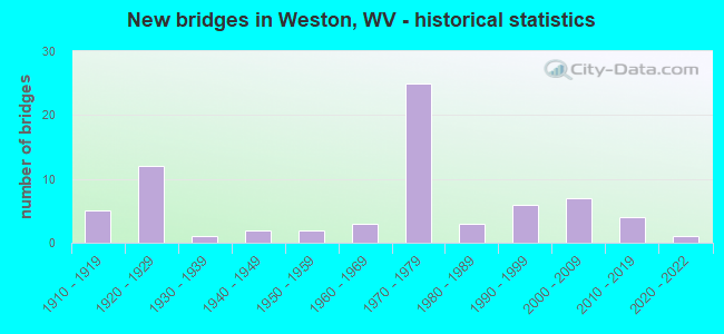
- New bridges - historical statistics
- 51910-1919
- 121920-1929
- 11930-1939
- 21940-1949
- 21950-1959
- 31960-1969
- 251970-1979
- 31980-1989
- 61990-1999
- 72000-2009
- 42010-2019
- 12020-2022
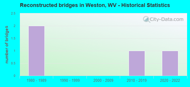
- Reconstructed bridges - Historical Statistics
- 21980-1989
- 01990-1999
- 02000-2009
- 12010-2019
- 12020-2022
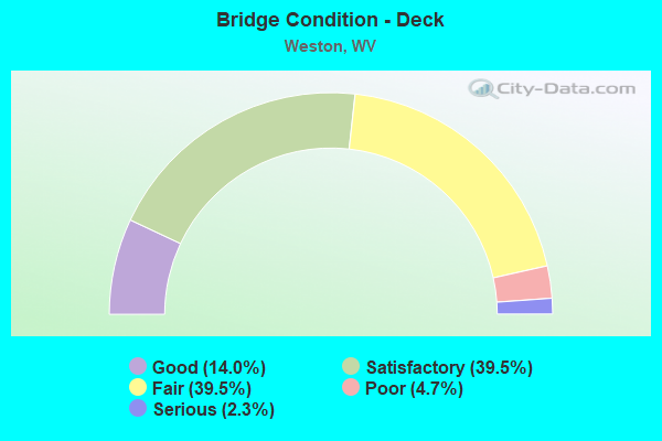
- Bridge Condition - Deck
- 14.0%Good
- 39.5%Satisfactory
- 39.5%Fair
- 4.7%Poor
- 2.3%Serious
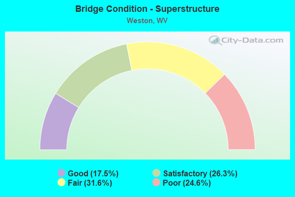
- Bridge Condition - Superstructure
- 17.5%Good
- 26.3%Satisfactory
- 31.6%Fair
- 24.6%Poor
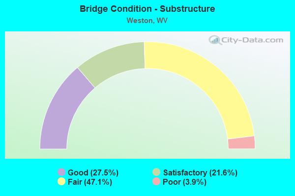
- Bridge Condition - Substructure
- 27.5%Good
- 21.6%Satisfactory
- 47.1%Fair
- 3.9%Poor
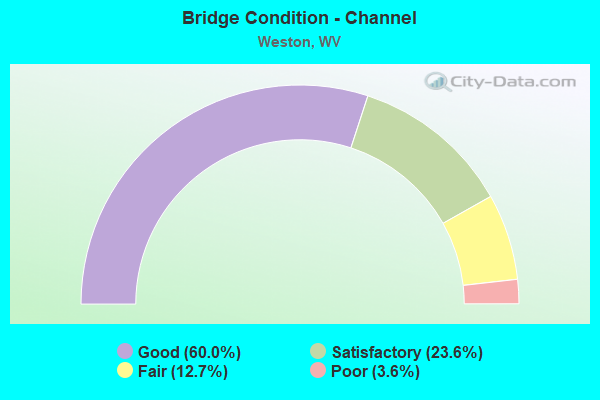
- Bridge Condition - Channel
- 60.0%Good
- 23.6%Satisfactory
- 12.7%Fair
- 3.6%Poor
Find on map >> Show street view
Structure Number: 21A185, Location: 0.58 MI W OF CO RT 1 (Lat: 39.078519, Lng: -80.477381), Route carried "on" structure: County highway 107, Year Built: 2001, Status: Open, Structure Length: 1.51m (4.95ft), Average Daily Traffic: 997 (year 2015), Truck Traffic: 5%, Average Future Daily Traffic: 1,136 (year 2035), Design Load: HS 25 or greater, Features Intersected: GEELICK RUN, Facility Carried by Structure: COUNTY ROUTE 1/7
Minimum Vertical Clearance: 30+ m (98+ ft), Kilometerpoint: 0.933, Lanes on structure: 2, Owner: State Highway Agency, Approaching Roadway Width: 6.7m (22.0ft), Skew: 3 degrees, Material/Design: Prestressed concrete, Design/Construction: Box Beam or Girders - Multiple, Number Of Spans In Main Unit: 1, Length of Maximum Span: 14.6m (47.9ft), Curb-To-Curb Width: 8.7m (28.5ft), Out-to-Out Width: 9.2m (30.2ft)
Condition: Deck: Satisfactory, Superstructure: Satisfactory, Substructure: Good, Channel: Good, Operating Rating: 89.8 metric tons, Method Used To Determine Operating Rating: Load and Resistance Factor (LRFR), Inventory Rating: 73.5 metric tons, Method Used To Determine Inventory Rating: Load and Resistance Factor (LRFR), Structural Evaluation: Equal to present minimum criteria, Deck Geometry: Somewhat better than minimum adequacy, Waterway Adequacy: Equal to present desirable criteria, Approach Roadway Alignment: Equal to present minimum criteria, Designated Inspection Frequency: Every 48 months, Inspection Date: August 2019, Deck Structure Type: Concrete Cast-file-Place
Find on map >> Show street view
Structure Number: 21A186, Location: 0.02 MI S OF US 33 (Lat: 39.049639, Lng: -80.487711), Route carried "on" structure: Other road 93200, Year Built: 2001, Status: Open, Structure Length: 0.84m (2.76ft), Average Daily Traffic: 44 (year 2015), Average Future Daily Traffic: 50 (year 2035), Design Load: HS 25 or greater, Features Intersected: POLK CREEK, Facility Carried by Structure: HARP RT 932
Minimum Vertical Clearance: 30+ m (98+ ft), Kilometerpoint: 0.032, Lanes on structure: 1, Owner: State Highway Agency, Approaching Roadway Width: 3.7m (12.1ft), Material/Design: Prestressed concrete, Design/Construction: Slab, Number Of Spans In Main Unit: 1, Length of Maximum Span: 8.0m (26.2ft), Curb or Sidewalk Widths: Left: 0.2m (0.7ft), Right: 0.2m (0.7ft), Curb-To-Curb Width: 4.6m (15.1ft), Out-to-Out Width: 4.9m (16.1ft)
Condition: Deck: Satisfactory, Superstructure: Satisfactory, Substructure: Good, Channel: Good, Operating Rating: 45.4 metric tons, Method Used To Determine Operating Rating: Load and Resistance Factor (LRFR), Inventory Rating: 35.4 metric tons, Method Used To Determine Inventory Rating: Load and Resistance Factor (LRFR), Structural Evaluation: Equal to present minimum criteria, Deck Geometry: Better than present minimum criteria, Waterway Adequacy: Equal to present minimum criteria, Approach Roadway Alignment: Equal to present desirable criteria, Designated Inspection Frequency: Every 48 months, Inspection Date: December 2019, Deck Structure Type: Other
Find on map >> Show street view
Structure Number: 21A188, Location: 0.01 MI S CO 22 (Lat: 39.025231, Lng: -80.477569), Route carried "on" structure: County highway 2400, Year Built: 2002, Status: Open, Structure Length: 1.59m (5.22ft), Average Daily Traffic: 592 (year 2015), Truck Traffic: 5%, Average Future Daily Traffic: 674 (year 2035), Design Load: HS 25 or greater, Features Intersected: MURPHY CREEK, Facility Carried by Structure: COUNTY ROUTE 24
Minimum Vertical Clearance: 30+ m (98+ ft), Kilometerpoint: 7.435, Lanes on structure: 2, Owner: State Highway Agency, Approaching Roadway Width: 5.5m (18.0ft), Material/Design: Prestressed concrete, Design/Construction: Box Beam or Girders - Multiple, Number Of Spans In Main Unit: 1, Length of Maximum Span: 14.6m (47.9ft), Curb-To-Curb Width: 7.9m (25.9ft), Out-to-Out Width: 8.4m (27.6ft)
Condition: Deck: Satisfactory, Superstructure: Satisfactory, Substructure: Good, Channel: Good, Operating Rating: 54.4 metric tons, Method Used To Determine Operating Rating: Load and Resistance Factor (LRFR), Inventory Rating: 41.7 metric tons, Method Used To Determine Inventory Rating: Load and Resistance Factor (LRFR), Structural Evaluation: Equal to present minimum criteria, Deck Geometry: Somewhat better than minimum adequacy, Waterway Adequacy: Equal to present desirable criteria, Approach Roadway Alignment: Better than present minimum criteria, Designated Inspection Frequency: Every 48 months, Inspection Date: September 2020, Deck Structure Type: Other, Wearing Surface/Protective System: Wearing Surface: Bituminous, Deck Protection: Epoxy Coated Reinforcing
Find on map >> Show street view
Structure Number: 21A189, Location: .05 MI N CO 14 SLS (Lat: 39.041069, Lng: -80.439011), Route carried "on" structure: County highway 1404, Year Built: 1997, Status: Open, Structure Length: 0.74m (2.43ft), Average Daily Traffic: 10 (year 2015), Average Future Daily Traffic: 12 (year 2035), Design Load: HS 25 or greater, Features Intersected: SMITH RUN, Facility Carried by Structure: COUNTY ROUTE 14/4
Minimum Vertical Clearance: 30+ m (98+ ft), Kilometerpoint: 0.080, Lanes on structure: 1, Owner: State Highway Agency, Approaching Roadway Width: 4.6m (15.1ft), Skew: 1 degrees, Material/Design: Steel, Design/Construction: Stringer/Multi-beam, Number Of Spans In Main Unit: 1, Length of Maximum Span: 7.1m (23.3ft), Curb or Sidewalk Widths: Left: 0.2m (0.7ft), Right: 0.2m (0.7ft), Curb-To-Curb Width: 4.8m (15.7ft), Out-to-Out Width: 6.0m (19.7ft)
Condition: Deck: Satisfactory, Superstructure: Fair, Substructure: Fair, Channel: Satisfactory, Operating Rating: 55.3 metric tons, Method Used To Determine Operating Rating: Load Factor (LF), Inventory Rating: 33.6 metric tons, Method Used To Determine Inventory Rating: Load Factor (LF), Structural Evaluation: Somewhat better than minimum adequacy, Deck Geometry: Equal to present desirable criteria, Waterway Adequacy: Equal to present desirable criteria, Approach Roadway Alignment: Equal to present minimum criteria, Designated Inspection Frequency: Every 24 months, Inspection Date: July 2020, Deck Structure Type: Wood or Timber
Find on map >> Show street view
Structure Number: 21A19, Location: 0.01 MI E OF US RT 33 F (Lat: 39.036561, Lng: -80.459350), Route carried "on" structure: County highway 3325, Year Built: 2002, Status: Open, Structure Length: 1.88m (6.17ft), Average Daily Traffic: 1,000 (year 2018), Truck Traffic: 9%, Average Future Daily Traffic: 1,150 (year 2038), Design Load: HS 25 or greater, Features Intersected: STONECOAL CREEK, Facility Carried by Structure: COUNTY ROUTE 33/25
Minimum Vertical Clearance: 30+ m (98+ ft), Kilometerpoint: 0.016, Lanes on structure: 3, Owner: State Highway Agency, Approaching Roadway Width: 7.6m (24.9ft), Material/Design: Prestressed concrete, Design/Construction: Box Beam or Girders - Multiple, Number Of Spans In Main Unit: 1, Length of Maximum Span: 17.8m (58.4ft), Curb or Sidewalk Widths: Left: 0.9m (3.0ft), Right: 0.0m, Curb-To-Curb Width: 10.7m (35.1ft), Out-to-Out Width: 12.1m (39.7ft)
Condition: Deck: Satisfactory, Superstructure: Satisfactory, Substructure: Fair, Channel: Satisfactory, Operating Rating: 57.1 metric tons, Method Used To Determine Operating Rating: Load and Resistance Factor (LRFR), Inventory Rating: 44.4 metric tons, Method Used To Determine Inventory Rating: Load and Resistance Factor (LRFR), Structural Evaluation: Somewhat better than minimum adequacy, Deck Geometry: High priority of replacement, Waterway Adequacy: Equal to present desirable criteria, Approach Roadway Alignment: Equal to present desirable criteria, Designated Inspection Frequency: Every 24 months, Inspection Date: June 2021, Deck Structure Type: Other, Wearing Surface/Protective System: Wearing Surface: Bituminous, Membrane: Other, Deck Protection: Epoxy Coated Reinforcing
Find on map >> Show street view
Structure Number: 21A191, Location: 0.01 MI W CO 12 (Lat: 39.095611, Lng: -80.466181), Route carried "on" structure: County highway 1000, Year Built: 2003, Status: Open, Structure Length: 9.12m (29.92ft), Average Daily Traffic: 1,500 (year 2015), Truck Traffic: 5%, Average Future Daily Traffic: 2,010 (year 2035), Design Load: HS 25 or greater, Features Intersected: WEST FORK RIVER, Facility Carried by Structure: COUNTY ROUTE 10
Minimum Vertical Clearance: 30+ m (98+ ft), Kilometerpoint: 28.083, Lanes on structure: 2, Owner: State Highway Agency, Approaching Roadway Width: 8.5m (27.9ft), Skew: 1 degrees, Material/Design: Steel continuous, Design/Construction: Stringer/Multi-beam, Number Of Spans In Main Unit: 1, Number Of Approach Spans: 2, Length of Maximum Span: 36.6m (120.1ft), Curb or Sidewalk Widths: Left: 1.6m (5.2ft), Right: 0.0m, Curb-To-Curb Width: 8.5m (27.9ft), Out-to-Out Width: 10.8m (35.4ft)
Condition: Deck: Satisfactory, Superstructure: Good, Substructure: Satisfactory, Channel: Good, Operating Rating: 35.4 metric tons, Method Used To Determine Operating Rating: Load and Resistance Factor (LRFR), Inventory Rating: 27.2 metric tons, Method Used To Determine Inventory Rating: Load and Resistance Factor (LRFR), Structural Evaluation: Equal to present minimum criteria, Deck Geometry: Somewhat better than minimum adequacy, Waterway Adequacy: Equal to present desirable criteria, Approach Roadway Alignment: Equal to present desirable criteria, Designated Inspection Frequency: Every 24 months, Inspection Date: July 2020, Deck Structure Type: Concrete Cast-file-Place, Wearing Surface/Protective System: Deck Protection: Epoxy Coated Reinforcing
Find on map >> Show street view
Structure Number: 21A195, Location: 0.41 MI S US 33 (Lat: 39.010269, Lng: -80.410339), Route carried "on" structure: County highway 11918, Year Built: 2004, Status: Open, Structure Length: 0.84m (2.76ft), Average Daily Traffic: 221 (year 2015), Truck Traffic: 5%, Average Future Daily Traffic: 252 (year 2035), Design Load: HS 25 or greater, Features Intersected: HERDMAN RUN, Facility Carried by Structure: CO 119/18
Minimum Vertical Clearance: 30+ m (98+ ft), Kilometerpoint: 3.058, Lanes on structure: 2, Owner: State Highway Agency, Approaching Roadway Width: 6.1m (20.0ft), Skew: 4 degrees, Material/Design: Concrete, Design/Construction: Culvert, Number Of Spans In Main Unit: 2, Length of Maximum Span: 3.9m (12.8ft), Curb-To-Curb Width: 8.6m (28.2ft), Out-to-Out Width: 9.1m (29.9ft)
Condition: Channel: Good, Culverts: Satisfactory, Operating Rating: 88.9 metric tons, Method Used To Determine Operating Rating: Field evaluation and documented engineering judgment, Inventory Rating: 40.8 metric tons, Method Used To Determine Inventory Rating: Field evaluation and documented engineering judgment, Structural Evaluation: Equal to present minimum criteria, Deck Geometry: Equal to present minimum criteria, Waterway Adequacy: Superior to present desirable criteria, Approach Roadway Alignment: Superior to present desirable criteria, Designated Inspection Frequency: Every 48 months, Inspection Date: September 2020, Deck Structure Type: Other, Wearing Surface/Protective System: Wearing Surface: Bituminous
Find on map >> Show street view
Structure Number: 21A199, Location: 0.60 MI N OF US RT 33 F (Lat: 39.045339, Lng: -80.464400), Route carried "on" structure: County highway 100, Year Built: 2010, Status: Open, Structure Length: 1.91m (6.27ft), Average Daily Traffic: 2,200 (year 2018), Truck Traffic: 8%, Average Future Daily Traffic: 2,530 (year 2038), Design Load: HL 93, Features Intersected: POLK CREEK, Facility Carried by Structure: COUNTY ROUTE 1 SLS
Minimum Vertical Clearance: 30+ m (98+ ft), Kilometerpoint: 0.966, Lanes on structure: 2, Owner: State Highway Agency, Approaching Roadway Width: 7.3m (24.0ft), Material/Design: Prestressed concrete, Design/Construction: Box Beam or Girders - Multiple, Number Of Spans In Main Unit: 1, Length of Maximum Span: 17.8m (58.4ft), Curb or Sidewalk Widths: Left: 1.2m (3.9ft), Right: 0.0m, Curb-To-Curb Width: 8.0m (26.2ft), Out-to-Out Width: 9.3m (30.5ft)
Condition: Deck: Good, Superstructure: Good, Substructure: Good, Channel: Good, Operating Rating: 54.4 metric tons, Method Used To Determine Operating Rating: Load and Resistance Factor (LRFR), Inventory Rating: 41.7 metric tons, Method Used To Determine Inventory Rating: Load and Resistance Factor (LRFR), Structural Evaluation: Better than present minimum criteria, Deck Geometry: High priority of corrective action, Waterway Adequacy: Superior to present desirable criteria, Approach Roadway Alignment: Equal to present desirable criteria, Designated Inspection Frequency: Every 48 months, Inspection Date: July 2021, Deck Structure Type: Other, Wearing Surface/Protective System: Wearing Surface: Bituminous
Find on map >> Show street view
Structure Number: 21A207, Location: 0.16 MI W OF CO 14 (Lat: 39.038881, Lng: -80.448481), Route carried "on" structure: County highway 3325, Year Built: 2014, Status: Open, Structure Length: 1.22m (4.00ft), Average Daily Traffic: 100 (year 2015), Average Future Daily Traffic: 118 (year 2035), Design Load: HL 93, Features Intersected: SMITH RUN, Facility Carried by Structure: COUNTY ROAD 33/25
Minimum Vertical Clearance: 30+ m (98+ ft), Kilometerpoint: 1.287, Lanes on structure: 2, Owner: State Highway Agency, Approaching Roadway Width: 7.3m (24.0ft), Material/Design: Prestressed concrete, Design/Construction: Box Beam or Girders - Multiple, Number Of Spans In Main Unit: 1, Length of Maximum Span: 12.2m (40.0ft), Curb-To-Curb Width: 7.3m (24.0ft), Out-to-Out Width: 7.4m (24.3ft)
Condition: Superstructure: Good, Substructure: Good, Channel: Good, Operating Rating: 56.2 metric tons, Method Used To Determine Operating Rating: Load and Resistance Factor (LRFR), Inventory Rating: 43.5 metric tons, Method Used To Determine Inventory Rating: Load and Resistance Factor (LRFR), Structural Evaluation: Better than present minimum criteria, Deck Geometry: Equal to present minimum criteria, Waterway Adequacy: Equal to present desirable criteria, Approach Roadway Alignment: Equal to present desirable criteria, Designated Inspection Frequency: Every 48 months, Inspection Date: July 2018, Wearing Surface/Protective System: Wearing Surface: Bituminous, Membrane: Other, Deck Protection: Epoxy Coated Reinforcing
Find on map >> Show street view
Structure Number: 21A209, Location: 0.34 MI S OF CO 19/3 (Lat: 39.015250, Lng: -80.484481), Route carried "on" structure: US 19, Year Built: 1951, Year Reconstructed: 2016, Status: Open, Structure Length: 7.53m (24.70ft), Average Daily Traffic: 2,325 (year 2015), Truck Traffic: 14%, Average Future Daily Traffic: 3,060 (year 2035), Design Load: HL 93, Features Intersected: WEST FORK RIVER
Minimum Vertical Clearance: 30+ m (98+ ft), Kilometerpoint: 35.454, Lanes on structure: 2, Owner: State Highway Agency, Approaching Roadway Width: 10.1m (33.1ft), Skew: 2 degrees, Material/Design: Steel continuous, Design/Construction: Stringer/Multi-beam, Number Of Spans In Main Unit: 1, Number Of Approach Spans: 2, Length of Maximum Span: 0.0m, Curb-To-Curb Width: 9.9m (32.5ft), Out-to-Out Width: 10.6m (34.8ft)
Condition: Deck: Good, Superstructure: Good, Substructure: Satisfactory, Channel: Satisfactory, Operating Rating: 57.1 metric tons, Method Used To Determine Operating Rating: Load and Resistance Factor (LRFR), Inventory Rating: 44.4 metric tons, Method Used To Determine Inventory Rating: Load and Resistance Factor (LRFR), Structural Evaluation: Equal to present minimum criteria, Deck Geometry: Meets minimum limits, Approach Roadway Alignment: Superior to present desirable criteria, Designated Inspection Frequency: Every 48 months, Inspection Date: September 2019, Deck Structure Type: Concrete Cast-file-Place, Wearing Surface/Protective System: Wearing Surface: Integral Concrete, Membrane: Epoxy, Deck Protection: Epoxy Coated Reinforcing
Find on map >> Show street view
Structure Number: 21A212, Location: 0.03 MI N OF CO RT 1/5 (Lat: 39.092850, Lng: -80.478100), Route carried "on" structure: County highway 1, Year Built: 2018, Status: Open, Structure Length: 2.50m (8.20ft), Average Daily Traffic: 1,700 (year 2018), Truck Traffic: 5%, Average Future Daily Traffic: 2,278 (year 2038), Design Load: Greater than HL93, Features Intersected: FREEMANS CREEK
Minimum Vertical Clearance: 30+ m (98+ ft), Kilometerpoint: 7.500, Lanes on structure: 2, Owner: State Highway Agency, Approaching Roadway Width: 7.9m (25.9ft), Material/Design: Steel, Design/Construction: Stringer/Multi-beam, Number Of Spans In Main Unit: 1, Length of Maximum Span: 24.4m (80.1ft), Curb-To-Curb Width: 8.0m (26.2ft), Out-to-Out Width: 8.7m (28.5ft)
Condition: Deck: Good, Superstructure: Good, Substructure: Good, Channel: Good, Operating Rating: 65.3 metric tons, Method Used To Determine Operating Rating: Load and Resistance Factor (LRFR), Inventory Rating: 50.8 metric tons, Method Used To Determine Inventory Rating: Load and Resistance Factor (LRFR), Structural Evaluation: Better than present minimum criteria, Deck Geometry: Meets minimum limits, Waterway Adequacy: Equal to present desirable criteria, Approach Roadway Alignment: Equal to present desirable criteria, Designated Inspection Frequency: Every 48 months, Inspection Date: October 2020, Deck Structure Type: Concrete Cast-file-Place, Wearing Surface/Protective System: Deck Protection: Epoxy Coated Reinforcing
Find on map >> Show street view
Structure Number: 21A213, Location: 0..4 MI E OF CO 1/11 (Lat: 39.067950, Lng: -80.494189), Route carried "on" structure: County highway 107, Year Built: 2018, Status: Open, Structure Length: 1.48m (4.86ft), Average Daily Traffic: 500 (year 2018), Truck Traffic: 5%, Average Future Daily Traffic: 670 (year 2038), Design Load: HL 93, Features Intersected: DUTCH HOLLOW CREEK, Facility Carried by Structure: COUNTY ROUTE 1/7
Minimum Vertical Clearance: 30+ m (98+ ft), Kilometerpoint: 2.977, Lanes on structure: 2, Owner: State Highway Agency, Approaching Roadway Width: 8.8m (28.9ft), Skew: 3 degrees, Material/Design: Prestressed concrete, Design/Construction: Box Beam or Girders - Multiple, Number Of Spans In Main Unit: 1, Length of Maximum Span: 13.4m (44.0ft), Curb-To-Curb Width: 8.3m (27.2ft), Out-to-Out Width: 8.4m (27.6ft)
Condition: Deck: Good, Superstructure: Good, Substructure: Good, Channel: Good, Operating Rating: 59.0 metric tons, Method Used To Determine Operating Rating: Load and Resistance Factor (LRFR), Inventory Rating: 45.4 metric tons, Method Used To Determine Inventory Rating: Load and Resistance Factor (LRFR), Structural Evaluation: Better than present minimum criteria, Deck Geometry: Somewhat better than minimum adequacy, Waterway Adequacy: Better than present minimum criteria, Approach Roadway Alignment: Better than present minimum criteria, Designated Inspection Frequency: Every 48 months, Inspection Date: November 2020, Deck Structure Type: Concrete Precast Panels, Wearing Surface/Protective System: Wearing Surface: Bituminous, Membrane: Other, Deck Protection: Epoxy Coated Reinforcing
Find on map >> Show street view
Structure Number: 21A215, Location: 0.09 MI W OF CO 14 (Lat: 39.036281, Lng: -80.448619), Route carried "on" structure: US 3300, Year Built: 2020, Status: Open, Structure Length: 2.29m (7.51ft), Average Daily Traffic: 17,025 (year 2015), Truck Traffic: 14%, Average Future Daily Traffic: 23,421 (year 2035), Design Load: HL 93, Features Intersected: Stonecoal Creek, Facility Carried by Structure: US 33
Minimum Vertical Clearance: 30+ m (98+ ft), Kilometerpoint: 29.515, Lanes on structure: 3, Base Highway Network: Yes, Owner: State Highway Agency, Approaching Roadway Width: 14.3m (46.9ft), Material/Design: Prestressed concrete, Design/Construction: Box Beam or Girders - Single/Spread, Number Of Spans In Main Unit: 1, Length of Maximum Span: 22.9m (75.1ft), Curb or Sidewalk Widths: Left: 1.5m (4.9ft), Right: 0.0m, Curb-To-Curb Width: 14.3m (46.9ft), Out-to-Out Width: 16.5m (54.1ft)
Condition: Deck: Good, Superstructure: Good, Substructure: Good, Channel: Good, Operating Rating: 37.2 metric tons, Method Used To Determine Operating Rating: Load and Resistance Factor (LRFR), Inventory Rating: 29.0 metric tons, Method Used To Determine Inventory Rating: Load and Resistance Factor (LRFR), Structural Evaluation: Better than present minimum criteria, Deck Geometry: Somewhat better than minimum adequacy, Waterway Adequacy: Better than present minimum criteria, Approach Roadway Alignment: Equal to present minimum criteria, Designated Inspection Frequency: Every 24 months, Inspection Date: August 2020, Deck Structure Type: Concrete Cast-file-Place, Wearing Surface/Protective System: Wearing Surface: Monolithic Concrete
Find on map >> Show street view
Structure Number: 21A218, Location: 0.01 MI W JCT US 33 (Lat: 39.026711, Lng: -80.430700), Route carried "on" structure: County highway 3322, Year Built: 1994, Year Reconstructed: 2020, Status: Open, Structure Length: 2.37m (7.78ft), Average Daily Traffic: 20 (year 2018), Truck Traffic: 9%, Average Future Daily Traffic: 23 (year 2038), Design Load: HL 93, Features Intersected: STONECOAL CREEK, Facility Carried by Structure: COUNTY 33/22 (SLS)
Minimum Vertical Clearance: 30+ m (98+ ft), Kilometerpoint: 0.016, Lanes on structure: 2, Owner: State Highway Agency, Approaching Roadway Width: 8.2m (26.9ft), Material/Design: Prestressed concrete, Design/Construction: Box Beam or Girders - Multiple, Number Of Spans In Main Unit: 1, Length of Maximum Span: 22.6m (74.1ft), Curb or Sidewalk Widths: Left: 0.1m (0.3ft), Right: 0.1m (0.3ft), Curb-To-Curb Width: 7.3m (24.0ft), Out-to-Out Width: 7.4m (24.3ft)
Condition: Deck: Good, Superstructure: Good, Substructure: Good, Channel: Good, Operating Rating: 48.1 metric tons, Method Used To Determine Operating Rating: Load and Resistance Factor (LRFR), Inventory Rating: 38.1 metric tons, Method Used To Determine Inventory Rating: Load and Resistance Factor (LRFR), Structural Evaluation: Better than present minimum criteria, Deck Geometry: Equal to present minimum criteria, Waterway Adequacy: Equal to present minimum criteria, Approach Roadway Alignment: Equal to present minimum criteria, Designated Inspection Frequency: Every 24 months, Inspection Date: June 2021, Deck Structure Type: Concrete Precast Panels, Wearing Surface/Protective System: Wearing Surface: Bituminous, Membrane: Other, Deck Protection: Epoxy Coated Reinforcing
Find on map >> Show street view
Structure Number: 21A905, Location: 0.02 MI W OF US 19 (Lat: 39.041489, Lng: -80.465250), Route carried "on" structure: City street N1670, Year Built: 1913, Status: Posted for load, Structure Length: 3.55m (11.65ft), Average Daily Traffic: 3,200 (year 2018), Truck Traffic: 5%, Average Future Daily Traffic: 4,096 (year 2038), Design Load: H 10, Features Intersected: WEST FORK RIVER, Facility Carried by Structure: WEST FOURTH STREET
Minimum Vertical Clearance: 30+ m (98+ ft), Kilometerpoint: 0.032, Lanes on structure: 2, Owner: City or Municipal Highway Agency, Approaching Roadway Width: 7.9m (25.9ft), Material/Design: Concrete, Design/Construction: Arch - Deck, Number Of Spans In Main Unit: 2, Length of Maximum Span: 16.2m (53.1ft), Curb or Sidewalk Widths: Left: 0.1m (0.3ft), Right: 1.3m (4.3ft), Curb-To-Curb Width: 7.5m (24.6ft), Out-to-Out Width: 8.8m (28.9ft)
Condition: Superstructure: Poor, Substructure: Poor, Channel: Satisfactory, Operating Rating: 28.1 metric tons, Method Used To Determine Operating Rating: Field evaluation and documented engineering judgment, Inventory Rating: 11.8 metric tons, Method Used To Determine Inventory Rating: Field evaluation and documented engineering judgment, Structural Evaluation: High priority of replacement, Deck Geometry: High priority of replacement, Waterway Adequacy: Superior to present desirable criteria, Approach Roadway Alignment: Equal to present desirable criteria, Bridge Posting: Required (Relationship of Operating Rating to Maximum Legal Load: 10.0 - 19.9% below), Length Of Structure Improvement: 3.66m (12.01ft), Designated Inspection Frequency: Every 24 months, Inspection Date: August 2021, Bridge Improvement Cost: $1,700,000, Roadway Improvement Cost: $500,000, Total Project Cost: $3,500,000 ( Estimate for 2021)
Find on map >> Show street view
Structure Number: 21A906, Location: 0.01 MI N OF US33 (Lat: 39.046139, Lng: -80.475431), Route carried "on" structure: City street N1670, Year Built: 1925, Status: Open, Structure Length: 1.57m (5.15ft), Average Daily Traffic: 775 (year 2018), Truck Traffic: 5%, Average Future Daily Traffic: 992 (year 2038), Features Intersected: POLK CREEK, Facility Carried by Structure: HOWELL STREET
Minimum Vertical Clearance: 30+ m (98+ ft), Kilometerpoint: 0.064, Lanes on structure: 2, Owner: City or Municipal Highway Agency, Approaching Roadway Width: 5.5m (18.0ft), Material/Design: Concrete, Design/Construction: Arch - Deck, Number Of Spans In Main Unit: 1, Length of Maximum Span: 13.0m (42.7ft), Curb or Sidewalk Widths: Left: 0.0m, Right: 1.5m (4.9ft), Curb-To-Curb Width: 5.4m (17.7ft), Out-to-Out Width: 7.3m (24.0ft)
Condition: Superstructure: Fair, Channel: Good, Operating Rating: 41.7 metric tons, Method Used To Determine Operating Rating: Field evaluation and documented engineering judgment, Inventory Rating: 17.2 metric tons, Method Used To Determine Inventory Rating: Field evaluation and documented engineering judgment, Structural Evaluation: Meets minimum limits, Deck Geometry: High priority of replacement, Waterway Adequacy: Better than present minimum criteria, Approach Roadway Alignment: Better than present minimum criteria, Length Of Structure Improvement: 2.29m (7.51ft), Designated Inspection Frequency: Every 24 months, Inspection Date: August 2021, Bridge Improvement Cost: $350,000, Roadway Improvement Cost: $150,000, Total Project Cost: $650,000 ( Estimate for 2021)
Find on map >> Show street view
Structure Number: 21A907, Location: 0.02 MI N OF US 33 (Lat: 39.041581, Lng: -80.470831), Route carried "on" structure: City street N1670, Year Built: 1920, Status: Open, Structure Length: 0.99m (3.25ft), Average Daily Traffic: 1,800 (year 2018), Truck Traffic: 8%, Average Future Daily Traffic: 2,300 (year 2038), Features Intersected: POLK CREEK, Facility Carried by Structure: DEPOT STREET
Minimum Vertical Clearance: 30+ m (98+ ft), Kilometerpoint: 0.080, Lanes on structure: 2, Owner: City or Municipal Highway Agency, Approaching Roadway Width: 8.5m (27.9ft), Material/Design: Concrete, Design/Construction: Arch - Deck, Number Of Spans In Main Unit: 1, Length of Maximum Span: 9.1m (29.9ft), Curb or Sidewalk Widths: Left: 2.3m (7.5ft), Right: 0.0m, Curb-To-Curb Width: 7.7m (25.3ft), Out-to-Out Width: 7.9m (25.9ft)
Condition: Superstructure: Satisfactory, Channel: Good, Operating Rating: 47.2 metric tons, Method Used To Determine Operating Rating: Field evaluation and documented engineering judgment, Inventory Rating: 21.8 metric tons, Method Used To Determine Inventory Rating: Field evaluation and documented engineering judgment, Structural Evaluation: Somewhat better than minimum adequacy, Deck Geometry: Meets minimum limits, Waterway Adequacy: Better than present minimum criteria, Approach Roadway Alignment: Equal to present desirable criteria, Designated Inspection Frequency: Every 24 months, Inspection Date: August 2021
Find on map >> Show street view
Structure Number: 21A908, Location: 0.25 MI N OF US 119 (Lat: 39.041939, Lng: -80.461831), Route carried "on" structure: City street N1670, Year Built: 1977, Status: Open, Structure Length: 1.78m (5.84ft), Average Daily Traffic: 750 (year 2018), Truck Traffic: 5%, Average Future Daily Traffic: 915 (year 2038), Design Load: HS 20, Features Intersected: STONECOAL CREEK, Facility Carried by Structure: CENTER AVENUE
Minimum Vertical Clearance: 30+ m (98+ ft), Kilometerpoint: 0.097, Lanes on structure: 2, Owner: City or Municipal Highway Agency, Approaching Roadway Width: 7.3m (24.0ft), Skew: 1 degrees, Material/Design: Steel, Design/Construction: Stringer/Multi-beam, Number Of Spans In Main Unit: 1, Length of Maximum Span: 16.8m (55.1ft), Curb or Sidewalk Widths: Left: 0.9m (3.0ft), Right: 0.9m (3.0ft), Curb-To-Curb Width: 7.3m (24.0ft), Out-to-Out Width: 9.8m (32.2ft)
Condition: Deck: Satisfactory, Superstructure: Satisfactory, Substructure: Satisfactory, Channel: Good, Operating Rating: 88.0 metric tons, Method Used To Determine Operating Rating: Load Factor (LF), Inventory Rating: 52.6 metric tons, Method Used To Determine Inventory Rating: Load Factor (LF), Structural Evaluation: Equal to present minimum criteria, Deck Geometry: Meets minimum limits, Waterway Adequacy: Equal to present minimum criteria, Approach Roadway Alignment: Equal to present desirable criteria, Length Of Structure Improvement: 0.91m (2.99ft), Designated Inspection Frequency: Every 24 months, Inspection Date: August 2021, Bridge Improvement Cost: $19,000, Roadway Improvement Cost: $15,000, Total Project Cost: $40,000 ( Estimate for 2021), Deck Structure Type: Concrete Cast-file-Place, Wearing Surface/Protective System: Deck Protection: Epoxy Coated Reinforcing
Find on map >> Show street view
Structure Number: 21A909, Location: 0.23 MI N OF US 119 (Lat: 39.041081, Lng: -80.461061), Route carried "on" structure: City street N1670, Year Built: 1977, Status: Open, Structure Length: 1.66m (5.45ft), Average Daily Traffic: 750 (year 2018), Truck Traffic: 5%, Average Future Daily Traffic: 800 (year 2038), Design Load: HS 20, Features Intersected: STONECOAL CREEK, Facility Carried by Structure: COURT AVENUE
Minimum Vertical Clearance: 30+ m (98+ ft), Kilometerpoint: 0.113, Lanes on structure: 2, Owner: City or Municipal Highway Agency, Approaching Roadway Width: 6.1m (20.0ft), Skew: 1 degrees, Material/Design: Steel, Design/Construction: Stringer/Multi-beam, Number Of Spans In Main Unit: 1, Length of Maximum Span: 15.5m (50.9ft), Curb or Sidewalk Widths: Left: 0.9m (3.0ft), Right: 0.9m (3.0ft), Curb-To-Curb Width: 7.3m (24.0ft), Out-to-Out Width: 9.8m (32.2ft)
Condition: Deck: Satisfactory, Superstructure: Satisfactory, Substructure: Satisfactory, Channel: Good, Operating Rating: 86.2 metric tons, Method Used To Determine Operating Rating: Load Factor (LF), Inventory Rating: 51.7 metric tons, Method Used To Determine Inventory Rating: Load Factor (LF), Structural Evaluation: Equal to present minimum criteria, Deck Geometry: Meets minimum limits, Waterway Adequacy: Equal to present minimum criteria, Approach Roadway Alignment: Equal to present desirable criteria, Length Of Structure Improvement: 1.52m (4.99ft), Designated Inspection Frequency: Every 24 months, Inspection Date: August 2021, Bridge Improvement Cost: $28,000, Roadway Improvement Cost: $15,000, Total Project Cost: $51,000 ( Estimate for 2021), Deck Structure Type: Concrete Cast-file-Place, Wearing Surface/Protective System: Deck Protection: Epoxy Coated Reinforcing
Find on map >> Show street view
Structure Number: 21A91, Location: 0.06 MI W OF CO 1 SLS (Lat: 39.042219, Lng: -80.466189), Route carried "on" structure: City street N1670, Year Built: 1945, Status: Open, Structure Length: 1.47m (4.82ft), Average Daily Traffic: 500 (year 2018), Truck Traffic: 5%, Average Future Daily Traffic: 640 (year 2038), Design Load: H 10, Features Intersected: POLK CREEK, Facility Carried by Structure: WEST FOURTH STREET
Minimum Vertical Clearance: 30+ m (98+ ft), Kilometerpoint: 0.145, Lanes on structure: 2, Owner: City or Municipal Highway Agency, Approaching Roadway Width: 6.7m (22.0ft), Material/Design: Steel, Design/Construction: Stringer/Multi-beam, Number Of Spans In Main Unit: 2, Length of Maximum Span: 6.9m (22.6ft), Curb or Sidewalk Widths: Left: 1.2m (3.9ft), Right: 0.0m, Curb-To-Curb Width: 5.5m (18.0ft), Out-to-Out Width: 7.1m (23.3ft)
Condition: Deck: Serious, Superstructure: Poor, Substructure: Poor, Channel: Fair, Operating Rating: 31.7 metric tons, Method Used To Determine Operating Rating: Load Factor (LF), Inventory Rating: 14.5 metric tons, Method Used To Determine Inventory Rating: Load Factor (LF), Structural Evaluation: Meets minimum limits, Deck Geometry: High priority of replacement, Waterway Adequacy: Equal to present desirable criteria, Approach Roadway Alignment: Equal to present desirable criteria, Length Of Structure Improvement: 2.13m (6.99ft), Designated Inspection Frequency: Every 24 months, Inspection Date: August 2021, Bridge Improvement Cost: $265,000, Roadway Improvement Cost: $200,000, Total Project Cost: $576,000 ( Estimate for 2019), Deck Structure Type: Concrete Cast-file-Place, Wearing Surface/Protective System: Wearing Surface: Bituminous
Find on map >> Show street view
Structure Number: 2140003P, Location: 1.0 MI. FROM I-79 (SWJ) (Lat: 39.005000, Lng: -80.476667), Route carried "on" structure: Spur County highway 3, Year Built: 1983, Year Reconstructed: 1992, Status: Open, Structure Length: 5.61m (18.41ft), Average Daily Traffic: 30 (year 2016), Truck Traffic: 3%, Average Future Daily Traffic: 100 (year 2036), Design Load: HS 20, Features Intersected: WEST FORK RIVER, Facility Carried by Structure: SWJ DAM ACCESS RD.
Minimum Vertical Clearance: 30+ m (98+ ft), Kilometerpoint: 0.000, Lanes on structure: 2, Owner: Corps of Engineers (Civil), Approaching Roadway Width: 9.8m (32.2ft), Skew: 3 degrees, Material/Design: Steel, Design/Construction: Stringer/Multi-beam, Number Of Spans In Main Unit: 1, Length of Maximum Span: 46.2m (151.6ft), Curb or Sidewalk Widths: Left: 0.0m, Right: 1.1m (3.6ft), Curb-To-Curb Width: 7.3m (24.0ft), Out-to-Out Width: 9.6m (31.5ft)
Condition: Deck: Satisfactory, Superstructure: Satisfactory, Substructure: Fair, Channel: Fair, Operating Rating: 41.8 metric tons, Method Used To Determine Operating Rating: Load and Resistance Factor Rating (LRFR) rating reported by rating factor(RF) method using HL-93 loadings, Inventory Rating: 32.4 metric tons, Method Used To Determine Inventory Rating: Load and Resistance Factor Rating (LRFR) rating reported by rating factor(RF) method using HL-93 loadings, Structural Evaluation: Somewhat better than minimum adequacy, Deck Geometry: Equal to present minimum criteria, Waterway Adequacy: Equal to present desirable criteria, Approach Roadway Alignment: Equal to present minimum criteria, Length Of Structure Improvement: 4.63m (15.19ft), Designated Inspection Frequency: Every 24 months, Inspection Date: June 2020, Bridge Improvement Cost: $86,000, Roadway Improvement Cost: $14,000, Total Project Cost: $100,000 ( Estimate for 2020), Deck Structure Type: Concrete Cast-file-Place
Find on map >> Show street view
Structure Number: 21A117, Location: 2.87 MI S US 33 (Lat: 39.014569, Lng: -80.471769), Route carried "under" structure: County highway 1939, Year Built: 1972, Structure Length: 0. m, Average Daily Traffic: 200 (year 0009), Truck Traffic: 5%, Features Intersected: W Fk Rvr Co 19/39 & 38/3, Facility Carried by Structure: I-79 N
Minimum Vertical Clearance: 6.99m (22.93ft), Kilometerpoint: 1.046, Lanes on structure: 2, Lanes under structure: 2, Length of Maximum Span: 39.6m (129.9ft)
Find on map >> Show street view
Structure Number: 21A117, Location: 2.87 MI S US 33 (Lat: 39.014569, Lng: -80.471769), Route carried "under" structure: County highway 3803, Year Built: 1972, Structure Length: 0. m, Average Daily Traffic: 10 (year 0003), Features Intersected: W Fk Rvr Co 19/39 & 38/3, Facility Carried by Structure: I-79 N
Minimum Vertical Clearance: 6.81m (22.34ft), Kilometerpoint: 0.064, Lanes on structure: 2, Lanes under structure: 2, Length of Maximum Span: 39.6m (129.9ft)
Find on map >> Show street view
Structure Number: 21A118, Location: 2.87 M1 S OF US 33 (Lat: 39.014339, Lng: -80.471619), Route carried "under" structure: County highway 1939, Year Built: 1972, Structure Length: 0. m, Average Daily Traffic: 200 (year 0009), Truck Traffic: 5%, Features Intersected: W Fk Rvr Co 19/39 & 38/3, Facility Carried by Structure: I-79 S
Minimum Vertical Clearance: 6.99m (22.93ft), Kilometerpoint: 1.078, Lanes on structure: 3, Lanes under structure: 2, Length of Maximum Span: 39.6m (129.9ft)
Find on map >> Show street view
Structure Number: 21A118, Location: 2.87 M1 S OF US 33 (Lat: 39.014339, Lng: -80.471619), Route carried "under" structure: County highway 3803, Year Built: 1972, Structure Length: 0. m, Average Daily Traffic: 10 (year 0009), Features Intersected: W Fk Rvr Co 19/39 & 38/3, Facility Carried by Structure: I-79 S
Minimum Vertical Clearance: 6.81m (22.34ft), Kilometerpoint: 0.692, Lanes on structure: 3, Lanes under structure: 2, Length of Maximum Span: 39.6m (129.9ft)
Find on map >> Show street view
Structure Number: 21A124, Location: 2.81 MI N OF CO 19/39 (Lat: 39.021700, Lng: -80.427750), Route carried "under" structure: US 3300, Year Built: 1972, Structure Length: 0. m, Average Daily Traffic: 23,500 (year 0011), Truck Traffic: 27%, Features Intersected: US 33, Facility Carried by Structure: INTERSTATE 79
Minimum Vertical Clearance: 6.88m (22.57ft), Kilometerpoint: 32.139, Lanes on structure: 2, Lanes under structure: 4, Length of Maximum Span: 30.5m (100.1ft)
Find on map >> Show street view
Structure Number: 21A124, Location: 2.81 MI N OF CO 19/39 (Lat: 39.021700, Lng: -80.427750), Route carried "under" structure: Ramp US 3300, Year Built: 1972, Structure Length: 0. m, Average Daily Traffic: 5,300 (year 0011), Truck Traffic: 7%, Features Intersected: US 33, Facility Carried by Structure: INTERSTATE 79
Minimum Vertical Clearance: 5.05m (16.57ft), Kilometerpoint: 32.139, Lanes on structure: 2, Lanes under structure: 1, Length of Maximum Span: 30.5m (100.1ft)
Find on map >> Show street view
Structure Number: 21A124, Location: 2.81 MI N OF CO 19/39 (Lat: 39.021700, Lng: -80.427750), Route carried "under" structure: Ramp US 3300, Year Built: 1972, Structure Length: 0. m, Average Daily Traffic: 2,200 (year 0011), Truck Traffic: 7%, Features Intersected: US 33, Facility Carried by Structure: INTERSTATE 79
Minimum Vertical Clearance: 7.29m (23.92ft), Kilometerpoint: 32.139, Lanes on structure: 2, Lanes under structure: 1, Length of Maximum Span: 30.5m (100.1ft)
Find on map >> Show street view
Structure Number: 21A125, Location: 2.81 MI N OF CO 19/39 (Lat: 39.021719, Lng: -80.427689), Route carried "under" structure: Ramp US 3300, Year Built: 1972, Structure Length: 0. m, Average Daily Traffic: 2,200 (year 0011), Truck Traffic: 7%, Features Intersected: US 33, Facility Carried by Structure: INTERSTATE 79
Minimum Vertical Clearance: 7.29m (23.92ft), Kilometerpoint: 32.139, Lanes on structure: 3, Lanes under structure: 1, Length of Maximum Span: 30.5m (100.1ft)
Find on map >> Show street view
Structure Number: 21A125, Location: 2.81 MI N OF CO 19/39 (Lat: 39.021719, Lng: -80.427689), Route carried "under" structure: Ramp US 3300, Year Built: 1972, Structure Length: 0. m, Average Daily Traffic: 5,300 (year 0011), Truck Traffic: 7%, Features Intersected: US 33, Facility Carried by Structure: INTERSTATE 79
Minimum Vertical Clearance: 5.05m (16.57ft), Kilometerpoint: 32.139, Lanes on structure: 3, Lanes under structure: 1, Length of Maximum Span: 30.5m (100.1ft)
Find on map >> Show street view
Structure Number: 21A125, Location: 2.81 MI N OF CO 19/39 (Lat: 39.021719, Lng: -80.427689), Route carried "under" structure: US 3300, Year Built: 1972, Structure Length: 0. m, Average Daily Traffic: 23,500 (year 0009), Truck Traffic: 7%, Features Intersected: US 33, Facility Carried by Structure: INTERSTATE 79
Minimum Vertical Clearance: 6.45m (21.16ft), Kilometerpoint: 32.139, Lanes on structure: 3, Lanes under structure: 4, Length of Maximum Span: 30.5m (100.1ft)
Find on map >> Show street view
Structure Number: 21A126, Location: 2.74 MI N US 33 (Lat: 39.053931, Lng: -80.400431), Route carried "under" structure: County highway 1400, Year Built: 1971, Structure Length: 0. m, Average Daily Traffic: 400 (year 0009), Truck Traffic: 5%, Features Intersected: Co 14, Facility Carried by Structure: I-79 NBL
Minimum Vertical Clearance: 14.45m (47.41ft), Kilometerpoint: 5.069, Lanes on structure: 2, Lanes under structure: 2, Length of Maximum Span: 34.3m (112.5ft)
Find on map >> Show street view
Structure Number: 21A127, Location: 2.74 MI N US 33 (Lat: 39.054081, Lng: -80.400581), Route carried "under" structure: County highway 1400, Year Built: 1971, Structure Length: 0. m, Average Daily Traffic: 400 (year 0009), Truck Traffic: 20%, Features Intersected: Co 14, Facility Carried by Structure: I-79 SBL
Minimum Vertical Clearance: 12.67m (41.57ft), Kilometerpoint: 5.069, Lanes on structure: 2, Lanes under structure: 2, Length of Maximum Span: 31.6m (103.7ft)