Bridge Statistics for Weston, West Virginia (WV)
Condition, Traffic, Stress, Structural Evaluation, Project Costs
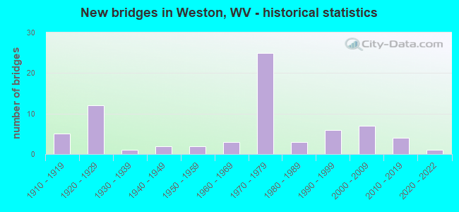
- New bridges - historical statistics
- 51910-1919
- 121920-1929
- 11930-1939
- 21940-1949
- 21950-1959
- 31960-1969
- 251970-1979
- 31980-1989
- 61990-1999
- 72000-2009
- 42010-2019
- 12020-2022
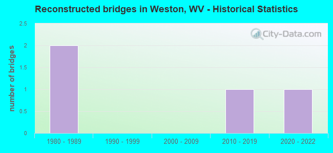
- Reconstructed bridges - Historical Statistics
- 21980-1989
- 01990-1999
- 02000-2009
- 12010-2019
- 12020-2022
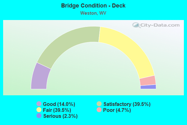
- Bridge Condition - Deck
- 14.0%Good
- 39.5%Satisfactory
- 39.5%Fair
- 4.7%Poor
- 2.3%Serious
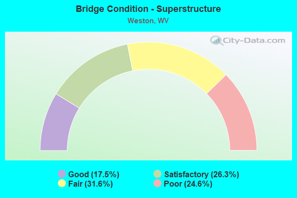
- Bridge Condition - Superstructure
- 17.5%Good
- 26.3%Satisfactory
- 31.6%Fair
- 24.6%Poor
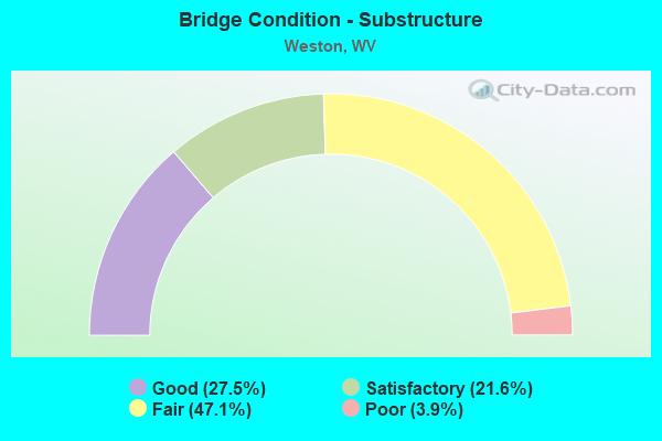
- Bridge Condition - Substructure
- 27.5%Good
- 21.6%Satisfactory
- 47.1%Fair
- 3.9%Poor
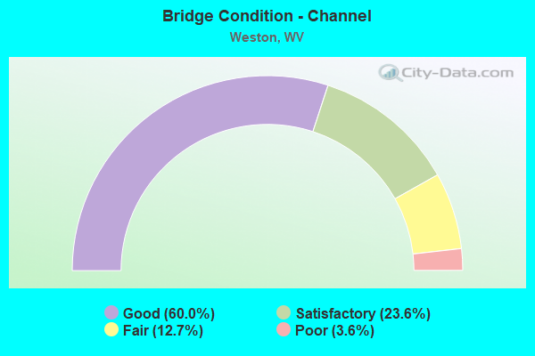
- Bridge Condition - Channel
- 60.0%Good
- 23.6%Satisfactory
- 12.7%Fair
- 3.6%Poor
Find on map >> Show street view
Structure Number: 21A002, Location: 0.06 MI N OF CO 1/7 (Lat: 39.086589, Lng: -80.475611), Route carried "on" structure: County highway 100, Year Built: 1924, Status: Open, Structure Length: 1.17m (3.84ft), Average Daily Traffic: 1,700 (year 2015), Truck Traffic: 5%, Average Future Daily Traffic: 2,278 (year 2035), Features Intersected: GEELICK RUN, Facility Carried by Structure: GEELICK RUN
Minimum Vertical Clearance: 30+ m (98+ ft), Kilometerpoint: 6.727, Lanes on structure: 2, Owner: State Highway Agency, Approaching Roadway Width: 7.3m (24.0ft), Material/Design: Concrete, Design/Construction: Arch - Deck, Number Of Spans In Main Unit: 1, Length of Maximum Span: 9.5m (31.2ft), Curb-To-Curb Width: 7.7m (25.3ft), Out-to-Out Width: 8.2m (26.9ft)
Condition: Superstructure: Poor, Substructure: Fair, Channel: Poor, Operating Rating: 63.5 metric tons, Method Used To Determine Operating Rating: Field evaluation and documented engineering judgment, Inventory Rating: 29.0 metric tons, Method Used To Determine Inventory Rating: Field evaluation and documented engineering judgment, Structural Evaluation: Meets minimum limits, Deck Geometry: Meets minimum limits, Waterway Adequacy: Equal to present minimum criteria, Approach Roadway Alignment: Equal to present desirable criteria, Length Of Structure Improvement: 1.52m (4.99ft), Designated Inspection Frequency: Every 24 months, Inspection Date: July 2020, Bridge Improvement Cost: $200,000, Roadway Improvement Cost: $30,000, Total Project Cost: $270,000 ( Estimate for 2020)
Find on map >> Show street view
Structure Number: 21A027, Location: 0.01 MI W OF CO 9/5 SLS (Lat: 39.096450, Lng: -80.526050), Route carried "on" structure: County highway 1000, Year Built: 1925, Status: Open, Structure Length: 1.00m (3.28ft), Average Daily Traffic: 700 (year 2018), Truck Traffic: 5%, Average Future Daily Traffic: 938 (year 2038), Features Intersected: RIGHT FORK FREEMANS CK, Facility Carried by Structure: COUNTY ROUTE 10
Minimum Vertical Clearance: 30+ m (98+ ft), Kilometerpoint: 20.584, Lanes on structure: 2, Owner: State Highway Agency, Approaching Roadway Width: 6.1m (20.0ft), Material/Design: Concrete, Design/Construction: Arch - Deck, Number Of Spans In Main Unit: 1, Length of Maximum Span: 8.8m (28.9ft), Curb-To-Curb Width: 5.6m (18.4ft), Out-to-Out Width: 5.6m (18.4ft)
Condition: Superstructure: Fair, Substructure: Fair, Channel: Good, Operating Rating: 47.2 metric tons, Method Used To Determine Operating Rating: Field evaluation and documented engineering judgment, Inventory Rating: 21.8 metric tons, Method Used To Determine Inventory Rating: Field evaluation and documented engineering judgment, Structural Evaluation: Somewhat better than minimum adequacy, Deck Geometry: High priority of replacement, Waterway Adequacy: Superior to present desirable criteria, Approach Roadway Alignment: Equal to present desirable criteria, Length Of Structure Improvement: 1.52m (4.99ft), Designated Inspection Frequency: Every 24 months, Inspection Date: April 2021, Bridge Improvement Cost: $250,000, Roadway Improvement Cost: $75,000, Total Project Cost: $375,000 ( Estimate for 2021)
Find on map >> Show street view
Structure Number: 21A031, Location: 0.01 MI S CO 10 (Lat: 39.091089, Lng: -80.530039), Route carried "on" structure: County highway 1008, Year Built: 1914, Status: Open, Structure Length: 1.23m (4.04ft), Average Daily Traffic: 250 (year 2015), Truck Traffic: 5%, Average Future Daily Traffic: 275 (year 2035), Features Intersected: LEFT FORK OF FREEMANS CK, Facility Carried by Structure: COUNTY ROUTE 10/8
Minimum Vertical Clearance: 30+ m (98+ ft), Kilometerpoint: 3.895, Lanes on structure: 1, Owner: State Highway Agency, Approaching Roadway Width: 6.7m (22.0ft), Material/Design: Concrete, Design/Construction: Arch - Deck, Number Of Spans In Main Unit: 1, Length of Maximum Span: 12.3m (40.4ft), Curb or Sidewalk Widths: Left: 0.1m (0.3ft), Right: 0.1m (0.3ft), Curb-To-Curb Width: 4.3m (14.1ft), Out-to-Out Width: 5.2m (17.1ft)
Condition: Superstructure: Poor, Channel: Fair, Operating Rating: 47.2 metric tons, Method Used To Determine Operating Rating: Field evaluation and documented engineering judgment, Inventory Rating: 21.8 metric tons, Method Used To Determine Inventory Rating: Field evaluation and documented engineering judgment, Structural Evaluation: Meets minimum limits, Deck Geometry: High priority of replacement, Waterway Adequacy: Equal to present desirable criteria, Approach Roadway Alignment: Equal to present minimum criteria, Length Of Structure Improvement: 1.86m (6.10ft), Designated Inspection Frequency: Every 24 months, Inspection Date: Febuary 2020, Bridge Improvement Cost: $160,000, Roadway Improvement Cost: $75,000, Total Project Cost: $300,000 ( Estimate for 2020)
Find on map >> Show street view
Structure Number: 21A045, Location: 0.11 MI S OF US 33 X (Lat: 38.999061, Lng: -80.384150), Route carried "on" structure: County highway 1500, Year Built: 1940, Status: Posted for load, Structure Length: 1.02m (3.35ft), Average Daily Traffic: 1,500 (year 2018), Truck Traffic: 9%, Average Future Daily Traffic: 1,725 (year 2038), Features Intersected: STONECOAL CREEK, Facility Carried by Structure: COUNTY ROUTE 15
Minimum Vertical Clearance: 30+ m (98+ ft), Kilometerpoint: 14.114, Lanes on structure: 2, Owner: State Highway Agency, Approaching Roadway Width: 8.5m (27.9ft), Material/Design: Steel, Design/Construction: Stringer/Multi-beam, Number Of Spans In Main Unit: 1, Length of Maximum Span: 9.1m (29.9ft), Curb-To-Curb Width: 7.3m (24.0ft), Out-to-Out Width: 8.2m (26.9ft)
Condition: Deck: Satisfactory, Superstructure: Fair, Substructure: Satisfactory, Channel: Fair, Operating Rating: 44.4 metric tons, Method Used To Determine Operating Rating: Load Factor (LF), Inventory Rating: 26.3 metric tons, Method Used To Determine Inventory Rating: Load Factor (LF), Structural Evaluation: Somewhat better than minimum adequacy, Deck Geometry: Meets minimum limits, Waterway Adequacy: Somewhat better than minimum adequacy, Approach Roadway Alignment: Equal to present desirable criteria, Bridge Posting: Required (Relationship of Operating Rating to Maximum Legal Load: 0.1 - 9.9% below), Length Of Structure Improvement: 1.37m (4.49ft), Designated Inspection Frequency: Every 24 months, Inspection Date: May 2021, Bridge Improvement Cost: $250,000, Roadway Improvement Cost: $100,000, Total Project Cost: $450,000 ( Estimate for 2021), Deck Structure Type: Concrete Cast-file-Place, Wearing Surface/Protective System: Wearing Surface: Bituminous
Find on map >> Show street view
Structure Number: 21A06, Location: 0.40 MI N OF US RT 33 F (Lat: 39.043361, Lng: -80.462119), Route carried "on" structure: US 1900, Year Built: 1929, Status: Open, Structure Length: 2.10m (6.89ft), Average Daily Traffic: 6,500 (year 2018), Truck Traffic: 10%, Average Future Daily Traffic: 6,800 (year 2038), Features Intersected: STONECOAL CREEK, Facility Carried by Structure: US ROUTE 19 SLS
Minimum Vertical Clearance: 30+ m (98+ ft), Kilometerpoint: 39.831, Lanes on structure: 2, Owner: State Highway Agency, Approaching Roadway Width: 11.6m (38.1ft), Material/Design: Concrete, Design/Construction: Girder and Floorbeam System, Number Of Spans In Main Unit: 1, Length of Maximum Span: 19.1m (62.7ft), Curb or Sidewalk Widths: Left: 0.2m (0.7ft), Right: 1.8m (5.9ft), Curb-To-Curb Width: 9.1m (29.9ft), Out-to-Out Width: 11.7m (38.4ft)
Condition: Deck: Fair, Superstructure: Poor, Substructure: Fair, Channel: Good, Operating Rating: 49.9 metric tons, Method Used To Determine Operating Rating: Load Factor (LF), Inventory Rating: 29.9 metric tons, Method Used To Determine Inventory Rating: Load Factor (LF), Structural Evaluation: Meets minimum limits, Deck Geometry: High priority of corrective action, Waterway Adequacy: Equal to present desirable criteria, Approach Roadway Alignment: Equal to present minimum criteria, Length Of Structure Improvement: 2.44m (8.01ft), Designated Inspection Frequency: Every 24 months, Inspection Date: June 2021, Bridge Improvement Cost: $1,200,000, Roadway Improvement Cost: $600,000, Total Project Cost: $2,200,000 ( Estimate for 2021), Deck Structure Type: Concrete Cast-file-Place, Wearing Surface/Protective System: Wearing Surface: Bituminous
Find on map >> Show street view
Structure Number: 21A061, Location: 0.14 MI N OF CO RT 12 SLS (Lat: 39.063939, Lng: -80.453000), Route carried "on" structure: US 1900, Year Built: 1927, Status: Open, Structure Length: 0.88m (2.89ft), Average Daily Traffic: 2,300 (year 2018), Truck Traffic: 14%, Average Future Daily Traffic: 2,620 (year 2038), Features Intersected: MAXWELL RUN, Facility Carried by Structure: US 19 SLS
Minimum Vertical Clearance: 30+ m (98+ ft), Kilometerpoint: 42.776, Lanes on structure: 2, Owner: State Highway Agency, Approaching Roadway Width: 9.8m (32.2ft), Material/Design: Concrete, Design/Construction: Slab, Number Of Spans In Main Unit: 1, Length of Maximum Span: 7.9m (25.9ft), Curb-To-Curb Width: 6.9m (22.6ft), Out-to-Out Width: 7.5m (24.6ft)
Condition: Deck: Fair, Superstructure: Fair, Substructure: Fair, Channel: Fair, Operating Rating: 63.5 metric tons, Method Used To Determine Operating Rating: Field evaluation and documented engineering judgment, Inventory Rating: 29.0 metric tons, Method Used To Determine Inventory Rating: Field evaluation and documented engineering judgment, Structural Evaluation: Somewhat better than minimum adequacy, Deck Geometry: High priority of replacement, Waterway Adequacy: Superior to present desirable criteria, Approach Roadway Alignment: Equal to present desirable criteria, Length Of Structure Improvement: 1.19m (3.90ft), Designated Inspection Frequency: Every 24 months, Inspection Date: March 2021, Bridge Improvement Cost: $84,000, Roadway Improvement Cost: $83,000, Total Project Cost: $212,000 ( Estimate for 2021), Deck Structure Type: Concrete Cast-file-Place, Wearing Surface/Protective System: Wearing Surface: Bituminous
Find on map >> Show street view
Structure Number: 21A062, Location: 0.14 MI N OF CO 19/26 SLS (Lat: 39.064369, Lng: -80.441169), Route carried "on" structure: US 1900, Year Built: 1929, Status: Open, Structure Length: 0.90m (2.95ft), Average Daily Traffic: 2,300 (year 2018), Truck Traffic: 14%, Average Future Daily Traffic: 3,082 (year 2038), Features Intersected: MAXWELL RUN, Facility Carried by Structure: US 19 SLS
Minimum Vertical Clearance: 30+ m (98+ ft), Kilometerpoint: 43.806, Lanes on structure: 2, Owner: State Highway Agency, Approaching Roadway Width: 8.2m (26.9ft), Skew: 4 degrees, Material/Design: Concrete, Design/Construction: Slab, Number Of Spans In Main Unit: 1, Length of Maximum Span: 8.4m (27.6ft), Curb-To-Curb Width: 9.4m (30.8ft), Out-to-Out Width: 9.4m (30.8ft)
Condition: Deck: Poor, Superstructure: Poor, Substructure: Fair, Channel: Satisfactory, Operating Rating: 49.0 metric tons, Method Used To Determine Operating Rating: Field evaluation and documented engineering judgment, Inventory Rating: 29.0 metric tons, Method Used To Determine Inventory Rating: Field evaluation and documented engineering judgment, Structural Evaluation: Meets minimum limits, Deck Geometry: Meets minimum limits, Waterway Adequacy: Equal to present desirable criteria, Approach Roadway Alignment: Equal to present desirable criteria, Length Of Structure Improvement: 1.22m (4.00ft), Designated Inspection Frequency: Every 24 months, Inspection Date: October 2020, Bridge Improvement Cost: $250,000, Roadway Improvement Cost: $100,000, Total Project Cost: $450,000 ( Estimate for 2020), Deck Structure Type: Concrete Cast-file-Place, Wearing Surface/Protective System: Wearing Surface: Bituminous
Find on map >> Show street view
Structure Number: 21A07, Location: 0.02 MI W CO 20/2 (Lat: 39.028181, Lng: -80.528481), Route carried "on" structure: County highway 2200, Year Built: 1923, Status: Open, Structure Length: 0.73m (2.40ft), Average Daily Traffic: 200 (year 2015), Truck Traffic: 5%, Average Future Daily Traffic: 228 (year 2035), Features Intersected: LIMESTONE RUN, Facility Carried by Structure: COUNTY ROUTE 22
Minimum Vertical Clearance: 30+ m (98+ ft), Kilometerpoint: 7.129, Lanes on structure: 1, Owner: State Highway Agency, Approaching Roadway Width: 6.7m (22.0ft), Material/Design: Concrete, Design/Construction: Arch - Deck, Number Of Spans In Main Unit: 1, Length of Maximum Span: 7.3m (24.0ft), Curb or Sidewalk Widths: Left: 0.1m (0.3ft), Right: 0.1m (0.3ft), Curb-To-Curb Width: 4.7m (15.4ft), Out-to-Out Width: 5.4m (17.7ft)
Condition: Deck: Fair, Superstructure: Satisfactory, Substructure: Fair, Channel: Poor, Operating Rating: 47.2 metric tons, Method Used To Determine Operating Rating: Field evaluation and documented engineering judgment, Inventory Rating: 21.8 metric tons, Method Used To Determine Inventory Rating: Field evaluation and documented engineering judgment, Structural Evaluation: Somewhat better than minimum adequacy, Deck Geometry: High priority of replacement, Waterway Adequacy: High priority of corrective action, Approach Roadway Alignment: Equal to present desirable criteria, Length Of Structure Improvement: 1.07m (3.51ft), Designated Inspection Frequency: Every 24 months, Inspection Date: May 2020, Bridge Improvement Cost: $120,000, Roadway Improvement Cost: $40,000, Total Project Cost: $185,000 ( Estimate for 2020), Deck Structure Type: Concrete Cast-file-Place, Wearing Surface/Protective System: Wearing Surface: Bituminous
Find on map >> Show street view
Structure Number: 21A074, Location: 0.26 MI N CO 24/4 (Lat: 38.995189, Lng: -80.512639), Route carried "on" structure: County highway 2400, Year Built: 1923, Status: Open, Structure Length: 0.90m (2.95ft), Average Daily Traffic: 275 (year 2015), Truck Traffic: 5%, Average Future Daily Traffic: 300 (year 2035), Features Intersected: JENNINGS RUN, Facility Carried by Structure: COUNTY ROUTE 24
Minimum Vertical Clearance: 30+ m (98+ ft), Kilometerpoint: 0.724, Lanes on structure: 1, Owner: State Highway Agency, Approaching Roadway Width: 5.2m (17.1ft), Skew: 3 degrees, Material/Design: Concrete, Design/Construction: Arch - Deck, Number Of Spans In Main Unit: 1, Length of Maximum Span: 9.0m (29.5ft), Curb-To-Curb Width: 4.3m (14.1ft), Out-to-Out Width: 4.3m (14.1ft)
Condition: Superstructure: Fair, Substructure: Good, Channel: Fair, Operating Rating: 47.2 metric tons, Method Used To Determine Operating Rating: Field evaluation and documented engineering judgment, Inventory Rating: 21.8 metric tons, Method Used To Determine Inventory Rating: Field evaluation and documented engineering judgment, Structural Evaluation: Somewhat better than minimum adequacy, Deck Geometry: High priority of replacement, Waterway Adequacy: Equal to present desirable criteria, Approach Roadway Alignment: Better than present minimum criteria, Length Of Structure Improvement: 1.62m (5.31ft), Designated Inspection Frequency: Every 24 months, Inspection Date: January 2020, Bridge Improvement Cost: $158,000, Roadway Improvement Cost: $156,000, Total Project Cost: $419,000 ( Estimate for 2020)
Find on map >> Show street view
Structure Number: 21A089, Location: 0.04 MI W OF CO RT 119/11 (Lat: 39.048011, Lng: -80.533689), Route carried "on" structure: US 3300, Year Built: 1921, Status: Open, Structure Length: 0.75m (2.46ft), Average Daily Traffic: 3,000 (year 2018), Truck Traffic: 14%, Average Future Daily Traffic: 4,130 (year 2038), Features Intersected: DRY FORK, Facility Carried by Structure: US ROUTE 33 F
Minimum Vertical Clearance: 30+ m (98+ ft), Kilometerpoint: 21.115, Lanes on structure: 2, Base Highway Network: Yes, Owner: State Highway Agency, Approaching Roadway Width: 9.1m (29.9ft), Skew: 2 degrees, Material/Design: Concrete, Design/Construction: Slab, Number Of Spans In Main Unit: 1, Length of Maximum Span: 6.7m (22.0ft), Curb-To-Curb Width: 9.1m (29.9ft), Out-to-Out Width: 9.6m (31.5ft)
Condition: Deck: Poor, Superstructure: Poor, Substructure: Satisfactory, Channel: Good, Operating Rating: 63.5 metric tons, Method Used To Determine Operating Rating: Field evaluation and documented engineering judgment, Inventory Rating: 29.0 metric tons, Method Used To Determine Inventory Rating: Field evaluation and documented engineering judgment, Structural Evaluation: Meets minimum limits, Deck Geometry: Meets minimum limits, Waterway Adequacy: Equal to present desirable criteria, Approach Roadway Alignment: Equal to present desirable criteria, Length Of Structure Improvement: 1.22m (4.00ft), Designated Inspection Frequency: Every 24 months, Inspection Date: April 2021, Bridge Improvement Cost: $350,000, Roadway Improvement Cost: $100,000, Total Project Cost: $500,000 ( Estimate for 2021), Deck Structure Type: Concrete Cast-file-Place, Wearing Surface/Protective System: Wearing Surface: Bituminous
Find on map >> Show street view
Structure Number: 21A09, Location: 0.23 MI E OF CO 119/15 (Lat: 39.048000, Lng: -80.479669), Route carried "on" structure: US 3300, Year Built: 1931, Status: Open, Structure Length: 1.94m (6.36ft), Average Daily Traffic: 10,000 (year 2018), Truck Traffic: 7%, Average Future Daily Traffic: 13,400 (year 2038), Features Intersected: POLK CREEK, Facility Carried by Structure: US ROUTE 33
Minimum Vertical Clearance: 30+ m (98+ ft), Kilometerpoint: 26.120, Lanes on structure: 2, Base Highway Network: Yes, Owner: State Highway Agency, Approaching Roadway Width: 10.4m (34.1ft), Skew: 2 degrees, Material/Design: Concrete, Design/Construction: Arch - Deck, Number Of Spans In Main Unit: 1, Length of Maximum Span: 18.3m (60.0ft), Curb or Sidewalk Widths: Left: 1.8m (5.9ft), Right: 0.0m, Curb-To-Curb Width: 9.3m (30.5ft), Out-to-Out Width: 10.2m (33.5ft)
Condition: Superstructure: Fair, Channel: Good, Operating Rating: 55.3 metric tons, Method Used To Determine Operating Rating: Field evaluation and documented engineering judgment, Inventory Rating: 23.6 metric tons, Method Used To Determine Inventory Rating: Field evaluation and documented engineering judgment, Structural Evaluation: Somewhat better than minimum adequacy, Deck Geometry: High priority of corrective action, Waterway Adequacy: Equal to present desirable criteria, Approach Roadway Alignment: Equal to present desirable criteria, Length Of Structure Improvement: 1.95m (6.40ft), Designated Inspection Frequency: Every 24 months, Inspection Date: October 2020, Bridge Improvement Cost: $43,000, Roadway Improvement Cost: $30,000, Total Project Cost: $86,000 ( Estimate for 2021)
Find on map >> Show street view
Structure Number: 21A091, Location: 0.01 MI E OF CO RT 1 SLS (Lat: 39.038781, Lng: -80.468150), Route carried "on" structure: US 3300, Year Built: 1922, Status: Open, Structure Length: 5.04m (16.54ft), Average Daily Traffic: 12,200 (year 2018), Truck Traffic: 13%, Average Future Daily Traffic: 16,800 (year 2038), Features Intersected: WEST FORK RIVER, Facility Carried by Structure: US ROUTE 33 F
Minimum Vertical Clearance: 30+ m (98+ ft), Kilometerpoint: 27.568, Lanes on structure: 2, Base Highway Network: Yes, Owner: State Highway Agency, Approaching Roadway Width: 15.2m (49.9ft), Material/Design: Concrete, Design/Construction: Arch - Deck, Number Of Spans In Main Unit: 2, Length of Maximum Span: 20.7m (67.9ft), Curb or Sidewalk Widths: Left: 1.8m (5.9ft), Right: 1.7m (5.6ft), Curb-To-Curb Width: 9.6m (31.5ft), Out-to-Out Width: 14.1m (46.3ft)
Condition: Superstructure: Poor, Substructure: Fair, Channel: Good, Operating Rating: 55.3 metric tons, Method Used To Determine Operating Rating: Field evaluation and documented engineering judgment, Inventory Rating: 21.8 metric tons, Method Used To Determine Inventory Rating: Field evaluation and documented engineering judgment, Structural Evaluation: Meets minimum limits, Deck Geometry: High priority of corrective action, Waterway Adequacy: Superior to present desirable criteria, Approach Roadway Alignment: Equal to present desirable criteria, Length Of Structure Improvement: 5.03m (16.50ft), Designated Inspection Frequency: Every 24 months, Inspection Date: May 2021, Bridge Improvement Cost: $1,500,000, Roadway Improvement Cost: $200,000, Total Project Cost: $2,000,000 ( Estimate for 2021)
Find on map >> Show street view
Structure Number: 21A093, Location: 0.08 MI W OF CO 119/18 (Lat: 39.013639, Lng: -80.406850), Route carried "on" structure: US 3300, Year Built: 1974, Status: Open, Structure Length: 4.14m (13.58ft), Average Daily Traffic: 12,450 (year 2018), Truck Traffic: 10%, Average Future Daily Traffic: 13,070 (year 2038), Design Load: HS 20, Features Intersected: STONECOAL CREEK, Facility Carried by Structure: US 33 EBL
Minimum Vertical Clearance: 30+ m (98+ ft), Kilometerpoint: 34.166, Lanes on structure: 2, Base Highway Network: Yes, Owner: State Highway Agency, Approaching Roadway Width: 14.0m (45.9ft), Skew: 4 degrees, Material/Design: Steel continuous, Design/Construction: Stringer/Multi-beam, Number Of Spans In Main Unit: 1, Number Of Approach Spans: 2, Length of Maximum Span: 15.9m (52.2ft), Curb or Sidewalk Widths: Left: 0.3m (1.0ft), Right: 0.3m (1.0ft), Curb-To-Curb Width: 12.3m (40.4ft), Out-to-Out Width: 13.6m (44.6ft)
Condition: Deck: Fair, Superstructure: Satisfactory, Substructure: Fair, Channel: Satisfactory, Operating Rating: 59.9 metric tons, Method Used To Determine Operating Rating: Load Factor (LF), Inventory Rating: 36.3 metric tons, Method Used To Determine Inventory Rating: Load Factor (LF), Structural Evaluation: Somewhat better than minimum adequacy, Deck Geometry: Better than present minimum criteria, Waterway Adequacy: Superior to present desirable criteria, Approach Roadway Alignment: Equal to present desirable criteria, Length Of Structure Improvement: 4.15m (13.62ft), Designated Inspection Frequency: Every 24 months, Inspection Date: May 2021, Bridge Improvement Cost: $370,000, Roadway Improvement Cost: $30,000, Total Project Cost: $600,000 ( Estimate for 2021), Deck Structure Type: Concrete Cast-file-Place, Wearing Surface/Protective System: Wearing Surface: Latex Concrete
Find on map >> Show street view
Structure Number: 21A094, Location: 0.09 MI W OF CO 119/21 (Lat: 39.004869, Lng: -80.392611), Route carried "on" structure: US 3300, Year Built: 1974, Status: Open, Structure Length: 4.37m (14.34ft), Average Daily Traffic: 7,450 (year 2018), Truck Traffic: 10%, Average Future Daily Traffic: 7,820 (year 2038), Design Load: HS 20, Features Intersected: STONECOAL CREEK, Facility Carried by Structure: US 33 EBL
Minimum Vertical Clearance: 30+ m (98+ ft), Kilometerpoint: 35.760, Lanes on structure: 2, Base Highway Network: Yes, Owner: State Highway Agency, Approaching Roadway Width: 14.0m (45.9ft), Material/Design: Steel continuous, Design/Construction: Stringer/Multi-beam, Number Of Spans In Main Unit: 1, Number Of Approach Spans: 2, Length of Maximum Span: 16.5m (54.1ft), Curb or Sidewalk Widths: Left: 0.3m (1.0ft), Right: 0.3m (1.0ft), Curb-To-Curb Width: 12.3m (40.4ft), Out-to-Out Width: 13.6m (44.6ft)
Condition: Deck: Fair, Superstructure: Satisfactory, Substructure: Fair, Channel: Good, Operating Rating: 58.0 metric tons, Method Used To Determine Operating Rating: Load Factor (LF), Inventory Rating: 34.5 metric tons, Method Used To Determine Inventory Rating: Load Factor (LF), Structural Evaluation: Somewhat better than minimum adequacy, Deck Geometry: Better than present minimum criteria, Waterway Adequacy: Superior to present desirable criteria, Approach Roadway Alignment: Equal to present desirable criteria, Designated Inspection Frequency: Every 24 months, Inspection Date: May 2021, Deck Structure Type: Concrete Cast-file-Place, Wearing Surface/Protective System: Wearing Surface: Latex Concrete
Find on map >> Show street view
Structure Number: 21A095, Location: 0.06 MI E CO 13 (Lat: 39.022961, Lng: -80.415131), Route carried "on" structure: County highway 3301, Year Built: 1918, Status: Open, Structure Length: 0.91m (2.99ft), Average Daily Traffic: 225 (year 2015), Truck Traffic: 5%, Average Future Daily Traffic: 250 (year 2035), Features Intersected: HILLY UPLAND RUN, Facility Carried by Structure: COUNTY ROUTE 33/1
Minimum Vertical Clearance: 30+ m (98+ ft), Kilometerpoint: 1.014, Lanes on structure: 2, Owner: State Highway Agency, Approaching Roadway Width: 7.9m (25.9ft), Skew: 1 degrees, Material/Design: Concrete, Design/Construction: Slab, Number Of Spans In Main Unit: 1, Length of Maximum Span: 8.1m (26.6ft), Curb-To-Curb Width: 6.2m (20.3ft), Out-to-Out Width: 6.3m (20.7ft)
Condition: Superstructure: Fair, Substructure: Fair, Channel: Satisfactory, Operating Rating: 47.2 metric tons, Method Used To Determine Operating Rating: Field evaluation and documented engineering judgment, Inventory Rating: 21.8 metric tons, Method Used To Determine Inventory Rating: Field evaluation and documented engineering judgment, Structural Evaluation: Somewhat better than minimum adequacy, Deck Geometry: Meets minimum limits, Waterway Adequacy: Equal to present desirable criteria, Approach Roadway Alignment: Equal to present minimum criteria, Length Of Structure Improvement: 1.55m (5.09ft), Designated Inspection Frequency: Every 24 months, Inspection Date: January 2020, Bridge Improvement Cost: $174,000, Roadway Improvement Cost: $172,000, Total Project Cost: $416,000 ( Estimate for 2018), Deck Structure Type: Concrete Cast-file-Place, Wearing Surface/Protective System: Wearing Surface: Bituminous
Find on map >> Show street view
Structure Number: 21A098, Location: 0.01 MI S OF CO 38/6 (Lat: 39.014769, Lng: -80.477161), Route carried "on" structure: County highway 3803, Year Built: 1952, Status: Posted for load, Structure Length: 5.30m (17.39ft), Average Daily Traffic: 11 (year 2015), Truck Traffic: 5%, Average Future Daily Traffic: 13 (year 2035), Features Intersected: WEST FORK RIVER, Facility Carried by Structure: COUNTY ROUTE 38/3
Minimum Vertical Clearance: 30+ m (98+ ft), Kilometerpoint: 0.177, Lanes on structure: 1, Owner: State Highway Agency, Approaching Roadway Width: 6.1m (20.0ft), Material/Design: Steel, Design/Construction: Girder and Floorbeam System, Number Of Spans In Main Unit: 2, Number Of Approach Spans: 2, Length of Maximum Span: 14.9m (48.9ft), Curb or Sidewalk Widths: Left: 0.2m (0.7ft), Right: 0.2m (0.7ft), Curb-To-Curb Width: 3.7m (12.1ft), Out-to-Out Width: 3.7m (12.1ft)
Condition: Deck: Fair, Superstructure: Poor, Substructure: Fair, Channel: Good, Operating Rating: 29.0 metric tons, Method Used To Determine Operating Rating: Load Factor (LF), Inventory Rating: 17.2 metric tons, Method Used To Determine Inventory Rating: Load Factor (LF), Structural Evaluation: Meets minimum limits, Deck Geometry: Meets minimum limits, Waterway Adequacy: Superior to present desirable criteria, Approach Roadway Alignment: Equal to present minimum criteria, Bridge Posting: Required (Relationship of Operating Rating to Maximum Legal Load: 0.1 - 9.9% below), Length Of Structure Improvement: 6.10m (20.01ft), Designated Inspection Frequency: Every 24 months, Critical Feature Inspection Frequency: Every 24 months, Underwater Inspection Frequency: Every 60 months, Inspection Date: August 2020, Critical Feature Inspection Date: June 2020, Underwater Inspection Date: July 2021, Bridge Improvement Cost: $600,000, Roadway Improvement Cost: $200,000, Total Project Cost: $1,000,000 ( Estimate for 2020), Deck Structure Type: Wood or Timber
Find on map >> Show street view
Structure Number: 21A117, Location: 2.87 MI S US 33 (Lat: 39.014569, Lng: -80.471769), Route carried "on" structure: Interstate 7900, Year Built: 1972, Status: Open, Structure Length: 13.44m (44.09ft), Average Daily Traffic: 9,800 (year 2015), Truck Traffic: 27%, Average Future Daily Traffic: 14,425 (year 2035), Design Load: HS 20+Mod, Features Intersected: W Fk Rvr Co 19/39 & 38/3, Facility Carried by Structure: I-79 N
Minimum Vertical Clearance: 30+ m (98+ ft), Kilometerpoint: 154.063, Lanes on structure: 2, Lanes under structure: 2, Base Highway Network: Yes, Owner: State Highway Agency, Approaching Roadway Width: 14.0m (45.9ft), Skew: 2 degrees, Material/Design: Steel continuous, Design/Construction: Stringer/Multi-beam, Number Of Spans In Main Unit: 1, Number Of Approach Spans: 4, Length of Maximum Span: 39.6m (129.9ft), Curb-To-Curb Width: 12.3m (40.4ft), Out-to-Out Width: 13.6m (44.6ft)
Condition: Deck: Fair, Superstructure: Fair, Substructure: Fair, Channel: Good, Operating Rating: 62.6 metric tons, Method Used To Determine Operating Rating: Load Factor (LF), Inventory Rating: 37.2 metric tons, Method Used To Determine Inventory Rating: Load Factor (LF), Structural Evaluation: Somewhat better than minimum adequacy, Deck Geometry: Better than present minimum criteria, Underclear: Superior to present desirable criteria, Waterway Adequacy: Superior to present desirable criteria, Approach Roadway Alignment: Equal to present desirable criteria, Length Of Structure Improvement: 13.44m (44.09ft), Designated Inspection Frequency: Every 24 months, Inspection Date: January 2020, Bridge Improvement Cost: $1,200,000, Roadway Improvement Cost: $100,000, Total Project Cost: $1,500,000 ( Estimate for 2020), Deck Structure Type: Concrete Cast-file-Place, Wearing Surface/Protective System: Wearing Surface: Latex Concrete
Find on map >> Show street view
Structure Number: 21A118, Location: 2.87 M1 S OF US 33 (Lat: 39.014339, Lng: -80.471619), Route carried "on" structure: Interstate 7900, Year Built: 1972, Status: Open, Structure Length: 13.44m (44.09ft), Average Daily Traffic: 9,500 (year 2018), Truck Traffic: 27%, Average Future Daily Traffic: 13,968 (year 2038), Design Load: HS 20+Mod, Features Intersected: W Fk Rvr Co 19/39 & 38/3, Facility Carried by Structure: I-79 S
Minimum Vertical Clearance: 30+ m (98+ ft), Kilometerpoint: 154.063, Lanes on structure: 3, Lanes under structure: 4, Base Highway Network: Yes, Owner: State Highway Agency, Approaching Roadway Width: 14.0m (45.9ft), Skew: 2 degrees, Material/Design: Steel continuous, Design/Construction: Stringer/Multi-beam, Number Of Spans In Main Unit: 1, Number Of Approach Spans: 4, Length of Maximum Span: 39.6m (129.9ft), Curb-To-Curb Width: 15.8m (51.8ft), Out-to-Out Width: 16.8m (55.1ft)
Condition: Deck: Fair, Superstructure: Fair, Substructure: Satisfactory, Channel: Good, Operating Rating: 60.8 metric tons, Method Used To Determine Operating Rating: Load Factor (LF), Inventory Rating: 36.3 metric tons, Method Used To Determine Inventory Rating: Load Factor (LF), Structural Evaluation: Somewhat better than minimum adequacy, Deck Geometry: Somewhat better than minimum adequacy, Underclear: Superior to present desirable criteria, Waterway Adequacy: Superior to present desirable criteria, Approach Roadway Alignment: Equal to present desirable criteria, Length Of Structure Improvement: 13.44m (44.09ft), Designated Inspection Frequency: Every 24 months, Inspection Date: January 2020, Bridge Improvement Cost: $1,200,000, Roadway Improvement Cost: $100,000, Total Project Cost: $1,500,000 ( Estimate for 2020), Deck Structure Type: Concrete Cast-file-Place, Wearing Surface/Protective System: Wearing Surface: Latex Concrete
Find on map >> Show street view
Structure Number: 21A121, Location: 0.20 MI S US 33 (Lat: 39.019731, Lng: -80.429200), Route carried "on" structure: Interstate 7900, Year Built: 1972, Status: Open, Structure Length: 9.39m (30.81ft), Average Daily Traffic: 11,350 (year 2018), Truck Traffic: 28%, Average Future Daily Traffic: 16,700 (year 2038), Design Load: HS 20+Mod, Features Intersected: STONECOAL CREEK, Facility Carried by Structure: I-79 N
Minimum Vertical Clearance: 30+ m (98+ ft), Kilometerpoint: 158.359, Lanes on structure: 2, Base Highway Network: Yes, Owner: State Highway Agency, Approaching Roadway Width: 14.0m (45.9ft), Skew: 3 degrees, Material/Design: Steel continuous, Design/Construction: Stringer/Multi-beam, Number Of Spans In Main Unit: 1, Number Of Approach Spans: 2, Length of Maximum Span: 36.3m (119.1ft), Curb-To-Curb Width: 12.3m (40.4ft), Out-to-Out Width: 13.6m (44.6ft)
Condition: Deck: Fair, Superstructure: Poor, Substructure: Fair, Channel: Good, Operating Rating: 57.1 metric tons, Method Used To Determine Operating Rating: Load Factor (LF), Inventory Rating: 34.5 metric tons, Method Used To Determine Inventory Rating: Load Factor (LF), Structural Evaluation: Meets minimum limits, Deck Geometry: Better than present minimum criteria, Waterway Adequacy: Superior to present desirable criteria, Approach Roadway Alignment: Equal to present desirable criteria, Length Of Structure Improvement: 9.45m (31.00ft), Designated Inspection Frequency: Every 24 months, Other Special Inspection Frequency: Every 12 months, Inspection Date: April 2021, Other Special Inspection Date: April 2021, Bridge Improvement Cost: $5,000,000, Roadway Improvement Cost: $500,000, Total Project Cost: $6,000,000 ( Estimate for 2021), Deck Structure Type: Concrete Cast-file-Place, Wearing Surface/Protective System: Wearing Surface: Latex Concrete
Find on map >> Show street view
Structure Number: 21A122, Location: 0.20 MI S US 33 (Lat: 39.019689, Lng: -80.429250), Route carried "on" structure: Interstate 7900, Year Built: 1972, Status: Open, Structure Length: 9.67m (31.73ft), Average Daily Traffic: 11,350 (year 2018), Truck Traffic: 28%, Average Future Daily Traffic: 16,700 (year 2038), Design Load: HS 20+Mod, Features Intersected: STONECOAL CREEK, Facility Carried by Structure: I-79 S
Minimum Vertical Clearance: 30+ m (98+ ft), Kilometerpoint: 158.359, Lanes on structure: 2, Base Highway Network: Yes, Owner: State Highway Agency, Approaching Roadway Width: 14.0m (45.9ft), Skew: 3 degrees, Material/Design: Steel continuous, Design/Construction: Stringer/Multi-beam, Number Of Spans In Main Unit: 1, Number Of Approach Spans: 2, Length of Maximum Span: 36.3m (119.1ft), Curb-To-Curb Width: 12.5m (41.0ft), Out-to-Out Width: 13.8m (45.3ft)
Condition: Deck: Fair, Superstructure: Poor, Substructure: Fair, Channel: Good, Operating Rating: 58.0 metric tons, Method Used To Determine Operating Rating: Load Factor (LF), Inventory Rating: 35.4 metric tons, Method Used To Determine Inventory Rating: Load Factor (LF), Structural Evaluation: Meets minimum limits, Deck Geometry: Better than present minimum criteria, Waterway Adequacy: Superior to present desirable criteria, Approach Roadway Alignment: Equal to present desirable criteria, Length Of Structure Improvement: 9.45m (31.00ft), Designated Inspection Frequency: Every 24 months, Other Special Inspection Frequency: Every 12 months, Inspection Date: April 2021, Other Special Inspection Date: April 2021, Bridge Improvement Cost: $5,000,000, Roadway Improvement Cost: $500,000, Total Project Cost: $6,000,000 ( Estimate for 2021), Deck Structure Type: Concrete Cast-file-Place, Wearing Surface/Protective System: Wearing Surface: Latex Concrete
Find on map >> Show street view
Structure Number: 21A123, Location: 0.19 MI S OF US 33 (Lat: 39.019750, Lng: -80.428661), Route carried "on" structure: Ramp Interstate 7900, Year Built: 1972, Status: Open, Structure Length: 10.22m (33.53ft), Average Daily Traffic: 8,750 (year 2015), Truck Traffic: 20%, Average Future Daily Traffic: 12,866 (year 2035), Design Load: HS 20+Mod, Features Intersected: STONECOAL CREEK, Facility Carried by Structure: I-79 NBL EXIT RAMP
Minimum Vertical Clearance: 30+ m (98+ ft), Kilometerpoint: 158.376, Lanes on structure: 1, Owner: State Highway Agency, Approaching Roadway Width: 9.4m (30.8ft), Skew: 3 degrees, Material/Design: Steel continuous, Design/Construction: Stringer/Multi-beam, Number Of Spans In Main Unit: 1, Number Of Approach Spans: 2, Length of Maximum Span: 39.0m (128.0ft), Curb-To-Curb Width: 8.1m (26.6ft), Out-to-Out Width: 9.3m (30.5ft)
Condition: Deck: Fair, Superstructure: Fair, Substructure: Fair, Channel: Good, Operating Rating: 59.0 metric tons, Method Used To Determine Operating Rating: Load Factor (LF), Inventory Rating: 35.4 metric tons, Method Used To Determine Inventory Rating: Load Factor (LF), Structural Evaluation: Somewhat better than minimum adequacy, Deck Geometry: Superior to present desirable criteria, Waterway Adequacy: Equal to present desirable criteria, Approach Roadway Alignment: Equal to present desirable criteria, Length Of Structure Improvement: 10.21m (33.50ft), Designated Inspection Frequency: Every 24 months, Inspection Date: December 2019, Bridge Improvement Cost: $316,000, Roadway Improvement Cost: $10,000, Total Project Cost: $400,000 ( Estimate for 2018), Deck Structure Type: Concrete Cast-file-Place, Wearing Surface/Protective System: Wearing Surface: Latex Concrete
Find on map >> Show street view
Structure Number: 21A124, Location: 2.81 MI N OF CO 19/39 (Lat: 39.021700, Lng: -80.427750), Route carried "on" structure: Interstate 7900, Year Built: 1972, Status: Open, Structure Length: 6.22m (20.41ft), Average Daily Traffic: 10,316 (year 2015), Truck Traffic: 27%, Average Future Daily Traffic: 15,168 (year 2035), Design Load: HS 20+Mod, Features Intersected: US 33, Facility Carried by Structure: INTERSTATE 79
Minimum Vertical Clearance: 30+ m (98+ ft), Kilometerpoint: 158.633, Lanes on structure: 2, Lanes under structure: 6, Base Highway Network: Yes, Owner: State Highway Agency, Approaching Roadway Width: 14.0m (45.9ft), Skew: 1 degrees, Material/Design: Steel continuous, Design/Construction: Stringer/Multi-beam, Number Of Spans In Main Unit: 2, Length of Maximum Span: 30.5m (100.1ft), Curb-To-Curb Width: 12.3m (40.4ft), Out-to-Out Width: 13.6m (44.6ft)
Condition: Deck: Fair, Superstructure: Satisfactory, Substructure: Fair, Operating Rating: 62.6 metric tons, Method Used To Determine Operating Rating: Load Factor (LF), Inventory Rating: 37.2 metric tons, Method Used To Determine Inventory Rating: Load Factor (LF), Structural Evaluation: Somewhat better than minimum adequacy, Deck Geometry: Better than present minimum criteria, Underclear: High priority of corrective action, Approach Roadway Alignment: Superior to present desirable criteria, Designated Inspection Frequency: Every 24 months, Inspection Date: April 2020, Deck Structure Type: Concrete Cast-file-Place, Wearing Surface/Protective System: Wearing Surface: Latex Concrete
Find on map >> Show street view
Structure Number: 21A125, Location: 2.81 MI N OF CO 19/39 (Lat: 39.021719, Lng: -80.427689), Route carried "on" structure: Interstate 7900, Year Built: 1972, Status: Open, Structure Length: 6.22m (20.41ft), Average Daily Traffic: 10,316 (year 2015), Truck Traffic: 27%, Average Future Daily Traffic: 15,168 (year 2035), Design Load: HS 20+Mod, Features Intersected: US 33, Facility Carried by Structure: INTERSTATE 79
Minimum Vertical Clearance: 30+ m (98+ ft), Kilometerpoint: 158.633, Lanes on structure: 3, Lanes under structure: 6, Base Highway Network: Yes, Owner: State Highway Agency, Approaching Roadway Width: 17.7m (58.1ft), Skew: 1 degrees, Material/Design: Steel continuous, Design/Construction: Stringer/Multi-beam, Number Of Spans In Main Unit: 2, Length of Maximum Span: 30.5m (100.1ft), Curb-To-Curb Width: 17.8m (58.4ft), Out-to-Out Width: 19.1m (62.7ft)
Condition: Deck: Fair, Superstructure: Fair, Substructure: Fair, Operating Rating: 62.6 metric tons, Method Used To Determine Operating Rating: Load Factor (LF), Inventory Rating: 37.2 metric tons, Method Used To Determine Inventory Rating: Load Factor (LF), Structural Evaluation: Somewhat better than minimum adequacy, Deck Geometry: Better than present minimum criteria, Underclear: Better than present minimum criteria, Approach Roadway Alignment: Equal to present desirable criteria, Designated Inspection Frequency: Every 24 months, Inspection Date: April 2020, Deck Structure Type: Concrete Cast-file-Place, Wearing Surface/Protective System: Wearing Surface: Latex Concrete
Find on map >> Show street view
Structure Number: 21A126, Location: 2.74 MI N US 33 (Lat: 39.053931, Lng: -80.400431), Route carried "on" structure: Interstate 7900, Year Built: 1971, Status: Open, Structure Length: 9.45m (31.00ft), Average Daily Traffic: 13,900 (year 2018), Truck Traffic: 21%, Average Future Daily Traffic: 19,900 (year 2038), Design Load: HS 20+Mod, Features Intersected: Co 14, Facility Carried by Structure: I-79 NBL
Minimum Vertical Clearance: 30+ m (98+ ft), Kilometerpoint: 163.091, Lanes on structure: 2, Lanes under structure: 2, Base Highway Network: Yes, Owner: State Highway Agency, Approaching Roadway Width: 11.6m (38.1ft), Skew: 2 degrees, Material/Design: Steel continuous, Design/Construction: Stringer/Multi-beam, Number Of Spans In Main Unit: 1, Number Of Approach Spans: 2, Length of Maximum Span: 34.3m (112.5ft), Curb-To-Curb Width: 12.3m (40.4ft), Out-to-Out Width: 13.6m (44.6ft)
Condition: Deck: Satisfactory, Superstructure: Poor, Substructure: Fair, Operating Rating: 57.1 metric tons, Method Used To Determine Operating Rating: Load Factor (LF), Inventory Rating: 34.5 metric tons, Method Used To Determine Inventory Rating: Load Factor (LF), Structural Evaluation: Meets minimum limits, Deck Geometry: Better than present minimum criteria, Underclear: Better than present minimum criteria, Approach Roadway Alignment: Equal to present desirable criteria, Length Of Structure Improvement: 9.45m (31.00ft), Designated Inspection Frequency: Every 24 months, Other Special Inspection Frequency: Every 12 months, Inspection Date: September 2020, Other Special Inspection Date: June 2021, Bridge Improvement Cost: $5,000,000, Roadway Improvement Cost: $500,000, Total Project Cost: $6,500,000 ( Estimate for 2020), Deck Structure Type: Concrete Cast-file-Place, Wearing Surface/Protective System: Wearing Surface: Latex Concrete
Find on map >> Show street view
Structure Number: 21A127, Location: 2.74 MI N US 33 (Lat: 39.054081, Lng: -80.400581), Route carried "on" structure: Interstate 7900, Year Built: 1971, Status: Open, Structure Length: 8.25m (27.07ft), Average Daily Traffic: 13,900 (year 2018), Truck Traffic: 21%, Average Future Daily Traffic: 19,900 (year 2038), Design Load: HS 20+Mod, Features Intersected: Co 14, Facility Carried by Structure: I-79 SBL
Minimum Vertical Clearance: 30+ m (98+ ft), Kilometerpoint: 163.091, Lanes on structure: 2, Lanes under structure: 2, Base Highway Network: Yes, Owner: State Highway Agency, Approaching Roadway Width: 11.3m (37.1ft), Skew: 2 degrees, Material/Design: Steel continuous, Design/Construction: Stringer/Multi-beam, Number Of Spans In Main Unit: 1, Number Of Approach Spans: 2, Length of Maximum Span: 31.6m (103.7ft), Curb-To-Curb Width: 12.3m (40.4ft), Out-to-Out Width: 13.6m (44.6ft)
Condition: Deck: Satisfactory, Superstructure: Poor, Substructure: Fair, Operating Rating: 62.6 metric tons, Method Used To Determine Operating Rating: Load Factor (LF), Inventory Rating: 38.1 metric tons, Method Used To Determine Inventory Rating: Load Factor (LF), Structural Evaluation: Meets minimum limits, Deck Geometry: Better than present minimum criteria, Underclear: Better than present minimum criteria, Approach Roadway Alignment: Equal to present desirable criteria, Length Of Structure Improvement: 9.45m (31.00ft), Designated Inspection Frequency: Every 24 months, Other Special Inspection Frequency: Every 12 months, Inspection Date: September 2020, Other Special Inspection Date: June 2021, Bridge Improvement Cost: $5,000,000, Roadway Improvement Cost: $500,000, Total Project Cost: $6,500,000 ( Estimate for 2021), Deck Structure Type: Concrete Cast-file-Place, Wearing Surface/Protective System: Wearing Surface: Latex Concrete
Find on map >> Show street view
Structure Number: 21A137, Location: 0.03 MI S US 33 (Lat: 39.047389, Lng: -80.509600), Route carried "on" structure: County highway 11914, Year Built: 1923, Status: Open, Structure Length: 1.62m (5.31ft), Average Daily Traffic: 225 (year 2015), Truck Traffic: 5%, Average Future Daily Traffic: 250 (year 2035), Features Intersected: POLK CREEK, Facility Carried by Structure: COUNTY RTE 119/14
Minimum Vertical Clearance: 30+ m (98+ ft), Kilometerpoint: 2.044, Lanes on structure: 2, Owner: State Highway Agency, Approaching Roadway Width: 5.5m (18.0ft), Material/Design: Concrete, Design/Construction: Arch - Deck, Number Of Spans In Main Unit: 1, Length of Maximum Span: 15.2m (49.9ft), Curb-To-Curb Width: 4.9m (16.1ft), Out-to-Out Width: 5.3m (17.4ft)
Condition: Superstructure: Fair, Channel: Satisfactory, Operating Rating: 41.7 metric tons, Method Used To Determine Operating Rating: Field evaluation and documented engineering judgment, Inventory Rating: 17.2 metric tons, Method Used To Determine Inventory Rating: Field evaluation and documented engineering judgment, Structural Evaluation: Somewhat better than minimum adequacy, Deck Geometry: High priority of replacement, Waterway Adequacy: Better than present minimum criteria, Approach Roadway Alignment: Equal to present minimum criteria, Length Of Structure Improvement: 1.80m (5.91ft), Designated Inspection Frequency: Every 24 months, Inspection Date: Febuary 2020, Bridge Improvement Cost: $55,000, Roadway Improvement Cost: $54,000, Total Project Cost: $138,000 ( Estimate for 2020)
Find on map >> Show street view
Structure Number: 21A141, Location: 0.32 MI W US 33 (Lat: 39.019600, Lng: -80.430331), Route carried "on" structure: County highway 11916, Year Built: 1912, Status: Open, Structure Length: 2.49m (8.17ft), Average Daily Traffic: 20 (year 2015), Average Future Daily Traffic: 25 (year 2035), Features Intersected: STONECOAL CREEK, Facility Carried by Structure: COUNTY RTE 119/16
Minimum Vertical Clearance: 30+ m (98+ ft), Kilometerpoint: 0.515, Lanes on structure: 1, Owner: State Highway Agency, Approaching Roadway Width: 6.7m (22.0ft), Material/Design: Concrete, Design/Construction: Arch - Deck, Number Of Spans In Main Unit: 2, Length of Maximum Span: 11.5m (37.7ft), Curb-To-Curb Width: 4.3m (14.1ft), Out-to-Out Width: 4.3m (14.1ft)
Condition: Superstructure: Poor, Substructure: Fair, Channel: Satisfactory, Operating Rating: 47.2 metric tons, Method Used To Determine Operating Rating: Field evaluation and documented engineering judgment, Inventory Rating: 21.8 metric tons, Method Used To Determine Inventory Rating: Field evaluation and documented engineering judgment, Structural Evaluation: Meets minimum limits, Deck Geometry: Equal to present minimum criteria, Waterway Adequacy: Equal to present desirable criteria, Approach Roadway Alignment: Equal to present minimum criteria, Length Of Structure Improvement: 3.05m (10.01ft), Designated Inspection Frequency: Every 24 months, Inspection Date: March 2020, Bridge Improvement Cost: $350,000, Roadway Improvement Cost: $75,000, Total Project Cost: $475,000 ( Estimate for 2020)
Find on map >> Show street view
Structure Number: 21A142, Location: 0.20 MI S OF US 33 X (Lat: 39.001711, Lng: -80.394131), Route carried "on" structure: County highway 11921, Year Built: 1963, Status: Open, Structure Length: 3.66m (12.01ft), Average Daily Traffic: 400 (year 2018), Truck Traffic: 9%, Average Future Daily Traffic: 460 (year 2038), Design Load: HS 20+Mod, Features Intersected: STONECOAL CREEK, Facility Carried by Structure: COUNTY RT 119/21
Minimum Vertical Clearance: 30+ m (98+ ft), Kilometerpoint: 2.849, Lanes on structure: 2, Owner: State Highway Agency, Approaching Roadway Width: 9.8m (32.2ft), Skew: 2 degrees, Material/Design: Steel continuous, Design/Construction: Stringer/Multi-beam, Number Of Spans In Main Unit: 1, Number Of Approach Spans: 2, Length of Maximum Span: 13.7m (44.9ft), Curb or Sidewalk Widths: Left: 0.3m (1.0ft), Right: 0.3m (1.0ft), Curb-To-Curb Width: 6.7m (22.0ft), Out-to-Out Width: 7.4m (24.3ft)
Condition: Deck: Satisfactory, Superstructure: Fair, Substructure: Satisfactory, Channel: Satisfactory, Operating Rating: 68.0 metric tons, Method Used To Determine Operating Rating: Load Factor (LF), Inventory Rating: 40.8 metric tons, Method Used To Determine Inventory Rating: Load Factor (LF), Structural Evaluation: Somewhat better than minimum adequacy, Deck Geometry: Meets minimum limits, Waterway Adequacy: Superior to present desirable criteria, Approach Roadway Alignment: Equal to present desirable criteria, Length Of Structure Improvement: 3.66m (12.01ft), Designated Inspection Frequency: Every 24 months, Inspection Date: May 2021, Bridge Improvement Cost: $119,000, Roadway Improvement Cost: $10,000, Total Project Cost: $160,000 ( Estimate for 2021), Deck Structure Type: Concrete Cast-file-Place, Wearing Surface/Protective System: Wearing Surface: Monolithic Concrete
Find on map >> Show street view
Structure Number: 21A144, Location: 0.03 MI N OF US 33 (Lat: 39.008119, Lng: -80.396011), Route carried "on" structure: County highway 11926, Year Built: 1914, Status: Open, Structure Length: 2.65m (8.69ft), Average Daily Traffic: 150 (year 2015), Truck Traffic: 5%, Average Future Daily Traffic: 175 (year 2035), Features Intersected: STONECOAL CREEK, Facility Carried by Structure: COUNTY 119/26
Minimum Vertical Clearance: 30+ m (98+ ft), Kilometerpoint: 0.048, Lanes on structure: 1, Owner: State Highway Agency, Approaching Roadway Width: 4.3m (14.1ft), Material/Design: Concrete, Design/Construction: Arch - Deck, Number Of Spans In Main Unit: 1, Length of Maximum Span: 18.4m (60.4ft), Curb or Sidewalk Widths: Left: 0.1m (0.3ft), Right: 0.1m (0.3ft), Curb-To-Curb Width: 4.1m (13.5ft), Out-to-Out Width: 4.3m (14.1ft)
Condition: Superstructure: Fair, Channel: Satisfactory, Operating Rating: 41.7 metric tons, Method Used To Determine Operating Rating: Field evaluation and documented engineering judgment, Inventory Rating: 16.3 metric tons, Method Used To Determine Inventory Rating: Field evaluation and documented engineering judgment, Structural Evaluation: Somewhat better than minimum adequacy, Deck Geometry: High priority of replacement, Waterway Adequacy: Equal to present desirable criteria, Approach Roadway Alignment: Equal to present minimum criteria, Length Of Structure Improvement: 3.51m (11.52ft), Designated Inspection Frequency: Every 24 months, Inspection Date: Febuary 2020, Bridge Improvement Cost: $362,000, Roadway Improvement Cost: $354,000, Total Project Cost: $862,000 ( Estimate for 2020)
Find on map >> Show street view
Structure Number: 21A15, Location: 0.05 MI W OF CO 26 (Lat: 39.036389, Lng: -80.358931), Route carried "on" structure: County highway 2604, Year Built: 1980, Year Reconstructed: 1994, Status: Open, Structure Length: 0.96m (3.15ft), Average Daily Traffic: 30 (year 2015), Average Future Daily Traffic: 35 (year 2035), Features Intersected: LAUREL LICK, Facility Carried by Structure: COUNTY ROUTE 26/4
Minimum Vertical Clearance: 30+ m (98+ ft), Kilometerpoint: 0.080, Lanes on structure: 1, Owner: State Highway Agency, Approaching Roadway Width: 4.6m (15.1ft), Skew: 2 degrees, Material/Design: Steel, Design/Construction: Stringer/Multi-beam, Number Of Spans In Main Unit: 1, Length of Maximum Span: 7.5m (24.6ft), Curb or Sidewalk Widths: Left: 0.2m (0.7ft), Right: 0.2m (0.7ft), Curb-To-Curb Width: 4.6m (15.1ft), Out-to-Out Width: 4.9m (16.1ft)
Condition: Deck: Fair, Superstructure: Fair, Substructure: Satisfactory, Channel: Fair, Operating Rating: 88.9 metric tons, Method Used To Determine Operating Rating: Load Factor (LF), Inventory Rating: 63.5 metric tons, Method Used To Determine Inventory Rating: Load Factor (LF), Structural Evaluation: Somewhat better than minimum adequacy, Deck Geometry: Better than present minimum criteria, Waterway Adequacy: Meets minimum limits, Approach Roadway Alignment: Equal to present minimum criteria, Length Of Structure Improvement: 1.22m (4.00ft), Designated Inspection Frequency: Every 24 months, Inspection Date: July 2020, Bridge Improvement Cost: $150,000, Roadway Improvement Cost: $50,000, Total Project Cost: $230,000 ( Estimate for 2020), Deck Structure Type: Wood or Timber, Wearing Surface/Protective System: Wearing Surface: Bituminous
Find on map >> Show street view
Structure Number: 21A152, Location: 0.08 MI W OF CO 119/18 (Lat: 39.013661, Lng: -80.406639), Route carried "on" structure: US 3300, Year Built: 1963, Status: Open, Structure Length: 3.91m (12.83ft), Average Daily Traffic: 12,450 (year 2018), Truck Traffic: 10%, Average Future Daily Traffic: 13,070 (year 2038), Design Load: HS 20, Features Intersected: STONECOAL CREEK, Facility Carried by Structure: US 33 WBL
Minimum Vertical Clearance: 30+ m (98+ ft), Kilometerpoint: 34.166, Lanes on structure: 2, Base Highway Network: Yes, Owner: State Highway Agency, Approaching Roadway Width: 14.0m (45.9ft), Skew: 4 degrees, Material/Design: Steel continuous, Design/Construction: Stringer/Multi-beam, Number Of Spans In Main Unit: 1, Number Of Approach Spans: 2, Length of Maximum Span: 14.6m (47.9ft), Curb-To-Curb Width: 8.5m (27.9ft), Out-to-Out Width: 9.1m (29.9ft)
Condition: Deck: Fair, Superstructure: Satisfactory, Substructure: Satisfactory, Channel: Satisfactory, Operating Rating: 58.0 metric tons, Method Used To Determine Operating Rating: Load Factor (LF), Inventory Rating: 34.5 metric tons, Method Used To Determine Inventory Rating: Load Factor (LF), Structural Evaluation: Equal to present minimum criteria, Deck Geometry: High priority of corrective action, Waterway Adequacy: Superior to present desirable criteria, Approach Roadway Alignment: Equal to present desirable criteria, Length Of Structure Improvement: 4.57m (14.99ft), Designated Inspection Frequency: Every 24 months, Inspection Date: May 2021, Bridge Improvement Cost: $1,500,000, Roadway Improvement Cost: $300,000, Total Project Cost: $2,300,000 ( Estimate for 2021), Deck Structure Type: Concrete Cast-file-Place, Wearing Surface/Protective System: Wearing Surface: Latex Concrete
Find on map >> Show street view
Structure Number: 21A153, Location: 0.09 MI W OF CO 119/21 (Lat: 39.004969, Lng: -80.392511), Route carried "on" structure: US 3300, Year Built: 1963, Status: Open, Structure Length: 4.37m (14.34ft), Average Daily Traffic: 7,450 (year 2018), Truck Traffic: 10%, Average Future Daily Traffic: 7,820 (year 2038), Design Load: HS 20+Mod, Features Intersected: STONECOAL CREEK, Facility Carried by Structure: US 33
Minimum Vertical Clearance: 30+ m (98+ ft), Kilometerpoint: 35.760, Lanes on structure: 2, Base Highway Network: Yes, Owner: State Highway Agency, Approaching Roadway Width: 14.0m (45.9ft), Material/Design: Steel continuous, Design/Construction: Stringer/Multi-beam, Number Of Spans In Main Unit: 1, Number Of Approach Spans: 2, Length of Maximum Span: 16.5m (54.1ft), Curb-To-Curb Width: 8.5m (27.9ft), Out-to-Out Width: 9.1m (29.9ft)
Condition: Deck: Fair, Superstructure: Fair, Substructure: Satisfactory, Channel: Good, Operating Rating: 66.2 metric tons, Method Used To Determine Operating Rating: Load Factor (LF), Inventory Rating: 39.9 metric tons, Method Used To Determine Inventory Rating: Load Factor (LF), Structural Evaluation: Somewhat better than minimum adequacy, Deck Geometry: High priority of corrective action, Waterway Adequacy: Superior to present desirable criteria, Approach Roadway Alignment: Equal to present desirable criteria, Length Of Structure Improvement: 4.57m (14.99ft), Designated Inspection Frequency: Every 24 months, Inspection Date: May 2021, Bridge Improvement Cost: $1,500,000, Roadway Improvement Cost: $300,000, Total Project Cost: $2,300,000 ( Estimate for 2021), Deck Structure Type: Concrete Cast-file-Place, Wearing Surface/Protective System: Wearing Surface: Latex Concrete
Find on map >> Show street view
Structure Number: 21A158, Location: 0.05 MI S OF CO 33/24 (Lat: 39.044800, Lng: -80.500300), Route carried "on" structure: County highway 3323, Year Built: 1995, Status: Open, Structure Length: 1.36m (4.46ft), Average Daily Traffic: 20 (year 2018), Average Future Daily Traffic: 27 (year 2038), Design Load: HS 25 or greater, Features Intersected: POLK CREEK, Facility Carried by Structure: COUNTY ROUTE 33/23
Minimum Vertical Clearance: 30+ m (98+ ft), Kilometerpoint: 0.483, Lanes on structure: 1, Owner: State Highway Agency, Approaching Roadway Width: 4.6m (15.1ft), Material/Design: Wood or Timber, Design/Construction: Box Beam or Girders - Multiple, Number Of Spans In Main Unit: 1, Length of Maximum Span: 12.5m (41.0ft), Curb or Sidewalk Widths: Left: 0.2m (0.7ft), Right: 0.2m (0.7ft), Curb-To-Curb Width: 4.6m (15.1ft), Out-to-Out Width: 5.2m (17.1ft)
Condition: Deck: Fair, Superstructure: Fair, Substructure: Good, Channel: Satisfactory, Operating Rating: 50.8 metric tons, Method Used To Determine Operating Rating: Allowable Stress (AS), Inventory Rating: 34.5 metric tons, Method Used To Determine Inventory Rating: Allowable Stress (AS), Structural Evaluation: Somewhat better than minimum adequacy, Deck Geometry: Better than present minimum criteria, Waterway Adequacy: Better than present minimum criteria, Approach Roadway Alignment: Better than present minimum criteria, Length Of Structure Improvement: 1.25m (4.10ft), Designated Inspection Frequency: Every 24 months, Other Special Inspection Frequency: Every 12 months, Inspection Date: May 2021, Other Special Inspection Date: May 2021, Bridge Improvement Cost: $180,000, Roadway Improvement Cost: $30,000, Total Project Cost: $240,000 ( Estimate for 2021), Deck Structure Type: Wood or Timber, Wearing Surface/Protective System: Wearing Surface: Bituminous
Find on map >> Show street view
Structure Number: 21A173, Location: 0.08 MI S JCT CO 36 SLS (Lat: 38.970711, Lng: -80.416869), Route carried "on" structure: County highway 3000, Year Built: 1985, Status: Open, Structure Length: 6.20m (20.34ft), Average Daily Traffic: 150 (year 2018), Truck Traffic: 5%, Average Future Daily Traffic: 200 (year 2038), Features Intersected: LITTLE SKIN CREEK, Facility Carried by Structure: CO ROUTE 30 SLS
Minimum Vertical Clearance: 30+ m (98+ ft), Kilometerpoint: 11.668, Lanes on structure: 2, Owner: State Highway Agency, Approaching Roadway Width: 10.7m (35.1ft), Material/Design: Prestressed concrete, Design/Construction: Stringer/Multi-beam, Number Of Spans In Main Unit: 1, Number Of Approach Spans: 2, Length of Maximum Span: 20.0m (65.6ft), Curb or Sidewalk Widths: Left: 0.2m (0.7ft), Right: 0.2m (0.7ft), Curb-To-Curb Width: 10.0m (32.8ft), Out-to-Out Width: 11.1m (36.4ft)
Condition: Deck: Satisfactory, Superstructure: Satisfactory, Substructure: Fair, Channel: Good, Operating Rating: 59.9 metric tons, Method Used To Determine Operating Rating: Load Factor (LF), Inventory Rating: 36.3 metric tons, Method Used To Determine Inventory Rating: Load Factor (LF), Structural Evaluation: Somewhat better than minimum adequacy, Deck Geometry: Better than present minimum criteria, Waterway Adequacy: Superior to present desirable criteria, Approach Roadway Alignment: Equal to present desirable criteria, Designated Inspection Frequency: Every 24 months, Underwater Inspection Frequency: Every 60 months, Inspection Date: March 2021, Underwater Inspection Date: August 2017, Deck Structure Type: Concrete Cast-file-Place, Wearing Surface/Protective System: Deck Protection: Epoxy Coated Reinforcing
Find on map >> Show street view
Structure Number: 21A174, Location: 0.01 MI W OF US 19 SLS (Lat: 39.017169, Lng: -80.478639), Route carried "on" structure: County highway 1943, Year Built: 1994, Status: Open, Structure Length: 4.54m (14.90ft), Average Daily Traffic: 100 (year 2015), Truck Traffic: 5%, Average Future Daily Traffic: 120 (year 2035), Design Load: HS 25 or greater, Features Intersected: WEST FORK RIVER, Facility Carried by Structure: COUNTY ROUTE 19/43
Minimum Vertical Clearance: 30+ m (98+ ft), Kilometerpoint: 0.016, Lanes on structure: 2, Owner: State Highway Agency, Approaching Roadway Width: 10.4m (34.1ft), Skew: 10 degrees, Material/Design: Steel continuous, Design/Construction: Stringer/Multi-beam, Number Of Spans In Main Unit: 2, Length of Maximum Span: 22.3m (73.2ft), Curb or Sidewalk Widths: Left: 0.0m, Right: 1.5m (4.9ft), Curb-To-Curb Width: 8.5m (27.9ft), Out-to-Out Width: 10.3m (33.8ft)
Condition: Deck: Satisfactory, Superstructure: Good, Substructure: Good, Channel: Good, Operating Rating: 27.2 metric tons, Method Used To Determine Operating Rating: Load and Resistance Factor (LRFR), Inventory Rating: 20.9 metric tons, Method Used To Determine Inventory Rating: Load and Resistance Factor (LRFR), Structural Evaluation: Equal to present minimum criteria, Deck Geometry: Better than present minimum criteria, Waterway Adequacy: Superior to present desirable criteria, Approach Roadway Alignment: Equal to present minimum criteria, Designated Inspection Frequency: Every 48 months, Underwater Inspection Frequency: Every 60 months, Inspection Date: September 2020, Underwater Inspection Date: July 2020, Deck Structure Type: Concrete Cast-file-Place, Wearing Surface/Protective System: Deck Protection: Epoxy Coated Reinforcing
Find on map >> Show street view
Structure Number: 21A176, Location: 0.03 MI S OF US 33 (Lat: 39.049289, Lng: -80.491150), Route carried "on" structure: County highway 3329, Year Built: 1990, Status: Open, Structure Length: 1.02m (3.35ft), Average Daily Traffic: 50 (year 2018), Truck Traffic: 9%, Average Future Daily Traffic: 58 (year 2038), Design Load: HS 20, Features Intersected: POLK CREEK, Facility Carried by Structure: CO RT 33/29 SLS
Minimum Vertical Clearance: 30+ m (98+ ft), Kilometerpoint: 0.048, Lanes on structure: 2, Owner: State Highway Agency, Approaching Roadway Width: 8.8m (28.9ft), Skew: 4 degrees, Material/Design: Steel, Design/Construction: Culvert, Number Of Spans In Main Unit: 1, Length of Maximum Span: 10.1m (33.1ft)
Condition: Channel: Good, Culverts: Satisfactory, Operating Rating: 71.7 metric tons, Method Used To Determine Operating Rating: Field evaluation and documented engineering judgment, Inventory Rating: 32.7 metric tons, Method Used To Determine Inventory Rating: Field evaluation and documented engineering judgment, Structural Evaluation: Equal to present minimum criteria, Waterway Adequacy: Superior to present desirable criteria, Approach Roadway Alignment: Equal to present desirable criteria, Designated Inspection Frequency: Every 48 months, Inspection Date: July 2021
Find on map >> Show street view
Structure Number: 21A178, Location: 0.08 MI S JCT US 19 (Lat: 39.029261, Lng: -80.474100), Route carried "on" structure: County highway 2400, Year Built: 1997, Status: Open, Structure Length: 6.02m (19.75ft), Average Daily Traffic: 443 (year 2015), Truck Traffic: 6%, Average Future Daily Traffic: 505 (year 2035), Design Load: HS 25 or greater, Features Intersected: WEST FORK RIVER, Facility Carried by Structure: CO RT 24 SLS
Minimum Vertical Clearance: 30+ m (98+ ft), Kilometerpoint: 8.095, Lanes on structure: 2, Owner: State Highway Agency, Approaching Roadway Width: 8.2m (26.9ft), Skew: 1 degrees, Material/Design: Steel continuous, Design/Construction: Stringer/Multi-beam, Number Of Spans In Main Unit: 1, Number Of Approach Spans: 2, Length of Maximum Span: 22.7m (74.5ft), Curb or Sidewalk Widths: Left: 1.5m (4.9ft), Right: 0.0m, Curb-To-Curb Width: 8.4m (27.6ft), Out-to-Out Width: 10.7m (35.1ft)
Condition: Deck: Satisfactory, Superstructure: Good, Substructure: Good, Channel: Good, Operating Rating: 50.8 metric tons, Method Used To Determine Operating Rating: Load and Resistance Factor (LRFR), Inventory Rating: 39.0 metric tons, Method Used To Determine Inventory Rating: Load and Resistance Factor (LRFR), Structural Evaluation: Better than present minimum criteria, Deck Geometry: Somewhat better than minimum adequacy, Waterway Adequacy: Superior to present desirable criteria, Approach Roadway Alignment: Equal to present desirable criteria, Designated Inspection Frequency: Every 48 months, Underwater Inspection Frequency: Every 60 months, Inspection Date: November 2019, Underwater Inspection Date: August 2020, Deck Structure Type: Concrete Cast-file-Place, Wearing Surface/Protective System: Deck Protection: Epoxy Coated Reinforcing
Find on map >> Show street view
Structure Number: 21A184, Location: 0.01 MI S US 33 (Lat: 39.048681, Lng: -80.521811), Route carried "on" structure: County highway 11929, Year Built: 2001, Status: Open, Structure Length: 1.51m (4.95ft), Average Daily Traffic: 55 (year 2015), Average Future Daily Traffic: 63 (year 2035), Design Load: HS 25 or greater, Features Intersected: POLK CREEK, Facility Carried by Structure: CO 119/29
Minimum Vertical Clearance: 30+ m (98+ ft), Kilometerpoint: 0.016, Lanes on structure: 2, Owner: State Highway Agency, Approaching Roadway Width: 6.1m (20.0ft), Material/Design: Prestressed concrete, Design/Construction: Box Beam or Girders - Multiple, Number Of Spans In Main Unit: 1, Length of Maximum Span: 14.6m (47.9ft), Curb-To-Curb Width: 7.4m (24.3ft), Out-to-Out Width: 7.4m (24.3ft)
Condition: Deck: Satisfactory, Superstructure: Satisfactory, Substructure: Good, Channel: Good, Operating Rating: 55.3 metric tons, Method Used To Determine Operating Rating: Load and Resistance Factor (LRFR), Inventory Rating: 42.6 metric tons, Method Used To Determine Inventory Rating: Load and Resistance Factor (LRFR), Structural Evaluation: Equal to present minimum criteria, Deck Geometry: Equal to present minimum criteria, Waterway Adequacy: Equal to present desirable criteria, Approach Roadway Alignment: Better than present minimum criteria, Designated Inspection Frequency: Every 48 months, Inspection Date: September 2019, Deck Structure Type: Other, Wearing Surface/Protective System: Wearing Surface: Bituminous, Deck Protection: Epoxy Coated Reinforcing