Bridge Statistics for Vernon, Texas (TX)
Condition, Traffic, Stress, Structural Evaluation, Project Costs
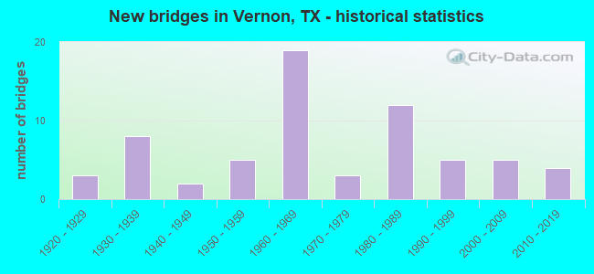
- New bridges - historical statistics
- 31920-1929
- 81930-1939
- 21940-1949
- 51950-1959
- 191960-1969
- 31970-1979
- 121980-1989
- 51990-1999
- 52000-2009
- 42010-2019
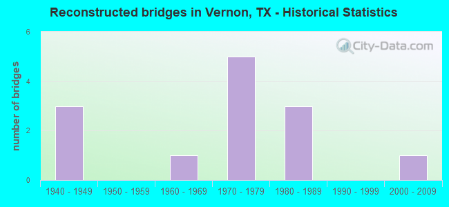
- Reconstructed bridges - Historical Statistics
- 31940-1949
- 01950-1959
- 11960-1969
- 51970-1979
- 31980-1989
- 01990-1999
- 12000-2009
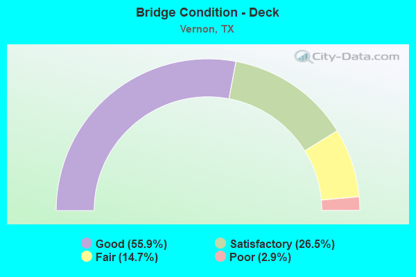
- Bridge Condition - Deck
- 55.9%Good
- 26.5%Satisfactory
- 14.7%Fair
- 2.9%Poor
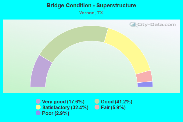
- Bridge Condition - Superstructure
- 17.6%Very good
- 41.2%Good
- 32.4%Satisfactory
- 5.9%Fair
- 2.9%Poor
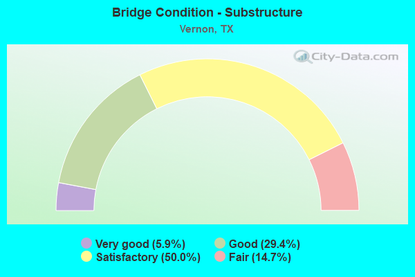
- Bridge Condition - Substructure
- 5.9%Very good
- 29.4%Good
- 50.0%Satisfactory
- 14.7%Fair
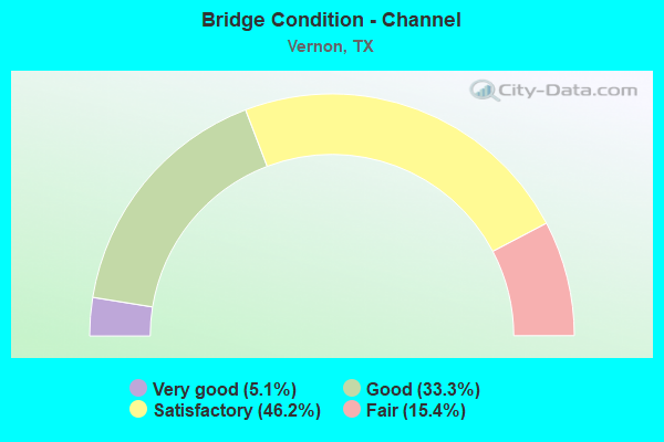
- Bridge Condition - Channel
- 5.1%Very good
- 33.3%Good
- 46.2%Satisfactory
- 15.4%Fair
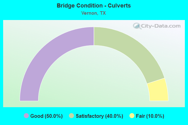
- Bridge Condition - Culverts
- 50.0%Good
- 40.0%Satisfactory
- 10.0%Fair
Find on map >> Show street view
Structure Number: 32440083202003, Location: 2.0 MI W OF US 287 (Lat: 34.183178, Lng: -99.378967), Route carried "on" structure: State highway 925, Year Built: 1930, Year Reconstructed: 1951, Status: Posted for load, Structure Length: 1.55m (5.09ft), Average Daily Traffic: 339 (year 2020), Truck Traffic: 7%, Average Future Daily Traffic: 475 (year 2040), Features Intersected: DRAW
Minimum Vertical Clearance: 30+ m (98+ ft), Kilometerpoint: 7.244, Lanes on structure: 2, Owner: State Highway Agency, Approaching Roadway Width: 5.5m (18.0ft), Material/Design: Concrete, Design/Construction: Slab, Number Of Spans In Main Unit: 1, Number Of Approach Spans: 2, Length of Maximum Span: 6.4m (21.0ft), Curb-To-Curb Width: 6.1m (20.0ft), Out-to-Out Width: 6.5m (21.3ft)
Condition: Deck: Satisfactory, Superstructure: Satisfactory, Substructure: Fair, Channel: Satisfactory, Operating Rating: 32.7 metric tons, Method Used To Determine Operating Rating: Field evaluation and documented engineering judgment, Inventory Rating: 23.6 metric tons, Method Used To Determine Inventory Rating: Field evaluation and documented engineering judgment, Structural Evaluation: Somewhat better than minimum adequacy, Deck Geometry: Meets minimum limits, Waterway Adequacy: Equal to present minimum criteria, Approach Roadway Alignment: Equal to present desirable criteria, Length Of Structure Improvement: 1.55m (5.09ft), Designated Inspection Frequency: Every 24 months, Inspection Date: November 2021, Bridge Improvement Cost: $105,000, Roadway Improvement Cost: $66,000, Total Project Cost: $171,000, Deck Structure Type: Concrete Cast-file-Place, Wearing Surface/Protective System: Wearing Surface: Bituminous
Find on map >> Show street view
Structure Number: 32440176901098, Location: 1.4 MI NE OF US 287 (Lat: 34.160356, Lng: -99.210064), Route carried "on" structure: State highway 1763, Year Built: 2017, Status: Open, Structure Length: 2.13m (6.99ft), Average Daily Traffic: 255 (year 2020), Truck Traffic: 7%, Average Future Daily Traffic: 357 (year 2040), Design Load: HL 93, Features Intersected: PLUM CREEK
Minimum Vertical Clearance: 30+ m (98+ ft), Kilometerpoint: 8.692, Lanes on structure: 2, Owner: State Highway Agency, Approaching Roadway Width: 8.8m (28.9ft), Material/Design: Prestressed concrete, Design/Construction: Stringer/Multi-beam, Number Of Spans In Main Unit: 1, Length of Maximum Span: 21.3m (69.9ft), Curb-To-Curb Width: 9.0m (29.5ft), Out-to-Out Width: 9.8m (32.2ft)
Condition: Deck: Good, Superstructure: Very good, Substructure: Very good, Channel: Good, Operating Rating: 54.4 metric tons, Method Used To Determine Operating Rating: Assigned ratings based on Load and Resistance Factor Design (LRFD) reported in metric tons, Inventory Rating: 32.7 metric tons, Method Used To Determine Inventory Rating: Assigned ratings based on Load and Resistance Factor Design (LRFD) reported in metric tons, Structural Evaluation: Equal to present desirable criteria, Deck Geometry: Equal to present minimum criteria, Waterway Adequacy: Superior to present desirable criteria, Approach Roadway Alignment: Equal to present desirable criteria, Designated Inspection Frequency: Every 24 months, Inspection Date: November 2021, Deck Structure Type: Concrete Cast-file-Place
Find on map >> Show street view
Structure Number: 32440185601003, Location: 1.1 MI E OF US 287 (Lat: 34.190489, Lng: -99.312428), Route carried "on" structure: State highway 925, Year Built: 1956, Status: Open, Structure Length: 0.67m (2.20ft), Average Daily Traffic: 169 (year 2020), Truck Traffic: 8%, Average Future Daily Traffic: 237 (year 2040), Features Intersected: DRAW
Minimum Vertical Clearance: 30+ m (98+ ft), Kilometerpoint: 2.840, Lanes on structure: 2, Owner: State Highway Agency, Approaching Roadway Width: 6.4m (21.0ft), Material/Design: Concrete, Design/Construction: Culvert, Number Of Spans In Main Unit: 2, Length of Maximum Span: 3.0m (9.8ft), Curb-To-Curb Width: 6.5m (21.3ft), Out-to-Out Width: 8.9m (29.2ft)
Condition: Channel: Good, Culverts: Satisfactory, Operating Rating: 22.7 metric tons, Method Used To Determine Operating Rating: No rating analysis performed, Inventory Rating: 17.0 metric tons, Method Used To Determine Inventory Rating: No rating analysis performed, Structural Evaluation: Somewhat better than minimum adequacy, Deck Geometry: Meets minimum limits, Waterway Adequacy: Equal to present minimum criteria, Approach Roadway Alignment: Equal to present desirable criteria, Designated Inspection Frequency: Every 24 months, Inspection Date: November 2021, Deck Structure Type: Concrete Cast-file-Place, Wearing Surface/Protective System: Wearing Surface: Bituminous
Find on map >> Show street view
Structure Number: 32440185601004, Location: 2.1 MI W OF US 283 (Lat: 34.190414, Lng: -99.309247), Route carried "on" structure: State highway 925, Year Built: 1956, Status: Open, Structure Length: 1.65m (5.41ft), Average Daily Traffic: 169 (year 2020), Truck Traffic: 8%, Average Future Daily Traffic: 237 (year 2040), Features Intersected: WILDCAT CREEK
Minimum Vertical Clearance: 30+ m (98+ ft), Kilometerpoint: 3.129, Lanes on structure: 2, Owner: State Highway Agency, Approaching Roadway Width: 5.9m (19.4ft), Material/Design: Concrete, Design/Construction: Culvert, Number Of Spans In Main Unit: 5, Length of Maximum Span: 3.0m (9.8ft), Curb-To-Curb Width: 6.2m (20.3ft), Out-to-Out Width: 8.9m (29.2ft)
Condition: Channel: Satisfactory, Culverts: Satisfactory, Operating Rating: 22.7 metric tons, Method Used To Determine Operating Rating: No rating analysis performed, Inventory Rating: 17.0 metric tons, Method Used To Determine Inventory Rating: No rating analysis performed, Structural Evaluation: Somewhat better than minimum adequacy, Deck Geometry: Meets minimum limits, Waterway Adequacy: Equal to present minimum criteria, Approach Roadway Alignment: Equal to present desirable criteria, Designated Inspection Frequency: Every 24 months, Inspection Date: November 2021, Deck Structure Type: Concrete Cast-file-Place, Wearing Surface/Protective System: Wearing Surface: Bituminous
Find on map >> Show street view
Structure Number: 32440185602168, Location: 1.3 MI NE OF US 283 (Lat: 34.188842, Lng: -99.252136), Route carried "on" structure: State highway 2072, Year Built: 2008, Status: Open, Structure Length: 1.86m (6.10ft), Average Daily Traffic: 389 (year 2020), Truck Traffic: 6%, Average Future Daily Traffic: 545 (year 2040), Design Load: HS 20, Features Intersected: DRAW
Minimum Vertical Clearance: 30+ m (98+ ft), Kilometerpoint: 2.144, Lanes on structure: 2, Owner: State Highway Agency, Approaching Roadway Width: 7.9m (25.9ft), Skew: 3 degrees, Material/Design: Concrete, Design/Construction: Culvert, Number Of Spans In Main Unit: 5, Length of Maximum Span: 3.0m (9.8ft), Curb-To-Curb Width: 8.8m (28.9ft), Out-to-Out Width: 9.5m (31.2ft)
Condition: Channel: Good, Culverts: Good, Operating Rating: 54.4 metric tons, Method Used To Determine Operating Rating: Assigned rating based on Load Factor Design (LFD) reported in metric tons, Inventory Rating: 32.7 metric tons, Method Used To Determine Inventory Rating: Assigned rating based on Load Factor Design (LFD) reported in metric tons, Structural Evaluation: Better than present minimum criteria, Deck Geometry: Equal to present minimum criteria, Waterway Adequacy: Better than present minimum criteria, Approach Roadway Alignment: Equal to present desirable criteria, Designated Inspection Frequency: Every 24 months, Inspection Date: November 2021, Deck Structure Type: Concrete Cast-file-Place, Wearing Surface/Protective System: Wearing Surface: Bituminous
Find on map >> Show street view
Structure Number: 32440AA0183001, Location: 2.00 MI S OF FM 925 (Lat: 34.149028, Lng: -99.381617), Route carried "on" structure: County highway , Year Built: 2006, Status: Open, Structure Length: 0.79m (2.59ft), Average Daily Traffic: 10 (year 2015), Truck Traffic: 1%, Average Future Daily Traffic: 20 (year 2035), Design Load: HS 20, Features Intersected: ELIZABETH CREEK, Facility Carried by Structure: CR 183/SIGN CR 93S
Minimum Vertical Clearance: 30+ m (98+ ft), Kilometerpoint: 0.483, Lanes on structure: 2, Owner: County Highway Agency, Approaching Roadway Width: 4.6m (15.1ft), Material/Design: Concrete, Design/Construction: Culvert, Number Of Spans In Main Unit: 3, Length of Maximum Span: 2.4m (7.9ft), Curb-To-Curb Width: 7.2m (23.6ft), Out-to-Out Width: 7.9m (25.9ft)
Condition: Channel: Satisfactory, Culverts: Good, Operating Rating: 54.4 metric tons, Method Used To Determine Operating Rating: Assigned rating based on Load Factor Design (LFD) reported in metric tons, Inventory Rating: 32.7 metric tons, Method Used To Determine Inventory Rating: Assigned rating based on Load Factor Design (LFD) reported in metric tons, Structural Evaluation: Better than present minimum criteria, Deck Geometry: Somewhat better than minimum adequacy, Waterway Adequacy: Better than present minimum criteria, Approach Roadway Alignment: Equal to present desirable criteria, Designated Inspection Frequency: Every 24 months, Inspection Date: November 2020, Deck Structure Type: Concrete Cast-file-Place, Wearing Surface/Protective System: Wearing Surface: Gravel
Find on map >> Show street view
Structure Number: 32440AA0198001, Location: 0.01 MI S OF FM 433 (Lat: 34.078697, Lng: -99.302081), Route carried "on" structure: County highway , Year Built: 1992, Status: Posted for load, Structure Length: 1.52m (4.99ft), Average Daily Traffic: 30 (year 2015), Truck Traffic: 1%, Average Future Daily Traffic: 60 (year 2035), Features Intersected: PARADISE CREEK, Facility Carried by Structure: CR 198/SIGN CR 97S
Minimum Vertical Clearance: 30+ m (98+ ft), Kilometerpoint: 0.161, Lanes on structure: 2, Owner: County Highway Agency, Approaching Roadway Width: 5.5m (18.0ft), Material/Design: Steel, Number Of Spans In Main Unit: 1, Length of Maximum Span: 14.0m (45.9ft), Curb-To-Curb Width: 6.6m (21.7ft), Out-to-Out Width: 6.7m (22.0ft)
Condition: Deck: Good, Superstructure: Fair, Substructure: Satisfactory, Channel: Satisfactory, Operating Rating: 23.6 metric tons, Method Used To Determine Operating Rating: Allowable Stress (AS), Inventory Rating: 13.6 metric tons, Method Used To Determine Inventory Rating: Allowable Stress (AS), Structural Evaluation: Meets minimum limits, Deck Geometry: Somewhat better than minimum adequacy, Waterway Adequacy: Better than present minimum criteria, Approach Roadway Alignment: Equal to present desirable criteria, Bridge Posting: Required (Relationship of Operating Rating to Maximum Legal Load: 20.0 - 29.9% below), Length Of Structure Improvement: 1.65m (5.41ft), Designated Inspection Frequency: Every 24 months, Inspection Date: November 2020, Bridge Improvement Cost: $110,000, Roadway Improvement Cost: $39,000, Total Project Cost: $164,000, Deck Structure Type: Concrete Cast-file-Place
Find on map >> Show street view
Structure Number: 32440AA0238001, Location: 0.35 MI W OF US 183 (Lat: 34.113133, Lng: -99.282928), Route carried "on" structure: County highway , Year Built: 1939, Status: Posted for load, Structure Length: 1.65m (5.41ft), Average Daily Traffic: 380 (year 2020), Truck Traffic: 1%, Average Future Daily Traffic: 800 (year 2035), Features Intersected: PARADISE CREEK, Facility Carried by Structure: CR 238/SIGN CR128W
Minimum Vertical Clearance: 30+ m (98+ ft), Kilometerpoint: 5.955, Lanes on structure: 2, Owner: County Highway Agency, Approaching Roadway Width: 6.1m (20.0ft), Material/Design: Concrete, Design/Construction: Culvert, Number Of Spans In Main Unit: 5, Length of Maximum Span: 3.0m (9.8ft), Curb-To-Curb Width: 7.3m (24.0ft), Out-to-Out Width: 7.9m (25.9ft)
Condition: Channel: Fair, Culverts: Fair, Operating Rating: 32.7 metric tons, Method Used To Determine Operating Rating: Field evaluation and documented engineering judgment, Inventory Rating: 24.5 metric tons, Method Used To Determine Inventory Rating: Field evaluation and documented engineering judgment, Structural Evaluation: Somewhat better than minimum adequacy, Deck Geometry: Somewhat better than minimum adequacy, Waterway Adequacy: Better than present minimum criteria, Approach Roadway Alignment: Equal to present desirable criteria, Designated Inspection Frequency: Every 24 months, Inspection Date: November 2020, Deck Structure Type: Concrete Cast-file-Place, Wearing Surface/Protective System: Wearing Surface: Bituminous
Find on map >> Show street view
Structure Number: 32440AA0245001, Location: 0.75 MI N OF CR 128 W (Lat: 34.126628, Lng: -99.273144), Route carried "on" structure: County highway , Year Built: 2005, Status: Open, Structure Length: 1.01m (3.31ft), Average Daily Traffic: 70 (year 2015), Truck Traffic: 1%, Average Future Daily Traffic: 140 (year 2035), Design Load: HL 93, Features Intersected: PARADISE CREEK, Facility Carried by Structure: CR 245/EAGLE ST
Minimum Vertical Clearance: 30+ m (98+ ft), Kilometerpoint: 2.736, Lanes on structure: 2, Owner: County Highway Agency, Approaching Roadway Width: 5.5m (18.0ft), Skew: 1 degrees, Material/Design: Concrete, Design/Construction: Culvert, Number Of Spans In Main Unit: 3, Length of Maximum Span: 3.0m (9.8ft), Curb-To-Curb Width: 7.2m (23.6ft), Out-to-Out Width: 7.9m (25.9ft)
Condition: Channel: Good, Culverts: Good, Operating Rating: 54.4 metric tons, Method Used To Determine Operating Rating: Assigned ratings based on Load and Resistance Factor Design (LRFD) reported in metric tons, Inventory Rating: 32.7 metric tons, Method Used To Determine Inventory Rating: Assigned ratings based on Load and Resistance Factor Design (LRFD) reported in metric tons, Structural Evaluation: Better than present minimum criteria, Deck Geometry: Somewhat better than minimum adequacy, Waterway Adequacy: Better than present minimum criteria, Approach Roadway Alignment: Equal to present desirable criteria, Designated Inspection Frequency: Every 24 months, Inspection Date: November 2020, Deck Structure Type: Concrete Cast-file-Place, Wearing Surface/Protective System: Wearing Surface: Bituminous
Find on map >> Show street view
Structure Number: 32440AA0247001, Location: 2.75 MI N OF FM 433 (Lat: 34.142342, Lng: -99.263800), Route carried "on" structure: County highway 247, Year Built: 2005, Status: Open, Structure Length: 1.13m (3.71ft), Average Daily Traffic: 60 (year 2015), Truck Traffic: 1%, Average Future Daily Traffic: 120 (year 2035), Design Load: HL 93, Features Intersected: PARADISE CREEK
Minimum Vertical Clearance: 30+ m (98+ ft), Kilometerpoint: 0.644, Lanes on structure: 2, Owner: County Highway Agency, Approaching Roadway Width: 4.6m (15.1ft), Skew: 3 degrees, Material/Design: Concrete, Design/Construction: Culvert, Number Of Spans In Main Unit: 3, Length of Maximum Span: 3.0m (9.8ft), Curb-To-Curb Width: 7.2m (23.6ft), Out-to-Out Width: 7.9m (25.9ft)
Condition: Channel: Satisfactory, Culverts: Good, Operating Rating: 54.4 metric tons, Method Used To Determine Operating Rating: Assigned ratings based on Load and Resistance Factor Design (LRFD) reported in metric tons, Inventory Rating: 32.7 metric tons, Method Used To Determine Inventory Rating: Assigned ratings based on Load and Resistance Factor Design (LRFD) reported in metric tons, Structural Evaluation: Better than present minimum criteria, Deck Geometry: Somewhat better than minimum adequacy, Waterway Adequacy: Better than present minimum criteria, Approach Roadway Alignment: Equal to present desirable criteria, Designated Inspection Frequency: Every 24 months, Inspection Date: November 2020, Deck Structure Type: Concrete Cast-file-Place, Wearing Surface/Protective System: Wearing Surface: Bituminous
Find on map >> Show street view
Structure Number: 32440AA0260001, Location: 0.50 MI N OF US 70 (Lat: 34.150056, Lng: -99.208394), Route carried "on" structure: County highway 260, Year Built: 2011, Status: Open, Structure Length: 1.52m (4.99ft), Average Daily Traffic: 30 (year 2015), Truck Traffic: 1%, Average Future Daily Traffic: 60 (year 2035), Design Load: HL 93, Features Intersected: DRAW
Minimum Vertical Clearance: 30+ m (98+ ft), Kilometerpoint: 0.805, Lanes on structure: 2, Owner: County Highway Agency, Approaching Roadway Width: 6.1m (20.0ft), Material/Design: Prestressed concrete, Design/Construction: Slab, Number Of Spans In Main Unit: 1, Length of Maximum Span: 15.2m (49.9ft), Curb-To-Curb Width: 7.3m (24.0ft), Out-to-Out Width: 7.9m (25.9ft)
Condition: Deck: Good, Superstructure: Very good, Substructure: Good, Channel: Good, Operating Rating: 54.4 metric tons, Method Used To Determine Operating Rating: Assigned ratings based on Load and Resistance Factor Design (LRFD) reported in metric tons, Inventory Rating: 32.7 metric tons, Method Used To Determine Inventory Rating: Assigned ratings based on Load and Resistance Factor Design (LRFD) reported in metric tons, Structural Evaluation: Better than present minimum criteria, Deck Geometry: Equal to present minimum criteria, Waterway Adequacy: Better than present minimum criteria, Approach Roadway Alignment: Equal to present desirable criteria, Designated Inspection Frequency: Every 24 months, Inspection Date: November 2020, Deck Structure Type: Concrete Precast Panels
Find on map >> Show street view
Structure Number: 32440004305167, Location: JCT US 287 & FM 925 (Lat: 34.185158, Lng: -99.330458), Route carried "under" structure: US 287, Year Built: 1976, Structure Length: 0. m, Average Daily Traffic: 13,460 (year 2013), Truck Traffic: 37%, Features Intersected: US 287, Facility Carried by Structure: FM 925
Minimum Vertical Clearance: 5.01m (16.44ft), Kilometerpoint: 31.393, Lanes on structure: 2, Lanes under structure: 4, Material/Design: Prestressed concrete continuous, Design/Construction: Stringer/Multi-beam, Length of Maximum Span: 27.4m (89.9ft)
Find on map >> Show street view
Structure Number: 32440004305173, Location: US 70/287 AT BENTLEY ST (Lat: 34.160800, Lng: -99.298600), Route carried "under" structure: City street 287, Year Built: 1987, Structure Length: 0. m, Average Daily Traffic: 2,830 (year 2010), Features Intersected: BENTLEY STREET
Minimum Vertical Clearance: 5.21m (17.09ft), Kilometerpoint: 0.000, Lanes on structure: 2, Lanes under structure: 2, Material/Design: Prestressed concrete, Design/Construction: Stringer/Multi-beam, Length of Maximum Span: 19.8m (65.0ft)
Find on map >> Show street view
Structure Number: 32440004305174, Location: US 70 AT BENTLEY ST (Lat: 34.160600, Lng: -99.298500), Route carried "under" structure: City street 287, Year Built: 1987, Structure Length: 0. m, Average Daily Traffic: 2,830 (year 2010), Features Intersected: BENTLEY ST
Minimum Vertical Clearance: 5.21m (17.09ft), Kilometerpoint: 0.000, Lanes on structure: 2, Lanes under structure: 2, Material/Design: Prestressed concrete, Design/Construction: Stringer/Multi-beam, Length of Maximum Span: 19.8m (65.0ft)
Find on map >> Show street view
Structure Number: 32440004305175, Location: AT JCT US 70/287 & US 183 (Lat: 34.159819, Lng: -99.284981), Route carried "under" structure: US 283, Year Built: 1987, Structure Length: 0. m, Average Daily Traffic: 2,800 (year 2010), Truck Traffic: 19%, Features Intersected: US 183/283, Facility Carried by Structure: US 70/287 NB
Minimum Vertical Clearance: 5.28m (17.32ft), Kilometerpoint: 3.573, Lanes on structure: 2, Lanes under structure: 6, Material/Design: Prestressed concrete, Design/Construction: Stringer/Multi-beam, Length of Maximum Span: 24.4m (80.1ft)
Find on map >> Show street view
Structure Number: 32440004305176, Location: AT JCT US 70/287 & US 183 (Lat: 34.159647, Lng: -99.284983), Route carried "under" structure: US 283, Year Built: 1987, Structure Length: 0. m, Average Daily Traffic: 2,800 (year 2010), Truck Traffic: 19%, Features Intersected: US 183/283, Facility Carried by Structure: US 70/287 SB
Minimum Vertical Clearance: 5.18m (16.99ft), Kilometerpoint: 3.573, Lanes on structure: 2, Lanes under structure: 6, Material/Design: Prestressed concrete, Design/Construction: Stringer/Multi-beam, Length of Maximum Span: 24.4m (80.1ft)
Find on map >> Show street view
Structure Number: 32440004305177, Location: US 70/287 AT LAURIE ST. (Lat: 34.158597, Lng: -99.271156), Route carried "under" structure: City street 70, Year Built: 1987, Structure Length: 0. m, Average Daily Traffic: 1,180 (year 2010), Features Intersected: LAURIE STREET
Minimum Vertical Clearance: 5.08m (16.67ft), Kilometerpoint: 0.000, Lanes on structure: 2, Lanes under structure: 2, Material/Design: Prestressed concrete, Design/Construction: Stringer/Multi-beam, Length of Maximum Span: 18.3m (60.0ft)
Find on map >> Show street view
Structure Number: 32440004305178, Location: US 70 AT LAURIE ST. (Lat: 34.158378, Lng: -99.271222), Route carried "under" structure: City street 70, Year Built: 1987, Structure Length: 0. m, Average Daily Traffic: 1,180 (year 2010), Features Intersected: LAURIE STREET
Minimum Vertical Clearance: 5.08m (16.67ft), Kilometerpoint: 0.000, Lanes on structure: 2, Lanes under structure: 2, Material/Design: Prestressed concrete, Design/Construction: Stringer/Multi-beam, Length of Maximum Span: 18.3m (60.0ft)
Find on map >> Show street view
Structure Number: 32440004306097, Location: JCT OF US 287&FM 1763 (Lat: 34.148200, Lng: -99.227100), Route carried "under" structure: US 70, Year Built: 1961, Structure Length: 0. m, Average Daily Traffic: 14,310 (year 2013), Truck Traffic: 30%, Features Intersected: US 287, Facility Carried by Structure: FM 1763
Minimum Vertical Clearance: 5.18m (16.99ft), Kilometerpoint: 29.221, Lanes on structure: 4, Material/Design: Steel continuous, Design/Construction: Stringer/Multi-beam, Length of Maximum Span: 18.3m (60.0ft)
Find on map >> Show street view
Structure Number: 3244000430611, Location: 1.9 MI E OF US 283 (Lat: 34.154669, Lng: -99.253800), Route carried "under" structure: US 70, Year Built: 1965, Structure Length: 0. m, Average Daily Traffic: 12,400 (year 2013), Truck Traffic: 30%, Features Intersected: US 70/183/287, Facility Carried by Structure: FM 1949
Minimum Vertical Clearance: 5.54m (18.18ft), Kilometerpoint: 23.897, Lanes on structure: 2, Lanes under structure: 4, Material/Design: Prestressed concrete, Design/Construction: Stringer/Multi-beam, Length of Maximum Span: 18.3m (60.0ft)
Find on map >> Show street view
Structure Number: 32440004306113, Location: 0.5 MI W OF FM 1763 (Lat: 34.149689, Lng: -99.235972), Route carried "under" structure: Business State highway 287, Year Built: 1965, Structure Length: 0. m, Average Daily Traffic: 1,050 (year 2010), Truck Traffic: 12%, Features Intersected: VERNON ACCESS
Minimum Vertical Clearance: 5.16m (16.93ft), Kilometerpoint: 28.363, Lanes on structure: 2, Material/Design: Steel continuous, Design/Construction: Stringer/Multi-beam, Length of Maximum Span: 27.4m (89.9ft)
Find on map >> Show street view
Structure Number: 32440014607131, Location: JCT US 70 AND US 287 (Lat: 34.162981, Lng: -99.312711), Route carried "under" structure: US 70, Year Built: 1969, Structure Length: 0. m, Average Daily Traffic: 3,410 (year 2010), Truck Traffic: 16%, Features Intersected: US 70, Facility Carried by Structure: US 287 NB
Minimum Vertical Clearance: 4.93m (16.17ft), Kilometerpoint: 21.610, Lanes on structure: 2, Lanes under structure: 4, Material/Design: Prestressed concrete, Design/Construction: Stringer/Multi-beam, Length of Maximum Span: 18.3m (60.0ft)
Find on map >> Show street view
Structure Number: 32440014607132, Location: 1.6 MI W OF US 183 (Lat: 34.162850, Lng: -99.312903), Route carried "under" structure: US 70, Year Built: 1969, Structure Length: 0. m, Average Daily Traffic: 3,410 (year 2010), Truck Traffic: 16%, Features Intersected: US 70, Facility Carried by Structure: US 287 SB
Minimum Vertical Clearance: 4.90m (16.08ft), Kilometerpoint: 21.610, Lanes on structure: 2, Lanes under structure: 4, Material/Design: Prestressed concrete, Design/Construction: Stringer/Multi-beam, Length of Maximum Span: 18.3m (60.0ft)