Bridge Statistics for Venice, Florida (FL)
Condition, Traffic, Stress, Structural Evaluation, Project Costs
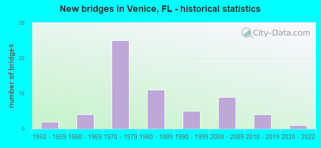
- New bridges - historical statistics
- 21950-1959
- 41960-1969
- 251970-1979
- 111980-1989
- 51990-1999
- 92000-2009
- 42010-2019
- 12020-2022
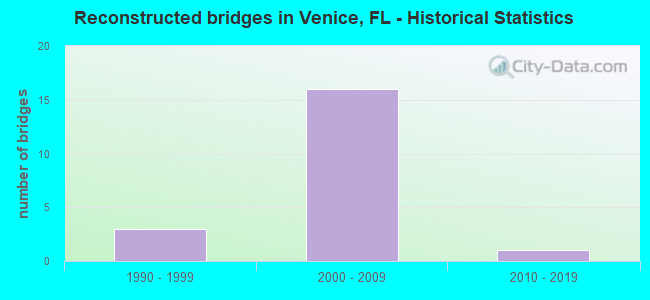
- Reconstructed bridges - Historical Statistics
- 31990-1999
- 162000-2009
- 12010-2019
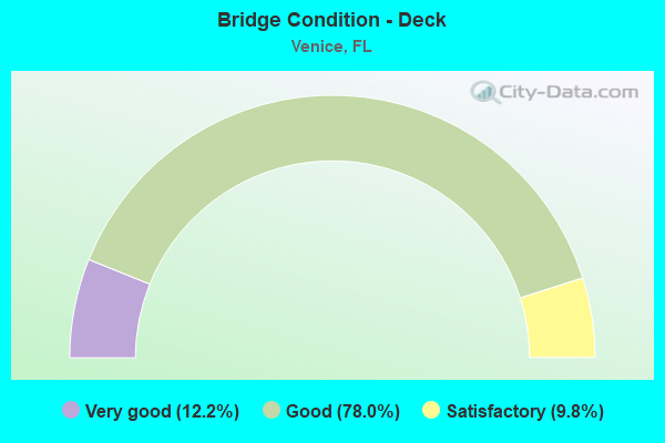
- Bridge Condition - Deck
- 12.2%Very good
- 78.0%Good
- 9.8%Satisfactory
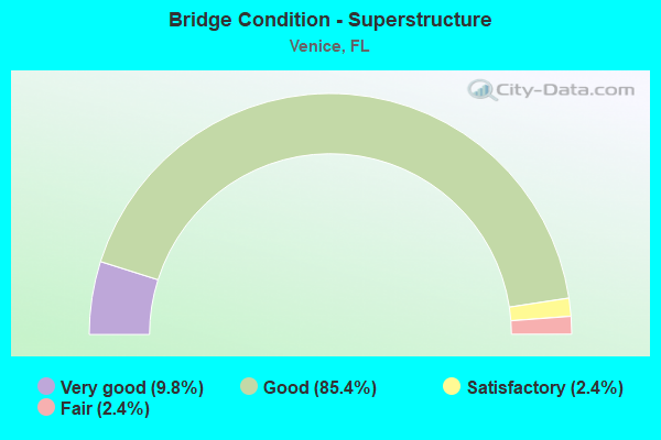
- Bridge Condition - Superstructure
- 9.8%Very good
- 85.4%Good
- 2.4%Satisfactory
- 2.4%Fair
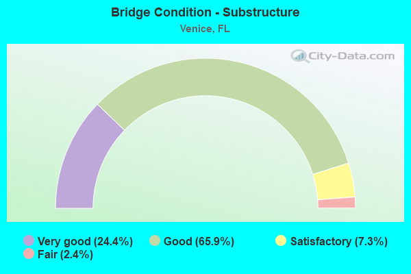
- Bridge Condition - Substructure
- 24.4%Very good
- 65.9%Good
- 7.3%Satisfactory
- 2.4%Fair
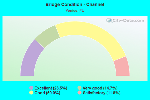
- Bridge Condition - Channel
- 23.5%Excellent
- 14.7%Very good
- 50.0%Good
- 11.8%Satisfactory
Find on map >> Show street view
Structure Number: 176002, Location: 0.1 MI N OF VENICE AVE (Lat: 27.100569, Lng: -82.427464), Route carried "on" structure: City street , Year Built: 1980, Status: Open, Structure Length: 0.91m (2.99ft), Average Daily Traffic: 1,200 (year 2020), Truck Traffic: 5%, Average Future Daily Traffic: 2,082 (year 2042), Features Intersected: HATCHETT CREEK, Facility Carried by Structure: BAY INDIES BLVD
Minimum Vertical Clearance: 30+ m (98+ ft), Kilometerpoint: 0.000, Lanes on structure: 2, Owner: City or Municipal Highway Agency, Approaching Roadway Width: 9.1m (29.9ft), Skew: 20 degrees, Material/Design: Aluminum, Iron, Design/Construction: Culvert, Number Of Spans In Main Unit: 2, Length of Maximum Span: 4.2m (13.8ft), Curb or Sidewalk Widths: Left: 2.1m (6.9ft), Right: 2.1m (6.9ft)
Condition: Channel: Good, Culverts: Good, Structural Evaluation: Better than present minimum criteria, Waterway Adequacy: Equal to present desirable criteria, Approach Roadway Alignment: Better than present minimum criteria, Designated Inspection Frequency: Every 24 months, Inspection Date: October 2020
Find on map >> Show street view
Structure Number: 176003, Location: 1.0MI NORTH OF VENICE AVE (Lat: 27.113542, Lng: -82.417258), Route carried "on" structure: City street , Year Built: 1984, Status: Open, Structure Length: 3.15m (10.33ft), Average Daily Traffic: 8,800 (year 2020), Truck Traffic: 4%, Average Future Daily Traffic: 15,268 (year 2042), Design Load: HS 20, Features Intersected: CURRY CREEK, Facility Carried by Structure: PINEBROOK RD
Minimum Vertical Clearance: 30+ m (98+ ft), Kilometerpoint: 3.859, Lanes on structure: 2, Owner: County Highway Agency, Approaching Roadway Width: 7.8m (25.6ft), Skew: 1 degrees, Material/Design: Prestressed concrete, Design/Construction: Slab, Number Of Spans In Main Unit: 3, Length of Maximum Span: 10.6m (34.8ft), Curb or Sidewalk Widths: Left: 1.7m (5.6ft), Right: 2.1m (6.9ft), Curb-To-Curb Width: 7.8m (25.6ft), Out-to-Out Width: 12.1m (39.7ft)
Condition: Deck: Good, Superstructure: Good, Substructure: Good, Channel: Good, Operating Rating: 50.0 metric tons, Method Used To Determine Operating Rating: Load Factor (LF), Inventory Rating: 31.0 metric tons, Method Used To Determine Inventory Rating: Load Factor (LF), Structural Evaluation: Better than present minimum criteria, Deck Geometry: High priority of replacement, Waterway Adequacy: Equal to present desirable criteria, Approach Roadway Alignment: Equal to present desirable criteria, Designated Inspection Frequency: Every 24 months, Underwater Inspection Frequency: Every 24 months, Inspection Date: October 2020, Underwater Inspection Date: September 2020, Deck Structure Type: Concrete Precast Panels, Wearing Surface/Protective System: Wearing Surface: Bituminous
Find on map >> Show street view
Structure Number: 176005, Location: 1.0 MI N/O VENICE AVE (Lat: 27.111417, Lng: -82.409417), Route carried "on" structure: City street , Year Built: 2020, Status: Open, Structure Length: 2.56m (8.40ft), Average Daily Traffic: 3,000 (year 2020), Truck Traffic: 2%, Average Future Daily Traffic: 5,205 (year 2040), Design Load: HL 93, Features Intersected: CURRY CREEK, Facility Carried by Structure: CAPRI ISLE BLVD
Minimum Vertical Clearance: 30+ m (98+ ft), Kilometerpoint: 0.000, Lanes on structure: 2, Owner: City or Municipal Highway Agency, Approaching Roadway Width: 8.5m (27.9ft), Skew: 1 degrees, Material/Design: Prestressed concrete, Design/Construction: Slab, Number Of Spans In Main Unit: 2, Length of Maximum Span: 12.8m (42.0ft), Curb or Sidewalk Widths: Left: 1.5m (4.9ft), Right: 1.5m (4.9ft), Curb-To-Curb Width: 9.9m (32.5ft), Out-to-Out Width: 13.7m (44.9ft)
Condition: Deck: Very good, Superstructure: Good, Substructure: Good, Channel: Very good, Operating Rating: 67.6 metric tons, Method Used To Determine Operating Rating: Load and Resistance Factor (LRFR), Inventory Rating: 45.1 metric tons, Method Used To Determine Inventory Rating: Load and Resistance Factor (LRFR), Structural Evaluation: Better than present minimum criteria, Deck Geometry: Meets minimum limits, Waterway Adequacy: Equal to present desirable criteria, Approach Roadway Alignment: Better than present minimum criteria, Designated Inspection Frequency: Every 24 months, Underwater Inspection Frequency: Every 23 months, Inspection Date: June 2020, Underwater Inspection Date: June 2020, Deck Structure Type: Concrete Cast-file-Place
Find on map >> Show street view
Structure Number: 170054, Location: 0.3MI EAST OF US-41 (Lat: 27.099831, Lng: -82.440814), Route carried "under" structure: City street , Year Built: 1966, Structure Length: 0. m, Average Daily Traffic: 200 (year 2020), Truck Traffic: 10%, Features Intersected: INTRACOASTAL WATERWAY, Facility Carried by Structure: VENICE AVE CR-772
Minimum Vertical Clearance: 4.30m (14.11ft), Kilometerpoint: 0.000, Lanes on structure: 2, Lanes under structure: 2, Material/Design: Steel, Design/Construction: Movable - Bascule, Length of Maximum Span: 44.3m (145.3ft)
Find on map >> Show street view
Structure Number: 170054, Location: 0.3MI EAST OF US-41 (Lat: 27.099831, Lng: -82.440814), Route carried "under" structure: City street , Year Built: 1966, Structure Length: 0. m, Average Daily Traffic: 225 (year 2020), Truck Traffic: 10%, Features Intersected: INTRACOASTAL WATERWAY, Facility Carried by Structure: VENICE AVE CR-772
Minimum Vertical Clearance: 4.42m (14.50ft), Kilometerpoint: 0.000, Lanes on structure: 2, Lanes under structure: 2, Material/Design: Steel, Design/Construction: Movable - Bascule, Length of Maximum Span: 44.3m (145.3ft)
Find on map >> Show street view
Structure Number: 170089, Location: 0.5MI N OF MYAKKA RIVER (Lat: 27.110333, Lng: -82.348250), Route carried "under" structure: State highway 777, Year Built: 1979, Structure Length: 0. m, Average Daily Traffic: 19,700 (year 2020), Truck Traffic: 10%, Features Intersected: NORTH RIVER ROAD, Facility Carried by Structure: I-75 (SR-93) NB
Minimum Vertical Clearance: 5.03m (16.50ft), Kilometerpoint: 8.990, Lanes on structure: 3, Lanes under structure: 4, Material/Design: Prestressed concrete, Design/Construction: Stringer/Multi-beam, Length of Maximum Span: 32.9m (107.9ft)
Find on map >> Show street view
Structure Number: 17009, Location: 0.5MI N OF MYAKKA RIVER (Lat: 27.110047, Lng: -82.348139), Route carried "under" structure: State highway 777, Year Built: 1979, Structure Length: 0. m, Average Daily Traffic: 19,700 (year 2020), Truck Traffic: 10%, Features Intersected: NORTH RIVER ROAD, Facility Carried by Structure: I-75 (SR-93) SB
Minimum Vertical Clearance: 4.91m (16.11ft), Kilometerpoint: 8.990, Lanes on structure: 3, Lanes under structure: 4, Material/Design: Prestressed concrete, Design/Construction: Stringer/Multi-beam, Length of Maximum Span: 32.9m (107.9ft)
Find on map >> Show street view
Structure Number: 170091, Location: 0.8MI N OF RIVER RD (Lat: 27.109119, Lng: -82.359986), Route carried "under" structure: County highway , Year Built: 1979, Structure Length: 0. m, Average Daily Traffic: 775 (year 2020), Truck Traffic: 14%, Features Intersected: N JACKSON RD, Facility Carried by Structure: I-75 (SR-93) SB
Minimum Vertical Clearance: 4.97m (16.31ft), Kilometerpoint: 1.078, Lanes on structure: 3, Lanes under structure: 2, Material/Design: Prestressed concrete, Design/Construction: Stringer/Multi-beam, Length of Maximum Span: 18.0m (59.1ft)
Find on map >> Show street view
Structure Number: 170092, Location: 0.8MI N OF RIVER RD (Lat: 27.109383, Lng: -82.359989), Route carried "under" structure: County highway , Year Built: 1979, Structure Length: 0. m, Average Daily Traffic: 775 (year 2020), Truck Traffic: 14%, Features Intersected: N JACKSON RD, Facility Carried by Structure: I-75 (SR-93) NB
Minimum Vertical Clearance: 4.97m (16.31ft), Kilometerpoint: 1.122, Lanes on structure: 3, Lanes under structure: 2, Material/Design: Prestressed concrete, Design/Construction: Stringer/Multi-beam, Length of Maximum Span: 18.0m (59.1ft)
Find on map >> Show street view
Structure Number: 170093, Location: 1.0MI S OF JACARANDA BLVD (Lat: 27.109144, Lng: -82.368158), Route carried "under" structure: County highway , Year Built: 1979, Structure Length: 0. m, Average Daily Traffic: 1,000 (year 2021), Truck Traffic: 5%, Features Intersected: N HAVANA RD, Facility Carried by Structure: I-75 (SR-93) SB
Minimum Vertical Clearance: 5.12m (16.80ft), Kilometerpoint: 1.096, Lanes on structure: 3, Lanes under structure: 2, Material/Design: Prestressed concrete, Design/Construction: Stringer/Multi-beam, Length of Maximum Span: 18.3m (60.0ft)
Find on map >> Show street view
Structure Number: 170094, Location: 1.0MI S OF JACARANDA BLVD (Lat: 27.109433, Lng: -82.368161), Route carried "under" structure: County highway , Year Built: 1979, Structure Length: 0. m, Average Daily Traffic: 1,000 (year 2021), Truck Traffic: 5%, Features Intersected: N. HAVANA ROAD, Facility Carried by Structure: I-75 (SR-93) NB
Minimum Vertical Clearance: 4.94m (16.21ft), Kilometerpoint: 1.127, Lanes on structure: 3, Lanes under structure: 2, Material/Design: Prestressed concrete, Design/Construction: Stringer/Multi-beam, Length of Maximum Span: 18.3m (60.0ft)
Find on map >> Show street view
Structure Number: 170095, Location: 2.5MI. S OF LAUREL RD. (Lat: 27.111306, Lng: -82.384319), Route carried "under" structure: County highway , Year Built: 1979, Structure Length: 0. m, Average Daily Traffic: 5,500 (year 2020), Truck Traffic: 8%, Features Intersected: JACARANDA BLVD, Facility Carried by Structure: I-75 (SR-93) NB
Minimum Vertical Clearance: 4.85m (15.91ft), Kilometerpoint: 0.000, Lanes on structure: 4, Lanes under structure: 6, Material/Design: Steel, Design/Construction: Stringer/Multi-beam, Length of Maximum Span: 40.5m (132.9ft)
Find on map >> Show street view
Structure Number: 170096, Location: 2.5MI S OF LAUREL RD. (Lat: 27.110997, Lng: -82.384328), Route carried "under" structure: County highway , Year Built: 1979, Structure Length: 0. m, Average Daily Traffic: 33,000 (year 2020), Truck Traffic: 4%, Features Intersected: JACARANDA BLVD, Facility Carried by Structure: I-75 (SR-93) SB
Minimum Vertical Clearance: 4.85m (15.91ft), Kilometerpoint: 8.401, Lanes on structure: 3, Lanes under structure: 6, Material/Design: Steel, Design/Construction: Stringer/Multi-beam, Length of Maximum Span: 12.5m (41.0ft)
Find on map >> Show street view
Structure Number: 170103, Location: 2.3MI W OF N JACKSON RD. (Lat: 27.122803, Lng: -82.397547), Route carried "under" structure: Interstate 75, Year Built: 1980, Structure Length: 0. m, Average Daily Traffic: 43,000 (year 2020), Truck Traffic: 11%, Features Intersected: I-75 SB (SR-93), Facility Carried by Structure: BORDER ROAD
Minimum Vertical Clearance: 4.91m (16.11ft), Kilometerpoint: 37.734, Lanes on structure: 2, Lanes under structure: 3, Material/Design: Prestressed concrete, Design/Construction: Stringer/Multi-beam, Length of Maximum Span: 35.4m (116.1ft)
Find on map >> Show street view
Structure Number: 170104, Location: 2.2MI W OF N JACKSON RD. (Lat: 27.122794, Lng: -82.395686), Route carried "under" structure: Interstate 75, Year Built: 1980, Structure Length: 0. m, Average Daily Traffic: 43,000 (year 2020), Truck Traffic: 11%, Features Intersected: I-75 NB (SR-93), Facility Carried by Structure: BORDER ROAD
Minimum Vertical Clearance: 5.00m (16.40ft), Kilometerpoint: 37.626, Lanes on structure: 2, Lanes under structure: 3, Material/Design: Prestressed concrete, Design/Construction: Stringer/Multi-beam, Length of Maximum Span: 32.6m (107.0ft)
Find on map >> Show street view
Structure Number: 170126, Location: 19.5 MI S OF SR-681 (Lat: 27.111303, Lng: -82.338425), Route carried "under" structure: Interstate 75, Year Built: 1981, Structure Length: 0. m, Average Daily Traffic: 75,905 (year 2020), Truck Traffic: 13%, Features Intersected: I-75 (SR-93), Facility Carried by Structure: SOUTH MOON DRIVE
Minimum Vertical Clearance: 4.88m (16.01ft), Kilometerpoint: 31.316, Lanes on structure: 2, Lanes under structure: 6, Material/Design: Prestressed concrete, Design/Construction: Stringer/Multi-beam, Length of Maximum Span: 33.1m (108.6ft)
Find on map >> Show street view
Structure Number: 170169, Location: 0.1MI N/O VENICE AVE (Lat: 27.103172, Lng: -82.444083), Route carried "under" structure: ServiceCity street , Year Built: 2004, Structure Length: 0. m, Average Daily Traffic: 100 (year 2020), Truck Traffic: 5%, Features Intersected: HATCHETT CREEK, Facility Carried by Structure: BUS US-41 NB
Minimum Vertical Clearance: 4.79m (15.72ft), Kilometerpoint: 0.000, Lanes on structure: 2, Lanes under structure: 1, Material/Design: Steel, Design/Construction: Movable - Bascule, Length of Maximum Span: 62.3m (204.4ft)
Find on map >> Show street view
Structure Number: 17017, Location: 0.1MI N/O VENICE AVE (Lat: 27.103281, Lng: -82.444214), Route carried "under" structure: ServiceCity street , Year Built: 2003, Structure Length: 0. m, Average Daily Traffic: 100 (year 2021), Truck Traffic: 5%, Features Intersected: HATCHETT CREEK/ICWW, Facility Carried by Structure: US-41 BUS SB
Minimum Vertical Clearance: 4.85m (15.91ft), Kilometerpoint: 0.000, Lanes on structure: 2, Lanes under structure: 1, Material/Design: Steel, Design/Construction: Movable - Bascule, Length of Maximum Span: 62.3m (204.4ft)
Find on map >> Show street view
Structure Number: 179003, Location: 0.1MI S OF US-41 (SR-45A) (Lat: 27.108528, Lng: -82.442083), Route carried "under" structure: US 41, Year Built: 2011, Structure Length: 0. m, Average Daily Traffic: 25,500 (year 2020), Truck Traffic: 5%, Features Intersected: US-41 BYPASS (SR-45A), Facility Carried by Structure: LEGACY TRAIL PED.
Minimum Vertical Clearance: 5.61m (18.41ft), Kilometerpoint: 4.670, Lanes under structure: 6, Material/Design: Prestressed concrete, Design/Construction: Stringer/Multi-beam, Length of Maximum Span: 36.0m (118.1ft)