Bridge Statistics for Venice, Florida (FL)
Condition, Traffic, Stress, Structural Evaluation, Project Costs
- New bridges - historical statistics
- 21950-1959
- 41960-1969
- 251970-1979
- 111980-1989
- 51990-1999
- 92000-2009
- 42010-2019
- 12020-2022
- Reconstructed bridges - Historical Statistics
- 31990-1999
- 162000-2009
- 12010-2019
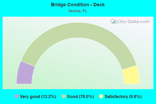
- Bridge Condition - Deck
- 12.2%Very good
- 78.0%Good
- 9.8%Satisfactory
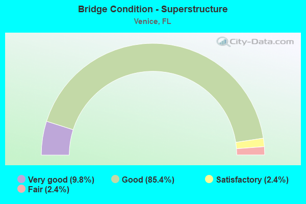
- Bridge Condition - Superstructure
- 9.8%Very good
- 85.4%Good
- 2.4%Satisfactory
- 2.4%Fair
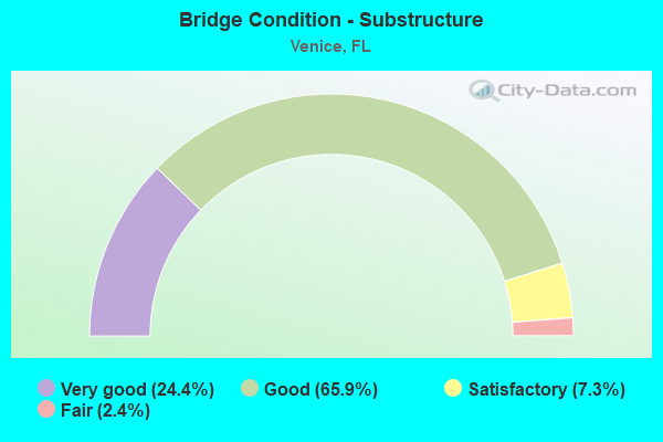
- Bridge Condition - Substructure
- 24.4%Very good
- 65.9%Good
- 7.3%Satisfactory
- 2.4%Fair
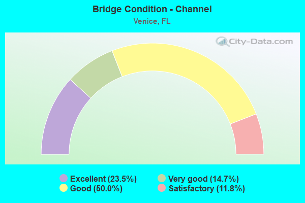
- Bridge Condition - Channel
- 23.5%Excellent
- 14.7%Very good
- 50.0%Good
- 11.8%Satisfactory
Find on map >> Show street view
Structure Number: 170054, Location: 0.3MI EAST OF US-41 (Lat: 27.099831, Lng: -82.440814), Route carried "on" structure: County highway 772, Year Built: 1966, Year Reconstructed: 2004, Status: Open, Structure Length: 35.63m (116.90ft), Average Daily Traffic: 13,200 (year 2021), Truck Traffic: 4%, Average Future Daily Traffic: 16,500 (year 2041), Design Load: HS 20, Features Intersected: INTRACOASTAL WATERWAY
Minimum Vertical Clearance: 5.79m (19.00ft), Kilometerpoint: 0.000, Lanes on structure: 2, Lanes under structure: 7, Base Highway Network: Yes, Owner: County Highway Agency, Approaching Roadway Width: 8.5m (27.9ft), Navigation Control: Yes ( Vertical Clearance: 7.7m (25.3ft), Horizontal Clearance: 27.4m (89.9ft)), Material/Design: Steel, Design/Construction: Movable - Bascule, Number Of Spans In Main Unit: 1, Number Of Approach Spans: 18, Length of Maximum Span: 44.3m (145.3ft), Curb or Sidewalk Widths: Left: 1.2m (3.9ft), Right: 1.2m (3.9ft), Curb-To-Curb Width: 8.5m (27.9ft), Out-to-Out Width: 11.5m (37.7ft)
Condition: Deck: Good, Superstructure: Satisfactory, Substructure: Good, Channel: Good, Operating Rating: 40.8 metric tons, Method Used To Determine Operating Rating: Load Factor (LF), Inventory Rating: 24.5 metric tons, Method Used To Determine Inventory Rating: Load Factor (LF), Structural Evaluation: Equal to present minimum criteria, Deck Geometry: Meets minimum limits, Underclear: Somewhat better than minimum adequacy, Waterway Adequacy: Equal to present desirable criteria, Approach Roadway Alignment: Equal to present minimum criteria, Designated Inspection Frequency: Every 24 months, Critical Feature Inspection Frequency: Every 12 months, Underwater Inspection Frequency: Every 24 months, Other Special Inspection Frequency: Every 12 months, Inspection Date: August 2021, Critical Feature Inspection Date: August 2021, Underwater Inspection Date: July 2021, Other Special Inspection Date: August 2021, Deck Structure Type: Concrete Cast-file-Place
Find on map >> Show street view
Structure Number: 170087, Location: 0.4MI S OF RIVER RD. (Lat: 27.111000, Lng: -82.342222), Route carried "on" structure: Interstate 75, Year Built: 1979, Year Reconstructed: 2004, Status: Open, Structure Length: 3.84m (12.60ft), Average Daily Traffic: 37,953 (year 2020), Truck Traffic: 13%, Average Future Daily Traffic: 65,848 (year 2042), Design Load: H 20, Features Intersected: MYAKKA RIVER RELIEF
Minimum Vertical Clearance: 30+ m (98+ ft), Kilometerpoint: 31.693, Lanes on structure: 3, Base Highway Network: Yes, Owner: State Highway Agency, Approaching Roadway Width: 17.0m (55.8ft), Material/Design: Prestressed concrete, Design/Construction: Stringer/Multi-beam, Number Of Spans In Main Unit: 3, Length of Maximum Span: 12.8m (42.0ft), Curb-To-Curb Width: 17.0m (55.8ft), Out-to-Out Width: 18.0m (59.1ft)
Condition: Deck: Good, Superstructure: Good, Substructure: Good, Channel: Good, Operating Rating: 54.2 metric tons, Method Used To Determine Operating Rating: Load Factor (LF), Inventory Rating: 32.7 metric tons, Method Used To Determine Inventory Rating: Load Factor (LF), Structural Evaluation: Better than present minimum criteria, Deck Geometry: Equal to present minimum criteria, Waterway Adequacy: Equal to present desirable criteria, Approach Roadway Alignment: Equal to present desirable criteria, Designated Inspection Frequency: Every 24 months, Inspection Date: March 2021, Deck Structure Type: Concrete Cast-file-Place
Find on map >> Show street view
Structure Number: 170088, Location: 0.4MI S OF RIVER RD. (Lat: 27.110694, Lng: -82.342167), Route carried "on" structure: Interstate 75, Year Built: 1979, Year Reconstructed: 2004, Status: Open, Structure Length: 3.84m (12.60ft), Average Daily Traffic: 37,953 (year 2020), Truck Traffic: 13%, Average Future Daily Traffic: 65,848 (year 2042), Design Load: H 20, Features Intersected: MYAKKA RIVER RELIEF
Minimum Vertical Clearance: 30+ m (98+ ft), Kilometerpoint: 31.693, Lanes on structure: 3, Base Highway Network: Yes, Owner: State Highway Agency, Approaching Roadway Width: 18.6m (61.0ft), Material/Design: Prestressed concrete, Design/Construction: Stringer/Multi-beam, Number Of Spans In Main Unit: 3, Length of Maximum Span: 12.8m (42.0ft), Curb-To-Curb Width: 18.6m (61.0ft), Out-to-Out Width: 19.6m (64.3ft)
Condition: Deck: Good, Superstructure: Good, Substructure: Good, Channel: Good, Operating Rating: 56.4 metric tons, Method Used To Determine Operating Rating: Load Factor (LF), Inventory Rating: 33.8 metric tons, Method Used To Determine Inventory Rating: Load Factor (LF), Structural Evaluation: Better than present minimum criteria, Deck Geometry: Superior to present desirable criteria, Waterway Adequacy: Equal to present desirable criteria, Approach Roadway Alignment: Equal to present desirable criteria, Designated Inspection Frequency: Every 24 months, Inspection Date: March 2021, Deck Structure Type: Concrete Cast-file-Place
Find on map >> Show street view
Structure Number: 170089, Location: 0.5MI N OF MYAKKA RIVER (Lat: 27.110333, Lng: -82.348250), Route carried "on" structure: Interstate 75, Year Built: 1979, Year Reconstructed: 2007, Status: Open, Structure Length: 6.58m (21.59ft), Average Daily Traffic: 37,953 (year 2020), Truck Traffic: 13%, Average Future Daily Traffic: 65,848 (year 2042), Design Load: HL 93, Features Intersected: NORTH RIVER ROAD
Minimum Vertical Clearance: 30+ m (98+ ft), Kilometerpoint: 32.279, Lanes on structure: 3, Lanes under structure: 4, Base Highway Network: Yes, Owner: State Highway Agency, Approaching Roadway Width: 17.0m (55.8ft), Skew: 1 degrees, Material/Design: Prestressed concrete, Design/Construction: Stringer/Multi-beam, Number Of Spans In Main Unit: 2, Length of Maximum Span: 32.9m (107.9ft), Curb-To-Curb Width: 17.0m (55.8ft), Out-to-Out Width: 18.0m (59.1ft)
Condition: Deck: Good, Superstructure: Good, Substructure: Very good, Operating Rating: 37.6 metric tons, Method Used To Determine Operating Rating: Load and Resistance Factor (LRFR), Inventory Rating: 33.3 metric tons, Method Used To Determine Inventory Rating: Load and Resistance Factor (LRFR), Structural Evaluation: Better than present minimum criteria, Deck Geometry: Equal to present minimum criteria, Underclear: Superior to present desirable criteria, Approach Roadway Alignment: Equal to present desirable criteria, Designated Inspection Frequency: Every 24 months, Inspection Date: March 2021, Deck Structure Type: Concrete Cast-file-Place
Find on map >> Show street view
Structure Number: 17009, Location: 0.5MI N OF MYAKKA RIVER (Lat: 27.110047, Lng: -82.348139), Route carried "on" structure: Interstate 75, Year Built: 1979, Year Reconstructed: 2007, Status: Open, Structure Length: 6.58m (21.59ft), Average Daily Traffic: 37,953 (year 2020), Truck Traffic: 13%, Average Future Daily Traffic: 65,848 (year 2042), Design Load: HL 93, Features Intersected: NORTH RIVER ROAD
Minimum Vertical Clearance: 30+ m (98+ ft), Kilometerpoint: 32.272, Lanes on structure: 3, Lanes under structure: 4, Base Highway Network: Yes, Owner: State Highway Agency, Approaching Roadway Width: 17.1m (56.1ft), Skew: 1 degrees, Material/Design: Prestressed concrete, Design/Construction: Stringer/Multi-beam, Number Of Spans In Main Unit: 2, Length of Maximum Span: 32.9m (107.9ft), Curb-To-Curb Width: 17.1m (56.1ft), Out-to-Out Width: 18.0m (59.1ft)
Condition: Deck: Good, Superstructure: Good, Substructure: Very good, Operating Rating: 37.6 metric tons, Method Used To Determine Operating Rating: Load and Resistance Factor (LRFR), Inventory Rating: 33.3 metric tons, Method Used To Determine Inventory Rating: Load and Resistance Factor (LRFR), Structural Evaluation: Better than present minimum criteria, Deck Geometry: Equal to present minimum criteria, Underclear: Better than present minimum criteria, Approach Roadway Alignment: Equal to present desirable criteria, Designated Inspection Frequency: Every 24 months, Inspection Date: March 2021, Deck Structure Type: Concrete Cast-file-Place
Find on map >> Show street view
Structure Number: 170091, Location: 0.8MI N OF RIVER RD (Lat: 27.109119, Lng: -82.359986), Route carried "on" structure: Interstate 75, Year Built: 1979, Year Reconstructed: 2008, Status: Open, Structure Length: 3.81m (12.50ft), Average Daily Traffic: 42,000 (year 2020), Truck Traffic: 11%, Average Future Daily Traffic: 72,870 (year 2042), Design Load: HS 20, Features Intersected: N JACKSON RD
Minimum Vertical Clearance: 30+ m (98+ ft), Kilometerpoint: 33.460, Lanes on structure: 3, Lanes under structure: 2, Base Highway Network: Yes, Owner: State Highway Agency, Approaching Roadway Width: 16.9m (55.4ft), Material/Design: Prestressed concrete, Design/Construction: Stringer/Multi-beam, Number Of Spans In Main Unit: 3, Length of Maximum Span: 18.0m (59.1ft), Curb-To-Curb Width: 16.9m (55.4ft), Out-to-Out Width: 17.9m (58.7ft)
Condition: Deck: Very good, Superstructure: Good, Substructure: Very good, Operating Rating: 57.8 metric tons, Method Used To Determine Operating Rating: Load Factor (LF), Inventory Rating: 34.7 metric tons, Method Used To Determine Inventory Rating: Load Factor (LF), Structural Evaluation: Better than present minimum criteria, Deck Geometry: Equal to present minimum criteria, Underclear: Better than present minimum criteria, Approach Roadway Alignment: Equal to present desirable criteria, Designated Inspection Frequency: Every 24 months, Inspection Date: March 2021, Deck Structure Type: Concrete Cast-file-Place
Find on map >> Show street view
Structure Number: 170092, Location: 0.8MI N OF RIVER RD (Lat: 27.109383, Lng: -82.359989), Route carried "on" structure: Interstate 75, Year Built: 1979, Year Reconstructed: 2008, Status: Open, Structure Length: 3.81m (12.50ft), Average Daily Traffic: 42,000 (year 2020), Truck Traffic: 11%, Average Future Daily Traffic: 72,870 (year 2042), Design Load: HS 20, Features Intersected: N JACKSON RD
Minimum Vertical Clearance: 30+ m (98+ ft), Kilometerpoint: 33.460, Lanes on structure: 3, Lanes under structure: 2, Base Highway Network: Yes, Owner: State Highway Agency, Approaching Roadway Width: 16.9m (55.4ft), Material/Design: Prestressed concrete, Design/Construction: Stringer/Multi-beam, Number Of Spans In Main Unit: 3, Length of Maximum Span: 18.0m (59.1ft), Curb-To-Curb Width: 16.9m (55.4ft), Out-to-Out Width: 17.9m (58.7ft)
Condition: Deck: Good, Superstructure: Good, Substructure: Very good, Operating Rating: 57.8 metric tons, Method Used To Determine Operating Rating: Load Factor (LF), Inventory Rating: 34.7 metric tons, Method Used To Determine Inventory Rating: Load Factor (LF), Structural Evaluation: Better than present minimum criteria, Deck Geometry: Equal to present minimum criteria, Underclear: Better than present minimum criteria, Approach Roadway Alignment: Equal to present desirable criteria, Designated Inspection Frequency: Every 24 months, Inspection Date: March 2021, Deck Structure Type: Concrete Cast-file-Place
Find on map >> Show street view
Structure Number: 170093, Location: 1.0MI S OF JACARANDA BLVD (Lat: 27.109144, Lng: -82.368158), Route carried "on" structure: Interstate 75, Year Built: 1979, Year Reconstructed: 2007, Status: Open, Structure Length: 3.90m (12.80ft), Average Daily Traffic: 42,000 (year 2020), Truck Traffic: 11%, Average Future Daily Traffic: 72,870 (year 2042), Design Load: HS 20, Features Intersected: N HAVANA RD
Minimum Vertical Clearance: 30+ m (98+ ft), Kilometerpoint: 34.266, Lanes on structure: 3, Lanes under structure: 2, Base Highway Network: Yes, Owner: State Highway Agency, Approaching Roadway Width: 16.9m (55.4ft), Material/Design: Prestressed concrete, Design/Construction: Stringer/Multi-beam, Number Of Spans In Main Unit: 3, Length of Maximum Span: 18.3m (60.0ft), Curb-To-Curb Width: 16.9m (55.4ft), Out-to-Out Width: 18.0m (59.1ft)
Condition: Deck: Satisfactory, Superstructure: Very good, Substructure: Very good, Operating Rating: 57.8 metric tons, Method Used To Determine Operating Rating: Load Factor (LF), Inventory Rating: 34.7 metric tons, Method Used To Determine Inventory Rating: Load Factor (LF), Structural Evaluation: Equal to present desirable criteria, Deck Geometry: Equal to present minimum criteria, Underclear: Superior to present desirable criteria, Approach Roadway Alignment: Equal to present desirable criteria, Designated Inspection Frequency: Every 24 months, Inspection Date: March 2021, Deck Structure Type: Concrete Cast-file-Place
Find on map >> Show street view
Structure Number: 170094, Location: 1.0MI S OF JACARANDA BLVD (Lat: 27.109433, Lng: -82.368161), Route carried "on" structure: Interstate 75, Year Built: 1979, Year Reconstructed: 2007, Status: Open, Structure Length: 3.90m (12.80ft), Average Daily Traffic: 42,000 (year 2020), Truck Traffic: 11%, Average Future Daily Traffic: 72,870 (year 2042), Design Load: HS 20, Features Intersected: N. HAVANA ROAD
Minimum Vertical Clearance: 30+ m (98+ ft), Kilometerpoint: 34.266, Lanes on structure: 3, Lanes under structure: 2, Base Highway Network: Yes, Owner: State Highway Agency, Approaching Roadway Width: 16.9m (55.4ft), Material/Design: Prestressed concrete, Design/Construction: Stringer/Multi-beam, Number Of Spans In Main Unit: 3, Length of Maximum Span: 18.3m (60.0ft), Curb-To-Curb Width: 16.9m (55.4ft), Out-to-Out Width: 18.0m (59.1ft)
Condition: Deck: Good, Superstructure: Good, Substructure: Very good, Operating Rating: 57.8 metric tons, Method Used To Determine Operating Rating: Load Factor (LF), Inventory Rating: 34.7 metric tons, Method Used To Determine Inventory Rating: Load Factor (LF), Structural Evaluation: Better than present minimum criteria, Deck Geometry: Equal to present minimum criteria, Underclear: Better than present minimum criteria, Approach Roadway Alignment: Equal to present desirable criteria, Designated Inspection Frequency: Every 24 months, Inspection Date: March 2021, Deck Structure Type: Concrete Cast-file-Place
Find on map >> Show street view
Structure Number: 170095, Location: 2.5MI. S OF LAUREL RD. (Lat: 27.111306, Lng: -82.384319), Route carried "on" structure: Interstate 75, Year Built: 1979, Year Reconstructed: 2008, Status: Open, Structure Length: 6.68m (21.92ft), Average Daily Traffic: 42,000 (year 2020), Truck Traffic: 11%, Average Future Daily Traffic: 72,870 (year 2042), Design Load: HL 93, Features Intersected: JACARANDA BLVD
Minimum Vertical Clearance: 30.45m (99.90ft), Kilometerpoint: 35.887, Lanes on structure: 4, Lanes under structure: 6, Base Highway Network: Yes, Owner: State Highway Agency, Approaching Roadway Width: 20.7m (67.9ft), Skew: 4 degrees, Material/Design: Steel, Design/Construction: Stringer/Multi-beam, Number Of Spans In Main Unit: 3, Length of Maximum Span: 40.5m (132.9ft), Curb-To-Curb Width: 20.7m (67.9ft), Out-to-Out Width: 21.7m (71.2ft)
Condition: Deck: Satisfactory, Superstructure: Very good, Substructure: Very good, Operating Rating: 46.4 metric tons, Method Used To Determine Operating Rating: Load and Resistance Factor (LRFR), Inventory Rating: 35.9 metric tons, Method Used To Determine Inventory Rating: Load and Resistance Factor (LRFR), Structural Evaluation: Equal to present desirable criteria, Deck Geometry: Equal to present minimum criteria, Underclear: Better than present minimum criteria, Approach Roadway Alignment: Equal to present desirable criteria, Designated Inspection Frequency: Every 24 months, Inspection Date: March 2021, Deck Structure Type: Concrete Cast-file-Place
Find on map >> Show street view
Structure Number: 170096, Location: 2.5MI S OF LAUREL RD. (Lat: 27.110997, Lng: -82.384328), Route carried "on" structure: Interstate 75, Year Built: 1979, Year Reconstructed: 2008, Status: Open, Structure Length: 6.68m (21.92ft), Average Daily Traffic: 42,000 (year 2020), Truck Traffic: 11%, Average Future Daily Traffic: 72,870 (year 2042), Design Load: HL 93, Features Intersected: JACARANDA BLVD
Minimum Vertical Clearance: 30+ m (98+ ft), Kilometerpoint: 35.869, Lanes on structure: 3, Lanes under structure: 6, Base Highway Network: Yes, Owner: State Highway Agency, Approaching Roadway Width: 17.0m (55.8ft), Skew: 4 degrees, Material/Design: Steel, Design/Construction: Stringer/Multi-beam, Number Of Spans In Main Unit: 3, Length of Maximum Span: 12.5m (41.0ft), Curb-To-Curb Width: 17.0m (55.8ft), Out-to-Out Width: 18.0m (59.1ft)
Condition: Deck: Satisfactory, Superstructure: Good, Substructure: Very good, Operating Rating: 49.6 metric tons, Method Used To Determine Operating Rating: Load and Resistance Factor (LRFR), Inventory Rating: 38.2 metric tons, Method Used To Determine Inventory Rating: Load and Resistance Factor (LRFR), Structural Evaluation: Better than present minimum criteria, Deck Geometry: Equal to present minimum criteria, Underclear: Equal to present minimum criteria, Approach Roadway Alignment: Equal to present desirable criteria, Designated Inspection Frequency: Every 24 months, Inspection Date: March 2021, Deck Structure Type: Concrete Cast-file-Place
Find on map >> Show street view
Structure Number: 170101, Location: 1.9 MI SOUTH OF LAUREL RD (Lat: 27.116556, Lng: -82.391500), Route carried "on" structure: Interstate 75, Year Built: 1980, Year Reconstructed: 2012, Status: Open, Structure Length: 3.63m (11.91ft), Average Daily Traffic: 43,000 (year 2020), Truck Traffic: 11%, Average Future Daily Traffic: 74,605 (year 2042), Design Load: HS 20, Features Intersected: CURRY CREEK
Minimum Vertical Clearance: 30+ m (98+ ft), Kilometerpoint: 36.793, Lanes on structure: 3, Base Highway Network: Yes, Owner: State Highway Agency, Approaching Roadway Width: 17.1m (56.1ft), Skew: 2 degrees, Material/Design: Prestressed concrete, Design/Construction: Stringer/Multi-beam, Number Of Spans In Main Unit: 3, Length of Maximum Span: 12.2m (40.0ft), Curb-To-Curb Width: 17.1m (56.1ft), Out-to-Out Width: 18.0m (59.1ft)
Condition: Deck: Good, Superstructure: Good, Substructure: Good, Channel: Excellent, Operating Rating: 56.8 metric tons, Method Used To Determine Operating Rating: Load Factor (LF), Inventory Rating: 33.9 metric tons, Method Used To Determine Inventory Rating: Load Factor (LF), Structural Evaluation: Better than present minimum criteria, Deck Geometry: Equal to present minimum criteria, Waterway Adequacy: Equal to present desirable criteria, Approach Roadway Alignment: Equal to present desirable criteria, Designated Inspection Frequency: Every 24 months, Inspection Date: Febuary 2022, Deck Structure Type: Concrete Cast-file-Place
Find on map >> Show street view
Structure Number: 170102, Location: 1.9 MI SOUTH OF LAUREL RD (Lat: 27.116778, Lng: -82.390806), Route carried "on" structure: Interstate 75, Year Built: 1980, Year Reconstructed: 2012, Status: Open, Structure Length: 3.48m (11.42ft), Average Daily Traffic: 43,000 (year 2020), Truck Traffic: 11%, Average Future Daily Traffic: 74,605 (year 2042), Design Load: HS 20, Features Intersected: CURRY CREEK
Minimum Vertical Clearance: 30+ m (98+ ft), Kilometerpoint: 36.785, Lanes on structure: 3, Base Highway Network: Yes, Owner: State Highway Agency, Approaching Roadway Width: 17.1m (56.1ft), Skew: 1 degrees, Material/Design: Prestressed concrete, Design/Construction: Stringer/Multi-beam, Number Of Spans In Main Unit: 3, Length of Maximum Span: 11.6m (38.1ft), Curb-To-Curb Width: 17.1m (56.1ft), Out-to-Out Width: 18.0m (59.1ft)
Condition: Deck: Good, Superstructure: Good, Substructure: Good, Channel: Excellent, Operating Rating: 54.5 metric tons, Method Used To Determine Operating Rating: Load Factor (LF), Inventory Rating: 32.7 metric tons, Method Used To Determine Inventory Rating: Load Factor (LF), Structural Evaluation: Better than present minimum criteria, Deck Geometry: Equal to present minimum criteria, Waterway Adequacy: Equal to present desirable criteria, Approach Roadway Alignment: Equal to present desirable criteria, Designated Inspection Frequency: Every 24 months, Inspection Date: Febuary 2022, Deck Structure Type: Concrete Cast-file-Place
Find on map >> Show street view
Structure Number: 170103, Location: 2.3MI W OF N JACKSON RD. (Lat: 27.122803, Lng: -82.397547), Route carried "on" structure: County highway , Year Built: 1980, Status: Open, Structure Length: 6.00m (19.69ft), Average Daily Traffic: 3,600 (year 2018), Truck Traffic: 4%, Average Future Daily Traffic: 6,246 (year 2040), Design Load: HS 20+Mod, Features Intersected: I-75 SB (SR-93), Facility Carried by Structure: BORDER ROAD
Minimum Vertical Clearance: 30+ m (98+ ft), Kilometerpoint: 0.000, Lanes on structure: 2, Lanes under structure: 3, Owner: State Highway Agency, Approaching Roadway Width: 11.8m (38.7ft), Skew: 4 degrees, Material/Design: Prestressed concrete, Design/Construction: Stringer/Multi-beam, Number Of Spans In Main Unit: 3, Length of Maximum Span: 35.4m (116.1ft), Curb-To-Curb Width: 12.1m (39.7ft), Out-to-Out Width: 13.0m (42.7ft)
Condition: Deck: Good, Superstructure: Good, Substructure: Good, Operating Rating: 61.5 metric tons, Method Used To Determine Operating Rating: Load Factor (LF), Inventory Rating: 36.8 metric tons, Method Used To Determine Inventory Rating: Load Factor (LF), Structural Evaluation: Better than present minimum criteria, Deck Geometry: Somewhat better than minimum adequacy, Underclear: Somewhat better than minimum adequacy, Approach Roadway Alignment: Equal to present desirable criteria, Designated Inspection Frequency: Every 24 months, Inspection Date: Febuary 2022, Deck Structure Type: Concrete Cast-file-Place
Find on map >> Show street view
Structure Number: 170104, Location: 2.2MI W OF N JACKSON RD. (Lat: 27.122794, Lng: -82.395686), Route carried "on" structure: County highway , Year Built: 1980, Status: Open, Structure Length: 5.55m (18.21ft), Average Daily Traffic: 3,700 (year 2020), Truck Traffic: 4%, Average Future Daily Traffic: 6,420 (year 2042), Design Load: HS 20+Mod, Features Intersected: I-75 NB (SR-93), Facility Carried by Structure: BORDER ROAD
Minimum Vertical Clearance: 30+ m (98+ ft), Kilometerpoint: 0.491, Lanes on structure: 2, Lanes under structure: 3, Owner: State Highway Agency, Approaching Roadway Width: 12.1m (39.7ft), Skew: 5 degrees, Material/Design: Prestressed concrete, Design/Construction: Stringer/Multi-beam, Number Of Spans In Main Unit: 3, Length of Maximum Span: 32.6m (107.0ft), Curb-To-Curb Width: 12.1m (39.7ft), Out-to-Out Width: 13.0m (42.7ft)
Condition: Deck: Good, Superstructure: Good, Substructure: Good, Operating Rating: 61.9 metric tons, Method Used To Determine Operating Rating: Load Factor (LF), Inventory Rating: 37.0 metric tons, Method Used To Determine Inventory Rating: Load Factor (LF), Structural Evaluation: Better than present minimum criteria, Deck Geometry: Somewhat better than minimum adequacy, Underclear: Somewhat better than minimum adequacy, Approach Roadway Alignment: Equal to present desirable criteria, Designated Inspection Frequency: Every 24 months, Inspection Date: Febuary 2022, Deck Structure Type: Concrete Cast-file-Place
Find on map >> Show street view
Structure Number: 170108, Location: 1.1 Mi N of SR-762 (Lat: 27.149250, Lng: -82.416833), Route carried "on" structure: Interstate 75, Year Built: 1979, Year Reconstructed: 2012, Status: Open, Structure Length: 10.06m (33.01ft), Average Daily Traffic: 43,000 (year 2020), Truck Traffic: 11%, Average Future Daily Traffic: 74,605 (year 2042), Design Load: HS 20, Features Intersected: SALT CREEK
Minimum Vertical Clearance: 30+ m (98+ ft), Kilometerpoint: 41.183, Lanes on structure: 3, Base Highway Network: Yes, Owner: State Highway Agency, Approaching Roadway Width: 17.1m (56.1ft), Material/Design: Prestressed concrete, Design/Construction: Stringer/Multi-beam, Number Of Spans In Main Unit: 5, Length of Maximum Span: 20.1m (65.9ft), Curb-To-Curb Width: 17.1m (56.1ft), Out-to-Out Width: 18.0m (59.1ft)
Condition: Deck: Good, Superstructure: Good, Substructure: Good, Channel: Satisfactory, Operating Rating: 54.2 metric tons, Method Used To Determine Operating Rating: Load Factor (LF), Inventory Rating: 32.7 metric tons, Method Used To Determine Inventory Rating: Load Factor (LF), Structural Evaluation: Better than present minimum criteria, Deck Geometry: Equal to present minimum criteria, Waterway Adequacy: Equal to present desirable criteria, Approach Roadway Alignment: Equal to present desirable criteria, Designated Inspection Frequency: Every 24 months, Inspection Date: December 2021, Deck Structure Type: Concrete Cast-file-Place
Find on map >> Show street view
Structure Number: 170109, Location: 2.3 MI S OF SR-681 (Lat: 27.155075, Lng: -82.423769), Route carried "on" structure: County highway , Year Built: 1979, Status: Open, Structure Length: 7.83m (25.69ft), Average Daily Traffic: 12,200 (year 2016), Truck Traffic: 3%, Average Future Daily Traffic: 21,167 (year 2036), Design Load: HS 20, Features Intersected: COW PEN SLOUGH, Facility Carried by Structure: HONORE AVE
Minimum Vertical Clearance: 30+ m (98+ ft), Kilometerpoint: 0.000, Lanes on structure: 2, Owner: County Highway Agency, Approaching Roadway Width: 9.2m (30.2ft), Skew: 3 degrees, Material/Design: Prestressed concrete, Design/Construction: Stringer/Multi-beam, Number Of Spans In Main Unit: 3, Length of Maximum Span: 26.2m (86.0ft), Curb or Sidewalk Widths: Left: 2.6m (8.5ft), Right: 0.0m, Curb-To-Curb Width: 9.2m (30.2ft), Out-to-Out Width: 13.0m (42.7ft)
Condition: Deck: Good, Superstructure: Good, Substructure: Good, Channel: Very good, Operating Rating: 62.1 metric tons, Method Used To Determine Operating Rating: Load Factor (LF), Inventory Rating: 25.8 metric tons, Method Used To Determine Inventory Rating: Load Factor (LF), Structural Evaluation: Equal to present minimum criteria, Deck Geometry: Meets minimum limits, Waterway Adequacy: Equal to present desirable criteria, Approach Roadway Alignment: Equal to present desirable criteria, Designated Inspection Frequency: Every 24 months, Underwater Inspection Frequency: Every 24 months, Inspection Date: Febuary 2020, Underwater Inspection Date: January 2020, Deck Structure Type: Concrete Cast-file-Place
Find on map >> Show street view
Structure Number: 17011, Location: 2.5 MI S OF SR-681 (Lat: 27.156156, Lng: -82.423386), Route carried "on" structure: Interstate 75, Year Built: 1979, Year Reconstructed: 2012, Status: Open, Structure Length: 7.15m (23.46ft), Average Daily Traffic: 42,250 (year 2020), Truck Traffic: 12%, Average Future Daily Traffic: 73,304 (year 2042), Design Load: HS 20, Features Intersected: COW PEN SLOUGH
Minimum Vertical Clearance: 30+ m (98+ ft), Kilometerpoint: 42.194, Lanes on structure: 3, Base Highway Network: Yes, Owner: State Highway Agency, Approaching Roadway Width: 17.1m (56.1ft), Skew: 3 degrees, Material/Design: Prestressed concrete, Design/Construction: Stringer/Multi-beam, Number Of Spans In Main Unit: 3, Length of Maximum Span: 23.8m (78.1ft), Curb-To-Curb Width: 17.1m (56.1ft), Out-to-Out Width: 18.0m (59.1ft)
Condition: Deck: Good, Superstructure: Good, Substructure: Good, Channel: Good, Operating Rating: 62.7 metric tons, Method Used To Determine Operating Rating: Load Factor (LF), Inventory Rating: 37.6 metric tons, Method Used To Determine Inventory Rating: Load Factor (LF), Structural Evaluation: Better than present minimum criteria, Deck Geometry: Equal to present minimum criteria, Waterway Adequacy: Equal to present desirable criteria, Approach Roadway Alignment: Equal to present desirable criteria, Designated Inspection Frequency: Every 24 months, Underwater Inspection Frequency: Every 24 months, Inspection Date: Febuary 2020, Underwater Inspection Date: January 2020, Deck Structure Type: Concrete Cast-file-Place
Find on map >> Show street view
Structure Number: 170111, Location: 2.0 MI S OF SR-681 (Lat: 27.163292, Lng: -82.429511), Route carried "on" structure: Interstate 75, Year Built: 1979, Year Reconstructed: 2012, Status: Open, Structure Length: 3.04m (9.97ft), Average Daily Traffic: 42,250 (year 2020), Truck Traffic: 12%, Average Future Daily Traffic: 73,304 (year 2042), Design Load: HL 93, Features Intersected: FOX CREEK
Minimum Vertical Clearance: 30+ m (98+ ft), Kilometerpoint: 43.201, Lanes on structure: 3, Base Highway Network: Yes, Owner: State Highway Agency, Approaching Roadway Width: 17.1m (56.1ft), Skew: 4 degrees, Material/Design: Prestressed concrete, Design/Construction: Stringer/Multi-beam, Number Of Spans In Main Unit: 2, Length of Maximum Span: 15.2m (49.9ft), Curb-To-Curb Width: 17.1m (56.1ft), Out-to-Out Width: 18.0m (59.1ft)
Condition: Deck: Good, Superstructure: Good, Substructure: Good, Channel: Good, Operating Rating: 61.1 metric tons, Method Used To Determine Operating Rating: Load and Resistance Factor (LRFR), Inventory Rating: 47.0 metric tons, Method Used To Determine Inventory Rating: Load and Resistance Factor (LRFR), Structural Evaluation: Better than present minimum criteria, Deck Geometry: Equal to present minimum criteria, Waterway Adequacy: Better than present minimum criteria, Approach Roadway Alignment: Equal to present desirable criteria, Designated Inspection Frequency: Every 24 months, Inspection Date: Febuary 2022, Deck Structure Type: Concrete Cast-file-Place
Find on map >> Show street view
Structure Number: 170112, Location: 2.0 MI S OF SR-681 (Lat: 27.163861, Lng: -82.429375), Route carried "on" structure: Interstate 75, Year Built: 1979, Year Reconstructed: 2012, Status: Open, Structure Length: 3.17m (10.40ft), Average Daily Traffic: 42,250 (year 2020), Truck Traffic: 12%, Average Future Daily Traffic: 73,304 (year 2042), Design Load: HL 93, Features Intersected: FOX CREEK
Minimum Vertical Clearance: 30+ m (98+ ft), Kilometerpoint: 43.248, Lanes on structure: 3, Base Highway Network: Yes, Owner: State Highway Agency, Approaching Roadway Width: 17.1m (56.1ft), Skew: 4 degrees, Material/Design: Prestressed concrete, Design/Construction: Stringer/Multi-beam, Number Of Spans In Main Unit: 2, Length of Maximum Span: 15.8m (51.8ft), Curb-To-Curb Width: 17.1m (56.1ft), Out-to-Out Width: 18.0m (59.1ft)
Condition: Deck: Good, Superstructure: Good, Substructure: Good, Channel: Good, Operating Rating: 57.2 metric tons, Method Used To Determine Operating Rating: Load and Resistance Factor (LRFR), Inventory Rating: 44.1 metric tons, Method Used To Determine Inventory Rating: Load and Resistance Factor (LRFR), Structural Evaluation: Better than present minimum criteria, Deck Geometry: Equal to present minimum criteria, Waterway Adequacy: Equal to present desirable criteria, Approach Roadway Alignment: Equal to present desirable criteria, Designated Inspection Frequency: Every 24 months, Inspection Date: Febuary 2022, Deck Structure Type: Concrete Cast-file-Place
Find on map >> Show street view
Structure Number: 170126, Location: 19.5 MI S OF SR-681 (Lat: 27.111303, Lng: -82.338425), Route carried "on" structure: County highway , Year Built: 1981, Status: Open, Structure Length: 8.62m (28.28ft), Average Daily Traffic: 400 (year 2021), Truck Traffic: 5%, Average Future Daily Traffic: 694 (year 2042), Design Load: HS 20+Mod, Features Intersected: I-75 (SR-93), Facility Carried by Structure: SOUTH MOON DRIVE
Minimum Vertical Clearance: 30.45m (99.90ft), Kilometerpoint: 0.204, Lanes on structure: 2, Lanes under structure: 6, Owner: State Highway Agency, Approaching Roadway Width: 12.1m (39.7ft), Skew: 2 degrees, Material/Design: Prestressed concrete, Design/Construction: Stringer/Multi-beam, Number Of Spans In Main Unit: 4, Length of Maximum Span: 33.1m (108.6ft), Curb-To-Curb Width: 12.1m (39.7ft), Out-to-Out Width: 13.0m (42.7ft)
Condition: Deck: Good, Superstructure: Good, Substructure: Good, Operating Rating: 59.0 metric tons, Method Used To Determine Operating Rating: Allowable Stress (AS), Inventory Rating: 50.8 metric tons, Method Used To Determine Inventory Rating: Allowable Stress (AS), Structural Evaluation: Better than present minimum criteria, Deck Geometry: Superior to present desirable criteria, Underclear: Somewhat better than minimum adequacy, Approach Roadway Alignment: Equal to present desirable criteria, Designated Inspection Frequency: Every 24 months, Inspection Date: January 2021, Deck Structure Type: Concrete Cast-file-Place
Find on map >> Show street view
Structure Number: 170127, Location: 0.5MI E OF SR-777 (Lat: 27.111017, Lng: -82.339289), Route carried "on" structure: Interstate 75, Year Built: 1979, Year Reconstructed: 2006, Status: Open, Structure Length: 15.24m (50.00ft), Average Daily Traffic: 37,953 (year 2020), Truck Traffic: 13%, Average Future Daily Traffic: 65,848 (year 2042), Design Load: HS 20, Features Intersected: MYAKKA RIVER
Minimum Vertical Clearance: 30.45m (99.90ft), Kilometerpoint: 31.369, Lanes on structure: 3, Base Highway Network: Yes, Owner: State Highway Agency, Approaching Roadway Width: 17.4m (57.1ft), Skew: 2 degrees, Material/Design: Prestressed concrete, Design/Construction: Stringer/Multi-beam, Number Of Spans In Main Unit: 10, Length of Maximum Span: 15.4m (50.5ft), Curb-To-Curb Width: 17.4m (57.1ft), Out-to-Out Width: 18.4m (60.4ft)
Condition: Deck: Good, Superstructure: Good, Substructure: Satisfactory, Channel: Good, Operating Rating: 55.1 metric tons, Method Used To Determine Operating Rating: Load Factor (LF), Inventory Rating: 33.0 metric tons, Method Used To Determine Inventory Rating: Load Factor (LF), Structural Evaluation: Equal to present minimum criteria, Deck Geometry: Better than present minimum criteria, Waterway Adequacy: Superior to present desirable criteria, Approach Roadway Alignment: Equal to present desirable criteria, Designated Inspection Frequency: Every 24 months, Underwater Inspection Frequency: Every 24 months, Inspection Date: March 2021, Underwater Inspection Date: Febuary 2021, Deck Structure Type: Concrete Cast-file-Place
Find on map >> Show street view
Structure Number: 170128, Location: 0.5MI E OF SR-777 (Lat: 27.111278, Lng: -82.339456), Route carried "on" structure: Interstate 75, Year Built: 1979, Year Reconstructed: 2006, Status: Open, Structure Length: 15.24m (50.00ft), Average Daily Traffic: 37,953 (year 2020), Truck Traffic: 13%, Average Future Daily Traffic: 65,848 (year 2042), Design Load: HS 20, Features Intersected: MYAKKA RIVER
Minimum Vertical Clearance: 30.45m (99.90ft), Kilometerpoint: 31.385, Lanes on structure: 3, Base Highway Network: Yes, Owner: State Highway Agency, Approaching Roadway Width: 17.4m (57.1ft), Skew: 2 degrees, Material/Design: Prestressed concrete, Design/Construction: Stringer/Multi-beam, Number Of Spans In Main Unit: 10, Length of Maximum Span: 15.4m (50.5ft), Curb-To-Curb Width: 17.4m (57.1ft), Out-to-Out Width: 18.4m (60.4ft)
Condition: Deck: Good, Superstructure: Good, Substructure: Satisfactory, Channel: Good, Operating Rating: 55.1 metric tons, Method Used To Determine Operating Rating: Load Factor (LF), Inventory Rating: 33.0 metric tons, Method Used To Determine Inventory Rating: Load Factor (LF), Structural Evaluation: Equal to present minimum criteria, Deck Geometry: Better than present minimum criteria, Waterway Adequacy: Superior to present desirable criteria, Approach Roadway Alignment: Equal to present desirable criteria, Designated Inspection Frequency: Every 24 months, Underwater Inspection Frequency: Every 24 months, Inspection Date: March 2021, Underwater Inspection Date: Febuary 2021, Deck Structure Type: Concrete Cast-file-Place
Find on map >> Show street view
Structure Number: 170167, Location: 0.4MI NW OF US 41 JCT. (Lat: 27.078719, Lng: -82.430292), Route carried "on" structure: Business US 41B, Year Built: 2004, Status: Open, Structure Length: 12.62m (41.40ft), Average Daily Traffic: 24,000 (year 2022), Truck Traffic: 2%, Average Future Daily Traffic: 30,000 (year 2042), Design Load: HS 20, Features Intersected: I.C.W.W., Facility Carried by Structure: BUS. 41 NB
Minimum Vertical Clearance: 5.61m (18.41ft), Kilometerpoint: 24.599, Lanes on structure: 2, Base Highway Network: Yes, Owner: State Highway Agency, Approaching Roadway Width: 9.4m (30.8ft), Navigation Control: Yes ( Vertical Clearance: 5.9m (19.4ft), Horizontal Clearance: 13.7m (44.9ft)), Material/Design: Steel, Design/Construction: Movable - Bascule, Number Of Spans In Main Unit: 1, Number Of Approach Spans: 6, Length of Maximum Span: 36.0m (118.1ft), Curb or Sidewalk Widths: Left: 0.0m, Right: 2.6m (8.5ft), Curb-To-Curb Width: 9.6m (31.5ft), Out-to-Out Width: 13.1m (43.0ft)
Condition: Deck: Good, Superstructure: Good, Substructure: Good, Channel: Very good, Operating Rating: 52.1 metric tons, Method Used To Determine Operating Rating: Load Factor (LF), Inventory Rating: 32.7 metric tons, Method Used To Determine Inventory Rating: Load Factor (LF), Structural Evaluation: Better than present minimum criteria, Deck Geometry: Meets minimum limits, Waterway Adequacy: Superior to present desirable criteria, Approach Roadway Alignment: Equal to present desirable criteria, Designated Inspection Frequency: Every 24 months, Critical Feature Inspection Frequency: Every 12 months, Underwater Inspection Frequency: Every 24 months, Other Special Inspection Frequency: Every 12 months, Inspection Date: Febuary 2021, Critical Feature Inspection Date: Febuary 2021, Underwater Inspection Date: January 2021, Other Special Inspection Date: Febuary 2021, Deck Structure Type: Concrete Cast-file-Place, Wearing Surface/Protective System: Wearing Surface: Monolithic Concrete
Find on map >> Show street view
Structure Number: 170168, Location: 0.4MI NW OF US 41 JUNCT. (Lat: 27.078578, Lng: -82.430286), Route carried "on" structure: Business US 41B, Year Built: 2004, Year Reconstructed: 2017, Status: Open, Structure Length: 12.13m (39.80ft), Average Daily Traffic: 24,000 (year 2022), Truck Traffic: 2%, Average Future Daily Traffic: 30,000 (year 2042), Design Load: HS 20, Features Intersected: I.C.W.W., Facility Carried by Structure: BUS. 41 SB
Minimum Vertical Clearance: 5.97m (19.59ft), Kilometerpoint: 24.596, Lanes on structure: 2, Base Highway Network: Yes, Owner: State Highway Agency, Approaching Roadway Width: 9.4m (30.8ft), Navigation Control: Yes ( Vertical Clearance: 5.9m (19.4ft), Horizontal Clearance: 13.7m (44.9ft)), Material/Design: Steel, Design/Construction: Movable - Bascule, Number Of Spans In Main Unit: 1, Number Of Approach Spans: 6, Length of Maximum Span: 36.0m (118.1ft), Curb or Sidewalk Widths: Left: 2.6m (8.5ft), Right: 0.0m, Curb-To-Curb Width: 9.6m (31.5ft), Out-to-Out Width: 13.0m (42.7ft)
Condition: Deck: Good, Superstructure: Good, Substructure: Good, Channel: Very good, Operating Rating: 52.1 metric tons, Method Used To Determine Operating Rating: Load Factor (LF), Inventory Rating: 32.7 metric tons, Method Used To Determine Inventory Rating: Load Factor (LF), Structural Evaluation: Better than present minimum criteria, Deck Geometry: Meets minimum limits, Waterway Adequacy: Superior to present desirable criteria, Approach Roadway Alignment: Equal to present desirable criteria, Designated Inspection Frequency: Every 24 months, Critical Feature Inspection Frequency: Every 12 months, Underwater Inspection Frequency: Every 24 months, Other Special Inspection Frequency: Every 12 months, Inspection Date: Febuary 2021, Critical Feature Inspection Date: Febuary 2022, Underwater Inspection Date: January 2021, Other Special Inspection Date: Febuary 2022, Deck Structure Type: Concrete Cast-file-Place, Wearing Surface/Protective System: Wearing Surface: Monolithic Concrete
Find on map >> Show street view
Structure Number: 170169, Location: 0.1MI N/O VENICE AVE (Lat: 27.103172, Lng: -82.444083), Route carried "on" structure: Business US 41B, Year Built: 2004, Status: Open, Structure Length: 32.92m (108.01ft), Average Daily Traffic: 7,800 (year 2021), Truck Traffic: 4%, Average Future Daily Traffic: 13,533 (year 2042), Design Load: HS 20, Features Intersected: HATCHETT CREEK, Facility Carried by Structure: BUS US-41 NB
Minimum Vertical Clearance: 5.61m (18.41ft), Kilometerpoint: 0.237, Lanes on structure: 2, Lanes under structure: 1, Base Highway Network: Yes, Owner: State Highway Agency, Approaching Roadway Width: 9.5m (31.2ft), Skew: 9 degrees, Navigation Control: Yes ( Vertical Clearance: 9.2m (30.2ft), Horizontal Clearance: 30.5m (100.1ft)), Material/Design: Steel, Design/Construction: Movable - Bascule, Number Of Spans In Main Unit: 1, Number Of Approach Spans: 17, Length of Maximum Span: 62.3m (204.4ft), Curb or Sidewalk Widths: Left: 0.0m, Right: 2.6m (8.5ft), Curb-To-Curb Width: 9.5m (31.2ft), Out-to-Out Width: 13.1m (43.0ft)
Condition: Deck: Good, Superstructure: Good, Substructure: Good, Channel: Good, Operating Rating: 59.1 metric tons, Method Used To Determine Operating Rating: Load Factor (LF), Inventory Rating: 35.4 metric tons, Method Used To Determine Inventory Rating: Load Factor (LF), Structural Evaluation: Better than present minimum criteria, Deck Geometry: Meets minimum limits, Underclear: High priority of corrective action, Waterway Adequacy: Superior to present desirable criteria, Approach Roadway Alignment: Equal to present desirable criteria, Designated Inspection Frequency: Every 24 months, Critical Feature Inspection Frequency: Every 12 months, Underwater Inspection Frequency: Every 24 months, Other Special Inspection Frequency: Every 12 months, Inspection Date: June 2021, Critical Feature Inspection Date: June 2021, Underwater Inspection Date: May 2021, Other Special Inspection Date: June 2021, Deck Structure Type: Concrete Cast-file-Place
Find on map >> Show street view
Structure Number: 17017, Location: 0.1MI N/O VENICE AVE (Lat: 27.103281, Lng: -82.444214), Route carried "on" structure: Business US 41B, Year Built: 2003, Status: Open, Structure Length: 32.92m (108.01ft), Average Daily Traffic: 7,800 (year 2021), Truck Traffic: 4%, Average Future Daily Traffic: 13,533 (year 2041), Design Load: HS 20, Features Intersected: HATCHETT CREEK/ICWW, Facility Carried by Structure: US-41 BUS SB
Minimum Vertical Clearance: 5.79m (19.00ft), Kilometerpoint: 0.237, Lanes on structure: 2, Lanes under structure: 1, Base Highway Network: Yes, Owner: State Highway Agency, Approaching Roadway Width: 9.5m (31.2ft), Skew: 9 degrees, Navigation Control: Yes ( Vertical Clearance: 9.2m (30.2ft), Horizontal Clearance: 30.5m (100.1ft)), Material/Design: Steel, Design/Construction: Movable - Bascule, Number Of Spans In Main Unit: 1, Number Of Approach Spans: 17, Length of Maximum Span: 62.3m (204.4ft), Curb or Sidewalk Widths: Left: 2.6m (8.5ft), Right: 0.0m, Curb-To-Curb Width: 9.5m (31.2ft), Out-to-Out Width: 13.1m (43.0ft)
Condition: Deck: Good, Superstructure: Good, Substructure: Good, Channel: Good, Operating Rating: 59.1 metric tons, Method Used To Determine Operating Rating: Load Factor (LF), Inventory Rating: 35.4 metric tons, Method Used To Determine Inventory Rating: Load Factor (LF), Structural Evaluation: Better than present minimum criteria, Deck Geometry: Meets minimum limits, Underclear: High priority of corrective action, Waterway Adequacy: Superior to present desirable criteria, Approach Roadway Alignment: Equal to present desirable criteria, Designated Inspection Frequency: Every 24 months, Critical Feature Inspection Frequency: Every 12 months, Underwater Inspection Frequency: Every 24 months, Other Special Inspection Frequency: Every 12 months, Inspection Date: June 2021, Critical Feature Inspection Date: June 2021, Underwater Inspection Date: May 2021, Other Special Inspection Date: June 2021, Deck Structure Type: Concrete Cast-file-Place
Find on map >> Show street view
Structure Number: 170171, Location: 0.8 MI. N OF US BUS 41 (Lat: 27.118536, Lng: -82.451247), Route carried "on" structure: US 41, Year Built: 2008, Status: Open, Structure Length: 3.45m (11.32ft), Average Daily Traffic: 37,500 (year 2020), Truck Traffic: 6%, Average Future Daily Traffic: 65,062 (year 2042), Design Load: HS 20+Mod, Features Intersected: DONA BAY
Minimum Vertical Clearance: 30.45m (99.90ft), Kilometerpoint: 2.280, Lanes on structure: 6, Base Highway Network: Yes, Owner: State Highway Agency, Approaching Roadway Width: 25.0m (82.0ft), Skew: 20 degrees, Material/Design: Concrete continuous, Design/Construction: Slab, Number Of Spans In Main Unit: 3, Length of Maximum Span: 11.5m (37.7ft), Curb or Sidewalk Widths: Left: 2.3m (7.5ft), Right: 2.3m (7.5ft), Curb-To-Curb Width: 30.4m (99.7ft), Out-to-Out Width: 39.5m (129.6ft)
Condition: Deck: Good, Superstructure: Good, Substructure: Good, Channel: Very good, Operating Rating: 77.8 metric tons, Method Used To Determine Operating Rating: Load Factor (LF), Inventory Rating: 46.7 metric tons, Method Used To Determine Inventory Rating: Load Factor (LF), Structural Evaluation: Better than present minimum criteria, Deck Geometry: Superior to present desirable criteria, Waterway Adequacy: Superior to present desirable criteria, Approach Roadway Alignment: Equal to present desirable criteria, Designated Inspection Frequency: Every 24 months, Underwater Inspection Frequency: Every 24 months, Inspection Date: January 2021, Underwater Inspection Date: December 2020, Deck Structure Type: Concrete Cast-file-Place
Find on map >> Show street view
Structure Number: 170172, Location: 1.0 MI N OF BUS US 41 (Lat: 27.119772, Lng: -82.452111), Route carried "on" structure: US 41, Year Built: 2008, Status: Open, Structure Length: 3.44m (11.29ft), Average Daily Traffic: 37,500 (year 2020), Truck Traffic: 6%, Average Future Daily Traffic: 65,062 (year 2042), Design Load: HS 20+Mod, Features Intersected: SHAKETT CREEK
Minimum Vertical Clearance: 30.45m (99.90ft), Kilometerpoint: 2.435, Lanes on structure: 6, Base Highway Network: Yes, Owner: State Highway Agency, Approaching Roadway Width: 25.3m (83.0ft), Material/Design: Prestressed concrete, Design/Construction: Stringer/Multi-beam, Number Of Spans In Main Unit: 3, Length of Maximum Span: 11.5m (37.7ft), Curb or Sidewalk Widths: Left: 2.3m (7.5ft), Right: 2.3m (7.5ft), Curb-To-Curb Width: 30.4m (99.7ft), Out-to-Out Width: 39.3m (128.9ft)
Condition: Deck: Satisfactory, Superstructure: Good, Substructure: Good, Channel: Excellent, Operating Rating: 57.2 metric tons, Method Used To Determine Operating Rating: Load Factor (LF), Inventory Rating: 35.7 metric tons, Method Used To Determine Inventory Rating: Load Factor (LF), Structural Evaluation: Better than present minimum criteria, Deck Geometry: Superior to present desirable criteria, Waterway Adequacy: Superior to present desirable criteria, Approach Roadway Alignment: Equal to present desirable criteria, Designated Inspection Frequency: Every 24 months, Underwater Inspection Frequency: Every 24 months, Inspection Date: January 2021, Underwater Inspection Date: December 2020, Deck Structure Type: Concrete Cast-file-Place
Find on map >> Show street view
Structure Number: 170177, Location: 3.3 MI S OF SR-681 (Lat: 27.147697, Lng: -82.417917), Route carried "on" structure: Interstate 75, Year Built: 2012, Status: Open, Structure Length: 10.09m (33.10ft), Average Daily Traffic: 42,250 (year 2020), Truck Traffic: 12%, Average Future Daily Traffic: 73,304 (year 2042), Design Load: HL 93, Features Intersected: SALT CREEK
Minimum Vertical Clearance: 30+ m (98+ ft), Kilometerpoint: 41.132, Lanes on structure: 3, Base Highway Network: Yes, Owner: State Highway Agency, Approaching Roadway Width: 17.1m (56.1ft), Material/Design: Prestressed concrete, Design/Construction: Stringer/Multi-beam, Number Of Spans In Main Unit: 4, Length of Maximum Span: 30.5m (100.1ft), Curb-To-Curb Width: 17.1m (56.1ft), Out-to-Out Width: 18.0m (59.1ft)
Condition: Deck: Very good, Superstructure: Very good, Substructure: Very good, Channel: Satisfactory, Operating Rating: 37.9 metric tons, Method Used To Determine Operating Rating: Load and Resistance Factor (LRFR), Inventory Rating: 33.9 metric tons, Method Used To Determine Inventory Rating: Load and Resistance Factor (LRFR), Structural Evaluation: Equal to present desirable criteria, Deck Geometry: Equal to present minimum criteria, Waterway Adequacy: Superior to present desirable criteria, Approach Roadway Alignment: Equal to present desirable criteria, Designated Inspection Frequency: Every 24 months, Inspection Date: May 2020, Deck Structure Type: Concrete Cast-file-Place
Find on map >> Show street view
Structure Number: 170178, Location: 2.5MI S OF SR-681 (Lat: 27.155664, Lng: -82.423636), Route carried "on" structure: Interstate 75, Year Built: 2012, Status: Open, Structure Length: 7.77m (25.49ft), Average Daily Traffic: 42,250 (year 2020), Truck Traffic: 12%, Average Future Daily Traffic: 73,304 (year 2042), Design Load: HL 93, Features Intersected: COWPEN SLOUGH
Minimum Vertical Clearance: 30+ m (98+ ft), Kilometerpoint: 42.158, Lanes on structure: 3, Base Highway Network: Yes, Owner: State Highway Agency, Approaching Roadway Width: 17.1m (56.1ft), Skew: 2 degrees, Material/Design: Prestressed concrete, Design/Construction: Stringer/Multi-beam, Number Of Spans In Main Unit: 3, Length of Maximum Span: 25.9m (85.0ft), Curb-To-Curb Width: 17.1m (56.1ft), Out-to-Out Width: 18.0m (59.1ft)
Condition: Deck: Very good, Superstructure: Good, Substructure: Good, Channel: Good, Operating Rating: 37.2 metric tons, Method Used To Determine Operating Rating: Load and Resistance Factor (LRFR), Inventory Rating: 33.7 metric tons, Method Used To Determine Inventory Rating: Load and Resistance Factor (LRFR), Structural Evaluation: Better than present minimum criteria, Deck Geometry: Equal to present minimum criteria, Waterway Adequacy: Meets minimum limits, Approach Roadway Alignment: Equal to present desirable criteria, Designated Inspection Frequency: Every 24 months, Underwater Inspection Frequency: Every 23 months, Inspection Date: May 2020, Underwater Inspection Date: May 2020, Deck Structure Type: Concrete Cast-file-Place
Find on map >> Show street view
Structure Number: 174019, Location: 1.2MI S OF VENICE AVE. W (Lat: 27.082150, Lng: -82.450217), Route carried "on" structure: County highway , Year Built: 1962, Status: Open, Structure Length: 0.71m (2.33ft), Average Daily Traffic: 4,400 (year 2019), Truck Traffic: 5%, Average Future Daily Traffic: 7,634 (year 2041), Design Load: H 15, Features Intersected: DEERTOWN GULLY, Facility Carried by Structure: HARBOR DRIVE
Minimum Vertical Clearance: 30+ m (98+ ft), Kilometerpoint: 1.870, Lanes on structure: 2, Owner: County Highway Agency, Approaching Roadway Width: 8.8m (28.9ft), Skew: 1 degrees, Material/Design: Prestressed concrete, Design/Construction: Channel Beam, Number Of Spans In Main Unit: 1, Length of Maximum Span: 7.1m (23.3ft), Curb-To-Curb Width: 8.8m (28.9ft), Out-to-Out Width: 9.5m (31.2ft)
Condition: Deck: Good, Superstructure: Fair, Substructure: Fair, Channel: Excellent, Operating Rating: 51.0 metric tons, Method Used To Determine Operating Rating: Load Factor (LF), Inventory Rating: 29.8 metric tons, Method Used To Determine Inventory Rating: Load Factor (LF), Structural Evaluation: Somewhat better than minimum adequacy, Deck Geometry: Meets minimum limits, Waterway Adequacy: Better than present minimum criteria, Approach Roadway Alignment: Equal to present desirable criteria, Designated Inspection Frequency: Every 24 months, Inspection Date: May 2020, Deck Structure Type: Concrete Cast-file-Place, Wearing Surface/Protective System: Wearing Surface: Bituminous
Find on map >> Show street view
Structure Number: 174028, Location: 0.8 MI N OF VENICE AVE. (Lat: 27.111081, Lng: -82.359983), Route carried "on" structure: County highway , Year Built: 1959, Status: Open, Structure Length: 1.17m (3.84ft), Average Daily Traffic: 1,550 (year 2019), Truck Traffic: 14%, Average Future Daily Traffic: 2,690 (year 2041), Design Load: HS 20, Features Intersected: CURRY CREEK, Facility Carried by Structure: JACKSON ROAD
Minimum Vertical Clearance: 30+ m (98+ ft), Kilometerpoint: 1.312, Lanes on structure: 2, Owner: County Highway Agency, Approaching Roadway Width: 6.5m (21.3ft), Material/Design: Prestressed concrete, Design/Construction: Channel Beam, Number Of Spans In Main Unit: 1, Length of Maximum Span: 11.7m (38.4ft), Curb-To-Curb Width: 7.8m (25.6ft), Out-to-Out Width: 8.2m (26.9ft)
Condition: Deck: Good, Superstructure: Good, Substructure: Satisfactory, Channel: Good, Operating Rating: 51.5 metric tons, Method Used To Determine Operating Rating: Load Factor (LF), Inventory Rating: 14.1 metric tons, Method Used To Determine Inventory Rating: Load Factor (LF), Structural Evaluation: Meets minimum limits, Deck Geometry: Meets minimum limits, Waterway Adequacy: Equal to present desirable criteria, Approach Roadway Alignment: Equal to present desirable criteria, Designated Inspection Frequency: Every 24 months, Inspection Date: May 2020, Deck Structure Type: Concrete Cast-file-Place, Wearing Surface/Protective System: Wearing Surface: Bituminous
Find on map >> Show street view
Structure Number: 174054, Location: 0.5MI E OF US-41 (Lat: 27.099728, Lng: -82.424989), Route carried "on" structure: County highway , Year Built: 1956, Status: Open, Structure Length: 0.78m (2.56ft), Average Daily Traffic: 23,000 (year 2019), Truck Traffic: 4%, Average Future Daily Traffic: 39,905 (year 2040), Design Load: H 15, Features Intersected: HATCHETT CREEK, Facility Carried by Structure: E VENICE AVE EAST
Minimum Vertical Clearance: 30+ m (98+ ft), Kilometerpoint: 0.805, Lanes on structure: 4, Base Highway Network: Yes, Owner: County Highway Agency, Approaching Roadway Width: 17.6m (57.7ft), Skew: 20 degrees, Material/Design: Concrete, Design/Construction: Culvert, Number Of Spans In Main Unit: 3, Length of Maximum Span: 2.4m (7.9ft)
Condition: Channel: Good, Culverts: Good, Operating Rating: 68.9 metric tons, Method Used To Determine Operating Rating: Load Factor (LF), Inventory Rating: 41.2 metric tons, Method Used To Determine Inventory Rating: Load Factor (LF), Structural Evaluation: Better than present minimum criteria, Waterway Adequacy: Better than present minimum criteria, Approach Roadway Alignment: Equal to present desirable criteria, Designated Inspection Frequency: Every 24 months, Inspection Date: May 2020
Find on map >> Show street view
Structure Number: 174078, Location: 1.1MI N OF VENICE AVE. (Lat: 27.115150, Lng: -82.400956), Route carried "on" structure: County highway , Year Built: 1991, Status: Open, Structure Length: 1.52m (4.99ft), Average Daily Traffic: 3,900 (year 2019), Truck Traffic: 5%, Average Future Daily Traffic: 6,767 (year 2041), Design Load: HS 20, Features Intersected: CURRY CREEK, Facility Carried by Structure: N. AUBURN ROAD
Minimum Vertical Clearance: 30+ m (98+ ft), Kilometerpoint: 1.709, Lanes on structure: 2, Owner: County Highway Agency, Approaching Roadway Width: 9.4m (30.8ft), Material/Design: Prestressed concrete, Design/Construction: Channel Beam, Number Of Spans In Main Unit: 1, Length of Maximum Span: 15.2m (49.9ft), Curb-To-Curb Width: 10.9m (35.8ft), Out-to-Out Width: 11.6m (38.1ft)
Condition: Deck: Good, Superstructure: Good, Substructure: Good, Channel: Satisfactory, Operating Rating: 44.7 metric tons, Method Used To Determine Operating Rating: Load Factor (LF), Inventory Rating: 36.7 metric tons, Method Used To Determine Inventory Rating: Load Factor (LF), Structural Evaluation: Better than present minimum criteria, Deck Geometry: Somewhat better than minimum adequacy, Waterway Adequacy: Equal to present desirable criteria, Approach Roadway Alignment: Equal to present desirable criteria, Designated Inspection Frequency: Every 24 months, Inspection Date: May 2020, Deck Structure Type: Concrete Cast-file-Place, Wearing Surface/Protective System: Wearing Surface: Bituminous
Find on map >> Show street view
Structure Number: 174086, Location: 1.3MI S OF LAUREL RD. (Lat: 27.117592, Lng: -82.433669), Route carried "on" structure: County highway , Year Built: 1995, Status: Open, Structure Length: 2.74m (8.99ft), Average Daily Traffic: 4,800 (year 2019), Truck Traffic: 5%, Average Future Daily Traffic: 8,328 (year 2041), Design Load: HS 20, Features Intersected: CURRY CREEK, Facility Carried by Structure: ALBEE FARM ROAD
Minimum Vertical Clearance: 30+ m (98+ ft), Kilometerpoint: 1.925, Lanes on structure: 4, Owner: County Highway Agency, Approaching Roadway Width: 20.5m (67.3ft), Skew: 20 degrees, Material/Design: Prestressed concrete, Design/Construction: Slab, Number Of Spans In Main Unit: 3, Length of Maximum Span: 9.1m (29.9ft), Curb or Sidewalk Widths: Left: 1.5m (4.9ft), Right: 1.5m (4.9ft), Curb-To-Curb Width: 20.5m (67.3ft), Out-to-Out Width: 24.4m (80.1ft)
Condition: Deck: Good, Superstructure: Good, Substructure: Good, Channel: Excellent, Structural Evaluation: Better than present minimum criteria, Deck Geometry: Superior to present desirable criteria, Waterway Adequacy: Equal to present desirable criteria, Approach Roadway Alignment: Equal to present desirable criteria, Designated Inspection Frequency: Every 24 months, Underwater Inspection Frequency: Every 24 months, Inspection Date: May 2020, Underwater Inspection Date: April 2020, Deck Structure Type: Concrete Precast Panels, Wearing Surface/Protective System: Wearing Surface: Integral Concrete
Find on map >> Show street view
Structure Number: 174089, Location: 0.4 MI NORTH OF I-75 (Lat: 27.117325, Lng: -82.384281), Route carried "on" structure: County highway , Year Built: 1995, Status: Open, Structure Length: 4.43m (14.53ft), Average Daily Traffic: 5,700 (year 2019), Truck Traffic: 8%, Average Future Daily Traffic: 9,900 (year 2041), Design Load: HS 20, Features Intersected: BLACKBURN CANAL, Facility Carried by Structure: JACARANDA BLVD.
Minimum Vertical Clearance: 30+ m (98+ ft), Kilometerpoint: 0.666, Lanes on structure: 2, Owner: County Highway Agency, Approaching Roadway Width: 12.2m (40.0ft), Skew: 1 degrees, Material/Design: Prestressed concrete, Design/Construction: Stringer/Multi-beam, Number Of Spans In Main Unit: 2, Length of Maximum Span: 28.3m (92.8ft), Curb-To-Curb Width: 12.2m (40.0ft), Out-to-Out Width: 15.0m (49.2ft)
Condition: Deck: Good, Superstructure: Good, Substructure: Good, Channel: Excellent, Inventory Rating: 54.5 metric tons, Method Used To Determine Inventory Rating: Load Factor (LF), Structural Evaluation: Better than present minimum criteria, Deck Geometry: Somewhat better than minimum adequacy, Waterway Adequacy: Better than present minimum criteria, Approach Roadway Alignment: Equal to present desirable criteria, Designated Inspection Frequency: Every 24 months, Inspection Date: May 2020, Deck Structure Type: Concrete Cast-file-Place
Find on map >> Show street view
Structure Number: 174091, Location: 4.3 MI NORTH OF LAUREL RD (Lat: 27.194125, Lng: -82.400089), Route carried "on" structure: ServiceCounty highway , Year Built: 1996, Status: Open, Structure Length: 1.08m (3.54ft), Average Daily Traffic: 6,000 (year 2019), Truck Traffic: 28%, Average Future Daily Traffic: 10,410 (year 2041), Design Load: HS 20, Features Intersected: THAO'S PASSING, Facility Carried by Structure: KNIGHTS TRAIL ROAD
Minimum Vertical Clearance: 30+ m (98+ ft), Kilometerpoint: 6.972, Lanes on structure: 2, Owner: County Highway Agency, Approaching Roadway Width: 12.6m (41.3ft), Material/Design: Concrete, Design/Construction: Culvert, Number Of Spans In Main Unit: 5, Length of Maximum Span: 1.9m (6.2ft)
Condition: Channel: Good, Culverts: Good, Operating Rating: 59.9 metric tons, Method Used To Determine Operating Rating: Load Factor (LF), Inventory Rating: 35.9 metric tons, Method Used To Determine Inventory Rating: Load Factor (LF), Structural Evaluation: Better than present minimum criteria, Waterway Adequacy: Better than present minimum criteria, Approach Roadway Alignment: Equal to present desirable criteria, Designated Inspection Frequency: Every 24 months, Inspection Date: July 2020
Find on map >> Show street view
Structure Number: 174093, Location: 2.0MI E OF JACARANDA BLVD (Lat: 27.122489, Lng: -82.350000), Route carried "on" structure: County highway , Year Built: 1994, Status: Open, Structure Length: 5.36m (17.59ft), Average Daily Traffic: 517 (year 2020), Truck Traffic: 2%, Average Future Daily Traffic: 897 (year 2042), Design Load: HS 20, Features Intersected: MYAKKA RIVER, Facility Carried by Structure: BORDER ROAD
Minimum Vertical Clearance: 30+ m (98+ ft), Kilometerpoint: 0.000, Lanes on structure: 2, Owner: County Highway Agency, Approaching Roadway Width: 11.1m (36.4ft), Skew: 2 degrees, Material/Design: Prestressed concrete, Design/Construction: Stringer/Multi-beam, Number Of Spans In Main Unit: 3, Length of Maximum Span: 32.0m (105.0ft), Curb-To-Curb Width: 11.1m (36.4ft), Out-to-Out Width: 11.9m (39.0ft)
Condition: Deck: Good, Superstructure: Good, Substructure: Good, Channel: Excellent, Operating Rating: 71.3 metric tons, Method Used To Determine Operating Rating: Load Factor (LF), Inventory Rating: 42.8 metric tons, Method Used To Determine Inventory Rating: Load Factor (LF), Structural Evaluation: Better than present minimum criteria, Deck Geometry: Better than present minimum criteria, Waterway Adequacy: Superior to present desirable criteria, Approach Roadway Alignment: Equal to present desirable criteria, Designated Inspection Frequency: Every 24 months, Inspection Date: May 2020, Deck Structure Type: Concrete Cast-file-Place
Find on map >> Show street view
Structure Number: 174101, Location: 0.5MI S OF VENICE AVE. (Lat: 27.091917, Lng: -82.388614), Route carried "on" structure: County highway , Year Built: 1983, Status: Open, Structure Length: 0.65m (2.13ft), Average Daily Traffic: 21,500 (year 2019), Truck Traffic: 4%, Average Future Daily Traffic: 37,303 (year 2041), Design Load: HS 20+Mod, Features Intersected: CANAL 27-336/HATCHETT CK, Facility Carried by Structure: JACARANDA BLVD.
Minimum Vertical Clearance: 30+ m (98+ ft), Kilometerpoint: 6.104, Lanes on structure: 4, Owner: County Highway Agency, Approaching Roadway Width: 16.8m (55.1ft), Skew: 20 degrees, Material/Design: Concrete, Design/Construction: Culvert, Number Of Spans In Main Unit: 2, Length of Maximum Span: 3.0m (9.8ft)
Condition: Channel: Satisfactory, Culverts: Good, Structural Evaluation: Better than present minimum criteria, Waterway Adequacy: Better than present minimum criteria, Approach Roadway Alignment: Equal to present desirable criteria, Designated Inspection Frequency: Every 24 months, Inspection Date: May 2020
Find on map >> Show street view
Structure Number: 174117, Location: 1.8MI SOUTH OF BEACH RD (Lat: 27.056792, Lng: -82.441575), Route carried "on" structure: County highway , Year Built: 2006, Status: Open, Structure Length: 0.99m (3.25ft), Average Daily Traffic: 2,283 (year 2021), Truck Traffic: 1%, Average Future Daily Traffic: 3,961 (year 2042), Design Load: HL 93, Features Intersected: OPEN WATER CANAL, Facility Carried by Structure: HARBOR DR
Minimum Vertical Clearance: 30+ m (98+ ft), Kilometerpoint: 0.000, Lanes on structure: 2, Owner: County Highway Agency, Approaching Roadway Width: 7.9m (25.9ft), Material/Design: Prestressed concrete, Design/Construction: Slab, Number Of Spans In Main Unit: 1, Length of Maximum Span: 9.9m (32.5ft), Curb or Sidewalk Widths: Left: 0.0m, Right: 3.0m (9.8ft), Curb-To-Curb Width: 7.9m (25.9ft), Out-to-Out Width: 11.9m (39.0ft)
Condition: Deck: Good, Superstructure: Good, Substructure: Good, Channel: Good, Operating Rating: 63.0 metric tons, Method Used To Determine Operating Rating: Load and Resistance Factor (LRFR), Inventory Rating: 51.9 metric tons, Method Used To Determine Inventory Rating: Load and Resistance Factor (LRFR), Structural Evaluation: Better than present minimum criteria, Deck Geometry: High priority of corrective action, Waterway Adequacy: Superior to present desirable criteria, Approach Roadway Alignment: Equal to present desirable criteria, Designated Inspection Frequency: Every 24 months, Underwater Inspection Frequency: Every 24 months, Inspection Date: August 2021, Underwater Inspection Date: July 2021, Deck Structure Type: Concrete Precast Panels, Wearing Surface/Protective System: Wearing Surface: Monolithic Concrete
Find on map >> Show street view
Structure Number: 174123, Location: 1.9MI. N OF LAUREL RD (Lat: 27.161581, Lng: -82.429028), Route carried "on" structure: City street , Year Built: 2015, Status: Open, Structure Length: 12.59m (41.31ft), Average Daily Traffic: 8,000 (year 2019), Truck Traffic: 5%, Average Future Daily Traffic: 13,880 (year 2041), Design Load: HL 93, Features Intersected: FOX CREEK, Facility Carried by Structure: HONORE AVE
Minimum Vertical Clearance: 30.45m (99.90ft), Kilometerpoint: 3.137, Lanes on structure: 2, Owner: County Highway Agency, Approaching Roadway Width: 9.5m (31.2ft), Skew: 2 degrees, Material/Design: Prestressed concrete, Design/Construction: Stringer/Multi-beam, Number Of Spans In Main Unit: 5, Length of Maximum Span: 25.9m (85.0ft), Curb or Sidewalk Widths: Left: 3.2m (10.5ft), Right: 0.0m, Curb-To-Curb Width: 10.5m (34.4ft), Out-to-Out Width: 14.8m (48.6ft)
Condition: Deck: Very good, Superstructure: Very good, Substructure: Very good, Channel: Excellent, Operating Rating: 50.3 metric tons, Method Used To Determine Operating Rating: Load and Resistance Factor (LRFR), Inventory Rating: 37.6 metric tons, Method Used To Determine Inventory Rating: Load and Resistance Factor (LRFR), Structural Evaluation: Equal to present desirable criteria, Deck Geometry: Meets minimum limits, Waterway Adequacy: Superior to present desirable criteria, Approach Roadway Alignment: Equal to present desirable criteria, Designated Inspection Frequency: Every 24 months, Inspection Date: March 2020, Deck Structure Type: Concrete Cast-file-Place