Bridge Statistics for The Woodlands, Texas (TX)
Condition, Traffic, Stress, Structural Evaluation, Project Costs
- National Bridge Inventory (NBI) Statistics
- 127Number of bridges
- 2,333ft / 711mTotal length
- $646,000Total costs
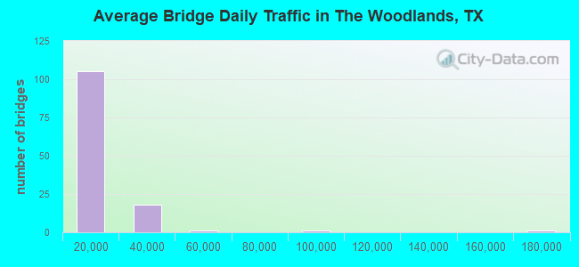
- 1,251,808Total average daily traffic
- 57,200Total average daily truck traffic
- National Bridge Inventory (NBI) Registered Bridges for The Woodlands
- No street view available for this location
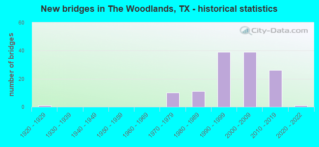
- New bridges - historical statistics
- 11920-1929
- 101970-1979
- 111980-1989
- 391990-1999
- 392000-2009
- 262010-2019
- 12020-2022
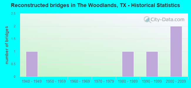
- Reconstructed bridges - Historical Statistics
- 11940-1949
- 01950-1959
- 01960-1969
- 01970-1979
- 11980-1989
- 11990-1999
- 22000-2009
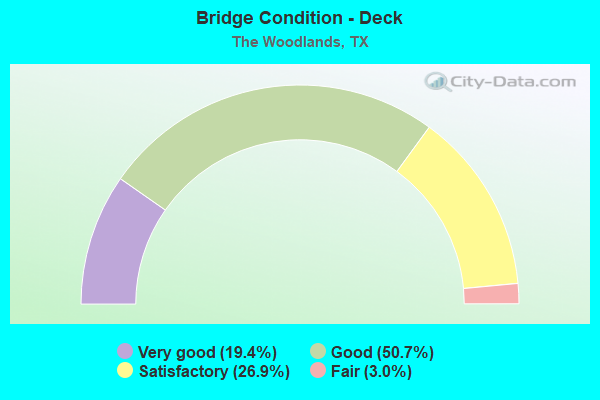
- Bridge Condition - Deck
- 19.4%Very good
- 50.7%Good
- 26.9%Satisfactory
- 3.0%Fair
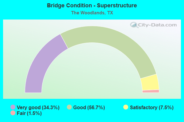
- Bridge Condition - Superstructure
- 34.3%Very good
- 56.7%Good
- 7.5%Satisfactory
- 1.5%Fair
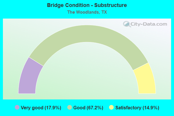
- Bridge Condition - Substructure
- 17.9%Very good
- 67.2%Good
- 14.9%Satisfactory
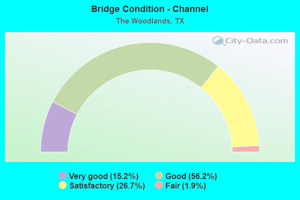
- Bridge Condition - Channel
- 15.2%Very good
- 56.2%Good
- 26.7%Satisfactory
- 1.9%Fair
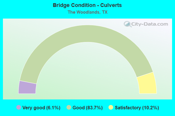
- Bridge Condition - Culverts
- 6.1%Very good
- 83.7%Good
- 10.2%Satisfactory
Find on map >> Show street view
Structure Number: 121700A00449018, Location: 0.2 MI NW OF MAY VALLEY C (Lat: 30.180269, Lng: -95.589767), Route carried "on" structure: County highway , Year Built: 2008, Status: Open, Structure Length: 0.73m (2.40ft), Average Daily Traffic: 50 (year 2016), Truck Traffic: 1%, Average Future Daily Traffic: 80 (year 2036), Features Intersected: DRAINAGE DITCH, Facility Carried by Structure: HAWKHURST DR
Minimum Vertical Clearance: 30+ m (98+ ft), Kilometerpoint: 0.322, Lanes on structure: 2, Owner: County Highway Agency, Approaching Roadway Width: 6.7m (22.0ft), Material/Design: Concrete, Design/Construction: Culvert, Number Of Spans In Main Unit: 2, Length of Maximum Span: 3.0m (9.8ft)
Condition: Channel: Good, Culverts: Good, Operating Rating: 32.7 metric tons, Method Used To Determine Operating Rating: Field evaluation and documented engineering judgment, Inventory Rating: 24.5 metric tons, Method Used To Determine Inventory Rating: Field evaluation and documented engineering judgment, Structural Evaluation: Equal to present minimum criteria, Waterway Adequacy: Superior to present desirable criteria, Approach Roadway Alignment: Equal to present desirable criteria, Designated Inspection Frequency: Every 24 months, Inspection Date: December 2021
Find on map >> Show street view
Structure Number: 121700A0052602, Location: 0.3 MI E OF COCHRANS CRS (Lat: 30.184644, Lng: -95.519656), Route carried "on" structure: County highway , Year Built: 1991, Status: Open, Structure Length: 0.73m (2.40ft), Average Daily Traffic: 60 (year 2016), Truck Traffic: 1%, Average Future Daily Traffic: 70 (year 2035), Features Intersected: DRAW, Facility Carried by Structure: HOLLYMEAD DR
Minimum Vertical Clearance: 30+ m (98+ ft), Kilometerpoint: 0.483, Lanes on structure: 2, Owner: County Highway Agency, Approaching Roadway Width: 7.9m (25.9ft), Material/Design: Concrete, Design/Construction: Culvert, Number Of Spans In Main Unit: 3, Length of Maximum Span: 1.8m (5.9ft)
Condition: Channel: Good, Culverts: Good, Operating Rating: 32.7 metric tons, Method Used To Determine Operating Rating: Field evaluation and documented engineering judgment, Inventory Rating: 24.5 metric tons, Method Used To Determine Inventory Rating: Field evaluation and documented engineering judgment, Structural Evaluation: Equal to present minimum criteria, Waterway Adequacy: Better than present minimum criteria, Approach Roadway Alignment: Equal to present desirable criteria, Designated Inspection Frequency: Every 24 months, Inspection Date: December 2021
Find on map >> Show street view
Structure Number: 121700A00773023, Location: 0.17 MI E OF WOODLOCH (Lat: 30.162261, Lng: -95.452561), Route carried "on" structure: County highway , Year Built: 1994, Status: Open, Structure Length: 2.59m (8.50ft), Average Daily Traffic: 5,000 (year 2016), Truck Traffic: 1%, Average Future Daily Traffic: 6,000 (year 2035), Design Load: HS 20, Features Intersected: WOODLANDS WATERWAY, Facility Carried by Structure: MALL RING RD
Minimum Vertical Clearance: 30+ m (98+ ft), Kilometerpoint: 0.805, Lanes on structure: 4, Owner: County Highway Agency, Approaching Roadway Width: 14.6m (47.9ft), Material/Design: Steel, Design/Construction: Truss - Deck, Number Of Spans In Main Unit: 1, Number Of Approach Spans: 1, Length of Maximum Span: 16.8m (55.1ft), Curb-To-Curb Width: 14.7m (48.2ft), Out-to-Out Width: 15.2m (49.9ft)
Condition: Deck: Good, Superstructure: Good, Substructure: Good, Channel: Very good, Operating Rating: 54.4 metric tons, Method Used To Determine Operating Rating: Assigned rating based on Load Factor Design (LFD) reported in metric tons, Inventory Rating: 32.7 metric tons, Method Used To Determine Inventory Rating: Assigned rating based on Load Factor Design (LFD) reported in metric tons, Structural Evaluation: Better than present minimum criteria, Deck Geometry: High priority of replacement, Waterway Adequacy: Superior to present desirable criteria, Approach Roadway Alignment: Equal to present desirable criteria, Designated Inspection Frequency: Every 24 months, Inspection Date: November 2021, Deck Structure Type: Concrete Cast-file-Place
Find on map >> Show street view
Structure Number: 121700A00868028, Location: 0.45 MI W OF IH45 (Lat: 30.140617, Lng: -95.453722), Route carried "on" structure: County highway , Year Built: 1990, Status: Open, Structure Length: 0.67m (2.20ft), Average Daily Traffic: 1,000 (year 2016), Truck Traffic: 1%, Average Future Daily Traffic: 1,500 (year 2035), Design Load: HS 20, Features Intersected: DRAINAGE DITCH, Facility Carried by Structure: NURSERY RD
Minimum Vertical Clearance: 30+ m (98+ ft), Kilometerpoint: 0.724, Lanes on structure: 2, Owner: County Highway Agency, Approaching Roadway Width: 6.7m (22.0ft), Material/Design: Concrete, Design/Construction: Culvert, Number Of Spans In Main Unit: 2, Length of Maximum Span: 3.0m (9.8ft)
Condition: Channel: Good, Culverts: Good, Operating Rating: 44.4 metric tons, Method Used To Determine Operating Rating: No rating analysis performed, Inventory Rating: 32.7 metric tons, Method Used To Determine Inventory Rating: No rating analysis performed, Structural Evaluation: Better than present minimum criteria, Waterway Adequacy: Equal to present minimum criteria, Approach Roadway Alignment: Equal to present desirable criteria, Designated Inspection Frequency: Every 24 months, Inspection Date: November 2021
Find on map >> Show street view
Structure Number: 121700A01114036, Location: 2.73 MI N OF FM 1488 (Lat: 30.259622, Lng: -95.563933), Route carried "on" structure: County highway , Year Built: 2009, Status: Open, Structure Length: 39.47m (129.49ft), Average Daily Traffic: 1,493 (year 2016), Truck Traffic: 1%, Average Future Daily Traffic: 2,500 (year 2035), Design Load: HL 93, Features Intersected: LAKE CREEK, Facility Carried by Structure: FISH CREEK TRFR NB
Minimum Vertical Clearance: 30+ m (98+ ft), Kilometerpoint: 4.394, Lanes on structure: 2, Owner: County Highway Agency, Approaching Roadway Width: 9.8m (32.2ft), Material/Design: Prestressed concrete, Design/Construction: Stringer/Multi-beam, Number Of Spans In Main Unit: 13, Length of Maximum Span: 35.1m (115.2ft), Curb-To-Curb Width: 11.7m (38.4ft), Out-to-Out Width: 12.3m (40.4ft)
Condition: Deck: Good, Superstructure: Good, Substructure: Good, Channel: Good, Operating Rating: 54.4 metric tons, Method Used To Determine Operating Rating: Assigned ratings based on Load and Resistance Factor Design (LRFD) reported in metric tons, Inventory Rating: 32.7 metric tons, Method Used To Determine Inventory Rating: Assigned ratings based on Load and Resistance Factor Design (LRFD) reported in metric tons, Structural Evaluation: Better than present minimum criteria, Deck Geometry: Better than present minimum criteria, Waterway Adequacy: Superior to present desirable criteria, Approach Roadway Alignment: Equal to present desirable criteria, Designated Inspection Frequency: Every 24 months, Inspection Date: December 2021, Deck Structure Type: Concrete Cast-file-Place
Find on map >> Show street view
Structure Number: 121700A01217038, Location: 0.6 MI W OF BRANCH CROS (Lat: 30.203164, Lng: -95.564519), Route carried "on" structure: County highway , Year Built: 2005, Status: Open, Structure Length: 0.79m (2.59ft), Average Daily Traffic: 5,047 (year 2016), Truck Traffic: 1%, Average Future Daily Traffic: 1,800 (year 2036), Design Load: HS 20, Features Intersected: DRAINAGE DITCH, Facility Carried by Structure: TERRAMONT DR
Minimum Vertical Clearance: 30+ m (98+ ft), Kilometerpoint: 2.736, Lanes on structure: 2, Owner: County Highway Agency, Approaching Roadway Width: 11.0m (36.1ft), Skew: 9 degrees, Material/Design: Concrete, Design/Construction: Culvert, Number Of Spans In Main Unit: 2, Length of Maximum Span: 3.0m (9.8ft), Curb or Sidewalk Widths: Left: 2.4m (7.9ft), Right: 0.0m
Condition: Channel: Good, Culverts: Good, Operating Rating: 54.4 metric tons, Method Used To Determine Operating Rating: Assigned rating based on Load Factor Design (LFD) reported in metric tons, Inventory Rating: 32.7 metric tons, Method Used To Determine Inventory Rating: Assigned rating based on Load Factor Design (LFD) reported in metric tons, Structural Evaluation: Better than present minimum criteria, Waterway Adequacy: Superior to present desirable criteria, Approach Roadway Alignment: Equal to present desirable criteria, Designated Inspection Frequency: Every 24 months, Inspection Date: December 2021
Find on map >> Show street view
Structure Number: 121700A01246033, Location: 0.41 MI W OF FISH CRK TFA (Lat: 30.246150, Lng: -95.569750), Route carried "on" structure: County highway , Year Built: 1997, Status: Open, Structure Length: 0.88m (2.89ft), Average Daily Traffic: 50 (year 2016), Truck Traffic: 1%, Average Future Daily Traffic: 60 (year 2036), Design Load: HL 93, Features Intersected: STOWE BRANCH, Facility Carried by Structure: S TRACE DR
Minimum Vertical Clearance: 30+ m (98+ ft), Kilometerpoint: 0.660, Lanes on structure: 2, Owner: County Highway Agency, Approaching Roadway Width: 7.0m (23.0ft), Skew: 3 degrees, Material/Design: Concrete, Design/Construction: Culvert, Number Of Spans In Main Unit: 3, Length of Maximum Span: 1.8m (5.9ft)
Condition: Channel: Good, Culverts: Good, Operating Rating: 54.4 metric tons, Method Used To Determine Operating Rating: Assigned ratings based on Load and Resistance Factor Design (LRFD) reported in metric tons, Inventory Rating: 32.7 metric tons, Method Used To Determine Inventory Rating: Assigned ratings based on Load and Resistance Factor Design (LRFD) reported in metric tons, Structural Evaluation: Better than present minimum criteria, Waterway Adequacy: Superior to present desirable criteria, Approach Roadway Alignment: Equal to present desirable criteria, Designated Inspection Frequency: Every 24 months, Inspection Date: December 2021
Find on map >> Show street view
Structure Number: 121700A2279601, Location: 0.20 MI NW OF SAN JACINTO (Lat: 30.234825, Lng: -95.428903), Route carried "on" structure: County highway , Year Built: 1990, Status: Open, Structure Length: 1.83m (6.00ft), Average Daily Traffic: 200 (year 2016), Truck Traffic: 1%, Average Future Daily Traffic: 250 (year 2036), Features Intersected: LITTLE CANEY CREEK, Facility Carried by Structure: W ESSEX DR
Minimum Vertical Clearance: 30+ m (98+ ft), Kilometerpoint: 0.322, Lanes on structure: 2, Owner: County Highway Agency, Approaching Roadway Width: 5.5m (18.0ft), Material/Design: Prestressed concrete, Number Of Spans In Main Unit: 2, Length of Maximum Span: 9.1m (29.9ft), Curb-To-Curb Width: 8.0m (26.2ft), Out-to-Out Width: 8.2m (26.9ft)
Condition: Deck: Satisfactory, Superstructure: Good, Substructure: Good, Channel: Fair, Operating Rating: 32.7 metric tons, Method Used To Determine Operating Rating: Field evaluation and documented engineering judgment, Inventory Rating: 24.5 metric tons, Method Used To Determine Inventory Rating: Field evaluation and documented engineering judgment, Structural Evaluation: Equal to present minimum criteria, Deck Geometry: Somewhat better than minimum adequacy, Waterway Adequacy: Better than present minimum criteria, Approach Roadway Alignment: Equal to present desirable criteria, Designated Inspection Frequency: Every 24 months, Inspection Date: December 2021, Deck Structure Type: Concrete Cast-file-Place
Find on map >> Show street view
Structure Number: 121700A3031401, Location: 0.10 MI N OF S TRADE CTR (Lat: 30.217808, Lng: -95.448761), Route carried "on" structure: County highway , Year Built: 2000, Status: Open, Structure Length: 6.40m (21.00ft), Average Daily Traffic: 3,000 (year 2016), Truck Traffic: 1%, Average Future Daily Traffic: 4,000 (year 2036), Features Intersected: HARPERS HORSEPEN, Facility Carried by Structure: S HARPERS LANDING
Minimum Vertical Clearance: 30+ m (98+ ft), Kilometerpoint: 0.161, Lanes on structure: 2, Owner: County Highway Agency, Approaching Roadway Width: 9.8m (32.2ft), Skew: 1 degrees, Material/Design: Prestressed concrete, Design/Construction: Stringer/Multi-beam, Number Of Spans In Main Unit: 3, Length of Maximum Span: 21.3m (69.9ft), Curb or Sidewalk Widths: Left: 0.0m, Right: 2.3m (7.5ft), Curb-To-Curb Width: 9.8m (32.2ft), Out-to-Out Width: 13.4m (44.0ft)
Condition: Deck: Very good, Superstructure: Very good, Substructure: Good, Channel: Good, Operating Rating: 32.7 metric tons, Method Used To Determine Operating Rating: Field evaluation and documented engineering judgment, Inventory Rating: 24.5 metric tons, Method Used To Determine Inventory Rating: Field evaluation and documented engineering judgment, Structural Evaluation: Equal to present minimum criteria, Deck Geometry: Meets minimum limits, Waterway Adequacy: Better than present minimum criteria, Approach Roadway Alignment: Equal to present desirable criteria, Designated Inspection Frequency: Every 24 months, Inspection Date: December 2021, Deck Structure Type: Concrete Precast Panels
Find on map >> Show street view
Structure Number: 121700A4550401, Location: 0.10 MI N OF SH 242 (Lat: 30.209658, Lng: -95.427186), Route carried "on" structure: County highway , Year Built: 2007, Status: Open, Structure Length: 1.10m (3.61ft), Average Daily Traffic: 2,000 (year 2016), Truck Traffic: 1%, Average Future Daily Traffic: 2,100 (year 2036), Features Intersected: DRAINAGE DITCH, Facility Carried by Structure: MONTGOMERY CRK TRL
Minimum Vertical Clearance: 30+ m (98+ ft), Kilometerpoint: 0.161, Lanes on structure: 2, Owner: County Highway Agency, Approaching Roadway Width: 12.2m (40.0ft), Material/Design: Concrete, Design/Construction: Culvert, Number Of Spans In Main Unit: 3, Length of Maximum Span: 3.0m (9.8ft), Curb or Sidewalk Widths: Left: 1.5m (4.9ft), Right: 1.5m (4.9ft)
Condition: Channel: Very good, Culverts: Good, Operating Rating: 32.7 metric tons, Method Used To Determine Operating Rating: Field evaluation and documented engineering judgment, Inventory Rating: 24.5 metric tons, Method Used To Determine Inventory Rating: Field evaluation and documented engineering judgment, Structural Evaluation: Equal to present minimum criteria, Waterway Adequacy: Better than present minimum criteria, Approach Roadway Alignment: Equal to present desirable criteria, Designated Inspection Frequency: Every 24 months, Inspection Date: December 2021
Find on map >> Show street view
Structure Number: 121700AA0481044, Location: 2.6 MI N OF FM 1488 (Lat: 30.256819, Lng: -95.578953), Route carried "on" structure: County highway , Year Built: 1989, Status: Open, Structure Length: 2.29m (7.51ft), Average Daily Traffic: 460 (year 2013), Truck Traffic: 2%, Average Future Daily Traffic: 800 (year 2033), Features Intersected: LAKE CREEK DRAW, Facility Carried by Structure: HONEA EGYPT RD
Minimum Vertical Clearance: 30+ m (98+ ft), Kilometerpoint: 4.233, Lanes on structure: 2, Owner: County Highway Agency, Approaching Roadway Width: 6.7m (22.0ft), Material/Design: Prestressed concrete, Design/Construction: Box Beam or Girders - Multiple, Number Of Spans In Main Unit: 2, Length of Maximum Span: 11.3m (37.1ft), Curb-To-Curb Width: 7.4m (24.3ft), Out-to-Out Width: 8.2m (26.9ft)
Condition: Deck: Very good, Superstructure: Very good, Substructure: Good, Channel: Good, Operating Rating: 32.7 metric tons, Method Used To Determine Operating Rating: Field evaluation and documented engineering judgment, Inventory Rating: 24.5 metric tons, Method Used To Determine Inventory Rating: Field evaluation and documented engineering judgment, Structural Evaluation: Equal to present minimum criteria, Deck Geometry: Meets minimum limits, Waterway Adequacy: Better than present minimum criteria, Approach Roadway Alignment: Equal to present desirable criteria, Designated Inspection Frequency: Every 24 months, Inspection Date: October 2021, Deck Structure Type: Concrete Cast-file-Place, Wearing Surface/Protective System: Wearing Surface: Bituminous
Find on map >> Show street view
Structure Number: 121700AA0481045, Location: 2.45 MI N OF FM 1488 (Lat: 30.253919, Lng: -95.579008), Route carried "on" structure: County highway , Year Built: 1991, Status: Open, Structure Length: 3.05m (10.01ft), Average Daily Traffic: 460 (year 2013), Truck Traffic: 2%, Average Future Daily Traffic: 800 (year 2033), Features Intersected: LAKE CREEK, Facility Carried by Structure: HONEA EGYPT RD
Minimum Vertical Clearance: 30+ m (98+ ft), Kilometerpoint: 3.943, Lanes on structure: 2, Owner: County Highway Agency, Approaching Roadway Width: 6.7m (22.0ft), Material/Design: Prestressed concrete, Design/Construction: Box Beam or Girders - Multiple, Number Of Spans In Main Unit: 3, Length of Maximum Span: 12.2m (40.0ft), Curb-To-Curb Width: 7.4m (24.3ft), Out-to-Out Width: 8.2m (26.9ft)
Condition: Deck: Very good, Superstructure: Good, Substructure: Satisfactory, Channel: Fair, Operating Rating: 32.7 metric tons, Method Used To Determine Operating Rating: Field evaluation and documented engineering judgment, Inventory Rating: 24.5 metric tons, Method Used To Determine Inventory Rating: Field evaluation and documented engineering judgment, Structural Evaluation: Equal to present minimum criteria, Deck Geometry: Meets minimum limits, Waterway Adequacy: Better than present minimum criteria, Approach Roadway Alignment: Equal to present desirable criteria, Designated Inspection Frequency: Every 24 months, Inspection Date: October 2021, Deck Structure Type: Concrete Precast Panels, Wearing Surface/Protective System: Wearing Surface: Bituminous
Find on map >> Show street view
Structure Number: 121700AA0506001, Location: 0.1 MI W OF OAK CREEK DR (Lat: 30.219239, Lng: -95.574458), Route carried "on" structure: County highway , Year Built: 1970, Status: Open, Structure Length: 0.70m (2.30ft), Average Daily Traffic: 250 (year 2015), Truck Traffic: 1%, Average Future Daily Traffic: 250 (year 2035), Features Intersected: NICKABURR CREEK, Facility Carried by Structure: NICKABURR CREEK DR
Minimum Vertical Clearance: 30+ m (98+ ft), Kilometerpoint: 0.161, Lanes on structure: 2, Owner: County Highway Agency, Approaching Roadway Width: 6.1m (20.0ft), Material/Design: Concrete, Design/Construction: Culvert, Number Of Spans In Main Unit: 3, Length of Maximum Span: 2.1m (6.9ft), Curb-To-Curb Width: 6.1m (20.0ft), Out-to-Out Width: 7.9m (25.9ft)
Condition: Channel: Satisfactory, Culverts: Satisfactory, Operating Rating: 32.7 metric tons, Method Used To Determine Operating Rating: Field evaluation and documented engineering judgment, Inventory Rating: 24.5 metric tons, Method Used To Determine Inventory Rating: Field evaluation and documented engineering judgment, Structural Evaluation: Equal to present minimum criteria, Deck Geometry: Meets minimum limits, Waterway Adequacy: Better than present minimum criteria, Approach Roadway Alignment: Equal to present desirable criteria, Length Of Structure Improvement: 0.67m (2.20ft), Designated Inspection Frequency: Every 24 months, Inspection Date: August 2021, Bridge Improvement Cost: $1,000, Total Project Cost: $1,000, Deck Structure Type: Concrete Cast-file-Place, Wearing Surface/Protective System: Wearing Surface: Bituminous
Find on map >> Show street view
Structure Number: 121700AA0507001, Location: 0.1 MI W OF COCHRANS CRSG (Lat: 30.199403, Lng: -95.529600), Route carried "on" structure: County highway , Year Built: 1992, Status: Open, Structure Length: 0.73m (2.40ft), Average Daily Traffic: 800 (year 2015), Truck Traffic: 5%, Average Future Daily Traffic: 800 (year 2035), Features Intersected: BEAR BRANCH TRIBUTARY, Facility Carried by Structure: WISTERIA WALK CIRC
Minimum Vertical Clearance: 30+ m (98+ ft), Kilometerpoint: 0.161, Lanes on structure: 2, Owner: County Highway Agency, Approaching Roadway Width: 7.3m (24.0ft), Material/Design: Concrete, Design/Construction: Culvert, Number Of Spans In Main Unit: 2, Length of Maximum Span: 3.0m (9.8ft), Curb or Sidewalk Widths: Left: 0.0m, Right: 2.4m (7.9ft)
Condition: Channel: Good, Culverts: Good, Operating Rating: 39.9 metric tons, Method Used To Determine Operating Rating: Load Factor (LF), Inventory Rating: 23.6 metric tons, Method Used To Determine Inventory Rating: Load Factor (LF), Structural Evaluation: Equal to present minimum criteria, Waterway Adequacy: Better than present minimum criteria, Approach Roadway Alignment: Equal to present desirable criteria, Designated Inspection Frequency: Every 24 months, Inspection Date: August 2021
Find on map >> Show street view
Structure Number: 121700AA0541001, Location: 0.6 MI NE OF RESEARCH FRS (Lat: 30.218003, Lng: -95.525625), Route carried "on" structure: County highway , Year Built: 1997, Status: Open, Structure Length: 1.13m (3.71ft), Average Daily Traffic: 5,375 (year 2020), Average Future Daily Traffic: 3,000 (year 2035), Design Load: HS 20, Features Intersected: ALDEN BRANCH, Facility Carried by Structure: N ALDEN BRIDGE DR
Minimum Vertical Clearance: 30+ m (98+ ft), Kilometerpoint: 0.966, Lanes on structure: 2, Owner: County Highway Agency, Approaching Roadway Width: 11.0m (36.1ft), Material/Design: Concrete, Design/Construction: Culvert, Number Of Spans In Main Unit: 3, Length of Maximum Span: 3.0m (9.8ft), Curb or Sidewalk Widths: Left: 2.4m (7.9ft), Right: 0.0m, Curb-To-Curb Width: 11.2m (36.7ft), Out-to-Out Width: 15.8m (51.8ft)
Condition: Channel: Good, Culverts: Good, Operating Rating: 39.9 metric tons, Method Used To Determine Operating Rating: Load Factor (LF), Inventory Rating: 23.6 metric tons, Method Used To Determine Inventory Rating: Load Factor (LF), Structural Evaluation: Somewhat better than minimum adequacy, Deck Geometry: Meets minimum limits, Waterway Adequacy: Better than present minimum criteria, Approach Roadway Alignment: Equal to present desirable criteria, Designated Inspection Frequency: Every 24 months, Inspection Date: August 2021, Deck Structure Type: Concrete Cast-file-Place, Wearing Surface/Protective System: Wearing Surface: Monolithic Concrete
Find on map >> Show street view
Structure Number: 121700AA0541002, Location: 1.0 MI W OF BRANCH X'ING (Lat: 30.210319, Lng: -95.565397), Route carried "on" structure: County highway , Year Built: 2001, Status: Open, Structure Length: 1.22m (4.00ft), Average Daily Traffic: 500 (year 2015), Average Future Daily Traffic: 1,000 (year 2035), Features Intersected: DRAINAGE DITCH, Facility Carried by Structure: W ALDEN BRIDGE DR
Minimum Vertical Clearance: 30+ m (98+ ft), Kilometerpoint: 1.609, Lanes on structure: 2, Owner: County Highway Agency, Approaching Roadway Width: 11.0m (36.1ft), Skew: 9 degrees, Material/Design: Concrete, Design/Construction: Culvert, Number Of Spans In Main Unit: 3, Length of Maximum Span: 3.0m (9.8ft), Curb or Sidewalk Widths: Left: 2.4m (7.9ft), Right: 0.0m
Condition: Channel: Good, Culverts: Good, Operating Rating: 54.4 metric tons, Method Used To Determine Operating Rating: Assigned rating based on Load Factor Design (LFD) reported in metric tons, Inventory Rating: 32.7 metric tons, Method Used To Determine Inventory Rating: Assigned rating based on Load Factor Design (LFD) reported in metric tons, Structural Evaluation: Better than present minimum criteria, Waterway Adequacy: Better than present minimum criteria, Approach Roadway Alignment: Equal to present desirable criteria, Designated Inspection Frequency: Every 24 months, Inspection Date: August 2021
Find on map >> Show street view
Structure Number: 121700AA0541003, Location: 0.6 MI NE RESEARCH FRST (Lat: 30.210761, Lng: -95.513908), Route carried "on" structure: County highway , Year Built: 1994, Status: Open, Structure Length: 2.29m (7.51ft), Average Daily Traffic: 5,375 (year 2020), Average Future Daily Traffic: 3,000 (year 2035), Features Intersected: ALDEN BRANCH, Facility Carried by Structure: ALDEN BRIDGE DR
Minimum Vertical Clearance: 30+ m (98+ ft), Kilometerpoint: 0.966, Lanes on structure: 2, Owner: County Highway Agency, Approaching Roadway Width: 11.0m (36.1ft), Material/Design: Masonry, Design/Construction: Arch - Deck, Number Of Spans In Main Unit: 3, Length of Maximum Span: 7.6m (24.9ft), Curb-To-Curb Width: 11.1m (36.4ft), Out-to-Out Width: 12.2m (40.0ft)
Condition: Deck: Good, Superstructure: Good, Substructure: Very good, Channel: Very good, Operating Rating: 54.4 metric tons, Method Used To Determine Operating Rating: Assigned rating based on Load Factor Design (LFD) reported in metric tons, Inventory Rating: 32.7 metric tons, Method Used To Determine Inventory Rating: Assigned rating based on Load Factor Design (LFD) reported in metric tons, Structural Evaluation: Better than present minimum criteria, Deck Geometry: Meets minimum limits, Waterway Adequacy: Superior to present desirable criteria, Approach Roadway Alignment: Equal to present desirable criteria, Designated Inspection Frequency: Every 24 months, Inspection Date: August 2021, Deck Structure Type: Other, Wearing Surface/Protective System: Wearing Surface: Monolithic Concrete
Find on map >> Show street view
Structure Number: 121700AA0541004, Location: 0.25 MI W OF BRANCH X'ING (Lat: 30.209872, Lng: -95.554439), Route carried "on" structure: County highway , Year Built: 1998, Status: Open, Structure Length: 1.89m (6.20ft), Average Daily Traffic: 5,338 (year 2020), Average Future Daily Traffic: 3,000 (year 2035), Features Intersected: DRAINAGE DITCH, Facility Carried by Structure: ALDEN BRIDGE DR
Minimum Vertical Clearance: 30+ m (98+ ft), Kilometerpoint: 0.402, Lanes on structure: 2, Owner: County Highway Agency, Approaching Roadway Width: 11.0m (36.1ft), Skew: 9 degrees, Material/Design: Concrete, Design/Construction: Culvert, Number Of Spans In Main Unit: 5, Length of Maximum Span: 3.0m (9.8ft), Curb or Sidewalk Widths: Left: 2.4m (7.9ft), Right: 0.0m
Condition: Channel: Good, Culverts: Good, Operating Rating: 39.9 metric tons, Method Used To Determine Operating Rating: Load Factor (LF), Inventory Rating: 23.6 metric tons, Method Used To Determine Inventory Rating: Load Factor (LF), Structural Evaluation: Somewhat better than minimum adequacy, Waterway Adequacy: Better than present minimum criteria, Approach Roadway Alignment: Equal to present desirable criteria, Designated Inspection Frequency: Every 24 months, Inspection Date: August 2021
Find on map >> Show street view
Structure Number: 121700AA0547001, Location: 0.1 MI S OF WOODLANDS PKY (Lat: 30.183950, Lng: -95.568011), Route carried "on" structure: County highway , Year Built: 2004, Status: Open, Structure Length: 1.55m (5.09ft), Average Daily Traffic: 6,996 (year 2016), Truck Traffic: 5%, Average Future Daily Traffic: 2,400 (year 2035), Design Load: HS 20, Features Intersected: DRAINAGE DITCH, Facility Carried by Structure: W BRANCH CROSSING
Minimum Vertical Clearance: 30+ m (98+ ft), Kilometerpoint: 0.161, Lanes on structure: 4, Owner: County Highway Agency, Approaching Roadway Width: 11.0m (36.1ft), Skew: 9 degrees, Material/Design: Concrete, Design/Construction: Culvert, Number Of Spans In Main Unit: 3, Length of Maximum Span: 2.7m (8.9ft)
Condition: Channel: Satisfactory, Culverts: Good, Operating Rating: 54.4 metric tons, Method Used To Determine Operating Rating: Assigned rating based on Load Factor Design (LFD) reported in metric tons, Inventory Rating: 32.7 metric tons, Method Used To Determine Inventory Rating: Assigned rating based on Load Factor Design (LFD) reported in metric tons, Structural Evaluation: Better than present minimum criteria, Waterway Adequacy: Better than present minimum criteria, Approach Roadway Alignment: Equal to present desirable criteria, Designated Inspection Frequency: Every 24 months, Inspection Date: August 2021
Find on map >> Show street view
Structure Number: 121700AA0547002, Location: 0.85 MI S OF WOODLANDS P (Lat: 30.178097, Lng: -95.584256), Route carried "on" structure: County highway , Year Built: 2005, Status: Open, Structure Length: 1.95m (6.40ft), Average Daily Traffic: 4,922 (year 2020), Truck Traffic: 1%, Average Future Daily Traffic: 2,400 (year 2036), Features Intersected: DRAINAGE DITCH, Facility Carried by Structure: W BRANCH CROSSING
Minimum Vertical Clearance: 30+ m (98+ ft), Kilometerpoint: 1.368, Lanes on structure: 2, Owner: County Highway Agency, Approaching Roadway Width: 9.8m (32.2ft), Skew: 4 degrees, Material/Design: Concrete, Design/Construction: Culvert, Number Of Spans In Main Unit: 4, Length of Maximum Span: 3.0m (9.8ft), Curb or Sidewalk Widths: Left: 0.0m, Right: 2.4m (7.9ft)
Condition: Channel: Good, Culverts: Good, Operating Rating: 32.7 metric tons, Method Used To Determine Operating Rating: Field evaluation and documented engineering judgment, Inventory Rating: 24.5 metric tons, Method Used To Determine Inventory Rating: Field evaluation and documented engineering judgment, Structural Evaluation: Equal to present minimum criteria, Waterway Adequacy: Equal to present minimum criteria, Approach Roadway Alignment: Equal to present desirable criteria, Designated Inspection Frequency: Every 24 months, Inspection Date: December 2021
Find on map >> Show street view
Structure Number: 121700AA0554001, Location: 0.3 MI SW OF SH 242 (Lat: 30.208058, Lng: -95.505272), Route carried "on" structure: County highway , Year Built: 1996, Status: Open, Structure Length: 7.77m (25.49ft), Average Daily Traffic: 5,000 (year 2015), Average Future Daily Traffic: 7,000 (year 2035), Design Load: HS 20, Features Intersected: PANTHER BRANCH, Facility Carried by Structure: GREENBRIDGE DR WB
Minimum Vertical Clearance: 30+ m (98+ ft), Kilometerpoint: 0.483, Lanes on structure: 2, Owner: County Highway Agency, Approaching Roadway Width: 11.0m (36.1ft), Material/Design: Prestressed concrete, Design/Construction: Stringer/Multi-beam, Number Of Spans In Main Unit: 3, Length of Maximum Span: 25.9m (85.0ft), Curb or Sidewalk Widths: Left: 2.4m (7.9ft), Right: 0.0m, Curb-To-Curb Width: 8.5m (27.9ft), Out-to-Out Width: 12.2m (40.0ft)
Condition: Deck: Good, Superstructure: Good, Substructure: Very good, Channel: Good, Operating Rating: 54.4 metric tons, Method Used To Determine Operating Rating: Assigned rating based on Load Factor Design (LFD) reported in metric tons, Inventory Rating: 32.7 metric tons, Method Used To Determine Inventory Rating: Assigned rating based on Load Factor Design (LFD) reported in metric tons, Structural Evaluation: Better than present minimum criteria, Deck Geometry: High priority of corrective action, Waterway Adequacy: Superior to present desirable criteria, Approach Roadway Alignment: Equal to present desirable criteria, Length Of Structure Improvement: 7.77m (25.49ft), Designated Inspection Frequency: Every 24 months, Inspection Date: August 2021, Bridge Improvement Cost: $14,000, Roadway Improvement Cost: $4,000, Total Project Cost: $18,000, Deck Structure Type: Concrete Cast-file-Place
Find on map >> Show street view
Structure Number: 121700AA0554002, Location: 0.3 MI SW OF SH 242 (Lat: 30.207967, Lng: -95.505203), Route carried "on" structure: County highway , Year Built: 2004, Status: Open, Structure Length: 7.77m (25.49ft), Average Daily Traffic: 5,000 (year 2015), Average Future Daily Traffic: 7,000 (year 2035), Design Load: HS 20, Features Intersected: PANTHER BRANCH, Facility Carried by Structure: GREENBRIDGE DR EB
Minimum Vertical Clearance: 30+ m (98+ ft), Kilometerpoint: 0.483, Lanes on structure: 2, Owner: County Highway Agency, Approaching Roadway Width: 11.0m (36.1ft), Material/Design: Prestressed concrete, Design/Construction: Stringer/Multi-beam, Number Of Spans In Main Unit: 3, Length of Maximum Span: 25.9m (85.0ft), Curb-To-Curb Width: 8.5m (27.9ft), Out-to-Out Width: 9.4m (30.8ft)
Condition: Deck: Good, Superstructure: Very good, Substructure: Very good, Channel: Good, Operating Rating: 54.4 metric tons, Method Used To Determine Operating Rating: Assigned rating based on Load Factor Design (LFD) reported in metric tons, Inventory Rating: 32.7 metric tons, Method Used To Determine Inventory Rating: Assigned rating based on Load Factor Design (LFD) reported in metric tons, Structural Evaluation: Equal to present desirable criteria, Deck Geometry: High priority of corrective action, Waterway Adequacy: Superior to present desirable criteria, Approach Roadway Alignment: Equal to present desirable criteria, Length Of Structure Improvement: 7.77m (25.49ft), Designated Inspection Frequency: Every 24 months, Inspection Date: August 2021, Bridge Improvement Cost: $14,000, Roadway Improvement Cost: $4,000, Total Project Cost: $18,000, Deck Structure Type: Concrete Cast-file-Place
Find on map >> Show street view
Structure Number: 121700AA0567001, Location: 0.1 MI NE OF ALDEN BRIDGE (Lat: 30.211678, Lng: -95.555028), Route carried "on" structure: County highway , Year Built: 1998, Status: Open, Structure Length: 1.13m (3.71ft), Average Daily Traffic: 500 (year 2015), Average Future Daily Traffic: 600 (year 2035), Features Intersected: DRAINAGE DITCH, Facility Carried by Structure: SUNDANCE CIRCLE
Minimum Vertical Clearance: 30+ m (98+ ft), Kilometerpoint: 0.161, Lanes on structure: 2, Owner: County Highway Agency, Approaching Roadway Width: 7.0m (23.0ft), Skew: 1 degrees, Material/Design: Concrete, Design/Construction: Culvert, Number Of Spans In Main Unit: 3, Length of Maximum Span: 3.0m (9.8ft), Curb or Sidewalk Widths: Left: 2.4m (7.9ft), Right: 0.0m
Condition: Channel: Good, Culverts: Good, Operating Rating: 39.9 metric tons, Method Used To Determine Operating Rating: Load Factor (LF), Inventory Rating: 23.6 metric tons, Method Used To Determine Inventory Rating: Load Factor (LF), Structural Evaluation: Equal to present minimum criteria, Waterway Adequacy: Better than present minimum criteria, Approach Roadway Alignment: Equal to present desirable criteria, Designated Inspection Frequency: Every 24 months, Inspection Date: August 2021
Find on map >> Show street view
Structure Number: 121700AA0595001, Location: 0.9 MI S OF SH 242 (Lat: 30.191378, Lng: -95.481061), Route carried "on" structure: County highway , Year Built: 2000, Status: Open, Structure Length: 14.63m (48.00ft), Average Daily Traffic: 10,038 (year 2020), Average Future Daily Traffic: 6,000 (year 2032), Design Load: HS 20, Features Intersected: PANTHER BRANCH, Facility Carried by Structure: GOSLING RD NB
Minimum Vertical Clearance: 30+ m (98+ ft), Kilometerpoint: 1.448, Lanes on structure: 2, Owner: County Highway Agency, Approaching Roadway Width: 10.7m (35.1ft), Material/Design: Prestressed concrete, Design/Construction: Stringer/Multi-beam, Number Of Spans In Main Unit: 6, Length of Maximum Span: 24.4m (80.1ft), Curb-To-Curb Width: 11.0m (36.1ft), Out-to-Out Width: 11.6m (38.1ft)
Condition: Deck: Good, Superstructure: Good, Substructure: Good, Channel: Good, Operating Rating: 54.4 metric tons, Method Used To Determine Operating Rating: Assigned rating based on Load Factor Design (LFD) reported in metric tons, Inventory Rating: 32.7 metric tons, Method Used To Determine Inventory Rating: Assigned rating based on Load Factor Design (LFD) reported in metric tons, Structural Evaluation: Better than present minimum criteria, Deck Geometry: Equal to present minimum criteria, Waterway Adequacy: Superior to present desirable criteria, Approach Roadway Alignment: Equal to present desirable criteria, Designated Inspection Frequency: Every 24 months, Inspection Date: November 2021, Deck Structure Type: Concrete Cast-file-Place
Find on map >> Show street view
Structure Number: 121700AA0595002, Location: 0.9 MI S OF SH 242 (Lat: 30.192625, Lng: -95.480833), Route carried "on" structure: County highway , Year Built: 1992, Status: Open, Structure Length: 14.63m (48.00ft), Average Daily Traffic: 9,560 (year 2020), Average Future Daily Traffic: 6,000 (year 2032), Design Load: HS 20, Features Intersected: PANTHER BRANCH, Facility Carried by Structure: GOSLING RD SB
Minimum Vertical Clearance: 30+ m (98+ ft), Kilometerpoint: 1.368, Lanes on structure: 2, Owner: County Highway Agency, Approaching Roadway Width: 11.0m (36.1ft), Material/Design: Prestressed concrete, Design/Construction: Stringer/Multi-beam, Number Of Spans In Main Unit: 6, Length of Maximum Span: 24.4m (80.1ft), Curb or Sidewalk Widths: Left: 2.4m (7.9ft), Right: 0.0m, Curb-To-Curb Width: 11.0m (36.1ft), Out-to-Out Width: 14.4m (47.2ft)
Condition: Deck: Very good, Superstructure: Good, Substructure: Good, Channel: Good, Operating Rating: 54.4 metric tons, Method Used To Determine Operating Rating: Assigned rating based on Load Factor Design (LFD) reported in metric tons, Inventory Rating: 32.7 metric tons, Method Used To Determine Inventory Rating: Assigned rating based on Load Factor Design (LFD) reported in metric tons, Structural Evaluation: Better than present minimum criteria, Deck Geometry: Equal to present minimum criteria, Waterway Adequacy: Better than present minimum criteria, Approach Roadway Alignment: Equal to present desirable criteria, Designated Inspection Frequency: Every 24 months, Inspection Date: November 2021, Deck Structure Type: Concrete Cast-file-Place
Find on map >> Show street view
Structure Number: 121700AA0599001, Location: 0.2 MI N OF WOODLANDS Pk (Lat: 30.160047, Lng: -95.455969), Route carried "on" structure: City street , Year Built: 1999, Status: Open, Structure Length: 2.83m (9.28ft), Average Daily Traffic: 400 (year 2013), Average Future Daily Traffic: 480 (year 2033), Design Load: HS 20, Features Intersected: WOODLANDS WATERWAY, Facility Carried by Structure: WOODLOCH FOREST SB
Minimum Vertical Clearance: 30+ m (98+ ft), Kilometerpoint: 0.644, Lanes on structure: 2, Owner: Town or Township Highway Agency, Approaching Roadway Width: 7.3m (24.0ft), Material/Design: Prestressed concrete continuous, Number Of Spans In Main Unit: 1, Number Of Approach Spans: 1, Length of Maximum Span: 20.1m (65.9ft), Curb or Sidewalk Widths: Left: 0.0m, Right: 2.7m (8.9ft), Curb-To-Curb Width: 7.4m (24.3ft), Out-to-Out Width: 10.8m (35.4ft)
Condition: Deck: Good, Superstructure: Good, Substructure: Good, Channel: Very good, Operating Rating: 54.4 metric tons, Method Used To Determine Operating Rating: Assigned rating based on Load Factor Design (LFD) reported in metric tons, Inventory Rating: 32.7 metric tons, Method Used To Determine Inventory Rating: Assigned rating based on Load Factor Design (LFD) reported in metric tons, Structural Evaluation: Better than present minimum criteria, Deck Geometry: High priority of replacement, Waterway Adequacy: Superior to present desirable criteria, Approach Roadway Alignment: Equal to present desirable criteria, Designated Inspection Frequency: Every 24 months, Inspection Date: November 2021, Deck Structure Type: Concrete Cast-file-Place
Find on map >> Show street view
Structure Number: 121700AA0599002, Location: 0.2 MI N OF WOODLANDS Pk (Lat: 30.159831, Lng: -95.455519), Route carried "on" structure: City street , Year Built: 1999, Status: Open, Structure Length: 2.83m (9.28ft), Average Daily Traffic: 400 (year 2013), Average Future Daily Traffic: 480 (year 2033), Design Load: HS 20, Features Intersected: WOODLANDS WATERWAY, Facility Carried by Structure: WOODLOCH FOREST NB
Minimum Vertical Clearance: 30+ m (98+ ft), Kilometerpoint: 0.644, Lanes on structure: 2, Owner: Town or Township Highway Agency, Approaching Roadway Width: 7.3m (24.0ft), Material/Design: Prestressed concrete continuous, Number Of Spans In Main Unit: 1, Number Of Approach Spans: 1, Length of Maximum Span: 20.1m (65.9ft), Curb or Sidewalk Widths: Left: 0.0m, Right: 2.7m (8.9ft), Curb-To-Curb Width: 7.3m (24.0ft), Out-to-Out Width: 10.8m (35.4ft)
Condition: Deck: Good, Superstructure: Good, Substructure: Good, Channel: Very good, Operating Rating: 54.4 metric tons, Method Used To Determine Operating Rating: Assigned rating based on Load Factor Design (LFD) reported in metric tons, Inventory Rating: 32.7 metric tons, Method Used To Determine Inventory Rating: Assigned rating based on Load Factor Design (LFD) reported in metric tons, Structural Evaluation: Better than present minimum criteria, Deck Geometry: High priority of replacement, Waterway Adequacy: Superior to present desirable criteria, Approach Roadway Alignment: Equal to present desirable criteria, Designated Inspection Frequency: Every 24 months, Inspection Date: November 2021, Deck Structure Type: Concrete Cast-file-Place
Find on map >> Show street view
Structure Number: 121700AA0601001, Location: 5.3 MI W OF IH 45 (Lat: 30.160156, Lng: -95.497917), Route carried "on" structure: County highway , Year Built: 1985, Year Reconstructed: 2009, Status: Open, Structure Length: 1.28m (4.20ft), Average Daily Traffic: 18,500 (year 2020), Truck Traffic: 1%, Average Future Daily Traffic: 12,280 (year 2033), Design Load: HS 20, Features Intersected: DRAINAGE DITCH, Facility Carried by Structure: WOODLANDS PKWY EB
Minimum Vertical Clearance: 30+ m (98+ ft), Kilometerpoint: 1.609, Lanes on structure: 3, Owner: County Highway Agency, Approaching Roadway Width: 12.2m (40.0ft), Material/Design: Concrete, Design/Construction: Stringer/Multi-beam, Number Of Spans In Main Unit: 1, Length of Maximum Span: 12.2m (40.0ft), Curb or Sidewalk Widths: Left: 1.0m (3.3ft), Right: 1.6m (5.2ft), Curb-To-Curb Width: 12.0m (39.4ft), Out-to-Out Width: 15.2m (49.9ft)
Condition: Deck: Satisfactory, Superstructure: Good, Substructure: Good, Channel: Good, Operating Rating: 68.0 metric tons, Method Used To Determine Operating Rating: Load Factor (LF), Inventory Rating: 40.8 metric tons, Method Used To Determine Inventory Rating: Load Factor (LF), Structural Evaluation: Better than present minimum criteria, Deck Geometry: Meets minimum limits, Waterway Adequacy: Equal to present minimum criteria, Approach Roadway Alignment: Equal to present desirable criteria, Designated Inspection Frequency: Every 24 months, Inspection Date: November 2021, Deck Structure Type: Concrete Cast-file-Place
Find on map >> Show street view
Structure Number: 121700AA0601002, Location: 1.5 MI W OF IH 45 (Lat: 30.155406, Lng: -95.472581), Route carried "on" structure: County highway , Year Built: 1999, Status: Open, Structure Length: 7.68m (25.20ft), Average Daily Traffic: 17,802 (year 2020), Truck Traffic: 2%, Average Future Daily Traffic: 12,280 (year 2033), Design Load: HS 20, Features Intersected: GROGANS MILL RD, Facility Carried by Structure: WOODLANDS PKWY EB
Minimum Vertical Clearance: 30+ m (98+ ft), Kilometerpoint: 0.002, Lanes on structure: 3, Lanes under structure: 8, Owner: County Highway Agency, Approaching Roadway Width: 11.0m (36.1ft), Skew: 2 degrees, Material/Design: Prestressed concrete, Number Of Spans In Main Unit: 2, Length of Maximum Span: 38.4m (126.0ft), Curb-To-Curb Width: 11.0m (36.1ft), Out-to-Out Width: 11.9m (39.0ft)
Condition: Deck: Good, Superstructure: Good, Substructure: Good, Operating Rating: 54.4 metric tons, Method Used To Determine Operating Rating: Assigned rating based on Load Factor Design (LFD) reported in metric tons, Inventory Rating: 32.7 metric tons, Method Used To Determine Inventory Rating: Assigned rating based on Load Factor Design (LFD) reported in metric tons, Structural Evaluation: Better than present minimum criteria, Deck Geometry: High priority of replacement, Underclear: Superior to present desirable criteria, Approach Roadway Alignment: Equal to present desirable criteria, Length Of Structure Improvement: 7.68m (25.20ft), Designated Inspection Frequency: Every 24 months, Inspection Date: November 2021, Bridge Improvement Cost: $18,000, Roadway Improvement Cost: $5,000, Total Project Cost: $23,000, Deck Structure Type: Concrete Precast Panels
Find on map >> Show street view
Structure Number: 121700AA0601003, Location: 1.5 MI W OF IH 45 (Lat: 30.155625, Lng: -95.472542), Route carried "on" structure: County highway , Year Built: 1999, Status: Open, Structure Length: 7.68m (25.20ft), Average Daily Traffic: 16,796 (year 2020), Truck Traffic: 2%, Average Future Daily Traffic: 12,280 (year 2033), Design Load: HS 20, Features Intersected: GROGANS MILL RD, Facility Carried by Structure: WOODLANDS PKWY WB
Minimum Vertical Clearance: 30+ m (98+ ft), Kilometerpoint: 0.002, Lanes on structure: 3, Lanes under structure: 7, Owner: County Highway Agency, Approaching Roadway Width: 11.0m (36.1ft), Skew: 2 degrees, Material/Design: Prestressed concrete, Number Of Spans In Main Unit: 2, Length of Maximum Span: 38.4m (126.0ft), Curb-To-Curb Width: 14.7m (48.2ft), Out-to-Out Width: 15.6m (51.2ft)
Condition: Deck: Good, Superstructure: Good, Substructure: Good, Operating Rating: 54.4 metric tons, Method Used To Determine Operating Rating: Assigned rating based on Load Factor Design (LFD) reported in metric tons, Inventory Rating: 32.7 metric tons, Method Used To Determine Inventory Rating: Assigned rating based on Load Factor Design (LFD) reported in metric tons, Structural Evaluation: Better than present minimum criteria, Deck Geometry: Somewhat better than minimum adequacy, Underclear: Superior to present desirable criteria, Approach Roadway Alignment: Equal to present desirable criteria, Designated Inspection Frequency: Every 24 months, Inspection Date: November 2021, Deck Structure Type: Concrete Precast Panels
Find on map >> Show street view
Structure Number: 121700AA060112, Location: 1.0 MI W OF GROGANS MILL (Lat: 30.154425, Lng: -95.483572), Route carried "on" structure: County highway , Year Built: 1977, Year Reconstructed: 2014, Status: Open, Structure Length: 12.34m (40.49ft), Average Daily Traffic: 41,574 (year 2020), Truck Traffic: 2%, Average Future Daily Traffic: 27,830 (year 2032), Design Load: HS 20, Features Intersected: PANTHER BRANCH, Facility Carried by Structure: WOODLANDS PKWY
Minimum Vertical Clearance: 30+ m (98+ ft), Kilometerpoint: 3.219, Lanes on structure: 6, Owner: County Highway Agency, Approaching Roadway Width: 25.6m (84.0ft), Skew: 30 degrees, Material/Design: Concrete, Design/Construction: Stringer/Multi-beam, Number Of Spans In Main Unit: 10, Length of Maximum Span: 12.2m (40.0ft), Curb or Sidewalk Widths: Left: 1.1m (3.6ft), Right: 1.1m (3.6ft), Curb-To-Curb Width: 24.0m (78.7ft), Out-to-Out Width: 27.4m (89.9ft)
Condition: Deck: Satisfactory, Superstructure: Satisfactory, Substructure: Good, Channel: Good, Operating Rating: 54.4 metric tons, Method Used To Determine Operating Rating: Assigned rating based on Load Factor Design (LFD) reported in metric tons, Inventory Rating: 32.7 metric tons, Method Used To Determine Inventory Rating: Assigned rating based on Load Factor Design (LFD) reported in metric tons, Structural Evaluation: Equal to present minimum criteria, Deck Geometry: Somewhat better than minimum adequacy, Waterway Adequacy: Superior to present desirable criteria, Approach Roadway Alignment: Equal to present desirable criteria, Length Of Structure Improvement: 12.34m (40.49ft), Designated Inspection Frequency: Every 24 months, Inspection Date: November 2021, Bridge Improvement Cost: $39,000, Roadway Improvement Cost: $10,000, Total Project Cost: $49,000, Deck Structure Type: Concrete Cast-file-Place
Find on map >> Show street view
Structure Number: 121700AA0601123, Location: 0.5 MI SE OF FM 2978 (Lat: 30.188450, Lng: -95.583150), Route carried "on" structure: County highway , Year Built: 2001, Status: Open, Structure Length: 0.67m (2.20ft), Average Daily Traffic: 13,787 (year 2020), Truck Traffic: 5%, Average Future Daily Traffic: 27,850 (year 2035), Design Load: HS 20, Features Intersected: SPRING CREEK TRIBUTARY, Facility Carried by Structure: WOODLANDS PKWY
Minimum Vertical Clearance: 30+ m (98+ ft), Kilometerpoint: 0.805, Lanes on structure: 4, Owner: County Highway Agency, Approaching Roadway Width: 19.5m (64.0ft), Skew: 29 degrees, Material/Design: Concrete, Design/Construction: Culvert, Number Of Spans In Main Unit: 2, Length of Maximum Span: 3.0m (9.8ft), Curb or Sidewalk Widths: Left: 0.0m, Right: 2.4m (7.9ft)
Condition: Channel: Good, Culverts: Good, Operating Rating: 54.4 metric tons, Method Used To Determine Operating Rating: Assigned rating based on Load Factor Design (LFD) reported in metric tons, Inventory Rating: 32.7 metric tons, Method Used To Determine Inventory Rating: Assigned rating based on Load Factor Design (LFD) reported in metric tons, Structural Evaluation: Better than present minimum criteria, Waterway Adequacy: Equal to present minimum criteria, Approach Roadway Alignment: Equal to present desirable criteria, Designated Inspection Frequency: Every 24 months, Inspection Date: August 2021
Find on map >> Show street view
Structure Number: 121700AA0601124, Location: 2.4 MI E OF FM 2978 (Lat: 30.181783, Lng: -95.555928), Route carried "on" structure: County highway , Year Built: 2000, Status: Open, Structure Length: 1.01m (3.31ft), Average Daily Traffic: 24,947 (year 2020), Truck Traffic: 5%, Average Future Daily Traffic: 27,850 (year 2035), Features Intersected: SPRING CREEK TRIBUTARY, Facility Carried by Structure: WOODLANDS PKWY
Minimum Vertical Clearance: 30+ m (98+ ft), Kilometerpoint: 3.862, Lanes on structure: 4, Owner: County Highway Agency, Approaching Roadway Width: 19.5m (64.0ft), Skew: 20 degrees, Material/Design: Concrete, Design/Construction: Culvert, Number Of Spans In Main Unit: 3, Length of Maximum Span: 2.7m (8.9ft), Curb or Sidewalk Widths: Left: 0.0m, Right: 2.4m (7.9ft)
Condition: Channel: Satisfactory, Culverts: Good, Operating Rating: 32.7 metric tons, Method Used To Determine Operating Rating: Field evaluation and documented engineering judgment, Inventory Rating: 24.5 metric tons, Method Used To Determine Inventory Rating: Field evaluation and documented engineering judgment, Structural Evaluation: Equal to present minimum criteria, Waterway Adequacy: Equal to present minimum criteria, Approach Roadway Alignment: Equal to present desirable criteria, Designated Inspection Frequency: Every 24 months, Inspection Date: August 2021
Find on map >> Show street view
Structure Number: 121700AA0601125, Location: 2.9 MI E OF FM 2978 (Lat: 30.181183, Lng: -95.546631), Route carried "on" structure: County highway , Year Built: 2000, Status: Open, Structure Length: 0.82m (2.69ft), Average Daily Traffic: 24,947 (year 2020), Truck Traffic: 5%, Average Future Daily Traffic: 27,850 (year 2035), Features Intersected: SPRING CREEK TRIBUTARY, Facility Carried by Structure: WOODLANDS PKWY
Minimum Vertical Clearance: 30+ m (98+ ft), Kilometerpoint: 4.667, Lanes on structure: 4, Owner: County Highway Agency, Approaching Roadway Width: 19.5m (64.0ft), Skew: 20 degrees, Material/Design: Concrete, Design/Construction: Culvert, Number Of Spans In Main Unit: 3, Length of Maximum Span: 2.1m (6.9ft)
Condition: Channel: Good, Culverts: Good, Operating Rating: 32.7 metric tons, Method Used To Determine Operating Rating: Field evaluation and documented engineering judgment, Inventory Rating: 24.5 metric tons, Method Used To Determine Inventory Rating: Field evaluation and documented engineering judgment, Structural Evaluation: Equal to present minimum criteria, Waterway Adequacy: Equal to present minimum criteria, Approach Roadway Alignment: Equal to present desirable criteria, Designated Inspection Frequency: Every 24 months, Inspection Date: August 2021
Find on map >> Show street view
Structure Number: 121700AA0601126, Location: 3.3 MI E OF FM 2978 (Lat: 30.181697, Lng: -95.540878), Route carried "on" structure: County highway , Year Built: 2000, Status: Open, Structure Length: 0.88m (2.89ft), Average Daily Traffic: 24,947 (year 2020), Average Future Daily Traffic: 27,850 (year 2035), Design Load: HS 20, Features Intersected: DRAINAGE DITCH, Facility Carried by Structure: WOODLANDS PKWY
Minimum Vertical Clearance: 30+ m (98+ ft), Kilometerpoint: 5.311, Lanes on structure: 5, Owner: County Highway Agency, Approaching Roadway Width: 19.5m (64.0ft), Skew: 20 degrees, Material/Design: Concrete, Design/Construction: Culvert, Number Of Spans In Main Unit: 3, Length of Maximum Span: 2.4m (7.9ft)
Condition: Channel: Satisfactory, Culverts: Good, Operating Rating: 54.4 metric tons, Method Used To Determine Operating Rating: Assigned rating based on Load Factor Design (LFD) reported in metric tons, Inventory Rating: 32.7 metric tons, Method Used To Determine Inventory Rating: Assigned rating based on Load Factor Design (LFD) reported in metric tons, Structural Evaluation: Better than present minimum criteria, Waterway Adequacy: Equal to present minimum criteria, Approach Roadway Alignment: Equal to present desirable criteria, Designated Inspection Frequency: Every 24 months, Inspection Date: August 2021
Find on map >> Show street view
Structure Number: 121700AA0666125, Location: 0.3 MI W OF MILLBEND DR (Lat: 30.134039, Lng: -95.477975), Route carried "on" structure: County highway , Year Built: 1989, Year Reconstructed: 1998, Status: Open, Structure Length: 4.08m (13.39ft), Average Daily Traffic: 10,284 (year 2016), Average Future Daily Traffic: 5,000 (year 2035), Design Load: HS 20, Features Intersected: PANTHER BRANCH, Facility Carried by Structure: SAWDUST RD
Minimum Vertical Clearance: 30+ m (98+ ft), Kilometerpoint: 1.127, Lanes on structure: 4, Owner: County Highway Agency, Approaching Roadway Width: 17.1m (56.1ft), Skew: 1 degrees, Material/Design: Prestressed concrete, Design/Construction: Box Beam or Girders - Multiple, Number Of Spans In Main Unit: 3, Length of Maximum Span: 13.4m (44.0ft), Curb-To-Curb Width: 17.2m (56.4ft), Out-to-Out Width: 18.0m (59.1ft)
Condition: Deck: Good, Superstructure: Very good, Substructure: Good, Channel: Satisfactory, Operating Rating: 54.4 metric tons, Method Used To Determine Operating Rating: Assigned rating based on Load Factor Design (LFD) reported in metric tons, Inventory Rating: 32.7 metric tons, Method Used To Determine Inventory Rating: Assigned rating based on Load Factor Design (LFD) reported in metric tons, Structural Evaluation: Better than present minimum criteria, Deck Geometry: Somewhat better than minimum adequacy, Waterway Adequacy: Better than present minimum criteria, Approach Roadway Alignment: Equal to present desirable criteria, Designated Inspection Frequency: Every 24 months, Inspection Date: November 2021, Deck Structure Type: Concrete Cast-file-Place
Find on map >> Show street view
Structure Number: 121700AA0666126, Location: 1.4 MI W OF IH 45 (Lat: 30.126531, Lng: -95.456103), Route carried "on" structure: County highway , Year Built: 1976, Status: Open, Structure Length: 2.68m (8.79ft), Average Daily Traffic: 8,134 (year 2020), Average Future Daily Traffic: 10,000 (year 2035), Design Load: HS 20, Features Intersected: DRAINAGE DITCH, Facility Carried by Structure: SAWDUST RD WB
Minimum Vertical Clearance: 30+ m (98+ ft), Kilometerpoint: 1.127, Lanes on structure: 2, Owner: County Highway Agency, Approaching Roadway Width: 8.5m (27.9ft), Material/Design: Prestressed concrete, Design/Construction: Box Beam or Girders - Multiple, Number Of Spans In Main Unit: 3, Length of Maximum Span: 8.8m (28.9ft), Curb or Sidewalk Widths: Left: 1.2m (3.9ft), Right: 0.6m (2.0ft), Curb-To-Curb Width: 8.5m (27.9ft), Out-to-Out Width: 11.0m (36.1ft)
Condition: Deck: Satisfactory, Superstructure: Good, Substructure: Good, Channel: Good, Operating Rating: 54.4 metric tons, Method Used To Determine Operating Rating: Assigned rating based on Load Factor Design (LFD) reported in metric tons, Inventory Rating: 32.7 metric tons, Method Used To Determine Inventory Rating: Assigned rating based on Load Factor Design (LFD) reported in metric tons, Structural Evaluation: Better than present minimum criteria, Deck Geometry: High priority of corrective action, Waterway Adequacy: Better than present minimum criteria, Approach Roadway Alignment: Equal to present minimum criteria, Length Of Structure Improvement: 2.68m (8.79ft), Designated Inspection Frequency: Every 24 months, Inspection Date: October 2021, Bridge Improvement Cost: $5,000, Roadway Improvement Cost: $1,000, Total Project Cost: $6,000, Deck Structure Type: Concrete Cast-file-Place
Find on map >> Show street view
Structure Number: 121700AA0666127, Location: 1.4 MI W OF IH 45 (Lat: 30.126492, Lng: -95.455958), Route carried "on" structure: County highway , Year Built: 1989, Status: Open, Structure Length: 2.74m (8.99ft), Average Daily Traffic: 9,835 (year 2020), Truck Traffic: 1%, Average Future Daily Traffic: 10,000 (year 2035), Features Intersected: DRAINAGE DITCH, Facility Carried by Structure: SAWDUST RD EB
Minimum Vertical Clearance: 30+ m (98+ ft), Kilometerpoint: 1.127, Lanes on structure: 2, Owner: County Highway Agency, Approaching Roadway Width: 8.5m (27.9ft), Material/Design: Prestressed concrete, Design/Construction: Box Beam or Girders - Multiple, Number Of Spans In Main Unit: 3, Length of Maximum Span: 8.8m (28.9ft), Curb or Sidewalk Widths: Left: 0.6m (2.0ft), Right: 1.2m (3.9ft), Curb-To-Curb Width: 8.5m (27.9ft), Out-to-Out Width: 11.0m (36.1ft)
Condition: Deck: Satisfactory, Superstructure: Good, Substructure: Good, Channel: Good, Operating Rating: 32.7 metric tons, Method Used To Determine Operating Rating: Field evaluation and documented engineering judgment, Inventory Rating: 24.5 metric tons, Method Used To Determine Inventory Rating: Field evaluation and documented engineering judgment, Structural Evaluation: Equal to present minimum criteria, Deck Geometry: High priority of corrective action, Waterway Adequacy: Better than present minimum criteria, Approach Roadway Alignment: Equal to present desirable criteria, Length Of Structure Improvement: 2.74m (8.99ft), Designated Inspection Frequency: Every 24 months, Inspection Date: October 2021, Bridge Improvement Cost: $5,000, Roadway Improvement Cost: $1,000, Total Project Cost: $6,000, Deck Structure Type: Concrete Cast-file-Place
Find on map >> Show street view
Structure Number: 121700AA0681001, Location: 2.O MI S OF WOODLANDS PKW (Lat: 30.144408, Lng: -95.469567), Route carried "on" structure: County highway , Year Built: 1974, Status: Open, Structure Length: 2.41m (7.91ft), Average Daily Traffic: 14,460 (year 2016), Truck Traffic: 1%, Average Future Daily Traffic: 15,000 (year 2035), Design Load: HS 20, Features Intersected: LAKE HARRISON, Facility Carried by Structure: GROGANS MILL RD NB
Minimum Vertical Clearance: 30+ m (98+ ft), Kilometerpoint: 1.609, Lanes on structure: 2, Owner: County Highway Agency, Approaching Roadway Width: 12.8m (42.0ft), Skew: 4 degrees, Material/Design: Steel, Design/Construction: Stringer/Multi-beam, Number Of Spans In Main Unit: 1, Length of Maximum Span: 22.9m (75.1ft), Curb-To-Curb Width: 12.8m (42.0ft), Out-to-Out Width: 13.5m (44.3ft)
Condition: Deck: Good, Superstructure: Very good, Substructure: Good, Channel: Satisfactory, Operating Rating: 50.8 metric tons, Method Used To Determine Operating Rating: Load Factor (LF), Inventory Rating: 29.9 metric tons, Method Used To Determine Inventory Rating: Load Factor (LF), Structural Evaluation: Better than present minimum criteria, Deck Geometry: Equal to present desirable criteria, Waterway Adequacy: Equal to present desirable criteria, Approach Roadway Alignment: Equal to present desirable criteria, Designated Inspection Frequency: Every 24 months, Inspection Date: October 2021, Deck Structure Type: Concrete Cast-file-Place
Find on map >> Show street view
Structure Number: 121700AA0681002, Location: 0.15 MI S OF RESEARCH FOR (Lat: 30.150814, Lng: -95.481181), Route carried "on" structure: County highway , Year Built: 1989, Year Reconstructed: 1992, Status: Open, Structure Length: 0.91m (2.99ft), Average Daily Traffic: 20,000 (year 2015), Truck Traffic: 1%, Average Future Daily Traffic: 30,000 (year 2032), Design Load: HS 20, Features Intersected: DRAINAGE DITCH, Facility Carried by Structure: GROGANS MILL RD
Minimum Vertical Clearance: 30+ m (98+ ft), Kilometerpoint: 0.241, Lanes on structure: 6, Owner: County Highway Agency, Approaching Roadway Width: 28.0m (91.9ft), Material/Design: Concrete, Design/Construction: Culvert, Number Of Spans In Main Unit: 3, Length of Maximum Span: 2.4m (7.9ft)
Condition: Channel: Good, Culverts: Satisfactory, Operating Rating: 44.4 metric tons, Method Used To Determine Operating Rating: No rating analysis performed, Inventory Rating: 32.7 metric tons, Method Used To Determine Inventory Rating: No rating analysis performed, Structural Evaluation: Equal to present minimum criteria, Waterway Adequacy: Equal to present minimum criteria, Approach Roadway Alignment: Equal to present desirable criteria, Designated Inspection Frequency: Every 24 months, Inspection Date: November 2021
Find on map >> Show street view
Structure Number: 121700AA0681004, Location: 0.25 MI SW OF LKE WDLANDS (Lat: 30.162053, Lng: -95.468706), Route carried "on" structure: County highway , Year Built: 1999, Status: Open, Structure Length: 2.80m (9.19ft), Average Daily Traffic: 7,486 (year 2020), Average Future Daily Traffic: 6,000 (year 2032), Design Load: HS 20, Features Intersected: DRAINAGE DITCH, Facility Carried by Structure: GROGANS MILL RD NB
Minimum Vertical Clearance: 30+ m (98+ ft), Kilometerpoint: 0.402, Lanes on structure: 2, Owner: County Highway Agency, Approaching Roadway Width: 7.9m (25.9ft), Material/Design: Prestressed concrete, Design/Construction: Box Beam or Girders - Multiple, Number Of Spans In Main Unit: 1, Number Of Approach Spans: 1, Length of Maximum Span: 20.1m (65.9ft), Curb or Sidewalk Widths: Left: 0.0m, Right: 3.4m (11.2ft), Curb-To-Curb Width: 8.0m (26.2ft), Out-to-Out Width: 12.2m (40.0ft)
Condition: Deck: Good, Superstructure: Good, Substructure: Good, Channel: Very good, Operating Rating: 54.4 metric tons, Method Used To Determine Operating Rating: Assigned rating based on Load Factor Design (LFD) reported in metric tons, Inventory Rating: 32.7 metric tons, Method Used To Determine Inventory Rating: Assigned rating based on Load Factor Design (LFD) reported in metric tons, Structural Evaluation: Better than present minimum criteria, Deck Geometry: High priority of replacement, Waterway Adequacy: Superior to present desirable criteria, Approach Roadway Alignment: Equal to present desirable criteria, Length Of Structure Improvement: 2.80m (9.19ft), Designated Inspection Frequency: Every 24 months, Inspection Date: November 2021, Bridge Improvement Cost: $5,000, Roadway Improvement Cost: $1,000, Total Project Cost: $6,000, Deck Structure Type: Concrete Cast-file-Place
Find on map >> Show street view
Structure Number: 121700AA0681005, Location: 0.25 MI SW OF LKE WDLANDS (Lat: 30.162103, Lng: -95.468864), Route carried "on" structure: County highway , Year Built: 1999, Status: Open, Structure Length: 2.80m (9.19ft), Average Daily Traffic: 6,055 (year 2020), Average Future Daily Traffic: 6,000 (year 2032), Design Load: HS 20, Features Intersected: DRAINAGE DITCH, Facility Carried by Structure: GROGANS MILL RD SB
Minimum Vertical Clearance: 30+ m (98+ ft), Kilometerpoint: 0.002, Lanes on structure: 2, Owner: County Highway Agency, Approaching Roadway Width: 7.9m (25.9ft), Material/Design: Prestressed concrete, Design/Construction: Box Beam or Girders - Multiple, Number Of Spans In Main Unit: 1, Number Of Approach Spans: 1, Length of Maximum Span: 20.1m (65.9ft), Curb-To-Curb Width: 8.0m (26.2ft), Out-to-Out Width: 8.6m (28.2ft)
Condition: Deck: Good, Superstructure: Good, Substructure: Good, Channel: Very good, Operating Rating: 54.4 metric tons, Method Used To Determine Operating Rating: Assigned rating based on Load Factor Design (LFD) reported in metric tons, Inventory Rating: 32.7 metric tons, Method Used To Determine Inventory Rating: Assigned rating based on Load Factor Design (LFD) reported in metric tons, Structural Evaluation: Better than present minimum criteria, Deck Geometry: High priority of replacement, Waterway Adequacy: Superior to present desirable criteria, Approach Roadway Alignment: Equal to present desirable criteria, Length Of Structure Improvement: 2.80m (9.19ft), Designated Inspection Frequency: Every 24 months, Inspection Date: November 2021, Bridge Improvement Cost: $5,000, Roadway Improvement Cost: $1,000, Total Project Cost: $6,000, Deck Structure Type: Concrete Cast-file-Place
Find on map >> Show street view
Structure Number: 121700AA0681122, Location: 2.0 MI S OF WOODLANDS PKW (Lat: 30.144122, Lng: -95.469342), Route carried "on" structure: County highway , Year Built: 1975, Status: Open, Structure Length: 2.41m (7.91ft), Average Daily Traffic: 13,300 (year 2016), Truck Traffic: 1%, Average Future Daily Traffic: 15,000 (year 2033), Design Load: HS 20, Features Intersected: LAKE HARRISON, Facility Carried by Structure: GROGANS MILL RD SB
Minimum Vertical Clearance: 30+ m (98+ ft), Kilometerpoint: 1.448, Lanes on structure: 2, Owner: County Highway Agency, Approaching Roadway Width: 12.8m (42.0ft), Skew: 4 degrees, Material/Design: Steel, Design/Construction: Stringer/Multi-beam, Number Of Spans In Main Unit: 1, Length of Maximum Span: 22.9m (75.1ft), Curb-To-Curb Width: 12.8m (42.0ft), Out-to-Out Width: 13.5m (44.3ft)
Condition: Deck: Good, Superstructure: Very good, Substructure: Good, Channel: Satisfactory, Operating Rating: 50.8 metric tons, Method Used To Determine Operating Rating: Load Factor (LF), Inventory Rating: 29.9 metric tons, Method Used To Determine Inventory Rating: Load Factor (LF), Structural Evaluation: Better than present minimum criteria, Deck Geometry: Equal to present desirable criteria, Waterway Adequacy: Equal to present desirable criteria, Approach Roadway Alignment: Equal to present desirable criteria, Designated Inspection Frequency: Every 24 months, Inspection Date: October 2021, Deck Structure Type: Concrete Cast-file-Place