Bridge Statistics for The Woodlands, Texas (TX)
Condition, Traffic, Stress, Structural Evaluation, Project Costs
- National Bridge Inventory (NBI) Statistics
- 127Number of bridges
- 2,333ft / 711mTotal length
- $646,000Total costs
- 1,251,808Total average daily traffic
- 57,200Total average daily truck traffic
- National Bridge Inventory (NBI) Registered Bridges for The Woodlands
- No street view available for this location
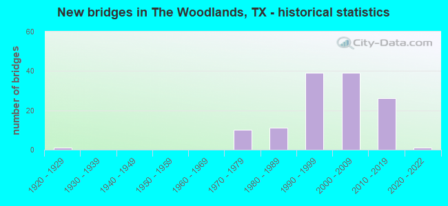
- New bridges - historical statistics
- 11920-1929
- 101970-1979
- 111980-1989
- 391990-1999
- 392000-2009
- 262010-2019
- 12020-2022
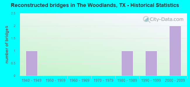
- Reconstructed bridges - Historical Statistics
- 11940-1949
- 01950-1959
- 01960-1969
- 01970-1979
- 11980-1989
- 11990-1999
- 22000-2009
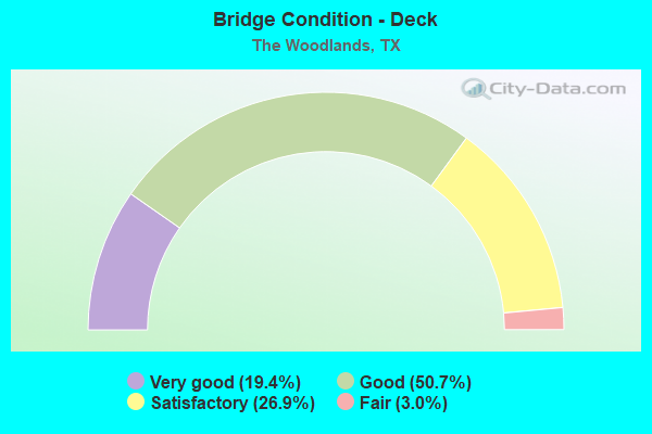
- Bridge Condition - Deck
- 19.4%Very good
- 50.7%Good
- 26.9%Satisfactory
- 3.0%Fair
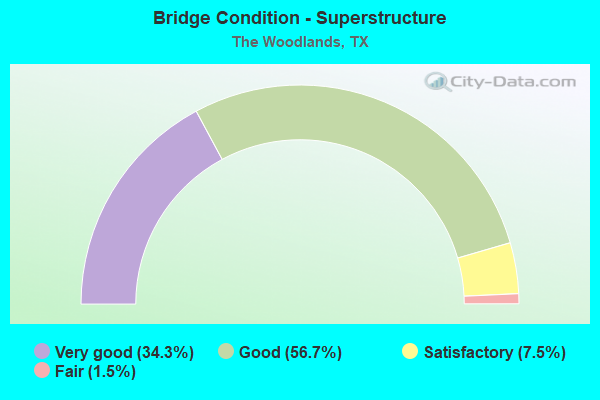
- Bridge Condition - Superstructure
- 34.3%Very good
- 56.7%Good
- 7.5%Satisfactory
- 1.5%Fair
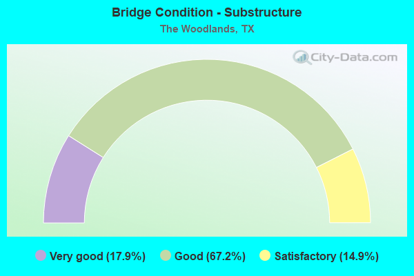
- Bridge Condition - Substructure
- 17.9%Very good
- 67.2%Good
- 14.9%Satisfactory
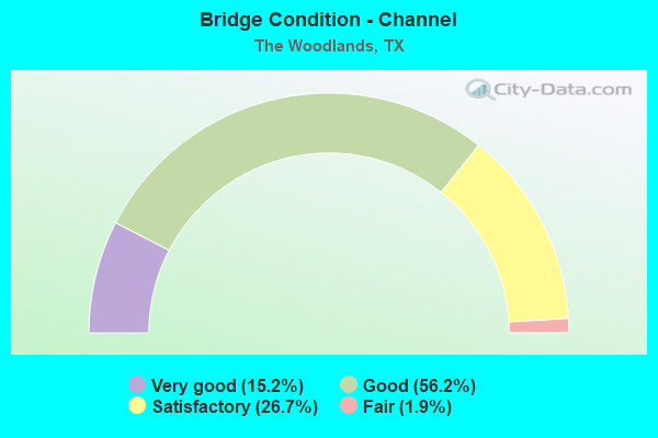
- Bridge Condition - Channel
- 15.2%Very good
- 56.2%Good
- 26.7%Satisfactory
- 1.9%Fair
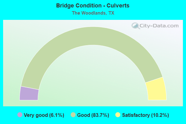
- Bridge Condition - Culverts
- 6.1%Very good
- 83.7%Good
- 10.2%Satisfactory
Find on map >> Show street view
Structure Number: 121020351006122, Location: 1.45 MI W OF IH 45 (Lat: 30.089556, Lng: -95.457211), Route carried "on" structure: County highway , Year Built: 2016, Status: Open, Structure Length: 1.28m (4.20ft), Average Daily Traffic: 50 (year 2016), Truck Traffic: 2%, Average Future Daily Traffic: 750 (year 2036), Design Load: HL 93, Features Intersected: SH 99 WB FRTG RD, Facility Carried by Structure: SPRINGWOODS VILLAG
Minimum Vertical Clearance: 30+ m (98+ ft), Kilometerpoint: 62.877, Lanes on structure: 6, Lanes under structure: 2, Owner: State Highway Agency, Approaching Roadway Width: 25.9m (85.0ft), Material/Design: Prestressed concrete, Design/Construction: Stringer/Multi-beam, Number Of Spans In Main Unit: 1, Length of Maximum Span: 12.8m (42.0ft), Curb or Sidewalk Widths: Left: 1.6m (5.2ft), Right: 1.6m (5.2ft), Curb-To-Curb Width: 25.9m (85.0ft), Out-to-Out Width: 30.2m (99.1ft)
Condition: Deck: Very good, Superstructure: Very good, Substructure: Good, Operating Rating: 54.4 metric tons, Method Used To Determine Operating Rating: Assigned ratings based on Load and Resistance Factor Design (LRFD) reported in metric tons, Inventory Rating: 32.7 metric tons, Method Used To Determine Inventory Rating: Assigned ratings based on Load and Resistance Factor Design (LRFD) reported in metric tons, Structural Evaluation: Better than present minimum criteria, Deck Geometry: Equal to present minimum criteria, Underclear: High priority of corrective action, Approach Roadway Alignment: Equal to present desirable criteria, Designated Inspection Frequency: Every 24 months, Inspection Date: December 2020, Deck Structure Type: Concrete Precast Panels
Find on map >> Show street view
Structure Number: 121020351006124, Location: 1.45 MI W OF IH 45 (Lat: 30.088931, Lng: -95.457508), Route carried "on" structure: County highway , Year Built: 2016, Status: Open, Structure Length: 3.99m (13.09ft), Average Daily Traffic: 50 (year 2016), Average Future Daily Traffic: 750 (year 2036), Design Load: HL 93, Features Intersected: SH 99, Facility Carried by Structure: SPRINGWOODS VILLAG
Minimum Vertical Clearance: 30+ m (98+ ft), Kilometerpoint: 0.000, Lanes on structure: 7, Lanes under structure: 4, Owner: State Highway Agency, Approaching Roadway Width: 25.9m (85.0ft), Material/Design: Prestressed concrete, Design/Construction: Stringer/Multi-beam, Number Of Spans In Main Unit: 2, Length of Maximum Span: 19.8m (65.0ft), Curb or Sidewalk Widths: Left: 0.0m, Right: 1.7m (5.6ft), Curb-To-Curb Width: 25.9m (85.0ft), Out-to-Out Width: 28.3m (92.8ft)
Condition: Deck: Very good, Superstructure: Very good, Substructure: Very good, Operating Rating: 54.4 metric tons, Method Used To Determine Operating Rating: Assigned ratings based on Load and Resistance Factor Design (LRFD) reported in metric tons, Inventory Rating: 32.7 metric tons, Method Used To Determine Inventory Rating: Assigned ratings based on Load and Resistance Factor Design (LRFD) reported in metric tons, Structural Evaluation: Equal to present desirable criteria, Deck Geometry: Meets minimum limits, Underclear: Meets minimum limits, Approach Roadway Alignment: Equal to present desirable criteria, Designated Inspection Frequency: Every 24 months, Inspection Date: December 2020, Deck Structure Type: Concrete Precast Panels
Find on map >> Show street view
Structure Number: 121020351006178, Location: 3.5 MI W OF IH 45 (Lat: 30.094350, Lng: -95.496353), Route carried "on" structure: Other road 99, Year Built: 2016, Status: Open, Structure Length: 57.03m (187.11ft), Average Daily Traffic: 6,000 (year 2016), Truck Traffic: 8%, Average Future Daily Traffic: 10,000 (year 2036), Design Load: HL 93, Features Intersected: ROTHWOOD RD; UP RAILROAD
Minimum Vertical Clearance: 30+ m (98+ ft), Kilometerpoint: 59.069, Lanes on structure: 4, Lanes under structure: 2, Toll: On toll road, Owner: State Highway Agency, Approaching Roadway Width: 23.2m (76.1ft), Skew: 39 degrees, Material/Design: Prestressed concrete, Design/Construction: Stringer/Multi-beam, Number Of Spans In Main Unit: 16, Length of Maximum Span: 40.8m (133.9ft), Curb-To-Curb Width: 23.2m (76.1ft), Out-to-Out Width: 24.4m (80.1ft)
Condition: Deck: Good, Superstructure: Good, Substructure: Very good, Operating Rating: 54.4 metric tons, Method Used To Determine Operating Rating: Assigned ratings based on Load and Resistance Factor Design (LRFD) reported in metric tons, Inventory Rating: 32.7 metric tons, Method Used To Determine Inventory Rating: Assigned ratings based on Load and Resistance Factor Design (LRFD) reported in metric tons, Structural Evaluation: Better than present minimum criteria, Deck Geometry: Superior to present desirable criteria, Underclear: Superior to present desirable criteria, Approach Roadway Alignment: Equal to present desirable criteria, Designated Inspection Frequency: Every 24 months, Inspection Date: December 2020, Deck Structure Type: Concrete Precast Panels
Find on map >> Show street view
Structure Number: 121020351006213, Location: 1.10 MI E OF GOSLING RD (Lat: 30.094172, Lng: -95.488783), Route carried "on" structure: Other road 99, Year Built: 2016, Status: Open, Structure Length: 1.16m (3.81ft), Average Daily Traffic: 4,000 (year 2016), Truck Traffic: 5%, Average Future Daily Traffic: 6,000 (year 2036), Design Load: HL 93, Features Intersected: HCFCD DITCH J121-00-00
Minimum Vertical Clearance: 30+ m (98+ ft), Kilometerpoint: 0.000, Lanes on structure: 4, Toll: On toll road, Owner: State Highway Agency, Approaching Roadway Width: 23.2m (76.1ft), Skew: 33 degrees, Material/Design: Concrete, Design/Construction: Culvert, Number Of Spans In Main Unit: 3, Length of Maximum Span: 2.7m (8.9ft)
Condition: Channel: Satisfactory, Culverts: Good, Operating Rating: 54.4 metric tons, Method Used To Determine Operating Rating: Assigned ratings based on Load and Resistance Factor Design (LRFD) reported in metric tons, Inventory Rating: 32.7 metric tons, Method Used To Determine Inventory Rating: Assigned ratings based on Load and Resistance Factor Design (LRFD) reported in metric tons, Structural Evaluation: Better than present minimum criteria, Waterway Adequacy: Superior to present desirable criteria, Approach Roadway Alignment: Equal to present desirable criteria, Designated Inspection Frequency: Every 24 months, Inspection Date: December 2020
Find on map >> Show street view
Structure Number: 121020351006214, Location: 1.15 MI E OF GOSLING RD (Lat: 30.094047, Lng: -95.487533), Route carried "on" structure: Other road 99, Year Built: 2016, Status: Open, Structure Length: 0.70m (2.30ft), Average Daily Traffic: 4,000 (year 2016), Truck Traffic: 5%, Average Future Daily Traffic: 6,000 (year 2036), Design Load: HL 93, Features Intersected: HCFCD DITCH J121-00-00
Minimum Vertical Clearance: 30+ m (98+ ft), Kilometerpoint: 0.000, Lanes on structure: 4, Toll: On toll road, Owner: State Highway Agency, Approaching Roadway Width: 23.2m (76.1ft), Skew: 31 degrees, Material/Design: Concrete, Design/Construction: Culvert, Number Of Spans In Main Unit: 2, Length of Maximum Span: 3.0m (9.8ft)
Condition: Channel: Good, Culverts: Good, Operating Rating: 54.4 metric tons, Method Used To Determine Operating Rating: Assigned ratings based on Load and Resistance Factor Design (LRFD) reported in metric tons, Inventory Rating: 32.7 metric tons, Method Used To Determine Inventory Rating: Assigned ratings based on Load and Resistance Factor Design (LRFD) reported in metric tons, Structural Evaluation: Better than present minimum criteria, Waterway Adequacy: Superior to present desirable criteria, Approach Roadway Alignment: Equal to present desirable criteria, Designated Inspection Frequency: Every 24 months, Inspection Date: December 2020
Find on map >> Show street view
Structure Number: 12102035100623, Location: 2.75 MI W OF IH 45 (Lat: 30.092636, Lng: -95.478047), Route carried "on" structure: Other road 99, Year Built: 2016, Status: Open, Structure Length: 2.16m (7.09ft), Average Daily Traffic: 4,000 (year 2016), Truck Traffic: 2%, Average Future Daily Traffic: 6,000 (year 2036), Design Load: HL 93, Features Intersected: MOSSY OAKS RD
Minimum Vertical Clearance: 30+ m (98+ ft), Kilometerpoint: 60.840, Lanes on structure: 2, Lanes under structure: 2, Toll: On toll road, Owner: State Highway Agency, Approaching Roadway Width: 11.6m (38.1ft), Skew: 1 degrees, Material/Design: Prestressed concrete, Design/Construction: Stringer/Multi-beam, Number Of Spans In Main Unit: 1, Length of Maximum Span: 21.3m (69.9ft), Curb-To-Curb Width: 11.5m (37.7ft), Out-to-Out Width: 12.2m (40.0ft)
Condition: Deck: Good, Superstructure: Very good, Substructure: Good, Operating Rating: 54.4 metric tons, Method Used To Determine Operating Rating: Assigned ratings based on Load and Resistance Factor Design (LRFD) reported in metric tons, Inventory Rating: 32.7 metric tons, Method Used To Determine Inventory Rating: Assigned ratings based on Load and Resistance Factor Design (LRFD) reported in metric tons, Structural Evaluation: Better than present minimum criteria, Deck Geometry: Somewhat better than minimum adequacy, Underclear: Superior to present desirable criteria, Approach Roadway Alignment: Equal to present desirable criteria, Designated Inspection Frequency: Every 24 months, Inspection Date: December 2020, Deck Structure Type: Concrete Precast Panels
Find on map >> Show street view
Structure Number: 121020351006231, Location: 2.75 MI W OF IH 45 (Lat: 30.092806, Lng: -95.477828), Route carried "on" structure: Other road 99, Year Built: 2016, Status: Open, Structure Length: 2.16m (7.09ft), Average Daily Traffic: 4,000 (year 2016), Truck Traffic: 2%, Average Future Daily Traffic: 6,000 (year 2036), Design Load: HL 93, Features Intersected: MOSSY OAKS RD
Minimum Vertical Clearance: 30+ m (98+ ft), Kilometerpoint: 60.856, Lanes on structure: 2, Lanes under structure: 2, Toll: On toll road, Owner: State Highway Agency, Approaching Roadway Width: 11.6m (38.1ft), Skew: 1 degrees, Material/Design: Prestressed concrete, Design/Construction: Stringer/Multi-beam, Number Of Spans In Main Unit: 1, Length of Maximum Span: 21.3m (69.9ft), Curb-To-Curb Width: 11.5m (37.7ft), Out-to-Out Width: 12.2m (40.0ft)
Condition: Deck: Good, Superstructure: Very good, Substructure: Good, Operating Rating: 54.4 metric tons, Method Used To Determine Operating Rating: Assigned ratings based on Load and Resistance Factor Design (LRFD) reported in metric tons, Inventory Rating: 32.7 metric tons, Method Used To Determine Inventory Rating: Assigned ratings based on Load and Resistance Factor Design (LRFD) reported in metric tons, Structural Evaluation: Better than present minimum criteria, Deck Geometry: Somewhat better than minimum adequacy, Underclear: Superior to present desirable criteria, Approach Roadway Alignment: Equal to present desirable criteria, Designated Inspection Frequency: Every 24 months, Inspection Date: December 2020, Deck Structure Type: Concrete Precast Panels
Find on map >> Show street view
Structure Number: 121020A30000001, Location: 0.3 MI SW OF CREEKSIDE FO (Lat: 30.145819, Lng: -95.527314), Route carried "on" structure: County highway , Year Built: 2009, Status: Open, Structure Length: 2.13m (6.99ft), Average Daily Traffic: 100 (year 2013), Average Future Daily Traffic: 150 (year 2033), Design Load: HL 93, Features Intersected: DRAINAGE DITCH, Facility Carried by Structure: LAKE PALOMA TRAIL
Minimum Vertical Clearance: 30+ m (98+ ft), Kilometerpoint: 0.483, Lanes on structure: 2, Owner: County Highway Agency, Approaching Roadway Width: 7.9m (25.9ft), Skew: 3 degrees, Material/Design: Prestressed concrete, Design/Construction: Stringer/Multi-beam, Number Of Spans In Main Unit: 1, Length of Maximum Span: 21.3m (69.9ft), Curb or Sidewalk Widths: Left: 0.0m, Right: 3.0m (9.8ft), Curb-To-Curb Width: 8.5m (27.9ft), Out-to-Out Width: 12.8m (42.0ft)
Condition: Deck: Good, Superstructure: Very good, Substructure: Good, Channel: Good, Operating Rating: 54.4 metric tons, Method Used To Determine Operating Rating: Assigned ratings based on Load and Resistance Factor Design (LRFD) reported in metric tons, Inventory Rating: 32.7 metric tons, Method Used To Determine Inventory Rating: Assigned ratings based on Load and Resistance Factor Design (LRFD) reported in metric tons, Structural Evaluation: Better than present minimum criteria, Deck Geometry: Better than present minimum criteria, Waterway Adequacy: Superior to present desirable criteria, Approach Roadway Alignment: Equal to present desirable criteria, Designated Inspection Frequency: Every 24 months, Inspection Date: October 2021, Deck Structure Type: Concrete Cast-file-Place
Find on map >> Show street view
Structure Number: 121020A45969019, Location: 0.6 MI E OF GOSLING RD (Lat: 30.102589, Lng: -95.497886), Route carried "on" structure: County highway , Year Built: 2013, Status: Open, Structure Length: 2.01m (6.59ft), Average Daily Traffic: 200 (year 2016), Truck Traffic: 1%, Average Future Daily Traffic: 1,000 (year 2033), Features Intersected: DRAW, Facility Carried by Structure: W MOSSY OAKS DR
Minimum Vertical Clearance: 30+ m (98+ ft), Kilometerpoint: 0.966, Lanes on structure: 2, Owner: County Highway Agency, Approaching Roadway Width: 11.0m (36.1ft), Material/Design: Prestressed concrete, Design/Construction: Stringer/Multi-beam, Number Of Spans In Main Unit: 1, Length of Maximum Span: 20.1m (65.9ft), Curb or Sidewalk Widths: Left: 0.0m, Right: 2.4m (7.9ft), Curb-To-Curb Width: 11.3m (37.1ft), Out-to-Out Width: 15.2m (49.9ft)
Condition: Deck: Very good, Superstructure: Very good, Substructure: Very good, Channel: Good, Operating Rating: 32.7 metric tons, Method Used To Determine Operating Rating: Field evaluation and documented engineering judgment, Inventory Rating: 24.5 metric tons, Method Used To Determine Inventory Rating: Field evaluation and documented engineering judgment, Structural Evaluation: Equal to present minimum criteria, Deck Geometry: Superior to present desirable criteria, Waterway Adequacy: Better than present minimum criteria, Approach Roadway Alignment: Equal to present desirable criteria, Designated Inspection Frequency: Every 24 months, Inspection Date: November 2021, Deck Structure Type: Concrete Cast-file-Place
Find on map >> Show street view
Structure Number: 121020A6085801, Location: 1.3 MI SW OF IH 45 (Lat: 30.095669, Lng: -95.453425), Route carried "on" structure: County highway , Year Built: 2015, Status: Open, Structure Length: 1.04m (3.41ft), Average Daily Traffic: 200 (year 2015), Truck Traffic: 1%, Average Future Daily Traffic: 1,000 (year 2035), Design Load: HS 20, Features Intersected: DRAW, Facility Carried by Structure: SPRINGWOODS VLG WB
Minimum Vertical Clearance: 30+ m (98+ ft), Kilometerpoint: 2.092, Lanes on structure: 2, Owner: County Highway Agency, Approaching Roadway Width: 7.6m (24.9ft), Material/Design: Concrete, Design/Construction: Arch - Deck, Number Of Spans In Main Unit: 1, Length of Maximum Span: 9.8m (32.2ft), Curb-To-Curb Width: 9.2m (30.2ft), Out-to-Out Width: 14.7m (48.2ft)
Condition: Deck: Good, Superstructure: Good, Substructure: Very good, Channel: Very good, Operating Rating: 54.4 metric tons, Method Used To Determine Operating Rating: Assigned rating based on Load Factor Design (LFD) reported in metric tons, Inventory Rating: 32.7 metric tons, Method Used To Determine Inventory Rating: Assigned rating based on Load Factor Design (LFD) reported in metric tons, Structural Evaluation: Better than present minimum criteria, Deck Geometry: Meets minimum limits, Waterway Adequacy: Better than present minimum criteria, Approach Roadway Alignment: Equal to present desirable criteria, Designated Inspection Frequency: Every 24 months, Inspection Date: November 2021, Deck Structure Type: Concrete Cast-file-Place
Find on map >> Show street view
Structure Number: 121020A60858011, Location: 1.3 MI SW OF IH 45 (Lat: 30.095417, Lng: -95.453244), Route carried "on" structure: County highway , Year Built: 2015, Status: Open, Structure Length: 1.04m (3.41ft), Average Daily Traffic: 200 (year 2015), Truck Traffic: 2%, Average Future Daily Traffic: 1,000 (year 2035), Design Load: HS 20, Features Intersected: DRAW, Facility Carried by Structure: SPRINGWOODS VLG EB
Minimum Vertical Clearance: 30+ m (98+ ft), Kilometerpoint: 2.092, Lanes on structure: 2, Owner: County Highway Agency, Approaching Roadway Width: 7.6m (24.9ft), Material/Design: Concrete, Design/Construction: Arch - Deck, Number Of Spans In Main Unit: 1, Length of Maximum Span: 9.8m (32.2ft), Curb-To-Curb Width: 9.2m (30.2ft), Out-to-Out Width: 14.7m (48.2ft)
Condition: Deck: Very good, Superstructure: Very good, Substructure: Very good, Channel: Good, Operating Rating: 54.4 metric tons, Method Used To Determine Operating Rating: Assigned rating based on Load Factor Design (LFD) reported in metric tons, Inventory Rating: 32.7 metric tons, Method Used To Determine Inventory Rating: Assigned rating based on Load Factor Design (LFD) reported in metric tons, Structural Evaluation: Equal to present desirable criteria, Deck Geometry: Meets minimum limits, Waterway Adequacy: Better than present minimum criteria, Approach Roadway Alignment: Equal to present desirable criteria, Designated Inspection Frequency: Every 24 months, Inspection Date: November 2021, Deck Structure Type: Concrete Cast-file-Place
Find on map >> Show street view
Structure Number: 121020AA0681004, Location: 7.70 MI N OF FM 2920 (Lat: 30.168481, Lng: -95.542506), Route carried "on" structure: County highway , Year Built: 1985, Status: Open, Structure Length: 34.20m (112.20ft), Average Daily Traffic: 6,000 (year 2013), Truck Traffic: 2%, Average Future Daily Traffic: 10,000 (year 2033), Features Intersected: SPRING CREEK, Facility Carried by Structure: KUYKENDAHL RD NB
Minimum Vertical Clearance: 30+ m (98+ ft), Kilometerpoint: 1.207, Lanes on structure: 2, Owner: County Highway Agency, Approaching Roadway Width: 7.3m (24.0ft), Material/Design: Prestressed concrete, Design/Construction: Stringer/Multi-beam, Number Of Spans In Main Unit: 11, Length of Maximum Span: 36.6m (120.1ft), Curb or Sidewalk Widths: Left: 1.8m (5.9ft), Right: 0.5m (1.6ft), Curb-To-Curb Width: 7.3m (24.0ft), Out-to-Out Width: 10.2m (33.5ft)
Condition: Deck: Fair, Superstructure: Good, Substructure: Good, Channel: Good, Operating Rating: 32.7 metric tons, Method Used To Determine Operating Rating: Field evaluation and documented engineering judgment, Inventory Rating: 24.5 metric tons, Method Used To Determine Inventory Rating: Field evaluation and documented engineering judgment, Structural Evaluation: Equal to present minimum criteria, Deck Geometry: High priority of replacement, Waterway Adequacy: Equal to present minimum criteria, Approach Roadway Alignment: Equal to present desirable criteria, Length Of Structure Improvement: 34.20m (112.20ft), Designated Inspection Frequency: Every 24 months, Inspection Date: October 2021, Bridge Improvement Cost: $54,000, Roadway Improvement Cost: $14,000, Total Project Cost: $68,000, Deck Structure Type: Concrete Cast-file-Place
Find on map >> Show street view
Structure Number: 121020AA0681005, Location: 7.70 MI N OF FM 2920 (Lat: 30.168517, Lng: -95.542875), Route carried "on" structure: County highway , Year Built: 2017, Status: Open, Structure Length: 34.14m (112.01ft), Average Daily Traffic: 3,000 (year 2013), Truck Traffic: 2%, Average Future Daily Traffic: 5,000 (year 2033), Design Load: HL 93, Features Intersected: SPRING CREEK, Facility Carried by Structure: KUYKENDAHL RD SB
Minimum Vertical Clearance: 30+ m (98+ ft), Kilometerpoint: 1.207, Lanes on structure: 2, Owner: County Highway Agency, Approaching Roadway Width: 7.3m (24.0ft), Material/Design: Prestressed concrete, Design/Construction: Stringer/Multi-beam, Number Of Spans In Main Unit: 11, Length of Maximum Span: 36.6m (120.1ft), Curb or Sidewalk Widths: Left: 2.4m (7.9ft), Right: 0.5m (1.6ft), Curb-To-Curb Width: 7.6m (24.9ft), Out-to-Out Width: 11.4m (37.4ft)
Condition: Deck: Good, Superstructure: Very good, Substructure: Good, Channel: Good, Operating Rating: 54.4 metric tons, Method Used To Determine Operating Rating: Assigned ratings based on Load and Resistance Factor Design (LRFD) reported in metric tons, Inventory Rating: 32.7 metric tons, Method Used To Determine Inventory Rating: Assigned ratings based on Load and Resistance Factor Design (LRFD) reported in metric tons, Structural Evaluation: Better than present minimum criteria, Deck Geometry: High priority of replacement, Waterway Adequacy: Superior to present desirable criteria, Approach Roadway Alignment: Equal to present desirable criteria, Designated Inspection Frequency: Every 24 months, Inspection Date: October 2021, Deck Structure Type: Concrete Precast Panels
Find on map >> Show street view
Structure Number: 121020AA0759001, Location: 1.20 MI N OF ROOT RD (Lat: 30.114936, Lng: -95.506778), Route carried "on" structure: County highway , Year Built: 1997, Status: Open, Structure Length: 7.62m (25.00ft), Average Daily Traffic: 460 (year 2013), Truck Traffic: 1%, Average Future Daily Traffic: 5,000 (year 2033), Features Intersected: WILLOW CREEK, Facility Carried by Structure: GOSLING RD
Minimum Vertical Clearance: 30+ m (98+ ft), Kilometerpoint: 4.345, Lanes on structure: 2, Owner: County Highway Agency, Approaching Roadway Width: 10.4m (34.1ft), Skew: 1 degrees, Material/Design: Prestressed concrete, Design/Construction: Box Beam or Girders - Multiple, Number Of Spans In Main Unit: 5, Length of Maximum Span: 15.2m (49.9ft), Curb-To-Curb Width: 25.3m (83.0ft), Out-to-Out Width: 32.1m (105.3ft)
Condition: Deck: Good, Superstructure: Good, Substructure: Good, Channel: Good, Operating Rating: 32.7 metric tons, Method Used To Determine Operating Rating: Field evaluation and documented engineering judgment, Inventory Rating: 24.5 metric tons, Method Used To Determine Inventory Rating: Field evaluation and documented engineering judgment, Structural Evaluation: Equal to present minimum criteria, Deck Geometry: Superior to present desirable criteria, Waterway Adequacy: Better than present minimum criteria, Approach Roadway Alignment: Equal to present desirable criteria, Designated Inspection Frequency: Every 24 months, Inspection Date: October 2021, Deck Structure Type: Concrete Cast-file-Place
Find on map >> Show street view
Structure Number: 121020AA0759002, Location: 4.6 MI N OF FM 2920 (Lat: 30.143006, Lng: -95.504633), Route carried "on" structure: County highway , Year Built: 2002, Status: Open, Structure Length: 56.36m (184.91ft), Average Daily Traffic: 24,991 (year 2016), Truck Traffic: 2%, Average Future Daily Traffic: 11,700 (year 2033), Design Load: HS 20, Features Intersected: SPRING CREEK, Facility Carried by Structure: GOSLING RD
Minimum Vertical Clearance: 30+ m (98+ ft), Kilometerpoint: 7.403, Lanes on structure: 2, Owner: County Highway Agency, Approaching Roadway Width: 9.8m (32.2ft), Material/Design: Prestressed concrete, Design/Construction: Stringer/Multi-beam, Number Of Spans In Main Unit: 17, Length of Maximum Span: 35.7m (117.1ft), Curb or Sidewalk Widths: Left: 0.0m, Right: 2.4m (7.9ft), Curb-To-Curb Width: 9.8m (32.2ft), Out-to-Out Width: 13.4m (44.0ft)
Condition: Deck: Good, Superstructure: Very good, Substructure: Good, Channel: Good, Operating Rating: 54.4 metric tons, Method Used To Determine Operating Rating: Assigned rating based on Load Factor Design (LFD) reported in metric tons, Inventory Rating: 32.7 metric tons, Method Used To Determine Inventory Rating: Assigned rating based on Load Factor Design (LFD) reported in metric tons, Structural Evaluation: Better than present minimum criteria, Deck Geometry: Meets minimum limits, Waterway Adequacy: Superior to present desirable criteria, Approach Roadway Alignment: Equal to present desirable criteria, Designated Inspection Frequency: Every 24 months, Inspection Date: October 2021, Deck Structure Type: Concrete Precast Panels
Find on map >> Show street view
Structure Number: 121020AA0762002, Location: 0.5 MI NW OF GOSLING RD (Lat: 30.128175, Lng: -95.513769), Route carried "on" structure: County highway , Year Built: 2004, Status: Open, Structure Length: 0.70m (2.30ft), Average Daily Traffic: 2,000 (year 2013), Truck Traffic: 2%, Average Future Daily Traffic: 4,000 (year 2033), Features Intersected: DRAINAGE DITCH, Facility Carried by Structure: WEST RAYFORD RD
Minimum Vertical Clearance: 30+ m (98+ ft), Kilometerpoint: 0.805, Lanes on structure: 4, Owner: County Highway Agency, Approaching Roadway Width: 14.6m (47.9ft), Skew: 1 degrees, Material/Design: Concrete, Design/Construction: Culvert, Number Of Spans In Main Unit: 2, Length of Maximum Span: 3.0m (9.8ft)
Condition: Channel: Good, Culverts: Good, Operating Rating: 32.7 metric tons, Method Used To Determine Operating Rating: Field evaluation and documented engineering judgment, Inventory Rating: 24.5 metric tons, Method Used To Determine Inventory Rating: Field evaluation and documented engineering judgment, Structural Evaluation: Equal to present minimum criteria, Waterway Adequacy: Better than present minimum criteria, Approach Roadway Alignment: Equal to present desirable criteria, Designated Inspection Frequency: Every 24 months, Inspection Date: October 2021
Find on map >> Show street view
Structure Number: 121020AA8384001, Location: 0.7 MI S OF WEST RAYFORD (Lat: 30.120381, Lng: -95.518633), Route carried "on" structure: County highway , Year Built: 1988, Status: Open, Structure Length: 5.36m (17.59ft), Average Daily Traffic: 2,000 (year 2013), Truck Traffic: 2%, Average Future Daily Traffic: 3,000 (year 2033), Features Intersected: WILLOW CREEK, Facility Carried by Structure: NORTHCREST DR
Minimum Vertical Clearance: 30+ m (98+ ft), Kilometerpoint: 1.127, Lanes on structure: 2, Owner: County Highway Agency, Approaching Roadway Width: 8.2m (26.9ft), Material/Design: Prestressed concrete, Design/Construction: Box Beam or Girders - Multiple, Number Of Spans In Main Unit: 5, Length of Maximum Span: 10.7m (35.1ft), Curb or Sidewalk Widths: Left: 1.0m (3.3ft), Right: 0.5m (1.6ft), Curb-To-Curb Width: 8.2m (26.9ft), Out-to-Out Width: 10.3m (33.8ft)
Condition: Deck: Fair, Superstructure: Good, Substructure: Satisfactory, Channel: Satisfactory, Operating Rating: 32.7 metric tons, Method Used To Determine Operating Rating: Field evaluation and documented engineering judgment, Inventory Rating: 24.5 metric tons, Method Used To Determine Inventory Rating: Field evaluation and documented engineering judgment, Structural Evaluation: Equal to present minimum criteria, Deck Geometry: Meets minimum limits, Waterway Adequacy: Equal to present desirable criteria, Approach Roadway Alignment: Equal to present desirable criteria, Designated Inspection Frequency: Every 24 months, Inspection Date: October 2021, Deck Structure Type: Concrete Cast-file-Place
Find on map >> Show street view
Structure Number: 121700011002001, Location: 0.2 MI S OF WALKER C/L (Lat: 30.505975, Lng: -95.484667), Route carried "on" structure: State highway 75, Year Built: 1928, Year Reconstructed: 1951, Status: Open, Structure Length: 5.67m (18.60ft), Average Daily Traffic: 5,188 (year 2019), Truck Traffic: 8%, Average Future Daily Traffic: 4,430 (year 2033), Design Load: H 15, Features Intersected: LITTLE CANEY CREEK
Minimum Vertical Clearance: 30+ m (98+ ft), Kilometerpoint: 1.947, Lanes on structure: 2, Owner: State Highway Agency, Approaching Roadway Width: 7.9m (25.9ft), Material/Design: Concrete, Design/Construction: Tee Beam, Number Of Spans In Main Unit: 7, Length of Maximum Span: 8.2m (26.9ft), Curb-To-Curb Width: 8.0m (26.2ft), Out-to-Out Width: 9.4m (30.8ft)
Condition: Deck: Satisfactory, Superstructure: Fair, Substructure: Satisfactory, Channel: Satisfactory, Operating Rating: 66.2 metric tons, Method Used To Determine Operating Rating: Load Factor (LF), Inventory Rating: 39.0 metric tons, Method Used To Determine Inventory Rating: Load Factor (LF), Structural Evaluation: Somewhat better than minimum adequacy, Deck Geometry: High priority of replacement, Waterway Adequacy: Equal to present minimum criteria, Approach Roadway Alignment: Equal to present desirable criteria, Length Of Structure Improvement: 5.67m (18.60ft), Designated Inspection Frequency: Every 24 months, Inspection Date: October 2020, Bridge Improvement Cost: $10,000, Roadway Improvement Cost: $3,000, Total Project Cost: $13,000, Deck Structure Type: Concrete Cast-file-Place, Wearing Surface/Protective System: Wearing Surface: Bituminous
Find on map >> Show street view
Structure Number: 121700011004135, Location: 2.1 MI S OF FM 1488 (Lat: 30.207144, Lng: -95.456317), Route carried "on" structure: Interstate 45, Year Built: 1991, Status: Open, Structure Length: 10.67m (35.01ft), Average Daily Traffic: 90,334 (year 2017), Truck Traffic: 8%, Average Future Daily Traffic: 110,840 (year 2033), Features Intersected: SH 242
Minimum Vertical Clearance: 30+ m (98+ ft), Kilometerpoint: 10.926, Lanes on structure: 4, Lanes under structure: 10, Owner: State Highway Agency, Approaching Roadway Width: 21.3m (69.9ft), Material/Design: Prestressed concrete, Design/Construction: Stringer/Multi-beam, Number Of Spans In Main Unit: 4, Length of Maximum Span: 27.4m (89.9ft), Curb-To-Curb Width: 21.3m (69.9ft), Out-to-Out Width: 22.2m (72.8ft)
Condition: Deck: Satisfactory, Superstructure: Good, Substructure: Satisfactory, Operating Rating: 68.0 metric tons, Method Used To Determine Operating Rating: Load Factor (LF), Inventory Rating: 32.7 metric tons, Method Used To Determine Inventory Rating: Load Factor (LF), Structural Evaluation: Equal to present minimum criteria, Deck Geometry: Better than present minimum criteria, Underclear: Meets minimum limits, Approach Roadway Alignment: Equal to present desirable criteria, Designated Inspection Frequency: Every 24 months, Inspection Date: August 2020, Deck Structure Type: Concrete Cast-file-Place
Find on map >> Show street view
Structure Number: 121700011004174, Location: 1.0 MI S OF FM 1488 (Lat: 30.221614, Lng: -95.456914), Route carried "on" structure: Interstate 45, Year Built: 2000, Status: Open, Structure Length: 2.19m (7.19ft), Average Daily Traffic: 163,343 (year 2020), Truck Traffic: 8%, Average Future Daily Traffic: 221,690 (year 2033), Design Load: HS 20, Features Intersected: DRAIN
Minimum Vertical Clearance: 30+ m (98+ ft), Kilometerpoint: 11.180, Lanes on structure: 16, Owner: State Highway Agency, Approaching Roadway Width: 73.2m (240.2ft), Skew: 30 degrees, Material/Design: Concrete, Design/Construction: Culvert, Number Of Spans In Main Unit: 5, Length of Maximum Span: 3.7m (12.1ft), Curb-To-Curb Width: 73.2m (240.2ft), Out-to-Out Width: 109.7m (359.9ft)
Condition: Channel: Good, Culverts: Satisfactory, Operating Rating: 54.4 metric tons, Method Used To Determine Operating Rating: Assigned rating based on Load Factor Design (LFD) reported in metric tons, Inventory Rating: 32.7 metric tons, Method Used To Determine Inventory Rating: Assigned rating based on Load Factor Design (LFD) reported in metric tons, Structural Evaluation: Equal to present minimum criteria, Deck Geometry: Superior to present desirable criteria, Waterway Adequacy: Equal to present minimum criteria, Approach Roadway Alignment: Equal to present desirable criteria, Designated Inspection Frequency: Every 24 months, Inspection Date: August 2020, Deck Structure Type: Concrete Precast Panels, Wearing Surface/Protective System: Wearing Surface: Monolithic Concrete
Find on map >> Show street view
Structure Number: 121700011004199, Location: 3.55 MI S OF SH 242 (Lat: 30.155636, Lng: -95.450331), Route carried "on" structure: Ramp Interstate 45, Year Built: 2004, Status: Open, Structure Length: 26.49m (86.91ft), Average Daily Traffic: 19,160 (year 2012), Truck Traffic: 6%, Average Future Daily Traffic: 33,620 (year 2032), Design Load: HS 20, Features Intersected: IH 45 SBFR
Minimum Vertical Clearance: 30+ m (98+ ft), Kilometerpoint: 4.973, Lanes on structure: 1, Lanes under structure: 3, Owner: State Highway Agency, Approaching Roadway Width: 7.9m (25.9ft), Material/Design: Prestressed concrete, Design/Construction: Stringer/Multi-beam, Number Of Spans In Main Unit: 5, Number Of Approach Spans: 3, Length of Maximum Span: 38.7m (127.0ft), Curb-To-Curb Width: 7.9m (25.9ft), Out-to-Out Width: 8.8m (28.9ft)
Condition: Deck: Satisfactory, Superstructure: Very good, Substructure: Satisfactory, Operating Rating: 54.4 metric tons, Method Used To Determine Operating Rating: Assigned rating based on Load Factor Design (LFD) reported in metric tons, Inventory Rating: 32.7 metric tons, Method Used To Determine Inventory Rating: Assigned rating based on Load Factor Design (LFD) reported in metric tons, Structural Evaluation: Equal to present minimum criteria, Deck Geometry: Equal to present desirable criteria, Underclear: High priority of corrective action, Approach Roadway Alignment: Equal to present desirable criteria, Designated Inspection Frequency: Every 24 months, Inspection Date: August 2020, Deck Structure Type: Concrete Cast-file-Place
Find on map >> Show street view
Structure Number: 121700011004307, Location: JCT IH 45 and SH 242 (Lat: 30.207014, Lng: -95.456794), Route carried "on" structure: Ramp Interstate 45, Year Built: 2014, Status: Open, Structure Length: 63.64m (208.79ft), Average Daily Traffic: 4,650 (year 2018), Truck Traffic: 10%, Average Future Daily Traffic: 1 (year 1900), Design Load: HL 93, Features Intersected: IH 45 ML & SH242
Minimum Vertical Clearance: 30+ m (98+ ft), Kilometerpoint: 0.000, Lanes on structure: 1, Lanes under structure: 25, Base Highway Network: Yes, Toll: On toll road, Owner: State Highway Agency, Approaching Roadway Width: 7.9m (25.9ft), Skew: 9 degrees, Material/Design: Steel continuous, Design/Construction: Stringer/Multi-beam, Number Of Spans In Main Unit: 6, Number Of Approach Spans: 6, Length of Maximum Span: 94.8m (311.0ft), Curb-To-Curb Width: 7.9m (25.9ft), Out-to-Out Width: 8.7m (28.5ft)
Condition: Deck: Good, Superstructure: Very good, Substructure: Very good, Operating Rating: 54.4 metric tons, Method Used To Determine Operating Rating: Assigned ratings based on Load and Resistance Factor Design (LRFD) reported in metric tons, Inventory Rating: 32.7 metric tons, Method Used To Determine Inventory Rating: Assigned ratings based on Load and Resistance Factor Design (LRFD) reported in metric tons, Structural Evaluation: Equal to present desirable criteria, Deck Geometry: Equal to present desirable criteria, Underclear: Meets minimum limits, Approach Roadway Alignment: Equal to present desirable criteria, Designated Inspection Frequency: Every 24 months, Inspection Date: November 2020, Deck Structure Type: Concrete Cast-file-Place
Find on map >> Show street view
Structure Number: 12170005231017, Location: 3.35 MI W OF SH 242 (Lat: 30.221600, Lng: -95.566367), Route carried "on" structure: State highway 1488, Year Built: 2007, Status: Open, Structure Length: 0.76m (2.49ft), Average Daily Traffic: 21,000 (year 2016), Truck Traffic: 7%, Average Future Daily Traffic: 43,000 (year 2036), Design Load: HS 20, Features Intersected: DRAINAGE DITCH
Minimum Vertical Clearance: 30+ m (98+ ft), Kilometerpoint: 27.069, Lanes on structure: 5, Owner: State Highway Agency, Approaching Roadway Width: 26.8m (87.9ft), Skew: 4 degrees, Material/Design: Concrete, Design/Construction: Culvert, Number Of Spans In Main Unit: 2, Length of Maximum Span: 3.0m (9.8ft), Curb-To-Curb Width: 26.8m (87.9ft), Out-to-Out Width: 36.6m (120.1ft)
Condition: Channel: Satisfactory, Culverts: Good, Operating Rating: 54.4 metric tons, Method Used To Determine Operating Rating: Assigned rating based on Load Factor Design (LFD) reported in metric tons, Inventory Rating: 32.7 metric tons, Method Used To Determine Inventory Rating: Assigned rating based on Load Factor Design (LFD) reported in metric tons, Structural Evaluation: Better than present minimum criteria, Deck Geometry: Superior to present desirable criteria, Waterway Adequacy: Equal to present minimum criteria, Approach Roadway Alignment: Equal to present desirable criteria, Designated Inspection Frequency: Every 48 months, Inspection Date: December 2020, Deck Structure Type: Concrete Cast-file-Place, Wearing Surface/Protective System: Wearing Surface: Monolithic Concrete
Find on map >> Show street view
Structure Number: 121700052310171, Location: 2.30 MI W OF SH 242 (Lat: 30.224289, Lng: -95.549256), Route carried "on" structure: State highway 1488, Year Built: 2007, Status: Open, Structure Length: 0.98m (3.22ft), Average Daily Traffic: 21,000 (year 2016), Truck Traffic: 7%, Average Future Daily Traffic: 43,000 (year 2036), Design Load: HS 20, Features Intersected: DRAW
Minimum Vertical Clearance: 30+ m (98+ ft), Kilometerpoint: 24.398, Lanes on structure: 5, Owner: State Highway Agency, Approaching Roadway Width: 25.6m (84.0ft), Skew: 9 degrees, Material/Design: Concrete, Design/Construction: Culvert, Number Of Spans In Main Unit: 4, Length of Maximum Span: 1.2m (3.9ft)
Condition: Channel: Good, Culverts: Good, Operating Rating: 54.4 metric tons, Method Used To Determine Operating Rating: Assigned rating based on Load Factor Design (LFD) reported in metric tons, Inventory Rating: 32.7 metric tons, Method Used To Determine Inventory Rating: Assigned rating based on Load Factor Design (LFD) reported in metric tons, Structural Evaluation: Better than present minimum criteria, Waterway Adequacy: Equal to present minimum criteria, Approach Roadway Alignment: Equal to present desirable criteria, Designated Inspection Frequency: Every 48 months, Inspection Date: December 2020
Find on map >> Show street view
Structure Number: 121700052310172, Location: 1.95 MI W OF SH 242 (Lat: 30.224400, Lng: -95.543300), Route carried "on" structure: State highway 1488, Year Built: 2007, Status: Open, Structure Length: 0.79m (2.59ft), Average Daily Traffic: 21,000 (year 2016), Truck Traffic: 7%, Average Future Daily Traffic: 43,000 (year 2036), Design Load: HS 20, Features Intersected: DRAW
Minimum Vertical Clearance: 30+ m (98+ ft), Kilometerpoint: 29.371, Lanes on structure: 5, Owner: State Highway Agency, Approaching Roadway Width: 25.6m (84.0ft), Material/Design: Concrete, Design/Construction: Culvert, Number Of Spans In Main Unit: 3, Length of Maximum Span: 2.1m (6.9ft)
Condition: Channel: Good, Culverts: Good, Operating Rating: 54.4 metric tons, Method Used To Determine Operating Rating: Assigned rating based on Load Factor Design (LFD) reported in metric tons, Inventory Rating: 32.7 metric tons, Method Used To Determine Inventory Rating: Assigned rating based on Load Factor Design (LFD) reported in metric tons, Structural Evaluation: Better than present minimum criteria, Waterway Adequacy: Equal to present minimum criteria, Approach Roadway Alignment: Equal to present desirable criteria, Designated Inspection Frequency: Every 48 months, Inspection Date: December 2020
Find on map >> Show street view
Structure Number: 121700052310173, Location: 0.30 MI W OF SH 242 (Lat: 30.228767, Lng: -95.516408), Route carried "on" structure: State highway 1488, Year Built: 2007, Status: Open, Structure Length: 0.91m (2.99ft), Average Daily Traffic: 21,000 (year 2016), Truck Traffic: 7%, Average Future Daily Traffic: 43,000 (year 2036), Design Load: HS 20, Features Intersected: PANTHER BR
Minimum Vertical Clearance: 30+ m (98+ ft), Kilometerpoint: 31.971, Lanes on structure: 5, Owner: State Highway Agency, Approaching Roadway Width: 25.6m (84.0ft), Material/Design: Concrete, Design/Construction: Culvert, Number Of Spans In Main Unit: 3, Length of Maximum Span: 2.4m (7.9ft)
Condition: Channel: Good, Culverts: Good, Operating Rating: 54.4 metric tons, Method Used To Determine Operating Rating: Assigned rating based on Load Factor Design (LFD) reported in metric tons, Inventory Rating: 32.7 metric tons, Method Used To Determine Inventory Rating: Assigned rating based on Load Factor Design (LFD) reported in metric tons, Structural Evaluation: Better than present minimum criteria, Waterway Adequacy: Equal to present minimum criteria, Approach Roadway Alignment: Equal to present desirable criteria, Designated Inspection Frequency: Every 48 months, Inspection Date: December 2020
Find on map >> Show street view
Structure Number: 121700052310174, Location: 0.25 MI W OF SH 242 (Lat: 30.228967, Lng: -95.515364), Route carried "on" structure: State highway 1488, Year Built: 2007, Status: Open, Structure Length: 0.88m (2.89ft), Average Daily Traffic: 21,000 (year 2016), Truck Traffic: 7%, Average Future Daily Traffic: 43,000 (year 2036), Design Load: HS 20, Features Intersected: PANTHER BRANCH RELIEF
Minimum Vertical Clearance: 30+ m (98+ ft), Kilometerpoint: 32.076, Lanes on structure: 5, Owner: State Highway Agency, Approaching Roadway Width: 25.6m (84.0ft), Material/Design: Concrete, Design/Construction: Culvert, Number Of Spans In Main Unit: 3, Length of Maximum Span: 2.4m (7.9ft)
Condition: Channel: Good, Culverts: Good, Operating Rating: 54.4 metric tons, Method Used To Determine Operating Rating: No rating analysis performed, Inventory Rating: 32.7 metric tons, Method Used To Determine Inventory Rating: No rating analysis performed, Structural Evaluation: Better than present minimum criteria, Waterway Adequacy: Equal to present minimum criteria, Approach Roadway Alignment: Equal to present desirable criteria, Designated Inspection Frequency: Every 48 months, Inspection Date: September 2020
Find on map >> Show street view
Structure Number: 121700052310179, Location: 0.4 MI W OF FM 2978 (Lat: 30.220725, Lng: -95.574819), Route carried "on" structure: State highway 1488, Year Built: 2010, Status: Open, Structure Length: 0.79m (2.59ft), Average Daily Traffic: 31,665 (year 2020), Truck Traffic: 7%, Average Future Daily Traffic: 43,000 (year 2028), Features Intersected: NICKABURR CREEK
Minimum Vertical Clearance: 30+ m (98+ ft), Kilometerpoint: 0.002, Lanes on structure: 5, Owner: State Highway Agency, Approaching Roadway Width: 25.6m (84.0ft), Material/Design: Concrete, Design/Construction: Culvert, Number Of Spans In Main Unit: 3, Length of Maximum Span: 2.1m (6.9ft), Curb-To-Curb Width: 25.6m (84.0ft), Out-to-Out Width: 26.2m (86.0ft)
Condition: Channel: Good, Culverts: Very good, Operating Rating: 44.4 metric tons, Method Used To Determine Operating Rating: No rating analysis performed, Inventory Rating: 32.7 metric tons, Method Used To Determine Inventory Rating: No rating analysis performed, Structural Evaluation: Equal to present desirable criteria, Deck Geometry: Superior to present desirable criteria, Waterway Adequacy: Equal to present minimum criteria, Approach Roadway Alignment: Equal to present desirable criteria, Designated Inspection Frequency: Every 48 months, Inspection Date: October 2020, Deck Structure Type: Concrete Cast-file-Place, Wearing Surface/Protective System: Wearing Surface: Monolithic Concrete
Find on map >> Show street view
Structure Number: 12170005231018, Location: 1.5 MI W OF FM 2978 (Lat: 30.221061, Lng: -95.593117), Route carried "on" structure: State highway 1488, Year Built: 2010, Status: Open, Structure Length: 1.19m (3.90ft), Average Daily Traffic: 31,665 (year 2020), Truck Traffic: 7%, Average Future Daily Traffic: 43,000 (year 2028), Features Intersected: BEAR BRANCH CREEK
Minimum Vertical Clearance: 30+ m (98+ ft), Kilometerpoint: 0.002, Lanes on structure: 5, Owner: State Highway Agency, Approaching Roadway Width: 25.6m (84.0ft), Skew: 1 degrees, Material/Design: Concrete, Design/Construction: Culvert, Number Of Spans In Main Unit: 4, Length of Maximum Span: 2.1m (6.9ft), Curb-To-Curb Width: 25.6m (84.0ft), Out-to-Out Width: 30.5m (100.1ft)
Condition: Channel: Good, Culverts: Good, Operating Rating: 44.4 metric tons, Method Used To Determine Operating Rating: No rating analysis performed, Inventory Rating: 32.7 metric tons, Method Used To Determine Inventory Rating: No rating analysis performed, Structural Evaluation: Better than present minimum criteria, Deck Geometry: Superior to present desirable criteria, Waterway Adequacy: Equal to present minimum criteria, Approach Roadway Alignment: Equal to present desirable criteria, Designated Inspection Frequency: Every 48 months, Inspection Date: December 2020
Find on map >> Show street view
Structure Number: 121700052310181, Location: 2.1 MI W OF FM 2978 (Lat: 30.221375, Lng: -95.602072), Route carried "on" structure: State highway 1488, Year Built: 2010, Status: Open, Structure Length: 0.70m (2.30ft), Average Daily Traffic: 31,665 (year 2020), Truck Traffic: 7%, Average Future Daily Traffic: 43,000 (year 2028), Features Intersected: OUTFALL 12
Minimum Vertical Clearance: 30+ m (98+ ft), Kilometerpoint: 0.002, Lanes on structure: 5, Owner: State Highway Agency, Approaching Roadway Width: 25.6m (84.0ft), Material/Design: Concrete, Design/Construction: Culvert, Number Of Spans In Main Unit: 4, Length of Maximum Span: 1.2m (3.9ft)
Condition: Channel: Good, Culverts: Very good, Operating Rating: 44.4 metric tons, Method Used To Determine Operating Rating: No rating analysis performed, Inventory Rating: 32.7 metric tons, Method Used To Determine Inventory Rating: No rating analysis performed, Structural Evaluation: Equal to present desirable criteria, Waterway Adequacy: Equal to present desirable criteria, Approach Roadway Alignment: Equal to present desirable criteria, Designated Inspection Frequency: Every 48 months, Inspection Date: December 2020
Find on map >> Show street view
Structure Number: 121700305002002, Location: 1.3 MI S OF FM 1488 (Lat: 30.205992, Lng: -95.578186), Route carried "on" structure: State highway 2978, Year Built: 1977, Status: Open, Structure Length: 1.01m (3.31ft), Average Daily Traffic: 23,400 (year 2020), Truck Traffic: 9%, Average Future Daily Traffic: 24,790 (year 2033), Design Load: HS 20, Features Intersected: BEAR BRANCH
Minimum Vertical Clearance: 30+ m (98+ ft), Kilometerpoint: 10.458, Lanes on structure: 2, Owner: State Highway Agency, Approaching Roadway Width: 7.3m (24.0ft), Material/Design: Concrete, Design/Construction: Culvert, Number Of Spans In Main Unit: 5, Length of Maximum Span: 1.8m (5.9ft), Curb-To-Curb Width: 7.3m (24.0ft), Out-to-Out Width: 22.3m (73.2ft)
Condition: Channel: Satisfactory, Culverts: Satisfactory, Operating Rating: 39.9 metric tons, Method Used To Determine Operating Rating: Load Factor (LF), Inventory Rating: 23.6 metric tons, Method Used To Determine Inventory Rating: Load Factor (LF), Structural Evaluation: Somewhat better than minimum adequacy, Deck Geometry: High priority of replacement, Waterway Adequacy: Equal to present minimum criteria, Approach Roadway Alignment: Equal to present desirable criteria, Designated Inspection Frequency: Every 48 months, Inspection Date: October 2020, Deck Structure Type: Concrete Cast-file-Place, Wearing Surface/Protective System: Wearing Surface: Bituminous
Find on map >> Show street view
Structure Number: 121700305002003, Location: 3.90 MI S OF FM 1488 (Lat: 30.175569, Lng: -95.600917), Route carried "on" structure: State highway 2978, Year Built: 1977, Status: Open, Structure Length: 8.66m (28.41ft), Average Daily Traffic: 18,053 (year 2020), Truck Traffic: 9%, Average Future Daily Traffic: 32,780 (year 2033), Design Load: HS 20, Features Intersected: DRY CREEK
Minimum Vertical Clearance: 30+ m (98+ ft), Kilometerpoint: 14.436, Lanes on structure: 2, Owner: State Highway Agency, Approaching Roadway Width: 11.0m (36.1ft), Material/Design: Concrete, Design/Construction: Stringer/Multi-beam, Number Of Spans In Main Unit: 7, Length of Maximum Span: 12.5m (41.0ft), Curb-To-Curb Width: 11.5m (37.7ft), Out-to-Out Width: 15.2m (49.9ft)
Condition: Deck: Satisfactory, Superstructure: Satisfactory, Substructure: Satisfactory, Channel: Satisfactory, Operating Rating: 68.0 metric tons, Method Used To Determine Operating Rating: Load Factor (LF), Inventory Rating: 40.8 metric tons, Method Used To Determine Inventory Rating: Load Factor (LF), Structural Evaluation: Equal to present minimum criteria, Deck Geometry: Meets minimum limits, Waterway Adequacy: Equal to present minimum criteria, Approach Roadway Alignment: Equal to present desirable criteria, Designated Inspection Frequency: Every 24 months, Inspection Date: August 2020, Deck Structure Type: Concrete Cast-file-Place
Find on map >> Show street view
Structure Number: 121700305002005, Location: 5.8 MI S OF FM 1488 (Lat: 30.148036, Lng: -95.597128), Route carried "on" structure: State highway 2978, Year Built: 2020, Status: Open, Structure Length: 0.91m (2.99ft), Average Daily Traffic: 24,260 (year 2019), Truck Traffic: 6%, Average Future Daily Traffic: 29,112 (year 2039), Design Load: HL 93, Features Intersected: NORTH EDGE OF SPRING CRK
Minimum Vertical Clearance: 30+ m (98+ ft), Kilometerpoint: 0.000, Lanes on structure: 5, Owner: State Highway Agency, Approaching Roadway Width: 21.0m (68.9ft), Skew: 1 degrees, Material/Design: Concrete, Design/Construction: Culvert, Number Of Spans In Main Unit: 3, Length of Maximum Span: 2.4m (7.9ft)
Condition: Channel: Good, Culverts: Good, Operating Rating: 54.4 metric tons, Method Used To Determine Operating Rating: Assigned ratings based on Load and Resistance Factor Design (LRFD) reported in metric tons, Inventory Rating: 32.7 metric tons, Method Used To Determine Inventory Rating: Assigned ratings based on Load and Resistance Factor Design (LRFD) reported in metric tons, Structural Evaluation: Better than present minimum criteria, Waterway Adequacy: Better than present minimum criteria, Approach Roadway Alignment: Equal to present desirable criteria, Designated Inspection Frequency: Every 24 months, Inspection Date: December 2020
Find on map >> Show street view
Structure Number: 121700353801008, Location: 0.40 MI E OF IH 45 (Lat: 30.207911, Lng: -95.449767), Route carried "on" structure: State highway 242, Year Built: 1993, Status: Open, Structure Length: 40.54m (133.01ft), Average Daily Traffic: 33,830 (year 2016), Truck Traffic: 5%, Average Future Daily Traffic: 75,040 (year 2033), Design Load: HS 20, Features Intersected: UPRR
Minimum Vertical Clearance: 30+ m (98+ ft), Kilometerpoint: 7.783, Lanes on structure: 4, Owner: State Highway Agency, Approaching Roadway Width: 23.2m (76.1ft), Skew: 30 degrees, Material/Design: Prestressed concrete, Design/Construction: Stringer/Multi-beam, Number Of Spans In Main Unit: 11, Number Of Approach Spans: 1, Length of Maximum Span: 36.6m (120.1ft), Curb-To-Curb Width: 23.2m (76.1ft), Out-to-Out Width: 24.7m (81.0ft)
Condition: Deck: Good, Superstructure: Good, Substructure: Good, Operating Rating: 54.4 metric tons, Method Used To Determine Operating Rating: Assigned rating based on Load Factor Design (LFD) reported in metric tons, Inventory Rating: 32.7 metric tons, Method Used To Determine Inventory Rating: Assigned rating based on Load Factor Design (LFD) reported in metric tons, Structural Evaluation: Better than present minimum criteria, Deck Geometry: Superior to present desirable criteria, Underclear: Better than present minimum criteria, Approach Roadway Alignment: Equal to present desirable criteria, Designated Inspection Frequency: Every 24 months, Inspection Date: September 2020, Deck Structure Type: Concrete Precast Panels
Find on map >> Show street view
Structure Number: 121700353801014, Location: 0.85 MI S OF FM 1488 (Lat: 30.218231, Lng: -95.505911), Route carried "on" structure: State highway 242, Year Built: 1994, Status: Open, Structure Length: 0.98m (3.22ft), Average Daily Traffic: 15,530 (year 2013), Truck Traffic: 7%, Average Future Daily Traffic: 21,740 (year 2033), Design Load: HS 20, Features Intersected: DRAINAGE DITCH
Minimum Vertical Clearance: 30+ m (98+ ft), Kilometerpoint: 1.350, Lanes on structure: 4, Owner: State Highway Agency, Approaching Roadway Width: 23.2m (76.1ft), Skew: 3 degrees, Material/Design: Concrete, Design/Construction: Culvert, Number Of Spans In Main Unit: 3, Length of Maximum Span: 2.7m (8.9ft)
Condition: Channel: Good, Culverts: Good, Operating Rating: 39.9 metric tons, Method Used To Determine Operating Rating: Load Factor (LF), Inventory Rating: 23.6 metric tons, Method Used To Determine Inventory Rating: Load Factor (LF), Structural Evaluation: Somewhat better than minimum adequacy, Waterway Adequacy: Superior to present desirable criteria, Approach Roadway Alignment: Equal to present desirable criteria, Designated Inspection Frequency: Every 48 months, Inspection Date: October 2020
Find on map >> Show street view
Structure Number: 121700353801015, Location: 2.25 MI S OF FM 1488 (Lat: 30.203136, Lng: -95.491492), Route carried "on" structure: State highway 242, Year Built: 1994, Status: Open, Structure Length: 1.62m (5.31ft), Average Daily Traffic: 15,530 (year 2013), Truck Traffic: 7%, Average Future Daily Traffic: 21,740 (year 2033), Design Load: HS 20, Features Intersected: DRAINAGE DITCH
Minimum Vertical Clearance: 30+ m (98+ ft), Kilometerpoint: 3.561, Lanes on structure: 4, Owner: State Highway Agency, Approaching Roadway Width: 23.2m (76.1ft), Material/Design: Concrete, Design/Construction: Culvert, Number Of Spans In Main Unit: 5, Length of Maximum Span: 2.7m (8.9ft)
Condition: Channel: Good, Culverts: Good, Operating Rating: 39.9 metric tons, Method Used To Determine Operating Rating: Load Factor (LF), Inventory Rating: 23.6 metric tons, Method Used To Determine Inventory Rating: Load Factor (LF), Structural Evaluation: Somewhat better than minimum adequacy, Waterway Adequacy: Equal to present minimum criteria, Approach Roadway Alignment: Equal to present desirable criteria, Designated Inspection Frequency: Every 48 months, Inspection Date: October 2020
Find on map >> Show street view
Structure Number: 121700353801016, Location: 1.30 MI S OF FM 1488 (Lat: 30.212067, Lng: -95.502192), Route carried "on" structure: State highway 242, Year Built: 1994, Status: Open, Structure Length: 0.85m (2.79ft), Average Daily Traffic: 15,530 (year 2013), Truck Traffic: 7%, Average Future Daily Traffic: 21,740 (year 2033), Design Load: HS 20, Features Intersected: DRAINAGE DITCH
Minimum Vertical Clearance: 30+ m (98+ ft), Kilometerpoint: 2.132, Lanes on structure: 4, Owner: State Highway Agency, Approaching Roadway Width: 23.2m (76.1ft), Material/Design: Concrete, Design/Construction: Culvert, Number Of Spans In Main Unit: 3, Length of Maximum Span: 2.4m (7.9ft)
Condition: Channel: Good, Culverts: Good, Operating Rating: 39.9 metric tons, Method Used To Determine Operating Rating: Load Factor (LF), Inventory Rating: 23.6 metric tons, Method Used To Determine Inventory Rating: Load Factor (LF), Structural Evaluation: Somewhat better than minimum adequacy, Waterway Adequacy: Equal to present minimum criteria, Approach Roadway Alignment: Equal to present desirable criteria, Designated Inspection Frequency: Every 48 months, Inspection Date: October 2020
Find on map >> Show street view
Structure Number: 121700A0016603, Location: 0.15 MI S OF FM 1488 (Lat: 30.218692, Lng: -95.594100), Route carried "on" structure: County highway , Year Built: 2015, Status: Open, Structure Length: 0.76m (2.49ft), Average Daily Traffic: 100 (year 2016), Truck Traffic: 2%, Average Future Daily Traffic: 500 (year 2035), Design Load: HS 20, Features Intersected: BEAR BRANCH, Facility Carried by Structure: CIMARRON CRK BLVD
Minimum Vertical Clearance: 30+ m (98+ ft), Kilometerpoint: 0.241, Lanes on structure: 4, Owner: County Highway Agency, Approaching Roadway Width: 14.6m (47.9ft), Skew: 2 degrees, Material/Design: Concrete, Design/Construction: Arch - Deck, Number Of Spans In Main Unit: 1, Length of Maximum Span: 7.6m (24.9ft), Curb-To-Curb Width: 14.8m (48.6ft), Out-to-Out Width: 21.9m (71.9ft)
Condition: Deck: Good, Superstructure: Good, Substructure: Very good, Channel: Good, Operating Rating: 54.4 metric tons, Method Used To Determine Operating Rating: Assigned rating based on Load Factor Design (LFD) reported in metric tons, Inventory Rating: 32.7 metric tons, Method Used To Determine Inventory Rating: Assigned rating based on Load Factor Design (LFD) reported in metric tons, Structural Evaluation: Better than present minimum criteria, Deck Geometry: High priority of replacement, Waterway Adequacy: Superior to present desirable criteria, Approach Roadway Alignment: Equal to present desirable criteria, Designated Inspection Frequency: Every 24 months, Inspection Date: October 2021, Deck Structure Type: Concrete Cast-file-Place
Find on map >> Show street view
Structure Number: 121700A0024304, Location: 0.2 MI W OF CRESTVIEW CIR (Lat: 30.215797, Lng: -95.617886), Route carried "on" structure: County highway , Year Built: 2000, Status: Open, Structure Length: 0.91m (2.99ft), Average Daily Traffic: 400 (year 2016), Truck Traffic: 1%, Average Future Daily Traffic: 500 (year 2036), Design Load: HL 93, Features Intersected: DRAINAGE DITCH, Facility Carried by Structure: DEER PATH LN
Minimum Vertical Clearance: 30+ m (98+ ft), Kilometerpoint: 0.322, Lanes on structure: 2, Owner: County Highway Agency, Approaching Roadway Width: 7.9m (25.9ft), Design/Construction: Culvert, Number Of Spans In Main Unit: 5, Length of Maximum Span: 1.5m (4.9ft), Curb-To-Curb Width: 11.1m (36.4ft), Out-to-Out Width: 12.3m (40.4ft)
Condition: Channel: Satisfactory, Culverts: Very good, Operating Rating: 54.4 metric tons, Method Used To Determine Operating Rating: Assigned ratings based on Load and Resistance Factor Design (LRFD) reported in metric tons, Inventory Rating: 32.7 metric tons, Method Used To Determine Inventory Rating: Assigned ratings based on Load and Resistance Factor Design (LRFD) reported in metric tons, Structural Evaluation: Equal to present desirable criteria, Deck Geometry: Superior to present desirable criteria, Waterway Adequacy: Better than present minimum criteria, Approach Roadway Alignment: Equal to present desirable criteria, Designated Inspection Frequency: Every 24 months, Inspection Date: December 2021, Deck Structure Type: Other, Wearing Surface/Protective System: Wearing Surface: Bituminous
Find on map >> Show street view
Structure Number: 121700A00310011, Location: 0.4 MI W OF KUYKENDAHL (Lat: 30.177961, Lng: -95.544586), Route carried "on" structure: County highway , Year Built: 1999, Status: Open, Structure Length: 1.25m (4.10ft), Average Daily Traffic: 1,500 (year 2016), Truck Traffic: 1%, Average Future Daily Traffic: 2,000 (year 2036), Design Load: HS 20, Features Intersected: DRAINAGE DITCH, Facility Carried by Structure: FLINTRIDGE DR
Minimum Vertical Clearance: 30+ m (98+ ft), Kilometerpoint: 1.287, Lanes on structure: 2, Owner: County Highway Agency, Approaching Roadway Width: 11.0m (36.1ft), Skew: 2 degrees, Material/Design: Concrete, Design/Construction: Culvert, Number Of Spans In Main Unit: 3, Length of Maximum Span: 3.0m (9.8ft), Curb or Sidewalk Widths: Left: 2.4m (7.9ft), Right: 0.0m
Condition: Channel: Satisfactory, Culverts: Good, Operating Rating: 54.4 metric tons, Method Used To Determine Operating Rating: Assigned rating based on Load Factor Design (LFD) reported in metric tons, Inventory Rating: 32.7 metric tons, Method Used To Determine Inventory Rating: Assigned rating based on Load Factor Design (LFD) reported in metric tons, Structural Evaluation: Better than present minimum criteria, Waterway Adequacy: Superior to present desirable criteria, Approach Roadway Alignment: Equal to present desirable criteria, Designated Inspection Frequency: Every 24 months, Inspection Date: December 2021
Find on map >> Show street view
Structure Number: 121700A00310012, Location: 0.2 MI W OF KUYKENDAHL (Lat: 30.177422, Lng: -95.540467), Route carried "on" structure: County highway , Year Built: 1999, Status: Open, Structure Length: 1.13m (3.71ft), Average Daily Traffic: 1,500 (year 2016), Truck Traffic: 1%, Average Future Daily Traffic: 2,000 (year 2036), Design Load: HS 20, Features Intersected: DRAINAGE DITCH, Facility Carried by Structure: FLINTRIDGE DR
Minimum Vertical Clearance: 30+ m (98+ ft), Kilometerpoint: 1.609, Lanes on structure: 2, Owner: County Highway Agency, Approaching Roadway Width: 11.0m (36.1ft), Material/Design: Concrete, Design/Construction: Culvert, Number Of Spans In Main Unit: 3, Length of Maximum Span: 3.0m (9.8ft), Curb or Sidewalk Widths: Left: 2.4m (7.9ft), Right: 0.0m
Condition: Channel: Satisfactory, Culverts: Good, Operating Rating: 54.4 metric tons, Method Used To Determine Operating Rating: Assigned rating based on Load Factor Design (LFD) reported in metric tons, Inventory Rating: 32.7 metric tons, Method Used To Determine Inventory Rating: Assigned rating based on Load Factor Design (LFD) reported in metric tons, Structural Evaluation: Better than present minimum criteria, Waterway Adequacy: Superior to present desirable criteria, Approach Roadway Alignment: Equal to present desirable criteria, Designated Inspection Frequency: Every 24 months, Inspection Date: December 2021
Find on map >> Show street view
Structure Number: 121700A00310013, Location: 0.2 MI E OF KUYKENDAHL (Lat: 30.174472, Lng: -95.534569), Route carried "on" structure: County highway , Year Built: 1999, Status: Open, Structure Length: 0.94m (3.08ft), Average Daily Traffic: 5,617 (year 2016), Truck Traffic: 1%, Average Future Daily Traffic: 2,000 (year 2036), Design Load: HS 20, Features Intersected: DRAINAGE DITCH, Facility Carried by Structure: FLINTRIDGE DR
Minimum Vertical Clearance: 30+ m (98+ ft), Kilometerpoint: 2.253, Lanes on structure: 2, Owner: County Highway Agency, Approaching Roadway Width: 11.0m (36.1ft), Skew: 2 degrees, Material/Design: Concrete, Design/Construction: Culvert, Number Of Spans In Main Unit: 3, Length of Maximum Span: 2.4m (7.9ft), Curb or Sidewalk Widths: Left: 3.1m (10.2ft), Right: 0.0m
Condition: Channel: Satisfactory, Culverts: Good, Operating Rating: 54.4 metric tons, Method Used To Determine Operating Rating: Assigned rating based on Load Factor Design (LFD) reported in metric tons, Inventory Rating: 32.7 metric tons, Method Used To Determine Inventory Rating: Assigned rating based on Load Factor Design (LFD) reported in metric tons, Structural Evaluation: Better than present minimum criteria, Waterway Adequacy: Superior to present desirable criteria, Approach Roadway Alignment: Equal to present desirable criteria, Designated Inspection Frequency: Every 24 months, Inspection Date: December 2021
Find on map >> Show street view
Structure Number: 121700A00310014, Location: 1.4 MI SE OF KUYKENDAHL (Lat: 30.164203, Lng: -95.518878), Route carried "on" structure: County highway , Year Built: 2004, Status: Open, Structure Length: 1.01m (3.31ft), Average Daily Traffic: 1,500 (year 2016), Truck Traffic: 1%, Average Future Daily Traffic: 2,000 (year 2035), Features Intersected: DRAINAGE DITCH, Facility Carried by Structure: FLINTRIDGE DR
Minimum Vertical Clearance: 30+ m (98+ ft), Kilometerpoint: 4.345, Lanes on structure: 2, Owner: County Highway Agency, Approaching Roadway Width: 11.0m (36.1ft), Skew: 1 degrees, Material/Design: Concrete, Design/Construction: Culvert, Number Of Spans In Main Unit: 3, Length of Maximum Span: 3.0m (9.8ft), Curb or Sidewalk Widths: Left: 2.4m (7.9ft), Right: 0.0m
Condition: Channel: Satisfactory, Culverts: Good, Operating Rating: 32.7 metric tons, Method Used To Determine Operating Rating: Field evaluation and documented engineering judgment, Inventory Rating: 24.5 metric tons, Method Used To Determine Inventory Rating: Field evaluation and documented engineering judgment, Structural Evaluation: Equal to present minimum criteria, Waterway Adequacy: Superior to present desirable criteria, Approach Roadway Alignment: Equal to present desirable criteria, Designated Inspection Frequency: Every 24 months, Inspection Date: December 2021
Find on map >> Show street view
Structure Number: 121700A00310015, Location: 0.4 MI W OF GOSLING RD (Lat: 30.161106, Lng: -95.515014), Route carried "on" structure: County highway , Year Built: 1985, Status: Open, Structure Length: 0.70m (2.30ft), Average Daily Traffic: 1,500 (year 2016), Truck Traffic: 1%, Average Future Daily Traffic: 2,000 (year 2036), Features Intersected: DRAINAGE DITCH, Facility Carried by Structure: FLINTRIDGE DR
Minimum Vertical Clearance: 30+ m (98+ ft), Kilometerpoint: 4.828, Lanes on structure: 2, Owner: County Highway Agency, Approaching Roadway Width: 11.0m (36.1ft), Material/Design: Concrete, Design/Construction: Culvert, Number Of Spans In Main Unit: 4, Length of Maximum Span: 1.5m (4.9ft), Curb-To-Curb Width: 10.6m (34.8ft), Out-to-Out Width: 11.7m (38.4ft)
Condition: Channel: Good, Culverts: Good, Operating Rating: 32.7 metric tons, Method Used To Determine Operating Rating: Field evaluation and documented engineering judgment, Inventory Rating: 24.5 metric tons, Method Used To Determine Inventory Rating: Field evaluation and documented engineering judgment, Structural Evaluation: Equal to present minimum criteria, Deck Geometry: Equal to present minimum criteria, Waterway Adequacy: Superior to present desirable criteria, Approach Roadway Alignment: Equal to present desirable criteria, Designated Inspection Frequency: Every 24 months, Inspection Date: December 2021, Deck Structure Type: Concrete Cast-file-Place, Wearing Surface/Protective System: Wearing Surface: Monolithic Concrete