Bridge Statistics for Syracuse, New York (NY)
Condition, Traffic, Stress, Structural Evaluation, Project Costs
- National Bridge Inventory (NBI) Statistics
- 230Number of bridges
- 3,885ft / 1,184mTotal length
- $697,683,000Total costs
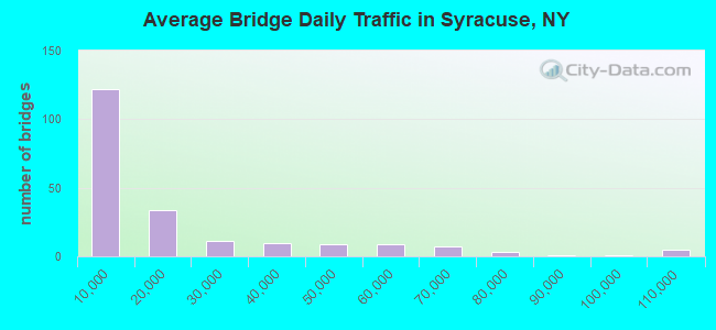
- 4,070,581Total average daily traffic
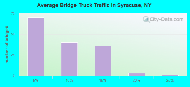
- 233,246Total average daily truck traffic
- National Bridge Inventory (NBI) Registered Bridges for Syracuse
- No street view available for this location
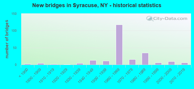
- New bridges - historical statistics
- 3Before 1900
- 41900-1909
- 21910-1919
- 11920-1929
- 41930-1939
- 131940-1949
- 111950-1959
- 1181960-1969
- 161970-1979
- 351980-1989
- 61990-1999
- 102000-2009
- 62010-2019
- 12020-2022
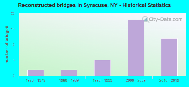
- Reconstructed bridges - Historical Statistics
- 21970-1979
- 21980-1989
- 51990-1999
- 182000-2009
- 122010-2019
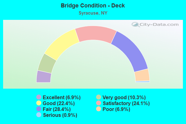
- Bridge Condition - Deck
- 6.9%Excellent
- 10.3%Very good
- 22.4%Good
- 24.1%Satisfactory
- 28.4%Fair
- 6.9%Poor
- 0.9%Serious
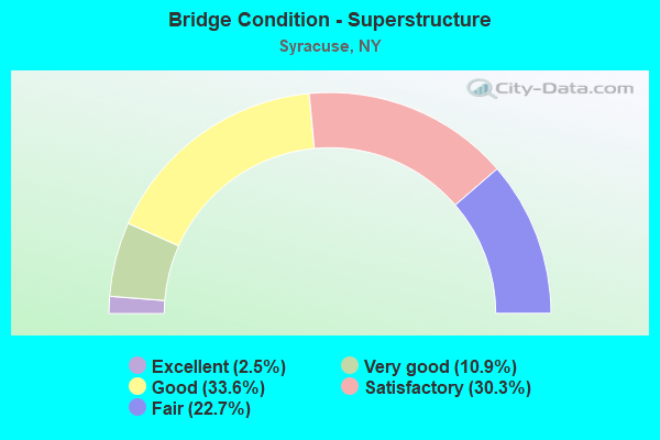
- Bridge Condition - Superstructure
- 2.5%Excellent
- 10.9%Very good
- 33.6%Good
- 30.3%Satisfactory
- 22.7%Fair
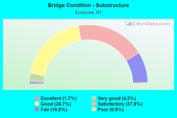
- Bridge Condition - Substructure
- 1.7%Excellent
- 4.2%Very good
- 38.7%Good
- 37.8%Satisfactory
- 16.8%Fair
- 0.8%Poor
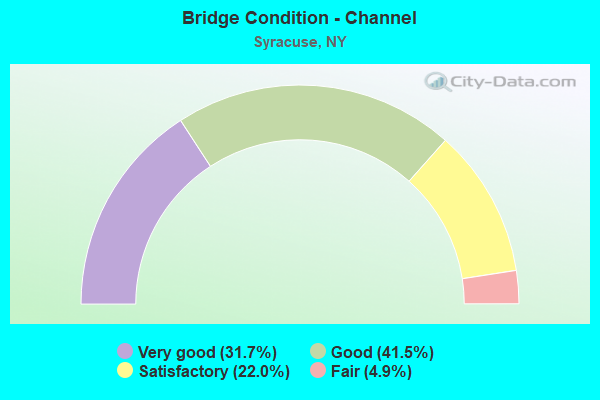
- Bridge Condition - Channel
- 31.7%Very good
- 41.5%Good
- 22.0%Satisfactory
- 4.9%Fair
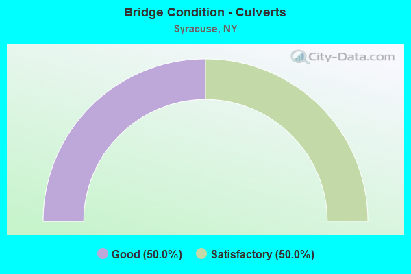
- Bridge Condition - Culverts
- 50.0%Good
- 50.0%Satisfactory
Find on map >> Show street view
Structure Number: 1053941, Location: JCT I690 WB & SH 298 (Lat: 43.056172, Lng: -76.173644), Route carried "under" structure: Business City street , Year Built: 1968, Structure Length: 0. m, Features Intersected: LIBERTY STREET, Facility Carried by Structure: RTE I690
Minimum Vertical Clearance: 5.51m (18.08ft), Kilometerpoint: 0.193, Lanes on structure: 3, Lanes under structure: 2, Material/Design: Steel, Design/Construction: Stringer/Multi-beam, Length of Maximum Span: 19.2m (63.0ft)
Find on map >> Show street view
Structure Number: 1053942, Location: JCT I690 EB & SH 298 (Lat: 43.055922, Lng: -76.173656), Route carried "under" structure: Business City street , Year Built: 1968, Structure Length: 0. m, Features Intersected: LIBERTY STREET, Facility Carried by Structure: RTE I690
Minimum Vertical Clearance: 5.51m (18.08ft), Kilometerpoint: 0.434, Lanes on structure: 3, Lanes under structure: 2, Material/Design: Steel, Design/Construction: Stringer/Multi-beam, Length of Maximum Span: 19.5m (64.0ft)
Find on map >> Show street view
Structure Number: 1053969, Location: .6 MI E JCT I-690 + 298 (Lat: 43.055619, Lng: -76.165969), Route carried "under" structure: City street , Year Built: 1968, Structure Length: 0. m, Features Intersected: VAN RENSSELAER ST, Facility Carried by Structure: RTE I690
Minimum Vertical Clearance: 4.37m (14.34ft), Kilometerpoint: 0.885, Lanes on structure: 8, Lanes under structure: 2, Material/Design: Steel, Design/Construction: Stringer/Multi-beam, Length of Maximum Span: 19.5m (64.0ft)
Find on map >> Show street view
Structure Number: 105402, Location: .8 MI E JCT I-690 + 298 (Lat: 43.054136, Lng: -76.153447), Route carried "under" structure: City street , Year Built: 1968, Structure Length: 0. m, Average Daily Traffic: 4,362 (year 2019), Truck Traffic: 5%, Features Intersected: N CLINTON STREET, Facility Carried by Structure: RTE I690
Minimum Vertical Clearance: 5.41m (17.75ft), Kilometerpoint: 0.000, Lanes on structure: 3, Lanes under structure: 2, Material/Design: Steel, Design/Construction: Stringer/Multi-beam, Length of Maximum Span: 19.8m (65.0ft)
Find on map >> Show street view
Structure Number: 106459, Location: CONNECTION I690WB & I81SB (Lat: 43.048553, Lng: -76.142675), Route carried "under" structure: Interstate , Year Built: 1968, Structure Length: 0. m, Average Daily Traffic: 6,188 (year 1976), Truck Traffic: 5%, Features Intersected: E. ERIE BOULEVARD, E Was, Facility Carried by Structure: RTE I81
Minimum Vertical Clearance: 4.83m (15.85ft), Kilometerpoint: 0.000, Lanes on structure: 2, Lanes under structure: 1, Material/Design: Steel, Design/Construction: Stringer/Multi-beam, Length of Maximum Span: 36.8m (120.7ft)
Find on map >> Show street view
Structure Number: 106909, Location: JCT I81 & I481 (Lat: 43.006025, Lng: -76.134692), Route carried "under" structure: Interstate 81, Year Built: 1980, Structure Length: 0. m, Average Daily Traffic: 31,275 (year 1999), Features Intersected: RTE I81, I81 SB TO I481
Minimum Vertical Clearance: 8.99m (29.49ft), Kilometerpoint: 2.011, Lanes on structure: 1, Lanes under structure: 4, Material/Design: Steel continuous, Design/Construction: Stringer/Multi-beam, Length of Maximum Span: 62.4m (204.7ft)
Find on map >> Show street view
Structure Number: 106909, Location: JCT I81 & I481 (Lat: 43.006025, Lng: -76.134692), Route carried "under" structure: Ramp Interstate , Year Built: 1980, Structure Length: 0. m, Average Daily Traffic: 5,500 (year 1971), Features Intersected: RTE I81, I81 SB TO I481, Facility Carried by Structure: I481 SB TO I81 SB
Minimum Vertical Clearance: 5.18m (16.99ft), Kilometerpoint: 0.000, Lanes on structure: 1, Lanes under structure: 2, Material/Design: Steel continuous, Design/Construction: Stringer/Multi-beam, Length of Maximum Span: 62.4m (204.7ft)
Find on map >> Show street view
Structure Number: 10691, Location: JCT I81 & I481 (Lat: 43.007156, Lng: -76.133903), Route carried "under" structure: Interstate 81, Year Built: 1980, Structure Length: 0. m, Average Daily Traffic: 46,220 (year 1999), Features Intersected: RTE I81
Minimum Vertical Clearance: 5.38m (17.65ft), Kilometerpoint: 0.000, Lanes on structure: 2, Lanes under structure: 2, Material/Design: Steel, Design/Construction: Stringer/Multi-beam, Length of Maximum Span: 33.2m (108.9ft)
Find on map >> Show street view
Structure Number: 106911, Location: .1 MI E JCT I81 & I481 (Lat: 43.006514, Lng: -76.131658), Route carried "under" structure: Ramp Interstate , Year Built: 1980, Structure Length: 0. m, Average Daily Traffic: 5,000 (year 1975), Features Intersected: I481RAMPFROMI81SB, I481R, Facility Carried by Structure: BRIGHTON AVE
Minimum Vertical Clearance: 5.07m (16.63ft), Kilometerpoint: 0.000, Lanes on structure: 7, Lanes under structure: 1, Material/Design: Steel, Design/Construction: Stringer/Multi-beam, Length of Maximum Span: 57.3m (188.0ft)
Find on map >> Show street view
Structure Number: 106912, Location: .1 MI E JCT I81 & I481 (Lat: 43.007681, Lng: -76.132106), Route carried "under" structure: Ramp Interstate , Year Built: 1980, Structure Length: 0. m, Average Daily Traffic: 5,000 (year 1975), Features Intersected: I481RAMPTO81NB, I481 RAM, Facility Carried by Structure: BRIGHTON AVE
Minimum Vertical Clearance: 5.49m (18.01ft), Kilometerpoint: 0.000, Lanes on structure: 4, Lanes under structure: 1, Material/Design: Steel, Design/Construction: Stringer/Multi-beam, Length of Maximum Span: 54.8m (179.8ft)
Find on map >> Show street view
Structure Number: 1071341, Location: 1.3 MI S JCT I81 & I90 (Lat: 43.074597, Lng: -76.171050), Route carried "under" structure: City street , Year Built: 1984, Structure Length: 0. m, Average Daily Traffic: 8,500 (year 1981), Features Intersected: FROM I81 TO SH370, Ley C, Facility Carried by Structure: RTE I81
Minimum Vertical Clearance: 5.11m (16.77ft), Kilometerpoint: 0.000, Lanes on structure: 3, Lanes under structure: 2, Material/Design: Steel continuous, Design/Construction: Stringer/Multi-beam, Length of Maximum Span: 85.3m (279.9ft)
Find on map >> Show street view
Structure Number: 1071342, Location: 1.3 MI S JCT I81 & I90 (Lat: 43.072883, Lng: -76.170078), Route carried "under" structure: City street , Year Built: 1984, Structure Length: 0. m, Average Daily Traffic: 8,500 (year 1981), Features Intersected: FROM I81 TO SH370, Ley C, Facility Carried by Structure: RTE I81
Minimum Vertical Clearance: 5.61m (18.41ft), Kilometerpoint: 10.652, Lanes on structure: 4, Lanes under structure: 2, Material/Design: Steel continuous, Design/Construction: Stringer/Multi-beam, Length of Maximum Span: 100.5m (329.7ft)
Find on map >> Show street view
Structure Number: 107134A, Location: 1.5 MI S JCT I81 & I90 (Lat: 43.071267, Lng: -76.168700), Route carried "under" structure: Ramp Interstate , Year Built: 1987, Structure Length: 0. m, Average Daily Traffic: 19,360 (year 1988), Features Intersected: RAMP B, Facility Carried by Structure: RAMP V
Minimum Vertical Clearance: 4.95m (16.24ft), Kilometerpoint: 0.000, Lanes on structure: 1, Lanes under structure: 3, Material/Design: Steel, Design/Construction: Stringer/Multi-beam, Length of Maximum Span: 42.0m (137.8ft)
Find on map >> Show street view
Structure Number: 107135, Location: 0.7MI NW 81I&HIAWATH BLVD (Lat: 43.076436, Lng: -76.175261), Route carried "under" structure: Ramp State highway , Year Built: 1987, Structure Length: 0. m, Average Daily Traffic: 1 (year 1988), Features Intersected: PARK ST, RAMP 81I NB TO, Facility Carried by Structure: FRM81I TO HIA BLVD
Minimum Vertical Clearance: 5.56m (18.24ft), Kilometerpoint: 0.000, Lanes on structure: 1, Lanes under structure: 1, Material/Design: Steel continuous, Design/Construction: Stringer/Multi-beam, Length of Maximum Span: 71.9m (235.9ft)
Find on map >> Show street view
Structure Number: 107136, Location: 0.6MI NW 81I&HIAWATH BLVD (Lat: 43.077117, Lng: -76.174792), Route carried "under" structure: Ramp Other road , Year Built: 1987, Structure Length: 0. m, Average Daily Traffic: 3,520 (year 1988), Features Intersected: FRM CR137 TO PK ST, FRM, Facility Carried by Structure: FROM I81 TO RT370
Minimum Vertical Clearance: 4.59m (15.06ft), Kilometerpoint: 0.000, Lanes on structure: 1, Lanes under structure: 2, Material/Design: Steel, Design/Construction: Stringer/Multi-beam, Length of Maximum Span: 58.8m (192.9ft)
Find on map >> Show street view
Structure Number: 107138, Location: .6 MI NW I81 & HIAWA BLVD (Lat: 43.076286, Lng: -76.173994), Route carried "under" structure: Ramp Other road , Year Built: 1987, Structure Length: 0. m, Average Daily Traffic: 3,520 (year 1988), Features Intersected: FRM CR137 TO PK ST, FRM, Facility Carried by Structure: FROM I81 TO CR137
Minimum Vertical Clearance: 5.41m (17.75ft), Kilometerpoint: 0.000, Lanes on structure: 1, Lanes under structure: 1, Material/Design: Steel, Design/Construction: Stringer/Multi-beam, Length of Maximum Span: 42.3m (138.8ft)
Find on map >> Show street view
Structure Number: 107139, Location: .7 MI NW JCT I81 & HI BVD (Lat: 43.076372, Lng: -76.174342), Route carried "under" structure: Ramp Other road 370, Year Built: 1987, Structure Length: 0. m, Average Daily Traffic: 1 (year 2021), Features Intersected: RTE 370, BIKEWAY, Facility Carried by Structure: FROM 81I TO CR137
Minimum Vertical Clearance: 4.44m (14.57ft), Kilometerpoint: 0.000, Lanes on structure: 2, Lanes under structure: 1, Material/Design: Steel continuous, Design/Construction: Stringer/Multi-beam, Length of Maximum Span: 39.3m (128.9ft)
Find on map >> Show street view
Structure Number: 109551, Location: JCT OF RTS I-690 WB +I-81 (Lat: 43.053547, Lng: -76.151450), Route carried "under" structure: Interstate 81, Year Built: 1968, Structure Length: 0. m, Average Daily Traffic: 102,011 (year 1999), Features Intersected: 81I 81I33032049 SB & NB,, Facility Carried by Structure: RTE I690
Minimum Vertical Clearance: 4.87m (15.98ft), Kilometerpoint: 8.850, Lanes on structure: 2, Lanes under structure: 2, Material/Design: Steel, Design/Construction: Stringer/Multi-beam, Length of Maximum Span: 30.7m (100.7ft)
Find on map >> Show street view
Structure Number: 220862, Location: E END CASTLE ST SYRACUSE (Lat: 43.036075, Lng: -76.141706), Route carried "under" structure: City street , Year Built: 1973, Structure Length: 0. m, Average Daily Traffic: 1,000 (year 2021), Features Intersected: RENWICK AVENUE, Facility Carried by Structure: FINEVIEW PLACE
Minimum Vertical Clearance: 4.62m (15.16ft), Kilometerpoint: 0.000, Lanes on structure: 2, Lanes under structure: 4, Material/Design: Steel, Design/Construction: Stringer/Multi-beam, Length of Maximum Span: 33.8m (110.9ft)
Find on map >> Show street view
Structure Number: 225778, Location: .2 MI SE CITY HALL (Lat: 43.046478, Lng: -76.152244), Route carried "under" structure: Business City street , Year Built: 1976, Structure Length: 0. m, Average Daily Traffic: 13,537 (year 1975), Features Intersected: SOUTH SALINA, Facility Carried by Structure: FOOT BRIDGE
Minimum Vertical Clearance: 4.54m (14.90ft), Kilometerpoint: 0.000, Lanes under structure: 6, Material/Design: Steel, Design/Construction: Truss - Thru, Length of Maximum Span: 19.2m (63.0ft)
Find on map >> Show street view
Structure Number: 225779, Location: .3 MI S CITY HALL (Lat: 43.049828, Lng: -76.152200), Route carried "under" structure: Business City street , Year Built: 1977, Structure Length: 0. m, Average Daily Traffic: 13,537 (year 1975), Features Intersected: SOUTH SALINA, Facility Carried by Structure: FOOT BRIDGE
Minimum Vertical Clearance: 4.92m (16.14ft), Kilometerpoint: 0.000, Lanes under structure: 6, Material/Design: Steel, Design/Construction: Truss - Thru, Length of Maximum Span: 19.2m (63.0ft)
Find on map >> Show street view
Structure Number: 22578, Location: .2 MI S CITY HALL (Lat: 43.047097, Lng: -76.151131), Route carried "under" structure: Business City street , Year Built: 1970, Structure Length: 0. m, Average Daily Traffic: 2,700 (year 1975), Features Intersected: E JEFFERSON ST, Facility Carried by Structure: FOOT BRIDGE
Minimum Vertical Clearance: 5.02m (16.47ft), Kilometerpoint: 0.000, Lanes under structure: 4, Material/Design: Steel, Design/Construction: Truss - Thru, Length of Maximum Span: 20.7m (67.9ft)
Find on map >> Show street view
Structure Number: 226643, Location: AT SYRACUSE - S SALINA ST (Lat: 43.044100, Lng: -76.152136), Route carried "under" structure: City street , Year Built: 1979, Structure Length: 0. m, Average Daily Traffic: 13,537 (year 1975), Features Intersected: SOUTH SALINA ST, Facility Carried by Structure: PEDESTRIAN WALK
Minimum Vertical Clearance: 7.62m (25.00ft), Kilometerpoint: 0.000, Lanes under structure: 6, Length of Maximum Span: 20.4m (66.9ft)
Find on map >> Show street view
Structure Number: 226644, Location: AT SYRACUSE - HARRISON ST (Lat: 43.044308, Lng: -76.151300), Route carried "under" structure: City street , Year Built: 1979, Structure Length: 0. m, Average Daily Traffic: 3,000 (year 2021), Features Intersected: HARRISON STREET, Facility Carried by Structure: PEDESTRIAN WALK
Minimum Vertical Clearance: 6.24m (20.47ft), Kilometerpoint: 0.000, Lanes under structure: 3, Material/Design: Concrete, Design/Construction: Stringer/Multi-beam, Length of Maximum Span: 15.8m (51.8ft)
Find on map >> Show street view
Structure Number: 7008471, Location: 0.9 MI S JCT RTS 11 + 5 (Lat: 43.039133, Lng: -76.147436), Route carried "under" structure: US 11, Year Built: 1941, Structure Length: 0. m, Average Daily Traffic: 8,040 (year 1999), Features Intersected: RTE 11, Facility Carried by Structure: NY SUSQUEHANNA& W
Minimum Vertical Clearance: 4.62m (15.16ft), Kilometerpoint: 6.339, Lanes under structure: 2, Material/Design: Steel, Design/Construction: Girder and Floorbeam System, Length of Maximum Span: 18.2m (59.7ft)
Find on map >> Show street view
Structure Number: 7008472, Location: 0.9 MI S JCT RTS 11 + 5 (Lat: 43.039231, Lng: -76.147450), Route carried "under" structure: US 11, Year Built: 1941, Structure Length: 0. m, Average Daily Traffic: 8,040 (year 1999), Features Intersected: RTE 11, Facility Carried by Structure: NY SUSQUEHANNA& W
Minimum Vertical Clearance: 4.62m (15.16ft), Kilometerpoint: 6.339, Lanes under structure: 2, Material/Design: Steel, Design/Construction: Girder and Floorbeam System, Length of Maximum Span: 18.2m (59.7ft)
Find on map >> Show street view
Structure Number: 702734, Location: .5 MI NW JCT RTS 57 & 11 (Lat: 43.075208, Lng: -76.171614), Route carried "under" structure: City street 370, Year Built: 1958, Structure Length: 0. m, Average Daily Traffic: 8,800 (year 1972), Features Intersected: RTE 370, Facility Carried by Structure: CSX TRANSPRTATION
Minimum Vertical Clearance: 4.03m (13.22ft), Kilometerpoint: 0.756, Lanes under structure: 2, Material/Design: Steel, Design/Construction: Girder and Floorbeam System, Length of Maximum Span: 42.3m (138.8ft)
Find on map >> Show street view
Structure Number: 704999, Location: .2 MI S JCT WEST ST ART+5 (Lat: 43.048019, Lng: -76.158328), Route carried "under" structure: State highway , Year Built: 1940, Structure Length: 0. m, Average Daily Traffic: 7,550 (year 1969), Features Intersected: WEST ST ARTERIAL, Facility Carried by Structure: NY SUSQUEHANNA& W
Minimum Vertical Clearance: 4.72m (15.49ft), Kilometerpoint: 1.014, Lanes under structure: 6, Material/Design: Steel, Design/Construction: Girder and Floorbeam System, Length of Maximum Span: 34.7m (113.8ft)
Find on map >> Show street view
Structure Number: 770034, Location: 1.4 MI W JCT RTS 5 + 11 (Lat: 43.048094, Lng: -76.174883), Route carried "under" structure: City street 5, Year Built: 1901, Structure Length: 0. m, Average Daily Traffic: 14,700 (year 1965), Features Intersected: RTE 5, Facility Carried by Structure: NY SUSQUEHANNA& W
Minimum Vertical Clearance: 4.16m (13.65ft), Kilometerpoint: 1.931, Lanes under structure: 4, Material/Design: Steel, Design/Construction: Truss - Thru, Length of Maximum Span: 39.0m (128.0ft)
Find on map >> Show street view
Structure Number: 770635, Location: 0.3 MI N OF EX 17 ON I81 (Lat: 43.019789, Lng: -76.139875), Route carried "under" structure: City street , Year Built: 1915, Structure Length: 0. m, Average Daily Traffic: 11,700 (year 1975), Features Intersected: E BRIGHTON AVE, Facility Carried by Structure: NY SUSQUEHANNA& W
Minimum Vertical Clearance: 5.72m (18.77ft), Kilometerpoint: 0.000, Lanes under structure: 2, Material/Design: Steel, Design/Construction: Stringer/Multi-beam, Length of Maximum Span: 13.4m (44.0ft)
Find on map >> Show street view
Structure Number: 770637, Location: 0.35 MI S OF EX 18 ON I81 (Lat: 43.035861, Lng: -76.141869), Route carried "under" structure: City street , Year Built: 1940, Structure Length: 0. m, Average Daily Traffic: 5,000 (year 2021), Features Intersected: RENWICK AVENUE, Facility Carried by Structure: NY SUSQUEHANNA& W
Minimum Vertical Clearance: 5.13m (16.83ft), Kilometerpoint: 0.000, Lanes under structure: 4, Material/Design: Steel, Design/Construction: Girder and Floorbeam System, Length of Maximum Span: 21.6m (70.9ft)
Find on map >> Show street view
Structure Number: 770639, Location: 0.15 MI SW EX 18 ON I81 (Lat: 43.038792, Lng: -76.143819), Route carried "under" structure: City street , Year Built: 1940, Structure Length: 0. m, Average Daily Traffic: 5,000 (year 2021), Features Intersected: S MCBRIDE STREET, Facility Carried by Structure: NY SUSQUEHANNA& W
Minimum Vertical Clearance: 4.29m (14.07ft), Kilometerpoint: 0.000, Lanes under structure: 2, Material/Design: Steel, Design/Construction: Girder and Floorbeam System, Length of Maximum Span: 24.0m (78.7ft)
Find on map >> Show street view
Structure Number: 77064, Location: 0.2 MI SW EX 18 ON I81 (Lat: 43.039250, Lng: -76.145606), Route carried "under" structure: City street , Year Built: 1940, Structure Length: 0. m, Average Daily Traffic: 10,800 (year 1975), Features Intersected: OAKWOOD AVENUE, Facility Carried by Structure: NY SUSQUEHANNA& W
Minimum Vertical Clearance: 4.29m (14.07ft), Kilometerpoint: 0.000, Lanes under structure: 2, Material/Design: Steel, Design/Construction: Girder and Floorbeam System, Length of Maximum Span: 19.2m (63.0ft)
Find on map >> Show street view
Structure Number: 770641, Location: 0.4 MI.W.EXIT 18 ON I81 (Lat: 43.039183, Lng: -76.148772), Route carried "under" structure: City street , Year Built: 1940, Structure Length: 0. m, Features Intersected: MONTGOMERY STREET, Facility Carried by Structure: NY SUSQUEHANNA& W
Minimum Vertical Clearance: 4.44m (14.57ft), Kilometerpoint: 0.000, Lanes under structure: 2, Material/Design: Steel, Design/Construction: Girder and Floorbeam System, Length of Maximum Span: 19.2m (63.0ft)
Find on map >> Show street view
Structure Number: 770643, Location: 0.5 MI W EX 18 ON I81 (Lat: 43.040258, Lng: -76.151903), Route carried "under" structure: City street , Year Built: 1940, Structure Length: 0. m, Average Daily Traffic: 6,500 (year 1975), Features Intersected: CLINTON STREET, Facility Carried by Structure: NY SUSQUEHANNA& W
Minimum Vertical Clearance: 4.62m (15.16ft), Kilometerpoint: 0.000, Lanes under structure: 2, Material/Design: Steel, Design/Construction: Girder and Floorbeam System, Length of Maximum Span: 26.8m (87.9ft)
Find on map >> Show street view
Structure Number: 770644, Location: 0.3 MI S OF ARMORYCITY OF (Lat: 43.042453, Lng: -76.153039), Route carried "under" structure: City street , Year Built: 1940, Structure Length: 0. m, Average Daily Traffic: 10,000 (year 2021), Features Intersected: W ADAMS STREET, Facility Carried by Structure: NY SUSQUEHANNA& W
Minimum Vertical Clearance: 5.10m (16.73ft), Kilometerpoint: 0.000, Lanes under structure: 4, Material/Design: Steel, Design/Construction: Girder and Floorbeam System, Length of Maximum Span: 21.6m (70.9ft)
Find on map >> Show street view
Structure Number: 7706491, Location: 0.1 MI S JCT SH5 & N GEDD (Lat: 43.047125, Lng: -76.170878), Route carried "under" structure: City street , Year Built: 1936, Structure Length: 0. m, Average Daily Traffic: 14,076 (year 1975), Features Intersected: S GEDDES STREET, Facility Carried by Structure: NY SUSQUEHANNA& W
Minimum Vertical Clearance: 4.19m (13.75ft), Kilometerpoint: 0.000, Lanes under structure: 4, Material/Design: Steel, Design/Construction: Stringer/Multi-beam, Length of Maximum Span: 16.1m (52.8ft)
Find on map >> Show street view
Structure Number: 7706492, Location: 0.1 MI S JCT SH5 & N GEDD (Lat: 43.046883, Lng: -76.170886), Route carried "under" structure: City street , Year Built: 1936, Structure Length: 0. m, Average Daily Traffic: 14,076 (year 1975), Features Intersected: S GEDDES STREET, Facility Carried by Structure: NY SUSQUEHANNA& W
Minimum Vertical Clearance: 4.21m (13.81ft), Kilometerpoint: 0.000, Lanes under structure: 4, Material/Design: Steel, Design/Construction: Girder and Floorbeam System, Length of Maximum Span: 15.2m (49.9ft)
Find on map >> Show street view
Structure Number: 7706493, Location: 0.1 MI S JCT SH5 & N GEDD (Lat: 43.046356, Lng: -76.170908), Route carried "under" structure: City street , Year Built: 1936, Structure Length: 0. m, Average Daily Traffic: 14,076 (year 1975), Features Intersected: S GEDDES STREET, Facility Carried by Structure: NY SUSQUEHANNA& W
Minimum Vertical Clearance: 4.14m (13.58ft), Kilometerpoint: 0.000, Lanes under structure: 4, Material/Design: Steel, Design/Construction: Girder and Floorbeam System, Length of Maximum Span: 16.7m (54.8ft)
Find on map >> Show street view
Structure Number: 77065, Location: JCT S H 5 & W GENESEE ST (Lat: 43.052197, Lng: -76.181758), Route carried "under" structure: City street , Year Built: 1940, Structure Length: 0. m, Average Daily Traffic: 21,800 (year 1975), Features Intersected: W GENESEE STREET, Facility Carried by Structure: NY SUSQUEHANNA& W
Minimum Vertical Clearance: 4.11m (13.48ft), Kilometerpoint: 0.000, Lanes under structure: 4, Material/Design: Steel, Design/Construction: Girder and Floorbeam System, Length of Maximum Span: 20.4m (66.9ft)
Find on map >> Show street view
Structure Number: 770651, Location: 0.5 S OF S TIP ONON. LAKE (Lat: 43.055544, Lng: -76.185114), Route carried "under" structure: City street , Year Built: 1949, Structure Length: 0. m, Average Daily Traffic: 15,942 (year 2017), Truck Traffic: 5%, Features Intersected: W HIAWATHA BLVD, Facility Carried by Structure: NY SUSQUEHANNA& W
Minimum Vertical Clearance: 4.34m (14.24ft), Kilometerpoint: 1.899, Lanes under structure: 4, Material/Design: Steel, Design/Construction: Stringer/Multi-beam, Length of Maximum Span: 16.1m (52.8ft)
Find on map >> Show street view
Structure Number: 770652, Location: 0.3 MI SE OF EX 25 ON I81 (Lat: 43.084092, Lng: -76.159542), Route carried "under" structure: County highway , Year Built: 1912, Structure Length: 0. m, Average Daily Traffic: 8,281 (year 2015), Truck Traffic: 7%, Features Intersected: 7TH N ST-CO RD 45, Facility Carried by Structure: CSX TRANSPRTATION
Minimum Vertical Clearance: 5.63m (18.47ft), Kilometerpoint: 0.000, Lanes under structure: 2, Material/Design: Steel, Design/Construction: Girder and Floorbeam System, Length of Maximum Span: 11.2m (36.7ft)
Find on map >> Show street view
Structure Number: 7714261, Location: .8MI S JCT BEAR ST<690 (Lat: 43.046558, Lng: -76.174436), Route carried "under" structure: City street , Year Built: 1940, Structure Length: 0. m, Average Daily Traffic: 5,000 (year 2021), Features Intersected: WEST FAYETTE ST, Facility Carried by Structure: NY SUS & W SIDING
Minimum Vertical Clearance: 4.19m (13.75ft), Kilometerpoint: 0.000, Lanes under structure: 2, Material/Design: Steel, Design/Construction: Girder and Floorbeam System, Length of Maximum Span: 23.4m (76.8ft)
Find on map >> Show street view
Structure Number: 7714262, Location: .8MI S JCT BEAR ST < 690 (Lat: 43.046597, Lng: -76.174631), Route carried "under" structure: City street , Year Built: 1940, Structure Length: 0. m, Average Daily Traffic: 5,000 (year 2021), Features Intersected: WEST FAYETTE ST, Facility Carried by Structure: NY SUS & W SIDING
Minimum Vertical Clearance: 4.34m (14.24ft), Kilometerpoint: 0.000, Lanes under structure: 2, Material/Design: Steel, Design/Construction: Girder and Floorbeam System, Length of Maximum Span: 23.1m (75.8ft)