Bridge Statistics for Syracuse, New York (NY)
Condition, Traffic, Stress, Structural Evaluation, Project Costs
- National Bridge Inventory (NBI) Statistics
- 230Number of bridges
- 3,885ft / 1,184mTotal length
- $697,683,000Total costs
- 4,070,581Total average daily traffic
- 233,246Total average daily truck traffic
- National Bridge Inventory (NBI) Registered Bridges for Syracuse
- No street view available for this location
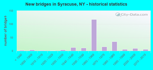
- New bridges - historical statistics
- 3Before 1900
- 41900-1909
- 21910-1919
- 11920-1929
- 41930-1939
- 131940-1949
- 111950-1959
- 1181960-1969
- 161970-1979
- 351980-1989
- 61990-1999
- 102000-2009
- 62010-2019
- 12020-2022
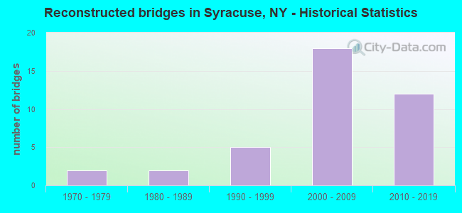
- Reconstructed bridges - Historical Statistics
- 21970-1979
- 21980-1989
- 51990-1999
- 182000-2009
- 122010-2019
- Bridge Condition - Deck
- 6.9%Excellent
- 10.3%Very good
- 22.4%Good
- 24.1%Satisfactory
- 28.4%Fair
- 6.9%Poor
- 0.9%Serious
- Bridge Condition - Superstructure
- 2.5%Excellent
- 10.9%Very good
- 33.6%Good
- 30.3%Satisfactory
- 22.7%Fair
- Bridge Condition - Substructure
- 1.7%Excellent
- 4.2%Very good
- 38.7%Good
- 37.8%Satisfactory
- 16.8%Fair
- 0.8%Poor
- Bridge Condition - Channel
- 31.7%Very good
- 41.5%Good
- 22.0%Satisfactory
- 4.9%Fair
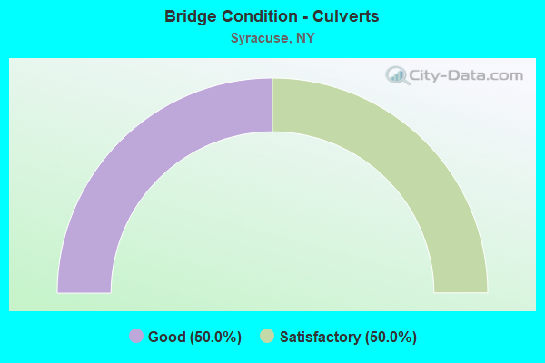
- Bridge Condition - Culverts
- 50.0%Good
- 50.0%Satisfactory
Find on map >> Show street view
Structure Number: 100207, Location: JCT OF RTS 5 +WEST ST ART (Lat: 43.050406, Lng: -76.159025), Route carried "on" structure: State highway 5, Year Built: 1964, Year Reconstructed: 2010, Status: Open, Structure Length: 4.27m (14.01ft), Average Daily Traffic: 7,402 (year 2017), Truck Traffic: 3%, Average Future Daily Traffic: 7,436 (year 2040), Design Load: HL 93, Features Intersected: N WEST ST ARTERIAL, S WE
Minimum Vertical Clearance: 30+ m (98+ ft), Kilometerpoint: 3.749, Lanes on structure: 4, Lanes under structure: 7, Owner: State Highway Agency, Approaching Roadway Width: 17.1m (56.1ft), Skew: 2 degrees, Material/Design: Steel continuous, Design/Construction: Stringer/Multi-beam, Number Of Spans In Main Unit: 2, Length of Maximum Span: 22.5m (73.8ft), Curb or Sidewalk Widths: Left: 1.6m (5.2ft), Right: 1.6m (5.2ft), Curb-To-Curb Width: 17.1m (56.1ft), Out-to-Out Width: 21.2m (69.6ft)
Condition: Deck: Excellent, Superstructure: Very good, Substructure: Good, Inventory Rating: 60.8 metric tons, Method Used To Determine Inventory Rating: Load Factor (LF), Structural Evaluation: Better than present minimum criteria, Deck Geometry: Somewhat better than minimum adequacy, Underclear: Meets minimum limits, Approach Roadway Alignment: Equal to present desirable criteria, Length Of Structure Improvement: 4.26m (13.98ft), Designated Inspection Frequency: Every 24 months, Inspection Date: September 2020, Bridge Improvement Cost: $2,604,000, Roadway Improvement Cost: $1,525,000, Total Project Cost: $4,128,000 ( Estimate for 2021), Deck Structure Type: Concrete Cast-file-Place, Wearing Surface/Protective System: Wearing Surface: Integral Concrete, Deck Protection: Epoxy Coated Reinforcing
Find on map >> Show street view
Structure Number: 1008489, Location: JCT I81 & NORTH SALINA S (Lat: 43.054289, Lng: -76.152117), Route carried "on" structure: Interstate 81, Year Built: 1958, Status: Open, Structure Length: 4.97m (16.31ft), Average Daily Traffic: 58,384 (year 2020), Truck Traffic: 6%, Average Future Daily Traffic: 84,218 (year 2040), Design Load: HS 20+Mod, Features Intersected: NORTH SALINA ST
Minimum Vertical Clearance: 30+ m (98+ ft), Kilometerpoint: 32.196, Lanes on structure: 5, Lanes under structure: 4, Base Highway Network: Yes, Owner: State Highway Agency, Approaching Roadway Width: 23.8m (78.1ft), Skew: 25 degrees, Material/Design: Steel continuous, Design/Construction: Stringer/Multi-beam, Number Of Spans In Main Unit: 2, Length of Maximum Span: 23.7m (77.8ft), Curb or Sidewalk Widths: Left: 0.5m (1.6ft), Right: 0.0m, Curb-To-Curb Width: 23.8m (78.1ft), Out-to-Out Width: 27.5m (90.2ft)
Condition: Deck: Serious, Superstructure: Satisfactory, Substructure: Good, Operating Rating: 46.7 metric tons, Method Used To Determine Operating Rating: Load and Resistance Factor Rating (LRFR) rating reported by rating factor(RF) method using HL-93 loadings, Inventory Rating: 36.0 metric tons, Method Used To Determine Inventory Rating: Load and Resistance Factor Rating (LRFR) rating reported by rating factor(RF) method using HL-93 loadings, Structural Evaluation: Equal to present minimum criteria, Deck Geometry: Equal to present minimum criteria, Underclear: Equal to present minimum criteria, Approach Roadway Alignment: Equal to present desirable criteria, Length Of Structure Improvement: 4.96m (16.27ft), Designated Inspection Frequency: Every 24 months, Inspection Date: June 2020, Bridge Improvement Cost: $5,939,000, Roadway Improvement Cost: $3,478,000, Total Project Cost: $9,417,000 ( Estimate for 2021), Deck Structure Type: Concrete Cast-file-Place, Wearing Surface/Protective System: Wearing Surface: Bituminous
Find on map >> Show street view
Structure Number: 10098, Location: 5.6 MI NE JCT RTE 12 + CL (Lat: 44.458706, Lng: -75.749075), Route carried "on" structure: State highway 12, Year Built: 1967, Status: Open, Structure Length: 3.96m (12.99ft), Average Daily Traffic: 1,180 (year 2016), Truck Traffic: 14%, Average Future Daily Traffic: 1,187 (year 2040), Design Load: H 20, Features Intersected: CHIPPEWA CREEK
Minimum Vertical Clearance: 30+ m (98+ ft), Kilometerpoint: 10.555, Lanes on structure: 2, Base Highway Network: Yes, Owner: State Highway Agency, Approaching Roadway Width: 9.1m (29.9ft), Material/Design: Steel, Design/Construction: Stringer/Multi-beam, Number Of Spans In Main Unit: 1, Length of Maximum Span: 38.1m (125.0ft), Curb or Sidewalk Widths: Left: 0.6m (2.0ft), Right: 0.6m (2.0ft), Curb-To-Curb Width: 8.5m (27.9ft), Out-to-Out Width: 10.1m (33.1ft)
Condition: Deck: Good, Superstructure: Good, Substructure: Good, Channel: Very good, Operating Rating: 69.9 metric tons, Method Used To Determine Operating Rating: Load Factor (LF), Inventory Rating: 36.3 metric tons, Method Used To Determine Inventory Rating: Load Factor (LF), Structural Evaluation: Better than present minimum criteria, Deck Geometry: Somewhat better than minimum adequacy, Waterway Adequacy: Equal to present minimum criteria, Approach Roadway Alignment: Equal to present desirable criteria, Length Of Structure Improvement: 3.96m (12.99ft), Designated Inspection Frequency: Every 24 months, Inspection Date: October 2021, Bridge Improvement Cost: $839,000, Roadway Improvement Cost: $492,000, Total Project Cost: $1,331,000 ( Estimate for 2021), Deck Structure Type: Concrete Cast-file-Place, Wearing Surface/Protective System: Wearing Surface: Bituminous
Find on map >> Show street view
Structure Number: 1031501, Location: JCT OF RTS I-81 SB + 173 (Lat: 43.002253, Lng: -76.135008), Route carried "on" structure: Interstate 81, Year Built: 1965, Year Reconstructed: 2007, Status: Open, Structure Length: 8.35m (27.40ft), Average Daily Traffic: 19,974 (year 2014), Truck Traffic: 16%, Design Load: HS 20, Features Intersected: RTE 173
Minimum Vertical Clearance: 30+ m (98+ ft), Kilometerpoint: 25.728, Lanes on structure: 3, Lanes under structure: 2, Base Highway Network: Yes, Owner: State Highway Agency, Approaching Roadway Width: 14.6m (47.9ft), Skew: 4 degrees, Material/Design: Steel, Design/Construction: Stringer/Multi-beam, Number Of Spans In Main Unit: 4, Length of Maximum Span: 27.1m (88.9ft), Curb-To-Curb Width: 14.5m (47.6ft), Out-to-Out Width: 15.4m (50.5ft)
Condition: Deck: Fair, Superstructure: Fair, Substructure: Fair, Operating Rating: 74.4 metric tons, Method Used To Determine Operating Rating: Load Factor (LF), Inventory Rating: 44.5 metric tons, Method Used To Determine Inventory Rating: Load Factor (LF), Structural Evaluation: Somewhat better than minimum adequacy, Deck Geometry: Meets minimum limits, Underclear: High priority of corrective action, Approach Roadway Alignment: Equal to present desirable criteria, Length Of Structure Improvement: 8.35m (27.40ft), Designated Inspection Frequency: Every 24 months, Inspection Date: May 2021, Bridge Improvement Cost: $2,624,000, Roadway Improvement Cost: $1,536,000, Total Project Cost: $4,160,000 ( Estimate for 2021), Deck Structure Type: Concrete Cast-file-Place, Wearing Surface/Protective System: Wearing Surface: Latex Concrete
Find on map >> Show street view
Structure Number: 1031502, Location: JCT OF RTS I-81 NB + 173 (Lat: 43.002744, Lng: -76.133906), Route carried "on" structure: Interstate 81, Year Built: 2006, Status: Open, Structure Length: 5.21m (17.09ft), Average Daily Traffic: 3,651 (year 2020), Truck Traffic: 22%, Average Future Daily Traffic: 5,266 (year 2040), Design Load: HS 25 or greater, Features Intersected: RTE 173
Minimum Vertical Clearance: 30+ m (98+ ft), Kilometerpoint: 0.000, Lanes on structure: 3, Lanes under structure: 2, Base Highway Network: Yes, Owner: State Highway Agency, Approaching Roadway Width: 20.4m (66.9ft), Skew: 3 degrees, Material/Design: Prestressed concrete, Design/Construction: Box Beam or Girders - Multiple, Number Of Spans In Main Unit: 2, Length of Maximum Span: 26.5m (86.9ft), Curb-To-Curb Width: 20.3m (66.6ft), Out-to-Out Width: 21.5m (70.5ft)
Condition: Deck: Good, Superstructure: Very good, Substructure: Good, Inventory Rating: 66.2 metric tons, Method Used To Determine Inventory Rating: Load Factor (LF), Structural Evaluation: Better than present minimum criteria, Deck Geometry: Superior to present desirable criteria, Underclear: Somewhat better than minimum adequacy, Approach Roadway Alignment: Equal to present desirable criteria, Length Of Structure Improvement: 5.21m (17.09ft), Designated Inspection Frequency: Every 24 months, Inspection Date: August 2021, Bridge Improvement Cost: $3,912,000, Roadway Improvement Cost: $2,291,000, Total Project Cost: $6,202,000 ( Estimate for 2021), Deck Structure Type: Concrete Cast-file-Place, Wearing Surface/Protective System: Wearing Surface: Integral Concrete, Deck Protection: Epoxy Coated Reinforcing
Find on map >> Show street view
Structure Number: 103151, Location: 0.5 MI N JCT RTS I-81+173 (Lat: 43.009142, Lng: -76.135858), Route carried "on" structure: City street , Year Built: 1965, Status: Open, Structure Length: 4.82m (15.81ft), Average Daily Traffic: 3,796 (year 2017), Truck Traffic: 3%, Average Future Daily Traffic: 5,314 (year 2037), Design Load: HS 20, Features Intersected: 81I 81I33032015 NB, RTE, Facility Carried by Structure: EAST GLEN AVENUE
Minimum Vertical Clearance: 30+ m (98+ ft), Kilometerpoint: 0.016, Lanes on structure: 2, Lanes under structure: 8, Owner: State Highway Agency, Approaching Roadway Width: 11.9m (39.0ft), Material/Design: Steel, Design/Construction: Stringer/Multi-beam, Number Of Spans In Main Unit: 2, Length of Maximum Span: 24.7m (81.0ft), Curb or Sidewalk Widths: Left: 0.5m (1.6ft), Right: 1.5m (4.9ft), Curb-To-Curb Width: 6.7m (22.0ft), Out-to-Out Width: 9.5m (31.2ft)
Condition: Deck: Fair, Superstructure: Satisfactory, Substructure: Fair, Operating Rating: 72.6 metric tons, Method Used To Determine Operating Rating: Load Factor (LF), Inventory Rating: 43.5 metric tons, Method Used To Determine Inventory Rating: Load Factor (LF), Structural Evaluation: Somewhat better than minimum adequacy, Deck Geometry: High priority of replacement, Underclear: High priority of corrective action, Approach Roadway Alignment: Equal to present desirable criteria, Length Of Structure Improvement: 4.81m (15.78ft), Designated Inspection Frequency: Every 24 months, Inspection Date: October 2021, Bridge Improvement Cost: $1,263,000, Roadway Improvement Cost: $739,000, Total Project Cost: $2,002,000 ( Estimate for 2021), Deck Structure Type: Concrete Cast-file-Place, Wearing Surface/Protective System: Wearing Surface: Integral Concrete
Find on map >> Show street view
Structure Number: 1031529, Location: EXIT 7 OF I81 (Lat: 43.016628, Lng: -76.139981), Route carried "on" structure: Interstate 81, Year Built: 1965, Year Reconstructed: 2013, Status: Open, Structure Length: 4.45m (14.60ft), Average Daily Traffic: 26,365 (year 2019), Truck Traffic: 14%, Average Future Daily Traffic: 38,031 (year 2040), Design Load: HS 20, Features Intersected: E CALTHROP AVENUE
Minimum Vertical Clearance: 30+ m (98+ ft), Kilometerpoint: 27.498, Lanes on structure: 6, Lanes under structure: 4, Base Highway Network: Yes, Owner: State Highway Agency, Approaching Roadway Width: 26.8m (87.9ft), Skew: 20 degrees, Material/Design: Steel, Design/Construction: Stringer/Multi-beam, Number Of Spans In Main Unit: 3, Length of Maximum Span: 19.8m (65.0ft), Curb-To-Curb Width: 28.6m (93.8ft), Out-to-Out Width: 30.4m (99.7ft)
Condition: Deck: Good, Superstructure: Fair, Substructure: Fair, Operating Rating: 86.2 metric tons, Method Used To Determine Operating Rating: Load Factor (LF), Inventory Rating: 51.7 metric tons, Method Used To Determine Inventory Rating: Load Factor (LF), Structural Evaluation: Somewhat better than minimum adequacy, Deck Geometry: Better than present minimum criteria, Underclear: Meets minimum limits, Approach Roadway Alignment: Equal to present desirable criteria, Length Of Structure Improvement: 4.45m (14.60ft), Designated Inspection Frequency: Every 24 months, Inspection Date: October 2021, Bridge Improvement Cost: $2,892,000, Roadway Improvement Cost: $1,693,000, Total Project Cost: $4,585,000 ( Estimate for 2021), Deck Structure Type: Concrete Precast Panels, Wearing Surface/Protective System: Wearing Surface: Integral Concrete
Find on map >> Show street view
Structure Number: 1031539, Location: 1.3 MI N JCT RTS I-81+173 (Lat: 43.020139, Lng: -76.140542), Route carried "on" structure: Interstate 81, Year Built: 1965, Status: Open, Structure Length: 6.19m (20.31ft), Average Daily Traffic: 32,686 (year 2020), Truck Traffic: 17%, Average Future Daily Traffic: 47,149 (year 2040), Design Load: HS 20, Features Intersected: EAST BRIGHTON AVE
Minimum Vertical Clearance: 30+ m (98+ ft), Kilometerpoint: 27.884, Lanes on structure: 7, Lanes under structure: 4, Base Highway Network: Yes, Owner: State Highway Agency, Approaching Roadway Width: 31.7m (104.0ft), Skew: 24 degrees, Material/Design: Steel, Design/Construction: Stringer/Multi-beam, Number Of Spans In Main Unit: 3, Length of Maximum Span: 27.4m (89.9ft), Curb-To-Curb Width: 31.1m (102.0ft), Out-to-Out Width: 33.5m (109.9ft)
Condition: Deck: Fair, Superstructure: Satisfactory, Substructure: Good, Operating Rating: 86.2 metric tons, Method Used To Determine Operating Rating: Load Factor (LF), Inventory Rating: 51.7 metric tons, Method Used To Determine Inventory Rating: Load Factor (LF), Structural Evaluation: Equal to present minimum criteria, Deck Geometry: Equal to present minimum criteria, Underclear: Somewhat better than minimum adequacy, Approach Roadway Alignment: Equal to present desirable criteria, Length Of Structure Improvement: 6.18m (20.28ft), Designated Inspection Frequency: Every 24 months, Inspection Date: October 2021, Bridge Improvement Cost: $4,341,000, Roadway Improvement Cost: $2,542,000, Total Project Cost: $6,884,000 ( Estimate for 2021), Deck Structure Type: Concrete Cast-file-Place, Wearing Surface/Protective System: Wearing Surface: Integral Concrete
Find on map >> Show street view
Structure Number: 1031549, Location: JCT OF I-81 + COLVIN ST (Lat: 43.026364, Lng: -76.140306), Route carried "on" structure: Interstate 81, Year Built: 1965, Status: Open, Structure Length: 1.98m (6.50ft), Average Daily Traffic: 32,686 (year 2020), Truck Traffic: 17%, Average Future Daily Traffic: 47,149 (year 2040), Design Load: HS 20, Features Intersected: EAST COLVIN ST
Minimum Vertical Clearance: 30+ m (98+ ft), Kilometerpoint: 28.608, Lanes on structure: 6, Lanes under structure: 2, Base Highway Network: Yes, Owner: State Highway Agency, Approaching Roadway Width: 33.2m (108.9ft), Skew: 20 degrees, Material/Design: Steel, Design/Construction: Stringer/Multi-beam, Number Of Spans In Main Unit: 1, Length of Maximum Span: 18.5m (60.7ft), Curb-To-Curb Width: 32.6m (107.0ft), Out-to-Out Width: 33.7m (110.6ft)
Condition: Deck: Poor, Superstructure: Satisfactory, Substructure: Satisfactory, Operating Rating: 86.2 metric tons, Method Used To Determine Operating Rating: Load Factor (LF), Inventory Rating: 51.7 metric tons, Method Used To Determine Inventory Rating: Load Factor (LF), Structural Evaluation: Equal to present minimum criteria, Deck Geometry: Superior to present desirable criteria, Underclear: Meets minimum limits, Approach Roadway Alignment: Equal to present desirable criteria, Length Of Structure Improvement: 1.98m (6.50ft), Designated Inspection Frequency: Every 24 months, Inspection Date: December 2021, Bridge Improvement Cost: $2,618,000, Roadway Improvement Cost: $1,533,000, Total Project Cost: $4,151,000 ( Estimate for 2021), Deck Structure Type: Concrete Cast-file-Place, Wearing Surface/Protective System: Wearing Surface: Integral Concrete
Find on map >> Show street view
Structure Number: 1031559, Location: JCT OF I-81 + MLK (Lat: 43.034464, Lng: -76.143014), Route carried "on" structure: Interstate 81, Year Built: 1965, Year Reconstructed: 2013, Status: Open, Structure Length: 4.82m (15.81ft), Average Daily Traffic: 51,509 (year 2020), Truck Traffic: 12%, Average Future Daily Traffic: 74,301 (year 2040), Design Load: HS 20, Features Intersected: Martin Luther King East
Minimum Vertical Clearance: 30+ m (98+ ft), Kilometerpoint: 29.525, Lanes on structure: 6, Lanes under structure: 2, Base Highway Network: Yes, Owner: State Highway Agency, Approaching Roadway Width: 28.0m (91.9ft), Skew: 22 degrees, Material/Design: Steel, Design/Construction: Stringer/Multi-beam, Number Of Spans In Main Unit: 3, Length of Maximum Span: 17.0m (55.8ft), Curb-To-Curb Width: 27.1m (88.9ft), Out-to-Out Width: 29.0m (95.1ft)
Condition: Deck: Good, Superstructure: Satisfactory, Substructure: Fair, Operating Rating: 83.5 metric tons, Method Used To Determine Operating Rating: Load Factor (LF), Inventory Rating: 57.2 metric tons, Method Used To Determine Inventory Rating: Load Factor (LF), Structural Evaluation: Somewhat better than minimum adequacy, Deck Geometry: Equal to present minimum criteria, Underclear: High priority of corrective action, Approach Roadway Alignment: Equal to present desirable criteria, Length Of Structure Improvement: 4.81m (15.78ft), Designated Inspection Frequency: Every 24 months, Inspection Date: October 2021, Bridge Improvement Cost: $3,084,000, Roadway Improvement Cost: $1,806,000, Total Project Cost: $4,890,000 ( Estimate for 2021), Deck Structure Type: Concrete Precast Panels, Wearing Surface/Protective System: Wearing Surface: Integral Concrete
Find on map >> Show street view
Structure Number: 1031569, Location: 2.4 MI N JCT RTS I-81+173 (Lat: 43.042708, Lng: -76.142433), Route carried "on" structure: Interstate 81, Year Built: 1966, Status: Open, Structure Length: 125.15m (410.60ft), Average Daily Traffic: 51,509 (year 2020), Truck Traffic: 14%, Average Future Daily Traffic: 74,301 (year 2040), Design Load: HS 20, Features Intersected: ALMOND STREET, BURT STRE
Minimum Vertical Clearance: 5.25m (17.22ft), Kilometerpoint: 29.847, Lanes on structure: 4, Lanes under structure: 20, Base Highway Network: Yes, Owner: State Highway Agency, Approaching Roadway Width: 30.8m (101.0ft), Skew: 20 degrees, Material/Design: Steel, Design/Construction: Stringer/Multi-beam, Number Of Spans In Main Unit: 36, Length of Maximum Span: 36.5m (119.8ft), Curb or Sidewalk Widths: Left: 0.5m (1.6ft), Right: 0.5m (1.6ft), Curb-To-Curb Width: 24.4m (80.1ft), Out-to-Out Width: 27.4m (89.9ft)
Condition: Deck: Fair, Superstructure: Fair, Substructure: Fair, Operating Rating: 58.1 metric tons, Method Used To Determine Operating Rating: Load Factor (LF), Inventory Rating: 34.5 metric tons, Method Used To Determine Inventory Rating: Load Factor (LF), Structural Evaluation: Somewhat better than minimum adequacy, Deck Geometry: High priority of corrective action, Underclear: High priority of corrective action, Approach Roadway Alignment: Equal to present desirable criteria, Length Of Structure Improvement: 125.15m (410.60ft), Designated Inspection Frequency: Every 24 months, Critical Feature Inspection Frequency: Every 12 months, Inspection Date: October 2021, Critical Feature Inspection Date: October 2021, Bridge Improvement Cost: $62,165,000, Roadway Improvement Cost: $36,404,000, Total Project Cost: $98,569,000 ( Estimate for 2021), Deck Structure Type: Concrete Cast-file-Place, Wearing Surface/Protective System: Wearing Surface: Monolithic Concrete
Find on map >> Show street view
Structure Number: 103156A, Location: EXIT 18 ON RAMP OF I81 (Lat: 43.040411, Lng: -76.142550), Route carried "on" structure: Ramp Interstate 81, Year Built: 1966, Status: Open, Structure Length: 19.93m (65.39ft), Average Daily Traffic: 4,602 (year 2016), Truck Traffic: 1%, Average Future Daily Traffic: 6,638 (year 2040), Design Load: HS 20, Features Intersected: JACKSON STREET
Minimum Vertical Clearance: 30+ m (98+ ft), Kilometerpoint: 0.080, Lanes on structure: 1, Lanes under structure: 2, Owner: State Highway Agency, Approaching Roadway Width: 5.8m (19.0ft), Material/Design: Steel, Design/Construction: Stringer/Multi-beam, Number Of Spans In Main Unit: 3, Number Of Approach Spans: 7, Length of Maximum Span: 35.9m (117.8ft), Curb or Sidewalk Widths: Left: 0.5m (1.6ft), Right: 0.5m (1.6ft), Curb-To-Curb Width: 5.8m (19.0ft), Out-to-Out Width: 7.6m (24.9ft)
Condition: Deck: Fair, Superstructure: Satisfactory, Substructure: Satisfactory, Operating Rating: 80.7 metric tons, Method Used To Determine Operating Rating: Field evaluation and documented engineering judgment, Inventory Rating: 29.4 metric tons, Method Used To Determine Inventory Rating: Field evaluation and documented engineering judgment, Structural Evaluation: Equal to present minimum criteria, Deck Geometry: Meets minimum limits, Underclear: Superior to present desirable criteria, Approach Roadway Alignment: Equal to present desirable criteria, Length Of Structure Improvement: 19.93m (65.39ft), Designated Inspection Frequency: Every 24 months, Critical Feature Inspection Frequency: Every 24 months, Inspection Date: December 2020, Critical Feature Inspection Date: December 2020, Bridge Improvement Cost: $2,725,000, Roadway Improvement Cost: $1,596,000, Total Project Cost: $4,321,000 ( Estimate for 2021), Deck Structure Type: Concrete Cast-file-Place, Wearing Surface/Protective System: Wearing Surface: Monolithic Concrete
Find on map >> Show street view
Structure Number: 103156B, Location: EXIT 18 OFF RAMP OF I81 (Lat: 43.040411, Lng: -76.142181), Route carried "on" structure: Ramp Interstate 81, Year Built: 1966, Status: Open, Structure Length: 19.99m (65.58ft), Average Daily Traffic: 5,194 (year 2017), Truck Traffic: 4%, Average Future Daily Traffic: 7,492 (year 2040), Design Load: HS 20, Features Intersected: JACKSON STREET
Minimum Vertical Clearance: 30+ m (98+ ft), Kilometerpoint: 0.193, Lanes on structure: 1, Lanes under structure: 1, Owner: State Highway Agency, Approaching Roadway Width: 5.2m (17.1ft), Material/Design: Steel, Design/Construction: Stringer/Multi-beam, Number Of Spans In Main Unit: 3, Number Of Approach Spans: 7, Length of Maximum Span: 36.0m (118.1ft), Curb or Sidewalk Widths: Left: 0.5m (1.6ft), Right: 0.5m (1.6ft), Curb-To-Curb Width: 5.2m (17.1ft), Out-to-Out Width: 6.9m (22.6ft)
Condition: Deck: Fair, Superstructure: Satisfactory, Substructure: Satisfactory, Operating Rating: 81.5 metric tons, Method Used To Determine Operating Rating: Field evaluation and documented engineering judgment, Inventory Rating: 32.7 metric tons, Method Used To Determine Inventory Rating: Field evaluation and documented engineering judgment, Structural Evaluation: Equal to present minimum criteria, Deck Geometry: High priority of corrective action, Underclear: High priority of corrective action, Approach Roadway Alignment: Equal to present desirable criteria, Length Of Structure Improvement: 19.99m (65.58ft), Designated Inspection Frequency: Every 24 months, Critical Feature Inspection Frequency: Every 24 months, Inspection Date: December 2020, Critical Feature Inspection Date: December 2020, Bridge Improvement Cost: $2,544,000, Roadway Improvement Cost: $1,490,000, Total Project Cost: $4,033,000 ( Estimate for 2021), Deck Structure Type: Concrete Cast-file-Place, Wearing Surface/Protective System: Wearing Surface: Integral Concrete
Find on map >> Show street view
Structure Number: 103156C, Location: I81 NB ON RAMP; VIADUCT (Lat: 43.046492, Lng: -76.142342), Route carried "on" structure: Ramp Interstate , Year Built: 1966, Status: Open, Structure Length: 13.84m (45.41ft), Average Daily Traffic: 13,637 (year 2016), Truck Traffic: 2%, Average Future Daily Traffic: 19,671 (year 2040), Design Load: HS 20, Features Intersected: RELIEF, Facility Carried by Structure: I-81 NB ON RAMP
Minimum Vertical Clearance: 30+ m (98+ ft), Kilometerpoint: 0.145, Lanes on structure: 2, Owner: State Highway Agency, Approaching Roadway Width: 7.9m (25.9ft), Skew: 2 degrees, Material/Design: Steel, Design/Construction: Stringer/Multi-beam, Number Of Spans In Main Unit: 2, Number Of Approach Spans: 6, Length of Maximum Span: 33.5m (109.9ft), Curb or Sidewalk Widths: Left: 0.5m (1.6ft), Right: 0.5m (1.6ft), Curb-To-Curb Width: 8.0m (26.2ft), Out-to-Out Width: 9.7m (31.8ft)
Condition: Deck: Satisfactory, Superstructure: Satisfactory, Substructure: Satisfactory, Operating Rating: 79.6 metric tons, Method Used To Determine Operating Rating: Field evaluation and documented engineering judgment, Inventory Rating: 29.4 metric tons, Method Used To Determine Inventory Rating: Field evaluation and documented engineering judgment, Structural Evaluation: Equal to present minimum criteria, Deck Geometry: High priority of corrective action, Approach Roadway Alignment: Equal to present desirable criteria, Length Of Structure Improvement: 13.83m (45.37ft), Designated Inspection Frequency: Every 24 months, Critical Feature Inspection Frequency: Every 24 months, Inspection Date: December 2020, Critical Feature Inspection Date: December 2020, Bridge Improvement Cost: $2,458,000, Roadway Improvement Cost: $1,439,000, Total Project Cost: $3,897,000 ( Estimate for 2021), Deck Structure Type: Concrete Cast-file-Place, Wearing Surface/Protective System: Wearing Surface: Monolithic Concrete
Find on map >> Show street view
Structure Number: 103156D, Location: I81 SB OFF RAMP; VIADUCT (Lat: 43.046883, Lng: -76.142764), Route carried "on" structure: Interstate 81, Year Built: 1966, Status: Open, Structure Length: 16.03m (52.59ft), Average Daily Traffic: 8,369 (year 2017), Truck Traffic: 2%, Average Future Daily Traffic: 12,072 (year 2040), Design Load: HS 20, Features Intersected: RTE 92
Minimum Vertical Clearance: 6.12m (20.08ft), Kilometerpoint: 0.032, Lanes on structure: 1, Lanes under structure: 2, Owner: State Highway Agency, Approaching Roadway Width: 6.7m (22.0ft), Skew: 2 degrees, Material/Design: Steel, Design/Construction: Stringer/Multi-beam, Number Of Spans In Main Unit: 3, Number Of Approach Spans: 5, Length of Maximum Span: 33.5m (109.9ft), Curb or Sidewalk Widths: Left: 0.5m (1.6ft), Right: 0.5m (1.6ft), Curb-To-Curb Width: 6.8m (22.3ft), Out-to-Out Width: 9.1m (29.9ft)
Condition: Deck: Satisfactory, Superstructure: Satisfactory, Substructure: Satisfactory, Operating Rating: 80.4 metric tons, Method Used To Determine Operating Rating: Field evaluation and documented engineering judgment, Inventory Rating: 32.7 metric tons, Method Used To Determine Inventory Rating: Field evaluation and documented engineering judgment, Structural Evaluation: Equal to present minimum criteria, Deck Geometry: High priority of replacement, Underclear: High priority of corrective action, Approach Roadway Alignment: Equal to present desirable criteria, Length Of Structure Improvement: 16.03m (52.59ft), Designated Inspection Frequency: Every 24 months, Critical Feature Inspection Frequency: Every 24 months, Inspection Date: December 2020, Critical Feature Inspection Date: December 2020, Bridge Improvement Cost: $2,664,000, Roadway Improvement Cost: $1,560,000, Total Project Cost: $4,224,000 ( Estimate for 2021), Deck Structure Type: Concrete Cast-file-Place, Wearing Surface/Protective System: Wearing Surface: Monolithic Concrete
Find on map >> Show street view
Structure Number: 103157, Location: 0.9 MI S JCT RTS I-81+298 (Lat: 43.056531, Lng: -76.153464), Route carried "on" structure: City street , Year Built: 2010, Status: Open, Structure Length: 5.76m (18.90ft), Average Daily Traffic: 12,057 (year 2017), Truck Traffic: 5%, Average Future Daily Traffic: 14,646 (year 2040), Design Load: HS 25 or greater, Features Intersected: 81I 81I33032053, RTE I81, Facility Carried by Structure: BUTTERNUT STREET
Minimum Vertical Clearance: 30+ m (98+ ft), Kilometerpoint: 0.193, Lanes on structure: 4, Lanes under structure: 6, Owner: State Highway Agency, Approaching Roadway Width: 14.9m (48.9ft), Skew: 5 degrees, Material/Design: Steel continuous, Design/Construction: Stringer/Multi-beam, Number Of Spans In Main Unit: 2, Length of Maximum Span: 27.6m (90.6ft), Curb or Sidewalk Widths: Left: 1.7m (5.6ft), Right: 1.7m (5.6ft), Curb-To-Curb Width: 14.9m (48.9ft), Out-to-Out Width: 20.1m (65.9ft)
Condition: Deck: Very good, Superstructure: Very good, Substructure: Good, Operating Rating: 75.3 metric tons, Method Used To Determine Operating Rating: Load Factor (LF), Inventory Rating: 44.5 metric tons, Method Used To Determine Inventory Rating: Load Factor (LF), Structural Evaluation: Better than present minimum criteria, Deck Geometry: High priority of replacement, Underclear: Meets minimum limits, Approach Roadway Alignment: Equal to present desirable criteria, Length Of Structure Improvement: 5.76m (18.90ft), Designated Inspection Frequency: Every 24 months, Inspection Date: October 2020, Bridge Improvement Cost: $3,639,000, Roadway Improvement Cost: $2,131,000, Total Project Cost: $5,771,000 ( Estimate for 2021), Deck Structure Type: Concrete Cast-file-Place, Wearing Surface/Protective System: Wearing Surface: Integral Concrete, Deck Protection: Epoxy Coated Reinforcing
Find on map >> Show street view
Structure Number: 103158, Location: 0.5 MI S JCT RTS I-81+298 (Lat: 43.061067, Lng: -76.156314), Route carried "on" structure: City street , Year Built: 2009, Status: Open, Structure Length: 4.02m (13.19ft), Average Daily Traffic: 6,037 (year 2018), Truck Traffic: 3%, Average Future Daily Traffic: 7,469 (year 2040), Design Load: HS 25 or greater, Features Intersected: 81I 81I33032055 SB, RTE, Facility Carried by Structure: SPENCER STREET
Minimum Vertical Clearance: 30+ m (98+ ft), Kilometerpoint: 1.271, Lanes on structure: 4, Lanes under structure: 9, Owner: State Highway Agency, Approaching Roadway Width: 15.8m (51.8ft), Skew: 2 degrees, Material/Design: Steel continuous, Design/Construction: Stringer/Multi-beam, Number Of Spans In Main Unit: 2, Length of Maximum Span: 19.5m (64.0ft), Curb or Sidewalk Widths: Left: 1.7m (5.6ft), Right: 1.7m (5.6ft), Curb-To-Curb Width: 15.8m (51.8ft), Out-to-Out Width: 20.1m (65.9ft)
Condition: Deck: Good, Superstructure: Good, Substructure: Good, Operating Rating: 93.0 metric tons, Method Used To Determine Operating Rating: Load Factor (LF), Inventory Rating: 56.0 metric tons, Method Used To Determine Inventory Rating: Load Factor (LF), Structural Evaluation: Better than present minimum criteria, Deck Geometry: Meets minimum limits, Underclear: Meets minimum limits, Approach Roadway Alignment: Equal to present desirable criteria, Length Of Structure Improvement: 4.02m (13.19ft), Designated Inspection Frequency: Every 24 months, Inspection Date: August 2021, Bridge Improvement Cost: $2,133,000, Roadway Improvement Cost: $1,249,000, Total Project Cost: $3,381,000 ( Estimate for 2021), Deck Structure Type: Concrete Cast-file-Place, Wearing Surface/Protective System: Wearing Surface: Integral Concrete, Deck Protection: Epoxy Coated Reinforcing
Find on map >> Show street view
Structure Number: 103159, Location: JCT OF I-81 + COURT ST (Lat: 43.064758, Lng: -76.160439), Route carried "on" structure: City street 298, Year Built: 2009, Status: Open, Structure Length: 6.00m (19.69ft), Truck Traffic: 5%, Design Load: HS 25 or greater, Features Intersected: 81I 81I33032058 SB, RTE
Minimum Vertical Clearance: 30+ m (98+ ft), Kilometerpoint: 1.657, Lanes on structure: 4, Lanes under structure: 6, Base Highway Network: Yes, Owner: State Highway Agency, Approaching Roadway Width: 15.8m (51.8ft), Skew: 4 degrees, Material/Design: Steel continuous, Design/Construction: Stringer/Multi-beam, Number Of Spans In Main Unit: 2, Length of Maximum Span: 29.8m (97.8ft), Curb or Sidewalk Widths: Left: 1.7m (5.6ft), Right: 1.7m (5.6ft), Curb-To-Curb Width: 15.8m (51.8ft), Out-to-Out Width: 27.0m (88.6ft)
Condition: Deck: Satisfactory, Superstructure: Good, Substructure: Good, Operating Rating: 91.0 metric tons, Method Used To Determine Operating Rating: Load Factor (LF), Inventory Rating: 54.0 metric tons, Method Used To Determine Inventory Rating: Load Factor (LF), Structural Evaluation: Better than present minimum criteria, Deck Geometry: Meets minimum limits, Underclear: High priority of corrective action, Approach Roadway Alignment: Equal to present desirable criteria, Length Of Structure Improvement: 6.00m (19.69ft), Designated Inspection Frequency: Every 24 months, Inspection Date: August 2021, Bridge Improvement Cost: $4,415,000, Roadway Improvement Cost: $2,585,000, Total Project Cost: $7,001,000 ( Estimate for 2021), Deck Structure Type: Concrete Cast-file-Place, Wearing Surface/Protective System: Wearing Surface: Integral Concrete, Deck Protection: Epoxy Coated Reinforcing
Find on map >> Show street view
Structure Number: 10316, Location: JCT OF RTS I-81 + 298 (Lat: 43.066261, Lng: -76.163833), Route carried "on" structure: City street 298, Year Built: 1959, Status: Open, Structure Length: 3.44m (11.29ft), Truck Traffic: 5%, Design Load: HS 20, Features Intersected: 81I 81I33032060 SB, RTE
Minimum Vertical Clearance: 30+ m (98+ ft), Kilometerpoint: 0.274, Lanes on structure: 4, Lanes under structure: 7, Owner: State Highway Agency, Approaching Roadway Width: 15.8m (51.8ft), Material/Design: Steel continuous, Design/Construction: Stringer/Multi-beam, Number Of Spans In Main Unit: 2, Length of Maximum Span: 16.4m (53.8ft), Curb or Sidewalk Widths: Left: 1.8m (5.9ft), Right: 1.8m (5.9ft), Curb-To-Curb Width: 15.8m (51.8ft), Out-to-Out Width: 20.0m (65.6ft)
Condition: Deck: Fair, Superstructure: Satisfactory, Substructure: Fair, Operating Rating: 73.5 metric tons, Method Used To Determine Operating Rating: Load Factor (LF), Inventory Rating: 43.5 metric tons, Method Used To Determine Inventory Rating: Load Factor (LF), Structural Evaluation: Somewhat better than minimum adequacy, Deck Geometry: Meets minimum limits, Underclear: High priority of corrective action, Approach Roadway Alignment: Equal to present desirable criteria, Length Of Structure Improvement: 3.44m (11.29ft), Designated Inspection Frequency: Every 24 months, Inspection Date: October 2021, Bridge Improvement Cost: $1,954,000, Roadway Improvement Cost: $1,144,000, Total Project Cost: $3,098,000 ( Estimate for 2021), Deck Structure Type: Concrete Cast-file-Place, Wearing Surface/Protective System: Wearing Surface: Integral Concrete
Find on map >> Show street view
Structure Number: 103161, Location: JCT I81 & HIAWATHA BLVD (Lat: 43.069547, Lng: -76.168264), Route carried "on" structure: City street , Year Built: 1987, Status: Open, Structure Length: 13.05m (42.81ft), Average Daily Traffic: 19,781 (year 2016), Truck Traffic: 5%, Average Future Daily Traffic: 19,873 (year 2040), Design Load: HS 20, Features Intersected: 81I 81I33032163 NB, Mall, Facility Carried by Structure: HIAWATHA BLVD
Minimum Vertical Clearance: 30+ m (98+ ft), Kilometerpoint: 0.080, Lanes on structure: 6, Lanes under structure: 13, Owner: State Highway Agency, Approaching Roadway Width: 24.4m (80.1ft), Skew: 21 degrees, Material/Design: Steel continuous, Design/Construction: Stringer/Multi-beam, Number Of Spans In Main Unit: 3, Length of Maximum Span: 50.2m (164.7ft), Curb or Sidewalk Widths: Left: 1.5m (4.9ft), Right: 1.5m (4.9ft), Curb-To-Curb Width: 24.4m (80.1ft), Out-to-Out Width: 29.2m (95.8ft)
Condition: Deck: Fair, Superstructure: Good, Substructure: Satisfactory, Operating Rating: 72.6 metric tons, Method Used To Determine Operating Rating: Load Factor (LF), Inventory Rating: 43.5 metric tons, Method Used To Determine Inventory Rating: Load Factor (LF), Structural Evaluation: Equal to present minimum criteria, Deck Geometry: Somewhat better than minimum adequacy, Underclear: High priority of corrective action, Approach Roadway Alignment: Equal to present desirable criteria, Length Of Structure Improvement: 13.04m (42.78ft), Designated Inspection Frequency: Every 24 months, Inspection Date: August 2020, Bridge Improvement Cost: $8,447,000, Roadway Improvement Cost: $4,946,000, Total Project Cost: $13,393,000 ( Estimate for 2021), Deck Structure Type: Concrete Cast-file-Place, Wearing Surface/Protective System: Wearing Surface: Integral Concrete, Deck Protection: Epoxy Coated Reinforcing
Find on map >> Show street view
Structure Number: 103162, Location: 0.1 MI W JCT 81I&HIA BLVD (Lat: 43.071100, Lng: -76.169914), Route carried "on" structure: Ramp Interstate , Year Built: 1987, Status: Open, Structure Length: 21.88m (71.78ft), Average Daily Traffic: 5,044 (year 2016), Truck Traffic: 5%, Average Future Daily Traffic: 5,067 (year 2040), Design Load: HS 20, Features Intersected: 81I 81I33032066 NB, RTE, Facility Carried by Structure: FRM 81I-HIA BLVD
Minimum Vertical Clearance: 30+ m (98+ ft), Kilometerpoint: 0.225, Lanes on structure: 1, Lanes under structure: 14, Owner: State Highway Agency, Approaching Roadway Width: 7.6m (24.9ft), Material/Design: Steel continuous, Design/Construction: Stringer/Multi-beam, Number Of Spans In Main Unit: 5, Length of Maximum Span: 44.5m (146.0ft), Curb-To-Curb Width: 7.4m (24.3ft), Out-to-Out Width: 8.4m (27.6ft)
Condition: Deck: Satisfactory, Superstructure: Satisfactory, Substructure: Fair, Inventory Rating: 32.7 metric tons, Method Used To Determine Inventory Rating: Field evaluation and documented engineering judgment, Structural Evaluation: Somewhat better than minimum adequacy, Deck Geometry: Better than present minimum criteria, Underclear: High priority of corrective action, Approach Roadway Alignment: Equal to present desirable criteria, Length Of Structure Improvement: 21.88m (71.78ft), Designated Inspection Frequency: Every 24 months, Inspection Date: May 2021, Bridge Improvement Cost: $3,584,000, Roadway Improvement Cost: $2,099,000, Total Project Cost: $5,682,000 ( Estimate for 2021), Deck Structure Type: Concrete Cast-file-Place, Wearing Surface/Protective System: Wearing Surface: Integral Concrete, Deck Protection: Epoxy Coated Reinforcing
Find on map >> Show street view
Structure Number: 1031639, Location: 0.1 MI S JCT RTS I-81 +57 (Lat: 43.074508, Lng: -76.172164), Route carried "on" structure: Ramp Other road , Year Built: 1959, Year Reconstructed: 1987, Status: Open, Structure Length: 20.45m (67.09ft), Average Daily Traffic: 4,690 (year 2020), Truck Traffic: 6%, Average Future Daily Traffic: 6,765 (year 2040), Design Load: HS 20+Mod, Features Intersected: HARBORSIDE DRIVE, LEY CR, Facility Carried by Structure: 81I TO ROUTE 370
Minimum Vertical Clearance: 6.99m (22.93ft), Kilometerpoint: 0.756, Lanes on structure: 5, Lanes under structure: 3, Owner: State Highway Agency, Approaching Roadway Width: 29.3m (96.1ft), Skew: 20 degrees, Material/Design: Steel, Design/Construction: Stringer/Multi-beam, Number Of Spans In Main Unit: 9, Length of Maximum Span: 33.8m (110.9ft), Curb-To-Curb Width: 28.0m (91.9ft), Out-to-Out Width: 30.3m (99.4ft)
Condition: Deck: Fair, Superstructure: Fair, Substructure: Poor, Channel: Very good, Operating Rating: 78.0 metric tons, Method Used To Determine Operating Rating: Load Factor (LF), Inventory Rating: 47.2 metric tons, Method Used To Determine Inventory Rating: Load Factor (LF), Structural Evaluation: Meets minimum limits, Deck Geometry: Superior to present desirable criteria, Underclear: High priority of corrective action, Waterway Adequacy: Superior to present desirable criteria, Approach Roadway Alignment: Equal to present desirable criteria, Length Of Structure Improvement: 20.45m (67.09ft), Designated Inspection Frequency: Every 24 months, Inspection Date: November 2021, Bridge Improvement Cost: $11,729,000, Roadway Improvement Cost: $6,869,000, Total Project Cost: $18,598,000 ( Estimate for 2021), Deck Structure Type: Concrete Cast-file-Place, Wearing Surface/Protective System: Wearing Surface: Integral Concrete, Deck Protection: Epoxy Coated Reinforcing
Find on map >> Show street view
Structure Number: 1049641, Location: .7 MI W JCT I690 & NY298 (Lat: 43.061078, Lng: -76.188497), Route carried "on" structure: Interstate 690, Year Built: 2007, Status: Open, Structure Length: 10.97m (35.99ft), Average Daily Traffic: 38,721 (year 2005), Truck Traffic: 13%, Design Load: HL 93, Features Intersected: NY S&W, CSX TRANS/AMTRAK
Minimum Vertical Clearance: 30+ m (98+ ft), Kilometerpoint: 10.748, Lanes on structure: 4, Base Highway Network: Yes, Owner: State Highway Agency, Approaching Roadway Width: 18.6m (61.0ft), Skew: 4 degrees, Material/Design: Steel, Design/Construction: Stringer/Multi-beam, Number Of Spans In Main Unit: 4, Length of Maximum Span: 32.0m (105.0ft), Curb-To-Curb Width: 18.6m (61.0ft), Out-to-Out Width: 19.5m (64.0ft)
Condition: Deck: Good, Superstructure: Very good, Substructure: Very good, Operating Rating: 71.3 metric tons, Method Used To Determine Operating Rating: Load and Resistance Factor Rating (LRFR) rating reported by rating factor(RF) method using HL-93 loadings, Inventory Rating: 55.1 metric tons, Method Used To Determine Inventory Rating: Load and Resistance Factor Rating (LRFR) rating reported by rating factor(RF) method using HL-93 loadings, Structural Evaluation: Equal to present desirable criteria, Deck Geometry: Meets minimum limits, Underclear: High priority of corrective action, Approach Roadway Alignment: Equal to present desirable criteria, Length Of Structure Improvement: 10.97m (35.99ft), Designated Inspection Frequency: Every 24 months, Inspection Date: June 2021, Bridge Improvement Cost: $4,327,000, Roadway Improvement Cost: $2,534,000, Total Project Cost: $6,862,000 ( Estimate for 2021), Deck Structure Type: Concrete Cast-file-Place, Wearing Surface/Protective System: Wearing Surface: Monolithic Concrete, Deck Protection: Epoxy Coated Reinforcing
Find on map >> Show street view
Structure Number: 1049642, Location: .7MI W JCT I-690 & NY 298 (Lat: 43.061044, Lng: -76.188772), Route carried "on" structure: Interstate 690, Year Built: 2008, Status: Open, Structure Length: 10.97m (35.99ft), Average Daily Traffic: 25,816 (year 2018), Truck Traffic: 6%, Average Future Daily Traffic: 37,239 (year 2040), Design Load: HL 93, Features Intersected: NY S&W, CSX TRANS/AMTRAK
Minimum Vertical Clearance: 30+ m (98+ ft), Kilometerpoint: 10.748, Lanes on structure: 3, Base Highway Network: Yes, Owner: State Highway Agency, Approaching Roadway Width: 16.2m (53.1ft), Skew: 4 degrees, Material/Design: Steel continuous, Design/Construction: Stringer/Multi-beam, Number Of Spans In Main Unit: 4, Length of Maximum Span: 32.0m (105.0ft), Curb-To-Curb Width: 16.2m (53.1ft), Out-to-Out Width: 17.0m (55.8ft)
Condition: Deck: Good, Superstructure: Very good, Substructure: Good, Inventory Rating: 85.3 metric tons, Method Used To Determine Inventory Rating: Load Factor (LF), Structural Evaluation: Better than present minimum criteria, Deck Geometry: Equal to present minimum criteria, Underclear: High priority of corrective action, Approach Roadway Alignment: Equal to present desirable criteria, Length Of Structure Improvement: 10.97m (35.99ft), Designated Inspection Frequency: Every 24 months, Inspection Date: June 2021, Bridge Improvement Cost: $4,197,000, Roadway Improvement Cost: $2,458,000, Total Project Cost: $6,655,000 ( Estimate for 2021), Deck Structure Type: Concrete Cast-file-Place, Wearing Surface/Protective System: Wearing Surface: Monolithic Concrete, Deck Protection: Epoxy Coated Reinforcing
Find on map >> Show street view
Structure Number: 1049659, Location: .4 MI W JCT I690 & SH 298 (Lat: 43.058014, Lng: -76.181919), Route carried "on" structure: Interstate 690, Year Built: 1958, Year Reconstructed: 1979, Status: Open, Structure Length: 4.24m (13.91ft), Average Daily Traffic: 51,631 (year 2018), Truck Traffic: 7%, Average Future Daily Traffic: 74,477 (year 2040), Design Load: HS 20, Features Intersected: HIAWATHA BOULEVRD
Minimum Vertical Clearance: 30+ m (98+ ft), Kilometerpoint: 11.424, Lanes on structure: 6, Lanes under structure: 4, Base Highway Network: Yes, Owner: State Highway Agency, Approaching Roadway Width: 32.6m (107.0ft), Skew: 21 degrees, Material/Design: Steel, Design/Construction: Stringer/Multi-beam, Number Of Spans In Main Unit: 3, Length of Maximum Span: 21.6m (70.9ft), Curb-To-Curb Width: 32.5m (106.6ft), Out-to-Out Width: 34.4m (112.9ft)
Condition: Deck: Satisfactory, Superstructure: Satisfactory, Substructure: Satisfactory, Operating Rating: 78.9 metric tons, Method Used To Determine Operating Rating: Load Factor (LF), Inventory Rating: 47.2 metric tons, Method Used To Determine Inventory Rating: Load Factor (LF), Structural Evaluation: Equal to present minimum criteria, Deck Geometry: Superior to present desirable criteria, Underclear: Meets minimum limits, Approach Roadway Alignment: Equal to present desirable criteria, Length Of Structure Improvement: 4.23m (13.88ft), Designated Inspection Frequency: Every 24 months, Inspection Date: October 2020, Bridge Improvement Cost: $3,021,000, Roadway Improvement Cost: $1,769,000, Total Project Cost: $4,790,000 ( Estimate for 2021), Deck Structure Type: Concrete Cast-file-Place, Wearing Surface/Protective System: Wearing Surface: Integral Concrete
Find on map >> Show street view
Structure Number: 1050001, Location: JCT W GENESEE & W ST ART (Lat: 43.053286, Lng: -76.158511), Route carried "on" structure: State highway 930B, Year Built: 1964, Year Reconstructed: 2013, Status: Open, Structure Length: 2.83m (9.28ft), Truck Traffic: 5%, Design Load: H 20, Features Intersected: WEST GENESEE ST
Minimum Vertical Clearance: 30+ m (98+ ft), Kilometerpoint: 1.287, Lanes on structure: 3, Lanes under structure: 6, Base Highway Network: Yes, Owner: State Highway Agency, Approaching Roadway Width: 11.6m (38.1ft), Material/Design: Steel, Design/Construction: Stringer/Multi-beam, Number Of Spans In Main Unit: 1, Length of Maximum Span: 26.8m (87.9ft), Curb-To-Curb Width: 11.6m (38.1ft), Out-to-Out Width: 14.0m (45.9ft)
Condition: Deck: Good, Superstructure: Good, Substructure: Good, Operating Rating: 56.2 metric tons, Method Used To Determine Operating Rating: Load Factor (LF), Inventory Rating: 33.6 metric tons, Method Used To Determine Inventory Rating: Load Factor (LF), Structural Evaluation: Better than present minimum criteria, Deck Geometry: High priority of replacement, Underclear: High priority of corrective action, Approach Roadway Alignment: Equal to present desirable criteria, Length Of Structure Improvement: 2.83m (9.28ft), Designated Inspection Frequency: Every 24 months, Inspection Date: July 2021, Bridge Improvement Cost: $1,471,000, Roadway Improvement Cost: $861,000, Total Project Cost: $2,332,000 ( Estimate for 2021), Deck Structure Type: Concrete Cast-file-Place, Wearing Surface/Protective System: Wearing Surface: Bituminous, Membrane: Other
Find on map >> Show street view
Structure Number: 1050002, Location: JCT W GENESEE & W ST ART (Lat: 43.053253, Lng: -76.158189), Route carried "on" structure: State highway 930B, Year Built: 1964, Year Reconstructed: 2013, Status: Open, Structure Length: 2.87m (9.42ft), Truck Traffic: 5%, Design Load: H 20, Features Intersected: WEST GENESEE ST
Minimum Vertical Clearance: 30+ m (98+ ft), Kilometerpoint: 1.287, Lanes on structure: 3, Lanes under structure: 5, Base Highway Network: Yes, Owner: State Highway Agency, Approaching Roadway Width: 11.6m (38.1ft), Material/Design: Steel, Design/Construction: Stringer/Multi-beam, Number Of Spans In Main Unit: 1, Length of Maximum Span: 27.1m (88.9ft), Curb or Sidewalk Widths: Left: 0.8m (2.6ft), Right: 0.8m (2.6ft), Curb-To-Curb Width: 11.6m (38.1ft), Out-to-Out Width: 14.0m (45.9ft)
Condition: Deck: Good, Superstructure: Good, Substructure: Good, Operating Rating: 63.5 metric tons, Method Used To Determine Operating Rating: Load Factor (LF), Inventory Rating: 38.1 metric tons, Method Used To Determine Inventory Rating: Load Factor (LF), Structural Evaluation: Better than present minimum criteria, Deck Geometry: High priority of replacement, Underclear: High priority of corrective action, Approach Roadway Alignment: Equal to present desirable criteria, Length Of Structure Improvement: 2.86m (9.38ft), Designated Inspection Frequency: Every 24 months, Inspection Date: July 2021, Bridge Improvement Cost: $1,356,000, Roadway Improvement Cost: $794,000, Total Project Cost: $2,150,000 ( Estimate for 2021), Deck Structure Type: Concrete Cast-file-Place, Wearing Surface/Protective System: Wearing Surface: Bituminous, Membrane: Other
Find on map >> Show street view
Structure Number: 105001, Location: JCT I690 RAMP & ONON CRK (Lat: 43.053750, Lng: -76.156572), Route carried "on" structure: Ramp Interstate , Year Built: 1964, Status: Open, Structure Length: 4.51m (14.80ft), Average Daily Traffic: 3,043 (year 2016), Truck Traffic: 14%, Average Future Daily Traffic: 4,389 (year 2040), Design Load: HS 20, Features Intersected: ONONDAGA CREEK, Walkway, Facility Carried by Structure: HERALD PLACE
Minimum Vertical Clearance: 30+ m (98+ ft), Kilometerpoint: 0.080, Lanes on structure: 2, Owner: State Highway Agency, Approaching Roadway Width: 11.9m (39.0ft), Material/Design: Steel, Design/Construction: Stringer/Multi-beam, Number Of Spans In Main Unit: 3, Length of Maximum Span: 19.5m (64.0ft), Curb-To-Curb Width: 9.1m (29.9ft), Out-to-Out Width: 10.3m (33.8ft)
Condition: Deck: Satisfactory, Superstructure: Fair, Substructure: Satisfactory, Channel: Very good, Operating Rating: 80.7 metric tons, Method Used To Determine Operating Rating: Load Factor (LF), Inventory Rating: 48.1 metric tons, Method Used To Determine Inventory Rating: Load Factor (LF), Structural Evaluation: Somewhat better than minimum adequacy, Deck Geometry: Meets minimum limits, Waterway Adequacy: Superior to present desirable criteria, Approach Roadway Alignment: Equal to present desirable criteria, Length Of Structure Improvement: 4.51m (14.80ft), Designated Inspection Frequency: Every 24 months, Inspection Date: October 2020, Bridge Improvement Cost: $988,000, Roadway Improvement Cost: $579,000, Total Project Cost: $1,567,000 ( Estimate for 2021), Deck Structure Type: Concrete Cast-file-Place, Wearing Surface/Protective System: Wearing Surface: Integral Concrete
Find on map >> Show street view
Structure Number: 1050759, Location: NEAR ONONDAGA LAKE (Lat: 43.055853, Lng: -76.170428), Route carried "on" structure: Interstate 690, Year Built: 1968, Year Reconstructed: 2007, Status: Open, Structure Length: 2.62m (8.60ft), Average Daily Traffic: 42,084 (year 2018), Truck Traffic: 7%, Average Future Daily Traffic: 60,706 (year 2040), Design Load: HS 20, Features Intersected: NO. GEDDES STREET
Minimum Vertical Clearance: 30+ m (98+ ft), Kilometerpoint: 12.421, Lanes on structure: 6, Lanes under structure: 4, Base Highway Network: Yes, Owner: State Highway Agency, Approaching Roadway Width: 24.4m (80.1ft), Skew: 20 degrees, Material/Design: Steel, Design/Construction: Stringer/Multi-beam, Number Of Spans In Main Unit: 1, Length of Maximum Span: 25.2m (82.7ft), Curb or Sidewalk Widths: Left: 0.5m (1.6ft), Right: 0.5m (1.6ft), Curb-To-Curb Width: 27.4m (89.9ft), Out-to-Out Width: 29.8m (97.8ft)
Condition: Deck: Fair, Superstructure: Good, Substructure: Good, Inventory Rating: 64.4 metric tons, Method Used To Determine Inventory Rating: Load Factor (LF), Structural Evaluation: Better than present minimum criteria, Deck Geometry: Equal to present minimum criteria, Underclear: High priority of corrective action, Approach Roadway Alignment: Equal to present desirable criteria, Length Of Structure Improvement: 2.62m (8.60ft), Designated Inspection Frequency: Every 24 months, Inspection Date: August 2020, Bridge Improvement Cost: $2,728,000, Roadway Improvement Cost: $1,597,000, Total Project Cost: $4,325,000 ( Estimate for 2021), Deck Structure Type: Concrete Cast-file-Place, Wearing Surface/Protective System: Wearing Surface: Monolithic Concrete
Find on map >> Show street view
Structure Number: 1050779, Location: .6 MI E JCT I690 & SH 298 (Lat: 43.055272, Lng: -76.162986), Route carried "on" structure: Interstate 690, Year Built: 1968, Status: Open, Structure Length: 2.04m (6.69ft), Average Daily Traffic: 42,084 (year 2018), Truck Traffic: 6%, Average Future Daily Traffic: 60,706 (year 2040), Design Load: HS 20, Features Intersected: LEAVNWORTH AVENUE
Minimum Vertical Clearance: 30+ m (98+ ft), Kilometerpoint: 13.033, Lanes on structure: 8, Lanes under structure: 2, Base Highway Network: Yes, Owner: State Highway Agency, Approaching Roadway Width: 34.1m (111.9ft), Skew: 20 degrees, Material/Design: Steel, Design/Construction: Stringer/Multi-beam, Number Of Spans In Main Unit: 1, Length of Maximum Span: 19.5m (64.0ft), Curb-To-Curb Width: 35.4m (116.1ft), Out-to-Out Width: 37.1m (121.7ft)
Condition: Deck: Satisfactory, Superstructure: Satisfactory, Substructure: Satisfactory, Inventory Rating: 63.5 metric tons, Method Used To Determine Inventory Rating: Load Factor (LF), Structural Evaluation: Equal to present minimum criteria, Deck Geometry: Equal to present minimum criteria, Underclear: Somewhat better than minimum adequacy, Approach Roadway Alignment: Equal to present desirable criteria, Length Of Structure Improvement: 2.04m (6.69ft), Designated Inspection Frequency: Every 24 months, Inspection Date: May 2020, Bridge Improvement Cost: $2,901,000, Roadway Improvement Cost: $1,699,000, Total Project Cost: $4,599,000 ( Estimate for 2021), Deck Structure Type: Concrete Cast-file-Place, Wearing Surface/Protective System: Wearing Surface: Monolithic Concrete
Find on map >> Show street view
Structure Number: 105078, Location: ON RAMP - SH 5 TO I690 EB (Lat: 43.054392, Lng: -76.158078), Route carried "on" structure: Ramp Interstate , Year Built: 1968, Status: Open, Structure Length: 8.20m (26.90ft), Average Daily Traffic: 12,495 (year 2016), Truck Traffic: 3%, Average Future Daily Traffic: 18,024 (year 2040), Design Load: HS 20, Features Intersected: Interstate 690 EB, RTE I, Facility Carried by Structure: RAMP BB
Minimum Vertical Clearance: 4.41m (14.47ft), Kilometerpoint: 0.418, Lanes on structure: 2, Lanes under structure: 8, Owner: State Highway Agency, Approaching Roadway Width: 14.6m (47.9ft), Skew: 3 degrees, Material/Design: Steel, Design/Construction: Stringer/Multi-beam, Number Of Spans In Main Unit: 4, Length of Maximum Span: 27.7m (90.9ft), Curb-To-Curb Width: 10.1m (33.1ft), Out-to-Out Width: 11.2m (36.7ft)
Condition: Deck: Fair, Superstructure: Satisfactory, Substructure: Good, Operating Rating: 98.9 metric tons, Method Used To Determine Operating Rating: Load Factor (LF), Inventory Rating: 59.0 metric tons, Method Used To Determine Inventory Rating: Load Factor (LF), Structural Evaluation: Equal to present minimum criteria, Deck Geometry: High priority of corrective action, Underclear: High priority of corrective action, Approach Roadway Alignment: Equal to present desirable criteria, Length Of Structure Improvement: 8.19m (26.87ft), Designated Inspection Frequency: Every 24 months, Inspection Date: July 2021, Bridge Improvement Cost: $1,841,000, Roadway Improvement Cost: $1,078,000, Total Project Cost: $2,920,000 ( Estimate for 2021), Deck Structure Type: Concrete Cast-file-Place, Wearing Surface/Protective System: Wearing Surface: Monolithic Concrete
Find on map >> Show street view
Structure Number: 105079, Location: OFF RAMP - I690 EB TO SH (Lat: 43.054531, Lng: -76.157839), Route carried "on" structure: Ramp Interstate , Year Built: 1968, Year Reconstructed: 2016, Status: Open, Structure Length: 10.97m (35.99ft), Average Daily Traffic: 12,495 (year 2016), Truck Traffic: 3%, Average Future Daily Traffic: 18,024 (year 2040), Design Load: HS 20, Features Intersected: RTE I690, RAMP BB, Facility Carried by Structure: RAMP DD
Minimum Vertical Clearance: 30+ m (98+ ft), Kilometerpoint: 0.418, Lanes on structure: 2, Lanes under structure: 6, Owner: State Highway Agency, Approaching Roadway Width: 10.1m (33.1ft), Skew: 2 degrees, Material/Design: Steel, Design/Construction: Stringer/Multi-beam, Number Of Spans In Main Unit: 5, Length of Maximum Span: 24.9m (81.7ft), Curb-To-Curb Width: 10.1m (33.1ft), Out-to-Out Width: 11.2m (36.7ft)
Condition: Deck: Satisfactory, Superstructure: Satisfactory, Substructure: Good, Inventory Rating: 62.6 metric tons, Method Used To Determine Inventory Rating: Load Factor (LF), Structural Evaluation: Equal to present minimum criteria, Deck Geometry: Equal to present minimum criteria, Underclear: High priority of corrective action, Approach Roadway Alignment: Equal to present desirable criteria, Length Of Structure Improvement: 10.97m (35.99ft), Designated Inspection Frequency: Every 24 months, Inspection Date: August 2021, Bridge Improvement Cost: $2,404,000, Roadway Improvement Cost: $1,408,000, Total Project Cost: $3,812,000 ( Estimate for 2021), Deck Structure Type: Concrete Cast-file-Place, Wearing Surface/Protective System: Wearing Surface: Monolithic Concrete
Find on map >> Show street view
Structure Number: 10508, Location: I690 RAMP OVER ONONDAGA C (Lat: 43.054681, Lng: -76.156583), Route carried "on" structure: Interstate , Year Built: 1968, Status: Open, Structure Length: 6.10m (20.01ft), Average Daily Traffic: 6,570 (year 2020), Truck Traffic: 3%, Average Future Daily Traffic: 9,477 (year 2040), Design Load: HS 20, Features Intersected: ONONDAGA CREEK, Facility Carried by Structure: RAMP FF TO W. ST
Minimum Vertical Clearance: 30+ m (98+ ft), Kilometerpoint: 0.129, Lanes on structure: 1, Owner: State Highway Agency, Approaching Roadway Width: 5.5m (18.0ft), Skew: 2 degrees, Material/Design: Steel, Design/Construction: Stringer/Multi-beam, Number Of Spans In Main Unit: 3, Length of Maximum Span: 22.2m (72.8ft), Curb or Sidewalk Widths: Left: 0.5m (1.6ft), Right: 0.8m (2.6ft), Curb-To-Curb Width: 5.5m (18.0ft), Out-to-Out Width: 7.1m (23.3ft)
Condition: Deck: Satisfactory, Superstructure: Fair, Substructure: Satisfactory, Channel: Very good, Inventory Rating: 63.5 metric tons, Method Used To Determine Inventory Rating: Load Factor (LF), Structural Evaluation: Somewhat better than minimum adequacy, Deck Geometry: High priority of replacement, Waterway Adequacy: Superior to present desirable criteria, Approach Roadway Alignment: Equal to present desirable criteria, Length Of Structure Improvement: 6.09m (19.98ft), Designated Inspection Frequency: Every 24 months, Inspection Date: September 2020, Bridge Improvement Cost: $1,124,000, Roadway Improvement Cost: $658,000, Total Project Cost: $1,782,000 ( Estimate for 2021), Deck Structure Type: Concrete Cast-file-Place, Wearing Surface/Protective System: Wearing Surface: Epoxy Overlay
Find on map >> Show street view
Structure Number: 105080A, Location: I690 RAMP OVER ONONDAGA C (Lat: 43.054611, Lng: -76.156556), Route carried "on" structure: Ramp Interstate , Year Built: 1968, Status: Open, Structure Length: 3.54m (11.61ft), Average Daily Traffic: 6,661 (year 2016), Truck Traffic: 2%, Average Future Daily Traffic: 9,608 (year 2040), Design Load: HS 20, Features Intersected: ONONDAGA CREEK, Facility Carried by Structure: I690WB-WEST ST SB
Minimum Vertical Clearance: 30+ m (98+ ft), Kilometerpoint: 0.322, Lanes on structure: 1, Owner: State Highway Agency, Approaching Roadway Width: 5.7m (18.7ft), Skew: 3 degrees, Material/Design: Steel, Design/Construction: Stringer/Multi-beam, Number Of Spans In Main Unit: 2, Length of Maximum Span: 21.9m (71.9ft), Curb or Sidewalk Widths: Left: 0.7m (2.3ft), Right: 0.5m (1.6ft), Curb-To-Curb Width: 5.7m (18.7ft), Out-to-Out Width: 7.6m (24.9ft)
Condition: Deck: Satisfactory, Superstructure: Fair, Substructure: Satisfactory, Channel: Very good, Inventory Rating: 60.8 metric tons, Method Used To Determine Inventory Rating: Load Factor (LF), Structural Evaluation: Somewhat better than minimum adequacy, Deck Geometry: Meets minimum limits, Waterway Adequacy: Superior to present desirable criteria, Approach Roadway Alignment: Equal to present desirable criteria, Length Of Structure Improvement: 3.53m (11.58ft), Designated Inspection Frequency: Every 24 months, Inspection Date: September 2020, Bridge Improvement Cost: $545,000, Roadway Improvement Cost: $319,000, Total Project Cost: $864,000 ( Estimate for 2021), Deck Structure Type: Concrete Cast-file-Place, Wearing Surface/Protective System: Wearing Surface: Epoxy Overlay
Find on map >> Show street view
Structure Number: 1050821, Location: I-690 WB OVER ONONDAGA CR (Lat: 43.054406, Lng: -76.156469), Route carried "on" structure: Interstate 690, Year Built: 1968, Year Reconstructed: 2014, Status: Open, Structure Length: 5.21m (17.09ft), Average Daily Traffic: 34,310 (year 2002), Truck Traffic: 13%, Design Load: HS 20, Features Intersected: ONONDAGA CREEK
Minimum Vertical Clearance: 30+ m (98+ ft), Kilometerpoint: 13.564, Lanes on structure: 2, Base Highway Network: Yes, Owner: State Highway Agency, Approaching Roadway Width: 10.4m (34.1ft), Skew: 1 degrees, Material/Design: Steel, Design/Construction: Stringer/Multi-beam, Number Of Spans In Main Unit: 3, Length of Maximum Span: 20.7m (67.9ft), Curb-To-Curb Width: 9.4m (30.8ft), Out-to-Out Width: 10.3m (33.8ft)
Condition: Deck: Satisfactory, Superstructure: Good, Substructure: Good, Channel: Good, Operating Rating: 98.0 metric tons, Method Used To Determine Operating Rating: Load Factor (LF), Inventory Rating: 59.0 metric tons, Method Used To Determine Inventory Rating: Load Factor (LF), Structural Evaluation: Better than present minimum criteria, Deck Geometry: High priority of replacement, Waterway Adequacy: Superior to present desirable criteria, Approach Roadway Alignment: Equal to present desirable criteria, Length Of Structure Improvement: 5.21m (17.09ft), Designated Inspection Frequency: Every 24 months, Inspection Date: October 2021, Bridge Improvement Cost: $1,103,000, Roadway Improvement Cost: $646,000, Total Project Cost: $1,748,000 ( Estimate for 2021), Deck Structure Type: Other, Wearing Surface/Protective System: Wearing Surface: Integral Concrete
Find on map >> Show street view
Structure Number: 1050822, Location: I-690 EB OVER ONONDAGA CR (Lat: 43.054228, Lng: -76.156442), Route carried "on" structure: Interstate 690, Year Built: 1968, Year Reconstructed: 2013, Status: Open, Structure Length: 5.21m (17.09ft), Average Daily Traffic: 23,218 (year 2017), Truck Traffic: 14%, Average Future Daily Traffic: 33,491 (year 2040), Design Load: HS 20, Features Intersected: ONONDAGA CREEK
Minimum Vertical Clearance: 30+ m (98+ ft), Kilometerpoint: 13.564, Lanes on structure: 2, Base Highway Network: Yes, Owner: State Highway Agency, Approaching Roadway Width: 12.2m (40.0ft), Skew: 1 degrees, Material/Design: Steel, Design/Construction: Stringer/Multi-beam, Number Of Spans In Main Unit: 3, Length of Maximum Span: 20.7m (67.9ft), Curb-To-Curb Width: 9.4m (30.8ft), Out-to-Out Width: 10.3m (33.8ft)
Condition: Deck: Good, Superstructure: Satisfactory, Substructure: Good, Channel: Satisfactory, Operating Rating: 90.7 metric tons, Method Used To Determine Operating Rating: Load Factor (LF), Inventory Rating: 54.4 metric tons, Method Used To Determine Inventory Rating: Load Factor (LF), Structural Evaluation: Equal to present minimum criteria, Deck Geometry: High priority of replacement, Waterway Adequacy: Superior to present desirable criteria, Approach Roadway Alignment: Equal to present desirable criteria, Length Of Structure Improvement: 5.21m (17.09ft), Designated Inspection Frequency: Every 24 months, Inspection Date: September 2020, Bridge Improvement Cost: $1,113,000, Roadway Improvement Cost: $652,000, Total Project Cost: $1,765,000 ( Estimate for 2021), Deck Structure Type: Other, Wearing Surface/Protective System: Wearing Surface: Integral Concrete
Find on map >> Show street view
Structure Number: 105084, Location: ON RAMP - SH5 TO I690 EB (Lat: 43.054094, Lng: -76.156431), Route carried "on" structure: Ramp Interstate , Year Built: 1968, Year Reconstructed: 2013, Status: Open, Structure Length: 5.15m (16.90ft), Average Daily Traffic: 5,821 (year 2016), Truck Traffic: 2%, Average Future Daily Traffic: 8,396 (year 2040), Design Load: HS 20, Features Intersected: ONONDAGA CREEK WALKWAY,, Facility Carried by Structure: RAMP CC
Minimum Vertical Clearance: 30+ m (98+ ft), Kilometerpoint: 0.129, Lanes on structure: 1, Owner: State Highway Agency, Approaching Roadway Width: 5.5m (18.0ft), Material/Design: Steel, Design/Construction: Stringer/Multi-beam, Number Of Spans In Main Unit: 3, Length of Maximum Span: 19.8m (65.0ft), Curb-To-Curb Width: 6.1m (20.0ft), Out-to-Out Width: 7.4m (24.3ft)
Condition: Deck: Fair, Superstructure: Good, Substructure: Good, Channel: Good, Operating Rating: 89.8 metric tons, Method Used To Determine Operating Rating: Load Factor (LF), Inventory Rating: 53.5 metric tons, Method Used To Determine Inventory Rating: Load Factor (LF), Structural Evaluation: Better than present minimum criteria, Deck Geometry: Somewhat better than minimum adequacy, Waterway Adequacy: High priority of corrective action, Approach Roadway Alignment: Equal to present desirable criteria, Length Of Structure Improvement: 5.15m (16.90ft), Designated Inspection Frequency: Every 24 months, Inspection Date: October 2021, Bridge Improvement Cost: $788,000, Roadway Improvement Cost: $462,000, Total Project Cost: $1,250,000 ( Estimate for 2021), Deck Structure Type: Concrete Cast-file-Place, Wearing Surface/Protective System: Wearing Surface: Epoxy Overlay