Bridge Statistics for Sunrise, Florida (FL)
Condition, Traffic, Stress, Structural Evaluation, Project Costs
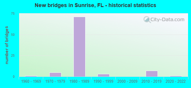
- New bridges - historical statistics
- 11960-1969
- 51970-1979
- 711980-1989
- 31990-1999
- 72010-2019
- 12020-2022
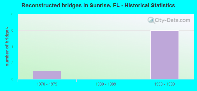
- Reconstructed bridges - Historical Statistics
- 11970-1979
- 01980-1989
- 61990-1999
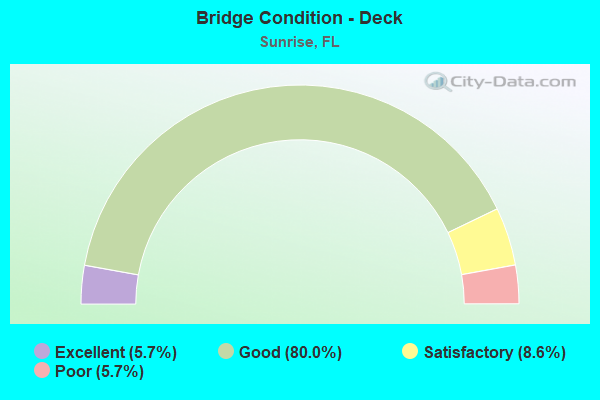
- Bridge Condition - Deck
- 5.7%Excellent
- 80.0%Good
- 8.6%Satisfactory
- 5.7%Poor
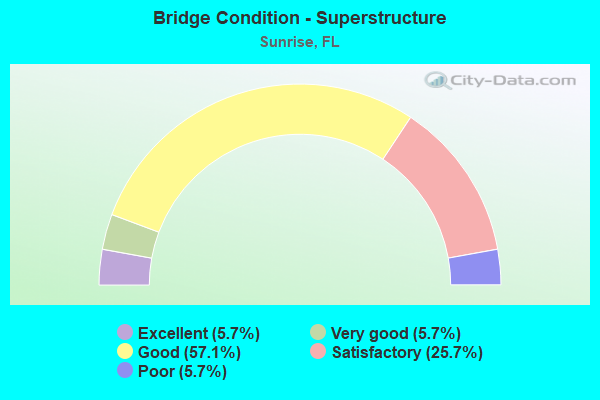
- Bridge Condition - Superstructure
- 5.7%Excellent
- 5.7%Very good
- 57.1%Good
- 25.7%Satisfactory
- 5.7%Poor
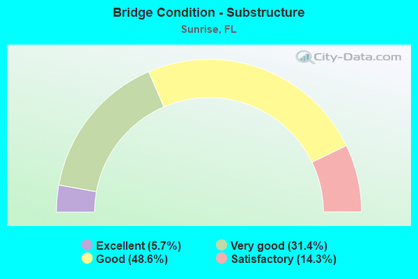
- Bridge Condition - Substructure
- 5.7%Excellent
- 31.4%Very good
- 48.6%Good
- 14.3%Satisfactory
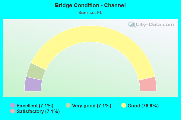
- Bridge Condition - Channel
- 7.1%Excellent
- 7.1%Very good
- 78.6%Good
- 7.1%Satisfactory
Find on map >> Show street view
Structure Number: 860387, Location: I-595 & I-75 INTERCHANGE (Lat: 26.119692, Lng: -80.343550), Route carried "under" structure: State highway 869, Year Built: 1986, Structure Length: 0. m, Average Daily Traffic: 40,000 (year 2022), Truck Traffic: 6%, Features Intersected: I-75 & I-75 Connectors, Facility Carried by Structure: I595 WB to I75 SB
Minimum Vertical Clearance: 5.30m (17.39ft), Kilometerpoint: 0.898, Lanes on structure: 2, Lanes under structure: 3, Material/Design: Prestressed concrete continuous, Design/Construction: Segmental Box Girder, Length of Maximum Span: 60.4m (198.2ft)
Find on map >> Show street view
Structure Number: 860387, Location: I-595 & I-75 INTERCHANGE (Lat: 26.119692, Lng: -80.343550), Route carried "under" structure: State highway 84, Year Built: 1986, Structure Length: 0. m, Average Daily Traffic: 9,300 (year 2022), Truck Traffic: 7%, Features Intersected: I-75 & I-75 Connectors, Facility Carried by Structure: I595 WB to I75 SB
Minimum Vertical Clearance: 8.26m (27.10ft), Kilometerpoint: 7.194, Lanes on structure: 2, Lanes under structure: 3, Material/Design: Prestressed concrete continuous, Design/Construction: Segmental Box Girder, Length of Maximum Span: 60.4m (198.2ft)
Find on map >> Show street view
Structure Number: 860482, Location: 2.2 MI S OF OAKLND PK BLV (Lat: 26.146708, Lng: -80.341689), Route carried "under" structure: State highway 838, Year Built: 1986, Structure Length: 0. m, Average Daily Traffic: 53,500 (year 2022), Truck Traffic: 8%, Features Intersected: SR 838 SUNRISE BLVD, Facility Carried by Structure: SR869 NB SAW 1.04
Minimum Vertical Clearance: 5.12m (16.80ft), Kilometerpoint: 1.674, Lanes on structure: 3, Lanes under structure: 4, Material/Design: Prestressed concrete, Design/Construction: Stringer/Multi-beam, Length of Maximum Span: 26.1m (85.6ft)
Find on map >> Show street view
Structure Number: 860483, Location: 2.2 MI S of Oakland Blvd (Lat: 26.146861, Lng: -80.342025), Route carried "under" structure: State highway 838, Year Built: 1986, Structure Length: 0. m, Average Daily Traffic: 53,500 (year 2022), Truck Traffic: 8%, Features Intersected: SR 838 SUNRISE BLVD, Facility Carried by Structure: SR869 SB SAW 1.04
Minimum Vertical Clearance: 5.12m (16.80ft), Kilometerpoint: 1.674, Lanes on structure: 3, Lanes under structure: 4, Material/Design: Prestressed concrete, Design/Construction: Stringer/Multi-beam, Length of Maximum Span: 26.1m (85.6ft)
Find on map >> Show street view
Structure Number: 860484, Location: INTER SR-869 AND SR-816 (Lat: 26.170008, Lng: -80.316972), Route carried "under" structure: State highway 816, Year Built: 1986, Structure Length: 0. m, Average Daily Traffic: 45,800 (year 2022), Truck Traffic: 8%, Features Intersected: SR 816 OAKLAND PK BLVD, Facility Carried by Structure: SR869 NB SAW 3.27
Minimum Vertical Clearance: 5.18m (16.99ft), Kilometerpoint: 5.251, Lanes on structure: 3, Lanes under structure: 4, Material/Design: Prestressed concrete, Design/Construction: Stringer/Multi-beam, Length of Maximum Span: 26.1m (85.6ft)
Find on map >> Show street view
Structure Number: 860485, Location: INTER. SR-869 AND SR-816 (Lat: 26.170253, Lng: -80.317231), Route carried "under" structure: State highway 816, Year Built: 1986, Structure Length: 0. m, Average Daily Traffic: 45,800 (year 2022), Truck Traffic: 8%, Features Intersected: SR 816 OAKLAND PK BLVD, Facility Carried by Structure: SR869 SB SAW 3.27
Minimum Vertical Clearance: 5.18m (16.99ft), Kilometerpoint: 5.251, Lanes on structure: 3, Lanes under structure: 4, Material/Design: Prestressed concrete, Design/Construction: Stringer/Multi-beam, Length of Maximum Span: 26.1m (85.6ft)
Find on map >> Show street view
Structure Number: 860486, Location: INTER SR-869 AND SR-870 (Lat: 26.193742, Lng: -80.294972), Route carried "under" structure: State highway 870, Year Built: 1986, Structure Length: 0. m, Average Daily Traffic: 41,850 (year 2022), Truck Traffic: 8%, Features Intersected: SR 870 COMMERCIAL BLVD, Facility Carried by Structure: SR869 SB SAW 5.46
Minimum Vertical Clearance: 5.36m (17.59ft), Kilometerpoint: 8.756, Lanes on structure: 3, Lanes under structure: 4, Material/Design: Prestressed concrete, Design/Construction: Stringer/Multi-beam, Length of Maximum Span: 24.7m (81.0ft)
Find on map >> Show street view
Structure Number: 860487, Location: INTERS.SR-869 AND SR-870 (Lat: 26.193711, Lng: -80.294594), Route carried "under" structure: State highway 870, Year Built: 1986, Structure Length: 0. m, Average Daily Traffic: 41,850 (year 2022), Truck Traffic: 8%, Features Intersected: SR 870 COMMERCIAL BLVD, Facility Carried by Structure: SR869 NB SAW 5.46
Minimum Vertical Clearance: 5.39m (17.68ft), Kilometerpoint: 8.756, Lanes on structure: 3, Lanes under structure: 4, Material/Design: Prestressed concrete, Design/Construction: Stringer/Multi-beam, Length of Maximum Span: 24.7m (81.0ft)
Find on map >> Show street view
Structure Number: 860509, Location: I-595/I-75 INTERCHANGE (Lat: 26.122917, Lng: -80.345694), Route carried "under" structure: State highway 84, Year Built: 1989, Structure Length: 0. m, Average Daily Traffic: 8,200 (year 2020), Truck Traffic: 4%, Features Intersected: SR-84 WB & NEW RIVER, Facility Carried by Structure: SR-869SB to I-75NB
Minimum Vertical Clearance: 5.09m (16.70ft), Kilometerpoint: 12.340, Lanes on structure: 2, Lanes under structure: 2, Material/Design: Prestressed concrete continuous, Design/Construction: Segmental Box Girder, Length of Maximum Span: 52.4m (171.9ft)
Find on map >> Show street view
Structure Number: 860511, Location: I-75 & I-595 Interchange (Lat: 26.120856, Lng: -80.344992), Route carried "under" structure: Ramp Interstate 75, Year Built: 1989, Structure Length: 0. m, Average Daily Traffic: 7,800 (year 2020), Truck Traffic: 8%, Features Intersected: I-75 Cnctrs & New River, Facility Carried by Structure: SB-869 To EB I-595
Minimum Vertical Clearance: 13.14m (43.11ft), Kilometerpoint: 0.108, Lanes on structure: 2, Lanes under structure: 2, Material/Design: Prestressed concrete continuous, Design/Construction: Segmental Box Girder, Length of Maximum Span: 59.5m (195.2ft)
Find on map >> Show street view
Structure Number: 860511, Location: I-75 & I-595 Interchange (Lat: 26.120856, Lng: -80.344992), Route carried "under" structure: Ramp Interstate 75, Year Built: 1989, Structure Length: 0. m, Average Daily Traffic: 31,000 (year 2020), Truck Traffic: 10%, Features Intersected: I-75 Cnctrs & New River, Facility Carried by Structure: SB-869 To EB I-595
Minimum Vertical Clearance: 8.50m (27.89ft), Kilometerpoint: 1.242, Lanes on structure: 2, Lanes under structure: 2, Material/Design: Prestressed concrete continuous, Design/Construction: Segmental Box Girder, Length of Maximum Span: 59.5m (195.2ft)
Find on map >> Show street view
Structure Number: 860511, Location: I-75 & I-595 Interchange (Lat: 26.120856, Lng: -80.344992), Route carried "under" structure: Ramp Interstate 75, Year Built: 1989, Structure Length: 0. m, Average Daily Traffic: 39,500 (year 2018), Truck Traffic: 6%, Features Intersected: I-75 Cnctrs & New River, Facility Carried by Structure: SB-869 To EB I-595
Minimum Vertical Clearance: 8.60m (28.22ft), Kilometerpoint: 0.355, Lanes on structure: 2, Lanes under structure: 3, Material/Design: Prestressed concrete continuous, Design/Construction: Segmental Box Girder, Length of Maximum Span: 59.5m (195.2ft)
Find on map >> Show street view
Structure Number: 860511, Location: I-75 & I-595 Interchange (Lat: 26.120856, Lng: -80.344992), Route carried "under" structure: Ramp Interstate 75, Year Built: 1989, Structure Length: 0. m, Average Daily Traffic: 8,400 (year 2020), Truck Traffic: 8%, Features Intersected: I-75 Cnctrs & New River, Facility Carried by Structure: SB-869 To EB I-595
Minimum Vertical Clearance: 5.09m (16.70ft), Kilometerpoint: 0.632, Lanes on structure: 2, Lanes under structure: 2, Material/Design: Prestressed concrete continuous, Design/Construction: Segmental Box Girder, Length of Maximum Span: 59.5m (195.2ft)
Find on map >> Show street view
Structure Number: 860511, Location: I-75 & I-595 Interchange (Lat: 26.120856, Lng: -80.344992), Route carried "under" structure: Ramp Interstate 75, Year Built: 1989, Structure Length: 0. m, Average Daily Traffic: 40,000 (year 2020), Truck Traffic: 6%, Features Intersected: I-75 Cnctrs & New River, Facility Carried by Structure: SB-869 To EB I-595
Minimum Vertical Clearance: 5.09m (16.70ft), Kilometerpoint: 0.611, Lanes on structure: 2, Lanes under structure: 3, Material/Design: Prestressed concrete continuous, Design/Construction: Segmental Box Girder, Length of Maximum Span: 59.5m (195.2ft)
Find on map >> Show street view
Structure Number: 860511, Location: I-75 & I-595 Interchange (Lat: 26.120856, Lng: -80.344992), Route carried "under" structure: Ramp Interstate 75, Year Built: 1989, Structure Length: 0. m, Average Daily Traffic: 25,500 (year 2020), Truck Traffic: 12%, Features Intersected: I-75 Cnctrs & New River, Facility Carried by Structure: SB-869 To EB I-595
Minimum Vertical Clearance: 8.05m (26.41ft), Kilometerpoint: 0.280, Lanes on structure: 2, Lanes under structure: 2, Material/Design: Prestressed concrete continuous, Design/Construction: Segmental Box Girder, Length of Maximum Span: 59.5m (195.2ft)
Find on map >> Show street view
Structure Number: 860511, Location: I-75 & I-595 Interchange (Lat: 26.120856, Lng: -80.344992), Route carried "under" structure: Ramp Interstate 75, Year Built: 1989, Structure Length: 0. m, Average Daily Traffic: 30,000 (year 2020), Truck Traffic: 8%, Features Intersected: I-75 Cnctrs & New River, Facility Carried by Structure: SB-869 To EB I-595
Minimum Vertical Clearance: 5.94m (19.49ft), Kilometerpoint: 0.655, Lanes on structure: 2, Lanes under structure: 3, Material/Design: Prestressed concrete continuous, Design/Construction: Segmental Box Girder, Length of Maximum Span: 59.5m (195.2ft)
Find on map >> Show street view
Structure Number: 860511, Location: I-75 & I-595 Interchange (Lat: 26.120856, Lng: -80.344992), Route carried "under" structure: Ramp Interstate 75, Year Built: 1989, Structure Length: 0. m, Average Daily Traffic: 162,500 (year 2017), Truck Traffic: 6%, Features Intersected: I-75 Cnctrs & New River, Facility Carried by Structure: SB-869 To EB I-595
Minimum Vertical Clearance: 6.25m (20.51ft), Kilometerpoint: 0.355, Lanes on structure: 2, Lanes under structure: 2, Toll: On toll road, Material/Design: Prestressed concrete continuous, Design/Construction: Segmental Box Girder, Length of Maximum Span: 59.5m (195.2ft)
Find on map >> Show street view
Structure Number: 860512, Location: I-75 & I-595 INTERCHANGE (Lat: 26.120556, Lng: -80.347472), Route carried "under" structure: Ramp Interstate 75, Year Built: 1989, Structure Length: 0. m, Average Daily Traffic: 16,000 (year 2020), Truck Traffic: 12%, Features Intersected: I-75 CONNCTRS &NEW RIVER
Minimum Vertical Clearance: 5.09m (16.70ft), Kilometerpoint: 1.590, Lanes on structure: 2, Lanes under structure: 2, Material/Design: Prestressed concrete continuous, Design/Construction: Segmental Box Girder, Length of Maximum Span: 62.8m (206.0ft)
Find on map >> Show street view
Structure Number: 860512, Location: I-75 & I-595 INTERCHANGE (Lat: 26.120556, Lng: -80.347472), Route carried "under" structure: Ramp Interstate 75, Year Built: 1989, Structure Length: 0. m, Average Daily Traffic: 30,000 (year 2020), Truck Traffic: 8%, Features Intersected: I-75 CONNCTRS &NEW RIVER
Minimum Vertical Clearance: 5.03m (16.50ft), Kilometerpoint: 1.215, Lanes on structure: 2, Lanes under structure: 3, Material/Design: Prestressed concrete continuous, Design/Construction: Segmental Box Girder, Length of Maximum Span: 62.8m (206.0ft)
Find on map >> Show street view
Structure Number: 860512, Location: I-75 & I-595 INTERCHANGE (Lat: 26.120556, Lng: -80.347472), Route carried "under" structure: Interstate 75, Year Built: 1989, Structure Length: 0. m, Average Daily Traffic: 52,500 (year 2020), Truck Traffic: 7%, Features Intersected: I-75 CONNCTRS &NEW RIVER
Minimum Vertical Clearance: 5.09m (16.70ft), Kilometerpoint: 19.401, Lanes on structure: 2, Lanes under structure: 6, Material/Design: Prestressed concrete continuous, Design/Construction: Segmental Box Girder, Length of Maximum Span: 62.8m (206.0ft)
Find on map >> Show street view
Structure Number: 860512, Location: I-75 & I-595 INTERCHANGE (Lat: 26.120556, Lng: -80.347472), Route carried "under" structure: Ramp Interstate 75, Year Built: 1989, Structure Length: 0. m, Average Daily Traffic: 40,000 (year 2020), Truck Traffic: 6%, Features Intersected: I-75 CONNCTRS &NEW RIVER
Minimum Vertical Clearance: 5.06m (16.60ft), Kilometerpoint: 1.197, Lanes on structure: 2, Lanes under structure: 3, Material/Design: Prestressed concrete continuous, Design/Construction: Segmental Box Girder, Length of Maximum Span: 62.8m (206.0ft)
Find on map >> Show street view
Structure Number: 860512, Location: I-75 & I-595 INTERCHANGE (Lat: 26.120556, Lng: -80.347472), Route carried "under" structure: Ramp Interstate 75, Year Built: 1989, Structure Length: 0. m, Average Daily Traffic: 13,000 (year 2020), Truck Traffic: 10%, Features Intersected: I-75 CONNCTRS &NEW RIVER
Minimum Vertical Clearance: 5.18m (16.99ft), Kilometerpoint: 0.724, Lanes on structure: 2, Lanes under structure: 2, Material/Design: Prestressed concrete continuous, Design/Construction: Segmental Box Girder, Length of Maximum Span: 62.8m (206.0ft)
Find on map >> Show street view
Structure Number: 860512, Location: I-75 & I-595 INTERCHANGE (Lat: 26.120556, Lng: -80.347472), Route carried "under" structure: State highway 84, Year Built: 1989, Structure Length: 0. m, Average Daily Traffic: 8,200 (year 2020), Truck Traffic: 4%, Features Intersected: I-75 CONNCTRS &NEW RIVER, Facility Carried by Structure: I-75 SB TO 869 NB
Minimum Vertical Clearance: 5.09m (16.70ft), Kilometerpoint: 12.134, Lanes on structure: 2, Lanes under structure: 2, Material/Design: Prestressed concrete continuous, Design/Construction: Segmental Box Girder, Length of Maximum Span: 62.8m (206.0ft)
Find on map >> Show street view
Structure Number: 860515, Location: I-595/I-75 INTERCHANGE (Lat: 26.117119, Lng: -80.348947), Route carried "under" structure: Interstate 75, Year Built: 1988, Structure Length: 0. m, Average Daily Traffic: 26,250 (year 2020), Truck Traffic: 7%, Features Intersected: SR-93(I-75) NB
Minimum Vertical Clearance: 5.06m (16.60ft), Kilometerpoint: 19.003, Lanes on structure: 3, Lanes under structure: 3, Material/Design: Prestressed concrete continuous, Design/Construction: Segmental Box Girder, Length of Maximum Span: 55.8m (183.1ft)
Find on map >> Show street view
Structure Number: 860516, Location: I-595&I-75 INTERCHANGE (Lat: 26.119694, Lng: -80.346972), Route carried "under" structure: Interstate 75, Year Built: 1988, Structure Length: 0. m, Average Daily Traffic: 16,000 (year 2020), Truck Traffic: 12%, Features Intersected: I75 connectors&EB SR-84
Minimum Vertical Clearance: 8.60m (28.22ft), Kilometerpoint: 1.576, Lanes on structure: 3, Lanes under structure: 2, Material/Design: Prestressed concrete continuous, Design/Construction: Segmental Box Girder, Length of Maximum Span: 51.8m (169.9ft)
Find on map >> Show street view
Structure Number: 860516, Location: I-595&I-75 INTERCHANGE (Lat: 26.119694, Lng: -80.346972), Route carried "under" structure: Ramp Interstate 75, Year Built: 1988, Structure Length: 0. m, Average Daily Traffic: 6,500 (year 2020), Truck Traffic: 13%, Features Intersected: I75 connectors&EB SR-84
Minimum Vertical Clearance: 5.09m (16.70ft), Kilometerpoint: 1.775, Lanes on structure: 3, Lanes under structure: 2, Material/Design: Prestressed concrete continuous, Design/Construction: Segmental Box Girder, Length of Maximum Span: 51.8m (169.9ft)
Find on map >> Show street view
Structure Number: 860516, Location: I-595&I-75 INTERCHANGE (Lat: 26.119694, Lng: -80.346972), Route carried "under" structure: State highway 84, Year Built: 1988, Structure Length: 0. m, Average Daily Traffic: 9,300 (year 2020), Truck Traffic: 3%, Features Intersected: I75 connectors&EB SR-84, Facility Carried by Structure: SB 869 TO SB I-75
Minimum Vertical Clearance: 5.09m (16.70ft), Kilometerpoint: 7.578, Lanes on structure: 3, Lanes under structure: 2, Material/Design: Prestressed concrete continuous, Design/Construction: Segmental Box Girder, Length of Maximum Span: 51.8m (169.9ft)
Find on map >> Show street view
Structure Number: 860517, Location: I-595 / I-75 Interchange (Lat: 26.122753, Lng: -80.345139), Route carried "under" structure: State highway 84, Year Built: 1988, Structure Length: 0. m, Average Daily Traffic: 8,200 (year 2020), Truck Traffic: 4%, Features Intersected: WB SR-84 & N. New River, Facility Carried by Structure: SB 869 to SB I-75
Minimum Vertical Clearance: 6.77m (22.21ft), Kilometerpoint: 12.258, Lanes on structure: 3, Lanes under structure: 2, Material/Design: Prestressed concrete continuous, Design/Construction: Segmental Box Girder, Length of Maximum Span: 42.7m (140.1ft)
Find on map >> Show street view
Structure Number: 860518, Location: I-75 & I-595 INTERCHANGE (Lat: 26.119306, Lng: -80.345222), Route carried "under" structure: State highway 84, Year Built: 1988, Structure Length: 0. m, Average Daily Traffic: 9,300 (year 2022), Truck Traffic: 3%, Features Intersected: EB SR84 & I75 Connectors, Facility Carried by Structure: NB I-75 TO NBSR869
Minimum Vertical Clearance: 5.06m (16.60ft), Kilometerpoint: 7.770, Lanes on structure: 3, Lanes under structure: 3, Material/Design: Prestressed concrete continuous, Design/Construction: Segmental Box Girder, Length of Maximum Span: 40.2m (131.9ft)
Find on map >> Show street view
Structure Number: 860518, Location: I-75 & I-595 INTERCHANGE (Lat: 26.119306, Lng: -80.345222), Route carried "under" structure: Ramp State highway 84, Year Built: 1988, Structure Length: 0. m, Average Daily Traffic: 11,000 (year 2022), Truck Traffic: 7%, Features Intersected: EB SR84 & I75 Connectors, Facility Carried by Structure: NB I-75 TO NBSR869
Minimum Vertical Clearance: 5.27m (17.29ft), Kilometerpoint: 0.002, Lanes on structure: 3, Lanes under structure: 1, Material/Design: Prestressed concrete continuous, Design/Construction: Segmental Box Girder, Length of Maximum Span: 40.2m (131.9ft)
Find on map >> Show street view
Structure Number: 860518, Location: I-75 & I-595 INTERCHANGE (Lat: 26.119306, Lng: -80.345222), Route carried "under" structure: Interstate 75, Year Built: 1988, Structure Length: 0. m, Average Daily Traffic: 13,000 (year 2022), Truck Traffic: 13%, Features Intersected: EB SR84 & I75 Connectors
Minimum Vertical Clearance: 4.94m (16.21ft), Kilometerpoint: 1.777, Lanes on structure: 3, Lanes under structure: 2, Material/Design: Prestressed concrete continuous, Design/Construction: Segmental Box Girder, Length of Maximum Span: 40.2m (131.9ft)
Find on map >> Show street view
Structure Number: 860518, Location: I-75 & I-595 INTERCHANGE (Lat: 26.119306, Lng: -80.345222), Route carried "under" structure: Ramp Interstate 75, Year Built: 1988, Structure Length: 0. m, Average Daily Traffic: 16,000 (year 2022), Truck Traffic: 12%, Features Intersected: EB SR84 & I75 Connectors
Minimum Vertical Clearance: 6.04m (19.82ft), Kilometerpoint: 1.423, Lanes on structure: 3, Lanes under structure: 2, Material/Design: Prestressed concrete continuous, Design/Construction: Segmental Box Girder, Length of Maximum Span: 40.2m (131.9ft)
Find on map >> Show street view
Structure Number: 860518, Location: I-75 & I-595 INTERCHANGE (Lat: 26.119306, Lng: -80.345222), Route carried "under" structure: Other road 595, Year Built: 1988, Structure Length: 0. m, Average Daily Traffic: 2,000 (year 2022), Truck Traffic: 10%, Features Intersected: EB SR84 & I75 Connectors, Facility Carried by Structure: NB I-75 TO NBSR869
Minimum Vertical Clearance: 5.06m (16.60ft), Kilometerpoint: 0.000, Lanes on structure: 3, Lanes under structure: 1, Toll: On toll road, Material/Design: Prestressed concrete continuous, Design/Construction: Segmental Box Girder, Length of Maximum Span: 40.2m (131.9ft)
Find on map >> Show street view
Structure Number: 860518, Location: I-75 & I-595 INTERCHANGE (Lat: 26.119306, Lng: -80.345222), Route carried "under" structure: Other road 595, Year Built: 1988, Structure Length: 0. m, Average Daily Traffic: 200 (year 2022), Truck Traffic: 10%, Features Intersected: EB SR84 & I75 Connectors, Facility Carried by Structure: NB I-75 TO NBSR869
Minimum Vertical Clearance: 5.06m (16.60ft), Kilometerpoint: 0.000, Lanes on structure: 3, Lanes under structure: 1, Toll: On toll road, Material/Design: Prestressed concrete continuous, Design/Construction: Segmental Box Girder, Length of Maximum Span: 40.2m (131.9ft)
Find on map >> Show street view
Structure Number: 860671, Location: 4.0 Mi N of SR-818 (Lat: 26.118567, Lng: -80.346775), Route carried "under" structure: Ramp Interstate 75, Year Built: 2014, Structure Length: 0. m, Average Daily Traffic: 40,000 (year 2020), Truck Traffic: 6%, Features Intersected: I75 SR84 & SR869
Minimum Vertical Clearance: 5.09m (16.70ft), Kilometerpoint: 0.819, Lanes on structure: 2, Lanes under structure: 3, Material/Design: Prestressed concrete, Design/Construction: Stringer/Multi-beam, Length of Maximum Span: 48.8m (160.1ft)
Find on map >> Show street view
Structure Number: 860671, Location: 4.0 Mi N of SR-818 (Lat: 26.118567, Lng: -80.346775), Route carried "under" structure: Ramp State highway 84, Year Built: 2014, Structure Length: 0. m, Average Daily Traffic: 8,400 (year 2017), Truck Traffic: 2%, Features Intersected: I75 SR84 & SR869, Facility Carried by Structure: I-75 to I-595 RvLn
Minimum Vertical Clearance: 14.51m (47.60ft), Kilometerpoint: 0.000, Lanes on structure: 2, Lanes under structure: 1, Material/Design: Prestressed concrete, Design/Construction: Stringer/Multi-beam, Length of Maximum Span: 48.8m (160.1ft)
Find on map >> Show street view
Structure Number: 860671, Location: 4.0 Mi N of SR-818 (Lat: 26.118567, Lng: -80.346775), Route carried "under" structure: Interstate 75, Year Built: 2014, Structure Length: 0. m, Average Daily Traffic: 26,250 (year 2020), Truck Traffic: 7%, Features Intersected: I75 SR84 & SR869
Minimum Vertical Clearance: 5.07m (16.63ft), Kilometerpoint: 18.984, Lanes on structure: 2, Lanes under structure: 3, Material/Design: Prestressed concrete, Design/Construction: Stringer/Multi-beam, Length of Maximum Span: 48.8m (160.1ft)
Find on map >> Show street view
Structure Number: 860671, Location: 4.0 Mi N of SR-818 (Lat: 26.118567, Lng: -80.346775), Route carried "under" structure: State highway 84, Year Built: 2014, Structure Length: 0. m, Average Daily Traffic: 9,300 (year 2020), Truck Traffic: 3%, Features Intersected: I75 SR84 & SR869, Facility Carried by Structure: I-75 to I-595 RvLn
Minimum Vertical Clearance: 12.80m (41.99ft), Kilometerpoint: 7.662, Lanes on structure: 2, Lanes under structure: 2, Material/Design: Prestressed concrete, Design/Construction: Stringer/Multi-beam, Length of Maximum Span: 48.8m (160.1ft)
Find on map >> Show street view
Structure Number: 861, Location: 0.4 MI N OF SAWGRASS TOLL (Lat: 26.161469, Lng: -80.327567), Route carried "under" structure: State highway 869, Year Built: 1998, Structure Length: 0. m, Average Daily Traffic: 92,800 (year 2021), Truck Traffic: 8%, Features Intersected: SR-869 & PANTHER DR
Minimum Vertical Clearance: 5.06m (16.60ft), Kilometerpoint: 3.903, Lanes on structure: 2, Lanes under structure: 7, Toll: On toll road, Material/Design: Steel continuous, Design/Construction: Box Beam or Girders - Single/Spread, Length of Maximum Span: 63.4m (208.0ft)