Bridge Statistics for Sunrise, Florida (FL)
Condition, Traffic, Stress, Structural Evaluation, Project Costs
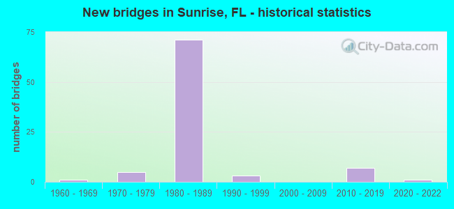
- New bridges - historical statistics
- 11960-1969
- 51970-1979
- 711980-1989
- 31990-1999
- 72010-2019
- 12020-2022
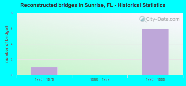
- Reconstructed bridges - Historical Statistics
- 11970-1979
- 01980-1989
- 61990-1999
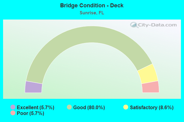
- Bridge Condition - Deck
- 5.7%Excellent
- 80.0%Good
- 8.6%Satisfactory
- 5.7%Poor
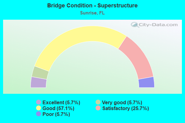
- Bridge Condition - Superstructure
- 5.7%Excellent
- 5.7%Very good
- 57.1%Good
- 25.7%Satisfactory
- 5.7%Poor
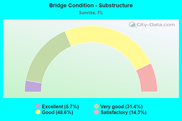
- Bridge Condition - Substructure
- 5.7%Excellent
- 31.4%Very good
- 48.6%Good
- 14.3%Satisfactory
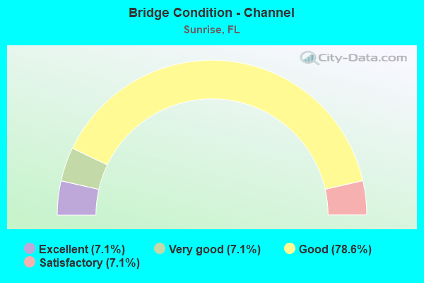
- Bridge Condition - Channel
- 7.1%Excellent
- 7.1%Very good
- 78.6%Good
- 7.1%Satisfactory
Find on map >> Show street view
Structure Number: 860163, Location: 1000' S SR816 (Oakland) (Lat: 26.164417, Lng: -80.256933), Route carried "on" structure: State highway 817, Year Built: 1971, Year Reconstructed: 1981, Status: Open, Structure Length: 2.35m (7.71ft), Average Daily Traffic: 45,500 (year 2020), Truck Traffic: 5%, Average Future Daily Traffic: 78,942 (year 2042), Design Load: HS 20, Features Intersected: C-13 Canal
Minimum Vertical Clearance: 30+ m (98+ ft), Kilometerpoint: 21.575, Lanes on structure: 6, Base Highway Network: Yes, Owner: State Highway Agency, Approaching Roadway Width: 30.2m (99.1ft), Skew: 20 degrees, Material/Design: Concrete, Design/Construction: Slab, Number Of Spans In Main Unit: 3, Length of Maximum Span: 8.5m (27.9ft), Curb or Sidewalk Widths: Left: 1.5m (4.9ft), Right: 1.5m (4.9ft), Curb-To-Curb Width: 30.2m (99.1ft), Out-to-Out Width: 34.1m (111.9ft)
Condition: Deck: Good, Superstructure: Good, Substructure: Good, Channel: Satisfactory, Operating Rating: 53.5 metric tons, Method Used To Determine Operating Rating: Load Factor (LF), Inventory Rating: 31.8 metric tons, Method Used To Determine Inventory Rating: Load Factor (LF), Structural Evaluation: Better than present minimum criteria, Deck Geometry: Superior to present desirable criteria, Waterway Adequacy: Better than present minimum criteria, Approach Roadway Alignment: Equal to present desirable criteria, Designated Inspection Frequency: Every 24 months, Underwater Inspection Frequency: Every 24 months, Inspection Date: April 2020, Underwater Inspection Date: April 2020, Deck Structure Type: Concrete Cast-file-Place
Find on map >> Show street view
Structure Number: 86038, Location: 0.5MI S OF BONAVENTURE BL (Lat: 26.125475, Lng: -80.360381), Route carried "on" structure: Interstate 75, Year Built: 1986, Status: Open, Structure Length: 9.02m (29.59ft), Average Daily Traffic: 26,250 (year 2020), Truck Traffic: 7%, Average Future Daily Traffic: 45,544 (year 2042), Design Load: HS 20+Mod, Features Intersected: WESTON RD
Minimum Vertical Clearance: 30+ m (98+ ft), Kilometerpoint: 20.579, Lanes on structure: 6, Lanes under structure: 5, Base Highway Network: Yes, Owner: State Highway Agency, Approaching Roadway Width: 26.5m (86.9ft), Material/Design: Prestressed concrete, Design/Construction: Stringer/Multi-beam, Number Of Spans In Main Unit: 3, Length of Maximum Span: 31.6m (103.7ft), Curb-To-Curb Width: 28.0m (91.9ft), Out-to-Out Width: 29.1m (95.5ft)
Condition: Deck: Good, Superstructure: Very good, Substructure: Very good, Operating Rating: 60.8 metric tons, Method Used To Determine Operating Rating: Load Factor (LF), Inventory Rating: 53.6 metric tons, Method Used To Determine Inventory Rating: Load Factor (LF), Structural Evaluation: Equal to present desirable criteria, Deck Geometry: Equal to present minimum criteria, Underclear: Equal to present minimum criteria, Approach Roadway Alignment: Equal to present desirable criteria, Designated Inspection Frequency: Every 24 months, Inspection Date: September 2020, Deck Structure Type: Concrete Cast-file-Place
Find on map >> Show street view
Structure Number: 860381, Location: 0.5MI S OF BONAVENTURE BL (Lat: 26.125158, Lng: -80.360475), Route carried "on" structure: Interstate 75, Year Built: 1986, Status: Open, Structure Length: 9.00m (29.53ft), Average Daily Traffic: 26,250 (year 2020), Truck Traffic: 7%, Average Future Daily Traffic: 45,544 (year 2042), Design Load: HS 20+Mod, Features Intersected: WESTON ROAD
Minimum Vertical Clearance: 30+ m (98+ ft), Kilometerpoint: 20.579, Lanes on structure: 3, Lanes under structure: 5, Base Highway Network: Yes, Owner: State Highway Agency, Approaching Roadway Width: 17.0m (55.8ft), Material/Design: Prestressed concrete, Design/Construction: Stringer/Multi-beam, Number Of Spans In Main Unit: 3, Length of Maximum Span: 31.7m (104.0ft), Curb-To-Curb Width: 17.0m (55.8ft), Out-to-Out Width: 18.0m (59.1ft)
Condition: Deck: Good, Superstructure: Good, Substructure: Very good, Operating Rating: 61.2 metric tons, Method Used To Determine Operating Rating: Load Factor (LF), Inventory Rating: 55.1 metric tons, Method Used To Determine Inventory Rating: Load Factor (LF), Structural Evaluation: Better than present minimum criteria, Deck Geometry: Equal to present minimum criteria, Underclear: Equal to present minimum criteria, Approach Roadway Alignment: Equal to present desirable criteria, Designated Inspection Frequency: Every 24 months, Inspection Date: September 2020, Deck Structure Type: Concrete Cast-file-Place
Find on map >> Show street view
Structure Number: 860382, Location: 0.5MI S of BONAVENTURE BL (Lat: 26.124917, Lng: -80.360556), Route carried "on" structure: Ramp Interstate 75, Year Built: 1986, Status: Open, Structure Length: 8.99m (29.49ft), Average Daily Traffic: 13,000 (year 2020), Truck Traffic: 10%, Average Future Daily Traffic: 22,555 (year 2042), Design Load: HS 20+Mod, Features Intersected: WESTON RD
Minimum Vertical Clearance: 30+ m (98+ ft), Kilometerpoint: 0.079, Lanes on structure: 3, Lanes under structure: 5, Owner: State Highway Agency, Approaching Roadway Width: 15.7m (51.5ft), Skew: 1 degrees, Material/Design: Prestressed concrete, Design/Construction: Stringer/Multi-beam, Number Of Spans In Main Unit: 3, Length of Maximum Span: 32.0m (105.0ft), Curb-To-Curb Width: 17.0m (55.8ft), Out-to-Out Width: 17.9m (58.7ft)
Condition: Deck: Good, Superstructure: Good, Substructure: Good, Operating Rating: 82.3 metric tons, Method Used To Determine Operating Rating: Load Factor (LF), Inventory Rating: 49.3 metric tons, Method Used To Determine Inventory Rating: Load Factor (LF), Structural Evaluation: Better than present minimum criteria, Deck Geometry: Superior to present desirable criteria, Underclear: Equal to present minimum criteria, Approach Roadway Alignment: Equal to present desirable criteria, Designated Inspection Frequency: Every 24 months, Inspection Date: September 2020, Deck Structure Type: Concrete Cast-file-Place
Find on map >> Show street view
Structure Number: 860385, Location: I-595 & I-75 INTERCHANGE (Lat: 26.120361, Lng: -80.350778), Route carried "on" structure: Ramp Interstate 75, Year Built: 1986, Status: Open, Structure Length: 34.05m (111.71ft), Average Daily Traffic: 13,000 (year 2022), Truck Traffic: 13%, Average Future Daily Traffic: 22,555 (year 2042), Features Intersected: I-75 (SR-93)
Minimum Vertical Clearance: 5.49m (18.01ft), Kilometerpoint: 1.035, Lanes on structure: 2, Lanes under structure: 6, Owner: State Highway Agency, Approaching Roadway Width: 12.2m (40.0ft), Material/Design: Prestressed concrete continuous, Design/Construction: Segmental Box Girder, Number Of Spans In Main Unit: 7, Length of Maximum Span: 61.0m (200.1ft), Curb-To-Curb Width: 12.2m (40.0ft), Out-to-Out Width: 13.0m (42.7ft)
Condition: Deck: Good, Superstructure: Good, Substructure: Good, Operating Rating: 54.4 metric tons, Method Used To Determine Operating Rating: Load Testing, Inventory Rating: 32.7 metric tons, Method Used To Determine Inventory Rating: Load Testing, Structural Evaluation: Better than present minimum criteria, Deck Geometry: Superior to present desirable criteria, Underclear: Equal to present desirable criteria, Approach Roadway Alignment: Equal to present desirable criteria, Designated Inspection Frequency: Every 24 months, Inspection Date: January 2022, Deck Structure Type: Concrete Cast-file-Place, Wearing Surface/Protective System: Wearing Surface: Epoxy Overlay
Find on map >> Show street view
Structure Number: 860386, Location: I-595 & I-75 Interchange (Lat: 26.119889, Lng: -80.350417), Route carried "on" structure: State highway 84, Year Built: 1986, Status: Open, Structure Length: 32.95m (108.10ft), Average Daily Traffic: 9,300 (year 2022), Truck Traffic: 3%, Average Future Daily Traffic: 16,136 (year 2042), Features Intersected: I-75 (SR-93)
Minimum Vertical Clearance: 30+ m (98+ ft), Kilometerpoint: 7.083, Lanes on structure: 2, Lanes under structure: 6, Owner: State Highway Agency, Approaching Roadway Width: 12.2m (40.0ft), Material/Design: Prestressed concrete continuous, Design/Construction: Segmental Box Girder, Number Of Spans In Main Unit: 7, Length of Maximum Span: 56.1m (184.1ft), Curb-To-Curb Width: 12.2m (40.0ft), Out-to-Out Width: 13.0m (42.7ft)
Condition: Deck: Good, Superstructure: Good, Substructure: Good, Operating Rating: 54.4 metric tons, Method Used To Determine Operating Rating: Load Testing, Inventory Rating: 32.7 metric tons, Method Used To Determine Inventory Rating: Load Testing, Structural Evaluation: Better than present minimum criteria, Deck Geometry: Better than present minimum criteria, Underclear: Superior to present desirable criteria, Approach Roadway Alignment: Equal to present desirable criteria, Designated Inspection Frequency: Every 24 months, Inspection Date: January 2022, Deck Structure Type: Concrete Cast-file-Place, Wearing Surface/Protective System: Wearing Surface: Epoxy Overlay
Find on map >> Show street view
Structure Number: 860387, Location: I-595 & I-75 INTERCHANGE (Lat: 26.119692, Lng: -80.343550), Route carried "on" structure: Ramp Interstate 75, Year Built: 1986, Status: Open, Structure Length: 86.31m (283.17ft), Average Daily Traffic: 25,500 (year 2022), Truck Traffic: 12%, Average Future Daily Traffic: 44,242 (year 2042), Design Load: HS 20+Mod, Features Intersected: I-75 & I-75 Connectors
Minimum Vertical Clearance: 8.05m (26.41ft), Kilometerpoint: 0.398, Lanes on structure: 2, Lanes under structure: 15, Owner: State Highway Agency, Approaching Roadway Width: 12.2m (40.0ft), Material/Design: Prestressed concrete continuous, Design/Construction: Segmental Box Girder, Number Of Spans In Main Unit: 17, Length of Maximum Span: 60.4m (198.2ft), Curb-To-Curb Width: 12.2m (40.0ft), Out-to-Out Width: 13.0m (42.7ft)
Condition: Deck: Satisfactory, Superstructure: Satisfactory, Substructure: Good, Operating Rating: 54.4 metric tons, Method Used To Determine Operating Rating: Load Testing, Inventory Rating: 32.7 metric tons, Method Used To Determine Inventory Rating: Load Testing, Structural Evaluation: Equal to present minimum criteria, Deck Geometry: Superior to present desirable criteria, Underclear: Meets minimum limits, Approach Roadway Alignment: Better than present minimum criteria, Designated Inspection Frequency: Every 24 months, Inspection Date: January 2022, Deck Structure Type: Concrete Cast-file-Place, Wearing Surface/Protective System: Wearing Surface: Epoxy Overlay
Find on map >> Show street view
Structure Number: 860482, Location: 2.2 MI S OF OAKLND PK BLV (Lat: 26.146708, Lng: -80.341689), Route carried "on" structure: State highway 869, Year Built: 1986, Year Reconstructed: 2003, Status: Open, Structure Length: 5.21m (17.09ft), Average Daily Traffic: 53,500 (year 2022), Truck Traffic: 8%, Average Future Daily Traffic: 92,822 (year 2042), Design Load: HS 20+Mod, Features Intersected: SR 838 SUNRISE BLVD
Minimum Vertical Clearance: 30+ m (98+ ft), Kilometerpoint: 1.680, Lanes on structure: 3, Lanes under structure: 4, Base Highway Network: Yes, Toll: On toll road, Owner: State Toll Authority, Approaching Roadway Width: 17.4m (57.1ft), Material/Design: Prestressed concrete, Design/Construction: Stringer/Multi-beam, Number Of Spans In Main Unit: 2, Length of Maximum Span: 26.1m (85.6ft), Curb-To-Curb Width: 17.1m (56.1ft), Out-to-Out Width: 18.0m (59.1ft)
Condition: Deck: Good, Superstructure: Good, Substructure: Very good, Operating Rating: 40.2 metric tons, Method Used To Determine Operating Rating: Load and Resistance Factor (LRFR), Inventory Rating: 33.3 metric tons, Method Used To Determine Inventory Rating: Load and Resistance Factor (LRFR), Structural Evaluation: Better than present minimum criteria, Deck Geometry: Equal to present minimum criteria, Underclear: Equal to present minimum criteria, Approach Roadway Alignment: Equal to present desirable criteria, Designated Inspection Frequency: Every 24 months, Inspection Date: January 2022, Deck Structure Type: Concrete Cast-file-Place
Find on map >> Show street view
Structure Number: 860483, Location: 2.2 MI S of Oakland Blvd (Lat: 26.146861, Lng: -80.342025), Route carried "on" structure: State highway 869, Year Built: 1986, Year Reconstructed: 2003, Status: Open, Structure Length: 5.21m (17.09ft), Average Daily Traffic: 53,500 (year 2022), Truck Traffic: 8%, Average Future Daily Traffic: 92,822 (year 2042), Design Load: HS 20+Mod, Features Intersected: SR 838 SUNRISE BLVD
Minimum Vertical Clearance: 30.45m (99.90ft), Kilometerpoint: 1.680, Lanes on structure: 3, Lanes under structure: 4, Base Highway Network: Yes, Toll: On toll road, Owner: State Toll Authority, Approaching Roadway Width: 17.4m (57.1ft), Material/Design: Prestressed concrete, Design/Construction: Stringer/Multi-beam, Number Of Spans In Main Unit: 2, Length of Maximum Span: 26.1m (85.6ft), Curb-To-Curb Width: 17.1m (56.1ft), Out-to-Out Width: 18.0m (59.1ft)
Condition: Deck: Good, Superstructure: Good, Substructure: Very good, Operating Rating: 40.2 metric tons, Method Used To Determine Operating Rating: Load and Resistance Factor (LRFR), Inventory Rating: 33.3 metric tons, Method Used To Determine Inventory Rating: Load and Resistance Factor (LRFR), Structural Evaluation: Better than present minimum criteria, Deck Geometry: Equal to present minimum criteria, Underclear: Equal to present minimum criteria, Approach Roadway Alignment: Equal to present desirable criteria, Designated Inspection Frequency: Every 24 months, Inspection Date: January 2022, Deck Structure Type: Concrete Cast-file-Place
Find on map >> Show street view
Structure Number: 860484, Location: INTER SR-869 AND SR-816 (Lat: 26.170008, Lng: -80.316972), Route carried "on" structure: State highway 869, Year Built: 1986, Year Reconstructed: 2003, Status: Open, Structure Length: 5.21m (17.09ft), Average Daily Traffic: 45,800 (year 2022), Truck Traffic: 8%, Average Future Daily Traffic: 79,463 (year 2042), Design Load: HS 20+Mod, Features Intersected: SR 816 OAKLAND PK BLVD
Minimum Vertical Clearance: 30+ m (98+ ft), Kilometerpoint: 5.266, Lanes on structure: 3, Lanes under structure: 4, Base Highway Network: Yes, Toll: On toll road, Owner: State Toll Authority, Approaching Roadway Width: 17.4m (57.1ft), Material/Design: Prestressed concrete, Design/Construction: Stringer/Multi-beam, Number Of Spans In Main Unit: 2, Length of Maximum Span: 26.1m (85.6ft), Curb-To-Curb Width: 17.1m (56.1ft), Out-to-Out Width: 18.0m (59.1ft)
Condition: Deck: Good, Superstructure: Good, Substructure: Very good, Operating Rating: 43.1 metric tons, Method Used To Determine Operating Rating: Load and Resistance Factor (LRFR), Inventory Rating: 33.3 metric tons, Method Used To Determine Inventory Rating: Load and Resistance Factor (LRFR), Structural Evaluation: Better than present minimum criteria, Deck Geometry: Equal to present minimum criteria, Underclear: Equal to present minimum criteria, Approach Roadway Alignment: Equal to present desirable criteria, Designated Inspection Frequency: Every 24 months, Inspection Date: January 2022, Deck Structure Type: Concrete Cast-file-Place
Find on map >> Show street view
Structure Number: 860485, Location: INTER. SR-869 AND SR-816 (Lat: 26.170253, Lng: -80.317231), Route carried "on" structure: State highway 869, Year Built: 1986, Year Reconstructed: 2003, Status: Open, Structure Length: 5.21m (17.09ft), Average Daily Traffic: 45,800 (year 2022), Truck Traffic: 8%, Average Future Daily Traffic: 79,463 (year 2042), Design Load: HS 20+Mod, Features Intersected: SR 816 OAKLAND PK BLVD
Minimum Vertical Clearance: 30+ m (98+ ft), Kilometerpoint: 5.266, Lanes on structure: 3, Lanes under structure: 4, Base Highway Network: Yes, Toll: On toll road, Owner: State Toll Authority, Approaching Roadway Width: 17.4m (57.1ft), Material/Design: Prestressed concrete, Design/Construction: Stringer/Multi-beam, Number Of Spans In Main Unit: 2, Length of Maximum Span: 26.1m (85.6ft), Curb-To-Curb Width: 17.1m (56.1ft), Out-to-Out Width: 18.0m (59.1ft)
Condition: Deck: Good, Superstructure: Good, Substructure: Very good, Operating Rating: 43.1 metric tons, Method Used To Determine Operating Rating: Load and Resistance Factor (LRFR), Inventory Rating: 33.3 metric tons, Method Used To Determine Inventory Rating: Load and Resistance Factor (LRFR), Structural Evaluation: Better than present minimum criteria, Deck Geometry: Equal to present minimum criteria, Underclear: Equal to present minimum criteria, Approach Roadway Alignment: Equal to present desirable criteria, Designated Inspection Frequency: Every 24 months, Inspection Date: January 2022, Deck Structure Type: Concrete Cast-file-Place
Find on map >> Show street view
Structure Number: 860486, Location: INTER SR-869 AND SR-870 (Lat: 26.193742, Lng: -80.294972), Route carried "on" structure: State highway 869, Year Built: 1986, Year Reconstructed: 2004, Status: Open, Structure Length: 4.94m (16.21ft), Average Daily Traffic: 41,850 (year 2022), Truck Traffic: 8%, Average Future Daily Traffic: 72,610 (year 2042), Design Load: HS 20+Mod, Features Intersected: SR 870 COMMERCIAL BLVD
Minimum Vertical Clearance: 30+ m (98+ ft), Kilometerpoint: 8.781, Lanes on structure: 3, Lanes under structure: 4, Base Highway Network: Yes, Toll: On toll road, Owner: State Toll Authority, Approaching Roadway Width: 17.4m (57.1ft), Material/Design: Prestressed concrete, Design/Construction: Stringer/Multi-beam, Number Of Spans In Main Unit: 2, Length of Maximum Span: 24.7m (81.0ft), Curb-To-Curb Width: 17.1m (56.1ft), Out-to-Out Width: 18.0m (59.1ft)
Condition: Deck: Good, Superstructure: Good, Substructure: Very good, Operating Rating: 40.2 metric tons, Method Used To Determine Operating Rating: Load and Resistance Factor (LRFR), Inventory Rating: 36.9 metric tons, Method Used To Determine Inventory Rating: Load and Resistance Factor (LRFR), Structural Evaluation: Better than present minimum criteria, Deck Geometry: Equal to present minimum criteria, Underclear: Equal to present minimum criteria, Approach Roadway Alignment: Equal to present desirable criteria, Designated Inspection Frequency: Every 24 months, Inspection Date: January 2022, Deck Structure Type: Concrete Cast-file-Place
Find on map >> Show street view
Structure Number: 860487, Location: INTERS.SR-869 AND SR-870 (Lat: 26.193711, Lng: -80.294594), Route carried "on" structure: State highway 869, Year Built: 1986, Year Reconstructed: 2004, Status: Open, Structure Length: 4.94m (16.21ft), Average Daily Traffic: 41,850 (year 2022), Truck Traffic: 8%, Average Future Daily Traffic: 72,610 (year 2042), Design Load: HS 20+Mod, Features Intersected: SR 870 COMMERCIAL BLVD
Minimum Vertical Clearance: 30+ m (98+ ft), Kilometerpoint: 8.781, Lanes on structure: 3, Lanes under structure: 4, Base Highway Network: Yes, Toll: On toll road, Owner: State Toll Authority, Approaching Roadway Width: 17.4m (57.1ft), Material/Design: Prestressed concrete, Design/Construction: Stringer/Multi-beam, Number Of Spans In Main Unit: 2, Length of Maximum Span: 24.7m (81.0ft), Curb-To-Curb Width: 17.1m (56.1ft), Out-to-Out Width: 18.0m (59.1ft)
Condition: Deck: Good, Superstructure: Good, Substructure: Very good, Operating Rating: 40.2 metric tons, Method Used To Determine Operating Rating: Load and Resistance Factor (LRFR), Inventory Rating: 36.9 metric tons, Method Used To Determine Inventory Rating: Load and Resistance Factor (LRFR), Structural Evaluation: Better than present minimum criteria, Deck Geometry: Equal to present minimum criteria, Underclear: Equal to present minimum criteria, Approach Roadway Alignment: Equal to present desirable criteria, Designated Inspection Frequency: Every 24 months, Inspection Date: January 2022, Deck Structure Type: Concrete Cast-file-Place
Find on map >> Show street view
Structure Number: 860509, Location: I-595/I-75 INTERCHANGE (Lat: 26.122917, Lng: -80.345694), Route carried "on" structure: Ramp Interstate 75, Year Built: 1989, Status: Open, Structure Length: 14.02m (46.00ft), Average Daily Traffic: 7,800 (year 2020), Truck Traffic: 8%, Average Future Daily Traffic: 13,533 (year 2042), Design Load: HS 20, Features Intersected: SR-84 WB & NEW RIVER
Minimum Vertical Clearance: 13.14m (43.11ft), Kilometerpoint: 0.079, Lanes on structure: 2, Lanes under structure: 2, Owner: State Highway Agency, Approaching Roadway Width: 12.1m (39.7ft), Material/Design: Prestressed concrete continuous, Design/Construction: Segmental Box Girder, Number Of Spans In Main Unit: 4, Length of Maximum Span: 52.4m (171.9ft), Curb-To-Curb Width: 12.1m (39.7ft), Out-to-Out Width: 13.0m (42.7ft)
Condition: Deck: Good, Superstructure: Good, Substructure: Good, Channel: Good, Operating Rating: 60.4 metric tons, Method Used To Determine Operating Rating: Load Testing, Inventory Rating: 35.9 metric tons, Method Used To Determine Inventory Rating: Load Testing, Structural Evaluation: Better than present minimum criteria, Deck Geometry: Superior to present desirable criteria, Underclear: Superior to present desirable criteria, Waterway Adequacy: Superior to present desirable criteria, Approach Roadway Alignment: Equal to present desirable criteria, Designated Inspection Frequency: Every 24 months, Inspection Date: August 2021, Deck Structure Type: Concrete Cast-file-Place, Wearing Surface/Protective System: Wearing Surface: Epoxy Overlay
Find on map >> Show street view
Structure Number: 860511, Location: I-75 & I-595 Interchange (Lat: 26.120856, Lng: -80.344992), Route carried "on" structure: Ramp Interstate 75, Year Built: 1989, Status: Open, Structure Length: 94.88m (311.29ft), Average Daily Traffic: 14,500 (year 2020), Truck Traffic: 8%, Average Future Daily Traffic: 25,158 (year 2042), Design Load: HS 20, Features Intersected: I-75 Cnctrs & New River, Facility Carried by Structure: SB-869 To EB I-595
Minimum Vertical Clearance: 30+ m (98+ ft), Kilometerpoint: 0.792, Lanes on structure: 2, Lanes under structure: 20, Owner: State Highway Agency, Approaching Roadway Width: 12.1m (39.7ft), Skew: 9 degrees, Material/Design: Prestressed concrete continuous, Design/Construction: Segmental Box Girder, Number Of Spans In Main Unit: 19, Length of Maximum Span: 59.5m (195.2ft), Curb-To-Curb Width: 12.1m (39.7ft), Out-to-Out Width: 13.0m (42.7ft)
Condition: Deck: Satisfactory, Superstructure: Satisfactory, Substructure: Good, Operating Rating: 62.1 metric tons, Method Used To Determine Operating Rating: Load Testing, Inventory Rating: 35.9 metric tons, Method Used To Determine Inventory Rating: Load Testing, Structural Evaluation: Equal to present minimum criteria, Deck Geometry: Superior to present desirable criteria, Underclear: Equal to present minimum criteria, Waterway Adequacy: Superior to present desirable criteria, Approach Roadway Alignment: Better than present minimum criteria, Designated Inspection Frequency: Every 24 months, Inspection Date: Febuary 2022, Deck Structure Type: Concrete Cast-file-Place, Wearing Surface/Protective System: Wearing Surface: Epoxy Overlay
Find on map >> Show street view
Structure Number: 860512, Location: I-75 & I-595 INTERCHANGE (Lat: 26.120556, Lng: -80.347472), Route carried "on" structure: Ramp Interstate 75, Year Built: 1989, Status: Open, Structure Length: 120.06m (393.90ft), Average Daily Traffic: 8,400 (year 2020), Truck Traffic: 8%, Average Future Daily Traffic: 14,574 (year 2042), Design Load: HS 20, Features Intersected: I-75 CONNCTRS &NEW RIVER
Minimum Vertical Clearance: 5.09m (16.70ft), Kilometerpoint: 0.204, Lanes on structure: 2, Lanes under structure: 18, Owner: State Highway Agency, Approaching Roadway Width: 12.1m (39.7ft), Skew: 9 degrees, Material/Design: Prestressed concrete continuous, Design/Construction: Segmental Box Girder, Number Of Spans In Main Unit: 24, Length of Maximum Span: 62.8m (206.0ft), Curb-To-Curb Width: 12.1m (39.7ft), Out-to-Out Width: 13.0m (42.7ft)
Condition: Deck: Good, Superstructure: Satisfactory, Substructure: Satisfactory, Operating Rating: 62.1 metric tons, Method Used To Determine Operating Rating: Load Testing, Inventory Rating: 32.7 metric tons, Method Used To Determine Inventory Rating: Load Testing, Structural Evaluation: Equal to present minimum criteria, Deck Geometry: Equal to present minimum criteria, Underclear: Equal to present minimum criteria, Approach Roadway Alignment: Equal to present desirable criteria, Designated Inspection Frequency: Every 24 months, Inspection Date: Febuary 2022, Deck Structure Type: Concrete Cast-file-Place, Wearing Surface/Protective System: Wearing Surface: Epoxy Overlay
Find on map >> Show street view
Structure Number: 860513, Location: 1.1 Miles South of SR-838 (Lat: 26.131278, Lng: -80.343361), Route carried "on" structure: Ramp Interstate 75, Year Built: 1988, Status: Open, Structure Length: 5.61m (18.41ft), Average Daily Traffic: 40,000 (year 2020), Truck Traffic: 6%, Average Future Daily Traffic: 69,400 (year 2042), Design Load: HS 20+Mod, Features Intersected: NW 8th St. (proposed)
Minimum Vertical Clearance: 30+ m (98+ ft), Kilometerpoint: 2.179, Lanes on structure: 6, Owner: State Highway Agency, Approaching Roadway Width: 29.3m (96.1ft), Material/Design: Prestressed concrete, Design/Construction: Stringer/Multi-beam, Number Of Spans In Main Unit: 3, Length of Maximum Span: 31.7m (104.0ft), Curb-To-Curb Width: 29.3m (96.1ft), Out-to-Out Width: 30.1m (98.8ft)
Condition: Deck: Good, Superstructure: Good, Substructure: Good, Operating Rating: 71.8 metric tons, Method Used To Determine Operating Rating: Load Factor (LF), Inventory Rating: 43.1 metric tons, Method Used To Determine Inventory Rating: Load Factor (LF), Structural Evaluation: Better than present minimum criteria, Deck Geometry: Superior to present desirable criteria, Approach Roadway Alignment: Equal to present desirable criteria, Designated Inspection Frequency: Every 24 months, Inspection Date: August 2021, Deck Structure Type: Concrete Cast-file-Place
Find on map >> Show street view
Structure Number: 860514, Location: 1.1 Mile South of SR-838 (Lat: 26.131306, Lng: -80.343833), Route carried "on" structure: Ramp Interstate 75, Year Built: 1988, Status: Open, Structure Length: 5.61m (18.41ft), Average Daily Traffic: 30,000 (year 2020), Truck Traffic: 8%, Average Future Daily Traffic: 52,050 (year 2042), Design Load: HS 20, Features Intersected: NW 8th St. (proposed)
Minimum Vertical Clearance: 30+ m (98+ ft), Kilometerpoint: 0.212, Lanes on structure: 4, Owner: State Highway Agency, Approaching Roadway Width: 20.7m (67.9ft), Material/Design: Prestressed concrete, Design/Construction: Stringer/Multi-beam, Number Of Spans In Main Unit: 3, Length of Maximum Span: 31.7m (104.0ft), Curb-To-Curb Width: 20.7m (67.9ft), Out-to-Out Width: 21.6m (70.9ft)
Condition: Deck: Good, Superstructure: Very good, Substructure: Very good, Inventory Rating: 56.2 metric tons, Method Used To Determine Inventory Rating: Load Factor (LF), Structural Evaluation: Equal to present desirable criteria, Deck Geometry: Superior to present desirable criteria, Approach Roadway Alignment: Equal to present desirable criteria, Designated Inspection Frequency: Every 24 months, Inspection Date: August 2021, Deck Structure Type: Concrete Cast-file-Place
Find on map >> Show street view
Structure Number: 860515, Location: I-595/I-75 INTERCHANGE (Lat: 26.117119, Lng: -80.348947), Route carried "on" structure: Ramp Interstate 75, Year Built: 1988, Status: Open, Structure Length: 12.62m (41.40ft), Average Daily Traffic: 30,000 (year 2020), Truck Traffic: 8%, Average Future Daily Traffic: 52,050 (year 2042), Design Load: HS 20, Features Intersected: SR-93(I-75) NB
Minimum Vertical Clearance: 30+ m (98+ ft), Kilometerpoint: 1.672, Lanes on structure: 3, Lanes under structure: 3, Owner: State Highway Agency, Approaching Roadway Width: 17.1m (56.1ft), Material/Design: Prestressed concrete continuous, Design/Construction: Segmental Box Girder, Number Of Spans In Main Unit: 3, Length of Maximum Span: 55.8m (183.1ft), Curb-To-Curb Width: 17.1m (56.1ft), Out-to-Out Width: 17.9m (58.7ft)
Condition: Deck: Good, Superstructure: Satisfactory, Substructure: Good, Operating Rating: 50.6 metric tons, Method Used To Determine Operating Rating: Load Testing, Inventory Rating: 32.7 metric tons, Method Used To Determine Inventory Rating: Load Testing, Structural Evaluation: Equal to present minimum criteria, Deck Geometry: Superior to present desirable criteria, Underclear: Equal to present minimum criteria, Approach Roadway Alignment: Equal to present desirable criteria, Designated Inspection Frequency: Every 24 months, Inspection Date: August 2021, Deck Structure Type: Concrete Cast-file-Place, Wearing Surface/Protective System: Wearing Surface: Epoxy Overlay
Find on map >> Show street view
Structure Number: 860516, Location: I-595&I-75 INTERCHANGE (Lat: 26.119694, Lng: -80.346972), Route carried "on" structure: Ramp Interstate 75, Year Built: 1988, Status: Open, Structure Length: 32.64m (107.09ft), Average Daily Traffic: 30,000 (year 2020), Truck Traffic: 8%, Average Future Daily Traffic: 52,050 (year 2042), Design Load: HS 20+Mod, Features Intersected: I75 connectors&EB SR-84
Minimum Vertical Clearance: 5.03m (16.50ft), Kilometerpoint: 1.201, Lanes on structure: 3, Lanes under structure: 6, Owner: State Highway Agency, Approaching Roadway Width: 17.1m (56.1ft), Material/Design: Prestressed concrete continuous, Design/Construction: Segmental Box Girder, Number Of Spans In Main Unit: 8, Length of Maximum Span: 51.8m (169.9ft), Curb-To-Curb Width: 17.1m (56.1ft), Out-to-Out Width: 17.9m (58.7ft)
Condition: Deck: Good, Superstructure: Satisfactory, Substructure: Good, Operating Rating: 42.8 metric tons, Method Used To Determine Operating Rating: Load and Resistance Factor (LRFR), Inventory Rating: 35.6 metric tons, Method Used To Determine Inventory Rating: Load and Resistance Factor (LRFR), Structural Evaluation: Equal to present minimum criteria, Deck Geometry: Equal to present minimum criteria, Underclear: Meets minimum limits, Approach Roadway Alignment: Equal to present desirable criteria, Designated Inspection Frequency: Every 24 months, Inspection Date: Febuary 2022, Deck Structure Type: Concrete Cast-file-Place, Wearing Surface/Protective System: Wearing Surface: Epoxy Overlay
Find on map >> Show street view
Structure Number: 860517, Location: I-595 / I-75 Interchange (Lat: 26.122753, Lng: -80.345139), Route carried "on" structure: Ramp Interstate 75, Year Built: 1988, Status: Open, Structure Length: 11.83m (38.81ft), Average Daily Traffic: 30,000 (year 2020), Truck Traffic: 7%, Average Future Daily Traffic: 52,050 (year 2042), Design Load: HS 20+Mod, Features Intersected: WB SR-84 & N. New River
Minimum Vertical Clearance: 30+ m (98+ ft), Kilometerpoint: 0.932, Lanes on structure: 3, Lanes under structure: 2, Owner: State Highway Agency, Approaching Roadway Width: 17.1m (56.1ft), Material/Design: Prestressed concrete continuous, Design/Construction: Segmental Box Girder, Number Of Spans In Main Unit: 4, Length of Maximum Span: 42.7m (140.1ft), Curb-To-Curb Width: 17.1m (56.1ft), Out-to-Out Width: 17.9m (58.7ft)
Condition: Deck: Good, Superstructure: Satisfactory, Substructure: Good, Channel: Good, Operating Rating: 50.6 metric tons, Method Used To Determine Operating Rating: Load Testing, Inventory Rating: 32.7 metric tons, Method Used To Determine Inventory Rating: Load Testing, Structural Evaluation: Equal to present minimum criteria, Deck Geometry: Superior to present desirable criteria, Underclear: Superior to present desirable criteria, Waterway Adequacy: Superior to present desirable criteria, Approach Roadway Alignment: Equal to present desirable criteria, Designated Inspection Frequency: Every 24 months, Inspection Date: August 2021, Deck Structure Type: Concrete Cast-file-Place, Wearing Surface/Protective System: Wearing Surface: Epoxy Overlay
Find on map >> Show street view
Structure Number: 860518, Location: I-75 & I-595 INTERCHANGE (Lat: 26.119306, Lng: -80.345222), Route carried "on" structure: Ramp Interstate 75, Year Built: 1988, Status: Open, Structure Length: 31.88m (104.59ft), Average Daily Traffic: 40,000 (year 2022), Truck Traffic: 6%, Average Future Daily Traffic: 69,400 (year 2042), Design Load: HS 20, Features Intersected: EB SR84 & I75 Connectors
Minimum Vertical Clearance: 5.09m (16.70ft), Kilometerpoint: 0.703, Lanes on structure: 3, Lanes under structure: 10, Owner: State Highway Agency, Approaching Roadway Width: 17.1m (56.1ft), Material/Design: Prestressed concrete continuous, Design/Construction: Segmental Box Girder, Number Of Spans In Main Unit: 9, Length of Maximum Span: 40.2m (131.9ft), Curb-To-Curb Width: 17.1m (56.1ft), Out-to-Out Width: 17.9m (58.7ft)
Condition: Deck: Good, Superstructure: Satisfactory, Substructure: Good, Operating Rating: 58.8 metric tons, Method Used To Determine Operating Rating: Load Testing, Inventory Rating: 34.3 metric tons, Method Used To Determine Inventory Rating: Load Testing, Structural Evaluation: Equal to present minimum criteria, Deck Geometry: Equal to present minimum criteria, Underclear: Meets minimum limits, Approach Roadway Alignment: Equal to present desirable criteria, Designated Inspection Frequency: Every 24 months, Inspection Date: January 2022, Deck Structure Type: Concrete Cast-file-Place, Wearing Surface/Protective System: Wearing Surface: Epoxy Overlay
Find on map >> Show street view
Structure Number: 86052, Location: 1.1MI SOUTH OF SR-838 (Lat: 26.131306, Lng: -80.344194), Route carried "on" structure: Ramp Interstate 75, Year Built: 1988, Status: Open, Structure Length: 5.69m (18.67ft), Average Daily Traffic: 14,500 (year 2020), Truck Traffic: 7%, Average Future Daily Traffic: 25,158 (year 2042), Design Load: HS 20, Features Intersected: NW 8TH ST (Proposed), Facility Carried by Structure: SR869 SB TO I595EB
Minimum Vertical Clearance: 30+ m (98+ ft), Kilometerpoint: 0.082, Lanes on structure: 2, Owner: State Highway Agency, Approaching Roadway Width: 12.2m (40.0ft), Material/Design: Prestressed concrete, Design/Construction: Stringer/Multi-beam, Number Of Spans In Main Unit: 3, Length of Maximum Span: 31.7m (104.0ft), Curb-To-Curb Width: 12.2m (40.0ft), Out-to-Out Width: 13.0m (42.7ft)
Condition: Deck: Good, Superstructure: Good, Substructure: Very good, Operating Rating: 51.7 metric tons, Method Used To Determine Operating Rating: Load Factor (LF), Inventory Rating: 45.4 metric tons, Method Used To Determine Inventory Rating: Load Factor (LF), Structural Evaluation: Better than present minimum criteria, Deck Geometry: Superior to present desirable criteria, Approach Roadway Alignment: Equal to present desirable criteria, Designated Inspection Frequency: Every 24 months, Inspection Date: August 2021, Deck Structure Type: Concrete Cast-file-Place
Find on map >> Show street view
Structure Number: 860544, Location: 0.6 mi S OF COMMER BLVD (Lat: 26.186600, Lng: -80.298564), Route carried "on" structure: State highway 869, Year Built: 1984, Status: Open, Structure Length: 0.79m (2.59ft), Average Daily Traffic: 91,600 (year 2022), Truck Traffic: 8%, Average Future Daily Traffic: 158,926 (year 2042), Design Load: HS 20+Mod, Features Intersected: CANAL C-42
Minimum Vertical Clearance: 30+ m (98+ ft), Kilometerpoint: 7.891, Lanes on structure: 7, Base Highway Network: Yes, Toll: On toll road, Owner: State Toll Authority, Approaching Roadway Width: 34.7m (113.8ft), Skew: 10 degrees, Material/Design: Concrete, Design/Construction: Culvert, Number Of Spans In Main Unit: 2, Length of Maximum Span: 4.0m (13.1ft)
Condition: Channel: Good, Culverts: Satisfactory, Operating Rating: 66.3 metric tons, Method Used To Determine Operating Rating: Load Factor (LF), Inventory Rating: 39.8 metric tons, Method Used To Determine Inventory Rating: Load Factor (LF), Structural Evaluation: Equal to present minimum criteria, Waterway Adequacy: Equal to present minimum criteria, Approach Roadway Alignment: Equal to present desirable criteria, Designated Inspection Frequency: Every 24 months, Underwater Inspection Frequency: Every 24 months, Inspection Date: January 2022, Underwater Inspection Date: January 2022
Find on map >> Show street view
Structure Number: 860671, Location: 4.0 Mi N of SR-818 (Lat: 26.118567, Lng: -80.346775), Route carried "on" structure: Ramp Interstate 75, Year Built: 2014, Status: Open, Structure Length: 69.49m (227.99ft), Average Daily Traffic: 4,200 (year 2020), Truck Traffic: 8%, Average Future Daily Traffic: 7,287 (year 2042), Design Load: HL 93, Features Intersected: I75 SR84 & SR869
Minimum Vertical Clearance: 6.25m (20.51ft), Kilometerpoint: 1.878, Lanes on structure: 2, Lanes under structure: 9, Toll: On toll road, Owner: State Highway Agency, Approaching Roadway Width: 14.0m (45.9ft), Skew: 9 degrees, Material/Design: Prestressed concrete, Design/Construction: Stringer/Multi-beam, Number Of Spans In Main Unit: 16, Length of Maximum Span: 48.8m (160.1ft), Curb-To-Curb Width: 14.0m (45.9ft), Out-to-Out Width: 14.9m (48.9ft)
Condition: Deck: Good, Superstructure: Satisfactory, Substructure: Good, Channel: Good, Operating Rating: 37.2 metric tons, Method Used To Determine Operating Rating: Load and Resistance Factor (LRFR), Inventory Rating: 32.7 metric tons, Method Used To Determine Inventory Rating: Load and Resistance Factor (LRFR), Structural Evaluation: Equal to present minimum criteria, Deck Geometry: Superior to present desirable criteria, Underclear: Equal to present minimum criteria, Waterway Adequacy: Superior to present desirable criteria, Approach Roadway Alignment: Equal to present desirable criteria, Designated Inspection Frequency: Every 24 months, Underwater Inspection Frequency: Every 24 months, Inspection Date: November 2020, Underwater Inspection Date: November 2020, Deck Structure Type: Concrete Cast-file-Place
Find on map >> Show street view
Structure Number: 860674, Location: I-595 & I-75 Interchange (Lat: 26.119500, Lng: -80.343861), Route carried "on" structure: Ramp Interstate 595, Year Built: 2016, Status: Open, Structure Length: 3.35m (10.99ft), Average Daily Traffic: 2,000 (year 2020), Truck Traffic: 10%, Average Future Daily Traffic: 3,470 (year 2042), Design Load: HL 93, Features Intersected: Other
Minimum Vertical Clearance: 15.70m (51.51ft), Kilometerpoint: 0.254, Lanes on structure: 1, Toll: On toll road, Owner: State Highway Agency, Approaching Roadway Width: 8.2m (26.9ft), Material/Design: Prestressed concrete, Design/Construction: Stringer/Multi-beam, Number Of Spans In Main Unit: 1, Length of Maximum Span: 33.5m (109.9ft), Curb-To-Curb Width: 8.2m (26.9ft), Out-to-Out Width: 9.2m (30.2ft)
Condition: Deck: Good, Superstructure: Good, Substructure: Very good, Operating Rating: 41.6 metric tons, Method Used To Determine Operating Rating: Load and Resistance Factor (LRFR), Inventory Rating: 36.9 metric tons, Method Used To Determine Inventory Rating: Load and Resistance Factor (LRFR), Structural Evaluation: Better than present minimum criteria, Deck Geometry: Superior to present desirable criteria, Approach Roadway Alignment: Equal to present desirable criteria, Designated Inspection Frequency: Every 24 months, Inspection Date: November 2020, Deck Structure Type: Concrete Cast-file-Place
Find on map >> Show street view
Structure Number: 861, Location: 0.4 MI N OF SAWGRASS TOLL (Lat: 26.161469, Lng: -80.327567), Route carried "on" structure: Ramp State highway 869, Year Built: 1998, Status: Open, Structure Length: 16.00m (52.49ft), Average Daily Traffic: 1,500 (year 2021), Truck Traffic: 8%, Average Future Daily Traffic: 2,602 (year 2042), Design Load: HS 20+Mod, Features Intersected: SR-869 & PANTHER DR
Minimum Vertical Clearance: 30+ m (98+ ft), Kilometerpoint: 0.274, Lanes on structure: 2, Lanes under structure: 7, Toll: On toll road, Owner: State Toll Authority, Approaching Roadway Width: 12.2m (40.0ft), Skew: 9 degrees, Material/Design: Steel continuous, Design/Construction: Box Beam or Girders - Single/Spread, Number Of Spans In Main Unit: 3, Length of Maximum Span: 63.4m (208.0ft), Curb-To-Curb Width: 12.2m (40.0ft), Out-to-Out Width: 13.1m (43.0ft)
Condition: Deck: Good, Superstructure: Good, Substructure: Good, Operating Rating: 59.8 metric tons, Method Used To Determine Operating Rating: Load and Resistance Factor (LRFR), Inventory Rating: 46.4 metric tons, Method Used To Determine Inventory Rating: Load and Resistance Factor (LRFR), Structural Evaluation: Better than present minimum criteria, Deck Geometry: Superior to present desirable criteria, Underclear: Equal to present minimum criteria, Approach Roadway Alignment: Better than present minimum criteria, Designated Inspection Frequency: Every 24 months, Inspection Date: October 2021, Deck Structure Type: Concrete Cast-file-Place
Find on map >> Show street view
Structure Number: 86402, Location: ADJ TO N SIDE OF SR-84 WB (Lat: 26.126400, Lng: -80.360117), Route carried "on" structure: County highway , Year Built: 1970, Status: Open, Structure Length: 2.74m (8.99ft), Average Daily Traffic: 1,456 (year 2021), Truck Traffic: 2%, Average Future Daily Traffic: 2,429 (year 2042), Design Load: H 20, Features Intersected: N NEW RIVER CANAL(G-15), Facility Carried by Structure: WESTON ROAD
Minimum Vertical Clearance: 30+ m (98+ ft), Kilometerpoint: 0.000, Lanes on structure: 2, Owner: County Highway Agency, Approaching Roadway Width: 8.6m (28.2ft), Material/Design: Prestressed concrete, Design/Construction: Slab, Number Of Spans In Main Unit: 3, Length of Maximum Span: 9.6m (31.5ft), Curb or Sidewalk Widths: Left: 1.6m (5.2ft), Right: 1.6m (5.2ft), Curb-To-Curb Width: 8.6m (28.2ft), Out-to-Out Width: 8.8m (28.9ft)
Condition: Deck: Good, Superstructure: Good, Substructure: Satisfactory, Channel: Good, Operating Rating: 69.5 metric tons, Method Used To Determine Operating Rating: Allowable Stress (AS), Inventory Rating: 43.5 metric tons, Method Used To Determine Inventory Rating: Allowable Stress (AS), Structural Evaluation: Equal to present minimum criteria, Deck Geometry: Somewhat better than minimum adequacy, Waterway Adequacy: Better than present minimum criteria, Approach Roadway Alignment: Equal to present desirable criteria, Designated Inspection Frequency: Every 24 months, Underwater Inspection Frequency: Every 24 months, Inspection Date: April 2021, Underwater Inspection Date: April 2021, Deck Structure Type: Concrete Precast Panels, Wearing Surface/Protective System: Wearing Surface: Bituminous
Find on map >> Show street view
Structure Number: 864042, Location: 0.2MI S OF OAKLAND PK BLV (Lat: 26.164344, Lng: -80.267511), Route carried "on" structure: County highway , Year Built: 1978, Status: Open, Structure Length: 3.11m (10.20ft), Average Daily Traffic: 10,000 (year 2021), Truck Traffic: 2%, Average Future Daily Traffic: 60,725 (year 2042), Design Load: HS 20, Features Intersected: MIDRIVER (CANAL C-13), Facility Carried by Structure: PINE ISLAND RD
Minimum Vertical Clearance: 30+ m (98+ ft), Kilometerpoint: 0.224, Lanes on structure: 6, Owner: County Highway Agency, Approaching Roadway Width: 24.4m (80.1ft), Skew: 20 degrees, Material/Design: Prestressed concrete, Design/Construction: Slab, Number Of Spans In Main Unit: 3, Length of Maximum Span: 10.4m (34.1ft), Curb or Sidewalk Widths: Left: 1.5m (4.9ft), Right: 1.5m (4.9ft), Curb-To-Curb Width: 24.4m (80.1ft), Out-to-Out Width: 31.6m (103.7ft)
Condition: Deck: Good, Superstructure: Good, Substructure: Satisfactory, Channel: Good, Operating Rating: 85.9 metric tons, Method Used To Determine Operating Rating: Load Factor (LF), Inventory Rating: 51.5 metric tons, Method Used To Determine Inventory Rating: Load Factor (LF), Structural Evaluation: Equal to present minimum criteria, Deck Geometry: Somewhat better than minimum adequacy, Waterway Adequacy: Equal to present desirable criteria, Approach Roadway Alignment: Better than present minimum criteria, Designated Inspection Frequency: Every 24 months, Underwater Inspection Frequency: Every 24 months, Inspection Date: April 2021, Underwater Inspection Date: April 2021, Deck Structure Type: Concrete Precast Panels, Wearing Surface/Protective System: Wearing Surface: Bituminous
Find on map >> Show street view
Structure Number: 864125, Location: .25 Mi. S. of Oakland Pk. (Lat: 26.164367, Lng: -80.296783), Route carried "on" structure: City street , Year Built: 2017, Status: Open, Structure Length: 3.20m (10.50ft), Average Daily Traffic: 2,000 (year 2021), Average Future Daily Traffic: 2,400 (year 2042), Design Load: HL 93, Features Intersected: Middle River C-13 Canal, Facility Carried by Structure: Hiatus Road
Minimum Vertical Clearance: 30.45m (99.90ft), Kilometerpoint: 0.000, Lanes on structure: 4, Owner: City or Municipal Highway Agency, Approaching Roadway Width: 17.1m (56.1ft), Skew: 6 degrees, Material/Design: Prestressed concrete, Design/Construction: Slab, Number Of Spans In Main Unit: 3, Length of Maximum Span: 11.0m (36.1ft), Curb or Sidewalk Widths: Left: 2.0m (6.6ft), Right: 2.0m (6.6ft), Curb-To-Curb Width: 17.1m (56.1ft), Out-to-Out Width: 26.4m (86.6ft)
Condition: Deck: Excellent, Superstructure: Excellent, Substructure: Excellent, Channel: Excellent, Operating Rating: 78.4 metric tons, Method Used To Determine Operating Rating: Load and Resistance Factor (LRFR), Inventory Rating: 39.2 metric tons, Method Used To Determine Inventory Rating: Load and Resistance Factor (LRFR), Structural Evaluation: Superior to present desirable criteria, Deck Geometry: Somewhat better than minimum adequacy, Waterway Adequacy: Superior to present desirable criteria, Approach Roadway Alignment: Better than present minimum criteria, Designated Inspection Frequency: Every 24 months, Underwater Inspection Frequency: Every 24 months, Inspection Date: December 2021, Underwater Inspection Date: December 2021, Deck Structure Type: Concrete Precast Panels, Wearing Surface/Protective System: Wearing Surface: Bituminous
Find on map >> Show street view
Structure Number: 8683, Location: 0.1MI E OF INVERRARY BLVD (Lat: 26.164506, Lng: -80.242569), Route carried "on" structure: City street , Year Built: 1960, Status: Open, Structure Length: 1.84m (6.04ft), Average Daily Traffic: 863 (year 2021), Truck Traffic: 5%, Average Future Daily Traffic: 1,475 (year 2042), Features Intersected: MID RIVER CANAL C-13, Facility Carried by Structure: OLD SUNRISE LK DR
Minimum Vertical Clearance: 30+ m (98+ ft), Kilometerpoint: 0.000, Lanes on structure: 2, Owner: City or Municipal Highway Agency, Approaching Roadway Width: 7.5m (24.6ft), Material/Design: Concrete, Design/Construction: Tee Beam, Number Of Spans In Main Unit: 3, Length of Maximum Span: 7.9m (25.9ft), Curb or Sidewalk Widths: Left: 0.4m (1.3ft), Right: 0.4m (1.3ft), Curb-To-Curb Width: 7.5m (24.6ft), Out-to-Out Width: 9.1m (29.9ft)
Condition: Deck: Good, Superstructure: Good, Substructure: Good, Channel: Good, Operating Rating: 56.1 metric tons, Method Used To Determine Operating Rating: Load Factor (LF), Inventory Rating: 33.6 metric tons, Method Used To Determine Inventory Rating: Load Factor (LF), Structural Evaluation: Better than present minimum criteria, Deck Geometry: Meets minimum limits, Waterway Adequacy: Better than present minimum criteria, Approach Roadway Alignment: Better than present minimum criteria, Designated Inspection Frequency: Every 24 months, Underwater Inspection Frequency: Every 24 months, Inspection Date: April 2021, Underwater Inspection Date: April 2021, Deck Structure Type: Concrete Cast-file-Place, Wearing Surface/Protective System: Wearing Surface: Bituminous
Find on map >> Show street view
Structure Number: 868301, Location: 0.3MI E. of 115TH TERRACE (Lat: 26.168192, Lng: -80.298025), Route carried "on" structure: County highway , Year Built: 1979, Status: Posted for load, Structure Length: 3.20m (10.50ft), Average Daily Traffic: 20,000 (year 2021), Truck Traffic: 5%, Average Future Daily Traffic: 24,000 (year 2042), Design Load: HS 20+Mod, Features Intersected: C-42 CANAL, Facility Carried by Structure: OAKLAND PARK BLVD
Minimum Vertical Clearance: 30+ m (98+ ft), Kilometerpoint: 2.034, Lanes on structure: 7, Owner: County Highway Agency, Approaching Roadway Width: 27.5m (90.2ft), Skew: 20 degrees, Material/Design: Prestressed concrete, Design/Construction: Slab, Number Of Spans In Main Unit: 3, Length of Maximum Span: 10.7m (35.1ft), Curb or Sidewalk Widths: Left: 1.5m (4.9ft), Right: 1.5m (4.9ft), Curb-To-Curb Width: 27.5m (90.2ft), Out-to-Out Width: 33.9m (111.2ft)
Condition: Deck: Poor, Superstructure: Poor, Substructure: Satisfactory, Channel: Good, Operating Rating: 44.1 metric tons, Method Used To Determine Operating Rating: Load and Resistance Factor (LRFR), Inventory Rating: 33.9 metric tons, Method Used To Determine Inventory Rating: Load and Resistance Factor (LRFR), Structural Evaluation: Meets minimum limits, Deck Geometry: Somewhat better than minimum adequacy, Waterway Adequacy: Better than present minimum criteria, Approach Roadway Alignment: Better than present minimum criteria, Designated Inspection Frequency: Every 24 months, Underwater Inspection Frequency: Every 24 months, Other Special Inspection Frequency: Every 12 months, Inspection Date: April 2021, Underwater Inspection Date: April 2021, Other Special Inspection Date: April 2021, Deck Structure Type: Concrete Precast Panels, Wearing Surface/Protective System: Wearing Surface: Bituminous
Find on map >> Show street view
Structure Number: 868302, Location: 0.2MI E OF 115TH TERRACE (Lat: 26.162433, Lng: -80.297975), Route carried "on" structure: City street , Year Built: 1975, Status: Open, Structure Length: 2.33m (7.64ft), Average Daily Traffic: 2,000 (year 2021), Truck Traffic: 5%, Average Future Daily Traffic: 2,400 (year 2042), Design Load: HS 20, Features Intersected: C-42 CANAL, Facility Carried by Structure: NW 29TH MANOR
Minimum Vertical Clearance: 30+ m (98+ ft), Kilometerpoint: 0.399, Lanes on structure: 2, Owner: City or Municipal Highway Agency, Approaching Roadway Width: 8.0m (26.2ft), Material/Design: Prestressed concrete, Design/Construction: Slab, Number Of Spans In Main Unit: 3, Length of Maximum Span: 8.5m (27.9ft), Curb or Sidewalk Widths: Left: 1.3m (4.3ft), Right: 1.3m (4.3ft), Curb-To-Curb Width: 7.8m (25.6ft), Out-to-Out Width: 10.9m (35.8ft)
Condition: Deck: Satisfactory, Superstructure: Satisfactory, Substructure: Good, Channel: Good, Operating Rating: 49.0 metric tons, Method Used To Determine Operating Rating: Load Factor (LF), Inventory Rating: 43.5 metric tons, Method Used To Determine Inventory Rating: Load Factor (LF), Structural Evaluation: Equal to present minimum criteria, Deck Geometry: Meets minimum limits, Waterway Adequacy: Better than present minimum criteria, Approach Roadway Alignment: Better than present minimum criteria, Designated Inspection Frequency: Every 24 months, Underwater Inspection Frequency: Every 24 months, Inspection Date: April 2021, Underwater Inspection Date: April 2021, Deck Structure Type: Concrete Precast Panels, Wearing Surface/Protective System: Wearing Surface: Bituminous
Find on map >> Show street view
Structure Number: 868304, Location: 0.4MI S. OF OAKLAND PK BV (Lat: 26.164450, Lng: -80.283625), Route carried "on" structure: County highway , Year Built: 1982, Status: Open, Structure Length: 3.14m (10.30ft), Average Daily Traffic: 10,000 (year 2021), Truck Traffic: 5%, Average Future Daily Traffic: 13,706 (year 2042), Design Load: HS 20, Features Intersected: MIDRIVER C-13 CANAL, Facility Carried by Structure: NOB HILL ROAD
Minimum Vertical Clearance: 30+ m (98+ ft), Kilometerpoint: 21.919, Lanes on structure: 4, Owner: City or Municipal Highway Agency, Approaching Roadway Width: 17.1m (56.1ft), Skew: 20 degrees, Material/Design: Prestressed concrete, Design/Construction: Slab, Number Of Spans In Main Unit: 3, Length of Maximum Span: 10.7m (35.1ft), Curb or Sidewalk Widths: Left: 1.5m (4.9ft), Right: 1.5m (4.9ft), Curb-To-Curb Width: 24.4m (80.1ft), Out-to-Out Width: 31.8m (104.3ft)
Condition: Deck: Poor, Superstructure: Poor, Substructure: Satisfactory, Channel: Good, Operating Rating: 71.5 metric tons, Method Used To Determine Operating Rating: Load Factor (LF), Inventory Rating: 42.8 metric tons, Method Used To Determine Inventory Rating: Load Factor (LF), Structural Evaluation: Meets minimum limits, Deck Geometry: Superior to present desirable criteria, Waterway Adequacy: Better than present minimum criteria, Approach Roadway Alignment: Equal to present desirable criteria, Designated Inspection Frequency: Every 24 months, Underwater Inspection Frequency: Every 24 months, Other Special Inspection Frequency: Every 12 months, Inspection Date: April 2021, Underwater Inspection Date: April 2021, Other Special Inspection Date: April 2021, Deck Structure Type: Concrete Precast Panels, Wearing Surface/Protective System: Wearing Surface: Bituminous
Find on map >> Show street view
Structure Number: 868305, Location: .1Mi. S of Oakland Pk Bv (Lat: 26.164342, Lng: -80.244697), Route carried "on" structure: City street , Year Built: 1997, Status: Open, Structure Length: 2.99m (9.81ft), Average Daily Traffic: 884 (year 2020), Truck Traffic: 5%, Average Future Daily Traffic: 1,475 (year 2042), Features Intersected: Mid-River Canal C-13, Facility Carried by Structure: Inverrary Blvd. W
Minimum Vertical Clearance: 30.45m (99.90ft), Kilometerpoint: 0.000, Lanes on structure: 2, Owner: County Highway Agency, Approaching Roadway Width: 6.7m (22.0ft), Material/Design: Prestressed concrete, Design/Construction: Slab, Number Of Spans In Main Unit: 3, Length of Maximum Span: 10.0m (32.8ft), Curb or Sidewalk Widths: Left: 1.5m (4.9ft), Right: 1.5m (4.9ft), Curb-To-Curb Width: 8.0m (26.2ft), Out-to-Out Width: 12.0m (39.4ft)
Condition: Deck: Good, Superstructure: Good, Substructure: Good, Channel: Good, Operating Rating: 31.7 metric tons, Method Used To Determine Operating Rating: Load and Resistance Factor (LRFR), Inventory Rating: 26.1 metric tons, Method Used To Determine Inventory Rating: Load and Resistance Factor (LRFR), Structural Evaluation: Equal to present minimum criteria, Deck Geometry: Somewhat better than minimum adequacy, Approach Roadway Alignment: High priority of corrective action, Designated Inspection Frequency: Every 24 months, Underwater Inspection Frequency: Every 24 months, Inspection Date: June 2020, Underwater Inspection Date: June 2020, Deck Structure Type: Concrete Precast Panels, Wearing Surface/Protective System: Wearing Surface: Bituminous
Find on map >> Show street view
Structure Number: 868307, Location: At SR 84 (Lat: 26.119250, Lng: -80.330222), Route carried "on" structure: County highway , Year Built: 2021, Status: Open, Structure Length: 3.12m (10.24ft), Average Daily Traffic: 14,520 (year 2021), Truck Traffic: 8%, Average Future Daily Traffic: 17,424 (year 2042), Design Load: HL 93, Features Intersected: N. New River Canal, Facility Carried by Structure: SW 136th Ave.
Minimum Vertical Clearance: 30.45m (99.90ft), Kilometerpoint: 3.483, Lanes on structure: 8, Owner: County Highway Agency, Approaching Roadway Width: 38.1m (125.0ft), Skew: 7 degrees, Material/Design: Concrete, Design/Construction: Slab, Number Of Spans In Main Unit: 3, Length of Maximum Span: 10.4m (34.1ft), Curb or Sidewalk Widths: Left: 2.7m (8.9ft), Right: 3.0m (9.8ft), Curb-To-Curb Width: 38.1m (125.0ft), Out-to-Out Width: 39.1m (128.3ft)
Condition: Deck: Excellent, Superstructure: Excellent, Substructure: Excellent, Channel: Very good, Operating Rating: 57.9 metric tons, Method Used To Determine Operating Rating: Load and Resistance Factor (LRFR), Inventory Rating: 44.6 metric tons, Method Used To Determine Inventory Rating: Load and Resistance Factor (LRFR), Structural Evaluation: Superior to present desirable criteria, Deck Geometry: Superior to present desirable criteria, Waterway Adequacy: Equal to present desirable criteria, Approach Roadway Alignment: Equal to present desirable criteria, Designated Inspection Frequency: Every 24 months, Underwater Inspection Frequency: Every 24 months, Inspection Date: March 2021, Underwater Inspection Date: March 2021, Deck Structure Type: Concrete Cast-file-Place
Find on map >> Show street view
Structure Number: 86038, Location: 0.5MI S OF BONAVENTURE BL (Lat: 26.125475, Lng: -80.360381), Route carried "under" structure: County highway , Year Built: 1986, Structure Length: 0. m, Average Daily Traffic: 22,500 (year 2020), Truck Traffic: 3%, Features Intersected: WESTON RD, Facility Carried by Structure: I-75 (SR-93) NB
Minimum Vertical Clearance: 5.30m (17.39ft), Kilometerpoint: 7.625, Lanes on structure: 6, Lanes under structure: 3, Material/Design: Prestressed concrete, Design/Construction: Stringer/Multi-beam, Length of Maximum Span: 31.6m (103.7ft)
Find on map >> Show street view
Structure Number: 86038, Location: 0.5MI S OF BONAVENTURE BL (Lat: 26.125475, Lng: -80.360381), Route carried "under" structure: Ramp State highway 84, Year Built: 1986, Structure Length: 0. m, Average Daily Traffic: 1,200 (year 2020), Truck Traffic: 1%, Features Intersected: WESTON RD, Facility Carried by Structure: I-75 (SR-93) NB
Minimum Vertical Clearance: 5.39m (17.68ft), Kilometerpoint: 6.069, Lanes on structure: 6, Lanes under structure: 1, Material/Design: Prestressed concrete, Design/Construction: Stringer/Multi-beam, Length of Maximum Span: 31.6m (103.7ft)
Find on map >> Show street view
Structure Number: 86038, Location: 0.5MI S OF BONAVENTURE BL (Lat: 26.125475, Lng: -80.360381), Route carried "under" structure: Ramp State highway 84, Year Built: 1986, Structure Length: 0. m, Average Daily Traffic: 1,200 (year 2020), Truck Traffic: 1%, Features Intersected: WESTON RD, Facility Carried by Structure: I-75 (SR-93) NB
Minimum Vertical Clearance: 5.27m (17.29ft), Kilometerpoint: 13.760, Lanes on structure: 6, Lanes under structure: 1, Material/Design: Prestressed concrete, Design/Construction: Stringer/Multi-beam, Length of Maximum Span: 31.6m (103.7ft)
Find on map >> Show street view
Structure Number: 860381, Location: 0.5MI S OF BONAVENTURE BL (Lat: 26.125158, Lng: -80.360475), Route carried "under" structure: County highway , Year Built: 1986, Structure Length: 0. m, Average Daily Traffic: 22,500 (year 2020), Truck Traffic: 3%, Features Intersected: WESTON ROAD, Facility Carried by Structure: I-75 (SR-93) SB
Minimum Vertical Clearance: 5.39m (17.68ft), Kilometerpoint: 7.596, Lanes on structure: 3, Lanes under structure: 3, Material/Design: Prestressed concrete, Design/Construction: Stringer/Multi-beam, Length of Maximum Span: 31.7m (104.0ft)
Find on map >> Show street view
Structure Number: 860381, Location: 0.5MI S OF BONAVENTURE BL (Lat: 26.125158, Lng: -80.360475), Route carried "under" structure: Ramp State highway 84, Year Built: 1986, Structure Length: 0. m, Average Daily Traffic: 1,200 (year 2020), Truck Traffic: 1%, Features Intersected: WESTON ROAD, Facility Carried by Structure: I-75 (SR-93) SB
Minimum Vertical Clearance: 5.67m (18.60ft), Kilometerpoint: 6.069, Lanes on structure: 3, Lanes under structure: 1, Material/Design: Prestressed concrete, Design/Construction: Stringer/Multi-beam, Length of Maximum Span: 31.7m (104.0ft)
Find on map >> Show street view
Structure Number: 860381, Location: 0.5MI S OF BONAVENTURE BL (Lat: 26.125158, Lng: -80.360475), Route carried "under" structure: Ramp State highway 84, Year Built: 1986, Structure Length: 0. m, Average Daily Traffic: 1,200 (year 2020), Truck Traffic: 1%, Features Intersected: WESTON ROAD, Facility Carried by Structure: I-75 (SR-93) SB
Minimum Vertical Clearance: 5.36m (17.59ft), Kilometerpoint: 13.760, Lanes on structure: 3, Lanes under structure: 1, Material/Design: Prestressed concrete, Design/Construction: Stringer/Multi-beam, Length of Maximum Span: 31.7m (104.0ft)
Find on map >> Show street view
Structure Number: 860382, Location: 0.5MI S of BONAVENTURE BL (Lat: 26.124917, Lng: -80.360556), Route carried "under" structure: County highway , Year Built: 1986, Structure Length: 0. m, Average Daily Traffic: 22,500 (year 2020), Truck Traffic: 3%, Features Intersected: WESTON RD, Facility Carried by Structure: I-75 SB TO I-595
Minimum Vertical Clearance: 5.00m (16.40ft), Kilometerpoint: 7.567, Lanes on structure: 3, Lanes under structure: 3, Material/Design: Prestressed concrete, Design/Construction: Stringer/Multi-beam, Length of Maximum Span: 32.0m (105.0ft)
Find on map >> Show street view
Structure Number: 860382, Location: 0.5MI S of BONAVENTURE BL (Lat: 26.124917, Lng: -80.360556), Route carried "under" structure: Ramp State highway 84, Year Built: 1986, Structure Length: 0. m, Average Daily Traffic: 1,200 (year 2020), Truck Traffic: 1%, Features Intersected: WESTON RD, Facility Carried by Structure: I-75 SB TO I-595
Minimum Vertical Clearance: 5.36m (17.59ft), Kilometerpoint: 6.069, Lanes on structure: 3, Lanes under structure: 1, Material/Design: Prestressed concrete, Design/Construction: Stringer/Multi-beam, Length of Maximum Span: 32.0m (105.0ft)
Find on map >> Show street view
Structure Number: 860382, Location: 0.5MI S of BONAVENTURE BL (Lat: 26.124917, Lng: -80.360556), Route carried "under" structure: Ramp State highway 84, Year Built: 1986, Structure Length: 0. m, Average Daily Traffic: 1,200 (year 2020), Truck Traffic: 1%, Features Intersected: WESTON RD, Facility Carried by Structure: I-75 SB TO I-595
Minimum Vertical Clearance: 5.00m (16.40ft), Kilometerpoint: 13.760, Lanes on structure: 3, Lanes under structure: 1, Material/Design: Prestressed concrete, Design/Construction: Stringer/Multi-beam, Length of Maximum Span: 32.0m (105.0ft)
Find on map >> Show street view
Structure Number: 860385, Location: I-595 & I-75 INTERCHANGE (Lat: 26.120361, Lng: -80.350778), Route carried "under" structure: Interstate 75, Year Built: 1986, Structure Length: 0. m, Average Daily Traffic: 52,500 (year 2022), Truck Traffic: 7%, Features Intersected: I-75 (SR-93)
Minimum Vertical Clearance: 5.49m (18.01ft), Kilometerpoint: 19.311, Lanes on structure: 2, Lanes under structure: 6, Material/Design: Prestressed concrete continuous, Design/Construction: Segmental Box Girder, Length of Maximum Span: 61.0m (200.1ft)
Find on map >> Show street view
Structure Number: 860386, Location: I-595 & I-75 Interchange (Lat: 26.119889, Lng: -80.350417), Route carried "under" structure: Interstate 75, Year Built: 1986, Structure Length: 0. m, Average Daily Traffic: 52,500 (year 2022), Truck Traffic: 7%, Features Intersected: I-75 (SR-93), Facility Carried by Structure: SR-84 EB
Minimum Vertical Clearance: 5.39m (17.68ft), Kilometerpoint: 19.262, Lanes on structure: 2, Lanes under structure: 6, Material/Design: Prestressed concrete continuous, Design/Construction: Segmental Box Girder, Length of Maximum Span: 56.1m (184.1ft)
Find on map >> Show street view
Structure Number: 860387, Location: I-595 & I-75 INTERCHANGE (Lat: 26.119692, Lng: -80.343550), Route carried "under" structure: Interstate 75, Year Built: 1986, Structure Length: 0. m, Average Daily Traffic: 52,500 (year 2022), Truck Traffic: 7%, Features Intersected: I-75 & I-75 Connectors
Minimum Vertical Clearance: 8.26m (27.10ft), Kilometerpoint: 19.035, Lanes on structure: 2, Lanes under structure: 6, Toll: Toll bridge, Material/Design: Prestressed concrete continuous, Design/Construction: Segmental Box Girder, Length of Maximum Span: 60.4m (198.2ft)
Find on map >> Show street view
Structure Number: 860387, Location: I-595 & I-75 INTERCHANGE (Lat: 26.119692, Lng: -80.343550), Route carried "under" structure: State highway 869, Year Built: 1986, Structure Length: 0. m, Average Daily Traffic: 30,000 (year 2022), Truck Traffic: 8%, Features Intersected: I-75 & I-75 Connectors, Facility Carried by Structure: I595 WB to I75 SB
Minimum Vertical Clearance: 5.09m (16.70ft), Kilometerpoint: 1.384, Lanes on structure: 2, Lanes under structure: 3, Material/Design: Prestressed concrete continuous, Design/Construction: Segmental Box Girder, Length of Maximum Span: 60.4m (198.2ft)