Bridge Statistics for Spokane, Washington (WA)
Condition, Traffic, Stress, Structural Evaluation, Project Costs
- National Bridge Inventory (NBI) Statistics
- 164Number of bridges
- 3,543ft / 1,080mTotal length
- $877,961,000Total costs
- 3,701,590Total average daily traffic
- 278,995Total average daily truck traffic
- National Bridge Inventory (NBI) Registered Bridges for Spokane
- No street view available for this location

- New bridges - historical statistics
- 41900-1909
- 221910-1919
- 21920-1929
- 41930-1939
- 31940-1949
- 211950-1959
- 491960-1969
- 311970-1979
- 51980-1989
- 61990-1999
- 32000-2009
- 122010-2019
- 22020-2022
- Reconstructed bridges - Historical Statistics
- 11930-1939
- 01940-1949
- 11950-1959
- 01960-1969
- 01970-1979
- 31980-1989
- 31990-1999
- 12000-2009
- Bridge Condition - Deck
- 17.4%Very good
- 38.0%Good
- 27.2%Satisfactory
- 6.5%Fair
- 6.5%Poor
- 4.3%Serious
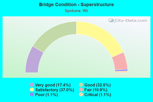
- Bridge Condition - Superstructure
- 17.4%Very good
- 32.6%Good
- 37.0%Satisfactory
- 10.9%Fair
- 1.1%Poor
- 1.1%Critical
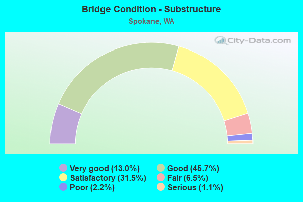
- Bridge Condition - Substructure
- 13.0%Very good
- 45.7%Good
- 31.5%Satisfactory
- 6.5%Fair
- 2.2%Poor
- 1.1%Serious
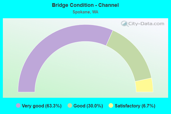
- Bridge Condition - Channel
- 63.3%Very good
- 30.0%Good
- 6.7%Satisfactory
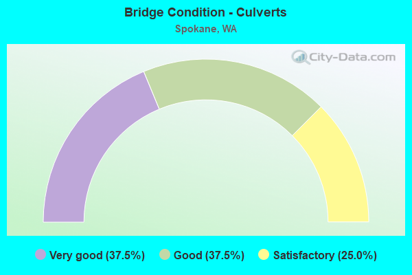
- Bridge Condition - Culverts
- 37.5%Very good
- 37.5%Good
- 25.0%Satisfactory
Find on map >> Show street view
Structure Number: 7094A, Location: 1.6 E JCT US 2 (Lat: 47.646444, Lng: -117.451083), Route carried "under" structure: Interstate 90, Year Built: 1963, Structure Length: 0. m, Average Daily Traffic: 87,874 (year 2019), Truck Traffic: 9%, Features Intersected: I-90, Facility Carried by Structure: US 195
Minimum Vertical Clearance: 5.69m (18.67ft), Kilometerpoint: 449.570, Lanes on structure: 1, Lanes under structure: 7, Material/Design: Prestressed concrete, Design/Construction: Stringer/Multi-beam, Length of Maximum Span: 23.5m (77.1ft)
Find on map >> Show street view
Structure Number: 7094B, Location: 1.6 E JCT US 2 (Lat: 47.646361, Lng: -117.451250), Route carried "under" structure: Interstate 90, Year Built: 1963, Structure Length: 0. m, Average Daily Traffic: 87,874 (year 2019), Truck Traffic: 9%, Features Intersected: I-90, Facility Carried by Structure: US 195
Minimum Vertical Clearance: 5.33m (17.49ft), Kilometerpoint: 449.554, Lanes on structure: 1, Lanes under structure: 7, Material/Design: Prestressed concrete, Design/Construction: Stringer/Multi-beam, Length of Maximum Span: 23.5m (77.1ft)
Find on map >> Show street view
Structure Number: 7317A, Location: 15.2 E LINCOLN CO (Lat: 47.642592, Lng: -117.501125), Route carried "under" structure: County highway 2, Year Built: 1964, Structure Length: 0. m, Average Daily Traffic: 3,024 (year 2012), Truck Traffic: 13%, Features Intersected: W AIRPORT DRIVE
Minimum Vertical Clearance: 4.95m (16.24ft), Kilometerpoint: 0.306, Lanes on structure: 2, Lanes under structure: 2, Material/Design: Prestressed concrete, Design/Construction: Stringer/Multi-beam, Length of Maximum Span: 16.8m (55.1ft)
Find on map >> Show street view
Structure Number: 7317B, Location: 15.2 E LINCOLN CO (Lat: 47.642747, Lng: -117.500925), Route carried "under" structure: County highway 2, Year Built: 1964, Structure Length: 0. m, Average Daily Traffic: 3,024 (year 2012), Truck Traffic: 13%, Features Intersected: W AIRPORT DR
Minimum Vertical Clearance: 5.11m (16.77ft), Kilometerpoint: 0.290, Lanes on structure: 2, Lanes under structure: 2, Material/Design: Prestressed concrete, Design/Construction: Stringer/Multi-beam, Length of Maximum Span: 19.8m (65.0ft)
Find on map >> Show street view
Structure Number: 7630A, Location: 2.3 E JCT SR 904 (Lat: 47.592167, Lng: -117.565472), Route carried "under" structure: Interstate 90, Year Built: 1965, Structure Length: 0. m, Average Daily Traffic: 30,362 (year 2019), Truck Traffic: 16%, Features Intersected: I-90
Minimum Vertical Clearance: 5.23m (17.16ft), Kilometerpoint: 439.045, Lanes on structure: 2, Lanes under structure: 4, Material/Design: Prestressed concrete continuous, Design/Construction: Stringer/Multi-beam, Length of Maximum Span: 22.6m (74.1ft)
Find on map >> Show street view
Structure Number: 7954A, Location: 0.0 E JCT I-90 (Lat: 47.652672, Lng: -117.422242), Route carried "under" structure: US 2, Year Built: 1967, Structure Length: 0. m, Average Daily Traffic: 9,792 (year 2019), Truck Traffic: 3%, Features Intersected: VIADUCT STA 1396 US 2, Facility Carried by Structure: I-90
Minimum Vertical Clearance: 7.54m (24.74ft), Kilometerpoint: 463.620, Lanes on structure: 8, Lanes under structure: 3, Material/Design: Concrete continuous, Design/Construction: Box Beam or Girders - Multiple, Length of Maximum Span: 38.1m (125.0ft)
Find on map >> Show street view
Structure Number: 7954A, Location: 0.0 E JCT I-90 (Lat: 47.652672, Lng: -117.422242), Route carried "under" structure: US 2, Year Built: 1967, Structure Length: 0. m, Average Daily Traffic: 14,464 (year 2019), Truck Traffic: 3%, Features Intersected: VIADUCT STA 1396 US 2, Facility Carried by Structure: I-90
Minimum Vertical Clearance: 5.05m (16.57ft), Kilometerpoint: 461.673, Lanes on structure: 8, Lanes under structure: 3, Material/Design: Concrete continuous, Design/Construction: Box Beam or Girders - Multiple, Length of Maximum Span: 38.1m (125.0ft)
Find on map >> Show street view
Structure Number: 7954C, Location: 1.3 E JCT US 195 (Lat: 47.652356, Lng: -117.412592), Route carried "under" structure: Ramp Interstate 90, Year Built: 1967, Structure Length: 0. m, Average Daily Traffic: 9,611 (year 2019), Truck Traffic: 24%, Features Intersected: DIVISION ST
Minimum Vertical Clearance: 4.93m (16.17ft), Kilometerpoint: 0.306, Lanes on structure: 2, Lanes under structure: 4, Material/Design: Concrete continuous, Design/Construction: Box Beam or Girders - Multiple, Length of Maximum Span: 38.1m (125.0ft)
Find on map >> Show street view
Structure Number: 8322C, Location: 1.2 E JCT US 195 (Lat: 47.652806, Lng: -117.428917), Route carried "under" structure: City street 90, Year Built: 1967, Structure Length: 0. m, Average Daily Traffic: 4,034 (year 2019), Truck Traffic: 5%, Features Intersected: CITY STREET (JEFFERSON), Facility Carried by Structure: W-CEDAR RAMP
Minimum Vertical Clearance: 6.55m (21.49ft), Kilometerpoint: 0.209, Lanes on structure: 2, Lanes under structure: 1, Material/Design: Concrete continuous, Design/Construction: Box Beam or Girders - Multiple, Length of Maximum Span: 40.2m (131.9ft)
Find on map >> Show street view
Structure Number: 8540A, Location: 1.4 E JCT US 2 (Lat: 47.653922, Lng: -117.382867), Route carried "under" structure: Interstate 90, Year Built: 1969, Structure Length: 0. m, Average Daily Traffic: 124,793 (year 2019), Truck Traffic: 7%, Features Intersected: I-90, Facility Carried by Structure: PEDS - MAGNOLIA
Minimum Vertical Clearance: 6.58m (21.59ft), Kilometerpoint: 454.913, Lanes under structure: 8, Material/Design: Prestressed concrete, Design/Construction: Tee Beam, Length of Maximum Span: 44.5m (146.0ft)
Find on map >> Show street view
Structure Number: 8611A, Location: 0.4 E JCT US 2 (Lat: 47.651944, Lng: -117.403139), Route carried "under" structure: Interstate 90, Year Built: 1970, Structure Length: 0. m, Average Daily Traffic: 115,691 (year 2019), Truck Traffic: 7%, Features Intersected: I-90, Facility Carried by Structure: SHERMAN ST
Minimum Vertical Clearance: 6.91m (22.67ft), Kilometerpoint: 453.352, Lanes on structure: 3, Lanes under structure: 8, Material/Design: Concrete continuous, Design/Construction: Box Beam or Girders - Multiple, Length of Maximum Span: 22.6m (74.1ft)
Find on map >> Show street view
Structure Number: 8611B, Location: 0.7 E JCT US 2 (Lat: 47.651889, Lng: -117.395250), Route carried "under" structure: Interstate 90, Year Built: 1970, Structure Length: 0. m, Average Daily Traffic: 104,436 (year 2019), Truck Traffic: 7%, Features Intersected: I-90, Facility Carried by Structure: ARTHUR ST
Minimum Vertical Clearance: 5.38m (17.65ft), Kilometerpoint: 453.948, Lanes on structure: 2, Lanes under structure: 10, Material/Design: Concrete continuous, Design/Construction: Box Beam or Girders - Multiple, Length of Maximum Span: 34.1m (111.9ft)
Find on map >> Show street view
Structure Number: 8664A, Location: 27.2 N WHITMAN CO (Lat: 47.622861, Lng: -117.437167), Route carried "under" structure: US 195, Year Built: 1970, Structure Length: 0. m, Average Daily Traffic: 7,805 (year 2019), Truck Traffic: 8%, Features Intersected: STATE ROUTE 195, Facility Carried by Structure: NP RY
Minimum Vertical Clearance: 6.30m (20.67ft), Kilometerpoint: 151.536, Lanes under structure: 5, Material/Design: Steel, Design/Construction: Girder and Floorbeam System, Length of Maximum Span: 38.1m (125.0ft)
Find on map >> Show street view
Structure Number: 8664B, Location: 27.2 N WHITMAN CO (Lat: 47.622917, Lng: -117.437278), Route carried "under" structure: US 195, Year Built: 1970, Structure Length: 0. m, Average Daily Traffic: 15,610 (year 2019), Truck Traffic: 8%, Features Intersected: STATE ROUTE 195, Facility Carried by Structure: NP RY
Minimum Vertical Clearance: 6.40m (21.00ft), Kilometerpoint: 151.536, Lanes under structure: 5, Material/Design: Steel, Design/Construction: Girder and Floorbeam System, Length of Maximum Span: 28.3m (92.8ft)
Find on map >> Show street view
Structure Number: 8740A, Location: 0.6 E JCT US 195 (Lat: 47.649694, Lng: -117.443889), Route carried "under" structure: Interstate 90, Year Built: 1970, Structure Length: 0. m, Average Daily Traffic: 100,158 (year 2019), Truck Traffic: 9%, Features Intersected: I-90, Facility Carried by Structure: NP RY
Minimum Vertical Clearance: 5.26m (17.26ft), Kilometerpoint: 450.230, Lanes under structure: 6, Material/Design: Steel, Design/Construction: Stringer/Multi-beam, Length of Maximum Span: 26.8m (87.9ft)
Find on map >> Show street view
Structure Number: 8774A, Location: JCT I-90 (Lat: 47.652278, Lng: -117.394333), Route carried "under" structure: State highway 290, Year Built: 1970, Structure Length: 0. m, Average Daily Traffic: 8,017 (year 2019), Truck Traffic: 4%, Features Intersected: 3RD AV & W-E RAMP, Facility Carried by Structure: I-90
Minimum Vertical Clearance: 5.31m (17.42ft), Kilometerpoint: 0.113, Lanes on structure: 6, Lanes under structure: 2, Material/Design: Concrete continuous, Design/Construction: Box Beam or Girders - Multiple, Length of Maximum Span: 37.8m (124.0ft)
Find on map >> Show street view
Structure Number: 8774C, Location: 0.1 E JCT I-90 (Lat: 47.653361, Lng: -117.392611), Route carried "under" structure: Ramp State highway 290, Year Built: 1971, Structure Length: 0. m, Average Daily Traffic: 8,017 (year 2019), Truck Traffic: 4%, Features Intersected: 3RD AVE & W-E RAMP
Minimum Vertical Clearance: 5.38m (17.65ft), Kilometerpoint: 0.177, Lanes on structure: 2, Lanes under structure: 3, Material/Design: Concrete continuous, Design/Construction: Box Beam or Girders - Multiple, Length of Maximum Span: 30.8m (101.0ft)
Find on map >> Show street view
Structure Number: 8774D, Location: 0.8 E JCT US 2 (Lat: 47.652000, Lng: -117.394056), Route carried "under" structure: Interstate 90, Year Built: 1970, Structure Length: 0. m, Average Daily Traffic: 104,436 (year 2019), Truck Traffic: 7%, Features Intersected: 3RD AVE & I-90
Minimum Vertical Clearance: 5.51m (18.08ft), Kilometerpoint: 454.237, Lanes on structure: 2, Lanes under structure: 6, Material/Design: Concrete continuous, Design/Construction: Box Beam or Girders - Multiple, Length of Maximum Span: 39.6m (129.9ft)
Find on map >> Show street view
Structure Number: 9150A, Location: 15.3 E LINCOLN CO (Lat: 47.641694, Lng: -117.498833), Route carried "under" structure: Ramp US 2, Year Built: 1972, Structure Length: 0. m, Average Daily Traffic: 4,235 (year 2012), Truck Traffic: 5%, Features Intersected: W-W RAMP
Minimum Vertical Clearance: 5.00m (16.40ft), Kilometerpoint: 0.805, Lanes on structure: 2, Lanes under structure: 2, Material/Design: Prestressed concrete, Design/Construction: Box Beam or Girders - Multiple, Length of Maximum Span: 44.5m (146.0ft)
Find on map >> Show street view
Structure Number: 9150B, Location: 15.3 E LINCOLN CO (Lat: 47.641556, Lng: -117.498056), Route carried "under" structure: Ramp US 2, Year Built: 1972, Structure Length: 0. m, Average Daily Traffic: 4,235 (year 2012), Truck Traffic: 5%, Features Intersected: W-W RAMP
Minimum Vertical Clearance: 4.57m (14.99ft), Kilometerpoint: 0.772, Lanes on structure: 2, Lanes under structure: 2, Material/Design: Prestressed concrete, Design/Construction: Box Beam or Girders - Multiple, Length of Maximum Span: 44.5m (146.0ft)
Find on map >> Show street view
Structure Number: 9150C, Location: 15.3 E LINCOLN CO (Lat: 47.641286, Lng: -117.502544), Route carried "under" structure: Ramp County highway 2, Year Built: 1972, Structure Length: 0. m, Average Daily Traffic: 1,512 (year 2012), Truck Traffic: 13%, Features Intersected: SUNSET HWY, Facility Carried by Structure: W-W & E-E RAMPS
Minimum Vertical Clearance: 5.03m (16.50ft), Kilometerpoint: 0.467, Lanes on structure: 4, Lanes under structure: 1, Material/Design: Prestressed concrete, Design/Construction: Stringer/Multi-beam, Length of Maximum Span: 22.9m (75.1ft)
Find on map >> Show street view
Structure Number: 12327A, Location: 0.4 E JCT I-90 (Lat: 47.657056, Lng: -117.394806), Route carried "under" structure: City street , Year Built: 1984, Structure Length: 0. m, Average Daily Traffic: 10,235 (year 2015), Truck Traffic: 8%, Features Intersected: RR,SPOKANE RIVER,CITY ST, Facility Carried by Structure: SR 290
Minimum Vertical Clearance: 6.65m (21.82ft), Kilometerpoint: 2.849, Lanes on structure: 4, Lanes under structure: 3, Material/Design: Prestressed concrete continuous, Design/Construction: Box Beam or Girders - Multiple, Length of Maximum Span: 76.5m (251.0ft)
Find on map >> Show street view
Structure Number: 18378A, Location: 26.9 N WHITMAN CO (Lat: 47.619417, Lng: -117.433333), Route carried "under" structure: US 195, Year Built: 2014, Structure Length: 0. m, Average Daily Traffic: 15,610 (year 2019), Truck Traffic: 8%, Features Intersected: SR 195, Facility Carried by Structure: CHENEY SPOKANE RD
Minimum Vertical Clearance: 5.92m (19.42ft), Kilometerpoint: 151.085, Lanes on structure: 2, Lanes under structure: 4, Material/Design: Prestressed concrete continuous, Design/Construction: Stringer/Multi-beam, Length of Maximum Span: 33.8m (110.9ft)
Find on map >> Show street view
Structure Number: 19425A, Location: 2.3 E JCT SR 904 (Lat: 47.592097, Lng: -117.565556), Route carried "under" structure: Interstate 90, Year Built: 2020, Structure Length: 0. m, Average Daily Traffic: 30,362 (year 2019), Truck Traffic: 23%, Features Intersected: I-90
Minimum Vertical Clearance: 5.26m (17.26ft), Kilometerpoint: 439.029, Lanes on structure: 2, Lanes under structure: 4, Material/Design: Prestressed concrete continuous, Design/Construction: Stringer/Multi-beam, Length of Maximum Span: 33.5m (109.9ft)
Find on map >> Show street view
Structure Number: 8079, Location: 0.6 N TRAILS ROAD (Lat: 47.679997, Lng: -117.522211), Route carried "under" structure: County highway 4837, Year Built: 1972, Structure Length: 0. m, Average Daily Traffic: 9,266 (year 2020), Truck Traffic: 12%, Features Intersected: TRAILS ROAD, Facility Carried by Structure: BNSF RR
Minimum Vertical Clearance: 5.03m (16.50ft), Kilometerpoint: 0.001, Lanes under structure: 2, Material/Design: Steel, Design/Construction: Stringer/Multi-beam, Length of Maximum Span: 29.9m (98.1ft)
Find on map >> Show street view
Structure Number: 84929, Location: 00.13 SOUTH I-90 (Lat: 47.644208, Lng: -117.452711), Route carried "under" structure: City street 2822, Year Built: 1972, Structure Length: 0. m, Average Daily Traffic: 539 (year 2019), Truck Traffic: 1%, Features Intersected: 13TH AVE, Facility Carried by Structure: BNSFRR
Minimum Vertical Clearance: 4.65m (15.26ft), Kilometerpoint: 0.001, Lanes under structure: 2, Material/Design: Steel, Design/Construction: Stringer/Multi-beam, Length of Maximum Span: 22.6m (74.1ft)
Find on map >> Show street view
Structure Number: 84935, Location: 0.04 W LINDEKE ST (Lat: 47.642850, Lng: -117.452294), Route carried "under" structure: City street 2660, Year Built: 1913, Structure Length: 0. m, Average Daily Traffic: 1,724 (year 2019), Features Intersected: 14TH AVE, Facility Carried by Structure: BNSFRR
Minimum Vertical Clearance: 3.53m (11.58ft), Kilometerpoint: 0.001, Lanes under structure: 2, Material/Design: Steel, Design/Construction: Stringer/Multi-beam, Length of Maximum Span: 10.1m (33.1ft)
Find on map >> Show street view
Structure Number: 84936, Location: 142 Ft W of JCT w/ HWY 19 (Lat: 47.641008, Lng: -117.449303), Route carried "under" structure: City street 2661, Year Built: 1912, Structure Length: 0. m, Average Daily Traffic: 3,699 (year 2019), Truck Traffic: 1%, Features Intersected: 16TH AVE, Facility Carried by Structure: PED TRAIL
Minimum Vertical Clearance: 3.45m (11.32ft), Kilometerpoint: 0.001, Lanes under structure: 2, Material/Design: Steel, Design/Construction: Girder and Floorbeam System, Length of Maximum Span: 12.5m (41.0ft)
Find on map >> Show street view
Structure Number: 84938, Location: 00.04 EAST I-90 (Lat: 47.649411, Lng: -117.443992), Route carried "under" structure: ServiceCity street 2828, Year Built: 1935, Structure Length: 0. m, Average Daily Traffic: 754 (year 2019), Truck Traffic: 1%, Features Intersected: 7TH AVE, Facility Carried by Structure: BNSFRR
Minimum Vertical Clearance: 16.76m (54.99ft), Kilometerpoint: 0.001, Lanes under structure: 2, Material/Design: Steel, Design/Construction: Stringer/Multi-beam, Length of Maximum Span: 20.7m (67.9ft)
Find on map >> Show street view
Structure Number: 8495, Location: 00.05 NORTH 2ND AVE (Lat: 47.655583, Lng: -117.423483), Route carried "under" structure: City street 3730, Year Built: 1915, Structure Length: 0. m, Average Daily Traffic: 2,700 (year 2017), Truck Traffic: 1%, Features Intersected: POST ST, Facility Carried by Structure: BNSFRR
Minimum Vertical Clearance: 3.66m (12.01ft), Kilometerpoint: 16.093, Lanes under structure: 2, Material/Design: Concrete, Design/Construction: Box Beam or Girders - Single/Spread, Length of Maximum Span: 8.2m (26.9ft)
Find on map >> Show street view
Structure Number: 84953, Location: 00.13 S SR290 (Lat: 47.659333, Lng: -117.387211), Route carried "under" structure: City street 5110, Year Built: 1914, Structure Length: 0. m, Average Daily Traffic: 3,878 (year 2019), Features Intersected: HELENA ST, Facility Carried by Structure: BNSFRR
Minimum Vertical Clearance: 3.66m (12.01ft), Kilometerpoint: 0.001, Lanes under structure: 2, Material/Design: Concrete, Design/Construction: Slab, Length of Maximum Span: 6.4m (21.0ft)
Find on map >> Show street view
Structure Number: 84955, Location: 00.09 SOUTH SR290 (Lat: 47.660528, Lng: -117.381211), Route carried "under" structure: City street 5135, Year Built: 1916, Structure Length: 0. m, Average Daily Traffic: 7,002 (year 2019), Truck Traffic: 1%, Features Intersected: NAPA ST, Facility Carried by Structure: BNSFRR
Minimum Vertical Clearance: 3.78m (12.40ft), Kilometerpoint: 0.001, Lanes under structure: 2, Material/Design: Concrete, Design/Construction: Slab, Length of Maximum Span: 6.4m (21.0ft)
Find on map >> Show street view
Structure Number: 84958, Location: AT PSH 2 (Lat: 47.647611, Lng: -117.456311), Route carried "under" structure: City street 2880, Year Built: 1972, Structure Length: 0. m, Average Daily Traffic: 13,035 (year 2019), Truck Traffic: 4%, Features Intersected: SUNSET BLVD, Facility Carried by Structure: BNSFRR
Minimum Vertical Clearance: 6.32m (20.73ft), Kilometerpoint: 24.140, Lanes under structure: 4, Material/Design: Steel, Design/Construction: Box Beam or Girders - Single/Spread, Length of Maximum Span: 22.9m (75.1ft)
Find on map >> Show street view
Structure Number: 84962, Location: 00.04 N 2ND AVE (Lat: 47.655183, Lng: -117.433992), Route carried "under" structure: City street 3590, Year Built: 1915, Structure Length: 0. m, Average Daily Traffic: 24,131 (year 2019), Truck Traffic: 2%, Features Intersected: WALNUT ST, Facility Carried by Structure: BNSFRR
Minimum Vertical Clearance: 4.22m (13.85ft), Kilometerpoint: 32.187, Lanes under structure: 3, Material/Design: Concrete, Design/Construction: Slab, Length of Maximum Span: 8.2m (26.9ft)
Find on map >> Show street view
Structure Number: 84965, Location: 00.05 NORTH 2ND AVE (Lat: 47.655561, Lng: -117.425014), Route carried "under" structure: City street 3710, Year Built: 1915, Structure Length: 0. m, Average Daily Traffic: 10,900 (year 2017), Truck Traffic: 1%, Features Intersected: LINCOLN ST, Facility Carried by Structure: BNSFRR
Minimum Vertical Clearance: 4.34m (14.24ft), Kilometerpoint: 32.187, Lanes under structure: 3, Material/Design: Concrete, Design/Construction: Box Beam or Girders - Single/Spread, Length of Maximum Span: 8.2m (26.9ft)
Find on map >> Show street view
Structure Number: 84966, Location: 00.06 NORTH 2ND AVE (Lat: 47.655592, Lng: -117.421044), Route carried "under" structure: City street 3750, Year Built: 1915, Structure Length: 0. m, Average Daily Traffic: 3,900 (year 2017), Truck Traffic: 1%, Features Intersected: HOWARD ST, Facility Carried by Structure: BNSFRR
Minimum Vertical Clearance: 4.27m (14.01ft), Kilometerpoint: 32.187, Lanes under structure: 2, Material/Design: Steel, Design/Construction: Box Beam or Girders - Multiple, Length of Maximum Span: 8.2m (26.9ft)
Find on map >> Show street view
Structure Number: 84967, Location: 00.05 NORTH 2ND AVE (Lat: 47.655603, Lng: -117.419539), Route carried "under" structure: City street 3930, Year Built: 1916, Structure Length: 0. m, Average Daily Traffic: 10,900 (year 2017), Features Intersected: STEVENS ST, Facility Carried by Structure: BNSFRR
Minimum Vertical Clearance: 3.61m (11.84ft), Kilometerpoint: 32.187, Lanes under structure: 3, Material/Design: Concrete, Design/Construction: Box Beam or Girders - Single/Spread, Length of Maximum Span: 8.2m (26.9ft)
Find on map >> Show street view
Structure Number: 84974, Location: AT 2ND AVENUE (Lat: 47.654483, Lng: -117.435658), Route carried "under" structure: City street 3590, Year Built: 1916, Structure Length: 0. m, Average Daily Traffic: 21,869 (year 2019), Truck Traffic: 2%, Features Intersected: MAPLE ST, 2ND AVE, Facility Carried by Structure: BNSFRR
Minimum Vertical Clearance: 4.42m (14.50ft), Kilometerpoint: 48.280, Lanes under structure: 4, Material/Design: Steel, Design/Construction: Girder and Floorbeam System, Length of Maximum Span: 30.2m (99.1ft)
Find on map >> Show street view
Structure Number: 84975, Location: 00.05 NORTH 2ND AVE (Lat: 47.655556, Lng: -117.428047), Route carried "under" structure: City street 3710, Year Built: 1915, Structure Length: 0. m, Average Daily Traffic: 14,200 (year 2017), Truck Traffic: 2%, Features Intersected: MONROE ST, Facility Carried by Structure: BNSFRR
Minimum Vertical Clearance: 4.19m (13.75ft), Kilometerpoint: 48.280, Lanes under structure: 3, Material/Design: Concrete, Design/Construction: Slab, Length of Maximum Span: 8.2m (26.9ft)
Find on map >> Show street view
Structure Number: 84976, Location: 00.05 NORTH 2ND AVE (Lat: 47.655586, Lng: -117.422058), Route carried "under" structure: City street 3731, Year Built: 1915, Structure Length: 0. m, Average Daily Traffic: 1,100 (year 2017), Features Intersected: WALL ST, Facility Carried by Structure: BNSFRR
Minimum Vertical Clearance: 3.56m (11.68ft), Kilometerpoint: 48.280, Lanes under structure: 2, Material/Design: Concrete, Design/Construction: Slab, Length of Maximum Span: 7.0m (23.0ft)
Find on map >> Show street view
Structure Number: 84977, Location: 00.08 NORTH 2ND AVE (Lat: 47.655750, Lng: -117.417992), Route carried "under" structure: City street 3930, Year Built: 1915, Structure Length: 0. m, Average Daily Traffic: 12,500 (year 2017), Truck Traffic: 1%, Features Intersected: WASHINGTON ST, Facility Carried by Structure: BNSFRR
Minimum Vertical Clearance: 6.71m (22.01ft), Kilometerpoint: 48.280, Lanes under structure: 3, Material/Design: Concrete, Design/Construction: Arch - Deck, Length of Maximum Span: 20.1m (65.9ft)
Find on map >> Show street view
Structure Number: 84982, Location: 00.01 SOUTH SR 290 (Lat: 47.661753, Lng: -117.381208), Route carried "under" structure: City street 5135, Year Built: 1916, Structure Length: 0. m, Average Daily Traffic: 7,002 (year 2019), Truck Traffic: 1%, Features Intersected: NAPA ST, Facility Carried by Structure: UPRR
Minimum Vertical Clearance: 4.50m (14.76ft), Kilometerpoint: 0.001, Lanes under structure: 2, Material/Design: Steel, Design/Construction: Girder and Floorbeam System, Length of Maximum Span: 13.4m (44.0ft)
Find on map >> Show street view
Structure Number: 84983, Location: 00.17 NORTH I-90 (Lat: 47.653572, Lng: -117.437528), Route carried "under" structure: City street 2880, Year Built: 1916, Structure Length: 0. m, Average Daily Traffic: 8,403 (year 2019), Truck Traffic: 4%, Features Intersected: 3RD AVE, Facility Carried by Structure: BNSFRR
Minimum Vertical Clearance: 4.34m (14.24ft), Kilometerpoint: 80.467, Lanes under structure: 3, Material/Design: Steel, Design/Construction: Girder and Floorbeam System, Length of Maximum Span: 14.0m (45.9ft)
Find on map >> Show street view
Structure Number: 84985, Location: 01.03 N SR 290 (Lat: 47.682983, Lng: -117.364331), Route carried "under" structure: City street 5330, Year Built: 1941, Structure Length: 0. m, Average Daily Traffic: 42,014 (year 2019), Truck Traffic: 12%, Features Intersected: GREENE ST, Facility Carried by Structure: BNSFRR
Minimum Vertical Clearance: 4.72m (15.49ft), Kilometerpoint: 80.467, Lanes under structure: 4, Material/Design: Steel, Design/Construction: Stringer/Multi-beam, Length of Maximum Span: 9.8m (32.2ft)
Find on map >> Show street view
Structure Number: 85146, Location: 1.75 N OF I-90 (Lat: 47.678336, Lng: -117.363728), Route carried "under" structure: City street 3902, Year Built: 1955, Structure Length: 0. m, Average Daily Traffic: 7,000 (year 2019), Truck Traffic: 11%, Features Intersected: SPOKANE RIV,UPRIVER DR, Facility Carried by Structure: GREENE STREET
Minimum Vertical Clearance: 5.36m (17.59ft), Kilometerpoint: 0.001, Lanes on structure: 4, Lanes under structure: 2, Material/Design: Concrete, Design/Construction: Arch - Deck, Length of Maximum Span: 40.5m (132.9ft)
Find on map >> Show street view
Structure Number: 85146, Location: 1.65 N OF I-90 (Lat: 47.678336, Lng: -117.363728), Route carried "under" structure: City street 3989, Year Built: 1955, Structure Length: 0. m, Average Daily Traffic: 1,800 (year 2019), Truck Traffic: 4%, Features Intersected: SPOKANE RIV,UPRIVER DR, Facility Carried by Structure: GREENE STREET
Minimum Vertical Clearance: 5.44m (17.85ft), Kilometerpoint: 3.991, Lanes on structure: 4, Lanes under structure: 2, Material/Design: Concrete, Design/Construction: Arch - Deck, Length of Maximum Span: 40.5m (132.9ft)
Find on map >> Show street view
Structure Number: 85188, Location: 1.2 W OF SR 395 (Lat: 47.661769, Lng: -117.435428), Route carried "under" structure: City street 838, Year Built: 1958, Structure Length: 0. m, Average Daily Traffic: 40,612 (year 2017), Truck Traffic: 2%, Features Intersected: MAPLE STREET, Facility Carried by Structure: OHIO AVENUE
Minimum Vertical Clearance: 4.55m (14.93ft), Kilometerpoint: 0.001, Lanes under structure: 4, Material/Design: Concrete continuous, Design/Construction: Slab, Length of Maximum Span: 10.4m (34.1ft)
Find on map >> Show street view
Structure Number: 86152, Location: Wellesley and Addison (Lat: 47.700706, Lng: -117.406867), Route carried "under" structure: City street 882, Year Built: 1992, Structure Length: 0. m, Average Daily Traffic: 11,200 (year 2017), Truck Traffic: 1%, Features Intersected: WELLESLEY AVENUE, Facility Carried by Structure: GARAGE ENTRANCE
Minimum Vertical Clearance: 30+ m (98+ ft), Kilometerpoint: 0.161, Lanes on structure: 1, Lanes under structure: 3, Material/Design: Concrete, Design/Construction: Box Beam or Girders - Single/Spread, Length of Maximum Span: 19.2m (63.0ft)