Bridge Statistics for Sheridan, Wyoming (WY)
Condition, Traffic, Stress, Structural Evaluation, Project Costs
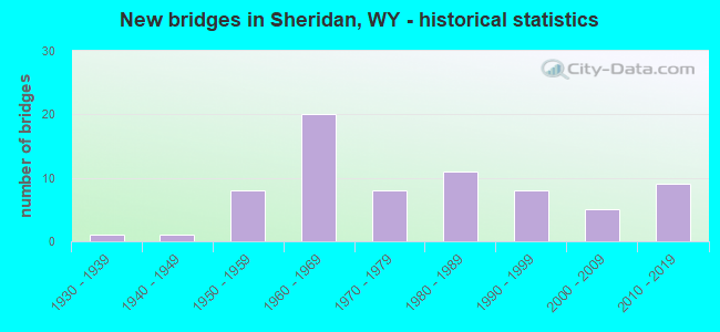
- New bridges - historical statistics
- 11930-1939
- 11940-1949
- 81950-1959
- 201960-1969
- 81970-1979
- 111980-1989
- 81990-1999
- 52000-2009
- 92010-2019
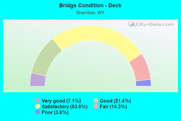
- Bridge Condition - Deck
- 7.1%Very good
- 21.4%Good
- 53.6%Satisfactory
- 14.3%Fair
- 3.6%Poor
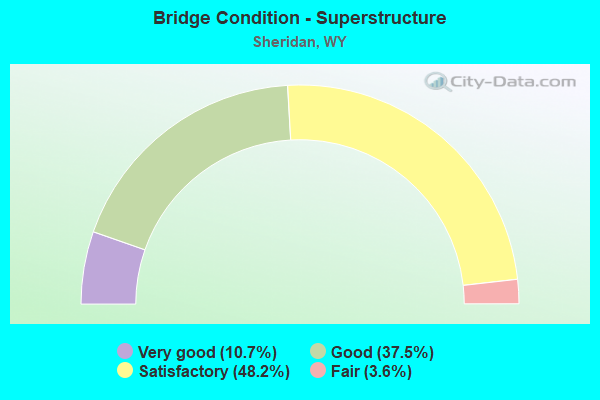
- Bridge Condition - Superstructure
- 10.7%Very good
- 37.5%Good
- 48.2%Satisfactory
- 3.6%Fair
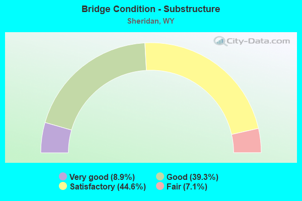
- Bridge Condition - Substructure
- 8.9%Very good
- 39.3%Good
- 44.6%Satisfactory
- 7.1%Fair
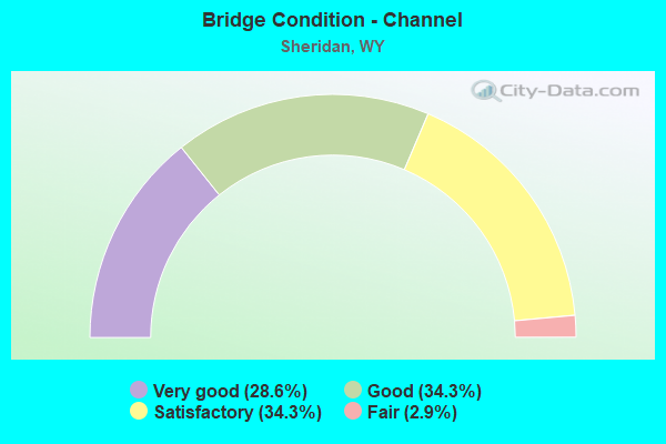
- Bridge Condition - Channel
- 28.6%Very good
- 34.3%Good
- 34.3%Satisfactory
- 2.9%Fair
Find on map >> Show street view
Structure Number: FNE, Location: 7 Mi S.W Of Sheridan (Lat: 44.760097, Lng: -107.074369), Route carried "on" structure: County highway 87, Year Built: 1988, Status: Open, Structure Length: 1.71m (5.61ft), Average Daily Traffic: 250 (year 2021), Truck Traffic: 6%, Average Future Daily Traffic: 350 (year 2041), Design Load: HS 20, Features Intersected: Big Goose Creek
Minimum Vertical Clearance: 30+ m (98+ ft), Kilometerpoint: 0.388, Lanes on structure: 2, Owner: County Highway Agency, Approaching Roadway Width: 8.5m (27.9ft), Skew: 3 degrees, Material/Design: Steel, Design/Construction: Stringer/Multi-beam, Number Of Spans In Main Unit: 1, Length of Maximum Span: 15.5m (50.9ft), Curb-To-Curb Width: 8.5m (27.9ft), Out-to-Out Width: 9.3m (30.5ft)
Condition: Deck: Satisfactory, Superstructure: Good, Substructure: Fair, Channel: Good, Operating Rating: 47.2 metric tons, Method Used To Determine Operating Rating: Allowable Stress (AS), Inventory Rating: 37.2 metric tons, Method Used To Determine Inventory Rating: Allowable Stress (AS), Structural Evaluation: Somewhat better than minimum adequacy, Deck Geometry: Equal to present minimum criteria, Waterway Adequacy: Equal to present desirable criteria, Approach Roadway Alignment: Equal to present desirable criteria, Length Of Structure Improvement: 1.71m (5.61ft), Designated Inspection Frequency: Every 24 months, Inspection Date: April 2020, Bridge Improvement Cost: $12,000, Roadway Improvement Cost: $30,000, Total Project Cost: $43,000 ( Estimate for 2014), Deck Structure Type: Concrete Cast-file-Place
Find on map >> Show street view
Structure Number: FNF, Location: 4 Mi N.E. Of Sheridan (Lat: 44.795306, Lng: -106.927336), Route carried "on" structure: City street 139, Year Built: 1988, Status: Open, Structure Length: 3.69m (12.11ft), Average Daily Traffic: 791 (year 2021), Truck Traffic: 10%, Average Future Daily Traffic: 1,107 (year 2041), Design Load: HS 20, Features Intersected: BNSF Railway
Minimum Vertical Clearance: 30+ m (98+ ft), Kilometerpoint: 1.234, Lanes on structure: 2, Owner: Town or Township Highway Agency, Approaching Roadway Width: 9.8m (32.2ft), Material/Design: Steel continuous, Design/Construction: Stringer/Multi-beam, Number Of Spans In Main Unit: 3, Length of Maximum Span: 14.0m (45.9ft), Curb-To-Curb Width: 8.5m (27.9ft), Out-to-Out Width: 9.4m (30.8ft)
Condition: Deck: Fair, Superstructure: Good, Substructure: Good, Operating Rating: 40.8 metric tons, Method Used To Determine Operating Rating: Allowable Stress (AS), Inventory Rating: 30.8 metric tons, Method Used To Determine Inventory Rating: Allowable Stress (AS), Structural Evaluation: Better than present minimum criteria, Deck Geometry: Somewhat better than minimum adequacy, Underclear: Somewhat better than minimum adequacy, Approach Roadway Alignment: Equal to present desirable criteria, Length Of Structure Improvement: 8.26m (27.10ft), Designated Inspection Frequency: Every 24 months, Inspection Date: April 2021, Bridge Improvement Cost: $24,000, Roadway Improvement Cost: $30,000, Total Project Cost: $57,000, Deck Structure Type: Concrete Cast-file-Place
Find on map >> Show street view
Structure Number: FNK, Location: City Of Sheridan (Lat: 44.798942, Lng: -106.948425), Route carried "on" structure: City street 4411, Year Built: 1990, Status: Open, Structure Length: 2.84m (9.32ft), Average Daily Traffic: 6,061 (year 2021), Truck Traffic: 14%, Average Future Daily Traffic: 8,485 (year 2041), Design Load: HS 20, Features Intersected: Little Goose Creek, Facility Carried by Structure: S. Sheridan Avenue
Minimum Vertical Clearance: 30+ m (98+ ft), Kilometerpoint: 161.128, Lanes on structure: 2, Owner: Town or Township Highway Agency, Approaching Roadway Width: 15.8m (51.8ft), Skew: 1 degrees, Material/Design: Concrete continuous, Design/Construction: Slab, Number Of Spans In Main Unit: 3, Length of Maximum Span: 11.0m (36.1ft), Curb or Sidewalk Widths: Left: 1.5m (4.9ft), Right: 1.5m (4.9ft), Curb-To-Curb Width: 15.8m (51.8ft), Out-to-Out Width: 20.3m (66.6ft)
Condition: Deck: Satisfactory, Superstructure: Satisfactory, Substructure: Good, Channel: Good, Operating Rating: 59.9 metric tons, Method Used To Determine Operating Rating: Allowable Stress (AS), Inventory Rating: 35.4 metric tons, Method Used To Determine Inventory Rating: Allowable Stress (AS), Structural Evaluation: Equal to present minimum criteria, Deck Geometry: Superior to present desirable criteria, Waterway Adequacy: Equal to present desirable criteria, Approach Roadway Alignment: Equal to present desirable criteria, Length Of Structure Improvement: 2.83m (9.28ft), Designated Inspection Frequency: Every 24 months, Inspection Date: April 2021, Bridge Improvement Cost: $10,000, Roadway Improvement Cost: $1,000, Total Project Cost: $12,000, Deck Structure Type: Concrete Cast-file-Place, Wearing Surface/Protective System: Wearing Surface: Epoxy Overlay
Find on map >> Show street view
Structure Number: JNN, Location: Brundage Lane-Sheridan (Lat: 44.773694, Lng: -106.950711), Route carried "on" structure: State highway 334, Year Built: 1993, Status: Open, Structure Length: 5.49m (18.01ft), Average Daily Traffic: 7,519 (year 2021), Truck Traffic: 9%, Average Future Daily Traffic: 10,527 (year 2041), Design Load: HS 20, Features Intersected: Little Goose Creek
Minimum Vertical Clearance: 30+ m (98+ ft), Kilometerpoint: 0.552, Lanes on structure: 3, Owner: State Highway Agency, Approaching Roadway Width: 15.8m (51.8ft), Material/Design: Steel continuous, Design/Construction: Stringer/Multi-beam, Number Of Spans In Main Unit: 3, Length of Maximum Span: 21.3m (69.9ft), Curb or Sidewalk Widths: Left: 1.2m (3.9ft), Right: 1.2m (3.9ft), Curb-To-Curb Width: 15.8m (51.8ft), Out-to-Out Width: 19.5m (64.0ft)
Condition: Deck: Fair, Superstructure: Good, Substructure: Good, Channel: Good, Operating Rating: 59.9 metric tons, Method Used To Determine Operating Rating: Load Factor (LF), Inventory Rating: 35.4 metric tons, Method Used To Determine Inventory Rating: Load Factor (LF), Structural Evaluation: Better than present minimum criteria, Deck Geometry: Better than present minimum criteria, Waterway Adequacy: Equal to present minimum criteria, Approach Roadway Alignment: Equal to present desirable criteria, Designated Inspection Frequency: Every 24 months, Inspection Date: June 2020, Deck Structure Type: Concrete Cast-file-Place
Find on map >> Show street view
Structure Number: KIS, Location: City Of Sheridan (Lat: 44.794222, Lng: -106.947019), Route carried "on" structure: City street 400-2, Year Built: 1996, Status: Open, Structure Length: 1.89m (6.20ft), Average Daily Traffic: 9,762 (year 2021), Truck Traffic: 4%, Average Future Daily Traffic: 13,667 (year 2041), Design Load: HS 20, Features Intersected: Little Goose Creek, Facility Carried by Structure: Park Street
Minimum Vertical Clearance: 30+ m (98+ ft), Kilometerpoint: 161.638, Lanes on structure: 2, Owner: Town or Township Highway Agency, Approaching Roadway Width: 12.2m (40.0ft), Material/Design: Steel, Design/Construction: Stringer/Multi-beam, Number Of Spans In Main Unit: 1, Length of Maximum Span: 18.3m (60.0ft), Curb or Sidewalk Widths: Left: 1.2m (3.9ft), Right: 1.2m (3.9ft), Curb-To-Curb Width: 7.4m (24.3ft), Out-to-Out Width: 11.0m (36.1ft)
Condition: Deck: Satisfactory, Superstructure: Satisfactory, Substructure: Good, Channel: Good, Operating Rating: 67.5 metric tons, Method Used To Determine Operating Rating: Load Factor (LF), Inventory Rating: 40.5 metric tons, Method Used To Determine Inventory Rating: Load Factor (LF), Structural Evaluation: Equal to present minimum criteria, Deck Geometry: High priority of replacement, Waterway Adequacy: Equal to present desirable criteria, Approach Roadway Alignment: Equal to present desirable criteria, Length Of Structure Improvement: 0.46m (1.51ft), Designated Inspection Frequency: Every 24 months, Inspection Date: April 2020, Bridge Improvement Cost: $2,000, Roadway Improvement Cost: $1,000, Total Project Cost: $4,000 ( Estimate for 2014), Deck Structure Type: Concrete Cast-file-Place, Wearing Surface/Protective System: Wearing Surface: Bituminous
Find on map >> Show street view
Structure Number: KKY, Location: Sheridan North South (Lat: 44.804967, Lng: -106.936919), Route carried "on" structure: Interstate 90, Year Built: 1995, Status: Open, Structure Length: 4.63m (15.19ft), Average Daily Traffic: 3,288 (year 2021), Truck Traffic: 23%, Average Future Daily Traffic: 4,603 (year 2041), Design Load: HS 25 or greater, Features Intersected: 5th Street / WYO 336
Minimum Vertical Clearance: 30+ m (98+ ft), Kilometerpoint: 39.765, Lanes on structure: 2, Lanes under structure: 3, Base Highway Network: Yes (Inventory Route: ML9, Subroute: 1), Owner: State Highway Agency, Approaching Roadway Width: 12.8m (42.0ft), Material/Design: Steel continuous, Design/Construction: Stringer/Multi-beam, Number Of Spans In Main Unit: 3, Length of Maximum Span: 28.7m (94.2ft), Curb-To-Curb Width: 12.8m (42.0ft), Out-to-Out Width: 13.6m (44.6ft)
Condition: Deck: Satisfactory, Superstructure: Good, Substructure: Very good, Operating Rating: 69.9 metric tons, Method Used To Determine Operating Rating: Load Factor (LF), Inventory Rating: 41.7 metric tons, Method Used To Determine Inventory Rating: Load Factor (LF), Structural Evaluation: Better than present minimum criteria, Deck Geometry: Equal to present desirable criteria, Underclear: Equal to present minimum criteria, Approach Roadway Alignment: Equal to present desirable criteria, Designated Inspection Frequency: Every 24 months, Inspection Date: August 2021, Deck Structure Type: Concrete Cast-file-Place
Find on map >> Show street view
Structure Number: KKZ, Location: Sheridan North South (Lat: 44.804956, Lng: -106.936661), Route carried "on" structure: Interstate 90, Year Built: 1995, Status: Open, Structure Length: 4.63m (15.19ft), Average Daily Traffic: 4,096 (year 2021), Truck Traffic: 17%, Average Future Daily Traffic: 5,734 (year 2041), Design Load: HS 25 or greater, Features Intersected: 5th Street / WYO 336
Minimum Vertical Clearance: 30+ m (98+ ft), Kilometerpoint: 39.731, Lanes on structure: 2, Lanes under structure: 3, Base Highway Network: Yes (Inventory Route: ML9, Subroute: 1), Owner: State Highway Agency, Approaching Roadway Width: 12.8m (42.0ft), Material/Design: Steel continuous, Design/Construction: Stringer/Multi-beam, Number Of Spans In Main Unit: 3, Length of Maximum Span: 28.7m (94.2ft), Curb-To-Curb Width: 12.8m (42.0ft), Out-to-Out Width: 13.6m (44.6ft)
Condition: Deck: Fair, Superstructure: Good, Substructure: Good, Operating Rating: 69.9 metric tons, Method Used To Determine Operating Rating: Load Factor (LF), Inventory Rating: 41.7 metric tons, Method Used To Determine Inventory Rating: Load Factor (LF), Structural Evaluation: Better than present minimum criteria, Deck Geometry: Equal to present desirable criteria, Underclear: Equal to present minimum criteria, Approach Roadway Alignment: Equal to present desirable criteria, Designated Inspection Frequency: Every 24 months, Inspection Date: August 2021, Deck Structure Type: Concrete Cast-file-Place
Find on map >> Show street view
Structure Number: KOJ, Location: 3 Miles N.E. Of Sheridan (Lat: 44.842033, Lng: -106.881369), Route carried "on" structure: County highway 1211, Year Built: 1996, Status: Open, Structure Length: 0.80m (2.62ft), Average Daily Traffic: 113 (year 2021), Truck Traffic: 10%, Average Future Daily Traffic: 158 (year 2041), Design Load: HS 20, Features Intersected: Prairie Dog Creek
Minimum Vertical Clearance: 30+ m (98+ ft), Kilometerpoint: 0.937, Lanes on structure: 2, Owner: County Highway Agency, Approaching Roadway Width: 7.6m (24.9ft), Material/Design: Concrete, Design/Construction: Culvert, Number Of Spans In Main Unit: 2, Length of Maximum Span: 3.7m (12.1ft), Curb-To-Curb Width: 7.4m (24.3ft), Out-to-Out Width: 8.2m (26.9ft)
Condition: Channel: Fair, Culverts: Very good, Operating Rating: 32.7 metric tons, Method Used To Determine Operating Rating: Field evaluation and documented engineering judgment, Inventory Rating: 32.7 metric tons, Method Used To Determine Inventory Rating: Field evaluation and documented engineering judgment, Structural Evaluation: Equal to present desirable criteria, Deck Geometry: Somewhat better than minimum adequacy, Waterway Adequacy: Equal to present desirable criteria, Approach Roadway Alignment: Equal to present desirable criteria, Length Of Structure Improvement: 0.61m (2.00ft), Designated Inspection Frequency: Every 24 months, Inspection Date: April 2020, Bridge Improvement Cost: $2,000, Roadway Improvement Cost: $1,000, Total Project Cost: $4,000 ( Estimate for 2014)
Find on map >> Show street view
Structure Number: KUJ, Location: 3 Mi. W. Of Sheridan (Lat: 44.821319, Lng: -107.026158), Route carried "on" structure: County highway 74, Year Built: 1998, Status: Open, Structure Length: 0.68m (2.23ft), Average Daily Traffic: 8,594 (year 2021), Truck Traffic: 2%, Average Future Daily Traffic: 12,032 (year 2041), Design Load: HS 25 or greater, Features Intersected: Soldier Creek
Minimum Vertical Clearance: 30+ m (98+ ft), Kilometerpoint: 6.505, Lanes on structure: 2, Owner: County Highway Agency, Approaching Roadway Width: 9.1m (29.9ft), Skew: 2 degrees, Material/Design: Concrete, Design/Construction: Culvert, Number Of Spans In Main Unit: 1, Length of Maximum Span: 6.1m (20.0ft)
Condition: Channel: Satisfactory, Culverts: Very good, Operating Rating: 32.7 metric tons, Method Used To Determine Operating Rating: Field evaluation and documented engineering judgment, Inventory Rating: 32.7 metric tons, Method Used To Determine Inventory Rating: Field evaluation and documented engineering judgment, Structural Evaluation: Equal to present desirable criteria, Waterway Adequacy: Better than present minimum criteria, Approach Roadway Alignment: Equal to present desirable criteria, Length Of Structure Improvement: 1.65m (5.41ft), Designated Inspection Frequency: Every 24 months, Inspection Date: April 2020, Bridge Improvement Cost: $2,000, Roadway Improvement Cost: $1,000, Total Project Cost: $4,000 ( Estimate for 2014)
Find on map >> Show street view
Structure Number: LFM, Location: Sheridan (Lat: 44.781878, Lng: -106.948353), Route carried "on" structure: City street 4411, Year Built: 2002, Status: Open, Structure Length: 3.20m (10.50ft), Average Daily Traffic: 6,061 (year 2021), Truck Traffic: 14%, Average Future Daily Traffic: 8,485 (year 2041), Design Load: HS 25 or greater, Features Intersected: Little Goose Creek, Facility Carried by Structure: S. Sheridan Avenue
Minimum Vertical Clearance: 30+ m (98+ ft), Kilometerpoint: 159.230, Lanes on structure: 2, Owner: Town or Township Highway Agency, Approaching Roadway Width: 12.5m (41.0ft), Skew: 2 degrees, Material/Design: Steel continuous, Design/Construction: Stringer/Multi-beam, Number Of Spans In Main Unit: 3, Length of Maximum Span: 11.6m (38.1ft), Curb or Sidewalk Widths: Left: 1.5m (4.9ft), Right: 1.5m (4.9ft), Curb-To-Curb Width: 12.2m (40.0ft), Out-to-Out Width: 16.4m (53.8ft)
Condition: Deck: Good, Superstructure: Good, Substructure: Good, Channel: Good, Operating Rating: 75.3 metric tons, Method Used To Determine Operating Rating: Load Factor (LF), Inventory Rating: 44.5 metric tons, Method Used To Determine Inventory Rating: Load Factor (LF), Structural Evaluation: Better than present minimum criteria, Deck Geometry: Somewhat better than minimum adequacy, Waterway Adequacy: Equal to present desirable criteria, Approach Roadway Alignment: Equal to present desirable criteria, Length Of Structure Improvement: 1.83m (6.00ft), Designated Inspection Frequency: Every 24 months, Inspection Date: April 2020, Bridge Improvement Cost: $3,000, Roadway Improvement Cost: $1,000, Total Project Cost: $5,000 ( Estimate for 2014), Deck Structure Type: Concrete Cast-file-Place, Wearing Surface/Protective System: Deck Protection: Epoxy Coated Reinforcing
Find on map >> Show street view
Structure Number: LLW, Location: Ranchester - Sheridan (Lat: 44.885164, Lng: -107.005117), Route carried "on" structure: State highway 39, Year Built: 2004, Status: Open, Structure Length: 7.38m (24.21ft), Average Daily Traffic: 383 (year 2021), Truck Traffic: 10%, Average Future Daily Traffic: 536 (year 2041), Design Load: HS 25 or greater, Features Intersected: I-90
Minimum Vertical Clearance: 30+ m (98+ ft), Kilometerpoint: 1.592, Lanes on structure: 3, Lanes under structure: 4, Owner: State Highway Agency, Approaching Roadway Width: 13.4m (44.0ft), Material/Design: Steel continuous, Design/Construction: Stringer/Multi-beam, Number Of Spans In Main Unit: 3, Length of Maximum Span: 45.7m (149.9ft), Curb-To-Curb Width: 13.4m (44.0ft), Out-to-Out Width: 14.4m (47.2ft)
Condition: Deck: Good, Superstructure: Good, Substructure: Good, Operating Rating: 78.0 metric tons, Method Used To Determine Operating Rating: Load Factor (LF), Inventory Rating: 46.3 metric tons, Method Used To Determine Inventory Rating: Load Factor (LF), Structural Evaluation: Better than present minimum criteria, Deck Geometry: Somewhat better than minimum adequacy, Underclear: Superior to present desirable criteria, Approach Roadway Alignment: Equal to present desirable criteria, Designated Inspection Frequency: Every 24 months, Inspection Date: June 2020, Deck Structure Type: Concrete Cast-file-Place, Wearing Surface/Protective System: Deck Protection: Epoxy Coated Reinforcing
Find on map >> Show street view
Structure Number: LSB, Location: Sheridan Streets (Lat: 44.783869, Lng: -106.943550), Route carried "on" structure: City street 4429, Year Built: 2005, Status: Open, Structure Length: 3.66m (12.01ft), Average Daily Traffic: 3,083 (year 2021), Truck Traffic: 10%, Average Future Daily Traffic: 4,316 (year 2041), Design Load: HS 25 or greater, Features Intersected: Little Goose Creek, Facility Carried by Structure: Avoco Avenue
Minimum Vertical Clearance: 30+ m (98+ ft), Kilometerpoint: 161.976, Lanes on structure: 2, Owner: Town or Township Highway Agency, Approaching Roadway Width: 8.5m (27.9ft), Skew: 1 degrees, Material/Design: Steel continuous, Design/Construction: Stringer/Multi-beam, Number Of Spans In Main Unit: 3, Length of Maximum Span: 14.3m (46.9ft), Curb or Sidewalk Widths: Left: 1.5m (4.9ft), Right: 1.6m (5.2ft), Curb-To-Curb Width: 12.2m (40.0ft), Out-to-Out Width: 16.5m (54.1ft)
Condition: Deck: Satisfactory, Superstructure: Good, Substructure: Good, Channel: Very good, Operating Rating: 89.8 metric tons, Method Used To Determine Operating Rating: Load Factor (LF), Inventory Rating: 56.2 metric tons, Method Used To Determine Inventory Rating: Load Factor (LF), Structural Evaluation: Better than present minimum criteria, Deck Geometry: Equal to present minimum criteria, Waterway Adequacy: Equal to present desirable criteria, Approach Roadway Alignment: Equal to present desirable criteria, Designated Inspection Frequency: Every 24 months, Inspection Date: April 2021, Deck Structure Type: Concrete Cast-file-Place, Wearing Surface/Protective System: Deck Protection: Epoxy Coated Reinforcing
Find on map >> Show street view
Structure Number: MBL, Location: Sheridan (Lat: 44.803022, Lng: -106.958700), Route carried "on" structure: City street 4405, Year Built: 2015, Status: Open, Structure Length: 4.11m (13.48ft), Average Daily Traffic: 3,634 (year 2021), Truck Traffic: 3%, Average Future Daily Traffic: 5,088 (year 2041), Design Load: HL 93, Features Intersected: Big Goose Creek, Facility Carried by Structure: Lewis Street
Minimum Vertical Clearance: 30+ m (98+ ft), Kilometerpoint: 160.674, Lanes on structure: 2, Owner: Town or Township Highway Agency, Approaching Roadway Width: 12.2m (40.0ft), Skew: 4 degrees, Material/Design: Steel continuous, Design/Construction: Stringer/Multi-beam, Number Of Spans In Main Unit: 3, Length of Maximum Span: 17.7m (58.1ft), Curb or Sidewalk Widths: Left: 1.5m (4.9ft), Right: 1.5m (4.9ft), Curb-To-Curb Width: 12.2m (40.0ft), Out-to-Out Width: 16.5m (54.1ft)
Condition: Deck: Satisfactory, Superstructure: Very good, Substructure: Good, Channel: Very good, Operating Rating: 58.0 metric tons, Method Used To Determine Operating Rating: Load and Resistance Factor Rating (LRFR) rating reported by rating factor(RF) method using HL-93 loadings, Inventory Rating: 44.7 metric tons, Method Used To Determine Inventory Rating: Load and Resistance Factor Rating (LRFR) rating reported by rating factor(RF) method using HL-93 loadings, Structural Evaluation: Better than present minimum criteria, Deck Geometry: Equal to present minimum criteria, Waterway Adequacy: Equal to present desirable criteria, Approach Roadway Alignment: Equal to present desirable criteria, Designated Inspection Frequency: Every 24 months, Inspection Date: April 2021, Deck Structure Type: Concrete Cast-file-Place, Wearing Surface/Protective System: Deck Protection: Epoxy Coated Reinforcing
Find on map >> Show street view
Structure Number: MTO, Location: 6 Mi S Of Sheridan (Lat: 44.719547, Lng: -106.958286), Route carried "on" structure: County highway 1213, Year Built: 2015, Status: Open, Structure Length: 3.81m (12.50ft), Average Daily Traffic: 250 (year 2021), Truck Traffic: 3%, Average Future Daily Traffic: 350 (year 2041), Design Load: HL 93, Features Intersected: Little Goose Creek
Minimum Vertical Clearance: 30+ m (98+ ft), Kilometerpoint: 0.280, Lanes on structure: 2, Owner: County Highway Agency, Approaching Roadway Width: 7.9m (25.9ft), Material/Design: Steel continuous, Design/Construction: Stringer/Multi-beam, Number Of Spans In Main Unit: 3, Length of Maximum Span: 14.6m (47.9ft), Curb-To-Curb Width: 7.9m (25.9ft), Out-to-Out Width: 8.9m (29.2ft)
Condition: Deck: Very good, Superstructure: Good, Substructure: Very good, Channel: Satisfactory, Operating Rating: 78.7 metric tons, Method Used To Determine Operating Rating: Load and Resistance Factor Rating (LRFR) rating reported by rating factor(RF) method using HL-93 loadings, Inventory Rating: 60.6 metric tons, Method Used To Determine Inventory Rating: Load and Resistance Factor Rating (LRFR) rating reported by rating factor(RF) method using HL-93 loadings, Structural Evaluation: Better than present minimum criteria, Deck Geometry: Somewhat better than minimum adequacy, Waterway Adequacy: Equal to present desirable criteria, Approach Roadway Alignment: Better than present minimum criteria, Designated Inspection Frequency: Every 24 months, Inspection Date: March 2021, Deck Structure Type: Concrete Cast-file-Place, Wearing Surface/Protective System: Deck Protection: Epoxy Coated Reinforcing
Find on map >> Show street view
Structure Number: MXA, Location: Sheridan (Lat: 44.838669, Lng: -106.972303), Route carried "on" structure: US 87, Year Built: 2017, Status: Open, Structure Length: 7.47m (24.51ft), Average Daily Traffic: 6,543 (year 2021), Truck Traffic: 6%, Average Future Daily Traffic: 9,160 (year 2041), Design Load: HL 93, Features Intersected: I-90
Minimum Vertical Clearance: 6.02m (19.75ft), Kilometerpoint: 32.177, Lanes on structure: 2, Lanes under structure: 4, Owner: State Highway Agency, Approaching Roadway Width: 11.3m (37.1ft), Material/Design: Steel continuous, Design/Construction: Stringer/Multi-beam, Number Of Spans In Main Unit: 3, Length of Maximum Span: 48.5m (159.1ft), Curb or Sidewalk Widths: Left: 1.5m (4.9ft), Right: 1.5m (4.9ft), Curb-To-Curb Width: 11.3m (37.1ft), Out-to-Out Width: 15.5m (50.9ft)
Condition: Deck: Very good, Superstructure: Very good, Substructure: Very good, Operating Rating: 52.2 metric tons, Method Used To Determine Operating Rating: Load and Resistance Factor Rating (LRFR) rating reported by rating factor(RF) method using HL-93 loadings, Inventory Rating: 40.2 metric tons, Method Used To Determine Inventory Rating: Load and Resistance Factor Rating (LRFR) rating reported by rating factor(RF) method using HL-93 loadings, Structural Evaluation: Equal to present desirable criteria, Deck Geometry: Meets minimum limits, Underclear: Superior to present desirable criteria, Approach Roadway Alignment: Equal to present desirable criteria, Designated Inspection Frequency: Every 24 months, Inspection Date: August 2021, Deck Structure Type: Concrete Cast-file-Place, Wearing Surface/Protective System: Deck Protection: Epoxy Coated Reinforcing
Find on map >> Show street view
Structure Number: MXG, Location: Sheridan (Lat: 44.829536, Lng: -106.955994), Route carried "on" structure: Interstate 90, Year Built: 2018, Status: Open, Structure Length: 11.28m (37.01ft), Average Daily Traffic: 2,732 (year 2021), Truck Traffic: 35%, Average Future Daily Traffic: 3,825 (year 2041), Design Load: HL 93, Features Intersected: BNSF / Higby Road
Minimum Vertical Clearance: 30+ m (98+ ft), Kilometerpoint: 36.452, Lanes on structure: 2, Lanes under structure: 2, Base Highway Network: Yes, Owner: State Highway Agency, Approaching Roadway Width: 11.6m (38.1ft), Skew: 4 degrees, Material/Design: Steel continuous, Design/Construction: Stringer/Multi-beam, Number Of Spans In Main Unit: 3, Length of Maximum Span: 39.6m (129.9ft), Curb-To-Curb Width: 11.6m (38.1ft), Out-to-Out Width: 12.9m (42.3ft)
Condition: Deck: Very good, Superstructure: Very good, Substructure: Very good, Operating Rating: 62.9 metric tons, Method Used To Determine Operating Rating: Load and Resistance Factor Rating (LRFR) rating reported by rating factor(RF) method using HL-93 loadings, Inventory Rating: 48.3 metric tons, Method Used To Determine Inventory Rating: Load and Resistance Factor Rating (LRFR) rating reported by rating factor(RF) method using HL-93 loadings, Structural Evaluation: Equal to present desirable criteria, Deck Geometry: Equal to present minimum criteria, Underclear: Meets minimum limits, Approach Roadway Alignment: Equal to present desirable criteria, Designated Inspection Frequency: Every 24 months, Inspection Date: November 2020, Deck Structure Type: Concrete Cast-file-Place, Wearing Surface/Protective System: Deck Protection: Epoxy Coated Reinforcing
Find on map >> Show street view
Structure Number: MXH, Location: Sheridan (Lat: 44.829781, Lng: -106.956036), Route carried "on" structure: Interstate 90, Year Built: 2017, Status: Open, Structure Length: 11.28m (37.01ft), Average Daily Traffic: 4,096 (year 2021), Truck Traffic: 17%, Average Future Daily Traffic: 5,734 (year 2041), Design Load: HL 93, Features Intersected: BNSF / Higby Road
Minimum Vertical Clearance: 8.94m (29.33ft), Kilometerpoint: 36.376, Lanes on structure: 2, Lanes under structure: 2, Base Highway Network: Yes, Owner: State Highway Agency, Approaching Roadway Width: 11.8m (38.7ft), Skew: 4 degrees, Material/Design: Steel continuous, Design/Construction: Stringer/Multi-beam, Number Of Spans In Main Unit: 3, Length of Maximum Span: 39.6m (129.9ft), Curb-To-Curb Width: 11.5m (37.7ft), Out-to-Out Width: 12.9m (42.3ft)
Condition: Deck: Very good, Superstructure: Very good, Substructure: Very good, Operating Rating: 62.9 metric tons, Method Used To Determine Operating Rating: Load and Resistance Factor Rating (LRFR) rating reported by rating factor(RF) method using HL-93 loadings, Inventory Rating: 48.3 metric tons, Method Used To Determine Inventory Rating: Load and Resistance Factor Rating (LRFR) rating reported by rating factor(RF) method using HL-93 loadings, Structural Evaluation: Equal to present desirable criteria, Deck Geometry: Somewhat better than minimum adequacy, Underclear: Meets minimum limits, Approach Roadway Alignment: Equal to present desirable criteria, Designated Inspection Frequency: Every 24 months, Inspection Date: Febuary 2020, Deck Structure Type: Concrete Cast-file-Place, Wearing Surface/Protective System: Deck Protection: Epoxy Coated Reinforcing
Find on map >> Show street view
Structure Number: BBP, Location: Sheridan (Lat: 44.821422, Lng: -106.942122), Route carried "under" structure: County highway 121, Year Built: 1961, Structure Length: 0. m, Average Daily Traffic: 141 (year 2021), Truck Traffic: 4%, Features Intersected: Sh CR 121 / Gulch Road, Facility Carried by Structure: I-90 EBL
Minimum Vertical Clearance: 4.37m (14.34ft), Kilometerpoint: 1.331, Lanes on structure: 2, Lanes under structure: 2, Material/Design: Concrete continuous, Design/Construction: Slab, Length of Maximum Span: 10.7m (35.1ft)
Find on map >> Show street view
Structure Number: BBQ, Location: Sheridan (Lat: 44.821522, Lng: -106.941903), Route carried "under" structure: County highway CR121, Year Built: 1961, Structure Length: 0. m, Average Daily Traffic: 141 (year 2021), Truck Traffic: 4%, Features Intersected: Sh CR 121 / Gulch Road, Facility Carried by Structure: I-90 WBL
Minimum Vertical Clearance: 4.70m (15.42ft), Kilometerpoint: 1.352, Lanes on structure: 2, Lanes under structure: 2, Material/Design: Concrete continuous, Design/Construction: Slab, Length of Maximum Span: 10.7m (35.1ft)
Find on map >> Show street view
Structure Number: BBT, Location: Sheridan (Lat: 44.799181, Lng: -106.936878), Route carried "under" structure: County highway 78, Year Built: 1961, Structure Length: 0. m, Average Daily Traffic: 1,033 (year 2021), Truck Traffic: 4%, Features Intersected: Kroe Lane, Facility Carried by Structure: I-90 EBL
Minimum Vertical Clearance: 4.72m (15.49ft), Kilometerpoint: 0.925, Lanes on structure: 2, Lanes under structure: 2, Material/Design: Concrete continuous, Design/Construction: Slab, Length of Maximum Span: 10.7m (35.1ft)
Find on map >> Show street view
Structure Number: BBU, Location: Sheridan (Lat: 44.799192, Lng: -106.936611), Route carried "under" structure: County highway 78, Year Built: 1961, Structure Length: 0. m, Average Daily Traffic: 1,033 (year 2021), Truck Traffic: 4%, Features Intersected: Kroe Lane, Facility Carried by Structure: I-90 WBL
Minimum Vertical Clearance: 4.39m (14.40ft), Kilometerpoint: 0.948, Lanes on structure: 2, Lanes under structure: 2, Material/Design: Concrete continuous, Design/Construction: Slab, Length of Maximum Span: 10.7m (35.1ft)
Find on map >> Show street view
Structure Number: BBZ, Location: Sheridan (Lat: 44.773861, Lng: -106.936872), Route carried "under" structure: Business US 14, Year Built: 1965, Structure Length: 0. m, Average Daily Traffic: 1,182 (year 2021), Truck Traffic: 4%, Features Intersected: US 14, Facility Carried by Structure: I-90 EBL
Minimum Vertical Clearance: 5.13m (16.83ft), Kilometerpoint: 0.452, Lanes on structure: 2, Lanes under structure: 4, Material/Design: Concrete continuous, Design/Construction: Slab, Length of Maximum Span: 20.4m (66.9ft)
Find on map >> Show street view
Structure Number: BCA, Location: Sheridan (Lat: 44.773858, Lng: -106.936603), Route carried "under" structure: US 14, Year Built: 1965, Structure Length: 0. m, Average Daily Traffic: 1,182 (year 2021), Truck Traffic: 4%, Features Intersected: US 14, Facility Carried by Structure: I-90 WBL
Minimum Vertical Clearance: 5.13m (16.83ft), Kilometerpoint: 0.473, Lanes on structure: 2, Lanes under structure: 4, Material/Design: Concrete, Design/Construction: Slab, Length of Maximum Span: 20.4m (66.9ft)
Find on map >> Show street view
Structure Number: FNJ, Location: Sheridan Ave-Sheridan (Lat: 44.799322, Lng: -106.948453), Route carried "under" structure: City street 4411, Year Built: 1990, Structure Length: 0. m, Average Daily Traffic: 6,061 (year 2021), Truck Traffic: 14%, Features Intersected: N Sheridan Ave, Facility Carried by Structure: BNSF Railway
Minimum Vertical Clearance: 4.89m (16.04ft), Kilometerpoint: 161.169, Lanes under structure: 2, Material/Design: Steel continuous, Design/Construction: Stringer/Multi-beam, Length of Maximum Span: 21.6m (70.9ft)
Find on map >> Show street view
Structure Number: LLW, Location: Ranchester - Sheridan (Lat: 44.885164, Lng: -107.005117), Route carried "under" structure: Interstate 90, Year Built: 2004, Structure Length: 0. m, Average Daily Traffic: 2,177 (year 2021), Truck Traffic: 36%, Features Intersected: I-90, Facility Carried by Structure: WYO 339
Minimum Vertical Clearance: 5.94m (19.49ft), Kilometerpoint: 28.820, Lanes on structure: 3, Lanes under structure: 2, Material/Design: Steel continuous, Design/Construction: Stringer/Multi-beam, Length of Maximum Span: 45.7m (149.9ft)
Find on map >> Show street view
Structure Number: LLW, Location: Ranchester - Sheridan (Lat: 44.885164, Lng: -107.005117), Route carried "under" structure: Interstate 90, Year Built: 2004, Structure Length: 0. m, Average Daily Traffic: 4,100 (year 2021), Truck Traffic: 17%, Features Intersected: I-90, Facility Carried by Structure: WYO 339
Minimum Vertical Clearance: 5.97m (19.59ft), Kilometerpoint: 28.773, Lanes on structure: 3, Lanes under structure: 2, Material/Design: Steel continuous, Design/Construction: Stringer/Multi-beam, Length of Maximum Span: 45.7m (149.9ft)
Find on map >> Show street view
Structure Number: MXA, Location: Sheridan (Lat: 44.838669, Lng: -106.972303), Route carried "under" structure: Interstate 90, Year Built: 2017, Structure Length: 0. m, Average Daily Traffic: 2,500 (year 2021), Truck Traffic: 35%, Features Intersected: I-90, Facility Carried by Structure: US 87 Bus
Minimum Vertical Clearance: 6.15m (20.18ft), Kilometerpoint: 34.812, Lanes on structure: 2, Lanes under structure: 2, Material/Design: Steel continuous, Design/Construction: Stringer/Multi-beam, Length of Maximum Span: 48.5m (159.1ft)
Find on map >> Show street view
Structure Number: MXA, Location: Sheridan (Lat: 44.838669, Lng: -106.972303), Route carried "under" structure: Interstate 90, Year Built: 2017, Structure Length: 0. m, Average Daily Traffic: 4,096 (year 2021), Truck Traffic: 17%, Features Intersected: I-90, Facility Carried by Structure: US 87 Bus
Minimum Vertical Clearance: 5.99m (19.65ft), Kilometerpoint: 34.755, Lanes on structure: 2, Lanes under structure: 2, Material/Design: Steel continuous, Design/Construction: Stringer/Multi-beam, Length of Maximum Span: 48.5m (159.1ft)
Find on map >> Show street view
Structure Number: MXG, Location: Sheridan (Lat: 44.829536, Lng: -106.955994), Route carried "under" structure: County highway 123, Year Built: 2018, Structure Length: 0. m, Average Daily Traffic: 220 (year 2021), Truck Traffic: 5%, Features Intersected: BNSF / Higby Road, Facility Carried by Structure: I-90 EBL
Minimum Vertical Clearance: 10.54m (34.58ft), Kilometerpoint: 1.094, Lanes on structure: 2, Lanes under structure: 2, Material/Design: Steel continuous, Design/Construction: Stringer/Multi-beam, Length of Maximum Span: 39.6m (129.9ft)
Find on map >> Show street view
Structure Number: MXH, Location: Sheridan (Lat: 44.829781, Lng: -106.956036), Route carried "under" structure: County highway 123, Year Built: 2017, Structure Length: 0. m, Average Daily Traffic: 220 (year 2021), Truck Traffic: 5%, Features Intersected: BNSF / Higby Road, Facility Carried by Structure: I-90 WBL
Minimum Vertical Clearance: 8.94m (29.33ft), Kilometerpoint: 1.122, Lanes on structure: 2, Lanes under structure: 2, Material/Design: Steel continuous, Design/Construction: Stringer/Multi-beam, Length of Maximum Span: 39.6m (129.9ft)