Bridge Statistics for Sheridan, Wyoming (WY)
Condition, Traffic, Stress, Structural Evaluation, Project Costs
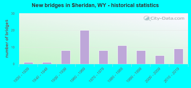
- New bridges - historical statistics
- 11930-1939
- 11940-1949
- 81950-1959
- 201960-1969
- 81970-1979
- 111980-1989
- 81990-1999
- 52000-2009
- 92010-2019
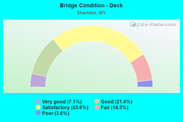
- Bridge Condition - Deck
- 7.1%Very good
- 21.4%Good
- 53.6%Satisfactory
- 14.3%Fair
- 3.6%Poor
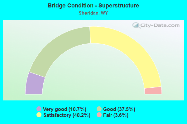
- Bridge Condition - Superstructure
- 10.7%Very good
- 37.5%Good
- 48.2%Satisfactory
- 3.6%Fair
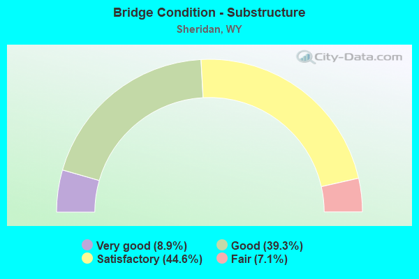
- Bridge Condition - Substructure
- 8.9%Very good
- 39.3%Good
- 44.6%Satisfactory
- 7.1%Fair
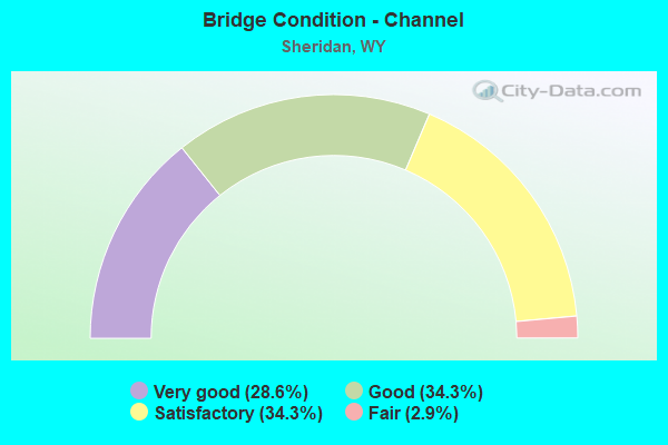
- Bridge Condition - Channel
- 28.6%Very good
- 34.3%Good
- 34.3%Satisfactory
- 2.9%Fair
Find on map >> Show street view
Structure Number: BBB, Location: Montana Line - Sheridan (Lat: 44.867417, Lng: -106.992794), Route carried "on" structure: Interstate 90, Year Built: 1959, Status: Posted for load, Structure Length: 2.06m (6.76ft), Average Daily Traffic: 2,177 (year 2021), Truck Traffic: 35%, Average Future Daily Traffic: 3,048 (year 2041), Design Load: HS 20+Mod, Features Intersected: Machinery Pass
Minimum Vertical Clearance: 30+ m (98+ ft), Kilometerpoint: 31.020, Lanes on structure: 2, Base Highway Network: Yes (Inventory Route: ML9, Subroute: 1), Owner: State Highway Agency, Approaching Roadway Width: 11.6m (38.1ft), Skew: 10 degrees, Material/Design: Concrete continuous, Design/Construction: Slab, Number Of Spans In Main Unit: 3, Length of Maximum Span: 7.6m (24.9ft), Curb-To-Curb Width: 11.6m (38.1ft), Out-to-Out Width: 12.5m (41.0ft)
Condition: Deck: Satisfactory, Superstructure: Satisfactory, Substructure: Satisfactory, Operating Rating: 44.7 metric tons, Method Used To Determine Operating Rating: Load Factor (LF), Inventory Rating: 26.8 metric tons, Method Used To Determine Inventory Rating: Load Factor (LF), Structural Evaluation: Equal to present minimum criteria, Deck Geometry: Equal to present minimum criteria, Approach Roadway Alignment: Equal to present desirable criteria, Designated Inspection Frequency: Every 24 months, Inspection Date: August 2021, Deck Structure Type: Concrete Cast-file-Place, Wearing Surface/Protective System: Wearing Surface: Latex Concrete
Find on map >> Show street view
Structure Number: BBC, Location: Montana Line - Sheridan (Lat: 44.867475, Lng: -106.992572), Route carried "on" structure: Interstate 90, Year Built: 1959, Status: Posted for load, Structure Length: 2.06m (6.76ft), Average Daily Traffic: 4,096 (year 2021), Truck Traffic: 17%, Average Future Daily Traffic: 5,734 (year 2041), Design Load: HS 20+Mod, Features Intersected: Machinery Pass
Minimum Vertical Clearance: 30+ m (98+ ft), Kilometerpoint: 30.977, Lanes on structure: 2, Base Highway Network: Yes (Inventory Route: ML9, Subroute: 1), Owner: State Highway Agency, Approaching Roadway Width: 11.6m (38.1ft), Skew: 10 degrees, Material/Design: Concrete continuous, Design/Construction: Slab, Number Of Spans In Main Unit: 3, Length of Maximum Span: 7.6m (24.9ft), Curb-To-Curb Width: 11.6m (38.1ft), Out-to-Out Width: 12.5m (41.0ft)
Condition: Deck: Satisfactory, Superstructure: Satisfactory, Substructure: Satisfactory, Operating Rating: 44.7 metric tons, Method Used To Determine Operating Rating: Load Factor (LF), Inventory Rating: 26.8 metric tons, Method Used To Determine Inventory Rating: Load Factor (LF), Structural Evaluation: Equal to present minimum criteria, Deck Geometry: Equal to present minimum criteria, Approach Roadway Alignment: Equal to present desirable criteria, Designated Inspection Frequency: Every 24 months, Inspection Date: August 2021, Deck Structure Type: Concrete Cast-file-Place, Wearing Surface/Protective System: Wearing Surface: Latex Concrete
Find on map >> Show street view
Structure Number: BBD, Location: Montana Line - Sheridan (Lat: 44.857658, Lng: -106.990042), Route carried "on" structure: Interstate 90, Year Built: 1959, Status: Posted for load, Structure Length: 2.06m (6.76ft), Average Daily Traffic: 2,177 (year 2021), Truck Traffic: 35%, Average Future Daily Traffic: 3,048 (year 2041), Design Load: HS 20+Mod, Features Intersected: Machinery Pass
Minimum Vertical Clearance: 30+ m (98+ ft), Kilometerpoint: 32.127, Lanes on structure: 2, Base Highway Network: Yes (Inventory Route: ML9, Subroute: 1), Owner: State Highway Agency, Approaching Roadway Width: 11.6m (38.1ft), Skew: 10 degrees, Material/Design: Concrete continuous, Design/Construction: Slab, Number Of Spans In Main Unit: 3, Length of Maximum Span: 7.6m (24.9ft), Curb-To-Curb Width: 11.6m (38.1ft), Out-to-Out Width: 12.5m (41.0ft)
Condition: Deck: Satisfactory, Superstructure: Satisfactory, Substructure: Satisfactory, Operating Rating: 42.5 metric tons, Method Used To Determine Operating Rating: Load Factor (LF), Inventory Rating: 25.5 metric tons, Method Used To Determine Inventory Rating: Load Factor (LF), Structural Evaluation: Equal to present minimum criteria, Deck Geometry: Equal to present minimum criteria, Approach Roadway Alignment: Equal to present desirable criteria, Designated Inspection Frequency: Every 24 months, Inspection Date: August 2021, Deck Structure Type: Concrete Cast-file-Place, Wearing Surface/Protective System: Wearing Surface: Latex Concrete
Find on map >> Show street view
Structure Number: BBE, Location: Montana Line - Sheridan (Lat: 44.857692, Lng: -106.989792), Route carried "on" structure: Interstate 90, Year Built: 1959, Status: Posted for load, Structure Length: 2.06m (6.76ft), Average Daily Traffic: 4,096 (year 2021), Truck Traffic: 17%, Average Future Daily Traffic: 5,734 (year 2041), Design Load: HS 20+Mod, Features Intersected: Machinery Pass
Minimum Vertical Clearance: 30+ m (98+ ft), Kilometerpoint: 32.087, Lanes on structure: 2, Base Highway Network: Yes (Inventory Route: ML9, Subroute: 1), Owner: State Highway Agency, Approaching Roadway Width: 11.6m (38.1ft), Skew: 10 degrees, Material/Design: Concrete continuous, Design/Construction: Slab, Number Of Spans In Main Unit: 3, Length of Maximum Span: 7.6m (24.9ft), Curb-To-Curb Width: 11.6m (38.1ft), Out-to-Out Width: 12.5m (41.0ft)
Condition: Deck: Satisfactory, Superstructure: Satisfactory, Substructure: Satisfactory, Operating Rating: 42.5 metric tons, Method Used To Determine Operating Rating: Load Factor (LF), Inventory Rating: 25.5 metric tons, Method Used To Determine Inventory Rating: Load Factor (LF), Structural Evaluation: Equal to present minimum criteria, Deck Geometry: Equal to present minimum criteria, Approach Roadway Alignment: Equal to present desirable criteria, Designated Inspection Frequency: Every 24 months, Inspection Date: August 2021, Deck Structure Type: Concrete Cast-file-Place, Wearing Surface/Protective System: Wearing Surface: Latex Concrete
Find on map >> Show street view
Structure Number: BBF, Location: Montana Line - Sheridan (Lat: 44.843547, Lng: -106.982289), Route carried "on" structure: Interstate 90, Year Built: 1959, Status: Posted for load, Structure Length: 2.06m (6.76ft), Average Daily Traffic: 2,500 (year 2021), Truck Traffic: 35%, Average Future Daily Traffic: 3,500 (year 2041), Design Load: HS 20+Mod, Features Intersected: Machinery Pass
Minimum Vertical Clearance: 30+ m (98+ ft), Kilometerpoint: 33.854, Lanes on structure: 2, Base Highway Network: Yes (Inventory Route: ML9, Subroute: 1), Owner: State Highway Agency, Approaching Roadway Width: 11.6m (38.1ft), Skew: 10 degrees, Material/Design: Concrete continuous, Design/Construction: Slab, Number Of Spans In Main Unit: 3, Length of Maximum Span: 7.6m (24.9ft), Curb-To-Curb Width: 11.6m (38.1ft), Out-to-Out Width: 12.5m (41.0ft)
Condition: Deck: Satisfactory, Superstructure: Satisfactory, Substructure: Satisfactory, Operating Rating: 42.5 metric tons, Method Used To Determine Operating Rating: Load Factor (LF), Inventory Rating: 25.5 metric tons, Method Used To Determine Inventory Rating: Load Factor (LF), Structural Evaluation: Equal to present minimum criteria, Deck Geometry: Equal to present minimum criteria, Approach Roadway Alignment: Equal to present desirable criteria, Designated Inspection Frequency: Every 24 months, Inspection Date: August 2021, Deck Structure Type: Concrete Cast-file-Place, Wearing Surface/Protective System: Wearing Surface: Latex Concrete
Find on map >> Show street view
Structure Number: BBG, Location: Montana Line - Sheridan (Lat: 44.843672, Lng: -106.982122), Route carried "on" structure: Interstate 90, Year Built: 1959, Status: Posted for load, Structure Length: 2.06m (6.76ft), Average Daily Traffic: 4,096 (year 2021), Truck Traffic: 17%, Average Future Daily Traffic: 5,734 (year 2041), Design Load: HS 20+Mod, Features Intersected: Machinery Pass
Minimum Vertical Clearance: 30+ m (98+ ft), Kilometerpoint: 33.799, Lanes on structure: 2, Base Highway Network: Yes (Inventory Route: ML9, Subroute: 1), Owner: State Highway Agency, Approaching Roadway Width: 11.6m (38.1ft), Skew: 10 degrees, Material/Design: Concrete continuous, Design/Construction: Slab, Number Of Spans In Main Unit: 3, Length of Maximum Span: 7.6m (24.9ft), Curb-To-Curb Width: 11.6m (38.1ft), Out-to-Out Width: 12.5m (41.0ft)
Condition: Deck: Satisfactory, Superstructure: Satisfactory, Substructure: Satisfactory, Operating Rating: 42.5 metric tons, Method Used To Determine Operating Rating: Load Factor (LF), Inventory Rating: 25.5 metric tons, Method Used To Determine Inventory Rating: Load Factor (LF), Structural Evaluation: Equal to present minimum criteria, Deck Geometry: Equal to present minimum criteria, Approach Roadway Alignment: Equal to present desirable criteria, Designated Inspection Frequency: Every 24 months, Inspection Date: August 2021, Deck Structure Type: Concrete Cast-file-Place, Wearing Surface/Protective System: Wearing Surface: Latex Concrete
Find on map >> Show street view
Structure Number: BBJ, Location: Montana Line - Sheridan (Lat: 44.833811, Lng: -106.964122), Route carried "on" structure: Interstate 90, Year Built: 1960, Status: Open, Structure Length: 5.26m (17.26ft), Average Daily Traffic: 2,732 (year 2021), Truck Traffic: 35%, Average Future Daily Traffic: 3,825 (year 2041), Design Load: HS 20+Mod, Features Intersected: Goose Creek
Minimum Vertical Clearance: 30+ m (98+ ft), Kilometerpoint: 35.653, Lanes on structure: 2, Base Highway Network: Yes (Inventory Route: ML9, Subroute: 1), Owner: State Highway Agency, Approaching Roadway Width: 11.6m (38.1ft), Skew: 10 degrees, Material/Design: Steel continuous, Design/Construction: Stringer/Multi-beam, Number Of Spans In Main Unit: 3, Length of Maximum Span: 19.8m (65.0ft), Curb-To-Curb Width: 11.6m (38.1ft), Out-to-Out Width: 14.3m (46.9ft)
Condition: Deck: Satisfactory, Superstructure: Satisfactory, Substructure: Satisfactory, Channel: Good, Operating Rating: 61.7 metric tons, Method Used To Determine Operating Rating: Load Factor (LF), Inventory Rating: 36.3 metric tons, Method Used To Determine Inventory Rating: Load Factor (LF), Structural Evaluation: Equal to present minimum criteria, Deck Geometry: Equal to present minimum criteria, Waterway Adequacy: Equal to present desirable criteria, Approach Roadway Alignment: Equal to present desirable criteria, Designated Inspection Frequency: Every 24 months, Inspection Date: August 2021, Deck Structure Type: Concrete Cast-file-Place, Wearing Surface/Protective System: Wearing Surface: Latex Concrete
Find on map >> Show street view
Structure Number: BBK, Location: Montana Line - Sheridan (Lat: 44.833961, Lng: -106.963956), Route carried "on" structure: Interstate 90, Year Built: 1960, Status: Open, Structure Length: 5.26m (17.26ft), Average Daily Traffic: 4,096 (year 2021), Truck Traffic: 17%, Average Future Daily Traffic: 5,734 (year 2041), Design Load: HS 20+Mod, Features Intersected: Goose Creek
Minimum Vertical Clearance: 30+ m (98+ ft), Kilometerpoint: 35.597, Lanes on structure: 2, Base Highway Network: Yes (Inventory Route: ML9, Subroute: 1), Owner: State Highway Agency, Approaching Roadway Width: 12.8m (42.0ft), Skew: 10 degrees, Material/Design: Steel continuous, Design/Construction: Stringer/Multi-beam, Number Of Spans In Main Unit: 3, Length of Maximum Span: 19.8m (65.0ft), Curb-To-Curb Width: 12.8m (42.0ft), Out-to-Out Width: 14.3m (46.9ft)
Condition: Deck: Good, Superstructure: Satisfactory, Substructure: Satisfactory, Channel: Good, Operating Rating: 51.7 metric tons, Method Used To Determine Operating Rating: Load Factor (LF), Inventory Rating: 30.8 metric tons, Method Used To Determine Inventory Rating: Load Factor (LF), Structural Evaluation: Equal to present minimum criteria, Deck Geometry: Equal to present desirable criteria, Waterway Adequacy: Equal to present desirable criteria, Approach Roadway Alignment: Equal to present desirable criteria, Designated Inspection Frequency: Every 24 months, Inspection Date: August 2021, Deck Structure Type: Concrete Cast-file-Place, Wearing Surface/Protective System: Wearing Surface: Latex Concrete
Find on map >> Show street view
Structure Number: BBP, Location: Sheridan (Lat: 44.821422, Lng: -106.942122), Route carried "on" structure: Interstate 90, Year Built: 1961, Status: Open, Structure Length: 2.85m (9.35ft), Average Daily Traffic: 3,250 (year 2021), Truck Traffic: 23%, Average Future Daily Traffic: 4,550 (year 2041), Design Load: HS 20+Mod, Features Intersected: Sh CR 121 / Gulch Road
Minimum Vertical Clearance: 30+ m (98+ ft), Kilometerpoint: 37.878, Lanes on structure: 2, Lanes under structure: 2, Base Highway Network: Yes (Inventory Route: ML9, Subroute: 1), Owner: State Highway Agency, Approaching Roadway Width: 11.6m (38.1ft), Skew: 10 degrees, Material/Design: Concrete continuous, Design/Construction: Slab, Number Of Spans In Main Unit: 3, Length of Maximum Span: 10.7m (35.1ft), Curb-To-Curb Width: 11.6m (38.1ft), Out-to-Out Width: 13.1m (43.0ft)
Condition: Deck: Satisfactory, Superstructure: Satisfactory, Substructure: Satisfactory, Operating Rating: 46.1 metric tons, Method Used To Determine Operating Rating: Load Factor (LF), Inventory Rating: 27.8 metric tons, Method Used To Determine Inventory Rating: Load Factor (LF), Structural Evaluation: Equal to present minimum criteria, Deck Geometry: Equal to present minimum criteria, Underclear: Meets minimum limits, Approach Roadway Alignment: Equal to present desirable criteria, Designated Inspection Frequency: Every 24 months, Inspection Date: August 2021, Deck Structure Type: Concrete Cast-file-Place, Wearing Surface/Protective System: Wearing Surface: Bituminous
Find on map >> Show street view
Structure Number: BBQ, Location: Sheridan (Lat: 44.821522, Lng: -106.941903), Route carried "on" structure: Interstate 90, Year Built: 1961, Status: Open, Structure Length: 2.85m (9.35ft), Average Daily Traffic: 4,096 (year 2021), Truck Traffic: 17%, Average Future Daily Traffic: 5,734 (year 2041), Design Load: HS 20+Mod, Features Intersected: Sh CR 121 / Gulch Road
Minimum Vertical Clearance: 30+ m (98+ ft), Kilometerpoint: 37.829, Lanes on structure: 2, Lanes under structure: 2, Base Highway Network: Yes (Inventory Route: ML9, Subroute: 1), Owner: State Highway Agency, Approaching Roadway Width: 11.6m (38.1ft), Skew: 10 degrees, Material/Design: Concrete continuous, Design/Construction: Slab, Number Of Spans In Main Unit: 3, Length of Maximum Span: 10.7m (35.1ft), Curb-To-Curb Width: 11.6m (38.1ft), Out-to-Out Width: 13.1m (43.0ft)
Condition: Deck: Satisfactory, Superstructure: Satisfactory, Substructure: Satisfactory, Operating Rating: 46.1 metric tons, Method Used To Determine Operating Rating: Load Factor (LF), Inventory Rating: 27.8 metric tons, Method Used To Determine Inventory Rating: Load Factor (LF), Structural Evaluation: Equal to present minimum criteria, Deck Geometry: Equal to present minimum criteria, Underclear: Meets minimum limits, Approach Roadway Alignment: Equal to present desirable criteria, Designated Inspection Frequency: Every 24 months, Inspection Date: August 2021, Deck Structure Type: Concrete Cast-file-Place, Wearing Surface/Protective System: Wearing Surface: Bituminous
Find on map >> Show street view
Structure Number: BBT, Location: Sheridan (Lat: 44.799181, Lng: -106.936878), Route carried "on" structure: Interstate 90, Year Built: 1961, Status: Open, Structure Length: 2.85m (9.35ft), Average Daily Traffic: 3,500 (year 2021), Truck Traffic: 23%, Average Future Daily Traffic: 4,900 (year 2041), Design Load: HS 20+Mod, Features Intersected: Kroe Lane
Minimum Vertical Clearance: 4.39m (14.40ft), Kilometerpoint: 40.407, Lanes on structure: 2, Lanes under structure: 2, Base Highway Network: Yes (Inventory Route: ML9, Subroute: 1), Owner: State Highway Agency, Approaching Roadway Width: 11.6m (38.1ft), Skew: 10 degrees, Material/Design: Concrete continuous, Design/Construction: Slab, Number Of Spans In Main Unit: 3, Length of Maximum Span: 10.7m (35.1ft), Curb-To-Curb Width: 11.6m (38.1ft), Out-to-Out Width: 13.1m (43.0ft)
Condition: Deck: Satisfactory, Superstructure: Satisfactory, Substructure: Satisfactory, Operating Rating: 46.7 metric tons, Method Used To Determine Operating Rating: Load Factor (LF), Inventory Rating: 28.1 metric tons, Method Used To Determine Inventory Rating: Load Factor (LF), Structural Evaluation: Equal to present minimum criteria, Deck Geometry: Equal to present minimum criteria, Underclear: High priority of corrective action, Approach Roadway Alignment: Equal to present desirable criteria, Designated Inspection Frequency: Every 24 months, Inspection Date: August 2021, Deck Structure Type: Concrete Cast-file-Place, Wearing Surface/Protective System: Wearing Surface: Bituminous
Find on map >> Show street view
Structure Number: BBU, Location: Sheridan (Lat: 44.799192, Lng: -106.936611), Route carried "on" structure: Interstate 90, Year Built: 1961, Status: Open, Structure Length: 2.85m (9.35ft), Average Daily Traffic: 4,096 (year 2021), Truck Traffic: 17%, Average Future Daily Traffic: 5,734 (year 2041), Design Load: HS 20+Mod, Features Intersected: Kroe Lane
Minimum Vertical Clearance: 30+ m (98+ ft), Kilometerpoint: 40.372, Lanes on structure: 2, Lanes under structure: 2, Base Highway Network: Yes (Inventory Route: ML9, Subroute: 1), Owner: State Highway Agency, Approaching Roadway Width: 11.6m (38.1ft), Skew: 10 degrees, Material/Design: Concrete continuous, Design/Construction: Slab, Number Of Spans In Main Unit: 3, Length of Maximum Span: 10.7m (35.1ft), Curb-To-Curb Width: 11.6m (38.1ft), Out-to-Out Width: 13.1m (43.0ft)
Condition: Deck: Satisfactory, Superstructure: Satisfactory, Substructure: Satisfactory, Operating Rating: 46.7 metric tons, Method Used To Determine Operating Rating: Load Factor (LF), Inventory Rating: 28.1 metric tons, Method Used To Determine Inventory Rating: Load Factor (LF), Structural Evaluation: Equal to present minimum criteria, Deck Geometry: Equal to present minimum criteria, Underclear: High priority of corrective action, Approach Roadway Alignment: Equal to present desirable criteria, Designated Inspection Frequency: Every 24 months, Inspection Date: August 2021, Deck Structure Type: Concrete Cast-file-Place, Wearing Surface/Protective System: Wearing Surface: Bituminous
Find on map >> Show street view
Structure Number: BBV, Location: Sheridan (Lat: 44.796544, Lng: -106.936842), Route carried "on" structure: Interstate 90, Year Built: 1962, Status: Open, Structure Length: 4.48m (14.70ft), Average Daily Traffic: 3,500 (year 2021), Truck Traffic: 23%, Average Future Daily Traffic: 4,900 (year 2041), Design Load: HS 20+Mod, Features Intersected: BNSF Railway
Minimum Vertical Clearance: 30+ m (98+ ft), Kilometerpoint: 40.700, Lanes on structure: 2, Base Highway Network: Yes (Inventory Route: ML9, Subroute: 1), Owner: State Highway Agency, Approaching Roadway Width: 11.6m (38.1ft), Skew: 12 degrees, Material/Design: Steel continuous, Design/Construction: Stringer/Multi-beam, Number Of Spans In Main Unit: 3, Length of Maximum Span: 16.8m (55.1ft), Curb-To-Curb Width: 11.6m (38.1ft), Out-to-Out Width: 13.1m (43.0ft)
Condition: Deck: Satisfactory, Superstructure: Satisfactory, Substructure: Satisfactory, Operating Rating: 59.9 metric tons, Method Used To Determine Operating Rating: Load Factor (LF), Inventory Rating: 35.4 metric tons, Method Used To Determine Inventory Rating: Load Factor (LF), Structural Evaluation: Equal to present minimum criteria, Deck Geometry: Equal to present minimum criteria, Underclear: Somewhat better than minimum adequacy, Approach Roadway Alignment: Equal to present desirable criteria, Designated Inspection Frequency: Every 24 months, Inspection Date: August 2021, Deck Structure Type: Concrete Cast-file-Place, Wearing Surface/Protective System: Wearing Surface: Latex Concrete
Find on map >> Show street view
Structure Number: BBW, Location: Sheridan (Lat: 44.796478, Lng: -106.936575), Route carried "on" structure: Interstate 90, Year Built: 1962, Status: Open, Structure Length: 4.48m (14.70ft), Average Daily Traffic: 4,096 (year 2021), Truck Traffic: 17%, Average Future Daily Traffic: 5,734 (year 2041), Design Load: HS 20+Mod, Features Intersected: BNSF Railway
Minimum Vertical Clearance: 30+ m (98+ ft), Kilometerpoint: 40.673, Lanes on structure: 2, Base Highway Network: Yes (Inventory Route: ML9, Subroute: 1), Owner: State Highway Agency, Approaching Roadway Width: 12.2m (40.0ft), Skew: 12 degrees, Material/Design: Steel continuous, Design/Construction: Stringer/Multi-beam, Number Of Spans In Main Unit: 3, Length of Maximum Span: 16.8m (55.1ft), Curb-To-Curb Width: 12.2m (40.0ft), Out-to-Out Width: 13.1m (43.0ft)
Condition: Deck: Satisfactory, Superstructure: Good, Substructure: Good, Operating Rating: 59.9 metric tons, Method Used To Determine Operating Rating: Load Factor (LF), Inventory Rating: 35.4 metric tons, Method Used To Determine Inventory Rating: Load Factor (LF), Structural Evaluation: Better than present minimum criteria, Deck Geometry: Better than present minimum criteria, Underclear: Somewhat better than minimum adequacy, Approach Roadway Alignment: Equal to present desirable criteria, Designated Inspection Frequency: Every 24 months, Inspection Date: August 2021, Deck Structure Type: Concrete Cast-file-Place, Wearing Surface/Protective System: Wearing Surface: Latex Concrete
Find on map >> Show street view
Structure Number: BBX, Location: Sheridan (Lat: 44.785225, Lng: -106.936786), Route carried "on" structure: Interstate 90, Year Built: 1961, Status: Open, Structure Length: 2.06m (6.76ft), Average Daily Traffic: 3,500 (year 2021), Truck Traffic: 17%, Average Future Daily Traffic: 4,900 (year 2041), Design Load: HS 20+Mod, Features Intersected: Machinery Pass
Minimum Vertical Clearance: 30+ m (98+ ft), Kilometerpoint: 41.957, Lanes on structure: 2, Base Highway Network: Yes (Inventory Route: ML9, Subroute: 1), Owner: State Highway Agency, Approaching Roadway Width: 11.6m (38.1ft), Skew: 10 degrees, Material/Design: Concrete continuous, Design/Construction: Slab, Number Of Spans In Main Unit: 3, Length of Maximum Span: 7.6m (24.9ft), Curb-To-Curb Width: 11.6m (38.1ft), Out-to-Out Width: 13.1m (43.0ft)
Condition: Deck: Satisfactory, Superstructure: Satisfactory, Substructure: Satisfactory, Operating Rating: 39.8 metric tons, Method Used To Determine Operating Rating: Load Factor (LF), Inventory Rating: 23.9 metric tons, Method Used To Determine Inventory Rating: Load Factor (LF), Structural Evaluation: Somewhat better than minimum adequacy, Deck Geometry: Equal to present minimum criteria, Approach Roadway Alignment: Equal to present desirable criteria, Designated Inspection Frequency: Every 24 months, Inspection Date: August 2021, Deck Structure Type: Concrete Cast-file-Place, Wearing Surface/Protective System: Wearing Surface: Bituminous
Find on map >> Show street view
Structure Number: BBY, Location: Sheridan (Lat: 44.785225, Lng: -106.936536), Route carried "on" structure: Interstate 90, Year Built: 1961, Status: Open, Structure Length: 2.06m (6.76ft), Average Daily Traffic: 4,096 (year 2021), Truck Traffic: 17%, Average Future Daily Traffic: 5,734 (year 2041), Design Load: HS 20+Mod, Features Intersected: Machinery Pass
Minimum Vertical Clearance: 30+ m (98+ ft), Kilometerpoint: 41.923, Lanes on structure: 2, Base Highway Network: Yes (Inventory Route: ML9, Subroute: 1), Owner: State Highway Agency, Approaching Roadway Width: 11.6m (38.1ft), Skew: 10 degrees, Material/Design: Concrete continuous, Design/Construction: Slab, Number Of Spans In Main Unit: 3, Length of Maximum Span: 7.6m (24.9ft), Curb-To-Curb Width: 11.6m (38.1ft), Out-to-Out Width: 13.1m (43.0ft)
Condition: Deck: Satisfactory, Superstructure: Satisfactory, Substructure: Satisfactory, Operating Rating: 39.8 metric tons, Method Used To Determine Operating Rating: Load Factor (LF), Inventory Rating: 23.9 metric tons, Method Used To Determine Inventory Rating: Load Factor (LF), Structural Evaluation: Somewhat better than minimum adequacy, Deck Geometry: Equal to present minimum criteria, Approach Roadway Alignment: Equal to present desirable criteria, Designated Inspection Frequency: Every 24 months, Inspection Date: August 2021, Deck Structure Type: Concrete Cast-file-Place, Wearing Surface/Protective System: Wearing Surface: Bituminous
Find on map >> Show street view
Structure Number: BBZ, Location: Sheridan (Lat: 44.773861, Lng: -106.936872), Route carried "on" structure: Interstate 90, Year Built: 1965, Status: Open, Structure Length: 4.45m (14.60ft), Average Daily Traffic: 3,500 (year 2021), Truck Traffic: 17%, Average Future Daily Traffic: 4,900 (year 2041), Design Load: HS 20+Mod, Features Intersected: US 14
Minimum Vertical Clearance: 30+ m (98+ ft), Kilometerpoint: 43.221, Lanes on structure: 2, Lanes under structure: 4, Base Highway Network: Yes (Inventory Route: ML9, Subroute: 1), Owner: State Highway Agency, Approaching Roadway Width: 11.6m (38.1ft), Skew: 10 degrees, Material/Design: Concrete continuous, Design/Construction: Slab, Number Of Spans In Main Unit: 3, Length of Maximum Span: 20.4m (66.9ft), Curb-To-Curb Width: 11.6m (38.1ft), Out-to-Out Width: 12.5m (41.0ft)
Condition: Deck: Satisfactory, Superstructure: Satisfactory, Substructure: Good, Operating Rating: 56.2 metric tons, Method Used To Determine Operating Rating: Load Factor (LF), Inventory Rating: 33.6 metric tons, Method Used To Determine Inventory Rating: Load Factor (LF), Structural Evaluation: Equal to present minimum criteria, Deck Geometry: Equal to present minimum criteria, Underclear: High priority of corrective action, Approach Roadway Alignment: Equal to present desirable criteria, Designated Inspection Frequency: Every 24 months, Inspection Date: August 2021, Deck Structure Type: Concrete Cast-file-Place, Wearing Surface/Protective System: Wearing Surface: Latex Concrete
Find on map >> Show street view
Structure Number: BCA, Location: Sheridan (Lat: 44.773858, Lng: -106.936603), Route carried "on" structure: Interstate 90, Year Built: 1965, Status: Open, Structure Length: 4.45m (14.60ft), Average Daily Traffic: 4,096 (year 2021), Truck Traffic: 17%, Average Future Daily Traffic: 5,734 (year 2041), Design Load: HS 20+Mod, Features Intersected: US 14
Minimum Vertical Clearance: 30+ m (98+ ft), Kilometerpoint: 43.185, Lanes on structure: 2, Lanes under structure: 4, Base Highway Network: Yes (Inventory Route: ML9, Subroute: 1), Owner: State Highway Agency, Approaching Roadway Width: 11.6m (38.1ft), Skew: 10 degrees, Material/Design: Concrete, Design/Construction: Slab, Number Of Spans In Main Unit: 3, Length of Maximum Span: 20.4m (66.9ft), Curb-To-Curb Width: 11.6m (38.1ft), Out-to-Out Width: 12.5m (41.0ft)
Condition: Deck: Satisfactory, Superstructure: Satisfactory, Substructure: Satisfactory, Operating Rating: 56.2 metric tons, Method Used To Determine Operating Rating: Load Factor (LF), Inventory Rating: 33.6 metric tons, Method Used To Determine Inventory Rating: Load Factor (LF), Structural Evaluation: Equal to present minimum criteria, Deck Geometry: Equal to present minimum criteria, Underclear: High priority of corrective action, Approach Roadway Alignment: Equal to present desirable criteria, Designated Inspection Frequency: Every 24 months, Inspection Date: August 2021, Deck Structure Type: Concrete Cast-file-Place, Wearing Surface/Protective System: Wearing Surface: Latex Concrete
Find on map >> Show street view
Structure Number: BMS, Location: Sheridan (Lat: 44.802756, Lng: -106.955786), Route carried "on" structure: Business US 90, Year Built: 1954, Status: Open, Structure Length: 1.68m (5.51ft), Average Daily Traffic: 8,866 (year 2021), Truck Traffic: 6%, Average Future Daily Traffic: 12,412 (year 2041), Design Load: HS 20, Features Intersected: Little Goose Creek, Facility Carried by Structure: US 87 Bus
Minimum Vertical Clearance: 30+ m (98+ ft), Kilometerpoint: 36.835, Lanes on structure: 4, Base Highway Network: Yes, Owner: State Highway Agency, Approaching Roadway Width: 18.3m (60.0ft), Skew: 20 degrees, Material/Design: Concrete, Design/Construction: Frame, Number Of Spans In Main Unit: 1, Length of Maximum Span: 15.2m (49.9ft), Curb or Sidewalk Widths: Left: 2.4m (7.9ft), Right: 2.4m (7.9ft), Curb-To-Curb Width: 19.2m (63.0ft), Out-to-Out Width: 24.6m (80.7ft)
Condition: Deck: Satisfactory, Superstructure: Satisfactory, Substructure: Good, Channel: Very good, Operating Rating: 71.7 metric tons, Method Used To Determine Operating Rating: Load Factor (LF), Inventory Rating: 42.6 metric tons, Method Used To Determine Inventory Rating: Load Factor (LF), Structural Evaluation: Equal to present minimum criteria, Deck Geometry: Equal to present minimum criteria, Waterway Adequacy: Equal to present desirable criteria, Approach Roadway Alignment: Equal to present desirable criteria, Designated Inspection Frequency: Every 24 months, Inspection Date: July 2020, Deck Structure Type: Concrete Cast-file-Place, Wearing Surface/Protective System: Wearing Surface: Latex Concrete
Find on map >> Show street view
Structure Number: CUO, Location: 5th St. - Sheridan (Lat: 44.806906, Lng: -106.959286), Route carried "on" structure: State highway U0330, Year Built: 1968, Status: Open, Structure Length: 6.22m (20.41ft), Average Daily Traffic: 9,819 (year 2021), Truck Traffic: 4%, Average Future Daily Traffic: 13,747 (year 2041), Design Load: HS 20, Features Intersected: Big Goose Creek, Facility Carried by Structure: 5th Street
Minimum Vertical Clearance: 30+ m (98+ ft), Kilometerpoint: 0.283, Lanes on structure: 2, Owner: City or Municipal Highway Agency, Approaching Roadway Width: 14.6m (47.9ft), Skew: 4 degrees, Material/Design: Concrete continuous, Design/Construction: Box Beam or Girders - Multiple, Number Of Spans In Main Unit: 3, Length of Maximum Span: 29.0m (95.1ft), Curb or Sidewalk Widths: Left: 1.5m (4.9ft), Right: 1.5m (4.9ft), Curb-To-Curb Width: 13.1m (43.0ft), Out-to-Out Width: 17.0m (55.8ft)
Condition: Deck: Satisfactory, Superstructure: Satisfactory, Substructure: Satisfactory, Channel: Good, Operating Rating: 59.9 metric tons, Method Used To Determine Operating Rating: Load Factor (LF), Inventory Rating: 35.4 metric tons, Method Used To Determine Inventory Rating: Load Factor (LF), Structural Evaluation: Equal to present minimum criteria, Deck Geometry: Somewhat better than minimum adequacy, Waterway Adequacy: Equal to present desirable criteria, Approach Roadway Alignment: Better than present minimum criteria, Designated Inspection Frequency: Every 24 months, Inspection Date: April 2020, Deck Structure Type: Concrete Cast-file-Place, Wearing Surface/Protective System: Wearing Surface: Latex Concrete
Find on map >> Show street view
Structure Number: CUQ, Location: Sheridan - Beckton (Lat: 44.776886, Lng: -107.029617), Route carried "on" structure: State highway 331, Year Built: 1970, Status: Open, Structure Length: 3.57m (11.71ft), Average Daily Traffic: 1,552 (year 2021), Truck Traffic: 10%, Average Future Daily Traffic: 2,173 (year 2041), Design Load: HS 20, Features Intersected: Big Goose Creek
Minimum Vertical Clearance: 30+ m (98+ ft), Kilometerpoint: 6.503, Lanes on structure: 2, Owner: State Highway Agency, Approaching Roadway Width: 9.8m (32.2ft), Skew: 4 degrees, Material/Design: Concrete continuous, Design/Construction: Stringer/Multi-beam, Number Of Spans In Main Unit: 3, Length of Maximum Span: 14.3m (46.9ft), Curb-To-Curb Width: 9.8m (32.2ft), Out-to-Out Width: 10.7m (35.1ft)
Condition: Deck: Good, Superstructure: Good, Substructure: Good, Channel: Good, Operating Rating: 48.1 metric tons, Method Used To Determine Operating Rating: Load Factor (LF), Inventory Rating: 29.9 metric tons, Method Used To Determine Inventory Rating: Load Factor (LF), Structural Evaluation: Better than present minimum criteria, Deck Geometry: Somewhat better than minimum adequacy, Waterway Adequacy: Equal to present desirable criteria, Approach Roadway Alignment: Equal to present desirable criteria, Designated Inspection Frequency: Every 24 months, Inspection Date: June 2020, Bridge Improvement Cost: $77,000, Roadway Improvement Cost: $8,000, Total Project Cost: $92,000, Deck Structure Type: Concrete Cast-file-Place, Wearing Surface/Protective System: Wearing Surface: Latex Concrete
Find on map >> Show street view
Structure Number: CUR, Location: Sheridan - Beckton (Lat: 44.763747, Lng: -107.073947), Route carried "on" structure: State highway 331, Year Built: 1970, Status: Open, Structure Length: 3.23m (10.60ft), Average Daily Traffic: 1,552 (year 2021), Truck Traffic: 10%, Average Future Daily Traffic: 2,173 (year 2041), Design Load: HS 20, Features Intersected: Big Goose Creek
Minimum Vertical Clearance: 30+ m (98+ ft), Kilometerpoint: 10.459, Lanes on structure: 2, Owner: State Highway Agency, Approaching Roadway Width: 9.8m (32.2ft), Skew: 1 degrees, Material/Design: Concrete continuous, Design/Construction: Stringer/Multi-beam, Number Of Spans In Main Unit: 3, Length of Maximum Span: 13.1m (43.0ft), Curb-To-Curb Width: 9.8m (32.2ft), Out-to-Out Width: 10.7m (35.1ft)
Condition: Deck: Good, Superstructure: Fair, Substructure: Good, Channel: Satisfactory, Operating Rating: 62.6 metric tons, Method Used To Determine Operating Rating: Load Factor (LF), Inventory Rating: 38.1 metric tons, Method Used To Determine Inventory Rating: Load Factor (LF), Structural Evaluation: Somewhat better than minimum adequacy, Deck Geometry: Somewhat better than minimum adequacy, Waterway Adequacy: Equal to present desirable criteria, Approach Roadway Alignment: Equal to present desirable criteria, Length Of Structure Improvement: 0.30m (0.98ft), Designated Inspection Frequency: Every 24 months, Inspection Date: July 2020, Bridge Improvement Cost: $52,000, Roadway Improvement Cost: $5,000, Total Project Cost: $62,000, Deck Structure Type: Concrete Cast-file-Place, Wearing Surface/Protective System: Wearing Surface: Latex Concrete
Find on map >> Show street view
Structure Number: CUT, Location: Sheridan - East (Lat: 44.822125, Lng: -106.899733), Route carried "on" structure: State highway 336, Year Built: 1956, Status: Open, Structure Length: 3.05m (10.01ft), Average Daily Traffic: 596 (year 2021), Truck Traffic: 5%, Average Future Daily Traffic: 834 (year 2041), Design Load: H 20, Features Intersected: Prairie Dog Creek
Minimum Vertical Clearance: 30+ m (98+ ft), Kilometerpoint: 5.485, Lanes on structure: 2, Owner: State Highway Agency, Approaching Roadway Width: 7.9m (25.9ft), Skew: 3 degrees, Material/Design: Concrete continuous, Design/Construction: Slab, Number Of Spans In Main Unit: 4, Length of Maximum Span: 8.1m (26.6ft), Curb-To-Curb Width: 8.5m (27.9ft), Out-to-Out Width: 9.5m (31.2ft)
Condition: Deck: Good, Superstructure: Good, Substructure: Satisfactory, Channel: Satisfactory, Operating Rating: 40.2 metric tons, Method Used To Determine Operating Rating: Load Factor (LF), Inventory Rating: 24.1 metric tons, Method Used To Determine Inventory Rating: Load Factor (LF), Structural Evaluation: Equal to present minimum criteria, Deck Geometry: Somewhat better than minimum adequacy, Waterway Adequacy: Equal to present desirable criteria, Approach Roadway Alignment: Equal to present desirable criteria, Length Of Structure Improvement: 3.05m (10.01ft), Designated Inspection Frequency: Every 24 months, Inspection Date: June 2020, Bridge Improvement Cost: $72,000, Roadway Improvement Cost: $7,000, Total Project Cost: $86,000 ( Estimate for 2015), Deck Structure Type: Concrete Cast-file-Place, Wearing Surface/Protective System: Wearing Surface: Bituminous
Find on map >> Show street view
Structure Number: CUW, Location: Ft Mackenzie Rd Sheridan (Lat: 44.821083, Lng: -106.961419), Route carried "on" structure: City street 337, Year Built: 1971, Status: Open, Structure Length: 4.42m (14.50ft), Average Daily Traffic: 2,571 (year 2021), Truck Traffic: 12%, Average Future Daily Traffic: 3,599 (year 2041), Design Load: HS 20, Features Intersected: Goose Creek
Minimum Vertical Clearance: 30+ m (98+ ft), Kilometerpoint: 0.472, Lanes on structure: 2, Owner: Town or Township Highway Agency, Approaching Roadway Width: 12.1m (39.7ft), Material/Design: Steel continuous, Design/Construction: Stringer/Multi-beam, Number Of Spans In Main Unit: 3, Length of Maximum Span: 18.3m (60.0ft), Curb or Sidewalk Widths: Left: 1.5m (4.9ft), Right: 0.0m, Curb-To-Curb Width: 12.2m (40.0ft), Out-to-Out Width: 14.9m (48.9ft)
Condition: Deck: Satisfactory, Superstructure: Good, Substructure: Good, Channel: Satisfactory, Operating Rating: 49.9 metric tons, Method Used To Determine Operating Rating: Allowable Stress (AS), Inventory Rating: 33.6 metric tons, Method Used To Determine Inventory Rating: Allowable Stress (AS), Structural Evaluation: Better than present minimum criteria, Deck Geometry: Equal to present minimum criteria, Waterway Adequacy: Equal to present desirable criteria, Approach Roadway Alignment: Equal to present desirable criteria, Designated Inspection Frequency: Every 24 months, Inspection Date: April 2021, Deck Structure Type: Concrete Cast-file-Place
Find on map >> Show street view
Structure Number: CVC, Location: Jct Wyo 338 - Jct I-90 (Lat: 44.882586, Lng: -106.987289), Route carried "on" structure: State highway 339, Year Built: 1966, Status: Open, Structure Length: 4.08m (13.39ft), Average Daily Traffic: 383 (year 2021), Truck Traffic: 10%, Average Future Daily Traffic: 536 (year 2041), Design Load: H 15, Features Intersected: Goose Creek
Minimum Vertical Clearance: 30+ m (98+ ft), Kilometerpoint: 0.080, Lanes on structure: 2, Owner: State Highway Agency, Approaching Roadway Width: 9.8m (32.2ft), Material/Design: Steel continuous, Design/Construction: Stringer/Multi-beam, Number Of Spans In Main Unit: 3, Length of Maximum Span: 15.2m (49.9ft), Curb-To-Curb Width: 9.8m (32.2ft), Out-to-Out Width: 10.6m (34.8ft)
Condition: Deck: Good, Superstructure: Good, Substructure: Good, Channel: Very good, Operating Rating: 52.6 metric tons, Method Used To Determine Operating Rating: Load Factor (LF), Inventory Rating: 30.8 metric tons, Method Used To Determine Inventory Rating: Load Factor (LF), Structural Evaluation: Better than present minimum criteria, Deck Geometry: Better than present minimum criteria, Waterway Adequacy: Equal to present desirable criteria, Approach Roadway Alignment: Equal to present desirable criteria, Designated Inspection Frequency: Every 24 months, Inspection Date: June 2020, Deck Structure Type: Concrete Cast-file-Place, Wearing Surface/Protective System: Wearing Surface: Epoxy Overlay
Find on map >> Show street view
Structure Number: CZY, Location: Sheridan - Banner (Lat: 44.737511, Lng: -106.947350), Route carried "on" structure: US 87, Year Built: 1939, Status: Open, Structure Length: 3.26m (10.70ft), Average Daily Traffic: 5,500 (year 2021), Truck Traffic: 8%, Average Future Daily Traffic: 7,700 (year 2041), Design Load: HS 20, Features Intersected: Little Goose Creek
Minimum Vertical Clearance: 30+ m (98+ ft), Kilometerpoint: 44.574, Lanes on structure: 2, Owner: State Highway Agency, Approaching Roadway Width: 12.2m (40.0ft), Material/Design: Steel, Design/Construction: Stringer/Multi-beam, Number Of Spans In Main Unit: 3, Length of Maximum Span: 10.4m (34.1ft), Curb-To-Curb Width: 9.1m (29.9ft), Out-to-Out Width: 10.2m (33.5ft)
Condition: Deck: Satisfactory, Superstructure: Satisfactory, Substructure: Fair, Channel: Satisfactory, Operating Rating: 51.7 metric tons, Method Used To Determine Operating Rating: Load Factor (LF), Inventory Rating: 30.8 metric tons, Method Used To Determine Inventory Rating: Load Factor (LF), Structural Evaluation: Somewhat better than minimum adequacy, Deck Geometry: High priority of corrective action, Waterway Adequacy: Equal to present desirable criteria, Approach Roadway Alignment: Equal to present desirable criteria, Length Of Structure Improvement: 3.26m (10.70ft), Designated Inspection Frequency: Every 24 months, Inspection Date: July 2020, Bridge Improvement Cost: $28,000, Roadway Improvement Cost: $6,000, Total Project Cost: $50,000 ( Estimate for 2015), Deck Structure Type: Concrete Cast-file-Place, Wearing Surface/Protective System: Wearing Surface: Bituminous, Membrane: Preformed Fabric
Find on map >> Show street view
Structure Number: CZZ, Location: Sheridan - Banner (Lat: 44.712561, Lng: -106.957853), Route carried "on" structure: US 87, Year Built: 1946, Status: Open, Structure Length: 3.93m (12.89ft), Average Daily Traffic: 1,716 (year 2021), Truck Traffic: 4%, Average Future Daily Traffic: 2,402 (year 2041), Design Load: H 15, Features Intersected: Little Goose Creek
Minimum Vertical Clearance: 30+ m (98+ ft), Kilometerpoint: 47.802, Lanes on structure: 2, Owner: State Highway Agency, Approaching Roadway Width: 9.1m (29.9ft), Material/Design: Steel, Design/Construction: Stringer/Multi-beam, Number Of Spans In Main Unit: 3, Length of Maximum Span: 14.6m (47.9ft), Curb-To-Curb Width: 9.1m (29.9ft), Out-to-Out Width: 10.7m (35.1ft)
Condition: Deck: Satisfactory, Superstructure: Satisfactory, Substructure: Good, Channel: Good, Operating Rating: 43.5 metric tons, Method Used To Determine Operating Rating: Load Factor (LF), Inventory Rating: 26.3 metric tons, Method Used To Determine Inventory Rating: Load Factor (LF), Structural Evaluation: Equal to present minimum criteria, Deck Geometry: Somewhat better than minimum adequacy, Waterway Adequacy: Equal to present desirable criteria, Approach Roadway Alignment: Equal to present desirable criteria, Length Of Structure Improvement: 2.44m (8.01ft), Designated Inspection Frequency: Every 24 months, Inspection Date: July 2020, Bridge Improvement Cost: $116,000, Roadway Improvement Cost: $12,000, Total Project Cost: $174,000, Deck Structure Type: Concrete Cast-file-Place, Wearing Surface/Protective System: Wearing Surface: Latex Concrete
Find on map >> Show street view
Structure Number: DEM, Location: Sheridan (Lat: 44.786056, Lng: -106.942997), Route carried "on" structure: Business US 90, Year Built: 1980, Status: Open, Structure Length: 4.27m (14.01ft), Average Daily Traffic: 19,376 (year 2021), Truck Traffic: 1%, Average Future Daily Traffic: 27,126 (year 2041), Design Load: HS 20, Features Intersected: Little Goose Creek, Facility Carried by Structure: US 87 Bus
Minimum Vertical Clearance: 30+ m (98+ ft), Kilometerpoint: 39.123, Lanes on structure: 5, Base Highway Network: Yes (Inventory Route: ML6, Subroute: 1), Owner: State Highway Agency, Approaching Roadway Width: 20.7m (67.9ft), Skew: 2 degrees, Material/Design: Steel continuous, Design/Construction: Stringer/Multi-beam, Number Of Spans In Main Unit: 3, Length of Maximum Span: 16.5m (54.1ft), Curb or Sidewalk Widths: Left: 1.5m (4.9ft), Right: 1.5m (4.9ft), Curb-To-Curb Width: 20.2m (66.3ft), Out-to-Out Width: 24.4m (80.1ft)
Condition: Deck: Good, Superstructure: Good, Substructure: Good, Channel: Very good, Operating Rating: 55.3 metric tons, Method Used To Determine Operating Rating: Load Factor (LF), Inventory Rating: 34.5 metric tons, Method Used To Determine Inventory Rating: Load Factor (LF), Structural Evaluation: Better than present minimum criteria, Deck Geometry: Somewhat better than minimum adequacy, Waterway Adequacy: Equal to present desirable criteria, Approach Roadway Alignment: Equal to present desirable criteria, Designated Inspection Frequency: Every 24 months, Inspection Date: June 2020, Deck Structure Type: Concrete Cast-file-Place, Wearing Surface/Protective System: Wearing Surface: Latex Concrete
Find on map >> Show street view
Structure Number: DKK, Location: Val Vista Lane St. (Lat: 44.802631, Lng: -106.957258), Route carried "on" structure: City street 4413, Year Built: 1970, Status: Open, Structure Length: 1.71m (5.61ft), Average Daily Traffic: 4,346 (year 2021), Truck Traffic: 2%, Average Future Daily Traffic: 6,084 (year 2041), Features Intersected: Little Goose Creek, Facility Carried by Structure: N. Brooks Street
Minimum Vertical Clearance: 30+ m (98+ ft), Kilometerpoint: 161.535, Lanes on structure: 2, Owner: Town or Township Highway Agency, Approaching Roadway Width: 17.4m (57.1ft), Material/Design: Steel, Design/Construction: Stringer/Multi-beam, Number Of Spans In Main Unit: 1, Length of Maximum Span: 16.5m (54.1ft), Curb or Sidewalk Widths: Left: 1.2m (3.9ft), Right: 1.2m (3.9ft), Curb-To-Curb Width: 11.0m (36.1ft), Out-to-Out Width: 14.1m (46.3ft)
Condition: Deck: Poor, Superstructure: Satisfactory, Substructure: Satisfactory, Channel: Good, Operating Rating: 38.1 metric tons, Method Used To Determine Operating Rating: Allowable Stress (AS), Inventory Rating: 23.6 metric tons, Method Used To Determine Inventory Rating: Allowable Stress (AS), Structural Evaluation: Equal to present minimum criteria, Deck Geometry: Somewhat better than minimum adequacy, Waterway Adequacy: Equal to present desirable criteria, Approach Roadway Alignment: Equal to present desirable criteria, Length Of Structure Improvement: 1.71m (5.61ft), Designated Inspection Frequency: Every 24 months, Inspection Date: April 2021, Bridge Improvement Cost: $16,000, Roadway Improvement Cost: $1,000, Total Project Cost: $19,000, Deck Structure Type: Concrete Cast-file-Place
Find on map >> Show street view
Structure Number: DKQ, Location: Loucks Street Sheridan (Lat: 44.797356, Lng: -106.965864), Route carried "on" structure: City street 331, Year Built: 1970, Status: Open, Structure Length: 2.23m (7.32ft), Average Daily Traffic: 4,942 (year 2021), Truck Traffic: 4%, Average Future Daily Traffic: 6,919 (year 2041), Features Intersected: Big Goose Creek
Minimum Vertical Clearance: 30+ m (98+ ft), Kilometerpoint: 0.792, Lanes on structure: 2, Owner: Town or Township Highway Agency, Approaching Roadway Width: 11.9m (39.0ft), Material/Design: Concrete continuous, Design/Construction: Tee Beam, Number Of Spans In Main Unit: 3, Length of Maximum Span: 12.2m (40.0ft), Curb or Sidewalk Widths: Left: 1.4m (4.6ft), Right: 1.4m (4.6ft), Curb-To-Curb Width: 11.9m (39.0ft), Out-to-Out Width: 15.5m (50.9ft)
Condition: Deck: Good, Superstructure: Very good, Substructure: Fair, Channel: Satisfactory, Operating Rating: 54.2 metric tons, Method Used To Determine Operating Rating: Field evaluation and documented engineering judgment, Inventory Rating: 32.7 metric tons, Method Used To Determine Inventory Rating: Field evaluation and documented engineering judgment, Structural Evaluation: Somewhat better than minimum adequacy, Deck Geometry: Somewhat better than minimum adequacy, Waterway Adequacy: Equal to present desirable criteria, Approach Roadway Alignment: Equal to present desirable criteria, Designated Inspection Frequency: Every 24 months, Inspection Date: April 2020, Deck Structure Type: Concrete Precast Panels, Wearing Surface/Protective System: Wearing Surface: Monolithic Concrete
Find on map >> Show street view
Structure Number: DKS, Location: Downer Addt Road Sheridan (Lat: 44.819672, Lng: -106.962603), Route carried "on" structure: County highway 4418, Year Built: 1970, Status: Open, Structure Length: 1.31m (4.30ft), Average Daily Traffic: 1,202 (year 2021), Truck Traffic: 10%, Average Future Daily Traffic: 1,683 (year 2041), Design Load: HS 20, Features Intersected: Soldier Creek, Facility Carried by Structure: 8th Street
Minimum Vertical Clearance: 30+ m (98+ ft), Kilometerpoint: 163.422, Lanes on structure: 2, Owner: County Highway Agency, Approaching Roadway Width: 7.3m (24.0ft), Material/Design: Steel, Design/Construction: Stringer/Multi-beam, Number Of Spans In Main Unit: 1, Length of Maximum Span: 12.5m (41.0ft), Curb-To-Curb Width: 7.3m (24.0ft), Out-to-Out Width: 8.1m (26.6ft)
Condition: Deck: Good, Superstructure: Satisfactory, Substructure: Fair, Channel: Satisfactory, Operating Rating: 49.0 metric tons, Method Used To Determine Operating Rating: Allowable Stress (AS), Inventory Rating: 34.5 metric tons, Method Used To Determine Inventory Rating: Allowable Stress (AS), Structural Evaluation: Somewhat better than minimum adequacy, Deck Geometry: Meets minimum limits, Waterway Adequacy: Better than present minimum criteria, Approach Roadway Alignment: Equal to present desirable criteria, Length Of Structure Improvement: 5.03m (16.50ft), Designated Inspection Frequency: Every 24 months, Inspection Date: April 2021, Bridge Improvement Cost: $5,000, Roadway Improvement Cost: $1,000, Total Project Cost: $7,000, Deck Structure Type: Concrete Cast-file-Place, Wearing Surface/Protective System: Wearing Surface: Bituminous
Find on map >> Show street view
Structure Number: DLG, Location: Sheridan - Ucross (Lat: 44.730456, Lng: -106.874672), Route carried "on" structure: US 14, Year Built: 1981, Status: Open, Structure Length: 2.77m (9.09ft), Average Daily Traffic: 1,176 (year 2021), Truck Traffic: 6%, Average Future Daily Traffic: 1,646 (year 2041), Design Load: HS 20, Features Intersected: Prairie Dog Creek
Minimum Vertical Clearance: 30+ m (98+ ft), Kilometerpoint: 7.879, Lanes on structure: 2, Owner: State Highway Agency, Approaching Roadway Width: 11.0m (36.1ft), Material/Design: Steel continuous, Design/Construction: Stringer/Multi-beam, Number Of Spans In Main Unit: 3, Length of Maximum Span: 10.7m (35.1ft), Curb-To-Curb Width: 11.0m (36.1ft), Out-to-Out Width: 11.9m (39.0ft)
Condition: Deck: Fair, Superstructure: Very good, Substructure: Good, Channel: Satisfactory, Operating Rating: 65.3 metric tons, Method Used To Determine Operating Rating: Load Factor (LF), Inventory Rating: 39.0 metric tons, Method Used To Determine Inventory Rating: Load Factor (LF), Structural Evaluation: Better than present minimum criteria, Deck Geometry: Equal to present minimum criteria, Waterway Adequacy: Equal to present desirable criteria, Approach Roadway Alignment: Equal to present desirable criteria, Designated Inspection Frequency: Every 24 months, Inspection Date: July 2020, Deck Structure Type: Concrete Cast-file-Place
Find on map >> Show street view
Structure Number: EAY, Location: Sheridan Streets (Lat: 44.796322, Lng: -106.947094), Route carried "on" structure: City street 400-1, Year Built: 1970, Status: Open, Structure Length: 2.38m (7.81ft), Average Daily Traffic: 622 (year 2021), Truck Traffic: 5%, Average Future Daily Traffic: 871 (year 2041), Features Intersected: Little Goose Creek, Facility Carried by Structure: E. Works Street
Minimum Vertical Clearance: 30+ m (98+ ft), Kilometerpoint: 161.630, Lanes on structure: 2, Owner: Town or Township Highway Agency, Approaching Roadway Width: 11.6m (38.1ft), Material/Design: Concrete continuous, Design/Construction: Tee Beam, Number Of Spans In Main Unit: 3, Length of Maximum Span: 13.7m (44.9ft), Curb or Sidewalk Widths: Left: 1.8m (5.9ft), Right: 0.5m (1.6ft), Curb-To-Curb Width: 7.3m (24.0ft), Out-to-Out Width: 9.6m (31.5ft)
Condition: Deck: Poor, Superstructure: Good, Substructure: Satisfactory, Channel: Very good, Operating Rating: 48.6 metric tons, Method Used To Determine Operating Rating: Load Factor (LF), Inventory Rating: 29.0 metric tons, Method Used To Determine Inventory Rating: Load Factor (LF), Structural Evaluation: Equal to present minimum criteria, Deck Geometry: Meets minimum limits, Waterway Adequacy: Equal to present desirable criteria, Approach Roadway Alignment: Better than present minimum criteria, Length Of Structure Improvement: 2.38m (7.81ft), Designated Inspection Frequency: Every 24 months, Inspection Date: April 2020, Bridge Improvement Cost: $36,000, Roadway Improvement Cost: $1,000, Total Project Cost: $41,000 ( Estimate for 2014), Deck Structure Type: Concrete Cast-file-Place, Wearing Surface/Protective System: Wearing Surface: Bituminous
Find on map >> Show street view
Structure Number: EAZ, Location: Sheridan Streets (Lat: 44.790544, Lng: -106.945983), Route carried "on" structure: City street 400-3, Year Built: 1970, Status: Open, Structure Length: 2.38m (7.81ft), Average Daily Traffic: 1,819 (year 2021), Truck Traffic: 3%, Average Future Daily Traffic: 2,547 (year 2041), Design Load: H 20, Features Intersected: Little Goose Creek, Facility Carried by Structure: E. Heald Street
Minimum Vertical Clearance: 30+ m (98+ ft), Kilometerpoint: 161.723, Lanes on structure: 2, Owner: Town or Township Highway Agency, Approaching Roadway Width: 11.3m (37.1ft), Material/Design: Concrete continuous, Design/Construction: Tee Beam, Number Of Spans In Main Unit: 3, Length of Maximum Span: 13.7m (44.9ft), Curb or Sidewalk Widths: Left: 1.8m (5.9ft), Right: 0.5m (1.6ft), Curb-To-Curb Width: 7.3m (24.0ft), Out-to-Out Width: 9.6m (31.5ft)
Condition: Deck: Satisfactory, Superstructure: Satisfactory, Substructure: Satisfactory, Channel: Very good, Operating Rating: 41.7 metric tons, Method Used To Determine Operating Rating: Allowable Stress (AS), Inventory Rating: 24.5 metric tons, Method Used To Determine Inventory Rating: Allowable Stress (AS), Structural Evaluation: Equal to present minimum criteria, Deck Geometry: Meets minimum limits, Waterway Adequacy: Equal to present desirable criteria, Approach Roadway Alignment: Better than present minimum criteria, Length Of Structure Improvement: 2.38m (7.81ft), Designated Inspection Frequency: Every 24 months, Inspection Date: April 2020, Bridge Improvement Cost: $42,000, Roadway Improvement Cost: $1,000, Total Project Cost: $47,000 ( Estimate for 2014), Deck Structure Type: Concrete Cast-file-Place, Wearing Surface/Protective System: Wearing Surface: Bituminous
Find on map >> Show street view
Structure Number: EXO, Location: 2 Miles S. Of Sheridan (Lat: 44.747933, Lng: -106.955525), Route carried "on" structure: County highway 66, Year Built: 1984, Status: Open, Structure Length: 2.07m (6.79ft), Average Daily Traffic: 704 (year 2021), Truck Traffic: 10%, Average Future Daily Traffic: 986 (year 2041), Design Load: HS 20, Features Intersected: Little Goose Creek
Minimum Vertical Clearance: 30+ m (98+ ft), Kilometerpoint: 0.674, Lanes on structure: 2, Owner: County Highway Agency, Approaching Roadway Width: 8.5m (27.9ft), Material/Design: Steel, Design/Construction: Stringer/Multi-beam, Number Of Spans In Main Unit: 1, Length of Maximum Span: 20.1m (65.9ft), Curb-To-Curb Width: 9.1m (29.9ft), Out-to-Out Width: 11.8m (38.7ft)
Condition: Deck: Good, Superstructure: Good, Substructure: Good, Channel: Satisfactory, Operating Rating: 62.6 metric tons, Method Used To Determine Operating Rating: Allowable Stress (AS), Inventory Rating: 35.4 metric tons, Method Used To Determine Inventory Rating: Allowable Stress (AS), Structural Evaluation: Better than present minimum criteria, Deck Geometry: Equal to present minimum criteria, Waterway Adequacy: Equal to present desirable criteria, Approach Roadway Alignment: Equal to present desirable criteria, Length Of Structure Improvement: 0.30m (0.98ft), Designated Inspection Frequency: Every 24 months, Inspection Date: April 2020, Bridge Improvement Cost: $3,000, Roadway Improvement Cost: $1,000, Total Project Cost: $5,000 ( Estimate for 2014), Deck Structure Type: Concrete Cast-file-Place
Find on map >> Show street view
Structure Number: FAW, Location: Sheridan (Lat: 44.802608, Lng: -106.954481), Route carried "on" structure: City street , Year Built: 1984, Status: Open, Structure Length: 1.62m (5.31ft), Average Daily Traffic: 1,214 (year 2021), Truck Traffic: 10%, Average Future Daily Traffic: 1,700 (year 2041), Design Load: HS 20, Features Intersected: Little Goose Creek, Facility Carried by Structure: N. Gould Street
Minimum Vertical Clearance: 30+ m (98+ ft), Kilometerpoint: 161.530, Lanes on structure: 2, Owner: Town or Township Highway Agency, Approaching Roadway Width: 8.5m (27.9ft), Material/Design: Prestressed concrete, Design/Construction: Tee Beam, Number Of Spans In Main Unit: 1, Length of Maximum Span: 15.9m (52.2ft), Curb or Sidewalk Widths: Left: 1.5m (4.9ft), Right: 1.5m (4.9ft), Curb-To-Curb Width: 8.5m (27.9ft), Out-to-Out Width: 12.2m (40.0ft)
Condition: Deck: Satisfactory, Superstructure: Good, Substructure: Satisfactory, Channel: Good, Operating Rating: 32.7 metric tons, Method Used To Determine Operating Rating: Field evaluation and documented engineering judgment, Inventory Rating: 32.7 metric tons, Method Used To Determine Inventory Rating: Field evaluation and documented engineering judgment, Structural Evaluation: Equal to present minimum criteria, Deck Geometry: Somewhat better than minimum adequacy, Waterway Adequacy: Equal to present desirable criteria, Approach Roadway Alignment: Equal to present desirable criteria, Length Of Structure Improvement: 1.62m (5.31ft), Designated Inspection Frequency: Every 24 months, Inspection Date: April 2021, Bridge Improvement Cost: $17,000, Roadway Improvement Cost: $1,000, Total Project Cost: $19,000, Deck Structure Type: Concrete Precast Panels
Find on map >> Show street view
Structure Number: FEC, Location: Sheridan-Decker Road (Lat: 44.829253, Lng: -106.960647), Route carried "on" structure: State highway 338, Year Built: 1987, Status: Open, Structure Length: 4.27m (14.01ft), Average Daily Traffic: 6,445 (year 2021), Truck Traffic: 3%, Average Future Daily Traffic: 9,023 (year 2041), Design Load: HS 20, Features Intersected: Big Goose Creek, Facility Carried by Structure: US 87 Bus
Minimum Vertical Clearance: 30+ m (98+ ft), Kilometerpoint: 33.798, Lanes on structure: 2, Owner: State Highway Agency, Approaching Roadway Width: 17.9m (58.7ft), Material/Design: Steel continuous, Design/Construction: Stringer/Multi-beam, Number Of Spans In Main Unit: 3, Length of Maximum Span: 16.5m (54.1ft), Curb or Sidewalk Widths: Left: 2.1m (6.9ft), Right: 2.1m (6.9ft), Curb-To-Curb Width: 17.9m (58.7ft), Out-to-Out Width: 22.3m (73.2ft)
Condition: Deck: Good, Superstructure: Good, Substructure: Good, Channel: Very good, Operating Rating: 66.6 metric tons, Method Used To Determine Operating Rating: Load Factor (LF), Inventory Rating: 39.8 metric tons, Method Used To Determine Inventory Rating: Load Factor (LF), Structural Evaluation: Better than present minimum criteria, Deck Geometry: Superior to present desirable criteria, Waterway Adequacy: Equal to present desirable criteria, Approach Roadway Alignment: Equal to present desirable criteria, Designated Inspection Frequency: Every 24 months, Inspection Date: June 2020, Deck Structure Type: Concrete Cast-file-Place, Wearing Surface/Protective System: Wearing Surface: Epoxy Overlay, Deck Protection: Epoxy Coated Reinforcing
Find on map >> Show street view
Structure Number: FEF, Location: Sheridan-Decker Road (Lat: 44.870806, Lng: -106.980025), Route carried "on" structure: State highway 338, Year Built: 1987, Status: Open, Structure Length: 15.33m (50.30ft), Average Daily Traffic: 1,000 (year 2021), Truck Traffic: 10%, Average Future Daily Traffic: 1,400 (year 2041), Design Load: HS 20, Features Intersected: BNSF / Goose Creek
Minimum Vertical Clearance: 30+ m (98+ ft), Kilometerpoint: 5.214, Lanes on structure: 2, Owner: State Highway Agency, Approaching Roadway Width: 12.5m (41.0ft), Skew: 4 degrees, Material/Design: Steel continuous, Design/Construction: Stringer/Multi-beam, Number Of Spans In Main Unit: 6, Length of Maximum Span: 35.7m (117.1ft), Curb-To-Curb Width: 12.2m (40.0ft), Out-to-Out Width: 13.0m (42.7ft)
Condition: Deck: Fair, Superstructure: Good, Substructure: Satisfactory, Channel: Satisfactory, Operating Rating: 52.6 metric tons, Method Used To Determine Operating Rating: Load Factor (LF), Inventory Rating: 30.8 metric tons, Method Used To Determine Inventory Rating: Load Factor (LF), Structural Evaluation: Equal to present minimum criteria, Deck Geometry: Equal to present desirable criteria, Underclear: Equal to present minimum criteria, Waterway Adequacy: Equal to present desirable criteria, Approach Roadway Alignment: Equal to present desirable criteria, Designated Inspection Frequency: Every 24 months, Inspection Date: June 2020, Deck Structure Type: Concrete Cast-file-Place
Find on map >> Show street view
Structure Number: FGK, Location: Broadway St. - Sheridan (Lat: 44.802614, Lng: -106.953383), Route carried "on" structure: City street 4442, Year Built: 1986, Status: Open, Structure Length: 1.68m (5.51ft), Average Daily Traffic: 4,954 (year 2021), Truck Traffic: 7%, Average Future Daily Traffic: 6,936 (year 2041), Design Load: HS 20, Features Intersected: Little Goose Creek, Facility Carried by Structure: Broadway Street
Minimum Vertical Clearance: 30+ m (98+ ft), Kilometerpoint: 161.533, Lanes on structure: 2, Base Highway Network: Yes, Owner: Town or Township Highway Agency, Approaching Roadway Width: 14.0m (45.9ft), Material/Design: Steel, Design/Construction: Stringer/Multi-beam, Number Of Spans In Main Unit: 1, Length of Maximum Span: 15.9m (52.2ft), Curb or Sidewalk Widths: Left: 1.5m (4.9ft), Right: 1.5m (4.9ft), Curb-To-Curb Width: 14.6m (47.9ft), Out-to-Out Width: 18.2m (59.7ft)
Condition: Deck: Fair, Superstructure: Satisfactory, Substructure: Satisfactory, Channel: Very good, Operating Rating: 57.2 metric tons, Method Used To Determine Operating Rating: Allowable Stress (AS), Inventory Rating: 34.5 metric tons, Method Used To Determine Inventory Rating: Allowable Stress (AS), Structural Evaluation: Equal to present minimum criteria, Deck Geometry: Superior to present desirable criteria, Waterway Adequacy: Equal to present desirable criteria, Approach Roadway Alignment: Equal to present desirable criteria, Length Of Structure Improvement: 1.62m (5.31ft), Designated Inspection Frequency: Every 24 months, Inspection Date: April 2021, Bridge Improvement Cost: $11,000, Roadway Improvement Cost: $1,000, Total Project Cost: $13,000, Deck Structure Type: Concrete Cast-file-Place, Wearing Surface/Protective System: Deck Protection: Epoxy Coated Reinforcing
Find on map >> Show street view
Structure Number: FGL, Location: 8Th Street - Sheridan (Lat: 44.809978, Lng: -106.961017), Route carried "on" structure: City street 4418, Year Built: 1986, Status: Open, Structure Length: 3.20m (10.50ft), Average Daily Traffic: 1,425 (year 2021), Truck Traffic: 3%, Average Future Daily Traffic: 1,995 (year 2041), Design Load: HS 20, Features Intersected: Big Goose Creek, Facility Carried by Structure: E. 8th Street
Minimum Vertical Clearance: 30+ m (98+ ft), Kilometerpoint: 160.510, Lanes on structure: 2, Owner: Town or Township Highway Agency, Approaching Roadway Width: 12.2m (40.0ft), Skew: 2 degrees, Material/Design: Prestressed concrete, Design/Construction: Stringer/Multi-beam, Number Of Spans In Main Unit: 1, Length of Maximum Span: 30.8m (101.0ft), Curb or Sidewalk Widths: Left: 1.5m (4.9ft), Right: 1.5m (4.9ft), Curb-To-Curb Width: 12.2m (40.0ft), Out-to-Out Width: 15.8m (51.8ft)
Condition: Deck: Fair, Superstructure: Good, Substructure: Good, Channel: Very good, Operating Rating: 68.0 metric tons, Method Used To Determine Operating Rating: Allowable Stress (AS), Inventory Rating: 40.8 metric tons, Method Used To Determine Inventory Rating: Allowable Stress (AS), Structural Evaluation: Better than present minimum criteria, Deck Geometry: Better than present minimum criteria, Waterway Adequacy: Equal to present desirable criteria, Approach Roadway Alignment: Equal to present desirable criteria, Length Of Structure Improvement: 3.66m (12.01ft), Designated Inspection Frequency: Every 24 months, Inspection Date: April 2021, Bridge Improvement Cost: $21,000, Roadway Improvement Cost: $30,000, Total Project Cost: $53,000, Deck Structure Type: Concrete Cast-file-Place, Wearing Surface/Protective System: Deck Protection: Epoxy Coated Reinforcing
Find on map >> Show street view
Structure Number: FHN, Location: Sheridan Streets (Lat: 44.813667, Lng: -106.960956), Route carried "on" structure: City street 40, Year Built: 1981, Status: Open, Structure Length: 6.34m (20.80ft), Average Daily Traffic: 2,375 (year 2021), Truck Traffic: 10%, Average Future Daily Traffic: 3,325 (year 2041), Features Intersected: Big Goose Creek, Facility Carried by Structure: W. 11th Street
Minimum Vertical Clearance: 30+ m (98+ ft), Kilometerpoint: 160.508, Lanes on structure: 2, Owner: Town or Township Highway Agency, Approaching Roadway Width: 9.8m (32.2ft), Material/Design: Steel continuous, Design/Construction: Girder and Floorbeam System, Number Of Spans In Main Unit: 3, Length of Maximum Span: 26.8m (87.9ft), Curb or Sidewalk Widths: Left: 0.0m, Right: 1.5m (4.9ft), Curb-To-Curb Width: 9.7m (31.8ft), Out-to-Out Width: 12.2m (40.0ft)
Condition: Deck: Fair, Superstructure: Fair, Substructure: Satisfactory, Channel: Satisfactory, Operating Rating: 62.1 metric tons, Method Used To Determine Operating Rating: Allowable Stress (AS), Inventory Rating: 36.9 metric tons, Method Used To Determine Inventory Rating: Allowable Stress (AS), Structural Evaluation: Somewhat better than minimum adequacy, Deck Geometry: Meets minimum limits, Waterway Adequacy: Equal to present desirable criteria, Approach Roadway Alignment: Equal to present desirable criteria, Length Of Structure Improvement: 0.70m (2.30ft), Designated Inspection Frequency: Every 24 months, Critical Feature Inspection Frequency: Every 24 months, Inspection Date: June 2021, Critical Feature Inspection Date: June 2021, Bridge Improvement Cost: $1,000, Roadway Improvement Cost: $2,000, Total Project Cost: $4,000, Deck Structure Type: Concrete Cast-file-Place, Wearing Surface/Protective System: Wearing Surface: Bituminous, Membrane: Preformed Fabric