Bridge Statistics for Rancho Cucamonga, California (CA)
Condition, Traffic, Stress, Structural Evaluation, Project Costs
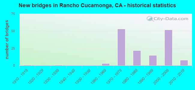
- New bridges - historical statistics
- 11910-1919
- 11930-1939
- 31960-1969
- 531970-1979
- 221980-1989
- 151990-1999
- 522000-2009
- 82010-2019
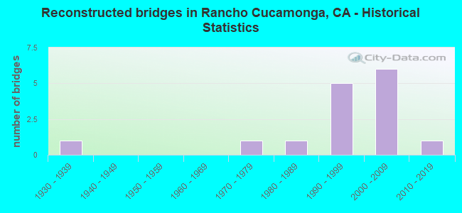
- Reconstructed bridges - Historical Statistics
- 11930-1939
- 01940-1949
- 01950-1959
- 01960-1969
- 11970-1979
- 11980-1989
- 51990-1999
- 62000-2009
- 12010-2019
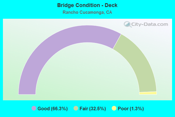
- Bridge Condition - Deck
- 66.3%Good
- 32.5%Fair
- 1.3%Poor
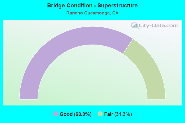
- Bridge Condition - Superstructure
- 68.8%Good
- 31.3%Fair
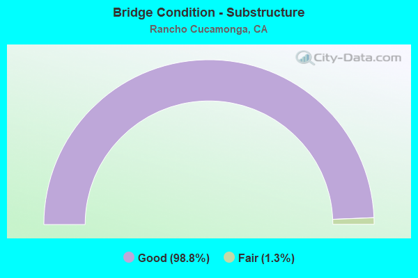
- Bridge Condition - Substructure
- 98.8%Good
- 1.3%Fair
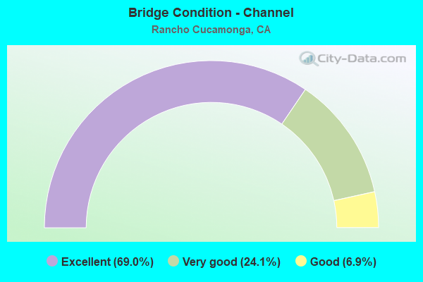
- Bridge Condition - Channel
- 69.0%Excellent
- 24.1%Very good
- 6.9%Good
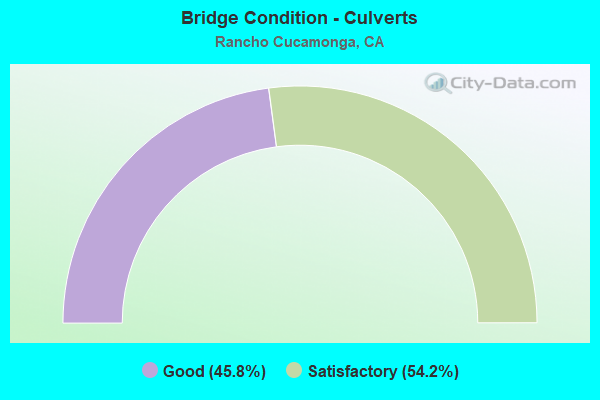
- Bridge Condition - Culverts
- 45.8%Good
- 54.2%Satisfactory
Find on map >> Show street view
Structure Number: 54 1157R, Location: 08-SBD-210-8.66-RCUC (Lat: 34.136333, Lng: -117.545586), Route carried "under" structure: City street , Year Built: 2001, Structure Length: 0. m, Average Daily Traffic: 1,400 (year 2014), Truck Traffic: 5%, Features Intersected: ROCHESTER AVENUE, Facility Carried by Structure: STATE ROUTE 210 EB
Minimum Vertical Clearance: 6.07m (19.91ft), Kilometerpoint: 0.000, Lanes on structure: 4, Lanes under structure: 4, Material/Design: Prestressed concrete, Design/Construction: Box Beam or Girders - Multiple, Length of Maximum Span: 36.2m (118.8ft)
Find on map >> Show street view
Structure Number: 54 1158L, Location: 08-SBD-210-9.14-RCUC (Lat: 34.136547, Lng: -117.537125), Route carried "under" structure: City street , Year Built: 2001, Structure Length: 0. m, Average Daily Traffic: 8,000 (year 2014), Truck Traffic: 5%, Features Intersected: DAY CREEK BLVD, Facility Carried by Structure: STATE ROUTE 210 WB
Minimum Vertical Clearance: 5.69m (18.67ft), Kilometerpoint: 0.000, Lanes on structure: 4, Lanes under structure: 8, Material/Design: Prestressed concrete continuous, Design/Construction: Box Beam or Girders - Multiple, Length of Maximum Span: 37.7m (123.7ft)
Find on map >> Show street view
Structure Number: 54 1158R, Location: 08-SBD-210-9.14-RCUC (Lat: 34.136281, Lng: -117.537136), Route carried "under" structure: City street , Year Built: 2001, Structure Length: 0. m, Average Daily Traffic: 8,000 (year 2014), Truck Traffic: 5%, Features Intersected: DAY CREEK BLVD, Facility Carried by Structure: STATE ROUTE 210 EB
Minimum Vertical Clearance: 6.22m (20.41ft), Kilometerpoint: 0.000, Lanes on structure: 4, Lanes under structure: 8, Material/Design: Prestressed concrete continuous, Design/Construction: Box Beam or Girders - Multiple, Length of Maximum Span: 37.7m (123.7ft)
Find on map >> Show street view
Structure Number: 54 1289K, Location: 08-SBD-015-6.74-RCUC (Lat: 34.121228, Lng: -117.515203), Route carried "under" structure: City street R060, Year Built: 2016, Structure Length: 0. m, Average Daily Traffic: 31,000 (year 2012), Truck Traffic: 3%, Features Intersected: BASELINE ROAD, Facility Carried by Structure: S15 ON RAMP
Minimum Vertical Clearance: 4.65m (15.26ft), Kilometerpoint: 0.000, Lanes on structure: 2, Lanes under structure: 10, Material/Design: Concrete continuous, Design/Construction: Stringer/Multi-beam, Length of Maximum Span: 36.6m (120.1ft)
Find on map >> Show street view
Structure Number: 54 1290K, Location: 08-SBD-015-6.85-RCUC (Lat: 34.122697, Lng: -117.514806), Route carried "under" structure: City street , Year Built: 2016, Structure Length: 0. m, Average Daily Traffic: 10,000 (year 2012), Truck Traffic: 2%, Features Intersected: EAST AVENUE, Facility Carried by Structure: S15 OFF RAMP
Minimum Vertical Clearance: 5.13m (16.83ft), Kilometerpoint: 0.000, Lanes on structure: 2, Lanes under structure: 4, Material/Design: Concrete continuous, Design/Construction: Box Beam or Girders - Multiple, Length of Maximum Span: 21.6m (70.9ft)
Find on map >> Show street view
Structure Number: 54C0608, Location: 0.3 MI N OF RTE 66 (Lat: 34.110269, Lng: -117.612219), Route carried "under" structure: City street , Year Built: 1966, Structure Length: 0. m, Average Daily Traffic: 28,800 (year 2007), Truck Traffic: 1%, Features Intersected: CARNELIAN STREET, Facility Carried by Structure: PEDESTRIAN ACCESS
Minimum Vertical Clearance: 4.50m (14.76ft), Kilometerpoint: 0.080, Lanes under structure: 4, Material/Design: Concrete, Design/Construction: Box Beam or Girders - Multiple, Length of Maximum Span: 11.9m (39.0ft)
Find on map >> Show street view
Structure Number: 54C0732, Location: 0.21 MI S/O JERSEY BLVD (Lat: 34.091922, Lng: -117.557811), Route carried "under" structure: City street , Year Built: 2011, Structure Length: 0. m, Average Daily Traffic: 17,000 (year 2012), Truck Traffic: 7%, Features Intersected: MILIKEN AVENUE, Facility Carried by Structure: BNSF & METROLINK
Minimum Vertical Clearance: 4.85m (15.91ft), Kilometerpoint: 0.050, Lanes under structure: 6, Material/Design: Prestressed concrete, Design/Construction: Box Beam or Girders - Multiple, Length of Maximum Span: 23.9m (78.4ft)
Find on map >> Show street view
Structure Number: 54C0733, Location: 0.2 MI S/O JERSEY BLVD (Lat: 34.092369, Lng: -117.557578), Route carried "under" structure: City street , Year Built: 2011, Structure Length: 0. m, Average Daily Traffic: 17,000 (year 2012), Truck Traffic: 7%, Features Intersected: MILIKEN AVENUE, Facility Carried by Structure: BNSF & METROLINK
Minimum Vertical Clearance: 5.11m (16.77ft), Kilometerpoint: 0.060, Lanes under structure: 6, Material/Design: Prestressed concrete, Design/Construction: Box Beam or Girders - Multiple, Length of Maximum Span: 20.7m (67.9ft)
Find on map >> Show street view
Structure Number: 54C0735, Location: 0.2 MI S/O JERSEY BLVD (Lat: 34.091844, Lng: -117.576111), Route carried "under" structure: City street , Year Built: 2010, Structure Length: 0. m, Average Daily Traffic: 24,500 (year 2012), Truck Traffic: 3%, Features Intersected: HAVEN AVENUE, Facility Carried by Structure: BNSF & METROLINK
Minimum Vertical Clearance: 4.85m (15.91ft), Kilometerpoint: 0.040, Lanes under structure: 6, Material/Design: Prestressed concrete, Design/Construction: Box Beam or Girders - Multiple, Length of Maximum Span: 16.1m (52.8ft)
Find on map >> Show street view
Structure Number: 54C0771, Location: PACIFIC TRAIL AT FOOTHILL (Lat: 34.104764, Lng: -117.620569), Route carried "under" structure: City street , Year Built: 2013, Structure Length: 0. m, Average Daily Traffic: 23,633 (year 2013), Truck Traffic: 3%, Features Intersected: FOOTHILL BLVD, Facility Carried by Structure: FOOTHILL BLVD POC
Minimum Vertical Clearance: 5.18m (16.99ft), Kilometerpoint: 0.100, Lanes under structure: 4, Material/Design: Prestressed concrete, Design/Construction: Box Beam or Girders - Multiple, Length of Maximum Span: 45.8m (150.3ft)