Bridge Statistics for Prichard, Alabama (AL)
Condition, Traffic, Stress, Structural Evaluation, Project Costs

- New bridges - historical statistics
- 91930-1939
- 41940-1949
- 201960-1969
- 151970-1979
- 251990-1999
- 112000-2009
- 12010-2019
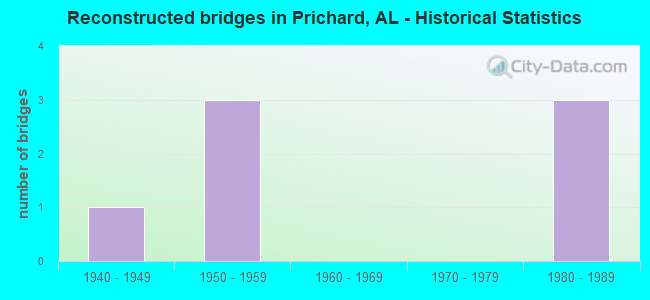
- Reconstructed bridges - Historical Statistics
- 11940-1949
- 31950-1959
- 01960-1969
- 01970-1979
- 31980-1989
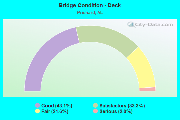
- Bridge Condition - Deck
- 43.1%Good
- 33.3%Satisfactory
- 21.6%Fair
- 2.0%Serious
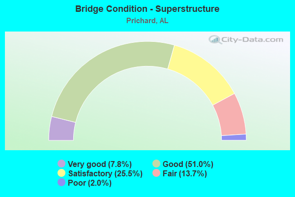
- Bridge Condition - Superstructure
- 7.8%Very good
- 51.0%Good
- 25.5%Satisfactory
- 13.7%Fair
- 2.0%Poor
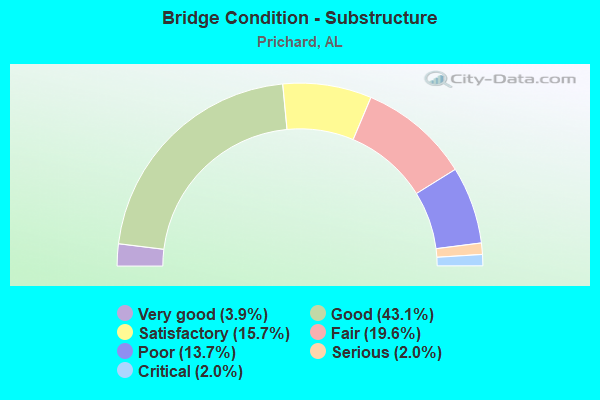
- Bridge Condition - Substructure
- 3.9%Very good
- 43.1%Good
- 15.7%Satisfactory
- 19.6%Fair
- 13.7%Poor
- 2.0%Serious
- 2.0%Critical
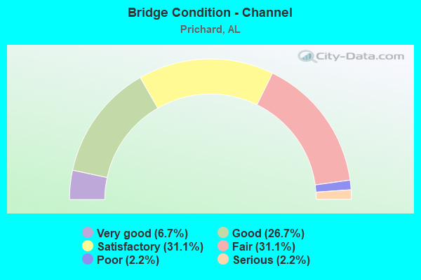
- Bridge Condition - Channel
- 6.7%Very good
- 26.7%Good
- 31.1%Satisfactory
- 31.1%Fair
- 2.2%Poor
- 2.2%Serious
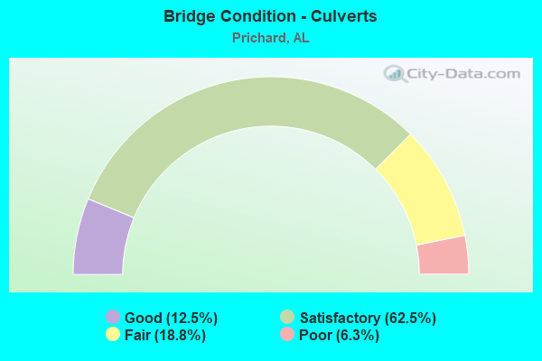
- Bridge Condition - Culverts
- 12.5%Good
- 62.5%Satisfactory
- 18.8%Fair
- 6.3%Poor
Find on map >> Show street view
Structure Number: 1554, Location: 0.7 MI S SR 158 (Lat: 30.792847, Lng: -88.152339), Route carried "on" structure: US 45, Year Built: 1992, Status: Open, Structure Length: 4.15m (13.62ft), Average Daily Traffic: 5,761 (year 2018), Truck Traffic: 5%, Average Future Daily Traffic: 8,642 (year 2038), Design Load: HS 20, Features Intersected: SEABERRY CREEK
Minimum Vertical Clearance: 30+ m (98+ ft), Kilometerpoint: 14.341, Lanes on structure: 2, Base Highway Network: Yes, Owner: State Highway Agency, Approaching Roadway Width: 9.8m (32.2ft), Material/Design: Prestressed concrete continuous, Design/Construction: Stringer/Multi-beam, Number Of Spans In Main Unit: 4, Length of Maximum Span: 10.7m (35.1ft), Curb-To-Curb Width: 13.4m (44.0ft), Out-to-Out Width: 14.2m (46.6ft)
Condition: Deck: Satisfactory, Superstructure: Good, Substructure: Good, Channel: Satisfactory, Operating Rating: 52.8 metric tons, Method Used To Determine Operating Rating: Load Factor (LF), Inventory Rating: 31.7 metric tons, Method Used To Determine Inventory Rating: Load Factor (LF), Structural Evaluation: Better than present minimum criteria, Deck Geometry: Equal to present minimum criteria, Waterway Adequacy: Equal to present minimum criteria, Approach Roadway Alignment: Better than present minimum criteria, Length Of Structure Improvement: 5.11m (16.77ft), Designated Inspection Frequency: Every 24 months, Inspection Date: July 2020, Bridge Improvement Cost: $1,612,000, Roadway Improvement Cost: $161,000, Total Project Cost: $1,773,000 ( Estimate for 2022), Deck Structure Type: Concrete Cast-file-Place
Find on map >> Show street view
Structure Number: 15541, Location: 0.3 MI S SR 158 (Lat: 30.799217, Lng: -88.151028), Route carried "on" structure: US 45, Year Built: 1992, Status: Open, Structure Length: 5.12m (16.80ft), Average Daily Traffic: 5,761 (year 2018), Truck Traffic: 5%, Average Future Daily Traffic: 8,642 (year 2038), Design Load: HS 20, Features Intersected: OUTLAW STREAM
Minimum Vertical Clearance: 30+ m (98+ ft), Kilometerpoint: 15.055, Lanes on structure: 2, Base Highway Network: Yes, Owner: State Highway Agency, Approaching Roadway Width: 10.4m (34.1ft), Skew: 4 degrees, Material/Design: Prestressed concrete continuous, Design/Construction: Stringer/Multi-beam, Number Of Spans In Main Unit: 5, Length of Maximum Span: 10.4m (34.1ft), Curb-To-Curb Width: 13.4m (44.0ft), Out-to-Out Width: 14.3m (46.9ft)
Condition: Deck: Good, Superstructure: Good, Substructure: Good, Channel: Fair, Operating Rating: 52.8 metric tons, Method Used To Determine Operating Rating: Load Factor (LF), Inventory Rating: 31.7 metric tons, Method Used To Determine Inventory Rating: Load Factor (LF), Structural Evaluation: Better than present minimum criteria, Deck Geometry: Equal to present minimum criteria, Waterway Adequacy: Equal to present minimum criteria, Approach Roadway Alignment: Better than present minimum criteria, Length Of Structure Improvement: 6.14m (20.14ft), Designated Inspection Frequency: Every 24 months, Underwater Inspection Frequency: Every 24 months, Inspection Date: July 2020, Underwater Inspection Date: October 2020, Bridge Improvement Cost: $1,937,000, Roadway Improvement Cost: $194,000, Total Project Cost: $2,131,000 ( Estimate for 2022), Deck Structure Type: Concrete Cast-file-Place
Find on map >> Show street view
Structure Number: 15575, Location: I-165 @ BAY BRIDGE RD (Lat: 30.727044, Lng: -88.072597), Route carried "on" structure: Ramp Interstate 165, Year Built: 1993, Status: Open, Structure Length: 25.18m (82.61ft), Average Daily Traffic: 2,679 (year 2019), Truck Traffic: 14%, Average Future Daily Traffic: 4,019 (year 2039), Design Load: HS 20, Features Intersected: BAY BRIDGE RD
Minimum Vertical Clearance: 30+ m (98+ ft), Kilometerpoint: 4.183, Lanes on structure: 2, Owner: State Highway Agency, Approaching Roadway Width: 12.2m (40.0ft), Material/Design: Prestressed concrete continuous, Design/Construction: Stringer/Multi-beam, Number Of Spans In Main Unit: 7, Number Of Approach Spans: 4, Length of Maximum Span: 23.2m (76.1ft), Curb-To-Curb Width: 11.6m (38.1ft), Out-to-Out Width: 12.5m (41.0ft)
Condition: Deck: Good, Superstructure: Good, Substructure: Good, Operating Rating: 42.0 metric tons, Method Used To Determine Operating Rating: Load Factor (LF), Inventory Rating: 28.2 metric tons, Method Used To Determine Inventory Rating: Load Factor (LF), Structural Evaluation: Better than present minimum criteria, Deck Geometry: Superior to present desirable criteria, Approach Roadway Alignment: Better than present minimum criteria, Length Of Structure Improvement: 25.18m (82.61ft), Designated Inspection Frequency: Every 24 months, Inspection Date: September 2020, Bridge Improvement Cost: $7,078,000, Roadway Improvement Cost: $708,000, Total Project Cost: $7,786,000 ( Estimate for 2022), Deck Structure Type: Concrete Cast-file-Place
Find on map >> Show street view
Structure Number: 15576, Location: I-165 @ BAY BRIDGE RD (Lat: 30.727672, Lng: -88.071997), Route carried "on" structure: Ramp Interstate 165, Year Built: 1993, Status: Open, Structure Length: 22.77m (74.70ft), Average Daily Traffic: 2,689 (year 2019), Truck Traffic: 12%, Average Future Daily Traffic: 4,033 (year 2039), Design Load: HS 20, Features Intersected: BAY BRIDGE RD
Minimum Vertical Clearance: 30+ m (98+ ft), Kilometerpoint: 4.379, Lanes on structure: 2, Owner: State Highway Agency, Approaching Roadway Width: 11.6m (38.1ft), Material/Design: Prestressed concrete continuous, Design/Construction: Stringer/Multi-beam, Number Of Spans In Main Unit: 7, Number Of Approach Spans: 3, Length of Maximum Span: 23.2m (76.1ft), Curb-To-Curb Width: 11.6m (38.1ft), Out-to-Out Width: 12.5m (41.0ft)
Condition: Deck: Satisfactory, Superstructure: Satisfactory, Substructure: Good, Operating Rating: 40.9 metric tons, Method Used To Determine Operating Rating: Load Factor (LF), Inventory Rating: 24.2 metric tons, Method Used To Determine Inventory Rating: Load Factor (LF), Structural Evaluation: Somewhat better than minimum adequacy, Deck Geometry: Superior to present desirable criteria, Approach Roadway Alignment: Equal to present minimum criteria, Length Of Structure Improvement: 22.77m (74.70ft), Designated Inspection Frequency: Every 24 months, Inspection Date: September 2020, Bridge Improvement Cost: $6,401,000, Roadway Improvement Cost: $640,000, Total Project Cost: $7,041,000 ( Estimate for 2022), Deck Structure Type: Concrete Cast-file-Place
Find on map >> Show street view
Structure Number: 15577, Location: I-165 @ BAY BRIDGE RD (Lat: 30.731256, Lng: -88.077336), Route carried "on" structure: Ramp Interstate 165, Year Built: 1993, Status: Open, Structure Length: 14.63m (48.00ft), Average Daily Traffic: 9,635 (year 2019), Truck Traffic: 9%, Average Future Daily Traffic: 14,453 (year 2039), Design Load: HS 20, Features Intersected: BAY BRIDGE RD
Minimum Vertical Clearance: 30+ m (98+ ft), Kilometerpoint: 3.536, Lanes on structure: 1, Owner: State Highway Agency, Approaching Roadway Width: 9.1m (29.9ft), Material/Design: Prestressed concrete continuous, Design/Construction: Stringer/Multi-beam, Number Of Spans In Main Unit: 5, Number Of Approach Spans: 4, Length of Maximum Span: 24.4m (80.1ft), Curb-To-Curb Width: 7.6m (24.9ft), Out-to-Out Width: 8.5m (27.9ft)
Condition: Deck: Fair, Superstructure: Good, Substructure: Good, Operating Rating: 52.1 metric tons, Method Used To Determine Operating Rating: Load Factor (LF), Inventory Rating: 33.8 metric tons, Method Used To Determine Inventory Rating: Load Factor (LF), Structural Evaluation: Better than present minimum criteria, Deck Geometry: Better than present minimum criteria, Approach Roadway Alignment: Better than present minimum criteria, Length Of Structure Improvement: 15.41m (50.56ft), Designated Inspection Frequency: Every 24 months, Inspection Date: September 2020, Bridge Improvement Cost: $2,854,000, Roadway Improvement Cost: $285,000, Total Project Cost: $3,139,000 ( Estimate for 2022), Deck Structure Type: Concrete Cast-file-Place
Find on map >> Show street view
Structure Number: 15578, Location: I165 @ BAY BRIDGE RD (Lat: 30.731103, Lng: -88.076422), Route carried "on" structure: Ramp Interstate 165, Year Built: 1993, Status: Open, Structure Length: 9.91m (32.51ft), Average Daily Traffic: 8,860 (year 2019), Truck Traffic: 11%, Average Future Daily Traffic: 13,280 (year 2039), Design Load: HS 20, Features Intersected: BAY BRIDGE RD
Minimum Vertical Clearance: 30+ m (98+ ft), Kilometerpoint: 3.664, Lanes on structure: 1, Owner: State Highway Agency, Approaching Roadway Width: 9.1m (29.9ft), Material/Design: Prestressed concrete continuous, Design/Construction: Stringer/Multi-beam, Number Of Spans In Main Unit: 5, Length of Maximum Span: 22.9m (75.1ft), Curb-To-Curb Width: 7.6m (24.9ft), Out-to-Out Width: 8.5m (27.9ft)
Condition: Deck: Satisfactory, Superstructure: Good, Substructure: Good, Operating Rating: 46.6 metric tons, Method Used To Determine Operating Rating: Load Factor (LF), Inventory Rating: 27.6 metric tons, Method Used To Determine Inventory Rating: Load Factor (LF), Structural Evaluation: Equal to present minimum criteria, Deck Geometry: Better than present minimum criteria, Approach Roadway Alignment: Somewhat better than minimum adequacy, Length Of Structure Improvement: 10.84m (35.56ft), Designated Inspection Frequency: Every 24 months, Inspection Date: September 2020, Bridge Improvement Cost: $2,007,000, Roadway Improvement Cost: $201,000, Total Project Cost: $2,208,000 ( Estimate for 2022), Deck Structure Type: Concrete Cast-file-Place
Find on map >> Show street view
Structure Number: 15579, Location: I165 @ WILSON AVENUE (Lat: 30.736906, Lng: -88.084144), Route carried "on" structure: Ramp Interstate 165, Year Built: 1993, Status: Open, Structure Length: 9.17m (30.09ft), Average Daily Traffic: 1,035 (year 2019), Truck Traffic: 2%, Average Future Daily Traffic: 1,552 (year 2039), Design Load: HS 20, Features Intersected: WILSON AVENUE
Minimum Vertical Clearance: 30+ m (98+ ft), Kilometerpoint: 2.643, Lanes on structure: 1, Owner: State Highway Agency, Approaching Roadway Width: 9.1m (29.9ft), Material/Design: Prestressed concrete continuous, Design/Construction: Stringer/Multi-beam, Number Of Spans In Main Unit: 4, Length of Maximum Span: 22.9m (75.1ft), Curb-To-Curb Width: 7.6m (24.9ft), Out-to-Out Width: 8.4m (27.6ft)
Condition: Deck: Good, Superstructure: Good, Substructure: Good, Operating Rating: 77.2 metric tons, Method Used To Determine Operating Rating: Load Factor (LF), Inventory Rating: 41.9 metric tons, Method Used To Determine Inventory Rating: Load Factor (LF), Structural Evaluation: Better than present minimum criteria, Deck Geometry: Better than present minimum criteria, Approach Roadway Alignment: Equal to present desirable criteria, Length Of Structure Improvement: 10.14m (33.27ft), Designated Inspection Frequency: Every 24 months, Inspection Date: September 2020, Bridge Improvement Cost: $1,877,000, Roadway Improvement Cost: $188,000, Total Project Cost: $2,065,000 ( Estimate for 2022), Deck Structure Type: Concrete Cast-file-Place
Find on map >> Show street view
Structure Number: 1558, Location: I165 @ WILSON AVE (Lat: 30.737581, Lng: -88.084097), Route carried "on" structure: Ramp Interstate 165, Year Built: 1993, Status: Open, Structure Length: 16.03m (52.59ft), Average Daily Traffic: 1,228 (year 2019), Truck Traffic: 9%, Average Future Daily Traffic: 1,842 (year 2039), Design Load: HS 20, Features Intersected: WILSON AVE
Minimum Vertical Clearance: 30+ m (98+ ft), Kilometerpoint: 2.721, Lanes on structure: 1, Owner: State Highway Agency, Approaching Roadway Width: 9.1m (29.9ft), Material/Design: Prestressed concrete continuous, Design/Construction: Stringer/Multi-beam, Number Of Spans In Main Unit: 6, Number Of Approach Spans: 1, Length of Maximum Span: 22.9m (75.1ft), Curb-To-Curb Width: 7.6m (24.9ft), Out-to-Out Width: 8.4m (27.6ft)
Condition: Deck: Satisfactory, Superstructure: Good, Substructure: Good, Operating Rating: 49.0 metric tons, Method Used To Determine Operating Rating: Load Factor (LF), Inventory Rating: 28.9 metric tons, Method Used To Determine Inventory Rating: Load Factor (LF), Structural Evaluation: Better than present minimum criteria, Deck Geometry: Better than present minimum criteria, Approach Roadway Alignment: Equal to present desirable criteria, Length Of Structure Improvement: 16.78m (55.05ft), Designated Inspection Frequency: Every 24 months, Inspection Date: September 2020, Bridge Improvement Cost: $3,107,000, Roadway Improvement Cost: $311,000, Total Project Cost: $3,418,000 ( Estimate for 2022), Deck Structure Type: Concrete Cast-file-Place
Find on map >> Show street view
Structure Number: 15581, Location: I165 @ PRICE AVE (Lat: 30.743478, Lng: -88.089856), Route carried "on" structure: Ramp Interstate 165, Year Built: 1993, Status: Open, Structure Length: 30.11m (98.79ft), Average Daily Traffic: 1,443 (year 2019), Truck Traffic: 8%, Average Future Daily Traffic: 2,164 (year 2039), Design Load: HS 20, Features Intersected: PRICE AVE
Minimum Vertical Clearance: 30+ m (98+ ft), Kilometerpoint: 1.717, Lanes on structure: 1, Lanes under structure: 6, Owner: State Highway Agency, Approaching Roadway Width: 9.1m (29.9ft), Material/Design: Steel, Design/Construction: Stringer/Multi-beam, Number Of Spans In Main Unit: 3, Number Of Approach Spans: 13, Length of Maximum Span: 51.5m (169.0ft), Curb-To-Curb Width: 7.6m (24.9ft), Out-to-Out Width: 8.4m (27.6ft)
Condition: Deck: Good, Superstructure: Very good, Substructure: Good, Operating Rating: 60.3 metric tons, Method Used To Determine Operating Rating: Load Factor (LF), Inventory Rating: 35.8 metric tons, Method Used To Determine Inventory Rating: Load Factor (LF), Structural Evaluation: Better than present minimum criteria, Deck Geometry: Better than present minimum criteria, Underclear: High priority of corrective action, Approach Roadway Alignment: Equal to present desirable criteria, Length Of Structure Improvement: 30.11m (98.79ft), Designated Inspection Frequency: Every 24 months, Inspection Date: September 2020, Bridge Improvement Cost: $5,575,000, Roadway Improvement Cost: $558,000, Total Project Cost: $6,133,000 ( Estimate for 2022), Deck Structure Type: Concrete Cast-file-Place
Find on map >> Show street view
Structure Number: 15582, Location: I165 @ PRICE AVENUE (Lat: 30.742408, Lng: -88.089033), Route carried "on" structure: Ramp Interstate 165, Year Built: 1993, Status: Open, Structure Length: 14.45m (47.41ft), Average Daily Traffic: 2,314 (year 2019), Truck Traffic: 4%, Average Future Daily Traffic: 3,471 (year 2039), Design Load: HS 20, Features Intersected: PRICE AVENUE
Minimum Vertical Clearance: 30+ m (98+ ft), Kilometerpoint: 1.999, Lanes on structure: 1, Owner: State Highway Agency, Approaching Roadway Width: 9.1m (29.9ft), Material/Design: Prestressed concrete continuous, Design/Construction: Stringer/Multi-beam, Number Of Spans In Main Unit: 6, Number Of Approach Spans: 1, Length of Maximum Span: 21.3m (69.9ft), Curb-To-Curb Width: 7.6m (24.9ft), Out-to-Out Width: 8.4m (27.6ft)
Condition: Deck: Satisfactory, Superstructure: Good, Substructure: Good, Operating Rating: 62.4 metric tons, Method Used To Determine Operating Rating: Load Factor (LF), Inventory Rating: 37.4 metric tons, Method Used To Determine Inventory Rating: Load Factor (LF), Structural Evaluation: Better than present minimum criteria, Deck Geometry: Better than present minimum criteria, Approach Roadway Alignment: Better than present minimum criteria, Length Of Structure Improvement: 15.23m (49.97ft), Designated Inspection Frequency: Every 24 months, Inspection Date: September 2020, Bridge Improvement Cost: $2,820,000, Roadway Improvement Cost: $282,000, Total Project Cost: $3,102,000 ( Estimate for 2022), Deck Structure Type: Concrete Cast-file-Place
Find on map >> Show street view
Structure Number: 15583, Location: I165 @ WHISTLER ST (Lat: 30.747639, Lng: -88.089997), Route carried "on" structure: Ramp Interstate 165, Year Built: 1993, Status: Open, Structure Length: 11.73m (38.48ft), Average Daily Traffic: 3,021 (year 2019), Truck Traffic: 9%, Average Future Daily Traffic: 4,532 (year 2039), Design Load: HS 20, Features Intersected: WHISTLER ST
Minimum Vertical Clearance: 30+ m (98+ ft), Kilometerpoint: 1.255, Lanes on structure: 1, Owner: State Highway Agency, Approaching Roadway Width: 9.1m (29.9ft), Material/Design: Prestressed concrete, Design/Construction: Stringer/Multi-beam, Number Of Spans In Main Unit: 6, Length of Maximum Span: 22.9m (75.1ft), Curb-To-Curb Width: 7.6m (24.9ft), Out-to-Out Width: 8.4m (27.6ft)
Condition: Deck: Good, Superstructure: Very good, Substructure: Good, Operating Rating: 49.6 metric tons, Method Used To Determine Operating Rating: Load Factor (LF), Inventory Rating: 34.3 metric tons, Method Used To Determine Inventory Rating: Load Factor (LF), Structural Evaluation: Better than present minimum criteria, Deck Geometry: Better than present minimum criteria, Approach Roadway Alignment: Equal to present desirable criteria, Length Of Structure Improvement: 12.60m (41.34ft), Designated Inspection Frequency: Every 24 months, Inspection Date: September 2020, Bridge Improvement Cost: $2,332,000, Roadway Improvement Cost: $233,000, Total Project Cost: $2,565,000 ( Estimate for 2022), Deck Structure Type: Concrete Cast-file-Place
Find on map >> Show street view
Structure Number: 15584, Location: I-165 @ WHISTLER ST (Lat: 30.747503, Lng: -88.089411), Route carried "on" structure: Ramp Interstate 165, Year Built: 1993, Status: Open, Structure Length: 19.51m (64.01ft), Average Daily Traffic: 3,310 (year 2019), Truck Traffic: 2%, Average Future Daily Traffic: 4,965 (year 2039), Design Load: HS 20, Features Intersected: WHISTLER ST
Minimum Vertical Clearance: 30+ m (98+ ft), Kilometerpoint: 1.453, Lanes on structure: 1, Owner: State Highway Agency, Approaching Roadway Width: 9.1m (29.9ft), Material/Design: Prestressed concrete continuous, Design/Construction: Stringer/Multi-beam, Number Of Spans In Main Unit: 9, Length of Maximum Span: 22.9m (75.1ft), Curb-To-Curb Width: 7.6m (24.9ft), Out-to-Out Width: 8.4m (27.6ft)
Condition: Deck: Good, Superstructure: Good, Substructure: Good, Operating Rating: 55.4 metric tons, Method Used To Determine Operating Rating: Load Factor (LF), Inventory Rating: 32.5 metric tons, Method Used To Determine Inventory Rating: Load Factor (LF), Structural Evaluation: Better than present minimum criteria, Deck Geometry: Better than present minimum criteria, Approach Roadway Alignment: Equal to present desirable criteria, Length Of Structure Improvement: 20.08m (65.88ft), Designated Inspection Frequency: Every 24 months, Inspection Date: September 2020, Bridge Improvement Cost: $3,717,000, Roadway Improvement Cost: $372,000, Total Project Cost: $4,089,000 ( Estimate for 2022), Deck Structure Type: Concrete Cast-file-Place
Find on map >> Show street view
Structure Number: 15585, Location: I-165 * I-65 INTERCHANGE (Lat: 30.751853, Lng: -88.092994), Route carried "on" structure: Ramp Interstate 165, Year Built: 1993, Status: Open, Structure Length: 4.60m (15.09ft), Average Daily Traffic: 11,815 (year 2019), Truck Traffic: 12%, Average Future Daily Traffic: 17,723 (year 2039), Design Load: HS 20, Features Intersected: I-65
Minimum Vertical Clearance: 30+ m (98+ ft), Kilometerpoint: 0.000, Lanes on structure: 2, Owner: State Highway Agency, Approaching Roadway Width: 12.2m (40.0ft), Material/Design: Prestressed concrete continuous, Design/Construction: Stringer/Multi-beam, Number Of Spans In Main Unit: 2, Length of Maximum Span: 23.2m (76.1ft), Curb-To-Curb Width: 12.2m (40.0ft), Out-to-Out Width: 13.0m (42.7ft)
Condition: Deck: Satisfactory, Superstructure: Good, Substructure: Good, Operating Rating: 36.6 metric tons, Method Used To Determine Operating Rating: Load Factor (LF), Inventory Rating: 22.0 metric tons, Method Used To Determine Inventory Rating: Load Factor (LF), Structural Evaluation: Somewhat better than minimum adequacy, Deck Geometry: Superior to present desirable criteria, Approach Roadway Alignment: Better than present minimum criteria, Length Of Structure Improvement: 5.60m (18.37ft), Designated Inspection Frequency: Every 24 months, Inspection Date: September 2020, Bridge Improvement Cost: $1,613,000, Roadway Improvement Cost: $161,000, Total Project Cost: $1,774,000 ( Estimate for 2022), Deck Structure Type: Concrete Cast-file-Place
Find on map >> Show street view
Structure Number: 15586, Location: I-165 * I-65 INTERCHANGE (Lat: 30.757283, Lng: -88.093281), Route carried "on" structure: Ramp Interstate 165, Year Built: 1993, Status: Open, Structure Length: 69.19m (227.00ft), Average Daily Traffic: 11,892 (year 2019), Truck Traffic: 10%, Average Future Daily Traffic: 17,838 (year 2039), Design Load: HS 20, Features Intersected: I-65 * GUM TREE BRANCH
Minimum Vertical Clearance: 5.70m (18.70ft), Kilometerpoint: 0.000, Lanes on structure: 2, Lanes under structure: 6, Owner: State Highway Agency, Approaching Roadway Width: 13.1m (43.0ft), Material/Design: Steel continuous, Design/Construction: Stringer/Multi-beam, Number Of Spans In Main Unit: 4, Number Of Approach Spans: 24, Length of Maximum Span: 48.8m (160.1ft), Curb-To-Curb Width: 12.2m (40.0ft), Out-to-Out Width: 13.0m (42.7ft)
Condition: Deck: Good, Superstructure: Satisfactory, Substructure: Good, Channel: Satisfactory, Operating Rating: 39.0 metric tons, Method Used To Determine Operating Rating: Load Factor (LF), Inventory Rating: 23.4 metric tons, Method Used To Determine Inventory Rating: Load Factor (LF), Structural Evaluation: Somewhat better than minimum adequacy, Deck Geometry: Superior to present desirable criteria, Underclear: Equal to present minimum criteria, Waterway Adequacy: Equal to present desirable criteria, Approach Roadway Alignment: Equal to present desirable criteria, Length Of Structure Improvement: 69.19m (227.00ft), Designated Inspection Frequency: Every 24 months, Inspection Date: November 2020, Bridge Improvement Cost: $19,926,000, Roadway Improvement Cost: $1,993,000, Total Project Cost: $21,919,000 ( Estimate for 2022), Deck Structure Type: Concrete Cast-file-Place
Find on map >> Show street view
Structure Number: 15587, Location: I-165 * I-65 INTERCHANGE (Lat: 30.750458, Lng: -88.097461), Route carried "on" structure: Ramp Interstate 165, Year Built: 1993, Status: Open, Structure Length: 61.51m (201.80ft), Average Daily Traffic: 11,993 (year 2019), Truck Traffic: 8%, Average Future Daily Traffic: 17,990 (year 2039), Design Load: HS 20, Features Intersected: I-65
Minimum Vertical Clearance: 30+ m (98+ ft), Kilometerpoint: 0.000, Lanes on structure: 2, Lanes under structure: 12, Owner: State Highway Agency, Approaching Roadway Width: 14.3m (46.9ft), Material/Design: Steel continuous, Design/Construction: Stringer/Multi-beam, Number Of Spans In Main Unit: 9, Number Of Approach Spans: 13, Length of Maximum Span: 54.9m (180.1ft), Curb-To-Curb Width: 13.4m (44.0ft), Out-to-Out Width: 14.2m (46.6ft)
Condition: Deck: Good, Superstructure: Satisfactory, Substructure: Good, Operating Rating: 38.6 metric tons, Method Used To Determine Operating Rating: Load Factor (LF), Inventory Rating: 23.1 metric tons, Method Used To Determine Inventory Rating: Load Factor (LF), Structural Evaluation: Somewhat better than minimum adequacy, Deck Geometry: Superior to present desirable criteria, Underclear: High priority of corrective action, Approach Roadway Alignment: Equal to present desirable criteria, Length Of Structure Improvement: 61.51m (201.80ft), Designated Inspection Frequency: Every 24 months, Inspection Date: November 2020, Bridge Improvement Cost: $19,401,000, Roadway Improvement Cost: $1,940,000, Total Project Cost: $21,341,000 ( Estimate for 2022), Deck Structure Type: Concrete Cast-file-Place
Find on map >> Show street view
Structure Number: 15588, Location: I-165 * I-65 INTERCHANGE (Lat: 30.755706, Lng: -88.093103), Route carried "on" structure: Ramp Interstate 165, Year Built: 1993, Status: Open, Structure Length: 41.48m (136.09ft), Average Daily Traffic: 12,271 (year 2019), Truck Traffic: 8%, Average Future Daily Traffic: 18,406 (year 2039), Design Load: HS 20, Features Intersected: I-65 * GUM TREE BRANCH
Minimum Vertical Clearance: 30+ m (98+ ft), Kilometerpoint: 0.000, Lanes on structure: 2, Owner: State Highway Agency, Approaching Roadway Width: 13.1m (43.0ft), Material/Design: Prestressed concrete continuous, Design/Construction: Stringer/Multi-beam, Number Of Spans In Main Unit: 18, Length of Maximum Span: 23.5m (77.1ft), Curb-To-Curb Width: 12.2m (40.0ft), Out-to-Out Width: 13.0m (42.7ft)
Condition: Deck: Good, Superstructure: Satisfactory, Substructure: Good, Channel: Good, Operating Rating: 36.4 metric tons, Method Used To Determine Operating Rating: Load Factor (LF), Inventory Rating: 21.5 metric tons, Method Used To Determine Inventory Rating: Load Factor (LF), Structural Evaluation: Somewhat better than minimum adequacy, Deck Geometry: Superior to present desirable criteria, Waterway Adequacy: Equal to present desirable criteria, Approach Roadway Alignment: Equal to present desirable criteria, Length Of Structure Improvement: 41.48m (136.09ft), Designated Inspection Frequency: Every 24 months, Inspection Date: September 2020, Bridge Improvement Cost: $11,947,000, Roadway Improvement Cost: $1,195,000, Total Project Cost: $13,142,000 ( Estimate for 2022), Deck Structure Type: Concrete Cast-file-Place
Find on map >> Show street view
Structure Number: 1572, Location: BETW. WILSON * PRICE AVE (Lat: 30.736997, Lng: -88.084561), Route carried "on" structure: ServiceInterstate 165, Year Built: 1993, Status: Open, Structure Length: 1.37m (4.49ft), Average Daily Traffic: 2,360 (year 2017), Truck Traffic: 9%, Average Future Daily Traffic: 3,540 (year 2037), Design Load: HS 20, Features Intersected: TOULMINS SPRINGS BRANCH
Minimum Vertical Clearance: 30+ m (98+ ft), Kilometerpoint: 2.630, Lanes on structure: 5, Owner: State Highway Agency, Approaching Roadway Width: 28.0m (91.9ft), Skew: 13 degrees, Material/Design: Concrete, Design/Construction: Culvert, Number Of Spans In Main Unit: 3, Length of Maximum Span: 3.7m (12.1ft)
Condition: Channel: Good, Culverts: Satisfactory, Operating Rating: 88.9 metric tons, Method Used To Determine Operating Rating: Load Factor (LF), Inventory Rating: 63.9 metric tons, Method Used To Determine Inventory Rating: Load Factor (LF), Structural Evaluation: Equal to present minimum criteria, Waterway Adequacy: Equal to present desirable criteria, Approach Roadway Alignment: Equal to present desirable criteria, Length Of Structure Improvement: 2.05m (6.73ft), Designated Inspection Frequency: Every 24 months, Inspection Date: September 2020, Bridge Improvement Cost: $1,844,000, Roadway Improvement Cost: $184,000, Total Project Cost: $2,028,000 ( Estimate for 2022)
Find on map >> Show street view
Structure Number: 16435, Location: 0.4 MI W COCHRANE BRIDGE (Lat: 30.730564, Lng: -88.065694), Route carried "on" structure: Alternate US 90, Year Built: 1997, Status: Open, Structure Length: 45.72m (150.00ft), Average Daily Traffic: 22,509 (year 2019), Truck Traffic: 14%, Average Future Daily Traffic: 33,764 (year 2039), Design Load: HS 20, Features Intersected: US 43 * NORFOLK SOUTHERN
Minimum Vertical Clearance: 30+ m (98+ ft), Kilometerpoint: 51.122, Lanes on structure: 4, Lanes under structure: 4, Owner: State Highway Agency, Approaching Roadway Width: 23.6m (77.4ft), Skew: 30 degrees, Material/Design: Steel continuous, Design/Construction: Stringer/Multi-beam, Number Of Spans In Main Unit: 3, Number Of Approach Spans: 15, Length of Maximum Span: 48.2m (158.1ft), Curb or Sidewalk Widths: Left: 1.8m (5.9ft), Right: 0.0m, Curb-To-Curb Width: 24.3m (79.7ft), Out-to-Out Width: 27.9m (91.5ft)
Condition: Deck: Satisfactory, Superstructure: Good, Substructure: Good, Operating Rating: 43.1 metric tons, Method Used To Determine Operating Rating: Load Factor (LF), Inventory Rating: 25.7 metric tons, Method Used To Determine Inventory Rating: Load Factor (LF), Structural Evaluation: Equal to present minimum criteria, Deck Geometry: Superior to present desirable criteria, Underclear: Equal to present minimum criteria, Approach Roadway Alignment: Better than present minimum criteria, Length Of Structure Improvement: 45.72m (150.00ft), Designated Inspection Frequency: Every 24 months, Inspection Date: October 2020, Bridge Improvement Cost: $28,529,000, Roadway Improvement Cost: $2,853,000, Total Project Cost: $31,382,000 ( Estimate for 2022), Deck Structure Type: Concrete Cast-file-Place
Find on map >> Show street view
Structure Number: 1661, Location: 0.9 MI N US 45 (Lat: 30.750403, Lng: -88.096861), Route carried "on" structure: Interstate 65, Year Built: 1965, Year Reconstructed: 1992, Status: Open, Structure Length: 9.66m (31.69ft), Average Daily Traffic: 40,381 (year 2018), Truck Traffic: 11%, Average Future Daily Traffic: 60,572 (year 2038), Design Load: HS 20, Features Intersected: TURNER RD * WHISTLER AVE
Minimum Vertical Clearance: 30+ m (98+ ft), Kilometerpoint: 15.041, Lanes on structure: 5, Lanes under structure: 4, Owner: State Highway Agency, Approaching Roadway Width: 25.3m (83.0ft), Skew: 39 degrees, Material/Design: Steel, Design/Construction: Stringer/Multi-beam, Number Of Spans In Main Unit: 5, Length of Maximum Span: 21.6m (70.9ft), Curb-To-Curb Width: 25.5m (83.7ft), Out-to-Out Width: 26.3m (86.3ft)
Condition: Deck: Satisfactory, Superstructure: Satisfactory, Substructure: Satisfactory, Operating Rating: 55.6 metric tons, Method Used To Determine Operating Rating: Load Factor (LF), Inventory Rating: 33.3 metric tons, Method Used To Determine Inventory Rating: Load Factor (LF), Structural Evaluation: Equal to present minimum criteria, Deck Geometry: Better than present minimum criteria, Underclear: Meets minimum limits, Approach Roadway Alignment: Better than present minimum criteria, Length Of Structure Improvement: 10.61m (34.81ft), Designated Inspection Frequency: Every 24 months, Inspection Date: May 2020, Bridge Improvement Cost: $6,255,000, Roadway Improvement Cost: $626,000, Total Project Cost: $6,881,000 ( Estimate for 2022), Deck Structure Type: Concrete Cast-file-Place
Find on map >> Show street view
Structure Number: 17912, Location: 1.5 MI E JCT US 45 (Lat: 30.782481, Lng: -88.118817), Route carried "on" structure: State highway 213, Year Built: 2003, Status: Open, Structure Length: 25.39m (83.30ft), Average Daily Traffic: 4,135 (year 2018), Truck Traffic: 2%, Average Future Daily Traffic: 6,203 (year 2038), Design Load: HS 20, Features Intersected: CHICKASAW CREEK
Minimum Vertical Clearance: 30+ m (98+ ft), Kilometerpoint: 2.261, Lanes on structure: 2, Owner: State Highway Agency, Approaching Roadway Width: 7.9m (25.9ft), Material/Design: Prestressed concrete, Design/Construction: Stringer/Multi-beam, Number Of Spans In Main Unit: 7, Length of Maximum Span: 41.1m (134.8ft), Curb-To-Curb Width: 13.4m (44.0ft), Out-to-Out Width: 14.0m (45.9ft)
Condition: Deck: Good, Superstructure: Good, Substructure: Good, Channel: Satisfactory, Operating Rating: 74.5 metric tons, Method Used To Determine Operating Rating: Load Factor (LF), Inventory Rating: 33.0 metric tons, Method Used To Determine Inventory Rating: Load Factor (LF), Structural Evaluation: Better than present minimum criteria, Deck Geometry: Better than present minimum criteria, Waterway Adequacy: Better than present minimum criteria, Approach Roadway Alignment: Equal to present desirable criteria, Length Of Structure Improvement: 25.39m (83.30ft), Designated Inspection Frequency: Every 24 months, Underwater Inspection Frequency: Every 24 months, Inspection Date: August 2020, Underwater Inspection Date: June 2021, Bridge Improvement Cost: $8,008,000, Roadway Improvement Cost: $801,000, Total Project Cost: $8,809,000 ( Estimate for 2022), Deck Structure Type: Concrete Cast-file-Place
Find on map >> Show street view
Structure Number: 1856, Location: US 45 @ AL. 158 (Lat: 30.802722, Lng: -88.151222), Route carried "on" structure: State highway 158, Year Built: 2007, Status: Open, Structure Length: 7.54m (24.74ft), Average Daily Traffic: 11,989 (year 2019), Truck Traffic: 8%, Average Future Daily Traffic: 17,984 (year 2039), Design Load: HS 20, Features Intersected: US. 45
Minimum Vertical Clearance: 30+ m (98+ ft), Kilometerpoint: 7.129, Lanes on structure: 2, Lanes under structure: 3, Owner: State Highway Agency, Approaching Roadway Width: 10.4m (34.1ft), Skew: 10 degrees, Material/Design: Prestressed concrete, Design/Construction: Stringer/Multi-beam, Number Of Spans In Main Unit: 1, Number Of Approach Spans: 2, Length of Maximum Span: 38.1m (125.0ft), Curb-To-Curb Width: 12.2m (40.0ft), Out-to-Out Width: 13.0m (42.7ft)
Condition: Deck: Good, Superstructure: Very good, Substructure: Very good, Operating Rating: 74.8 metric tons, Method Used To Determine Operating Rating: Load Factor (LF), Inventory Rating: 39.7 metric tons, Method Used To Determine Inventory Rating: Load Factor (LF), Structural Evaluation: Equal to present desirable criteria, Deck Geometry: Better than present minimum criteria, Underclear: Better than present minimum criteria, Approach Roadway Alignment: Equal to present desirable criteria, Length Of Structure Improvement: 8.56m (28.08ft), Designated Inspection Frequency: Every 24 months, Inspection Date: April 2021, Bridge Improvement Cost: $2,466,000, Roadway Improvement Cost: $247,000, Total Project Cost: $2,713,000 ( Estimate for 2022), Deck Structure Type: Concrete Cast-file-Place
Find on map >> Show street view
Structure Number: 18561, Location: 0.50 MI E. US 45 (Lat: 30.802894, Lng: -88.144528), Route carried "on" structure: State highway 158, Year Built: 2006, Status: Open, Structure Length: 16.54m (54.27ft), Average Daily Traffic: 11,989 (year 2019), Truck Traffic: 8%, Average Future Daily Traffic: 17,984 (year 2039), Design Load: HS 20, Features Intersected: CHICKASAW CREEK
Minimum Vertical Clearance: 30+ m (98+ ft), Kilometerpoint: 7.757, Lanes on structure: 2, Owner: State Highway Agency, Approaching Roadway Width: 15.4m (50.5ft), Skew: 10 degrees, Material/Design: Prestressed concrete, Design/Construction: Stringer/Multi-beam, Number Of Spans In Main Unit: 5, Length of Maximum Span: 41.5m (136.2ft), Curb-To-Curb Width: 15.8m (51.8ft), Out-to-Out Width: 16.7m (54.8ft)
Condition: Deck: Good, Superstructure: Very good, Substructure: Very good, Channel: Fair, Operating Rating: 81.9 metric tons, Method Used To Determine Operating Rating: Load Factor (LF), Inventory Rating: 47.1 metric tons, Method Used To Determine Inventory Rating: Load Factor (LF), Structural Evaluation: Equal to present desirable criteria, Deck Geometry: Superior to present desirable criteria, Waterway Adequacy: Superior to present desirable criteria, Approach Roadway Alignment: Equal to present desirable criteria, Length Of Structure Improvement: 17.27m (56.66ft), Designated Inspection Frequency: Every 24 months, Inspection Date: April 2021, Bridge Improvement Cost: $6,396,000, Roadway Improvement Cost: $640,000, Total Project Cost: $7,036,000 ( Estimate for 2022), Deck Structure Type: Concrete Cast-file-Place
Find on map >> Show street view
Structure Number: 18562, Location: 1.7 MI. E US 45 (Lat: 30.802981, Lng: -88.125197), Route carried "on" structure: State highway 158, Year Built: 2005, Status: Open, Structure Length: 5.05m (16.57ft), Average Daily Traffic: 23,978 (year 2019), Truck Traffic: 8%, Average Future Daily Traffic: 35,967 (year 2039), Design Load: HS 20, Features Intersected: COLLEGE PARKWAY
Minimum Vertical Clearance: 30+ m (98+ ft), Kilometerpoint: 9.511, Lanes on structure: 2, Lanes under structure: 2, Owner: State Highway Agency, Approaching Roadway Width: 11.2m (36.7ft), Skew: 10 degrees, Material/Design: Prestressed concrete, Design/Construction: Stringer/Multi-beam, Number Of Spans In Main Unit: 2, Length of Maximum Span: 25.3m (83.0ft), Curb-To-Curb Width: 12.2m (40.0ft), Out-to-Out Width: 13.1m (43.0ft)
Condition: Deck: Good, Superstructure: Good, Substructure: Good, Operating Rating: 88.9 metric tons, Method Used To Determine Operating Rating: Load Factor (LF), Inventory Rating: 45.5 metric tons, Method Used To Determine Inventory Rating: Load Factor (LF), Structural Evaluation: Better than present minimum criteria, Deck Geometry: Better than present minimum criteria, Underclear: Equal to present minimum criteria, Approach Roadway Alignment: Equal to present desirable criteria, Length Of Structure Improvement: 6.07m (19.91ft), Designated Inspection Frequency: Every 24 months, Inspection Date: April 2021, Bridge Improvement Cost: $1,747,000, Roadway Improvement Cost: $175,000, Total Project Cost: $1,922,000 ( Estimate for 2022), Deck Structure Type: Concrete Cast-file-Place
Find on map >> Show street view
Structure Number: 18788, Location: .1 MILE WEST OF U.S. 45 (Lat: 30.802344, Lng: -88.153506), Route carried "on" structure: State highway 158, Year Built: 2007, Status: Open, Structure Length: 1.17m (3.84ft), Average Daily Traffic: 14,343 (year 2019), Truck Traffic: 12%, Average Future Daily Traffic: 21,515 (year 2039), Design Load: HS 20, Features Intersected: OVERFLOW FOR OUTLAW POND
Minimum Vertical Clearance: 30+ m (98+ ft), Kilometerpoint: 6.952, Lanes on structure: 6, Owner: State Highway Agency, Approaching Roadway Width: 39.5m (129.6ft), Skew: 11 degrees, Material/Design: Concrete, Design/Construction: Culvert, Number Of Spans In Main Unit: 3, Length of Maximum Span: 3.7m (12.1ft)
Condition: Channel: Good, Culverts: Satisfactory, Operating Rating: 88.9 metric tons, Method Used To Determine Operating Rating: Load Factor (LF), Inventory Rating: 88.9 metric tons, Method Used To Determine Inventory Rating: Load Factor (LF), Structural Evaluation: Equal to present minimum criteria, Waterway Adequacy: Equal to present desirable criteria, Approach Roadway Alignment: Equal to present desirable criteria, Length Of Structure Improvement: 1.84m (6.04ft), Designated Inspection Frequency: Every 24 months, Inspection Date: April 2021, Bridge Improvement Cost: $3,761,000, Roadway Improvement Cost: $376,000, Total Project Cost: $4,137,000 ( Estimate for 2022)
Find on map >> Show street view
Structure Number: 18789, Location: 300' E. OF SCHILLINGER RD (Lat: 30.807025, Lng: -88.224911), Route carried "on" structure: State highway 158, Year Built: 2007, Status: Open, Structure Length: 1.77m (5.81ft), Average Daily Traffic: 13,913 (year 2019), Truck Traffic: 9%, Average Future Daily Traffic: 20,870 (year 2039), Design Load: HS 20, Features Intersected: SEABURY CREEK
Minimum Vertical Clearance: 30+ m (98+ ft), Kilometerpoint: 0.161, Lanes on structure: 4, Owner: State Highway Agency, Approaching Roadway Width: 12.0m (39.4ft), Skew: 14 degrees, Material/Design: Concrete, Design/Construction: Culvert, Number Of Spans In Main Unit: 4, Length of Maximum Span: 0.0m
Condition: Channel: Good, Culverts: Satisfactory, Operating Rating: 88.9 metric tons, Method Used To Determine Operating Rating: Load Factor (LF), Inventory Rating: 77.3 metric tons, Method Used To Determine Inventory Rating: Load Factor (LF), Structural Evaluation: Equal to present minimum criteria, Waterway Adequacy: Equal to present desirable criteria, Approach Roadway Alignment: Meets minimum limits, Length Of Structure Improvement: 2.48m (8.14ft), Designated Inspection Frequency: Every 24 months, Inspection Date: April 2021, Bridge Improvement Cost: $3,926,000, Roadway Improvement Cost: $393,000, Total Project Cost: $4,319,000 ( Estimate for 2022)
Find on map >> Show street view
Structure Number: 19275, Location: AL. 158 AND US 45 INTCH (Lat: 30.802469, Lng: -88.151247), Route carried "on" structure: State highway 158, Year Built: 2007, Status: Open, Structure Length: 7.53m (24.70ft), Average Daily Traffic: 11,989 (year 2019), Truck Traffic: 7%, Average Future Daily Traffic: 17,983 (year 2039), Design Load: HS 20, Features Intersected: US 45
Minimum Vertical Clearance: 30+ m (98+ ft), Kilometerpoint: 7.129, Lanes on structure: 2, Lanes under structure: 4, Owner: State Highway Agency, Approaching Roadway Width: 11.9m (39.0ft), Skew: 10 degrees, Material/Design: Prestressed concrete, Design/Construction: Stringer/Multi-beam, Number Of Spans In Main Unit: 1, Number Of Approach Spans: 2, Length of Maximum Span: 38.0m (124.7ft), Curb-To-Curb Width: 12.2m (40.0ft), Out-to-Out Width: 13.0m (42.7ft)
Condition: Deck: Good, Superstructure: Good, Substructure: Good, Operating Rating: 74.8 metric tons, Method Used To Determine Operating Rating: Load Factor (LF), Inventory Rating: 39.7 metric tons, Method Used To Determine Inventory Rating: Load Factor (LF), Structural Evaluation: Better than present minimum criteria, Deck Geometry: Better than present minimum criteria, Underclear: Better than present minimum criteria, Approach Roadway Alignment: Better than present minimum criteria, Length Of Structure Improvement: 8.56m (28.08ft), Designated Inspection Frequency: Every 24 months, Inspection Date: April 2021, Bridge Improvement Cost: $2,464,000, Roadway Improvement Cost: $246,000, Total Project Cost: $2,710,000 ( Estimate for 2022), Deck Structure Type: Concrete Cast-file-Place
Find on map >> Show street view
Structure Number: 19474, Location: 0.9 MILES N. OF LOTT ROAD (Lat: 30.776750, Lng: -88.157778), Route carried "on" structure: County highway , Year Built: 2004, Status: Open, Structure Length: 1.14m (3.74ft), Average Daily Traffic: 4,650 (year 2021), Truck Traffic: 5%, Average Future Daily Traffic: 6,928 (year 2041), Design Load: HS 20, Features Intersected: UNNAMED BRANCH, Facility Carried by Structure: HIGHPOINT BLVD
Minimum Vertical Clearance: 30+ m (98+ ft), Kilometerpoint: 0.000, Lanes on structure: 2, Owner: City or Municipal Highway Agency, Approaching Roadway Width: 6.2m (20.3ft), Material/Design: Concrete continuous, Design/Construction: Culvert, Number Of Spans In Main Unit: 3, Length of Maximum Span: 3.7m (12.1ft), Out-to-Out Width: 11.0m (36.1ft)
Condition: Channel: Fair, Culverts: Good, Operating Rating: 43.0 metric tons, Method Used To Determine Operating Rating: Load Factor (LF), Inventory Rating: 25.9 metric tons, Method Used To Determine Inventory Rating: Load Factor (LF), Structural Evaluation: Equal to present minimum criteria, Waterway Adequacy: Equal to present minimum criteria, Approach Roadway Alignment: Superior to present desirable criteria, Length Of Structure Improvement: 1.82m (5.97ft), Designated Inspection Frequency: Every 24 months, Underwater Inspection Frequency: Every 48 months, Inspection Date: December 2021, Underwater Inspection Date: Febuary 2018, Bridge Improvement Cost: $536,000, Roadway Improvement Cost: $54,000, Total Project Cost: $590,000 ( Estimate for 2022)
Find on map >> Show street view
Structure Number: 20174, Location: .5 MI. E. US 45 (Lat: 30.803083, Lng: -88.144536), Route carried "on" structure: State highway 158, Year Built: 2013, Status: Open, Structure Length: 16.52m (54.20ft), Average Daily Traffic: 11,989 (year 2019), Truck Traffic: 8%, Average Future Daily Traffic: 17,984 (year 2039), Design Load: HS 20, Features Intersected: CHICKASAW CREEK
Minimum Vertical Clearance: 30+ m (98+ ft), Kilometerpoint: 7.757, Lanes on structure: 2, Owner: State Highway Agency, Approaching Roadway Width: 9.6m (31.5ft), Skew: 10 degrees, Material/Design: Prestressed concrete, Design/Construction: Stringer/Multi-beam, Number Of Spans In Main Unit: 5, Length of Maximum Span: 41.5m (136.2ft), Curb-To-Curb Width: 12.2m (40.0ft), Out-to-Out Width: 13.0m (42.7ft)
Condition: Deck: Good, Superstructure: Good, Substructure: Good, Channel: Good, Operating Rating: 88.9 metric tons, Method Used To Determine Operating Rating: Load Factor (LF), Inventory Rating: 39.0 metric tons, Method Used To Determine Inventory Rating: Load Factor (LF), Structural Evaluation: Better than present minimum criteria, Deck Geometry: Better than present minimum criteria, Waterway Adequacy: Superior to present desirable criteria, Approach Roadway Alignment: Equal to present desirable criteria, Length Of Structure Improvement: 17.26m (56.63ft), Designated Inspection Frequency: Every 24 months, Inspection Date: April 2021, Bridge Improvement Cost: $4,970,000, Roadway Improvement Cost: $497,000, Total Project Cost: $5,467,000 ( Estimate for 2022), Deck Structure Type: Concrete Cast-file-Place
Find on map >> Show street view
Structure Number: 7674, Location: JCT I-65 * US 45 (Lat: 30.740261, Lng: -88.107394), Route carried "under" structure: Interstate 65, Year Built: 1962, Structure Length: 0. m, Average Daily Traffic: 80,762 (year 2018), Truck Traffic: 11%, Features Intersected: I-65, Facility Carried by Structure: US 45 SBL
Minimum Vertical Clearance: 5.07m (16.63ft), Kilometerpoint: 13.593, Lanes on structure: 3, Lanes under structure: 6, Material/Design: Concrete continuous, Design/Construction: Tee Beam, Length of Maximum Span: 25.0m (82.0ft)
Find on map >> Show street view
Structure Number: 7675, Location: JCT I-65 * US 45 (Lat: 30.740344, Lng: -88.107297), Route carried "under" structure: Interstate 65, Year Built: 1962, Structure Length: 0. m, Average Daily Traffic: 80,762 (year 2018), Truck Traffic: 11%, Features Intersected: I-65, Facility Carried by Structure: US 45 NBL
Minimum Vertical Clearance: 5.13m (16.83ft), Kilometerpoint: 13.593, Lanes on structure: 3, Lanes under structure: 6, Material/Design: Concrete continuous, Design/Construction: Tee Beam, Length of Maximum Span: 25.0m (82.0ft)
Find on map >> Show street view
Structure Number: 9445, Location: 1.7 MI E US 45 (Lat: 30.802983, Lng: -88.125222), Route carried "under" structure: County highway 55, Year Built: 1967, Structure Length: 0. m, Average Daily Traffic: 1,626 (year 2019), Truck Traffic: 4%, Features Intersected: COLLEGE PARKWAY, Facility Carried by Structure: SR 158 W.B.
Minimum Vertical Clearance: 5.05m (16.57ft), Kilometerpoint: 0.000, Lanes on structure: 2, Lanes under structure: 2, Material/Design: Concrete continuous, Design/Construction: Tee Beam, Length of Maximum Span: 14.0m (45.9ft)
Find on map >> Show street view
Structure Number: 15502, Location: 0.6 MI N US 45 (Lat: 30.746447, Lng: -88.101061), Route carried "under" structure: City street , Year Built: 1965, Structure Length: 0. m, Average Daily Traffic: 6,586 (year 2018), Truck Traffic: 5%, Features Intersected: MAIN STREET, Facility Carried by Structure: I-65
Minimum Vertical Clearance: 4.88m (16.01ft), Kilometerpoint: 0.000, Lanes on structure: 8, Lanes under structure: 4, Material/Design: Concrete continuous, Design/Construction: Tee Beam, Length of Maximum Span: 19.5m (64.0ft)
Find on map >> Show street view
Structure Number: 15504, Location: 0.9 MI N US 45 (Lat: 30.750433, Lng: -88.097094), Route carried "under" structure: City street , Year Built: 1965, Structure Length: 0. m, Average Daily Traffic: 4,870 (year 2018), Truck Traffic: 1%, Features Intersected: TURNER RD * WHISTLER AVE, Facility Carried by Structure: I-65 SB
Minimum Vertical Clearance: 4.81m (15.78ft), Kilometerpoint: 0.000, Lanes on structure: 3, Lanes under structure: 2, Material/Design: Steel, Design/Construction: Stringer/Multi-beam, Length of Maximum Span: 21.6m (70.9ft)
Find on map >> Show street view
Structure Number: 15504, Location: 0.9 MI N US 45 (Lat: 30.750433, Lng: -88.097094), Route carried "under" structure: City street , Year Built: 1965, Structure Length: 0. m, Average Daily Traffic: 4,292 (year 2018), Truck Traffic: 2%, Features Intersected: TURNER RD * WHISTLER AVE, Facility Carried by Structure: I-65 SB
Minimum Vertical Clearance: 5.43m (17.81ft), Kilometerpoint: 0.000, Lanes on structure: 3, Lanes under structure: 2, Material/Design: Steel, Design/Construction: Stringer/Multi-beam, Length of Maximum Span: 21.6m (70.9ft)
Find on map >> Show street view
Structure Number: 15581, Location: I165 @ PRICE AVE (Lat: 30.743478, Lng: -88.089856), Route carried "under" structure: Ramp Interstate MU000, Year Built: 1993, Structure Length: 0. m, Average Daily Traffic: 4,924 (year 2019), Truck Traffic: 1%, Features Intersected: PRICE AVE, Facility Carried by Structure: I165 SB TO FRTG RD
Minimum Vertical Clearance: 5.62m (18.44ft), Kilometerpoint: 0.000, Lanes on structure: 1, Lanes under structure: 6, Material/Design: Steel, Design/Construction: Stringer/Multi-beam, Length of Maximum Span: 51.5m (169.0ft)
Find on map >> Show street view
Structure Number: 15586, Location: I-165 * I-65 INTERCHANGE (Lat: 30.757283, Lng: -88.093281), Route carried "under" structure: Interstate 65, Year Built: 1993, Structure Length: 0. m, Average Daily Traffic: 71,400 (year 2019), Truck Traffic: 11%, Features Intersected: I-65 * GUM TREE BRANCH
Minimum Vertical Clearance: 5.70m (18.70ft), Kilometerpoint: 15.566, Lanes on structure: 2, Lanes under structure: 6, Material/Design: Steel continuous, Design/Construction: Stringer/Multi-beam, Length of Maximum Span: 48.8m (160.1ft)
Find on map >> Show street view
Structure Number: 15587, Location: I-165 * I-65 INTERCHANGE (Lat: 30.750458, Lng: -88.097461), Route carried "under" structure: City street , Year Built: 1993, Structure Length: 0. m, Average Daily Traffic: 71,400 (year 2019), Truck Traffic: 11%, Features Intersected: I-65, Facility Carried by Structure: I-165 NB TO I65 SB
Minimum Vertical Clearance: 5.40m (17.72ft), Kilometerpoint: 1.075, Lanes on structure: 2, Lanes under structure: 2, Material/Design: Steel continuous, Design/Construction: Stringer/Multi-beam, Length of Maximum Span: 54.9m (180.1ft)
Find on map >> Show street view
Structure Number: 15587, Location: I-165 * I-65 INTERCHANGE (Lat: 30.750458, Lng: -88.097461), Route carried "under" structure: City street 65, Year Built: 1993, Structure Length: 0. m, Average Daily Traffic: 2,844 (year 2019), Truck Traffic: 3%, Features Intersected: I-65
Minimum Vertical Clearance: 5.40m (17.72ft), Kilometerpoint: 15.364, Lanes on structure: 2, Lanes under structure: 2, Material/Design: Steel continuous, Design/Construction: Stringer/Multi-beam, Length of Maximum Span: 54.9m (180.1ft)
Find on map >> Show street view
Structure Number: 15587, Location: I-165 * I-65 INTERCHANGE (Lat: 30.750458, Lng: -88.097461), Route carried "under" structure: City street , Year Built: 1993, Structure Length: 0. m, Average Daily Traffic: 11,892 (year 2019), Truck Traffic: 10%, Features Intersected: I-65, Facility Carried by Structure: I-165 NB TO I65 SB
Minimum Vertical Clearance: 5.40m (17.72ft), Kilometerpoint: 1.077, Lanes on structure: 2, Lanes under structure: 2, Material/Design: Steel continuous, Design/Construction: Stringer/Multi-beam, Length of Maximum Span: 54.9m (180.1ft)
Find on map >> Show street view
Structure Number: 15587, Location: I-165 * I-65 INTERCHANGE (Lat: 30.750458, Lng: -88.097461), Route carried "under" structure: City street 165, Year Built: 1993, Structure Length: 0. m, Average Daily Traffic: 3,298 (year 2019), Truck Traffic: 4%, Features Intersected: I-65
Minimum Vertical Clearance: 5.40m (17.72ft), Kilometerpoint: 15.364, Lanes on structure: 2, Lanes under structure: 6, Material/Design: Steel continuous, Design/Construction: Stringer/Multi-beam, Length of Maximum Span: 54.9m (180.1ft)
Find on map >> Show street view
Structure Number: 16435, Location: 0.4 MI W COCHRANE BRIDGE (Lat: 30.730564, Lng: -88.065694), Route carried "under" structure: Alternate US 90, Year Built: 1997, Structure Length: 0. m, Average Daily Traffic: 3,052 (year 2019), Truck Traffic: 18%, Features Intersected: US 43 * NORFOLK SOUTHERN
Minimum Vertical Clearance: 7.68m (25.20ft), Kilometerpoint: 51.122, Lanes on structure: 4, Lanes under structure: 4, Material/Design: Steel continuous, Design/Construction: Stringer/Multi-beam, Length of Maximum Span: 48.2m (158.1ft)
Find on map >> Show street view
Structure Number: 1661, Location: 0.9 MI N US 45 (Lat: 30.750403, Lng: -88.096861), Route carried "under" structure: City street , Year Built: 1965, Structure Length: 0. m, Average Daily Traffic: 4,870 (year 2018), Truck Traffic: 3%, Features Intersected: TURNER RD * WHISTLER AVE, Facility Carried by Structure: I-65 NB
Minimum Vertical Clearance: 5.22m (17.13ft), Kilometerpoint: 0.000, Lanes on structure: 5, Lanes under structure: 2, Material/Design: Steel, Design/Construction: Stringer/Multi-beam, Length of Maximum Span: 21.6m (70.9ft)
Find on map >> Show street view
Structure Number: 1661, Location: 0.9 MI N US 45 (Lat: 30.750403, Lng: -88.096861), Route carried "under" structure: City street , Year Built: 1965, Structure Length: 0. m, Average Daily Traffic: 4,292 (year 2018), Truck Traffic: 2%, Features Intersected: TURNER RD * WHISTLER AVE, Facility Carried by Structure: I-65 NB
Minimum Vertical Clearance: 5.22m (17.13ft), Kilometerpoint: 0.000, Lanes on structure: 5, Lanes under structure: 2, Material/Design: Steel, Design/Construction: Stringer/Multi-beam, Length of Maximum Span: 21.6m (70.9ft)
Find on map >> Show street view
Structure Number: 1856, Location: US 45 @ AL. 158 (Lat: 30.802722, Lng: -88.151222), Route carried "under" structure: State highway 158, Year Built: 2007, Structure Length: 0. m, Average Daily Traffic: 12,300 (year 2019), Truck Traffic: 9%, Features Intersected: US. 45
Minimum Vertical Clearance: 5.32m (17.45ft), Kilometerpoint: 0.000, Lanes on structure: 2, Lanes under structure: 2, Material/Design: Prestressed concrete, Design/Construction: Stringer/Multi-beam, Length of Maximum Span: 38.1m (125.0ft)
Find on map >> Show street view
Structure Number: 18562, Location: 1.7 MI. E US 45 (Lat: 30.802981, Lng: -88.125197), Route carried "under" structure: County highway 55, Year Built: 2005, Structure Length: 0. m, Average Daily Traffic: 1,626 (year 2019), Truck Traffic: 4%, Features Intersected: COLLEGE PARKWAY, Facility Carried by Structure: AL. 158 E.B.
Minimum Vertical Clearance: 5.35m (17.55ft), Kilometerpoint: 2.393, Lanes on structure: 2, Lanes under structure: 2, Material/Design: Prestressed concrete, Design/Construction: Stringer/Multi-beam, Length of Maximum Span: 25.3m (83.0ft)
Find on map >> Show street view
Structure Number: 19275, Location: AL. 158 AND US 45 INTCH (Lat: 30.802469, Lng: -88.151247), Route carried "under" structure: State highway 158, Year Built: 2007, Structure Length: 0. m, Average Daily Traffic: 12,300 (year 2019), Truck Traffic: 9%, Features Intersected: US 45
Minimum Vertical Clearance: 5.58m (18.31ft), Kilometerpoint: 0.000, Lanes on structure: 2, Lanes under structure: 2, Material/Design: Prestressed concrete, Design/Construction: Stringer/Multi-beam, Length of Maximum Span: 38.0m (124.7ft)