Bridge Statistics for Prichard, Alabama (AL)
Condition, Traffic, Stress, Structural Evaluation, Project Costs

- New bridges - historical statistics
- 91930-1939
- 41940-1949
- 201960-1969
- 151970-1979
- 251990-1999
- 112000-2009
- 12010-2019
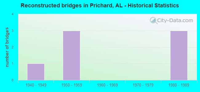
- Reconstructed bridges - Historical Statistics
- 11940-1949
- 31950-1959
- 01960-1969
- 01970-1979
- 31980-1989
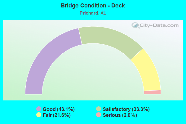
- Bridge Condition - Deck
- 43.1%Good
- 33.3%Satisfactory
- 21.6%Fair
- 2.0%Serious
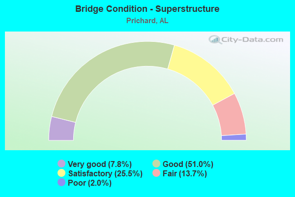
- Bridge Condition - Superstructure
- 7.8%Very good
- 51.0%Good
- 25.5%Satisfactory
- 13.7%Fair
- 2.0%Poor
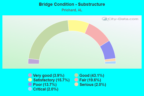
- Bridge Condition - Substructure
- 3.9%Very good
- 43.1%Good
- 15.7%Satisfactory
- 19.6%Fair
- 13.7%Poor
- 2.0%Serious
- 2.0%Critical
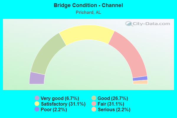
- Bridge Condition - Channel
- 6.7%Very good
- 26.7%Good
- 31.1%Satisfactory
- 31.1%Fair
- 2.2%Poor
- 2.2%Serious
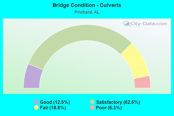
- Bridge Condition - Culverts
- 12.5%Good
- 62.5%Satisfactory
- 18.8%Fair
- 6.3%Poor
Find on map >> Show street view
Structure Number: 867, Location: 0.5 MI NW COUNTY RT296 (Lat: 34.403025, Lng: -86.624069), Route carried "on" structure: County highway 407, Year Built: 1930, Status: Posted for load, Structure Length: 1.86m (6.10ft), Average Daily Traffic: 10 (year 1985), Average Future Daily Traffic: 25 (year 2041), Design Load: H 10, Features Intersected: COTACO CREEK, Facility Carried by Structure: FORMAN BOTTOM ROAD
Minimum Vertical Clearance: 30+ m (98+ ft), Kilometerpoint: 0.010, Lanes on structure: 1, Owner: County Highway Agency, Approaching Roadway Width: 5.5m (18.0ft), Material/Design: Steel, Design/Construction: Stringer/Multi-beam, Number Of Spans In Main Unit: 1, Number Of Approach Spans: 1, Length of Maximum Span: 12.5m (41.0ft), Curb-To-Curb Width: 3.7m (12.1ft), Out-to-Out Width: 3.7m (12.1ft)
Condition: Deck: Serious, Superstructure: Fair, Substructure: Fair, Channel: Fair, Operating Rating: 2.7 metric tons, Method Used To Determine Operating Rating: Load Factor (LF), Inventory Rating: 1.8 metric tons, Method Used To Determine Inventory Rating: Load Factor (LF), Structural Evaluation: High priority of replacement, Deck Geometry: Meets minimum limits, Waterway Adequacy: Meets minimum limits, Approach Roadway Alignment: Meets minimum limits, Bridge Posting: Required (Relationship of Operating Rating to Maximum Legal Load: > 39.9% below), Length Of Structure Improvement: 2.58m (8.46ft), Designated Inspection Frequency: Every 24 months, Other Special Inspection Frequency: Every 3 months, Inspection Date: December 2021, Other Special Inspection Date: December 2021, Bridge Improvement Cost: $212,000, Roadway Improvement Cost: $21,000, Total Project Cost: $233,000 ( Estimate for 2022), Deck Structure Type: Wood or Timber, Wearing Surface/Protective System: Wearing Surface: Wood or Timber
Find on map >> Show street view
Structure Number: 1124, Location: 0.9 MI N JCT SR 35 (Lat: 34.636942, Lng: -86.271083), Route carried "on" structure: County highway 63, Year Built: 1934, Status: Open, Structure Length: 0.79m (2.59ft), Average Daily Traffic: 182 (year 1989), Truck Traffic: 7%, Average Future Daily Traffic: 235 (year 2039), Design Load: H 10, Features Intersected: COTTON COVE CREEK, Facility Carried by Structure: CO RT 8
Minimum Vertical Clearance: 30+ m (98+ ft), Kilometerpoint: 0.010, Lanes on structure: 2, Owner: County Highway Agency, Approaching Roadway Width: 7.3m (24.0ft), Material/Design: Concrete, Design/Construction: Slab, Number Of Spans In Main Unit: 2, Length of Maximum Span: 4.0m (13.1ft), Curb-To-Curb Width: 7.9m (25.9ft), Out-to-Out Width: 8.5m (27.9ft)
Condition: Deck: Good, Superstructure: Good, Substructure: Satisfactory, Channel: Satisfactory, Operating Rating: 32.7 metric tons, Method Used To Determine Operating Rating: Field evaluation and documented engineering judgment, Inventory Rating: 23.6 metric tons, Method Used To Determine Inventory Rating: Field evaluation and documented engineering judgment, Structural Evaluation: Equal to present minimum criteria, Deck Geometry: Somewhat better than minimum adequacy, Waterway Adequacy: Equal to present minimum criteria, Approach Roadway Alignment: Better than present minimum criteria, Length Of Structure Improvement: 1.44m (4.72ft), Designated Inspection Frequency: Every 24 months, Inspection Date: December 2021, Bridge Improvement Cost: $277,000, Roadway Improvement Cost: $28,000, Total Project Cost: $305,000 ( Estimate for 2022)
Find on map >> Show street view
Structure Number: 1143, Location: 2.3 MI NW HAZEL GREEN (Lat: 34.947144, Lng: -86.608114), Route carried "on" structure: County highway 262, Year Built: 1934, Status: Posted for load, Structure Length: 2.50m (8.20ft), Average Daily Traffic: 1,250 (year 1992), Truck Traffic: 1%, Average Future Daily Traffic: 1,855 (year 2040), Design Load: H 15, Features Intersected: COPELAND CREEK, Facility Carried by Structure: CHARITY LA
Minimum Vertical Clearance: 30+ m (98+ ft), Kilometerpoint: 0.010, Lanes on structure: 2, Owner: County Highway Agency, Approaching Roadway Width: 7.9m (25.9ft), Material/Design: Steel, Design/Construction: Stringer/Multi-beam, Number Of Spans In Main Unit: 2, Length of Maximum Span: 6.7m (22.0ft), Curb-To-Curb Width: 7.3m (24.0ft), Out-to-Out Width: 7.8m (25.6ft)
Condition: Deck: Fair, Superstructure: Satisfactory, Substructure: Satisfactory, Channel: Satisfactory, Operating Rating: 20.8 metric tons, Method Used To Determine Operating Rating: Allowable Stress (AS), Inventory Rating: 11.6 metric tons, Method Used To Determine Inventory Rating: Allowable Stress (AS), Structural Evaluation: High priority of replacement, Deck Geometry: Meets minimum limits, Waterway Adequacy: Somewhat better than minimum adequacy, Approach Roadway Alignment: Equal to present minimum criteria, Bridge Posting: Required (Relationship of Operating Rating to Maximum Legal Load: > 39.9% below), Length Of Structure Improvement: 3.38m (11.09ft), Designated Inspection Frequency: Every 24 months, Other Special Inspection Frequency: Every 12 months, Inspection Date: October 2020, Other Special Inspection Date: October 2021, Bridge Improvement Cost: $580,000, Roadway Improvement Cost: $58,000, Total Project Cost: $638,000 ( Estimate for 2022), Deck Structure Type: Concrete Cast-file-Place
Find on map >> Show street view
Structure Number: 1558, Location: 5.5 MI. W. JCT. CO.RD. 10 (Lat: 34.904619, Lng: -87.985922), Route carried "on" structure: County highway 14, Year Built: 1937, Status: Posted for load, Structure Length: 3.47m (11.38ft), Average Daily Traffic: 505 (year 1989), Truck Traffic: 10%, Average Future Daily Traffic: 1,010 (year 2030), Features Intersected: BRUSH CREEK
Minimum Vertical Clearance: 30+ m (98+ ft), Kilometerpoint: 0.010, Lanes on structure: 2, Owner: County Highway Agency, Approaching Roadway Width: 7.3m (24.0ft), Material/Design: Steel continuous, Design/Construction: Stringer/Multi-beam, Number Of Spans In Main Unit: 3, Length of Maximum Span: 12.8m (42.0ft), Curb-To-Curb Width: 5.9m (19.4ft), Out-to-Out Width: 5.9m (19.4ft)
Condition: Deck: Fair, Superstructure: Satisfactory, Substructure: Satisfactory, Channel: Fair, Operating Rating: 25.7 metric tons, Method Used To Determine Operating Rating: Allowable Stress (AS), Inventory Rating: 14.9 metric tons, Method Used To Determine Inventory Rating: Allowable Stress (AS), Structural Evaluation: Meets minimum limits, Waterway Adequacy: Superior to present desirable criteria, Approach Roadway Alignment: Equal to present minimum criteria, Bridge Posting: Required (Relationship of Operating Rating to Maximum Legal Load: 30.0 - 39.9% below), Length Of Structure Improvement: 4.37m (14.34ft), Designated Inspection Frequency: Every 24 months, Other Special Inspection Frequency: Every 12 months, Inspection Date: May 2020, Other Special Inspection Date: June 2021, Bridge Improvement Cost: $569,000, Roadway Improvement Cost: $57,000, Total Project Cost: $626,000 ( Estimate for 2022), Deck Structure Type: Concrete Cast-file-Place, Wearing Surface/Protective System: Wearing Surface: Bituminous
Find on map >> Show street view
Structure Number: 1572, Location: 1.3 MI E JCT CO RT 57 (Lat: 34.513333, Lng: -87.136667), Route carried "on" structure: County highway 28, Year Built: 1963, Status: Open, Structure Length: 0.79m (2.59ft), Average Daily Traffic: 90 (year 1989), Average Future Daily Traffic: 150 (year 2034), Features Intersected: FLAT CREEK
Minimum Vertical Clearance: 7.56m (24.80ft), Kilometerpoint: 0.010, Lanes on structure: 1, Owner: County Highway Agency, Approaching Roadway Width: 7.9m (25.9ft), Material/Design: Concrete, Design/Construction: Culvert, Number Of Spans In Main Unit: 2, Length of Maximum Span: 3.7m (12.1ft)
Condition: Channel: Fair, Culverts: Satisfactory, Operating Rating: 88.9 metric tons, Method Used To Determine Operating Rating: Load Factor (LF), Inventory Rating: 88.9 metric tons, Method Used To Determine Inventory Rating: Load Factor (LF), Structural Evaluation: Equal to present minimum criteria, Waterway Adequacy: Equal to present minimum criteria, Approach Roadway Alignment: Better than present minimum criteria, Length Of Structure Improvement: 1.44m (4.72ft), Designated Inspection Frequency: Every 24 months, Inspection Date: Febuary 2021, Bridge Improvement Cost: $408,000, Roadway Improvement Cost: $41,000, Total Project Cost: $449,000 ( Estimate for 2022)
Find on map >> Show street view
Structure Number: 1856, Location: 0.1 MI JCT CO RD 324 (Lat: 34.919275, Lng: -86.503414), Route carried "on" structure: County highway 261, Year Built: 1938, Status: Posted for load, Structure Length: 0.73m (2.40ft), Average Daily Traffic: 500 (year 1992), Truck Traffic: 1%, Average Future Daily Traffic: 595 (year 2034), Design Load: H 15, Features Intersected: UPPER CREEK, Facility Carried by Structure: UPCREEK RD
Minimum Vertical Clearance: 30+ m (98+ ft), Kilometerpoint: 0.010, Lanes on structure: 2, Owner: County Highway Agency, Approaching Roadway Width: 7.3m (24.0ft), Skew: 4 degrees, Material/Design: Concrete, Design/Construction: Tee Beam, Number Of Spans In Main Unit: 1, Length of Maximum Span: 7.3m (24.0ft), Curb-To-Curb Width: 7.3m (24.0ft), Out-to-Out Width: 7.9m (25.9ft)
Condition: Deck: Satisfactory, Superstructure: Good, Substructure: Satisfactory, Channel: Satisfactory, Operating Rating: 41.6 metric tons, Method Used To Determine Operating Rating: Load Factor (LF), Inventory Rating: 25.0 metric tons, Method Used To Determine Inventory Rating: Load Factor (LF), Structural Evaluation: Equal to present minimum criteria, Deck Geometry: Meets minimum limits, Waterway Adequacy: Equal to present minimum criteria, Approach Roadway Alignment: Equal to present minimum criteria, Bridge Posting: Required (Relationship of Operating Rating to Maximum Legal Load: 10.0 - 19.9% below), Length Of Structure Improvement: 1.38m (4.53ft), Designated Inspection Frequency: Every 24 months, Other Special Inspection Frequency: Every 12 months, Inspection Date: July 2020, Other Special Inspection Date: July 2021, Bridge Improvement Cost: $236,000, Roadway Improvement Cost: $24,000, Total Project Cost: $260,000 ( Estimate for 2022), Deck Structure Type: Concrete Cast-file-Place
Find on map >> Show street view
Structure Number: 2116, Location: 2 MI S CO RD 55 (Lat: 30.823097, Lng: -88.165658), Route carried "on" structure: US 45, Year Built: 1931, Year Reconstructed: 1940, Status: Open, Structure Length: 1.13m (3.71ft), Average Daily Traffic: 10,232 (year 2019), Truck Traffic: 15%, Average Future Daily Traffic: 15,348 (year 2039), Design Load: H 15, Features Intersected: MAGEE CREEK
Minimum Vertical Clearance: 30+ m (98+ ft), Kilometerpoint: 18.235, Lanes on structure: 2, Base Highway Network: Yes, Owner: State Highway Agency, Approaching Roadway Width: 8.5m (27.9ft), Material/Design: Concrete, Design/Construction: Culvert, Number Of Spans In Main Unit: 3, Length of Maximum Span: 3.7m (12.1ft)
Condition: Channel: Satisfactory, Culverts: Fair, Operating Rating: 69.2 metric tons, Method Used To Determine Operating Rating: Load Factor (LF), Inventory Rating: 41.5 metric tons, Method Used To Determine Inventory Rating: Load Factor (LF), Structural Evaluation: Somewhat better than minimum adequacy, Waterway Adequacy: Equal to present minimum criteria, Approach Roadway Alignment: Equal to present minimum criteria, Length Of Structure Improvement: 1.80m (5.91ft), Designated Inspection Frequency: Every 24 months, Inspection Date: August 2020, Bridge Improvement Cost: $405,000, Roadway Improvement Cost: $41,000, Total Project Cost: $446,000 ( Estimate for 2022)
Find on map >> Show street view
Structure Number: 2751, Location: 0.4 MI N US 45 (Lat: 30.721667, Lng: -88.080000), Route carried "on" structure: City street , Year Built: 1943, Status: Closed, Structure Length: 1.07m (3.51ft), Average Daily Traffic: 11,232 (year 2020), Truck Traffic: 1%, Average Future Daily Traffic: 16,736 (year 2040), Design Load: H 15, Features Intersected: TOULMIN SPRINGS, Facility Carried by Structure: CRAFT HWY
Minimum Vertical Clearance: 30+ m (98+ ft), Kilometerpoint: 0.100, Lanes on structure: 2, Owner: City or Municipal Highway Agency, Approaching Roadway Width: 9.8m (32.2ft), Material/Design: Concrete, Design/Construction: Tee Beam, Number Of Spans In Main Unit: 1, Length of Maximum Span: 10.7m (35.1ft), Curb-To-Curb Width: 7.3m (24.0ft), Out-to-Out Width: 8.0m (26.2ft)
Condition: Deck: Fair, Superstructure: Fair, Substructure: Poor, Channel: Satisfactory, Waterway Adequacy: Equal to present desirable criteria, Approach Roadway Alignment: Equal to present minimum criteria, Bridge Posting: Required (Relationship of Operating Rating to Maximum Legal Load: > 39.9% below), Length Of Structure Improvement: 1.74m (5.71ft), Designated Inspection Frequency: Every 24 months, Other Special Inspection Frequency: Every 6 months, Inspection Date: January 2022, Other Special Inspection Date: January 2022, Bridge Improvement Cost: $311,000, Roadway Improvement Cost: $31,000, Total Project Cost: $342,000 ( Estimate for 2022), Deck Structure Type: Concrete Cast-file-Place
Find on map >> Show street view
Structure Number: 2941, Location: 0.8 MI W WASSON AVE (Lat: 30.763333, Lng: -88.113333), Route carried "on" structure: City street , Year Built: 1946, Status: Posted for load, Structure Length: 6.28m (20.60ft), Average Daily Traffic: 11,607 (year 2021), Truck Traffic: 1%, Average Future Daily Traffic: 17,294 (year 2041), Design Load: H 15, Features Intersected: EIGHT MILE CREEK, Facility Carried by Structure: WHISTLER ST
Minimum Vertical Clearance: 30+ m (98+ ft), Kilometerpoint: 0.900, Lanes on structure: 2, Owner: City or Municipal Highway Agency, Approaching Roadway Width: 7.3m (24.0ft), Material/Design: Concrete, Design/Construction: Tee Beam, Number Of Spans In Main Unit: 1, Number Of Approach Spans: 6, Length of Maximum Span: 11.6m (38.1ft), Curb-To-Curb Width: 7.2m (23.6ft), Out-to-Out Width: 8.9m (29.2ft)
Condition: Deck: Satisfactory, Superstructure: Poor, Substructure: Satisfactory, Channel: Satisfactory, Operating Rating: 11.4 metric tons, Method Used To Determine Operating Rating: Load Factor (LF), Inventory Rating: 6.8 metric tons, Method Used To Determine Inventory Rating: Load Factor (LF), Structural Evaluation: High priority of replacement, Deck Geometry: High priority of replacement, Waterway Adequacy: Better than present minimum criteria, Approach Roadway Alignment: Equal to present minimum criteria, Bridge Posting: Required (Relationship of Operating Rating to Maximum Legal Load: > 39.9% below), Length Of Structure Improvement: 7.32m (24.02ft), Designated Inspection Frequency: Every 24 months, Other Special Inspection Frequency: Every 12 months, Inspection Date: December 2021, Other Special Inspection Date: December 2021, Bridge Improvement Cost: $1,455,000, Roadway Improvement Cost: $146,000, Total Project Cost: $1,601,000 ( Estimate for 2022), Deck Structure Type: Concrete Cast-file-Place
Find on map >> Show street view
Structure Number: 3206, Location: 0.3 MI W US 45 (Lat: 30.750000, Lng: -88.120000), Route carried "on" structure: City street , Year Built: 1948, Status: Posted for load, Structure Length: 0.85m (2.79ft), Average Daily Traffic: 6,340 (year 2021), Truck Traffic: 2%, Average Future Daily Traffic: 9,446 (year 2041), Design Load: H 15, Features Intersected: TOULMIN SPRINGS, Facility Carried by Structure: WOLF RIDGE RD
Minimum Vertical Clearance: 30+ m (98+ ft), Kilometerpoint: 0.399, Lanes on structure: 2, Owner: City or Municipal Highway Agency, Approaching Roadway Width: 9.8m (32.2ft), Material/Design: Concrete, Design/Construction: Tee Beam, Number Of Spans In Main Unit: 1, Length of Maximum Span: 8.5m (27.9ft), Curb-To-Curb Width: 7.3m (24.0ft), Out-to-Out Width: 8.7m (28.5ft)
Condition: Deck: Fair, Superstructure: Good, Substructure: Good, Channel: Satisfactory, Operating Rating: 21.5 metric tons, Method Used To Determine Operating Rating: Load Factor (LF), Inventory Rating: 12.9 metric tons, Method Used To Determine Inventory Rating: Load Factor (LF), Structural Evaluation: High priority of replacement, Deck Geometry: High priority of replacement, Waterway Adequacy: Equal to present minimum criteria, Approach Roadway Alignment: Better than present minimum criteria, Bridge Posting: Required (Relationship of Operating Rating to Maximum Legal Load: > 39.9% below), Length Of Structure Improvement: 1.52m (4.99ft), Designated Inspection Frequency: Every 24 months, Other Special Inspection Frequency: Every 12 months, Inspection Date: December 2021, Other Special Inspection Date: December 2021, Bridge Improvement Cost: $292,000, Roadway Improvement Cost: $29,000, Total Project Cost: $321,000 ( Estimate for 2022), Deck Structure Type: Concrete Cast-file-Place
Find on map >> Show street view
Structure Number: 3217, Location: 0.6 MI N TURNER RD (Lat: 30.761667, Lng: -88.100000), Route carried "on" structure: City street , Year Built: 1948, Status: Posted for load, Structure Length: 0.85m (2.79ft), Average Daily Traffic: 2,473 (year 2022), Truck Traffic: 1%, Average Future Daily Traffic: 3,462 (year 2042), Design Load: H 15, Features Intersected: GUM TREE BRANCH, Facility Carried by Structure: WASSON AVE
Minimum Vertical Clearance: 30+ m (98+ ft), Kilometerpoint: 0.599, Lanes on structure: 2, Owner: City or Municipal Highway Agency, Approaching Roadway Width: 9.8m (32.2ft), Material/Design: Concrete, Design/Construction: Tee Beam, Number Of Spans In Main Unit: 1, Length of Maximum Span: 8.5m (27.9ft), Curb-To-Curb Width: 7.2m (23.6ft), Out-to-Out Width: 8.9m (29.2ft)
Condition: Deck: Fair, Superstructure: Fair, Substructure: Poor, Channel: Fair, Operating Rating: 12.9 metric tons, Method Used To Determine Operating Rating: Load Factor (LF), Inventory Rating: 7.7 metric tons, Method Used To Determine Inventory Rating: Load Factor (LF), Structural Evaluation: High priority of replacement, Deck Geometry: High priority of replacement, Waterway Adequacy: Somewhat better than minimum adequacy, Approach Roadway Alignment: Meets minimum limits, Bridge Posting: Required (Relationship of Operating Rating to Maximum Legal Load: > 39.9% below), Length Of Structure Improvement: 1.51m (4.95ft), Designated Inspection Frequency: Every 24 months, Underwater Inspection Frequency: Every 48 months, Other Special Inspection Frequency: Every 6 months, Inspection Date: January 2022, Underwater Inspection Date: July 2018, Other Special Inspection Date: January 2022, Bridge Improvement Cost: $301,000, Roadway Improvement Cost: $30,000, Total Project Cost: $331,000 ( Estimate for 2022), Deck Structure Type: Concrete Cast-file-Place
Find on map >> Show street view
Structure Number: 7204, Location: 0.7 MI N I-65 (Lat: 30.749050, Lng: -88.113867), Route carried "on" structure: US 45, Year Built: 1931, Year Reconstructed: 1961, Status: Open, Structure Length: 0.79m (2.59ft), Average Daily Traffic: 25,569 (year 2019), Truck Traffic: 4%, Average Future Daily Traffic: 38,354 (year 2039), Design Load: H 15, Features Intersected: PETERSON BRANCH
Minimum Vertical Clearance: 30+ m (98+ ft), Kilometerpoint: 8.105, Lanes on structure: 4, Base Highway Network: Yes, Owner: State Highway Agency, Approaching Roadway Width: 13.2m (43.3ft), Skew: 3 degrees, Material/Design: Concrete, Design/Construction: Culvert, Number Of Spans In Main Unit: 2, Length of Maximum Span: 3.0m (9.8ft)
Condition: Channel: Satisfactory, Culverts: Fair, Operating Rating: 87.8 metric tons, Method Used To Determine Operating Rating: Load Factor (LF), Inventory Rating: 52.6 metric tons, Method Used To Determine Inventory Rating: Load Factor (LF), Structural Evaluation: Somewhat better than minimum adequacy, Waterway Adequacy: Equal to present minimum criteria, Approach Roadway Alignment: Better than present minimum criteria, Length Of Structure Improvement: 1.45m (4.76ft), Designated Inspection Frequency: Every 24 months, Inspection Date: July 2020, Bridge Improvement Cost: $3,916,000, Roadway Improvement Cost: $392,000, Total Project Cost: $4,308,000 ( Estimate for 2022)
Find on map >> Show street view
Structure Number: 7205, Location: 0.7 MI N SR 213 (Lat: 30.770339, Lng: -88.134561), Route carried "on" structure: US 45, Year Built: 1931, Year Reconstructed: 1961, Status: Open, Structure Length: 0.91m (2.99ft), Average Daily Traffic: 5,963 (year 2018), Truck Traffic: 12%, Average Future Daily Traffic: 8,945 (year 2038), Design Load: H 15, Features Intersected: MYERS STREAM
Minimum Vertical Clearance: 30+ m (98+ ft), Kilometerpoint: 11.179, Lanes on structure: 4, Base Highway Network: Yes, Owner: State Highway Agency, Approaching Roadway Width: 13.4m (44.0ft), Material/Design: Concrete, Design/Construction: Culvert, Number Of Spans In Main Unit: 5, Length of Maximum Span: 1.5m (4.9ft)
Condition: Channel: Satisfactory, Culverts: Satisfactory, Operating Rating: 43.5 metric tons, Method Used To Determine Operating Rating: Field evaluation and documented engineering judgment, Inventory Rating: 32.7 metric tons, Method Used To Determine Inventory Rating: Field evaluation and documented engineering judgment, Structural Evaluation: Equal to present minimum criteria, Waterway Adequacy: Equal to present minimum criteria, Approach Roadway Alignment: Equal to present desirable criteria, Length Of Structure Improvement: 1.59m (5.22ft), Designated Inspection Frequency: Every 24 months, Inspection Date: July 2020, Bridge Improvement Cost: $513,000, Roadway Improvement Cost: $51,000, Total Project Cost: $564,000 ( Estimate for 2022)
Find on map >> Show street view
Structure Number: 7206, Location: 1 MI N SR 213 (Lat: 30.773528, Lng: -88.138058), Route carried "on" structure: US 45, Year Built: 1931, Year Reconstructed: 1961, Status: Open, Structure Length: 0.64m (2.10ft), Average Daily Traffic: 4,086 (year 2018), Truck Traffic: 5%, Average Future Daily Traffic: 6,129 (year 2038), Design Load: H 15, Features Intersected: CRYSTAL SPRINGS BRANCH
Minimum Vertical Clearance: 30+ m (98+ ft), Kilometerpoint: 11.666, Lanes on structure: 2, Base Highway Network: Yes, Owner: State Highway Agency, Approaching Roadway Width: 9.1m (29.9ft), Material/Design: Concrete, Design/Construction: Culvert, Number Of Spans In Main Unit: 2, Length of Maximum Span: 3.0m (9.8ft)
Condition: Channel: Satisfactory, Culverts: Satisfactory, Operating Rating: 45.2 metric tons, Method Used To Determine Operating Rating: Load Factor (LF), Inventory Rating: 27.1 metric tons, Method Used To Determine Inventory Rating: Load Factor (LF), Structural Evaluation: Equal to present minimum criteria, Waterway Adequacy: Equal to present minimum criteria, Approach Roadway Alignment: Equal to present desirable criteria, Length Of Structure Improvement: 1.26m (4.13ft), Designated Inspection Frequency: Every 24 months, Inspection Date: July 2020, Bridge Improvement Cost: $277,000, Roadway Improvement Cost: $28,000, Total Project Cost: $305,000 ( Estimate for 2022)
Find on map >> Show street view
Structure Number: 7674, Location: JCT I-65 * US 45 (Lat: 30.740261, Lng: -88.107394), Route carried "on" structure: US 45, Year Built: 1962, Status: Open, Structure Length: 9.11m (29.89ft), Average Daily Traffic: 9,242 (year 2018), Truck Traffic: 7%, Average Future Daily Traffic: 13,863 (year 2038), Design Load: HS 20, Features Intersected: I-65
Minimum Vertical Clearance: 30+ m (98+ ft), Kilometerpoint: 6.935, Lanes on structure: 3, Lanes under structure: 8, Base Highway Network: Yes, Owner: State Highway Agency, Approaching Roadway Width: 9.4m (30.8ft), Skew: 10 degrees, Material/Design: Concrete continuous, Design/Construction: Tee Beam, Number Of Spans In Main Unit: 4, Length of Maximum Span: 25.0m (82.0ft), Curb-To-Curb Width: 12.2m (40.0ft), Out-to-Out Width: 13.8m (45.3ft)
Condition: Deck: Fair, Superstructure: Fair, Substructure: Fair, Operating Rating: 43.1 metric tons, Method Used To Determine Operating Rating: Load Factor (LF), Inventory Rating: 25.8 metric tons, Method Used To Determine Inventory Rating: Load Factor (LF), Structural Evaluation: Somewhat better than minimum adequacy, Deck Geometry: Meets minimum limits, Underclear: High priority of corrective action, Approach Roadway Alignment: Equal to present minimum criteria, Length Of Structure Improvement: 10.08m (33.07ft), Designated Inspection Frequency: Every 24 months, Inspection Date: July 2020, Bridge Improvement Cost: $3,110,000, Roadway Improvement Cost: $311,000, Total Project Cost: $3,421,000 ( Estimate for 2022), Deck Structure Type: Concrete Cast-file-Place
Find on map >> Show street view
Structure Number: 7675, Location: JCT I-65 * US 45 (Lat: 30.740344, Lng: -88.107297), Route carried "on" structure: US 45, Year Built: 1962, Status: Open, Structure Length: 9.11m (29.89ft), Average Daily Traffic: 9,242 (year 2018), Truck Traffic: 7%, Average Future Daily Traffic: 13,863 (year 2038), Design Load: HS 20, Features Intersected: I-65
Minimum Vertical Clearance: 30+ m (98+ ft), Kilometerpoint: 6.935, Lanes on structure: 3, Lanes under structure: 8, Base Highway Network: Yes, Owner: State Highway Agency, Approaching Roadway Width: 10.1m (33.1ft), Skew: 10 degrees, Material/Design: Concrete continuous, Design/Construction: Tee Beam, Number Of Spans In Main Unit: 4, Length of Maximum Span: 25.0m (82.0ft), Curb-To-Curb Width: 12.2m (40.0ft), Out-to-Out Width: 13.8m (45.3ft)
Condition: Deck: Fair, Superstructure: Fair, Substructure: Satisfactory, Operating Rating: 43.1 metric tons, Method Used To Determine Operating Rating: Load Factor (LF), Inventory Rating: 25.8 metric tons, Method Used To Determine Inventory Rating: Load Factor (LF), Structural Evaluation: Somewhat better than minimum adequacy, Deck Geometry: Meets minimum limits, Underclear: Meets minimum limits, Approach Roadway Alignment: Equal to present minimum criteria, Length Of Structure Improvement: 10.08m (33.07ft), Designated Inspection Frequency: Every 24 months, Inspection Date: July 2020, Bridge Improvement Cost: $3,110,000, Roadway Improvement Cost: $311,000, Total Project Cost: $3,421,000 ( Estimate for 2022), Deck Structure Type: Concrete Cast-file-Place
Find on map >> Show street view
Structure Number: 7711, Location: 0.3 MI W TELEGRAPH RD (Lat: 30.750000, Lng: -88.081667), Route carried "on" structure: City street , Year Built: 1962, Status: Open, Structure Length: 0.86m (2.82ft), Average Daily Traffic: 250 (year 2022), Truck Traffic: 1%, Average Future Daily Traffic: 375 (year 2042), Design Load: HS 20, Features Intersected: DRAINAGE DITCH, Facility Carried by Structure: E PETAIN ST
Minimum Vertical Clearance: 30+ m (98+ ft), Kilometerpoint: 0.200, Lanes on structure: 2, Owner: City or Municipal Highway Agency, Approaching Roadway Width: 6.1m (20.0ft), Material/Design: Concrete, Design/Construction: Culvert, Number Of Spans In Main Unit: 2, Length of Maximum Span: 3.0m (9.8ft), Curb or Sidewalk Widths: Left: 0.9m (3.0ft), Right: 0.9m (3.0ft), Curb-To-Curb Width: 6.0m (19.7ft), Out-to-Out Width: 7.8m (25.6ft)
Condition: Channel: Fair, Culverts: Satisfactory, Operating Rating: 41.7 metric tons, Method Used To Determine Operating Rating: Load Factor (LF), Inventory Rating: 25.0 metric tons, Method Used To Determine Inventory Rating: Load Factor (LF), Structural Evaluation: Equal to present minimum criteria, Deck Geometry: High priority of corrective action, Waterway Adequacy: Meets minimum limits, Approach Roadway Alignment: Equal to present minimum criteria, Length Of Structure Improvement: 1.53m (5.02ft), Designated Inspection Frequency: Every 24 months, Inspection Date: January 2022, Bridge Improvement Cost: $247,000, Roadway Improvement Cost: $25,000, Total Project Cost: $272,000 ( Estimate for 2022)
Find on map >> Show street view
Structure Number: 8579, Location: 1.3 MI N SR 17 (Lat: 30.755364, Lng: -88.093489), Route carried "on" structure: Interstate 65, Year Built: 1965, Status: Open, Structure Length: 1.52m (4.99ft), Average Daily Traffic: 70,680 (year 2018), Truck Traffic: 11%, Average Future Daily Traffic: 106,020 (year 2038), Design Load: HS 20, Features Intersected: GUM TREE BRANCH
Minimum Vertical Clearance: 30+ m (98+ ft), Kilometerpoint: 15.632, Lanes on structure: 6, Base Highway Network: Yes, Owner: State Highway Agency, Approaching Roadway Width: 36.0m (118.1ft), Skew: 14 degrees, Material/Design: Concrete, Design/Construction: Culvert, Number Of Spans In Main Unit: 3, Length of Maximum Span: 3.7m (12.1ft)
Condition: Channel: Fair, Culverts: Fair, Operating Rating: 61.3 metric tons, Method Used To Determine Operating Rating: Load Factor (LF), Inventory Rating: 36.7 metric tons, Method Used To Determine Inventory Rating: Load Factor (LF), Structural Evaluation: Somewhat better than minimum adequacy, Waterway Adequacy: Somewhat better than minimum adequacy, Approach Roadway Alignment: Equal to present desirable criteria, Length Of Structure Improvement: 2.20m (7.22ft), Designated Inspection Frequency: Every 24 months, Inspection Date: March 2020, Bridge Improvement Cost: $2,674,000, Roadway Improvement Cost: $267,000, Total Project Cost: $2,941,000 ( Estimate for 2022)
Find on map >> Show street view
Structure Number: 867, Location: 0.8 MI E US45 (Lat: 30.735000, Lng: -88.088333), Route carried "on" structure: City street , Year Built: 1965, Status: Posted for load, Structure Length: 0.58m (1.90ft), Average Daily Traffic: 4,138 (year 2022), Truck Traffic: 1%, Average Future Daily Traffic: 5,793 (year 2042), Design Load: H 15, Features Intersected: DRAINAGE DITCH, Facility Carried by Structure: PRICHARD AVE
Minimum Vertical Clearance: 30+ m (98+ ft), Kilometerpoint: 0.800, Lanes on structure: 2, Owner: City or Municipal Highway Agency, Approaching Roadway Width: 8.2m (26.9ft), Material/Design: Concrete, Design/Construction: Channel Beam, Number Of Spans In Main Unit: 1, Length of Maximum Span: 5.8m (19.0ft), Curb or Sidewalk Widths: Left: 1.4m (4.6ft), Right: 1.4m (4.6ft), Curb-To-Curb Width: 9.3m (30.5ft), Out-to-Out Width: 12.0m (39.4ft)
Condition: Deck: Satisfactory, Superstructure: Good, Substructure: Poor, Channel: Fair, Operating Rating: 21.8 metric tons, Method Used To Determine Operating Rating: Field evaluation and documented engineering judgment, Inventory Rating: 16.3 metric tons, Method Used To Determine Inventory Rating: Field evaluation and documented engineering judgment, Structural Evaluation: Meets minimum limits, Deck Geometry: Meets minimum limits, Waterway Adequacy: Equal to present desirable criteria, Approach Roadway Alignment: Better than present minimum criteria, Bridge Posting: Required (Relationship of Operating Rating to Maximum Legal Load: > 39.9% below), Length Of Structure Improvement: 1.18m (3.87ft), Designated Inspection Frequency: Every 24 months, Other Special Inspection Frequency: Every 12 months, Inspection Date: January 2022, Other Special Inspection Date: January 2022, Bridge Improvement Cost: $315,000, Roadway Improvement Cost: $32,000, Total Project Cost: $347,000 ( Estimate for 2022), Deck Structure Type: Concrete Precast Panels, Wearing Surface/Protective System: Wearing Surface: Bituminous
Find on map >> Show street view
Structure Number: 8781, Location: 0.3 MI W WASSON AVE (Lat: 30.761667, Lng: -88.105000), Route carried "on" structure: City street , Year Built: 1965, Status: Posted for load, Structure Length: 0.88m (2.89ft), Average Daily Traffic: 493 (year 2021), Truck Traffic: 1%, Average Future Daily Traffic: 750 (year 2041), Design Load: H 15, Features Intersected: PETERSON BRANCH, Facility Carried by Structure: WARREN STREET
Minimum Vertical Clearance: 30+ m (98+ ft), Kilometerpoint: 0.499, Lanes on structure: 2, Owner: City or Municipal Highway Agency, Approaching Roadway Width: 7.3m (24.0ft), Material/Design: Steel, Design/Construction: Culvert, Number Of Spans In Main Unit: 4, Length of Maximum Span: 1.8m (5.9ft)
Condition: Channel: Serious, Culverts: Poor, Operating Rating: 2.7 metric tons, Method Used To Determine Operating Rating: Load Factor (LF), Inventory Rating: 1.8 metric tons, Method Used To Determine Inventory Rating: Load Factor (LF), Structural Evaluation: High priority of replacement, Waterway Adequacy: Better than present minimum criteria, Approach Roadway Alignment: Better than present minimum criteria, Bridge Posting: Required (Relationship of Operating Rating to Maximum Legal Load: > 39.9% below), Length Of Structure Improvement: 1.55m (5.09ft), Designated Inspection Frequency: Every 24 months, Other Special Inspection Frequency: Every 3 months, Inspection Date: December 2021, Other Special Inspection Date: December 2021, Bridge Improvement Cost: $393,000, Roadway Improvement Cost: $39,000, Total Project Cost: $432,000 ( Estimate for 2022)
Find on map >> Show street view
Structure Number: 9445, Location: 1.7 MI E US 45 (Lat: 30.802983, Lng: -88.125222), Route carried "on" structure: State highway 158, Year Built: 1967, Status: Open, Structure Length: 5.00m (16.40ft), Average Daily Traffic: 13,992 (year 2019), Truck Traffic: 12%, Average Future Daily Traffic: 20,988 (year 2039), Design Load: HS 20, Features Intersected: COLLEGE PARKWAY
Minimum Vertical Clearance: 30+ m (98+ ft), Kilometerpoint: 9.511, Lanes on structure: 2, Lanes under structure: 2, Owner: State Highway Agency, Approaching Roadway Width: 8.7m (28.5ft), Material/Design: Concrete continuous, Design/Construction: Tee Beam, Number Of Spans In Main Unit: 4, Length of Maximum Span: 14.0m (45.9ft), Curb-To-Curb Width: 8.6m (28.2ft), Out-to-Out Width: 10.2m (33.5ft)
Condition: Deck: Fair, Superstructure: Fair, Substructure: Fair, Operating Rating: 65.3 metric tons, Method Used To Determine Operating Rating: Load Factor (LF), Inventory Rating: 39.0 metric tons, Method Used To Determine Inventory Rating: Load Factor (LF), Structural Evaluation: Somewhat better than minimum adequacy, Deck Geometry: High priority of replacement, Underclear: High priority of corrective action, Approach Roadway Alignment: Equal to present desirable criteria, Length Of Structure Improvement: 6.02m (19.75ft), Designated Inspection Frequency: Every 24 months, Inspection Date: April 2021, Bridge Improvement Cost: $1,361,000, Roadway Improvement Cost: $136,000, Total Project Cost: $1,497,000 ( Estimate for 2022), Deck Structure Type: Concrete Cast-file-Place
Find on map >> Show street view
Structure Number: 9707, Location: 400' E CRAFT HWY (Lat: 30.750000, Lng: -88.081667), Route carried "on" structure: City street , Year Built: 1968, Status: Open, Structure Length: 0.64m (2.10ft), Average Daily Traffic: 350 (year 2022), Truck Traffic: 2%, Average Future Daily Traffic: 500 (year 2042), Design Load: H 15, Features Intersected: DRAINAGE DITCH, Facility Carried by Structure: HAIG ST
Minimum Vertical Clearance: 30+ m (98+ ft), Kilometerpoint: 0.200, Lanes on structure: 2, Owner: City or Municipal Highway Agency, Approaching Roadway Width: 6.7m (22.0ft), Material/Design: Concrete, Design/Construction: Culvert, Number Of Spans In Main Unit: 2, Length of Maximum Span: 3.0m (9.8ft)
Condition: Channel: Fair, Culverts: Satisfactory, Operating Rating: 51.8 metric tons, Method Used To Determine Operating Rating: Load Factor (LF), Inventory Rating: 31.0 metric tons, Method Used To Determine Inventory Rating: Load Factor (LF), Structural Evaluation: Equal to present minimum criteria, Waterway Adequacy: Equal to present desirable criteria, Approach Roadway Alignment: Equal to present minimum criteria, Length Of Structure Improvement: 1.26m (4.13ft), Designated Inspection Frequency: Every 24 months, Inspection Date: January 2022, Bridge Improvement Cost: $2,475,000, Roadway Improvement Cost: $248,000, Total Project Cost: $2,723,000 ( Estimate for 2022)
Find on map >> Show street view
Structure Number: 10963, Location: 0.17 MI N E WHISTLER ST (Lat: 30.749700, Lng: -88.093200), Route carried "on" structure: City street , Year Built: 1973, Status: Posted for load, Structure Length: 0.73m (2.40ft), Average Daily Traffic: 2,404 (year 2021), Truck Traffic: 4%, Average Future Daily Traffic: 3,582 (year 2041), Design Load: H 15, Features Intersected: GUM TREE BRANCH, Facility Carried by Structure: TURNER ROAD
Minimum Vertical Clearance: 30+ m (98+ ft), Kilometerpoint: 1.199, Lanes on structure: 4, Owner: City or Municipal Highway Agency, Approaching Roadway Width: 12.8m (42.0ft), Material/Design: Concrete, Design/Construction: Channel Beam, Number Of Spans In Main Unit: 1, Length of Maximum Span: 7.3m (24.0ft), Curb or Sidewalk Widths: Left: 1.2m (3.9ft), Right: 1.2m (3.9ft), Curb-To-Curb Width: 13.3m (43.6ft), Out-to-Out Width: 16.9m (55.4ft)
Condition: Deck: Satisfactory, Superstructure: Satisfactory, Substructure: Serious, Channel: Fair, Operating Rating: 2.7 metric tons, Method Used To Determine Operating Rating: Load Factor (LF), Inventory Rating: 1.8 metric tons, Method Used To Determine Inventory Rating: Load Factor (LF), Structural Evaluation: High priority of corrective action, Deck Geometry: High priority of replacement, Waterway Adequacy: Equal to present desirable criteria, Approach Roadway Alignment: Equal to present desirable criteria, Bridge Posting: Required (Relationship of Operating Rating to Maximum Legal Load: > 39.9% below), Length Of Structure Improvement: 1.38m (4.53ft), Designated Inspection Frequency: Every 24 months, Other Special Inspection Frequency: Every 3 months, Inspection Date: December 2021, Other Special Inspection Date: December 2021, Bridge Improvement Cost: $519,000, Roadway Improvement Cost: $52,000, Total Project Cost: $571,000 ( Estimate for 2022), Deck Structure Type: Concrete Precast Panels, Wearing Surface/Protective System: Wearing Surface: Bituminous
Find on map >> Show street view
Structure Number: 11196, Location: 0.1 MI E GARRISON AVE (Lat: 30.729700, Lng: -88.094453), Route carried "on" structure: City street , Year Built: 1974, Status: Open, Structure Length: 0.93m (3.05ft), Average Daily Traffic: 838 (year 2022), Truck Traffic: 1%, Average Future Daily Traffic: 1,249 (year 2042), Design Load: H 15, Features Intersected: TOULMIN SPRINGS, Facility Carried by Structure: COLLEGE STREET
Minimum Vertical Clearance: 30+ m (98+ ft), Kilometerpoint: 0.100, Lanes on structure: 2, Owner: City or Municipal Highway Agency, Approaching Roadway Width: 7.9m (25.9ft), Material/Design: Concrete, Design/Construction: Channel Beam, Number Of Spans In Main Unit: 1, Length of Maximum Span: 9.3m (30.5ft), Curb-To-Curb Width: 6.9m (22.6ft), Out-to-Out Width: 7.5m (24.6ft)
Condition: Deck: Satisfactory, Superstructure: Good, Substructure: Fair, Channel: Good, Operating Rating: 46.8 metric tons, Method Used To Determine Operating Rating: Load Factor (LF), Inventory Rating: 27.4 metric tons, Method Used To Determine Inventory Rating: Load Factor (LF), Structural Evaluation: Somewhat better than minimum adequacy, Deck Geometry: Meets minimum limits, Waterway Adequacy: Equal to present desirable criteria, Approach Roadway Alignment: Better than present minimum criteria, Length Of Structure Improvement: 1.60m (5.25ft), Designated Inspection Frequency: Every 24 months, Inspection Date: January 2022, Bridge Improvement Cost: $263,000, Roadway Improvement Cost: $26,000, Total Project Cost: $289,000 ( Estimate for 2022), Deck Structure Type: Concrete Cast-file-Place, Wearing Surface/Protective System: Wearing Surface: Bituminous
Find on map >> Show street view
Structure Number: 11204, Location: 0.2 MI E US 45 (Lat: 30.731039, Lng: -88.094150), Route carried "on" structure: City street , Year Built: 1974, Status: Posted for load, Structure Length: 0.94m (3.08ft), Average Daily Traffic: 2,071 (year 2022), Truck Traffic: 1%, Average Future Daily Traffic: 2,900 (year 2042), Design Load: H 15, Features Intersected: TOULMIN SPRINGS, Facility Carried by Structure: W CLARK AVE
Minimum Vertical Clearance: 30+ m (98+ ft), Kilometerpoint: 0.200, Lanes on structure: 2, Owner: City or Municipal Highway Agency, Approaching Roadway Width: 7.9m (25.9ft), Material/Design: Concrete, Design/Construction: Channel Beam, Number Of Spans In Main Unit: 1, Length of Maximum Span: 9.4m (30.8ft), Curb-To-Curb Width: 6.8m (22.3ft), Out-to-Out Width: 7.4m (24.3ft)
Condition: Deck: Satisfactory, Superstructure: Good, Substructure: Poor, Channel: Good, Operating Rating: 23.4 metric tons, Method Used To Determine Operating Rating: Load Factor (LF), Inventory Rating: 13.7 metric tons, Method Used To Determine Inventory Rating: Load Factor (LF), Structural Evaluation: Meets minimum limits, Deck Geometry: High priority of replacement, Waterway Adequacy: Equal to present desirable criteria, Approach Roadway Alignment: Equal to present minimum criteria, Bridge Posting: Required (Relationship of Operating Rating to Maximum Legal Load: > 39.9% below), Length Of Structure Improvement: 1.62m (5.31ft), Designated Inspection Frequency: Every 24 months, Other Special Inspection Frequency: Every 12 months, Inspection Date: January 2022, Other Special Inspection Date: January 2022, Bridge Improvement Cost: $266,000, Roadway Improvement Cost: $27,000, Total Project Cost: $293,000 ( Estimate for 2022), Deck Structure Type: Concrete Precast Panels, Wearing Surface/Protective System: Wearing Surface: Bituminous
Find on map >> Show street view
Structure Number: 11207, Location: 0.3 MI E US 45 (Lat: 30.734017, Lng: -88.096250), Route carried "on" structure: City street , Year Built: 1974, Status: Open, Structure Length: 0.94m (3.08ft), Average Daily Traffic: 904 (year 2022), Average Future Daily Traffic: 1,347 (year 2042), Design Load: H 15, Features Intersected: TOULMIN SPRINGS, Facility Carried by Structure: GARRISON AVE
Minimum Vertical Clearance: 30+ m (98+ ft), Kilometerpoint: 0.299, Lanes on structure: 2, Owner: City or Municipal Highway Agency, Approaching Roadway Width: 6.1m (20.0ft), Material/Design: Concrete, Design/Construction: Channel Beam, Number Of Spans In Main Unit: 1, Length of Maximum Span: 9.4m (30.8ft), Curb-To-Curb Width: 6.8m (22.3ft), Out-to-Out Width: 7.5m (24.6ft)
Condition: Deck: Good, Superstructure: Good, Substructure: Fair, Channel: Satisfactory, Operating Rating: 46.8 metric tons, Method Used To Determine Operating Rating: Load Factor (LF), Inventory Rating: 27.4 metric tons, Method Used To Determine Inventory Rating: Load Factor (LF), Structural Evaluation: Somewhat better than minimum adequacy, Deck Geometry: Meets minimum limits, Waterway Adequacy: Equal to present desirable criteria, Approach Roadway Alignment: Equal to present desirable criteria, Length Of Structure Improvement: 1.62m (5.31ft), Designated Inspection Frequency: Every 24 months, Inspection Date: January 2022, Bridge Improvement Cost: $266,000, Roadway Improvement Cost: $27,000, Total Project Cost: $293,000 ( Estimate for 2022), Deck Structure Type: Concrete Precast Panels, Wearing Surface/Protective System: Wearing Surface: Bituminous
Find on map >> Show street view
Structure Number: 11214, Location: 0.2 MI E US 45 (Lat: 30.743333, Lng: -88.101667), Route carried "on" structure: City street , Year Built: 1974, Status: Posted for load, Structure Length: 0.73m (2.40ft), Average Daily Traffic: 446 (year 2022), Truck Traffic: 2%, Average Future Daily Traffic: 664 (year 2042), Design Load: H 15, Features Intersected: TOULMIN SPRINGS, Facility Carried by Structure: THOMAS AVE
Minimum Vertical Clearance: 30+ m (98+ ft), Kilometerpoint: 0.200, Lanes on structure: 2, Owner: City or Municipal Highway Agency, Approaching Roadway Width: 7.3m (24.0ft), Material/Design: Concrete, Design/Construction: Channel Beam, Number Of Spans In Main Unit: 1, Length of Maximum Span: 7.3m (24.0ft), Curb-To-Curb Width: 6.7m (22.0ft), Out-to-Out Width: 7.1m (23.3ft)
Condition: Deck: Good, Superstructure: Good, Substructure: Poor, Channel: Good, Operating Rating: 25.6 metric tons, Method Used To Determine Operating Rating: Load Factor (LF), Inventory Rating: 15.3 metric tons, Method Used To Determine Inventory Rating: Load Factor (LF), Structural Evaluation: Meets minimum limits, Deck Geometry: Meets minimum limits, Waterway Adequacy: Equal to present desirable criteria, Approach Roadway Alignment: Somewhat better than minimum adequacy, Bridge Posting: Required (Relationship of Operating Rating to Maximum Legal Load: > 39.9% below), Length Of Structure Improvement: 1.38m (4.53ft), Designated Inspection Frequency: Every 24 months, Other Special Inspection Frequency: Every 12 months, Inspection Date: January 2022, Other Special Inspection Date: January 2022, Bridge Improvement Cost: $217,000, Roadway Improvement Cost: $22,000, Total Project Cost: $239,000 ( Estimate for 2022), Deck Structure Type: Concrete Precast Panels, Wearing Surface/Protective System: Wearing Surface: Bituminous
Find on map >> Show street view
Structure Number: 11227, Location: 0.2 MI S MAGEE ST (Lat: 30.743333, Lng: -88.101667), Route carried "on" structure: City street , Year Built: 1974, Status: Open, Structure Length: 0.76m (2.49ft), Average Daily Traffic: 861 (year 2022), Truck Traffic: 2%, Average Future Daily Traffic: 1,258 (year 2042), Design Load: H 15, Features Intersected: TOULMIN SPRINGS, Facility Carried by Structure: ROSEDALE AVE
Minimum Vertical Clearance: 30+ m (98+ ft), Kilometerpoint: 0.100, Lanes on structure: 2, Owner: City or Municipal Highway Agency, Approaching Roadway Width: 5.5m (18.0ft), Skew: 3 degrees, Material/Design: Concrete, Design/Construction: Channel Beam, Number Of Spans In Main Unit: 1, Length of Maximum Span: 7.6m (24.9ft), Curb-To-Curb Width: 7.1m (23.3ft), Out-to-Out Width: 7.1m (23.3ft)
Condition: Deck: Good, Superstructure: Satisfactory, Substructure: Poor, Channel: Very good, Operating Rating: 43.5 metric tons, Method Used To Determine Operating Rating: Field evaluation and documented engineering judgment, Inventory Rating: 32.7 metric tons, Method Used To Determine Inventory Rating: Field evaluation and documented engineering judgment, Structural Evaluation: Meets minimum limits, Deck Geometry: Meets minimum limits, Waterway Adequacy: Equal to present desirable criteria, Approach Roadway Alignment: Somewhat better than minimum adequacy, Length Of Structure Improvement: 1.41m (4.63ft), Designated Inspection Frequency: Every 24 months, Other Special Inspection Frequency: Every 12 months, Inspection Date: January 2022, Other Special Inspection Date: January 2022, Bridge Improvement Cost: $223,000, Roadway Improvement Cost: $22,000, Total Project Cost: $245,000 ( Estimate for 2022), Deck Structure Type: Concrete Precast Panels, Wearing Surface/Protective System: Wearing Surface: Bituminous
Find on map >> Show street view
Structure Number: 11229, Location: 0.3 MI E US 45 (Lat: 30.741667, Lng: -88.100000), Route carried "on" structure: City street , Year Built: 1974, Status: Open, Structure Length: 0.73m (2.40ft), Average Daily Traffic: 400 (year 2022), Truck Traffic: 1%, Average Future Daily Traffic: 600 (year 2042), Design Load: H 15, Features Intersected: TOULMIN SPRINGS, Facility Carried by Structure: FIRST AVE
Minimum Vertical Clearance: 30+ m (98+ ft), Kilometerpoint: 0.299, Lanes on structure: 2, Owner: City or Municipal Highway Agency, Approaching Roadway Width: 5.5m (18.0ft), Material/Design: Concrete, Design/Construction: Channel Beam, Number Of Spans In Main Unit: 1, Length of Maximum Span: 7.3m (24.0ft), Curb-To-Curb Width: 6.7m (22.0ft), Out-to-Out Width: 7.1m (23.3ft)
Condition: Deck: Satisfactory, Superstructure: Satisfactory, Substructure: Fair, Channel: Very good, Operating Rating: 51.8 metric tons, Method Used To Determine Operating Rating: Load Factor (LF), Inventory Rating: 31.0 metric tons, Method Used To Determine Inventory Rating: Load Factor (LF), Structural Evaluation: Somewhat better than minimum adequacy, Deck Geometry: Meets minimum limits, Waterway Adequacy: Equal to present desirable criteria, Approach Roadway Alignment: Equal to present desirable criteria, Length Of Structure Improvement: 1.38m (4.53ft), Designated Inspection Frequency: Every 24 months, Other Special Inspection Frequency: Every 12 months, Inspection Date: January 2022, Other Special Inspection Date: January 2022, Bridge Improvement Cost: $217,000, Roadway Improvement Cost: $22,000, Total Project Cost: $239,000 ( Estimate for 2022), Deck Structure Type: Concrete Precast Panels, Wearing Surface/Protective System: Wearing Surface: Bituminous
Find on map >> Show street view
Structure Number: 11231, Location: 0.3 MI E US 45 (Lat: 30.741667, Lng: -88.098333), Route carried "on" structure: City street , Year Built: 1974, Status: Open, Structure Length: 0.73m (2.40ft), Average Daily Traffic: 400 (year 2022), Truck Traffic: 1%, Average Future Daily Traffic: 575 (year 2042), Design Load: H 15, Features Intersected: TOULMIN SPRINGS, Facility Carried by Structure: GRANT AVE
Minimum Vertical Clearance: 30+ m (98+ ft), Kilometerpoint: 0.299, Lanes on structure: 2, Owner: City or Municipal Highway Agency, Approaching Roadway Width: 8.1m (26.6ft), Material/Design: Concrete, Design/Construction: Channel Beam, Number Of Spans In Main Unit: 1, Length of Maximum Span: 7.3m (24.0ft), Curb-To-Curb Width: 6.7m (22.0ft), Out-to-Out Width: 7.0m (23.0ft)
Condition: Deck: Good, Superstructure: Satisfactory, Substructure: Fair, Channel: Good, Operating Rating: 49.7 metric tons, Method Used To Determine Operating Rating: Load Factor (LF), Inventory Rating: 29.8 metric tons, Method Used To Determine Inventory Rating: Load Factor (LF), Structural Evaluation: Somewhat better than minimum adequacy, Deck Geometry: Meets minimum limits, Waterway Adequacy: Equal to present desirable criteria, Approach Roadway Alignment: Equal to present desirable criteria, Length Of Structure Improvement: 1.38m (4.53ft), Designated Inspection Frequency: Every 24 months, Other Special Inspection Frequency: Every 12 months, Inspection Date: January 2022, Other Special Inspection Date: January 2022, Bridge Improvement Cost: $217,000, Roadway Improvement Cost: $22,000, Total Project Cost: $239,000 ( Estimate for 2022), Deck Structure Type: Concrete Precast Panels, Wearing Surface/Protective System: Wearing Surface: Bituminous
Find on map >> Show street view
Structure Number: 11234, Location: 0.1 MI S MAGEE ST (Lat: 30.740000, Lng: -88.098333), Route carried "on" structure: City street , Year Built: 1974, Status: Open, Structure Length: 0.73m (2.40ft), Average Daily Traffic: 188 (year 2022), Truck Traffic: 1%, Average Future Daily Traffic: 275 (year 2042), Design Load: H 15, Features Intersected: TOULMIN SPRINGS, Facility Carried by Structure: NEELEY AVE
Minimum Vertical Clearance: 30+ m (98+ ft), Kilometerpoint: 0.200, Lanes on structure: 2, Owner: City or Municipal Highway Agency, Approaching Roadway Width: 6.6m (21.7ft), Material/Design: Concrete, Design/Construction: Channel Beam, Number Of Spans In Main Unit: 1, Length of Maximum Span: 7.3m (24.0ft), Curb-To-Curb Width: 6.6m (21.7ft), Out-to-Out Width: 7.0m (23.0ft)
Condition: Deck: Good, Superstructure: Good, Substructure: Fair, Channel: Fair, Operating Rating: 49.7 metric tons, Method Used To Determine Operating Rating: Load Factor (LF), Inventory Rating: 29.8 metric tons, Method Used To Determine Inventory Rating: Load Factor (LF), Structural Evaluation: Somewhat better than minimum adequacy, Deck Geometry: Meets minimum limits, Waterway Adequacy: Equal to present desirable criteria, Approach Roadway Alignment: Better than present minimum criteria, Length Of Structure Improvement: 1.37m (4.49ft), Designated Inspection Frequency: Every 24 months, Other Special Inspection Frequency: Every 12 months, Inspection Date: January 2022, Other Special Inspection Date: January 2022, Bridge Improvement Cost: $216,000, Roadway Improvement Cost: $22,000, Total Project Cost: $238,000 ( Estimate for 2022), Deck Structure Type: Concrete Precast Panels, Wearing Surface/Protective System: Wearing Surface: Bituminous
Find on map >> Show street view
Structure Number: 1124, Location: 0.1 MI S MAGEE ST (Lat: 30.740000, Lng: -88.098333), Route carried "on" structure: City street , Year Built: 1974, Status: Open, Structure Length: 0.64m (2.10ft), Average Daily Traffic: 271 (year 2022), Average Future Daily Traffic: 404 (year 2042), Design Load: H 15, Features Intersected: TOULMIN SPRINGS, Facility Carried by Structure: STRAUSS AVE
Minimum Vertical Clearance: 30+ m (98+ ft), Kilometerpoint: 0.100, Lanes on structure: 2, Owner: City or Municipal Highway Agency, Approaching Roadway Width: 5.6m (18.4ft), Material/Design: Concrete, Design/Construction: Culvert, Number Of Spans In Main Unit: 2, Length of Maximum Span: 3.0m (9.8ft)
Condition: Channel: Good, Culverts: Good, Operating Rating: 69.5 metric tons, Method Used To Determine Operating Rating: Load Factor (LF), Inventory Rating: 41.6 metric tons, Method Used To Determine Inventory Rating: Load Factor (LF), Structural Evaluation: Better than present minimum criteria, Waterway Adequacy: Equal to present desirable criteria, Approach Roadway Alignment: Equal to present desirable criteria, Length Of Structure Improvement: 1.26m (4.13ft), Designated Inspection Frequency: Every 24 months, Inspection Date: January 2022, Bridge Improvement Cost: $291,000, Roadway Improvement Cost: $29,000, Total Project Cost: $320,000 ( Estimate for 2022)
Find on map >> Show street view
Structure Number: 11245, Location: 0.2 MI E US 45 (Lat: 30.728819, Lng: -88.094403), Route carried "on" structure: City street , Year Built: 1974, Status: Open, Structure Length: 0.94m (3.08ft), Average Daily Traffic: 617 (year 2022), Truck Traffic: 1%, Average Future Daily Traffic: 919 (year 2042), Design Load: H 15, Features Intersected: TOULMIN SPRINGS, Facility Carried by Structure: CHASTANG AVE
Minimum Vertical Clearance: 30+ m (98+ ft), Kilometerpoint: 0.200, Lanes on structure: 2, Owner: City or Municipal Highway Agency, Approaching Roadway Width: 7.9m (25.9ft), Skew: 1 degrees, Material/Design: Concrete, Design/Construction: Channel Beam, Number Of Spans In Main Unit: 1, Length of Maximum Span: 9.4m (30.8ft), Curb-To-Curb Width: 6.9m (22.6ft), Out-to-Out Width: 7.5m (24.6ft)
Condition: Deck: Satisfactory, Superstructure: Satisfactory, Substructure: Fair, Channel: Good, Operating Rating: 46.8 metric tons, Method Used To Determine Operating Rating: Load Factor (LF), Inventory Rating: 27.4 metric tons, Method Used To Determine Inventory Rating: Load Factor (LF), Structural Evaluation: Somewhat better than minimum adequacy, Deck Geometry: Meets minimum limits, Waterway Adequacy: Equal to present desirable criteria, Approach Roadway Alignment: Equal to present desirable criteria, Length Of Structure Improvement: 1.62m (5.31ft), Designated Inspection Frequency: Every 24 months, Inspection Date: January 2022, Bridge Improvement Cost: $266,000, Roadway Improvement Cost: $27,000, Total Project Cost: $293,000 ( Estimate for 2022), Deck Structure Type: Concrete Cast-file-Place, Wearing Surface/Protective System: Wearing Surface: Bituminous
Find on map >> Show street view
Structure Number: 1143, Location: 0.3 MI N US 45 (Lat: 30.741667, Lng: -88.098333), Route carried "on" structure: City street , Year Built: 1975, Status: Posted for load, Structure Length: 0.56m (1.84ft), Average Daily Traffic: 1,454 (year 2022), Truck Traffic: 1%, Average Future Daily Traffic: 2,036 (year 2042), Design Load: H 15, Features Intersected: TOULMIN SPRINGS, Facility Carried by Structure: RICH AVE
Minimum Vertical Clearance: 30+ m (98+ ft), Kilometerpoint: 0.299, Lanes on structure: 2, Owner: City or Municipal Highway Agency, Approaching Roadway Width: 5.6m (18.4ft), Skew: 2 degrees, Material/Design: Concrete, Design/Construction: Channel Beam, Number Of Spans In Main Unit: 1, Length of Maximum Span: 5.6m (18.4ft), Curb-To-Curb Width: 6.6m (21.7ft), Out-to-Out Width: 7.1m (23.3ft)
Condition: Deck: Satisfactory, Superstructure: Good, Substructure: Poor, Channel: Good, Operating Rating: 2.7 metric tons, Method Used To Determine Operating Rating: Load Factor (LF), Inventory Rating: 1.8 metric tons, Method Used To Determine Inventory Rating: Load Factor (LF), Structural Evaluation: High priority of corrective action, Deck Geometry: High priority of replacement, Waterway Adequacy: Equal to present desirable criteria, Approach Roadway Alignment: Equal to present desirable criteria, Bridge Posting: Required (Relationship of Operating Rating to Maximum Legal Load: > 39.9% below), Length Of Structure Improvement: 1.15m (3.77ft), Designated Inspection Frequency: Every 24 months, Other Special Inspection Frequency: Every 12 months, Inspection Date: January 2022, Other Special Inspection Date: January 2022, Bridge Improvement Cost: $182,000, Roadway Improvement Cost: $18,000, Total Project Cost: $200,000 ( Estimate for 2022), Deck Structure Type: Concrete Precast Panels, Wearing Surface/Protective System: Wearing Surface: Bituminous
Find on map >> Show street view
Structure Number: 11445, Location: 0.17 MI N US 45 (Lat: 30.731667, Lng: -88.090000), Route carried "on" structure: City street , Year Built: 1975, Status: Closed, Structure Length: 1.46m (4.79ft), Average Daily Traffic: 3,072 (year 2022), Truck Traffic: 1%, Average Future Daily Traffic: 4,577 (year 2042), Design Load: HS 20, Features Intersected: TOULMIN SPRINGS, Facility Carried by Structure: W SWEENEY'S LN
Minimum Vertical Clearance: 30+ m (98+ ft), Kilometerpoint: 0.200, Lanes on structure: 2, Owner: City or Municipal Highway Agency, Approaching Roadway Width: 5.8m (19.0ft), Material/Design: Concrete, Design/Construction: Channel Beam, Number Of Spans In Main Unit: 2, Length of Maximum Span: 7.3m (24.0ft), Curb or Sidewalk Widths: Left: 0.9m (3.0ft), Right: 0.9m (3.0ft), Curb-To-Curb Width: 6.6m (21.7ft), Out-to-Out Width: 9.4m (30.8ft)
Condition: Deck: Good, Superstructure: Good, Substructure: Critical, Channel: Very good, Operating Rating: 26.4 metric tons, Method Used To Determine Operating Rating: Load Factor (LF), Inventory Rating: 15.9 metric tons, Method Used To Determine Inventory Rating: Load Factor (LF), Structural Evaluation: High priority of replacement, Waterway Adequacy: Equal to present desirable criteria, Approach Roadway Alignment: Equal to present desirable criteria, Bridge Posting: Required (Relationship of Operating Rating to Maximum Legal Load: 30.0 - 39.9% below), Length Of Structure Improvement: 2.14m (7.02ft), Designated Inspection Frequency: Every 24 months, Other Special Inspection Frequency: Every 12 months, Inspection Date: January 2022, Other Special Inspection Date: January 2022, Bridge Improvement Cost: $441,000, Roadway Improvement Cost: $44,000, Total Project Cost: $485,000 ( Estimate for 2022), Deck Structure Type: Concrete Precast Panels
Find on map >> Show street view
Structure Number: 12142, Location: 0.1 MI E US 45 (Lat: 30.735000, Lng: -88.095000), Route carried "on" structure: City street , Year Built: 1979, Status: Open, Structure Length: 1.22m (4.00ft), Average Daily Traffic: 4,951 (year 2022), Truck Traffic: 1%, Average Future Daily Traffic: 6,932 (year 2042), Design Load: HS 20, Features Intersected: TOULMIN SPRINGS, Facility Carried by Structure: PRICHARD AVE.
Minimum Vertical Clearance: 30+ m (98+ ft), Kilometerpoint: 0.100, Lanes on structure: 2, Owner: City or Municipal Highway Agency, Approaching Roadway Width: 11.6m (38.1ft), Material/Design: Concrete, Design/Construction: Culvert, Number Of Spans In Main Unit: 2, Length of Maximum Span: 3.7m (12.1ft), Curb-To-Curb Width: 11.6m (38.1ft), Out-to-Out Width: 12.1m (39.7ft)
Condition: Channel: Poor, Culverts: Satisfactory, Operating Rating: 69.9 metric tons, Method Used To Determine Operating Rating: Load Factor (LF), Inventory Rating: 41.8 metric tons, Method Used To Determine Inventory Rating: Load Factor (LF), Structural Evaluation: Equal to present minimum criteria, Deck Geometry: Somewhat better than minimum adequacy, Waterway Adequacy: Equal to present minimum criteria, Approach Roadway Alignment: Equal to present minimum criteria, Length Of Structure Improvement: 1.89m (6.20ft), Designated Inspection Frequency: Every 24 months, Inspection Date: January 2022, Bridge Improvement Cost: $437,000, Roadway Improvement Cost: $44,000, Total Project Cost: $481,000 ( Estimate for 2022)
Find on map >> Show street view
Structure Number: 12194, Location: 3000' S PRICHARD AVE (Lat: 30.723333, Lng: -88.085000), Route carried "on" structure: City street , Year Built: 1979, Status: Open, Structure Length: 1.16m (3.81ft), Average Daily Traffic: 7,556 (year 2022), Truck Traffic: 1%, Average Future Daily Traffic: 10,579 (year 2042), Design Load: HS 20, Features Intersected: TOULMIN SPRINGS, Facility Carried by Structure: WILSON AVE
Minimum Vertical Clearance: 30+ m (98+ ft), Kilometerpoint: 0.079, Lanes on structure: 4, Owner: City or Municipal Highway Agency, Approaching Roadway Width: 13.4m (44.0ft), Material/Design: Concrete, Design/Construction: Culvert, Number Of Spans In Main Unit: 3, Length of Maximum Span: 3.7m (12.1ft), Curb or Sidewalk Widths: Left: 1.5m (4.9ft), Right: 1.5m (4.9ft)
Condition: Channel: Fair, Culverts: Satisfactory, Operating Rating: 88.9 metric tons, Method Used To Determine Operating Rating: Load Factor (LF), Inventory Rating: 88.9 metric tons, Method Used To Determine Inventory Rating: Load Factor (LF), Structural Evaluation: Equal to present minimum criteria, Waterway Adequacy: Equal to present desirable criteria, Approach Roadway Alignment: Equal to present desirable criteria, Length Of Structure Improvement: 1.84m (6.04ft), Designated Inspection Frequency: Every 24 months, Inspection Date: January 2022, Bridge Improvement Cost: $1,060,000, Roadway Improvement Cost: $106,000, Total Project Cost: $1,166,000 ( Estimate for 2022)
Find on map >> Show street view
Structure Number: 15502, Location: 0.6 MI N US 45 (Lat: 30.746447, Lng: -88.101061), Route carried "on" structure: Interstate 65, Year Built: 1965, Year Reconstructed: 1992, Status: Open, Structure Length: 5.15m (16.90ft), Average Daily Traffic: 80,762 (year 2018), Truck Traffic: 11%, Average Future Daily Traffic: 121,143 (year 2038), Design Load: HS 20, Features Intersected: MAIN STREET
Minimum Vertical Clearance: 30+ m (98+ ft), Kilometerpoint: 14.445, Lanes on structure: 8, Lanes under structure: 4, Base Highway Network: Yes, Owner: State Highway Agency, Approaching Roadway Width: 43.6m (143.0ft), Skew: 30 degrees, Material/Design: Concrete continuous, Design/Construction: Tee Beam, Number Of Spans In Main Unit: 3, Length of Maximum Span: 19.5m (64.0ft), Curb-To-Curb Width: 43.6m (143.0ft), Out-to-Out Width: 45.3m (148.6ft)
Condition: Deck: Fair, Superstructure: Fair, Substructure: Fair, Operating Rating: 39.7 metric tons, Method Used To Determine Operating Rating: Load Factor (LF), Inventory Rating: 24.6 metric tons, Method Used To Determine Inventory Rating: Load Factor (LF), Structural Evaluation: Somewhat better than minimum adequacy, Deck Geometry: Superior to present desirable criteria, Underclear: Meets minimum limits, Approach Roadway Alignment: Better than present minimum criteria, Length Of Structure Improvement: 6.17m (20.24ft), Designated Inspection Frequency: Every 24 months, Inspection Date: May 2020, Bridge Improvement Cost: $6,265,000, Roadway Improvement Cost: $627,000, Total Project Cost: $6,892,000 ( Estimate for 2022), Deck Structure Type: Concrete Cast-file-Place
Find on map >> Show street view
Structure Number: 15504, Location: 0.9 MI N US 45 (Lat: 30.750433, Lng: -88.097094), Route carried "on" structure: Interstate 65, Year Built: 1965, Year Reconstructed: 1992, Status: Open, Structure Length: 10.94m (35.89ft), Average Daily Traffic: 40,381 (year 2018), Truck Traffic: 11%, Average Future Daily Traffic: 60,572 (year 2038), Design Load: HS 20, Features Intersected: TURNER RD * WHISTLER AVE
Minimum Vertical Clearance: 30+ m (98+ ft), Kilometerpoint: 15.041, Lanes on structure: 3, Lanes under structure: 4, Base Highway Network: Yes, Owner: State Highway Agency, Approaching Roadway Width: 18.0m (59.1ft), Skew: 39 degrees, Material/Design: Steel, Design/Construction: Stringer/Multi-beam, Number Of Spans In Main Unit: 6, Length of Maximum Span: 21.6m (70.9ft), Curb-To-Curb Width: 18.2m (59.7ft), Out-to-Out Width: 19.0m (62.3ft)
Condition: Deck: Fair, Superstructure: Satisfactory, Substructure: Satisfactory, Operating Rating: 64.1 metric tons, Method Used To Determine Operating Rating: Load Factor (LF), Inventory Rating: 38.4 metric tons, Method Used To Determine Inventory Rating: Load Factor (LF), Structural Evaluation: Equal to present minimum criteria, Deck Geometry: Better than present minimum criteria, Underclear: Meets minimum limits, Approach Roadway Alignment: Equal to present desirable criteria, Length Of Structure Improvement: 11.83m (38.81ft), Designated Inspection Frequency: Every 24 months, Inspection Date: May 2020, Bridge Improvement Cost: $5,031,000, Roadway Improvement Cost: $503,000, Total Project Cost: $5,534,000 ( Estimate for 2022), Deck Structure Type: Concrete Cast-file-Place