Bridge Statistics for Poteau, Oklahoma (OK)
Condition, Traffic, Stress, Structural Evaluation, Project Costs
- New bridges - historical statistics
- 11920-1929
- 81930-1939
- 71940-1949
- 31950-1959
- 51960-1969
- 91970-1979
- 21980-1989
- 51990-1999
- 222000-2009
- 12020-2022
- Reconstructed bridges - Historical Statistics
- 31960-1969
- 01970-1979
- 11980-1989
- Bridge Condition - Deck
- 20.0%Very good
- 30.0%Good
- 33.3%Satisfactory
- 13.3%Fair
- 3.3%Poor
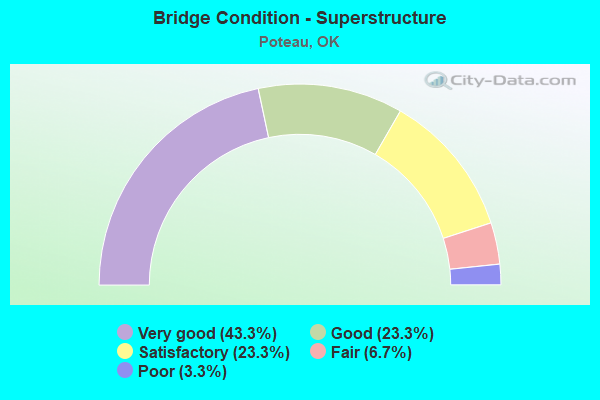
- Bridge Condition - Superstructure
- 43.3%Very good
- 23.3%Good
- 23.3%Satisfactory
- 6.7%Fair
- 3.3%Poor
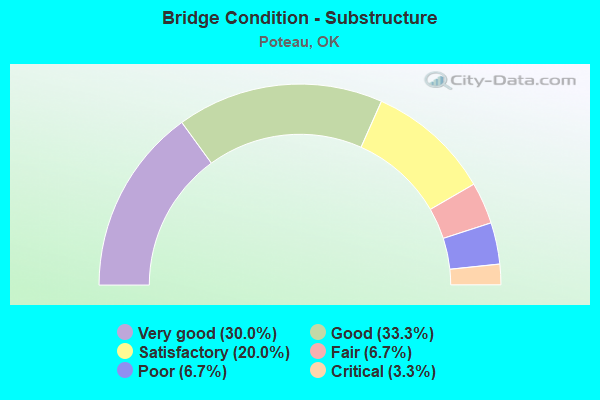
- Bridge Condition - Substructure
- 30.0%Very good
- 33.3%Good
- 20.0%Satisfactory
- 6.7%Fair
- 6.7%Poor
- 3.3%Critical
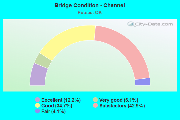
- Bridge Condition - Channel
- 12.2%Excellent
- 6.1%Very good
- 34.7%Good
- 42.9%Satisfactory
- 4.1%Fair
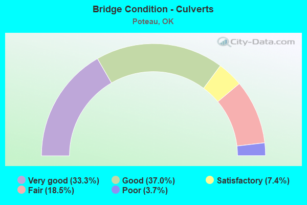
- Bridge Condition - Culverts
- 33.3%Very good
- 37.0%Good
- 7.4%Satisfactory
- 18.5%Fair
- 3.7%Poor
Find on map >> Show street view
Structure Number: 25658, Location: 0.20 E JCT US-271 (Lat: 35.096667, Lng: -94.628889), Route carried "on" structure: State highway 112, Year Built: 2000, Status: Open, Structure Length: 6.19m (20.31ft), Average Daily Traffic: 4,650 (year 2020), Truck Traffic: 16%, Average Future Daily Traffic: 7,440 (year 2040), Design Load: HS 20, Features Intersected: KANSAS CITY SOUTHERN R.R
Minimum Vertical Clearance: 30+ m (98+ ft), Kilometerpoint: 0.322, Lanes on structure: 2, Base Highway Network: Yes, Owner: State Highway Agency, Approaching Roadway Width: 11.4m (37.4ft), Material/Design: Prestressed concrete, Design/Construction: Stringer/Multi-beam, Number Of Spans In Main Unit: 3, Length of Maximum Span: 24.1m (79.1ft), Curb or Sidewalk Widths: Left: 0.5m (1.6ft), Right: 0.5m (1.6ft), Curb-To-Curb Width: 11.4m (37.4ft), Out-to-Out Width: 12.3m (40.4ft)
Condition: Deck: Good, Superstructure: Very good, Substructure: Good, Operating Rating: 79.8 metric tons, Method Used To Determine Operating Rating: Load Factor (LF), Inventory Rating: 46.3 metric tons, Method Used To Determine Inventory Rating: Load Factor (LF), Structural Evaluation: Better than present minimum criteria, Deck Geometry: Equal to present minimum criteria, Underclear: Better than present minimum criteria, Approach Roadway Alignment: Equal to present desirable criteria, Length Of Structure Improvement: 6.91m (22.67ft), Designated Inspection Frequency: Every 24 months, Inspection Date: June 2020, Bridge Improvement Cost: $582,000, Roadway Improvement Cost: $961,000, Total Project Cost: $1,631,000 ( Estimate for 2015), Deck Structure Type: Concrete Cast-file-Place, Wearing Surface/Protective System: Wearing Surface: Monolithic Concrete, Membrane: Preformed Fabric, Deck Protection: Epoxy Coated Reinforcing
Find on map >> Show street view
Structure Number: 25659, Location: JCT US-59/SH-112 (Lat: 35.094744, Lng: -94.632236), Route carried "on" structure: State highway 112, Year Built: 2000, Status: Open, Structure Length: 6.90m (22.64ft), Average Daily Traffic: 4,650 (year 2020), Truck Traffic: 16%, Average Future Daily Traffic: 7,440 (year 2040), Design Load: HS 20, Features Intersected: U.S. 59 UNDER
Minimum Vertical Clearance: 30+ m (98+ ft), Kilometerpoint: 0.000, Lanes on structure: 3, Lanes under structure: 4, Base Highway Network: Yes, Owner: State Highway Agency, Approaching Roadway Width: 8.5m (27.9ft), Skew: 2 degrees, Material/Design: Prestressed concrete, Design/Construction: Stringer/Multi-beam, Number Of Spans In Main Unit: 4, Length of Maximum Span: 18.0m (59.1ft), Curb or Sidewalk Widths: Left: 0.5m (1.6ft), Right: 0.5m (1.6ft), Curb-To-Curb Width: 16.3m (53.5ft), Out-to-Out Width: 17.2m (56.4ft)
Condition: Deck: Good, Superstructure: Very good, Substructure: Good, Operating Rating: 66.2 metric tons, Method Used To Determine Operating Rating: Load Factor (LF), Inventory Rating: 39.0 metric tons, Method Used To Determine Inventory Rating: Load Factor (LF), Structural Evaluation: Better than present minimum criteria, Deck Geometry: Better than present minimum criteria, Underclear: Equal to present minimum criteria, Approach Roadway Alignment: Equal to present desirable criteria, Length Of Structure Improvement: 9.51m (31.20ft), Designated Inspection Frequency: Every 24 months, Inspection Date: June 2020, Bridge Improvement Cost: $767,000, Roadway Improvement Cost: $1,265,000, Total Project Cost: $2,147,000 ( Estimate for 2015), Deck Structure Type: Concrete Cast-file-Place, Wearing Surface/Protective System: Wearing Surface: Monolithic Concrete, Membrane: Preformed Fabric, Deck Protection: Epoxy Coated Reinforcing
Find on map >> Show street view
Structure Number: 2568, Location: 3.50 N JCT US-271 (Lat: 35.080106, Lng: -94.640767), Route carried "on" structure: US 59, Year Built: 2000, Status: Open, Structure Length: 0.81m (2.66ft), Average Daily Traffic: 11,300 (year 2020), Truck Traffic: 16%, Average Future Daily Traffic: 18,080 (year 2040), Design Load: HL 93, Features Intersected: CREEK
Minimum Vertical Clearance: 30+ m (98+ ft), Kilometerpoint: 9.064, Lanes on structure: 4, Base Highway Network: Yes, Owner: State Highway Agency, Approaching Roadway Width: 34.4m (112.9ft), Skew: 13 degrees, Material/Design: Concrete, Design/Construction: Culvert, Number Of Spans In Main Unit: 2, Length of Maximum Span: 3.0m (9.8ft), Curb or Sidewalk Widths: Left: 0.3m (1.0ft), Right: 0.3m (1.0ft), Curb-To-Curb Width: 75.0m (246.1ft), Out-to-Out Width: 75.6m (248.0ft)
Condition: Channel: Very good, Culverts: Very good, Structural Evaluation: Equal to present desirable criteria, Deck Geometry: Superior to present desirable criteria, Waterway Adequacy: Equal to present desirable criteria, Approach Roadway Alignment: Equal to present desirable criteria, Length Of Structure Improvement: 0.63m (2.07ft), Designated Inspection Frequency: Every 24 months, Inspection Date: June 2020, Bridge Improvement Cost: $230,000, Roadway Improvement Cost: $380,000, Total Project Cost: $644,000 ( Estimate for 2015)
Find on map >> Show street view
Structure Number: 25681, Location: 3.30 N JCT US-271 (Lat: 35.079231, Lng: -94.641142), Route carried "on" structure: US 59, Year Built: 2000, Status: Open, Structure Length: 1.14m (3.74ft), Average Daily Traffic: 11,300 (year 2020), Truck Traffic: 16%, Average Future Daily Traffic: 18,080 (year 2040), Design Load: HL 93, Features Intersected: POLK CREEK
Minimum Vertical Clearance: 30+ m (98+ ft), Kilometerpoint: 8.546, Lanes on structure: 4, Base Highway Network: Yes, Owner: State Highway Agency, Approaching Roadway Width: 34.4m (112.9ft), Skew: 13 degrees, Material/Design: Concrete, Design/Construction: Culvert, Number Of Spans In Main Unit: 2, Length of Maximum Span: 4.0m (13.1ft), Curb or Sidewalk Widths: Left: 0.3m (1.0ft), Right: 0.3m (1.0ft), Curb-To-Curb Width: 130.8m (429.1ft), Out-to-Out Width: 131.4m (431.1ft)
Condition: Channel: Excellent, Culverts: Very good, Structural Evaluation: Equal to present desirable criteria, Deck Geometry: Superior to present desirable criteria, Waterway Adequacy: Superior to present desirable criteria, Approach Roadway Alignment: Equal to present desirable criteria, Length Of Structure Improvement: 0.84m (2.76ft), Designated Inspection Frequency: Every 24 months, Inspection Date: June 2020, Bridge Improvement Cost: $243,000, Roadway Improvement Cost: $401,000, Total Project Cost: $680,000 ( Estimate for 2015)
Find on map >> Show street view
Structure Number: 26391, Location: 0.80 N JCT US-271 (Lat: 35.041403, Lng: -94.645358), Route carried "on" structure: US 59, Year Built: 2000, Status: Open, Structure Length: 6.19m (20.31ft), Average Daily Traffic: 5,750 (year 2020), Truck Traffic: 16%, Average Future Daily Traffic: 9,200 (year 2040), Design Load: HS 20, Features Intersected: MCMURTREY CREEK
Minimum Vertical Clearance: 30+ m (98+ ft), Kilometerpoint: 1.287, Lanes on structure: 2, Base Highway Network: Yes, Owner: State Highway Agency, Approaching Roadway Width: 11.4m (37.4ft), Skew: 2 degrees, Material/Design: Prestressed concrete, Design/Construction: Girder and Floorbeam System, Number Of Spans In Main Unit: 3, Length of Maximum Span: 20.4m (66.9ft), Curb or Sidewalk Widths: Left: 0.5m (1.6ft), Right: 0.5m (1.6ft), Curb-To-Curb Width: 12.0m (39.4ft), Out-to-Out Width: 12.9m (42.3ft)
Condition: Deck: Very good, Superstructure: Very good, Substructure: Very good, Channel: Excellent, Operating Rating: 84.4 metric tons, Method Used To Determine Operating Rating: Load Factor (LF), Inventory Rating: 48.1 metric tons, Method Used To Determine Inventory Rating: Load Factor (LF), Structural Evaluation: Equal to present desirable criteria, Deck Geometry: Better than present minimum criteria, Waterway Adequacy: Superior to present desirable criteria, Approach Roadway Alignment: Equal to present desirable criteria, Length Of Structure Improvement: 8.98m (29.46ft), Designated Inspection Frequency: Every 24 months, Inspection Date: June 2020, Bridge Improvement Cost: $730,000, Roadway Improvement Cost: $1,204,000, Total Project Cost: $2,044,000 ( Estimate for 2015), Deck Structure Type: Concrete Cast-file-Place, Wearing Surface/Protective System: Wearing Surface: Integral Concrete, Membrane: Preformed Fabric, Deck Protection: Epoxy Coated Reinforcing
Find on map >> Show street view
Structure Number: 26392, Location: 0.80 N JCT US-271 (Lat: 35.041553, Lng: -94.645567), Route carried "on" structure: US 59, Year Built: 2000, Status: Open, Structure Length: 6.19m (20.31ft), Average Daily Traffic: 5,650 (year 2020), Truck Traffic: 16%, Average Future Daily Traffic: 9,040 (year 2040), Design Load: HS 20, Features Intersected: MCMURTREY CREEK
Minimum Vertical Clearance: 30+ m (98+ ft), Kilometerpoint: 1.287, Lanes on structure: 2, Base Highway Network: Yes, Owner: State Highway Agency, Approaching Roadway Width: 11.4m (37.4ft), Skew: 2 degrees, Material/Design: Prestressed concrete, Design/Construction: Stringer/Multi-beam, Number Of Spans In Main Unit: 3, Length of Maximum Span: 20.4m (66.9ft), Curb or Sidewalk Widths: Left: 0.5m (1.6ft), Right: 0.5m (1.6ft), Curb-To-Curb Width: 12.0m (39.4ft), Out-to-Out Width: 12.9m (42.3ft)
Condition: Deck: Good, Superstructure: Very good, Substructure: Very good, Channel: Excellent, Operating Rating: 84.4 metric tons, Method Used To Determine Operating Rating: Load Factor (LF), Inventory Rating: 48.1 metric tons, Method Used To Determine Inventory Rating: Load Factor (LF), Structural Evaluation: Equal to present desirable criteria, Deck Geometry: Better than present minimum criteria, Waterway Adequacy: Equal to present desirable criteria, Approach Roadway Alignment: Equal to present desirable criteria, Length Of Structure Improvement: 8.98m (29.46ft), Designated Inspection Frequency: Every 24 months, Inspection Date: September 2020, Bridge Improvement Cost: $730,000, Roadway Improvement Cost: $1,204,000, Total Project Cost: $2,044,000 ( Estimate for 2015), Deck Structure Type: Concrete Cast-file-Place, Wearing Surface/Protective System: Wearing Surface: Monolithic Concrete, Membrane: Preformed Fabric, Deck Protection: Epoxy Coated Reinforcing
Find on map >> Show street view
Structure Number: 26393, Location: 3.10 N JCT US-271 (Lat: 35.076900, Lng: -94.642119), Route carried "on" structure: US 59, Year Built: 2000, Status: Open, Structure Length: 5.46m (17.91ft), Average Daily Traffic: 5,750 (year 2020), Truck Traffic: 16%, Average Future Daily Traffic: 9,200 (year 2040), Design Load: HS 20, Features Intersected: WITTEVILLE ROAD UNDER
Minimum Vertical Clearance: 30+ m (98+ ft), Kilometerpoint: 4.987, Lanes on structure: 2, Lanes under structure: 2, Base Highway Network: Yes, Owner: State Highway Agency, Approaching Roadway Width: 9.8m (32.2ft), Skew: 2 degrees, Material/Design: Prestressed concrete, Design/Construction: Stringer/Multi-beam, Number Of Spans In Main Unit: 3, Length of Maximum Span: 18.0m (59.1ft), Curb or Sidewalk Widths: Left: 0.5m (1.6ft), Right: 0.5m (1.6ft), Curb-To-Curb Width: 11.4m (37.4ft), Out-to-Out Width: 12.3m (40.4ft)
Condition: Deck: Good, Superstructure: Very good, Substructure: Very good, Operating Rating: 88.0 metric tons, Method Used To Determine Operating Rating: Load Factor (LF), Inventory Rating: 52.6 metric tons, Method Used To Determine Inventory Rating: Load Factor (LF), Structural Evaluation: Equal to present desirable criteria, Deck Geometry: Equal to present minimum criteria, Underclear: Better than present minimum criteria, Approach Roadway Alignment: Equal to present desirable criteria, Length Of Structure Improvement: 6.34m (20.80ft), Designated Inspection Frequency: Every 24 months, Inspection Date: June 2020, Bridge Improvement Cost: $541,000, Roadway Improvement Cost: $893,000, Total Project Cost: $1,515,000 ( Estimate for 2015), Deck Structure Type: Concrete Cast-file-Place, Wearing Surface/Protective System: Wearing Surface: Monolithic Concrete, Membrane: Preformed Fabric, Deck Protection: Epoxy Coated Reinforcing
Find on map >> Show street view
Structure Number: 26394, Location: 3.10 N JCT US-271 (Lat: 35.076786, Lng: -94.642367), Route carried "on" structure: US 59, Year Built: 2000, Status: Open, Structure Length: 5.46m (17.91ft), Average Daily Traffic: 5,650 (year 2020), Truck Traffic: 16%, Average Future Daily Traffic: 9,040 (year 2040), Design Load: HS 20, Features Intersected: WITTEVILLE ROAD UNDER
Minimum Vertical Clearance: 30+ m (98+ ft), Kilometerpoint: 8.027, Lanes on structure: 2, Lanes under structure: 2, Base Highway Network: Yes, Owner: State Highway Agency, Approaching Roadway Width: 9.8m (32.2ft), Skew: 2 degrees, Material/Design: Prestressed concrete, Design/Construction: Stringer/Multi-beam, Number Of Spans In Main Unit: 3, Length of Maximum Span: 18.0m (59.1ft), Curb or Sidewalk Widths: Left: 0.5m (1.6ft), Right: 0.5m (1.6ft), Curb-To-Curb Width: 11.4m (37.4ft), Out-to-Out Width: 12.3m (40.4ft)
Condition: Deck: Good, Superstructure: Very good, Substructure: Good, Operating Rating: 88.0 metric tons, Method Used To Determine Operating Rating: Load Factor (LF), Inventory Rating: 52.6 metric tons, Method Used To Determine Inventory Rating: Load Factor (LF), Structural Evaluation: Better than present minimum criteria, Deck Geometry: Equal to present minimum criteria, Underclear: Better than present minimum criteria, Approach Roadway Alignment: Equal to present desirable criteria, Length Of Structure Improvement: 6.34m (20.80ft), Designated Inspection Frequency: Every 24 months, Inspection Date: June 2020, Bridge Improvement Cost: $541,000, Roadway Improvement Cost: $893,000, Total Project Cost: $1,515,000 ( Estimate for 2015), Deck Structure Type: Concrete Cast-file-Place, Wearing Surface/Protective System: Wearing Surface: Monolithic Concrete, Membrane: Preformed Fabric, Deck Protection: Epoxy Coated Reinforcing
Find on map >> Show street view
Structure Number: 26539, Location: JCT US-59/US-271 (Lat: 35.035164, Lng: -94.646439), Route carried "on" structure: US 59, Year Built: 2001, Status: Open, Structure Length: 10.56m (34.65ft), Average Daily Traffic: 5,750 (year 2020), Truck Traffic: 16%, Average Future Daily Traffic: 9,200 (year 2040), Design Load: HS 20, Features Intersected: U.S. 59 /U.S. 271 UNDER
Minimum Vertical Clearance: 30+ m (98+ ft), Kilometerpoint: 0.000, Lanes on structure: 3, Lanes under structure: 4, Base Highway Network: Yes, Owner: State Highway Agency, Approaching Roadway Width: 11.4m (37.4ft), Skew: 4 degrees, Material/Design: Prestressed concrete, Design/Construction: Stringer/Multi-beam, Number Of Spans In Main Unit: 4, Length of Maximum Span: 32.0m (105.0ft), Curb or Sidewalk Widths: Left: 0.5m (1.6ft), Right: 0.5m (1.6ft), Curb-To-Curb Width: 15.0m (49.2ft), Out-to-Out Width: 15.9m (52.2ft)
Condition: Deck: Very good, Superstructure: Very good, Substructure: Very good, Operating Rating: 71.7 metric tons, Method Used To Determine Operating Rating: Load Factor (LF), Inventory Rating: 39.0 metric tons, Method Used To Determine Inventory Rating: Load Factor (LF), Structural Evaluation: Equal to present desirable criteria, Deck Geometry: Equal to present minimum criteria, Underclear: Better than present minimum criteria, Approach Roadway Alignment: Equal to present desirable criteria, Length Of Structure Improvement: 15.63m (51.28ft), Designated Inspection Frequency: Every 24 months, Inspection Date: June 2020, Bridge Improvement Cost: $1,175,000, Roadway Improvement Cost: $1,938,000, Total Project Cost: $3,290,000 ( Estimate for 2015), Deck Structure Type: Concrete Cast-file-Place, Wearing Surface/Protective System: Wearing Surface: Monolithic Concrete, Membrane: Preformed Fabric, Deck Protection: Epoxy Coated Reinforcing
Find on map >> Show street view
Structure Number: 2654, Location: JCT US-59/US-271 (Lat: 35.034950, Lng: -94.646728), Route carried "on" structure: US 59, Year Built: 2001, Status: Open, Structure Length: 10.56m (34.65ft), Average Daily Traffic: 5,650 (year 2020), Truck Traffic: 16%, Average Future Daily Traffic: 9,040 (year 2040), Design Load: HS 20, Features Intersected: U.S. 59 /U.S. 271 UNDER
Minimum Vertical Clearance: 30+ m (98+ ft), Kilometerpoint: 0.000, Lanes on structure: 3, Lanes under structure: 4, Base Highway Network: Yes, Owner: State Highway Agency, Approaching Roadway Width: 11.4m (37.4ft), Skew: 4 degrees, Material/Design: Prestressed concrete, Design/Construction: Stringer/Multi-beam, Number Of Spans In Main Unit: 4, Length of Maximum Span: 32.0m (105.0ft), Curb or Sidewalk Widths: Left: 0.5m (1.6ft), Right: 0.5m (1.6ft), Curb-To-Curb Width: 15.0m (49.2ft), Out-to-Out Width: 15.9m (52.2ft)
Condition: Deck: Very good, Superstructure: Very good, Substructure: Very good, Operating Rating: 71.7 metric tons, Method Used To Determine Operating Rating: Load Factor (LF), Inventory Rating: 39.0 metric tons, Method Used To Determine Inventory Rating: Load Factor (LF), Structural Evaluation: Equal to present desirable criteria, Deck Geometry: Equal to present minimum criteria, Underclear: Better than present minimum criteria, Approach Roadway Alignment: Equal to present desirable criteria, Length Of Structure Improvement: 15.63m (51.28ft), Designated Inspection Frequency: Every 24 months, Inspection Date: June 2020, Bridge Improvement Cost: $1,175,000, Roadway Improvement Cost: $1,938,000, Total Project Cost: $3,290,000 ( Estimate for 2015), Deck Structure Type: Concrete Cast-file-Place, Wearing Surface/Protective System: Wearing Surface: Monolithic Concrete, Membrane: Preformed Fabric, Deck Protection: Epoxy Coated Reinforcing
Find on map >> Show street view
Structure Number: 27122, Location: 2.47 N JCT US-271 (Lat: 35.065247, Lng: -94.640867), Route carried "on" structure: US 59, Year Built: 2000, Status: Open, Structure Length: 0.71m (2.33ft), Average Daily Traffic: 11,300 (year 2020), Truck Traffic: 16%, Average Future Daily Traffic: 18,080 (year 2040), Design Load: HL 93, Features Intersected: TOWN CREEK
Minimum Vertical Clearance: 30+ m (98+ ft), Kilometerpoint: 3.973, Lanes on structure: 4, Base Highway Network: Yes, Owner: State Highway Agency, Approaching Roadway Width: 11.4m (37.4ft), Skew: 11 degrees, Material/Design: Concrete, Design/Construction: Culvert, Number Of Spans In Main Unit: 2, Length of Maximum Span: 3.0m (9.8ft), Curb or Sidewalk Widths: Left: 0.3m (1.0ft), Right: 0.3m (1.0ft), Curb-To-Curb Width: 51.8m (169.9ft), Out-to-Out Width: 52.4m (171.9ft)
Condition: Channel: Good, Culverts: Very good, Operating Rating: 54.5 metric tons, Method Used To Determine Operating Rating: Load and Resistance Factor (LRFR), Inventory Rating: 32.7 metric tons, Method Used To Determine Inventory Rating: Load and Resistance Factor (LRFR), Structural Evaluation: Equal to present desirable criteria, Deck Geometry: Superior to present desirable criteria, Waterway Adequacy: Equal to present desirable criteria, Approach Roadway Alignment: Equal to present desirable criteria, Length Of Structure Improvement: 0.70m (2.30ft), Designated Inspection Frequency: Every 24 months, Inspection Date: June 2020, Bridge Improvement Cost: $230,000, Roadway Improvement Cost: $380,000, Total Project Cost: $644,000 ( Estimate for 2015)
Find on map >> Show street view
Structure Number: 27123, Location: 2.76 MI.N.JCT US271 (Lat: 35.074722, Lng: -94.641389), Route carried "on" structure: US 59, Year Built: 2000, Status: Open, Structure Length: 1.47m (4.82ft), Average Daily Traffic: 500 (year 2020), Truck Traffic: 16%, Average Future Daily Traffic: 800 (year 2040), Design Load: HS 20, Features Intersected: CREEK
Minimum Vertical Clearance: 30+ m (98+ ft), Kilometerpoint: 7.147, Lanes on structure: 2, Owner: State Highway Agency, Approaching Roadway Width: 11.4m (37.4ft), Skew: 3 degrees, Material/Design: Concrete, Design/Construction: Culvert, Number Of Spans In Main Unit: 3, Length of Maximum Span: 4.5m (14.8ft), Out-to-Out Width: 67.0m (219.8ft)
Condition: Channel: Excellent, Culverts: Good, Inventory Rating: 84.0 metric tons, Method Used To Determine Inventory Rating: Load Factor (LF), Structural Evaluation: Better than present minimum criteria, Waterway Adequacy: Superior to present desirable criteria, Approach Roadway Alignment: Equal to present desirable criteria, Length Of Structure Improvement: 1.47m (4.82ft), Designated Inspection Frequency: Every 24 months, Inspection Date: June 2020, Bridge Improvement Cost: $230,000, Roadway Improvement Cost: $380,000, Total Project Cost: $225,000
Find on map >> Show street view
Structure Number: 27349, Location: 0.2 W.US 271 BYPASS (Lat: 35.076603, Lng: -94.644239), Route carried "on" structure: City street E1337, Year Built: 2006, Status: Open, Structure Length: 2.36m (7.74ft), Average Daily Traffic: 250 (year 2020), Truck Traffic: 10%, Average Future Daily Traffic: 400 (year 2040), Design Load: HS 20, Features Intersected: POLK CREEK, Facility Carried by Structure: WHITTEVILLE RD.
Minimum Vertical Clearance: 30+ m (98+ ft), Kilometerpoint: 6.758, Lanes on structure: 2, Owner: City or Municipal Highway Agency, Approaching Roadway Width: 9.1m (29.9ft), Material/Design: Prestressed concrete, Design/Construction: Stringer/Multi-beam, Number Of Spans In Main Unit: 1, Length of Maximum Span: 22.9m (75.1ft), Curb-To-Curb Width: 10.0m (32.8ft), Out-to-Out Width: 10.5m (34.4ft)
Condition: Deck: Very good, Superstructure: Very good, Substructure: Very good, Channel: Good, Operating Rating: 61.7 metric tons, Method Used To Determine Operating Rating: Load Factor (LF), Inventory Rating: 37.2 metric tons, Method Used To Determine Inventory Rating: Load Factor (LF), Structural Evaluation: Equal to present desirable criteria, Deck Geometry: Better than present minimum criteria, Waterway Adequacy: Equal to present desirable criteria, Approach Roadway Alignment: Equal to present desirable criteria, Length Of Structure Improvement: 3.05m (10.01ft), Designated Inspection Frequency: Every 24 months, Inspection Date: January 2021, Bridge Improvement Cost: $400,000, Roadway Improvement Cost: $660,000, Total Project Cost: $1,120,000 ( Estimate for 2015), Deck Structure Type: Concrete Cast-file-Place, Wearing Surface/Protective System: Wearing Surface: Monolithic Concrete
Find on map >> Show street view
Structure Number: 27825, Location: 13.81 N JCT US-271 (Lat: 35.213000, Lng: -94.672700), Route carried "on" structure: US 59, Year Built: 1997, Status: Open, Structure Length: 1.22m (4.00ft), Average Daily Traffic: 8,600 (year 2020), Truck Traffic: 16%, Average Future Daily Traffic: 13,760 (year 2040), Design Load: HS 20, Features Intersected: GRIMES HILL CREEK
Minimum Vertical Clearance: 30+ m (98+ ft), Kilometerpoint: 22.220, Lanes on structure: 4, Base Highway Network: Yes, Owner: State Highway Agency, Approaching Roadway Width: 13.4m (44.0ft), Skew: 10 degrees, Material/Design: Concrete, Design/Construction: Culvert, Number Of Spans In Main Unit: 3, Length of Maximum Span: 3.0m (9.8ft), Curb or Sidewalk Widths: Left: 0.3m (1.0ft), Right: 0.3m (1.0ft), Curb-To-Curb Width: 44.5m (146.0ft), Out-to-Out Width: 45.1m (148.0ft)
Condition: Channel: Good, Culverts: Very good, Operating Rating: 54.4 metric tons, Method Used To Determine Operating Rating: Load Factor (LF), Inventory Rating: 32.7 metric tons, Method Used To Determine Inventory Rating: Load Factor (LF), Structural Evaluation: Equal to present desirable criteria, Deck Geometry: Superior to present desirable criteria, Waterway Adequacy: Superior to present desirable criteria, Approach Roadway Alignment: Equal to present desirable criteria, Length Of Structure Improvement: 1.27m (4.17ft), Designated Inspection Frequency: Every 24 months, Inspection Date: June 2020, Bridge Improvement Cost: $230,000, Roadway Improvement Cost: $380,000, Total Project Cost: $644,000 ( Estimate for 2015)
Find on map >> Show street view
Structure Number: 27952, Location: 2.5 N; 4.1 W HEAVENER (Lat: 34.927467, Lng: -94.676708), Route carried "on" structure: County highway E1440, Year Built: 2006, Status: Open, Structure Length: 1.66m (5.45ft), Average Daily Traffic: 100 (year 2020), Truck Traffic: 10%, Average Future Daily Traffic: 160 (year 2040), Design Load: H 20, Features Intersected: THOMPSON CREEK
Minimum Vertical Clearance: 30+ m (98+ ft), Kilometerpoint: 0.644, Lanes on structure: 2, Owner: County Highway Agency, Approaching Roadway Width: 9.8m (32.2ft), Skew: 3 degrees, Material/Design: Concrete, Design/Construction: Culvert, Number Of Spans In Main Unit: 3, Length of Maximum Span: 4.4m (14.4ft), Curb-To-Curb Width: 9.4m (30.8ft), Out-to-Out Width: 9.8m (32.2ft)
Condition: Channel: Satisfactory, Culverts: Very good, Operating Rating: 32.7 metric tons, Method Used To Determine Operating Rating: Allowable Stress (AS), Inventory Rating: 19.1 metric tons, Method Used To Determine Inventory Rating: Allowable Stress (AS), Structural Evaluation: Somewhat better than minimum adequacy, Deck Geometry: Better than present minimum criteria, Waterway Adequacy: Equal to present desirable criteria, Approach Roadway Alignment: Equal to present desirable criteria, Length Of Structure Improvement: 1.83m (6.00ft), Designated Inspection Frequency: Every 24 months, Inspection Date: March 2021, Bridge Improvement Cost: $225,000, Roadway Improvement Cost: $50,000, Total Project Cost: $300,000 ( Estimate for 2015)
Find on map >> Show street view
Structure Number: 28524, Location: 1.25 MI N OF DEWEY AV (Lat: 35.060600, Lng: -94.603514), Route carried "on" structure: City street 1455, Year Built: 1998, Status: Open, Structure Length: 15.62m (51.25ft), Average Daily Traffic: 3,000 (year 2020), Truck Traffic: 5%, Average Future Daily Traffic: 4,800 (year 2040), Design Load: HS 20, Features Intersected: POTEAU RIVER
Minimum Vertical Clearance: 30+ m (98+ ft), Kilometerpoint: 2.012, Lanes on structure: 2, Owner: City or Municipal Highway Agency, Approaching Roadway Width: 10.0m (32.8ft), Material/Design: Prestressed concrete, Design/Construction: Stringer/Multi-beam, Number Of Spans In Main Unit: 5, Length of Maximum Span: 43.9m (144.0ft), Curb-To-Curb Width: 10.0m (32.8ft), Out-to-Out Width: 10.5m (34.4ft)
Condition: Deck: Very good, Superstructure: Very good, Substructure: Good, Channel: Satisfactory, Operating Rating: 54.5 metric tons, Method Used To Determine Operating Rating: Load Factor (LF), Inventory Rating: 32.7 metric tons, Method Used To Determine Inventory Rating: Load Factor (LF), Structural Evaluation: Better than present minimum criteria, Deck Geometry: Meets minimum limits, Waterway Adequacy: Equal to present desirable criteria, Approach Roadway Alignment: Equal to present desirable criteria, Length Of Structure Improvement: 15.62m (51.25ft), Designated Inspection Frequency: Every 24 months, Inspection Date: January 2021, Bridge Improvement Cost: $798,000, Roadway Improvement Cost: $439,000, Total Project Cost: $1,256,000 ( Estimate for 2015), Deck Structure Type: Concrete Cast-file-Place, Wearing Surface/Protective System: Wearing Surface: Monolithic Concrete
Find on map >> Show street view
Structure Number: 32934, Location: 2.4 W OF CAMERON (Lat: 35.085833, Lng: -94.575556), Route carried "on" structure: County highway N4750, Year Built: 2021, Status: Open, Structure Length: 0.98m (3.22ft), Average Daily Traffic: 50 (year 2020), Truck Traffic: 10%, Average Future Daily Traffic: 80 (year 2040), Design Load: HL 93, Features Intersected: NAIL CREEK
Minimum Vertical Clearance: 30+ m (98+ ft), Kilometerpoint: 0.259, Lanes on structure: 2, Owner: County Highway Agency, Approaching Roadway Width: 6.7m (22.0ft), Material/Design: Steel, Design/Construction: Culvert, Number Of Spans In Main Unit: 1, Length of Maximum Span: 2.4m (7.9ft), Curb-To-Curb Width: 6.7m (22.0ft), Out-to-Out Width: 6.7m (22.0ft)
Condition: Channel: Good, Culverts: Good, Operating Rating: 32.7 metric tons, Method Used To Determine Operating Rating: Load Factor (LF), Inventory Rating: 19.1 metric tons, Method Used To Determine Inventory Rating: Load Factor (LF), Structural Evaluation: Somewhat better than minimum adequacy, Deck Geometry: Somewhat better than minimum adequacy, Waterway Adequacy: Equal to present minimum criteria, Approach Roadway Alignment: Equal to present desirable criteria, Designated Inspection Frequency: Every 24 months, Inspection Date: September 2021
Find on map >> Show street view
Structure Number: 25659, Location: JCT US-59/SH-112 (Lat: 35.094744, Lng: -94.632236), Route carried "under" structure: US 59, Year Built: 2000, Structure Length: 0. m, Average Daily Traffic: 7,850 (year 2020), Truck Traffic: 16%, Features Intersected: U.S. 59 UNDER, Facility Carried by Structure: S.H. 112 WB
Minimum Vertical Clearance: 6.13m (20.11ft), Kilometerpoint: 7.900, Lanes on structure: 3, Lanes under structure: 4, Material/Design: Prestressed concrete, Design/Construction: Stringer/Multi-beam, Length of Maximum Span: 18.0m (59.1ft)
Find on map >> Show street view
Structure Number: 2566, Location: JCT US-59/SH-112 (Lat: 35.094461, Lng: -94.632186), Route carried "under" structure: US 59, Year Built: 2000, Structure Length: 0. m, Average Daily Traffic: 7,850 (year 2020), Truck Traffic: 16%, Features Intersected: U.S. 59 UNDER, Facility Carried by Structure: S.H. 112 EB
Minimum Vertical Clearance: 6.13m (20.11ft), Kilometerpoint: 7.884, Lanes on structure: 3, Lanes under structure: 4, Material/Design: Prestressed concrete, Design/Construction: Stringer/Multi-beam, Length of Maximum Span: 18.0m (59.1ft)
Find on map >> Show street view
Structure Number: 26393, Location: 3.10 N JCT US-271 (Lat: 35.076900, Lng: -94.642119), Route carried "under" structure: County highway , Year Built: 2000, Structure Length: 0. m, Average Daily Traffic: 1,000 (year 2020), Truck Traffic: 15%, Features Intersected: WITTEVILLE ROAD UNDER, Facility Carried by Structure: U.S. 59 BYPASS
Minimum Vertical Clearance: 5.26m (17.26ft), Kilometerpoint: 4.987, Lanes on structure: 2, Lanes under structure: 2, Material/Design: Prestressed concrete, Design/Construction: Stringer/Multi-beam, Length of Maximum Span: 18.0m (59.1ft)
Find on map >> Show street view
Structure Number: 26394, Location: 3.10 N JCT US-271 (Lat: 35.076786, Lng: -94.642367), Route carried "under" structure: County highway , Year Built: 2000, Structure Length: 0. m, Average Daily Traffic: 1,000 (year 2020), Truck Traffic: 15%, Features Intersected: WITTEVILLE ROAD UNDER, Facility Carried by Structure: U.S. 59 BYPASS
Minimum Vertical Clearance: 6.10m (20.01ft), Kilometerpoint: 4.987, Lanes on structure: 2, Lanes under structure: 2, Material/Design: Prestressed concrete, Design/Construction: Stringer/Multi-beam, Length of Maximum Span: 18.0m (59.1ft)
Find on map >> Show street view
Structure Number: 26539, Location: JCT US-59/US-271 (Lat: 35.035164, Lng: -94.646439), Route carried "under" structure: US 59, Year Built: 2001, Structure Length: 0. m, Average Daily Traffic: 3,600 (year 2020), Truck Traffic: 7%, Features Intersected: U.S. 59 /U.S. 271 UNDER
Minimum Vertical Clearance: 5.56m (18.24ft), Kilometerpoint: 10.218, Lanes on structure: 3, Lanes under structure: 4, Material/Design: Prestressed concrete, Design/Construction: Stringer/Multi-beam, Length of Maximum Span: 32.0m (105.0ft)
Find on map >> Show street view
Structure Number: 2654, Location: JCT US-59/US-271 (Lat: 35.034950, Lng: -94.646728), Route carried "under" structure: US 59, Year Built: 2001, Structure Length: 0. m, Average Daily Traffic: 3,500 (year 2020), Truck Traffic: 7%, Features Intersected: U.S. 59 /U.S. 271 UNDER
Minimum Vertical Clearance: 5.43m (17.81ft), Kilometerpoint: 10.202, Lanes on structure: 3, Lanes under structure: 4, Material/Design: Prestressed concrete, Design/Construction: Stringer/Multi-beam, Length of Maximum Span: 32.0m (105.0ft)