Bridge Statistics for Poteau, Oklahoma (OK)
Condition, Traffic, Stress, Structural Evaluation, Project Costs
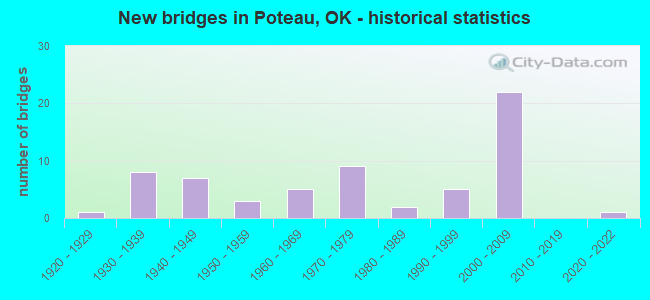
- New bridges - historical statistics
- 11920-1929
- 81930-1939
- 71940-1949
- 31950-1959
- 51960-1969
- 91970-1979
- 21980-1989
- 51990-1999
- 222000-2009
- 12020-2022
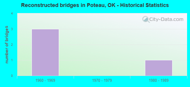
- Reconstructed bridges - Historical Statistics
- 31960-1969
- 01970-1979
- 11980-1989
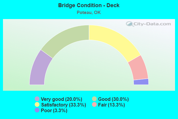
- Bridge Condition - Deck
- 20.0%Very good
- 30.0%Good
- 33.3%Satisfactory
- 13.3%Fair
- 3.3%Poor
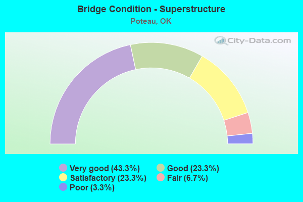
- Bridge Condition - Superstructure
- 43.3%Very good
- 23.3%Good
- 23.3%Satisfactory
- 6.7%Fair
- 3.3%Poor
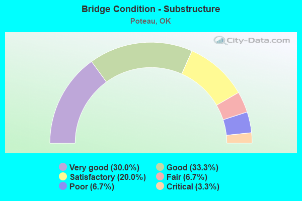
- Bridge Condition - Substructure
- 30.0%Very good
- 33.3%Good
- 20.0%Satisfactory
- 6.7%Fair
- 6.7%Poor
- 3.3%Critical
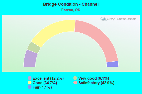
- Bridge Condition - Channel
- 12.2%Excellent
- 6.1%Very good
- 34.7%Good
- 42.9%Satisfactory
- 4.1%Fair
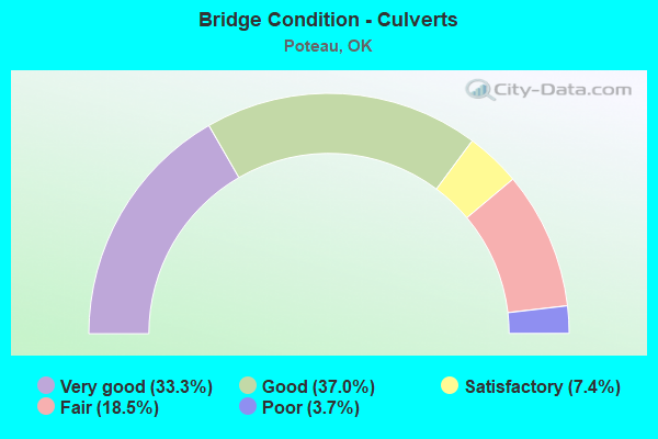
- Bridge Condition - Culverts
- 33.3%Very good
- 37.0%Good
- 7.4%Satisfactory
- 18.5%Fair
- 3.7%Poor
Find on map >> Show street view
Structure Number: 117, Location: 1.1E OF SHADYPOINT (Lat: 35.135689, Lng: -94.650614), Route carried "on" structure: County highway 1492, Year Built: 1920, Status: Closed, Structure Length: 10.67m (35.01ft), Average Daily Traffic: 175 (year 2020), Truck Traffic: 5%, Average Future Daily Traffic: 280 (year 2040), Design Load: H 10, Features Intersected: POTEAU RIVER
Minimum Vertical Clearance: 4.14m (13.58ft), Kilometerpoint: 0.000, Lanes on structure: 1, Owner: County Highway Agency, Approaching Roadway Width: 5.0m (16.4ft), Material/Design: Steel, Design/Construction: Truss - Thru, Number Of Spans In Main Unit: 1, Number Of Approach Spans: 2, Length of Maximum Span: 61.0m (200.1ft), Curb-To-Curb Width: 4.8m (15.7ft), Out-to-Out Width: 4.9m (16.1ft)
Condition: Deck: Poor, Superstructure: Fair, Substructure: Critical, Channel: Good, Waterway Adequacy: Equal to present minimum criteria, Approach Roadway Alignment: Equal to present minimum criteria, Bridge Posting: Required (Relationship of Operating Rating to Maximum Legal Load: > 39.9% below), Length Of Structure Improvement: 12.24m (40.16ft), Designated Inspection Frequency: Every 24 months, Inspection Date: January 2021, Bridge Improvement Cost: $313,000, Roadway Improvement Cost: $172,000, Total Project Cost: $499,000 ( Estimate for 2015), Deck Structure Type: Concrete Cast-file-Place, Wearing Surface/Protective System: Wearing Surface: Bituminous
Find on map >> Show street view
Structure Number: 5486, Location: 0.15 E JCT US-59 (Lat: 34.985664, Lng: -94.630833), Route carried "on" structure: State highway 83, Year Built: 1937, Status: Open, Structure Length: 3.87m (12.70ft), Average Daily Traffic: 2,600 (year 2020), Truck Traffic: 15%, Average Future Daily Traffic: 4,160 (year 2040), Design Load: H 20, Features Intersected: KANSAS CITY SOUTHERN R.R
Minimum Vertical Clearance: 30+ m (98+ ft), Kilometerpoint: 0.789, Lanes on structure: 2, Owner: State Highway Agency, Approaching Roadway Width: 9.8m (32.2ft), Material/Design: Steel, Design/Construction: Stringer/Multi-beam, Number Of Spans In Main Unit: 3, Length of Maximum Span: 13.4m (44.0ft), Curb or Sidewalk Widths: Left: 0.5m (1.6ft), Right: 0.5m (1.6ft), Curb-To-Curb Width: 7.3m (24.0ft), Out-to-Out Width: 8.2m (26.9ft)
Condition: Deck: Fair, Superstructure: Satisfactory, Substructure: Satisfactory, Operating Rating: 40.8 metric tons, Method Used To Determine Operating Rating: Load Factor (LF), Inventory Rating: 24.5 metric tons, Method Used To Determine Inventory Rating: Load Factor (LF), Structural Evaluation: Equal to present minimum criteria, Deck Geometry: High priority of replacement, Underclear: Meets minimum limits, Approach Roadway Alignment: Equal to present desirable criteria, Length Of Structure Improvement: 6.86m (22.51ft), Designated Inspection Frequency: Every 24 months, Inspection Date: June 2020, Bridge Improvement Cost: $579,000, Roadway Improvement Cost: $955,000, Total Project Cost: $1,620,000 ( Estimate for 2015), Deck Structure Type: Concrete Cast-file-Place, Wearing Surface/Protective System: Wearing Surface: Bituminous
Find on map >> Show street view
Structure Number: 6016, Location: 2.7W 1S OF HOWE (Lat: 34.936994, Lng: -94.693183), Route carried "on" structure: County highway 4028C, Year Built: 1938, Status: Open, Structure Length: 0.67m (2.20ft), Average Daily Traffic: 100 (year 2020), Truck Traffic: 15%, Average Future Daily Traffic: 160 (year 2040), Features Intersected: CREEK
Minimum Vertical Clearance: 30+ m (98+ ft), Kilometerpoint: 1.448, Lanes on structure: 2, Owner: County Highway Agency, Approaching Roadway Width: 5.5m (18.0ft), Material/Design: Concrete, Design/Construction: Slab, Number Of Spans In Main Unit: 2, Length of Maximum Span: 3.0m (9.8ft), Curb-To-Curb Width: 8.2m (26.9ft), Out-to-Out Width: 8.7m (28.5ft)
Condition: Deck: Satisfactory, Superstructure: Satisfactory, Substructure: Fair, Channel: Satisfactory, Operating Rating: 32.7 metric tons, Method Used To Determine Operating Rating: Load Factor (LF), Inventory Rating: 19.1 metric tons, Method Used To Determine Inventory Rating: Load Factor (LF), Structural Evaluation: Somewhat better than minimum adequacy, Deck Geometry: Equal to present minimum criteria, Waterway Adequacy: Better than present minimum criteria, Approach Roadway Alignment: Equal to present desirable criteria, Length Of Structure Improvement: 2.79m (9.15ft), Designated Inspection Frequency: Every 24 months, Inspection Date: March 2021, Bridge Improvement Cost: $143,000, Roadway Improvement Cost: $78,000, Total Project Cost: $225,000 ( Estimate for 2015), Deck Structure Type: Concrete Cast-file-Place, Wearing Surface/Protective System: Wearing Surface: Bituminous
Find on map >> Show street view
Structure Number: 6022, Location: 2.9N 2.2E OF HOWE (Lat: 34.993017, Lng: -94.599608), Route carried "on" structure: County highway E1395, Year Built: 1938, Status: Open, Structure Length: 0.73m (2.40ft), Average Daily Traffic: 24 (year 2020), Truck Traffic: 10%, Average Future Daily Traffic: 38 (year 2040), Features Intersected: CREEK
Minimum Vertical Clearance: 30+ m (98+ ft), Kilometerpoint: 1.127, Lanes on structure: 2, Owner: County Highway Agency, Approaching Roadway Width: 5.5m (18.0ft), Material/Design: Concrete, Design/Construction: Slab, Number Of Spans In Main Unit: 2, Length of Maximum Span: 3.0m (9.8ft), Curb-To-Curb Width: 6.7m (22.0ft), Out-to-Out Width: 7.3m (24.0ft)
Condition: Deck: Good, Superstructure: Good, Substructure: Very good, Channel: Satisfactory, Operating Rating: 32.7 metric tons, Method Used To Determine Operating Rating: Load Factor (LF), Inventory Rating: 19.1 metric tons, Method Used To Determine Inventory Rating: Load Factor (LF), Structural Evaluation: Somewhat better than minimum adequacy, Deck Geometry: Somewhat better than minimum adequacy, Waterway Adequacy: Equal to present minimum criteria, Approach Roadway Alignment: Equal to present desirable criteria, Length Of Structure Improvement: 2.92m (9.58ft), Designated Inspection Frequency: Every 24 months, Inspection Date: Febuary 2021, Bridge Improvement Cost: $149,000, Roadway Improvement Cost: $82,000, Total Project Cost: $236,000 ( Estimate for 2015), Deck Structure Type: Concrete Cast-file-Place, Wearing Surface/Protective System: Wearing Surface: Bituminous
Find on map >> Show street view
Structure Number: 611, Location: 2.7 N 1.0 E PANAMA (Lat: 35.214747, Lng: -94.655147), Route carried "on" structure: County highway 4013C, Year Built: 1938, Status: Open, Structure Length: 1.07m (3.51ft), Average Daily Traffic: 170 (year 2020), Truck Traffic: 10%, Average Future Daily Traffic: 272 (year 2040), Design Load: H 15, Features Intersected: HOLI-TUSHKA CREEK
Minimum Vertical Clearance: 30+ m (98+ ft), Kilometerpoint: 0.483, Lanes on structure: 2, Owner: County Highway Agency, Approaching Roadway Width: 6.7m (22.0ft), Material/Design: Concrete, Design/Construction: Culvert, Number Of Spans In Main Unit: 1, Length of Maximum Span: 9.8m (32.2ft), Curb-To-Curb Width: 7.6m (24.9ft), Out-to-Out Width: 8.2m (26.9ft)
Condition: Channel: Satisfactory, Culverts: Poor, Operating Rating: 32.7 metric tons, Method Used To Determine Operating Rating: Load Factor (LF), Inventory Rating: 19.1 metric tons, Method Used To Determine Inventory Rating: Load Factor (LF), Structural Evaluation: Meets minimum limits, Deck Geometry: Somewhat better than minimum adequacy, Waterway Adequacy: Better than present minimum criteria, Approach Roadway Alignment: Equal to present desirable criteria, Length Of Structure Improvement: 3.58m (11.75ft), Designated Inspection Frequency: Every 24 months, Inspection Date: Febuary 2021, Bridge Improvement Cost: $183,000, Roadway Improvement Cost: $100,000, Total Project Cost: $290,000 ( Estimate for 2015), Deck Structure Type: Concrete Cast-file-Place, Wearing Surface/Protective System: Wearing Surface: Bituminous
Find on map >> Show street view
Structure Number: 6125, Location: 5.5 W HEAVENER (Lat: 34.893647, Lng: -94.701308), Route carried "on" structure: County highway 4032C, Year Built: 1938, Status: Open, Structure Length: 0.91m (2.99ft), Average Daily Traffic: 300 (year 2020), Truck Traffic: 10%, Average Future Daily Traffic: 480 (year 2040), Features Intersected: CREEK
Minimum Vertical Clearance: 30+ m (98+ ft), Kilometerpoint: 57.924, Lanes on structure: 2, Owner: County Highway Agency, Approaching Roadway Width: 5.5m (18.0ft), Skew: 3 degrees, Material/Design: Concrete continuous, Design/Construction: Slab, Number Of Spans In Main Unit: 2, Length of Maximum Span: 3.7m (12.1ft), Curb-To-Curb Width: 5.9m (19.4ft), Out-to-Out Width: 6.6m (21.7ft)
Condition: Deck: Satisfactory, Superstructure: Satisfactory, Substructure: Very good, Channel: Satisfactory, Operating Rating: 32.7 metric tons, Method Used To Determine Operating Rating: Load Factor (LF), Inventory Rating: 19.1 metric tons, Method Used To Determine Inventory Rating: Load Factor (LF), Structural Evaluation: Somewhat better than minimum adequacy, Deck Geometry: High priority of corrective action, Waterway Adequacy: Equal to present minimum criteria, Approach Roadway Alignment: Equal to present desirable criteria, Length Of Structure Improvement: 3.28m (10.76ft), Designated Inspection Frequency: Every 24 months, Inspection Date: March 2021, Bridge Improvement Cost: $168,000, Roadway Improvement Cost: $92,000, Total Project Cost: $265,000 ( Estimate for 2015), Deck Structure Type: Concrete Cast-file-Place, Wearing Surface/Protective System: Wearing Surface: Bituminous
Find on map >> Show street view
Structure Number: 6476, Location: 3.2 E 1.4 N HOWE (Lat: 34.971153, Lng: -94.581703), Route carried "on" structure: County highway E1410, Year Built: 1938, Status: Open, Structure Length: 1.43m (4.69ft), Average Daily Traffic: 100 (year 2020), Truck Traffic: 10%, Average Future Daily Traffic: 160 (year 2040), Features Intersected: CREEK
Minimum Vertical Clearance: 30+ m (98+ ft), Kilometerpoint: 1.127, Lanes on structure: 2, Owner: County Highway Agency, Approaching Roadway Width: 5.5m (18.0ft), Skew: 6 degrees, Material/Design: Concrete, Design/Construction: Slab, Number Of Spans In Main Unit: 2, Length of Maximum Span: 5.5m (18.0ft), Curb-To-Curb Width: 6.1m (20.0ft), Out-to-Out Width: 7.0m (23.0ft)
Condition: Deck: Fair, Superstructure: Satisfactory, Substructure: Satisfactory, Channel: Fair, Operating Rating: 32.7 metric tons, Method Used To Determine Operating Rating: Load Factor (LF), Inventory Rating: 19.1 metric tons, Method Used To Determine Inventory Rating: Load Factor (LF), Structural Evaluation: Somewhat better than minimum adequacy, Deck Geometry: Somewhat better than minimum adequacy, Waterway Adequacy: Meets minimum limits, Approach Roadway Alignment: Equal to present minimum criteria, Length Of Structure Improvement: 4.17m (13.68ft), Designated Inspection Frequency: Every 24 months, Inspection Date: Febuary 2021, Bridge Improvement Cost: $213,000, Roadway Improvement Cost: $117,000, Total Project Cost: $339,000 ( Estimate for 2015), Deck Structure Type: Concrete Cast-file-Place, Wearing Surface/Protective System: Wearing Surface: Bituminous
Find on map >> Show street view
Structure Number: 6485, Location: 0.2 MI S OF ARMORY (Lat: 35.037250, Lng: -94.639567), Route carried "on" structure: City street N4714, Year Built: 1938, Status: Open, Structure Length: 1.34m (4.40ft), Average Daily Traffic: 1,500 (year 2020), Truck Traffic: 10%, Average Future Daily Traffic: 2,400 (year 2040), Design Load: H 10, Features Intersected: MCMURTREY CREEK
Minimum Vertical Clearance: 30+ m (98+ ft), Kilometerpoint: 0.322, Lanes on structure: 2, Owner: City or Municipal Highway Agency, Approaching Roadway Width: 7.3m (24.0ft), Material/Design: Concrete, Design/Construction: Slab, Number Of Spans In Main Unit: 2, Length of Maximum Span: 6.1m (20.0ft), Curb-To-Curb Width: 7.3m (24.0ft), Out-to-Out Width: 8.2m (26.9ft)
Condition: Deck: Satisfactory, Superstructure: Satisfactory, Substructure: Satisfactory, Channel: Satisfactory, Operating Rating: 32.7 metric tons, Method Used To Determine Operating Rating: Load Factor (LF), Inventory Rating: 19.1 metric tons, Method Used To Determine Inventory Rating: Load Factor (LF), Structural Evaluation: Somewhat better than minimum adequacy, Deck Geometry: Meets minimum limits, Waterway Adequacy: Equal to present desirable criteria, Approach Roadway Alignment: Equal to present desirable criteria, Length Of Structure Improvement: 5.15m (16.90ft), Designated Inspection Frequency: Every 24 months, Inspection Date: January 2021, Bridge Improvement Cost: $263,000, Roadway Improvement Cost: $145,000, Total Project Cost: $419,000 ( Estimate for 2015), Deck Structure Type: Concrete Cast-file-Place, Wearing Surface/Protective System: Wearing Surface: Bituminous
Find on map >> Show street view
Structure Number: 7095, Location: 3.4 W; 1.0 S HOWE (Lat: 34.936706, Lng: -94.697514), Route carried "on" structure: County highway 4028C, Year Built: 1939, Status: Open, Structure Length: 1.10m (3.61ft), Average Daily Traffic: 225 (year 2020), Truck Traffic: 15%, Average Future Daily Traffic: 360 (year 2040), Features Intersected: THOMPSON CREEK
Minimum Vertical Clearance: 30+ m (98+ ft), Kilometerpoint: 9.654, Lanes on structure: 2, Owner: County Highway Agency, Approaching Roadway Width: 7.3m (24.0ft), Material/Design: Concrete, Design/Construction: Slab, Number Of Spans In Main Unit: 3, Length of Maximum Span: 3.0m (9.8ft), Curb-To-Curb Width: 7.3m (24.0ft), Out-to-Out Width: 7.9m (25.9ft)
Condition: Deck: Satisfactory, Superstructure: Satisfactory, Substructure: Poor, Channel: Satisfactory, Operating Rating: 32.7 metric tons, Method Used To Determine Operating Rating: Load Factor (LF), Inventory Rating: 19.1 metric tons, Method Used To Determine Inventory Rating: Load Factor (LF), Structural Evaluation: Meets minimum limits, Deck Geometry: Somewhat better than minimum adequacy, Waterway Adequacy: Equal to present desirable criteria, Approach Roadway Alignment: Equal to present desirable criteria, Length Of Structure Improvement: 3.63m (11.91ft), Designated Inspection Frequency: Every 24 months, Inspection Date: Febuary 2021, Bridge Improvement Cost: $185,000, Roadway Improvement Cost: $102,000, Total Project Cost: $294,000 ( Estimate for 2015), Deck Structure Type: Concrete Cast-file-Place, Wearing Surface/Protective System: Wearing Surface: Bituminous
Find on map >> Show street view
Structure Number: 7585, Location: 2.0 W GILMORE (Lat: 35.048281, Lng: -94.558042), Route carried "on" structure: County highway 4066C, Year Built: 1940, Status: Open, Structure Length: 0.67m (2.20ft), Average Daily Traffic: 325 (year 2020), Truck Traffic: 15%, Average Future Daily Traffic: 520 (year 2040), Features Intersected: CREEK
Minimum Vertical Clearance: 30+ m (98+ ft), Kilometerpoint: 0.966, Lanes on structure: 2, Owner: County Highway Agency, Approaching Roadway Width: 6.1m (20.0ft), Material/Design: Concrete, Design/Construction: Slab, Number Of Spans In Main Unit: 2, Length of Maximum Span: 3.0m (9.8ft), Curb-To-Curb Width: 6.1m (20.0ft), Out-to-Out Width: 6.7m (22.0ft)
Condition: Deck: Satisfactory, Superstructure: Good, Substructure: Good, Channel: Good, Operating Rating: 32.7 metric tons, Method Used To Determine Operating Rating: Load Factor (LF), Inventory Rating: 19.1 metric tons, Method Used To Determine Inventory Rating: Load Factor (LF), Structural Evaluation: Somewhat better than minimum adequacy, Deck Geometry: Meets minimum limits, Waterway Adequacy: Equal to present minimum criteria, Approach Roadway Alignment: Equal to present desirable criteria, Length Of Structure Improvement: 2.79m (9.15ft), Designated Inspection Frequency: Every 24 months, Inspection Date: Febuary 2021, Bridge Improvement Cost: $143,000, Roadway Improvement Cost: $78,000, Total Project Cost: $225,000 ( Estimate for 2015), Deck Structure Type: Concrete Cast-file-Place, Wearing Surface/Protective System: Wearing Surface: Bituminous
Find on map >> Show street view
Structure Number: 9084, Location: 2.4 W 1.1 N MONROE (Lat: 35.010297, Lng: -94.557931), Route carried "on" structure: County highway N4760, Year Built: 1940, Year Reconstructed: 1987, Status: Open, Structure Length: 1.80m (5.91ft), Average Daily Traffic: 40 (year 2020), Truck Traffic: 10%, Average Future Daily Traffic: 64 (year 2040), Features Intersected: DOUBLE BRANCH CREEK
Minimum Vertical Clearance: 30+ m (98+ ft), Kilometerpoint: 0.644, Lanes on structure: 2, Owner: County Highway Agency, Approaching Roadway Width: 6.1m (20.0ft), Material/Design: Steel, Design/Construction: Stringer/Multi-beam, Number Of Spans In Main Unit: 2, Length of Maximum Span: 8.8m (28.9ft), Curb-To-Curb Width: 5.5m (18.0ft), Out-to-Out Width: 5.5m (18.0ft)
Condition: Deck: Satisfactory, Superstructure: Good, Substructure: Good, Channel: Good, Operating Rating: 52.6 metric tons, Method Used To Determine Operating Rating: Load Factor (LF), Inventory Rating: 31.8 metric tons, Method Used To Determine Inventory Rating: Load Factor (LF), Structural Evaluation: Better than present minimum criteria, Waterway Adequacy: Equal to present minimum criteria, Approach Roadway Alignment: Equal to present minimum criteria, Length Of Structure Improvement: 4.67m (15.32ft), Designated Inspection Frequency: Every 24 months, Inspection Date: Febuary 2021, Bridge Improvement Cost: $239,000, Roadway Improvement Cost: $131,000, Total Project Cost: $380,000 ( Estimate for 2015), Deck Structure Type: Wood or Timber, Wearing Surface/Protective System: Wearing Surface: Wood or Timber
Find on map >> Show street view
Structure Number: 9719, Location: 2.23 N JCT US-271 (Lat: 35.058819, Lng: -94.620169), Route carried "on" structure: US 59, Year Built: 1941, Year Reconstructed: 1973, Status: Open, Structure Length: 1.48m (4.86ft), Average Daily Traffic: 17,700 (year 2020), Truck Traffic: 7%, Average Future Daily Traffic: 28,320 (year 2040), Design Load: H 20, Features Intersected: TOWN CREEK
Minimum Vertical Clearance: 30+ m (98+ ft), Kilometerpoint: 3.587, Lanes on structure: 4, Base Highway Network: Yes, Owner: State Highway Agency, Approaching Roadway Width: 15.8m (51.8ft), Skew: 3 degrees, Material/Design: Concrete, Design/Construction: Culvert, Number Of Spans In Main Unit: 3, Length of Maximum Span: 4.3m (14.1ft), Curb or Sidewalk Widths: Left: 0.9m (3.0ft), Right: 0.9m (3.0ft), Curb-To-Curb Width: 17.1m (56.1ft), Out-to-Out Width: 17.7m (58.1ft)
Condition: Channel: Good, Culverts: Satisfactory, Operating Rating: 42.0 metric tons, Method Used To Determine Operating Rating: Load Factor (LF), Inventory Rating: 25.1 metric tons, Method Used To Determine Inventory Rating: Load Factor (LF), Structural Evaluation: Equal to present minimum criteria, Deck Geometry: Somewhat better than minimum adequacy, Waterway Adequacy: Equal to present desirable criteria, Approach Roadway Alignment: Equal to present desirable criteria, Length Of Structure Improvement: 1.16m (3.81ft), Designated Inspection Frequency: Every 24 months, Inspection Date: June 2020, Bridge Improvement Cost: $230,000, Roadway Improvement Cost: $380,000, Total Project Cost: $644,000 ( Estimate for 2015)
Find on map >> Show street view
Structure Number: 9726, Location: 6.80 N JCT US-271 (Lat: 35.115419, Lng: -94.650122), Route carried "on" structure: US 59, Year Built: 1941, Status: Open, Structure Length: 1.04m (3.41ft), Average Daily Traffic: 12,200 (year 2020), Truck Traffic: 16%, Average Future Daily Traffic: 19,520 (year 2040), Design Load: H 20, Features Intersected: CREEK
Minimum Vertical Clearance: 30+ m (98+ ft), Kilometerpoint: 10.940, Lanes on structure: 4, Base Highway Network: Yes, Owner: State Highway Agency, Approaching Roadway Width: 15.2m (49.9ft), Skew: 10 degrees, Material/Design: Concrete, Design/Construction: Culvert, Number Of Spans In Main Unit: 3, Length of Maximum Span: 3.0m (9.8ft), Curb or Sidewalk Widths: Left: 0.3m (1.0ft), Right: 0.3m (1.0ft), Curb-To-Curb Width: 46.3m (151.9ft), Out-to-Out Width: 46.9m (153.9ft)
Condition: Channel: Very good, Culverts: Good, Operating Rating: 40.8 metric tons, Method Used To Determine Operating Rating: Load Factor (LF), Inventory Rating: 24.4 metric tons, Method Used To Determine Inventory Rating: Load Factor (LF), Structural Evaluation: Equal to present minimum criteria, Deck Geometry: Superior to present desirable criteria, Waterway Adequacy: Equal to present desirable criteria, Approach Roadway Alignment: Equal to present desirable criteria, Length Of Structure Improvement: 1.04m (3.41ft), Designated Inspection Frequency: Every 24 months, Inspection Date: June 2020, Bridge Improvement Cost: $318,000, Roadway Improvement Cost: $525,000, Total Project Cost: $892,000 ( Estimate for 2015)
Find on map >> Show street view
Structure Number: 977, Location: 5.73 N JCT US-271 (Lat: 35.105189, Lng: -94.638394), Route carried "on" structure: US 59, Year Built: 1941, Year Reconstructed: 1973, Status: Open, Structure Length: 0.70m (2.30ft), Average Daily Traffic: 12,200 (year 2020), Truck Traffic: 16%, Average Future Daily Traffic: 19,520 (year 2040), Design Load: H 20, Features Intersected: CREEK
Minimum Vertical Clearance: 30+ m (98+ ft), Kilometerpoint: 9.220, Lanes on structure: 4, Base Highway Network: Yes, Owner: State Highway Agency, Approaching Roadway Width: 15.2m (49.9ft), Skew: 10 degrees, Material/Design: Concrete, Design/Construction: Culvert, Number Of Spans In Main Unit: 2, Length of Maximum Span: 3.0m (9.8ft), Curb or Sidewalk Widths: Left: 0.3m (1.0ft), Right: 0.3m (1.0ft), Curb-To-Curb Width: 41.8m (137.1ft), Out-to-Out Width: 42.4m (139.1ft)
Condition: Channel: Good, Culverts: Good, Operating Rating: 44.5 metric tons, Method Used To Determine Operating Rating: Allowable Stress (AS), Inventory Rating: 32.7 metric tons, Method Used To Determine Inventory Rating: Allowable Stress (AS), Structural Evaluation: Better than present minimum criteria, Deck Geometry: Superior to present desirable criteria, Waterway Adequacy: Equal to present desirable criteria, Approach Roadway Alignment: Equal to present desirable criteria, Length Of Structure Improvement: 0.64m (2.10ft), Designated Inspection Frequency: Every 24 months, Inspection Date: June 2020, Bridge Improvement Cost: $230,000, Roadway Improvement Cost: $380,000, Total Project Cost: $644,000 ( Estimate for 2015)
Find on map >> Show street view
Structure Number: 9788, Location: 4.18 N JCT US-271 (Lat: 35.084467, Lng: -94.629900), Route carried "on" structure: US 59, Year Built: 1941, Year Reconstructed: 1973, Status: Open, Structure Length: 1.66m (5.45ft), Average Daily Traffic: 15,700 (year 2020), Truck Traffic: 7%, Average Future Daily Traffic: 25,120 (year 2040), Design Load: H 20, Features Intersected: POLK CREEK
Minimum Vertical Clearance: 30+ m (98+ ft), Kilometerpoint: 6.725, Lanes on structure: 4, Base Highway Network: Yes, Owner: State Highway Agency, Approaching Roadway Width: 14.0m (45.9ft), Skew: 3 degrees, Material/Design: Concrete, Design/Construction: Culvert, Number Of Spans In Main Unit: 3, Length of Maximum Span: 5.2m (17.1ft), Curb or Sidewalk Widths: Left: 0.3m (1.0ft), Right: 0.3m (1.0ft), Curb-To-Curb Width: 18.3m (60.0ft), Out-to-Out Width: 18.9m (62.0ft)
Condition: Channel: Good, Culverts: Satisfactory, Operating Rating: 37.6 metric tons, Method Used To Determine Operating Rating: Load Factor (LF), Inventory Rating: 22.6 metric tons, Method Used To Determine Inventory Rating: Load Factor (LF), Structural Evaluation: Somewhat better than minimum adequacy, Deck Geometry: Somewhat better than minimum adequacy, Waterway Adequacy: Equal to present desirable criteria, Approach Roadway Alignment: Equal to present desirable criteria, Length Of Structure Improvement: 1.65m (5.41ft), Designated Inspection Frequency: Every 24 months, Inspection Date: June 2020, Bridge Improvement Cost: $262,000, Roadway Improvement Cost: $432,000, Total Project Cost: $733,000 ( Estimate for 2015)
Find on map >> Show street view
Structure Number: 11027, Location: .55 MI E OF FRONT ST (Lat: 35.048325, Lng: -94.616708), Route carried "on" structure: City street 1446, Year Built: 1949, Status: Open, Structure Length: 0.79m (2.59ft), Average Daily Traffic: 475 (year 2020), Truck Traffic: 15%, Average Future Daily Traffic: 760 (year 2040), Design Load: H 20, Features Intersected: TOWN CREEK
Minimum Vertical Clearance: 30+ m (98+ ft), Kilometerpoint: 0.885, Lanes on structure: 2, Owner: City or Municipal Highway Agency, Approaching Roadway Width: 9.8m (32.2ft), Skew: 3 degrees, Material/Design: Concrete, Design/Construction: Culvert, Number Of Spans In Main Unit: 3, Length of Maximum Span: 2.4m (7.9ft), Curb or Sidewalk Widths: Left: 2.4m (7.9ft), Right: 2.4m (7.9ft), Curb-To-Curb Width: 14.6m (47.9ft), Out-to-Out Width: 15.2m (49.9ft)
Condition: Channel: Satisfactory, Culverts: Good, Operating Rating: 32.7 metric tons, Method Used To Determine Operating Rating: Load Factor (LF), Inventory Rating: 19.1 metric tons, Method Used To Determine Inventory Rating: Load Factor (LF), Structural Evaluation: Somewhat better than minimum adequacy, Deck Geometry: Superior to present desirable criteria, Waterway Adequacy: Equal to present desirable criteria, Approach Roadway Alignment: Equal to present desirable criteria, Length Of Structure Improvement: 3.05m (10.01ft), Designated Inspection Frequency: Every 24 months, Inspection Date: January 2021, Bridge Improvement Cost: $100,000, Roadway Improvement Cost: $75,000, Total Project Cost: $225,000 ( Estimate for 2015), Deck Structure Type: Concrete Cast-file-Place, Wearing Surface/Protective System: Wearing Surface: Monolithic Concrete
Find on map >> Show street view
Structure Number: 12847, Location: 3.0 MI S OF US 271 (Lat: 34.992850, Lng: -94.642861), Route carried "on" structure: City street E1395, Year Built: 1952, Status: Posted for load, Structure Length: 10.27m (33.69ft), Average Daily Traffic: 100 (year 2020), Truck Traffic: 5%, Average Future Daily Traffic: 160 (year 2040), Design Load: H 15, Features Intersected: POTEAU RIVER
Minimum Vertical Clearance: 4.88m (16.01ft), Kilometerpoint: 0.483, Lanes on structure: 2, Owner: City or Municipal Highway Agency, Approaching Roadway Width: 6.1m (20.0ft), Material/Design: Steel, Design/Construction: Truss - Thru, Number Of Spans In Main Unit: 1, Number Of Approach Spans: 2, Length of Maximum Span: 64.0m (210.0ft), Curb-To-Curb Width: 5.5m (18.0ft), Out-to-Out Width: 5.8m (19.0ft)
Condition: Deck: Fair, Superstructure: Poor, Substructure: Satisfactory, Channel: Satisfactory, Operating Rating: 24.1 metric tons, Method Used To Determine Operating Rating: Allowable Stress (AS), Inventory Rating: 9.3 metric tons, Method Used To Determine Inventory Rating: Allowable Stress (AS), Structural Evaluation: High priority of replacement, Deck Geometry: Meets minimum limits, Waterway Adequacy: Better than present minimum criteria, Approach Roadway Alignment: Equal to present desirable criteria, Bridge Posting: Required (Relationship of Operating Rating to Maximum Legal Load: 30.0 - 39.9% below), Length Of Structure Improvement: 11.86m (38.91ft), Designated Inspection Frequency: Every 24 months, Critical Feature Inspection Frequency: Every 24 months, Other Special Inspection Frequency: Every 24 months, Inspection Date: May 2021, Critical Feature Inspection Date: May 2021, Other Special Inspection Date: May 2021, Bridge Improvement Cost: $606,000, Roadway Improvement Cost: $333,000, Total Project Cost: $949,000 ( Estimate for 2015), Deck Structure Type: Concrete Cast-file-Place
Find on map >> Show street view
Structure Number: 1297, Location: SE EDGE OF POTEAU (Lat: 35.037675, Lng: -94.621517), Route carried "on" structure: City street 1459, Year Built: 1953, Status: Open, Structure Length: 1.46m (4.79ft), Average Daily Traffic: 200 (year 2020), Truck Traffic: 5%, Average Future Daily Traffic: 320 (year 2040), Design Load: H 15, Features Intersected: MCMURTREY CREEK
Minimum Vertical Clearance: 30+ m (98+ ft), Kilometerpoint: 0.966, Lanes on structure: 1, Owner: City or Municipal Highway Agency, Approaching Roadway Width: 4.9m (16.1ft), Material/Design: Concrete, Design/Construction: Slab, Number Of Spans In Main Unit: 3, Length of Maximum Span: 4.6m (15.1ft), Curb-To-Curb Width: 4.9m (16.1ft), Out-to-Out Width: 5.2m (17.1ft)
Condition: Deck: Satisfactory, Superstructure: Satisfactory, Substructure: Poor, Channel: Satisfactory, Operating Rating: 32.7 metric tons, Method Used To Determine Operating Rating: Load Factor (LF), Inventory Rating: 19.1 metric tons, Method Used To Determine Inventory Rating: Load Factor (LF), Structural Evaluation: Meets minimum limits, Deck Geometry: High priority of replacement, Waterway Adequacy: Equal to present minimum criteria, Approach Roadway Alignment: Equal to present desirable criteria, Length Of Structure Improvement: 4.22m (13.85ft), Designated Inspection Frequency: Every 24 months, Inspection Date: January 2021, Bridge Improvement Cost: $215,000, Roadway Improvement Cost: $118,000, Total Project Cost: $342,000 ( Estimate for 2015), Deck Structure Type: Concrete Cast-file-Place, Wearing Surface/Protective System: Wearing Surface: Bituminous
Find on map >> Show street view
Structure Number: 13184, Location: .8 MI N OF DEWEY AVE (Lat: 35.058925, Lng: -94.612050), Route carried "on" structure: City street E1349, Year Built: 1954, Status: Open, Structure Length: 1.40m (4.59ft), Average Daily Traffic: 1,000 (year 2020), Truck Traffic: 5%, Average Future Daily Traffic: 1,600 (year 2040), Design Load: H 20, Features Intersected: CREEK, Facility Carried by Structure: FAU 1455 (WITTE ST
Minimum Vertical Clearance: 30+ m (98+ ft), Kilometerpoint: 1.287, Lanes on structure: 2, Owner: City or Municipal Highway Agency, Approaching Roadway Width: 7.3m (24.0ft), Skew: 3 degrees, Material/Design: Concrete, Design/Construction: Culvert, Number Of Spans In Main Unit: 3, Length of Maximum Span: 4.9m (16.1ft), Curb-To-Curb Width: 9.1m (29.9ft), Out-to-Out Width: 9.8m (32.2ft)
Condition: Channel: Satisfactory, Culverts: Fair, Operating Rating: 32.7 metric tons, Method Used To Determine Operating Rating: Load Factor (LF), Inventory Rating: 19.1 metric tons, Method Used To Determine Inventory Rating: Load Factor (LF), Structural Evaluation: Somewhat better than minimum adequacy, Deck Geometry: Equal to present minimum criteria, Waterway Adequacy: Equal to present desirable criteria, Approach Roadway Alignment: Equal to present desirable criteria, Length Of Structure Improvement: 4.12m (13.52ft), Designated Inspection Frequency: Every 24 months, Inspection Date: January 2021, Bridge Improvement Cost: $100,000, Roadway Improvement Cost: $75,000, Total Project Cost: $225,000 ( Estimate for 2015)
Find on map >> Show street view
Structure Number: 14722, Location: 3.0 E; 1.4 N WISTER (Lat: 34.985583, Lng: -94.685953), Route carried "on" structure: County highway E1400, Year Built: 1960, Status: Open, Structure Length: 0.70m (2.30ft), Average Daily Traffic: 200 (year 2020), Truck Traffic: 10%, Average Future Daily Traffic: 320 (year 2040), Design Load: HS 20, Features Intersected: CREEK
Minimum Vertical Clearance: 30+ m (98+ ft), Kilometerpoint: 1.287, Lanes on structure: 2, Owner: County Highway Agency, Approaching Roadway Width: 6.1m (20.0ft), Material/Design: Concrete, Design/Construction: Culvert, Number Of Spans In Main Unit: 2, Length of Maximum Span: 3.0m (9.8ft), Curb-To-Curb Width: 9.1m (29.9ft), Out-to-Out Width: 9.8m (32.2ft)
Condition: Channel: Satisfactory, Culverts: Fair, Operating Rating: 32.7 metric tons, Method Used To Determine Operating Rating: Load Factor (LF), Inventory Rating: 19.1 metric tons, Method Used To Determine Inventory Rating: Load Factor (LF), Structural Evaluation: Somewhat better than minimum adequacy, Deck Geometry: Equal to present minimum criteria, Waterway Adequacy: Better than present minimum criteria, Approach Roadway Alignment: Equal to present desirable criteria, Length Of Structure Improvement: 2.72m (8.92ft), Designated Inspection Frequency: Every 24 months, Inspection Date: January 2021, Bridge Improvement Cost: $100,000, Roadway Improvement Cost: $75,000, Total Project Cost: $225,000 ( Estimate for 2015)
Find on map >> Show street view
Structure Number: 14859, Location: 0.5 MI.N.COGGINS ST. (Lat: 35.080128, Lng: -94.619367), Route carried "on" structure: City street E1335, Year Built: 2002, Status: Open, Structure Length: 1.05m (3.44ft), Average Daily Traffic: 300 (year 2020), Truck Traffic: 10%, Average Future Daily Traffic: 480 (year 2040), Design Load: HS 20, Features Intersected: POLK CREEK, Facility Carried by Structure: POSUM VALLEY RD
Minimum Vertical Clearance: 30+ m (98+ ft), Kilometerpoint: 0.161, Lanes on structure: 2, Owner: City or Municipal Highway Agency, Approaching Roadway Width: 6.4m (21.0ft), Material/Design: Concrete, Design/Construction: Culvert, Number Of Spans In Main Unit: 3, Length of Maximum Span: 3.0m (9.8ft), Curb-To-Curb Width: 12.2m (40.0ft), Out-to-Out Width: 12.8m (42.0ft)
Condition: Channel: Satisfactory, Culverts: Very good, Operating Rating: 32.7 metric tons, Method Used To Determine Operating Rating: Load Factor (LF), Inventory Rating: 19.1 metric tons, Method Used To Determine Inventory Rating: Load Factor (LF), Structural Evaluation: Somewhat better than minimum adequacy, Deck Geometry: Superior to present desirable criteria, Waterway Adequacy: Equal to present desirable criteria, Approach Roadway Alignment: Equal to present desirable criteria, Length Of Structure Improvement: 3.41m (11.19ft), Designated Inspection Frequency: Every 24 months, Inspection Date: January 2021, Bridge Improvement Cost: $100,000, Roadway Improvement Cost: $75,000, Total Project Cost: $225,000 ( Estimate for 2015)
Find on map >> Show street view
Structure Number: 14893, Location: .25 MI.N. URBAN LIMITS (Lat: 35.033447, Lng: -94.628981), Route carried "on" structure: City street 1451, Year Built: 1960, Status: Open, Structure Length: 1.43m (4.69ft), Average Daily Traffic: 1,000 (year 2020), Truck Traffic: 15%, Average Future Daily Traffic: 1,600 (year 2040), Design Load: H 20, Features Intersected: CREEK
Minimum Vertical Clearance: 30+ m (98+ ft), Kilometerpoint: 0.402, Lanes on structure: 2, Owner: City or Municipal Highway Agency, Approaching Roadway Width: 7.3m (24.0ft), Material/Design: Concrete, Design/Construction: Culvert, Number Of Spans In Main Unit: 3, Length of Maximum Span: 4.3m (14.1ft), Curb-To-Curb Width: 8.5m (27.9ft), Out-to-Out Width: 9.1m (29.9ft)
Condition: Channel: Satisfactory, Culverts: Good, Operating Rating: 32.7 metric tons, Method Used To Determine Operating Rating: Load Factor (LF), Inventory Rating: 19.1 metric tons, Method Used To Determine Inventory Rating: Load Factor (LF), Structural Evaluation: Somewhat better than minimum adequacy, Deck Geometry: Somewhat better than minimum adequacy, Waterway Adequacy: Equal to present desirable criteria, Approach Roadway Alignment: Equal to present desirable criteria, Length Of Structure Improvement: 4.17m (13.68ft), Designated Inspection Frequency: Every 24 months, Inspection Date: January 2021, Bridge Improvement Cost: $100,000, Roadway Improvement Cost: $75,000, Total Project Cost: $225,000 ( Estimate for 2015)
Find on map >> Show street view
Structure Number: 14951, Location: 3.7 E; 1.4 N WISTER (Lat: 34.985606, Lng: -94.674264), Route carried "on" structure: County highway E1400, Year Built: 1960, Status: Open, Structure Length: 1.31m (4.30ft), Average Daily Traffic: 250 (year 2020), Truck Traffic: 10%, Average Future Daily Traffic: 400 (year 2040), Design Load: HS 20, Features Intersected: CREEK
Minimum Vertical Clearance: 30+ m (98+ ft), Kilometerpoint: 0.805, Lanes on structure: 2, Owner: County Highway Agency, Approaching Roadway Width: 6.1m (20.0ft), Material/Design: Concrete, Design/Construction: Culvert, Number Of Spans In Main Unit: 3, Length of Maximum Span: 4.0m (13.1ft), Curb-To-Curb Width: 9.1m (29.9ft), Out-to-Out Width: 9.8m (32.2ft)
Condition: Channel: Satisfactory, Culverts: Fair, Operating Rating: 32.7 metric tons, Method Used To Determine Operating Rating: Load Factor (LF), Inventory Rating: 19.1 metric tons, Method Used To Determine Inventory Rating: Load Factor (LF), Structural Evaluation: Somewhat better than minimum adequacy, Deck Geometry: Equal to present minimum criteria, Waterway Adequacy: Better than present minimum criteria, Approach Roadway Alignment: Equal to present desirable criteria, Length Of Structure Improvement: 3.88m (12.73ft), Designated Inspection Frequency: Every 24 months, Inspection Date: January 2021, Bridge Improvement Cost: $100,000, Roadway Improvement Cost: $75,000, Total Project Cost: $225,000 ( Estimate for 2015)
Find on map >> Show street view
Structure Number: 15036, Location: .35 MI.N. URBAN LIMITS (Lat: 35.035825, Lng: -94.628986), Route carried "on" structure: City street 1451, Year Built: 1960, Status: Open, Structure Length: 2.29m (7.51ft), Average Daily Traffic: 1,000 (year 2020), Truck Traffic: 15%, Average Future Daily Traffic: 1,600 (year 2040), Design Load: H 20, Features Intersected: MCMURTREY CREEK
Minimum Vertical Clearance: 30+ m (98+ ft), Kilometerpoint: 0.724, Lanes on structure: 2, Owner: City or Municipal Highway Agency, Approaching Roadway Width: 7.3m (24.0ft), Skew: 3 degrees, Material/Design: Concrete, Design/Construction: Culvert, Number Of Spans In Main Unit: 4, Length of Maximum Span: 6.1m (20.0ft), Curb-To-Curb Width: 8.5m (27.9ft), Out-to-Out Width: 9.1m (29.9ft)
Condition: Channel: Satisfactory, Culverts: Good, Operating Rating: 32.7 metric tons, Method Used To Determine Operating Rating: Load Factor (LF), Inventory Rating: 19.1 metric tons, Method Used To Determine Inventory Rating: Load Factor (LF), Structural Evaluation: Somewhat better than minimum adequacy, Deck Geometry: Somewhat better than minimum adequacy, Waterway Adequacy: Equal to present desirable criteria, Approach Roadway Alignment: Equal to present desirable criteria, Length Of Structure Improvement: 5.35m (17.55ft), Designated Inspection Frequency: Every 24 months, Inspection Date: January 2021, Bridge Improvement Cost: $100,000, Roadway Improvement Cost: $75,000, Total Project Cost: $225,000 ( Estimate for 2015)
Find on map >> Show street view
Structure Number: 16859, Location: 0.2 MI S OLD SH 112 (Lat: 35.058242, Lng: -94.610503), Route carried "on" structure: City street 1461, Year Built: 1967, Status: Open, Structure Length: 0.98m (3.22ft), Average Daily Traffic: 1,000 (year 2020), Truck Traffic: 15%, Average Future Daily Traffic: 1,600 (year 2040), Design Load: HS 20, Features Intersected: CREEK, Facility Carried by Structure: INDUSTRIAL BLVD.
Minimum Vertical Clearance: 30+ m (98+ ft), Kilometerpoint: 1.127, Lanes on structure: 2, Owner: City or Municipal Highway Agency, Approaching Roadway Width: 7.3m (24.0ft), Material/Design: Concrete, Design/Construction: Culvert, Number Of Spans In Main Unit: 3, Length of Maximum Span: 3.0m (9.8ft), Curb-To-Curb Width: 9.8m (32.2ft), Out-to-Out Width: 10.4m (34.1ft)
Condition: Channel: Satisfactory, Culverts: Fair, Operating Rating: 32.7 metric tons, Method Used To Determine Operating Rating: Load Factor (LF), Inventory Rating: 19.1 metric tons, Method Used To Determine Inventory Rating: Load Factor (LF), Structural Evaluation: Somewhat better than minimum adequacy, Deck Geometry: Equal to present minimum criteria, Waterway Adequacy: Equal to present desirable criteria, Approach Roadway Alignment: Equal to present desirable criteria, Length Of Structure Improvement: 3.41m (11.19ft), Designated Inspection Frequency: Every 24 months, Inspection Date: January 2021, Bridge Improvement Cost: $100,000, Roadway Improvement Cost: $75,000, Total Project Cost: $225,000 ( Estimate for 2015)
Find on map >> Show street view
Structure Number: 177, Location: 9.54 N JCT US-270 (Lat: 35.019281, Lng: -94.646353), Route carried "on" structure: US 59, Year Built: 1970, Status: Open, Structure Length: 0.85m (2.79ft), Average Daily Traffic: 9,700 (year 2020), Truck Traffic: 16%, Average Future Daily Traffic: 15,520 (year 2040), Design Load: HS 20, Features Intersected: CREEK
Minimum Vertical Clearance: 30+ m (98+ ft), Kilometerpoint: 15.350, Lanes on structure: 2, Base Highway Network: Yes, Owner: State Highway Agency, Approaching Roadway Width: 12.2m (40.0ft), Material/Design: Concrete, Design/Construction: Culvert, Number Of Spans In Main Unit: 3, Length of Maximum Span: 2.4m (7.9ft), Curb or Sidewalk Widths: Left: 0.3m (1.0ft), Right: 0.3m (1.0ft), Curb-To-Curb Width: 25.6m (84.0ft), Out-to-Out Width: 26.2m (86.0ft)
Condition: Channel: Good, Culverts: Good, Operating Rating: 55.4 metric tons, Method Used To Determine Operating Rating: Load Factor (LF), Inventory Rating: 33.2 metric tons, Method Used To Determine Inventory Rating: Load Factor (LF), Structural Evaluation: Better than present minimum criteria, Deck Geometry: Superior to present desirable criteria, Waterway Adequacy: Equal to present desirable criteria, Approach Roadway Alignment: Equal to present desirable criteria, Length Of Structure Improvement: 0.79m (2.59ft), Designated Inspection Frequency: Every 24 months, Inspection Date: June 2020, Bridge Improvement Cost: $230,000, Roadway Improvement Cost: $380,000, Total Project Cost: $644,000 ( Estimate for 2015)
Find on map >> Show street view
Structure Number: 17896, Location: 2.08 NE JCT US-271 (Lat: 35.112842, Lng: -94.602075), Route carried "on" structure: State highway 112, Year Built: 1970, Status: Open, Structure Length: 4.63m (15.19ft), Average Daily Traffic: 8,900 (year 2020), Truck Traffic: 15%, Average Future Daily Traffic: 14,240 (year 2040), Design Load: HS 20, Features Intersected: POTEAU RIVER O'FLOW
Minimum Vertical Clearance: 30+ m (98+ ft), Kilometerpoint: 3.347, Lanes on structure: 2, Owner: State Highway Agency, Approaching Roadway Width: 13.4m (44.0ft), Material/Design: Steel, Design/Construction: Stringer/Multi-beam, Number Of Spans In Main Unit: 3, Length of Maximum Span: 15.2m (49.9ft), Curb or Sidewalk Widths: Left: 0.8m (2.6ft), Right: 0.8m (2.6ft), Curb-To-Curb Width: 13.4m (44.0ft), Out-to-Out Width: 14.9m (48.9ft)
Condition: Deck: Satisfactory, Superstructure: Good, Substructure: Good, Channel: Good, Operating Rating: 59.0 metric tons, Method Used To Determine Operating Rating: Load Factor (LF), Inventory Rating: 35.4 metric tons, Method Used To Determine Inventory Rating: Load Factor (LF), Structural Evaluation: Better than present minimum criteria, Deck Geometry: Equal to present minimum criteria, Waterway Adequacy: Equal to present desirable criteria, Approach Roadway Alignment: Equal to present desirable criteria, Length Of Structure Improvement: 7.75m (25.43ft), Designated Inspection Frequency: Every 24 months, Inspection Date: June 2020, Bridge Improvement Cost: $1,116,000, Roadway Improvement Cost: $1,841,000, Total Project Cost: $3,125,000 ( Estimate for 2015), Deck Structure Type: Concrete Cast-file-Place, Wearing Surface/Protective System: Wearing Surface: Monolithic Concrete
Find on map >> Show street view
Structure Number: 17948, Location: 1.7 MI NE JCT US59 (Lat: 35.109589, Lng: -94.607500), Route carried "on" structure: State highway 112, Year Built: 1970, Status: Open, Structure Length: 11.64m (38.19ft), Average Daily Traffic: 8,900 (year 2020), Truck Traffic: 15%, Average Future Daily Traffic: 14,240 (year 2040), Design Load: HS 20, Features Intersected: POTEAU RIVER
Minimum Vertical Clearance: 30+ m (98+ ft), Kilometerpoint: 2.623, Lanes on structure: 2, Owner: State Highway Agency, Approaching Roadway Width: 13.4m (44.0ft), Material/Design: Steel continuous, Design/Construction: Stringer/Multi-beam, Number Of Spans In Main Unit: 3, Number Of Approach Spans: 2, Length of Maximum Span: 30.5m (100.1ft), Curb or Sidewalk Widths: Left: 0.5m (1.6ft), Right: 0.5m (1.6ft), Curb-To-Curb Width: 8.5m (27.9ft), Out-to-Out Width: 10.1m (33.1ft)
Condition: Deck: Fair, Superstructure: Fair, Substructure: Fair, Channel: Satisfactory, Operating Rating: 50.8 metric tons, Method Used To Determine Operating Rating: Load Factor (LF), Inventory Rating: 30.8 metric tons, Method Used To Determine Inventory Rating: Load Factor (LF), Structural Evaluation: Somewhat better than minimum adequacy, Deck Geometry: Meets minimum limits, Waterway Adequacy: Equal to present minimum criteria, Approach Roadway Alignment: Equal to present desirable criteria, Length Of Structure Improvement: 12.67m (41.57ft), Designated Inspection Frequency: Every 24 months, Inspection Date: December 2020, Bridge Improvement Cost: $1,704,000, Roadway Improvement Cost: $2,811,000, Total Project Cost: $4,771,000 ( Estimate for 2015), Deck Structure Type: Concrete Cast-file-Place, Wearing Surface/Protective System: Wearing Surface: Monolithic Concrete
Find on map >> Show street view
Structure Number: 18015, Location: 0.39 N JCT US-271 (Lat: 35.039181, Lng: -94.641344), Route carried "on" structure: US 59, Year Built: 1971, Status: Open, Structure Length: 1.98m (6.50ft), Average Daily Traffic: 8,500 (year 2020), Truck Traffic: 7%, Average Future Daily Traffic: 13,600 (year 2040), Design Load: HS 20, Features Intersected: MCMURTREY CREEK
Minimum Vertical Clearance: 30+ m (98+ ft), Kilometerpoint: 0.628, Lanes on structure: 2, Base Highway Network: Yes, Owner: State Highway Agency, Approaching Roadway Width: 13.4m (44.0ft), Material/Design: Concrete, Design/Construction: Culvert, Number Of Spans In Main Unit: 4, Length of Maximum Span: 5.2m (17.1ft), Curb or Sidewalk Widths: Left: 0.3m (1.0ft), Right: 0.3m (1.0ft), Curb-To-Curb Width: 25.6m (84.0ft), Out-to-Out Width: 26.2m (86.0ft)
Condition: Channel: Good, Culverts: Very good, Operating Rating: 76.0 metric tons, Method Used To Determine Operating Rating: Load Factor (LF), Inventory Rating: 45.5 metric tons, Method Used To Determine Inventory Rating: Load Factor (LF), Structural Evaluation: Equal to present desirable criteria, Deck Geometry: Superior to present desirable criteria, Waterway Adequacy: Equal to present desirable criteria, Approach Roadway Alignment: Equal to present desirable criteria, Length Of Structure Improvement: 1.95m (6.40ft), Designated Inspection Frequency: Every 24 months, Inspection Date: June 2020, Bridge Improvement Cost: $367,000, Roadway Improvement Cost: $606,000, Total Project Cost: $1,028,000 ( Estimate for 2015)
Find on map >> Show street view
Structure Number: 1865, Location: 1.96 E JCT US-59 (Lat: 34.985669, Lng: -94.604575), Route carried "on" structure: State highway 83, Year Built: 1974, Status: Open, Structure Length: 1.22m (4.00ft), Average Daily Traffic: 2,200 (year 2020), Truck Traffic: 15%, Average Future Daily Traffic: 3,520 (year 2040), Design Load: HS 20, Features Intersected: CREEK
Minimum Vertical Clearance: 30+ m (98+ ft), Kilometerpoint: 3.154, Lanes on structure: 2, Owner: State Highway Agency, Approaching Roadway Width: 8.5m (27.9ft), Material/Design: Concrete, Design/Construction: Culvert, Number Of Spans In Main Unit: 3, Length of Maximum Span: 3.7m (12.1ft), Curb or Sidewalk Widths: Left: 0.3m (1.0ft), Right: 0.3m (1.0ft), Curb-To-Curb Width: 12.2m (40.0ft), Out-to-Out Width: 12.8m (42.0ft)
Condition: Channel: Good, Culverts: Good, Operating Rating: 44.7 metric tons, Method Used To Determine Operating Rating: Allowable Stress (AS), Inventory Rating: 26.8 metric tons, Method Used To Determine Inventory Rating: Allowable Stress (AS), Structural Evaluation: Equal to present minimum criteria, Deck Geometry: Equal to present minimum criteria, Waterway Adequacy: Equal to present desirable criteria, Approach Roadway Alignment: Equal to present desirable criteria, Length Of Structure Improvement: 1.19m (3.90ft), Designated Inspection Frequency: Every 24 months, Inspection Date: June 2020, Bridge Improvement Cost: $230,000, Roadway Improvement Cost: $380,000, Total Project Cost: $644,000 ( Estimate for 2015)
Find on map >> Show street view
Structure Number: 18704, Location: 3.30 E JCT US-59 (Lat: 34.985658, Lng: -94.581194), Route carried "on" structure: State highway 83, Year Built: 1974, Status: Open, Structure Length: 1.98m (6.50ft), Average Daily Traffic: 2,200 (year 2020), Truck Traffic: 15%, Average Future Daily Traffic: 3,520 (year 2040), Design Load: HS 20, Features Intersected: HORSE PEN CREEK
Minimum Vertical Clearance: 30+ m (98+ ft), Kilometerpoint: 5.309, Lanes on structure: 2, Owner: State Highway Agency, Approaching Roadway Width: 8.5m (27.9ft), Material/Design: Concrete, Design/Construction: Culvert, Number Of Spans In Main Unit: 4, Length of Maximum Span: 4.6m (15.1ft), Curb or Sidewalk Widths: Left: 0.3m (1.0ft), Right: 0.3m (1.0ft), Curb-To-Curb Width: 12.2m (40.0ft), Out-to-Out Width: 12.8m (42.0ft)
Condition: Channel: Good, Culverts: Good, Operating Rating: 37.8 metric tons, Method Used To Determine Operating Rating: Allowable Stress (AS), Inventory Rating: 22.7 metric tons, Method Used To Determine Inventory Rating: Allowable Stress (AS), Structural Evaluation: Equal to present minimum criteria, Deck Geometry: Equal to present minimum criteria, Waterway Adequacy: Equal to present desirable criteria, Approach Roadway Alignment: Equal to present desirable criteria, Length Of Structure Improvement: 1.95m (6.40ft), Designated Inspection Frequency: Every 24 months, Inspection Date: June 2020, Bridge Improvement Cost: $266,000, Roadway Improvement Cost: $439,000, Total Project Cost: $745,000 ( Estimate for 2015)
Find on map >> Show street view
Structure Number: 19218, Location: 8.09 N JCT US-270 (Lat: 34.998639, Lng: -94.646164), Route carried "on" structure: US 59, Year Built: 1976, Status: Open, Structure Length: 3.72m (12.20ft), Average Daily Traffic: 9,900 (year 2020), Truck Traffic: 16%, Average Future Daily Traffic: 15,840 (year 2040), Design Load: HS 20, Features Intersected: POTEAU RIVER O'FLOW
Minimum Vertical Clearance: 30+ m (98+ ft), Kilometerpoint: 20.949, Lanes on structure: 2, Base Highway Network: Yes, Owner: State Highway Agency, Approaching Roadway Width: 13.4m (44.0ft), Material/Design: Prestressed concrete, Design/Construction: Stringer/Multi-beam, Number Of Spans In Main Unit: 3, Length of Maximum Span: 12.2m (40.0ft), Curb or Sidewalk Widths: Left: 0.5m (1.6ft), Right: 0.5m (1.6ft), Curb-To-Curb Width: 14.2m (46.6ft), Out-to-Out Width: 15.1m (49.5ft)
Condition: Deck: Good, Superstructure: Good, Substructure: Satisfactory, Channel: Excellent, Operating Rating: 36.3 metric tons, Method Used To Determine Operating Rating: Load Factor (LF), Inventory Rating: 21.8 metric tons, Method Used To Determine Inventory Rating: Load Factor (LF), Structural Evaluation: Somewhat better than minimum adequacy, Deck Geometry: Superior to present desirable criteria, Waterway Adequacy: Superior to present desirable criteria, Approach Roadway Alignment: Equal to present desirable criteria, Length Of Structure Improvement: 6.92m (22.70ft), Designated Inspection Frequency: Every 24 months, Inspection Date: June 2020, Bridge Improvement Cost: $1,013,000, Roadway Improvement Cost: $1,672,000, Total Project Cost: $2,837,000 ( Estimate for 2015), Deck Structure Type: Concrete Cast-file-Place, Wearing Surface/Protective System: Wearing Surface: Monolithic Concrete, Membrane: Preformed Fabric
Find on map >> Show street view
Structure Number: 19265, Location: 7.46 N JCT US-270 (Lat: 34.990733, Lng: -94.643367), Route carried "on" structure: US 59, Year Built: 1976, Status: Open, Structure Length: 10.73m (35.20ft), Average Daily Traffic: 9,900 (year 2020), Truck Traffic: 16%, Average Future Daily Traffic: 15,840 (year 2040), Design Load: HS 20, Features Intersected: POTEAU RIVER
Minimum Vertical Clearance: 30+ m (98+ ft), Kilometerpoint: 12.002, Lanes on structure: 2, Base Highway Network: Yes, Owner: State Highway Agency, Approaching Roadway Width: 13.4m (44.0ft), Material/Design: Prestressed concrete, Design/Construction: Stringer/Multi-beam, Number Of Spans In Main Unit: 4, Length of Maximum Span: 30.5m (100.1ft), Curb or Sidewalk Widths: Left: 0.5m (1.6ft), Right: 0.5m (1.6ft), Curb-To-Curb Width: 14.2m (46.6ft), Out-to-Out Width: 15.1m (49.5ft)
Condition: Deck: Good, Superstructure: Good, Substructure: Good, Channel: Satisfactory, Operating Rating: 38.1 metric tons, Method Used To Determine Operating Rating: Load Factor (LF), Inventory Rating: 22.7 metric tons, Method Used To Determine Inventory Rating: Load Factor (LF), Structural Evaluation: Somewhat better than minimum adequacy, Deck Geometry: Superior to present desirable criteria, Waterway Adequacy: Superior to present desirable criteria, Approach Roadway Alignment: Equal to present desirable criteria, Length Of Structure Improvement: 12.14m (39.83ft), Designated Inspection Frequency: Every 24 months, Inspection Date: June 2020, Bridge Improvement Cost: $1,642,000, Roadway Improvement Cost: $2,709,000, Total Project Cost: $4,597,000 ( Estimate for 2015), Deck Structure Type: Concrete Cast-file-Place, Wearing Surface/Protective System: Wearing Surface: Monolithic Concrete, Membrane: Preformed Fabric
Find on map >> Show street view
Structure Number: 19266, Location: 8.37 N JCT US-270 (Lat: 35.000228, Lng: -94.645722), Route carried "on" structure: US 59, Year Built: 1976, Status: Open, Structure Length: 10.73m (35.20ft), Average Daily Traffic: 9,700 (year 2020), Truck Traffic: 16%, Average Future Daily Traffic: 15,520 (year 2040), Design Load: HS 20, Features Intersected: LONG LAKE
Minimum Vertical Clearance: 30+ m (98+ ft), Kilometerpoint: 21.673, Lanes on structure: 2, Base Highway Network: Yes, Owner: State Highway Agency, Approaching Roadway Width: 13.4m (44.0ft), Skew: 3 degrees, Material/Design: Prestressed concrete, Design/Construction: Stringer/Multi-beam, Number Of Spans In Main Unit: 6, Length of Maximum Span: 30.5m (100.1ft), Curb or Sidewalk Widths: Left: 0.5m (1.6ft), Right: 0.5m (1.6ft), Curb-To-Curb Width: 14.2m (46.6ft), Out-to-Out Width: 15.1m (49.5ft)
Condition: Deck: Satisfactory, Superstructure: Good, Substructure: Satisfactory, Channel: Excellent, Operating Rating: 37.2 metric tons, Method Used To Determine Operating Rating: Load Factor (LF), Inventory Rating: 22.7 metric tons, Method Used To Determine Inventory Rating: Load Factor (LF), Structural Evaluation: Somewhat better than minimum adequacy, Deck Geometry: Superior to present desirable criteria, Waterway Adequacy: Superior to present desirable criteria, Approach Roadway Alignment: Equal to present desirable criteria, Length Of Structure Improvement: 12.14m (39.83ft), Designated Inspection Frequency: Every 24 months, Inspection Date: June 2020, Bridge Improvement Cost: $1,642,000, Roadway Improvement Cost: $2,709,000, Total Project Cost: $4,597,000 ( Estimate for 2015), Deck Structure Type: Concrete Cast-file-Place, Wearing Surface/Protective System: Wearing Surface: Monolithic Concrete, Membrane: Preformed Fabric
Find on map >> Show street view
Structure Number: 21379, Location: 4.6 S SPIRO (Lat: 35.174133, Lng: -94.611353), Route carried "on" structure: County highway N4730, Year Built: 1987, Status: Open, Structure Length: 0.70m (2.30ft), Average Daily Traffic: 30 (year 2020), Truck Traffic: 10%, Average Future Daily Traffic: 48 (year 2040), Design Load: HS 20, Features Intersected: CREEK
Minimum Vertical Clearance: 30+ m (98+ ft), Kilometerpoint: 0.322, Lanes on structure: 2, Owner: County Highway Agency, Approaching Roadway Width: 5.5m (18.0ft), Material/Design: Concrete, Design/Construction: Culvert, Number Of Spans In Main Unit: 2, Length of Maximum Span: 3.0m (9.8ft), Curb-To-Curb Width: 9.1m (29.9ft), Out-to-Out Width: 9.8m (32.2ft)
Condition: Channel: Fair, Culverts: Very good, Operating Rating: 54.4 metric tons, Method Used To Determine Operating Rating: Load Factor (LF), Inventory Rating: 32.7 metric tons, Method Used To Determine Inventory Rating: Load Factor (LF), Structural Evaluation: Equal to present desirable criteria, Deck Geometry: Better than present minimum criteria, Waterway Adequacy: Better than present minimum criteria, Approach Roadway Alignment: Equal to present desirable criteria, Length Of Structure Improvement: 2.72m (8.92ft), Designated Inspection Frequency: Every 24 months, Inspection Date: January 2021, Bridge Improvement Cost: $100,000, Roadway Improvement Cost: $75,000, Total Project Cost: $225,000 ( Estimate for 2015)
Find on map >> Show street view
Structure Number: 21439, Location: 0.5 N; 0.6 W US271/SH112 (Lat: 35.101800, Lng: -94.642053), Route carried "on" structure: County highway E1320, Year Built: 1987, Status: Open, Structure Length: 0.81m (2.66ft), Average Daily Traffic: 150 (year 2020), Truck Traffic: 10%, Average Future Daily Traffic: 240 (year 2040), Design Load: HS 20, Features Intersected: CREEK
Minimum Vertical Clearance: 30+ m (98+ ft), Kilometerpoint: 0.161, Lanes on structure: 2, Owner: County Highway Agency, Approaching Roadway Width: 7.3m (24.0ft), Skew: 3 degrees, Material/Design: Concrete, Design/Construction: Culvert, Number Of Spans In Main Unit: 2, Length of Maximum Span: 3.5m (11.5ft), Curb-To-Curb Width: 9.1m (29.9ft), Out-to-Out Width: 9.8m (32.2ft)
Condition: Channel: Good, Culverts: Very good, Operating Rating: 44.5 metric tons, Method Used To Determine Operating Rating: Load Factor (LF), Inventory Rating: 32.7 metric tons, Method Used To Determine Inventory Rating: Load Factor (LF), Structural Evaluation: Equal to present desirable criteria, Deck Geometry: Equal to present minimum criteria, Waterway Adequacy: Superior to present desirable criteria, Approach Roadway Alignment: Equal to present desirable criteria, Length Of Structure Improvement: 2.92m (9.58ft), Designated Inspection Frequency: Every 24 months, Inspection Date: January 2021, Bridge Improvement Cost: $100,000, Roadway Improvement Cost: $75,000, Total Project Cost: $225,000 ( Estimate for 2015)
Find on map >> Show street view
Structure Number: 22945, Location: 1.5 MI E OF PANAMA (Lat: 35.165617, Lng: -94.652831), Route carried "on" structure: City street 1494, Year Built: 1991, Status: Open, Structure Length: 18.29m (60.01ft), Average Daily Traffic: 300 (year 2020), Truck Traffic: 5%, Average Future Daily Traffic: 480 (year 2040), Design Load: HS 20, Features Intersected: POTEAU RIVER
Minimum Vertical Clearance: 30+ m (98+ ft), Kilometerpoint: 0.966, Lanes on structure: 2, Owner: City or Municipal Highway Agency, Approaching Roadway Width: 6.1m (20.0ft), Material/Design: Prestressed concrete, Design/Construction: Stringer/Multi-beam, Number Of Spans In Main Unit: 6, Length of Maximum Span: 30.5m (100.1ft), Curb-To-Curb Width: 7.9m (25.9ft), Out-to-Out Width: 8.5m (27.9ft)
Condition: Deck: Satisfactory, Superstructure: Very good, Substructure: Good, Channel: Satisfactory, Operating Rating: 98.0 metric tons, Method Used To Determine Operating Rating: Load Factor (LF), Inventory Rating: 85.3 metric tons, Method Used To Determine Inventory Rating: Load Factor (LF), Structural Evaluation: Better than present minimum criteria, Deck Geometry: Somewhat better than minimum adequacy, Waterway Adequacy: Somewhat better than minimum adequacy, Approach Roadway Alignment: Equal to present desirable criteria, Length Of Structure Improvement: 18.29m (60.01ft), Designated Inspection Frequency: Every 24 months, Inspection Date: January 2021, Bridge Improvement Cost: $934,000, Roadway Improvement Cost: $480,000, Total Project Cost: $1,439,000 ( Estimate for 2015), Deck Structure Type: Concrete Cast-file-Place, Wearing Surface/Protective System: Wearing Surface: Monolithic Concrete
Find on map >> Show street view
Structure Number: 23343, Location: 2.3 W; 1.4 N GILMORE (Lat: 35.072697, Lng: -94.563278), Route carried "on" structure: County highway 4031, Year Built: 1991, Status: Open, Structure Length: 3.12m (10.24ft), Average Daily Traffic: 650 (year 2020), Truck Traffic: 15%, Average Future Daily Traffic: 1,040 (year 2040), Design Load: HS 20, Features Intersected: NAIL CREEK, Facility Carried by Structure: 4024C
Minimum Vertical Clearance: 30+ m (98+ ft), Kilometerpoint: 3.380, Lanes on structure: 2, Owner: County Highway Agency, Approaching Roadway Width: 7.3m (24.0ft), Material/Design: Prestressed concrete, Design/Construction: Stringer/Multi-beam, Number Of Spans In Main Unit: 1, Length of Maximum Span: 30.5m (100.1ft), Curb-To-Curb Width: 9.8m (32.2ft), Out-to-Out Width: 10.4m (34.1ft)
Condition: Deck: Very good, Superstructure: Very good, Substructure: Very good, Channel: Very good, Operating Rating: 90.7 metric tons, Method Used To Determine Operating Rating: Load Factor (LF), Inventory Rating: 43.8 metric tons, Method Used To Determine Inventory Rating: Load Factor (LF), Structural Evaluation: Equal to present desirable criteria, Deck Geometry: Equal to present minimum criteria, Waterway Adequacy: Equal to present desirable criteria, Approach Roadway Alignment: Equal to present desirable criteria, Length Of Structure Improvement: 6.23m (20.44ft), Designated Inspection Frequency: Every 24 months, Inspection Date: Febuary 2021, Bridge Improvement Cost: $318,000, Roadway Improvement Cost: $175,000, Total Project Cost: $508,000 ( Estimate for 2015), Deck Structure Type: Concrete Cast-file-Place, Wearing Surface/Protective System: Wearing Surface: Monolithic Concrete
Find on map >> Show street view
Structure Number: 23344, Location: 0.7 S; 1.4 E POTEAU (Lat: 35.043872, Lng: -94.649133), Route carried "on" structure: County highway 4090C, Year Built: 1993, Status: Open, Structure Length: 1.98m (6.50ft), Average Daily Traffic: 400 (year 2020), Truck Traffic: 15%, Average Future Daily Traffic: 640 (year 2040), Design Load: HS 20, Features Intersected: MCMURTREY CREEK
Minimum Vertical Clearance: 30+ m (98+ ft), Kilometerpoint: 3.219, Lanes on structure: 2, Owner: County Highway Agency, Approaching Roadway Width: 6.1m (20.0ft), Skew: 4 degrees, Material/Design: Concrete, Design/Construction: Culvert, Number Of Spans In Main Unit: 3, Length of Maximum Span: 7.0m (23.0ft), Curb-To-Curb Width: 12.8m (42.0ft), Out-to-Out Width: 13.4m (44.0ft)
Condition: Channel: Good, Culverts: Fair, Operating Rating: 32.7 metric tons, Method Used To Determine Operating Rating: Load Factor (LF), Inventory Rating: 19.1 metric tons, Method Used To Determine Inventory Rating: Load Factor (LF), Structural Evaluation: Somewhat better than minimum adequacy, Deck Geometry: Superior to present desirable criteria, Waterway Adequacy: Equal to present minimum criteria, Approach Roadway Alignment: Equal to present desirable criteria, Length Of Structure Improvement: 4.96m (16.27ft), Designated Inspection Frequency: Every 24 months, Inspection Date: January 2021, Bridge Improvement Cost: $100,000, Roadway Improvement Cost: $75,000, Total Project Cost: $225,000 ( Estimate for 2015)
Find on map >> Show street view
Structure Number: 25657, Location: 0.20 E JCT US-271 (Lat: 35.096589, Lng: -94.628761), Route carried "on" structure: State highway 112, Year Built: 2000, Status: Open, Structure Length: 6.19m (20.31ft), Average Daily Traffic: 4,650 (year 2020), Truck Traffic: 16%, Average Future Daily Traffic: 7,440 (year 2040), Design Load: HS 20, Features Intersected: KANSAS CITY SOUTHERN R.R
Minimum Vertical Clearance: 30+ m (98+ ft), Kilometerpoint: 0.322, Lanes on structure: 2, Base Highway Network: Yes, Owner: State Highway Agency, Approaching Roadway Width: 11.4m (37.4ft), Material/Design: Prestressed concrete, Design/Construction: Stringer/Multi-beam, Number Of Spans In Main Unit: 3, Length of Maximum Span: 24.1m (79.1ft), Curb or Sidewalk Widths: Left: 0.5m (1.6ft), Right: 0.5m (1.6ft), Curb-To-Curb Width: 11.4m (37.4ft), Out-to-Out Width: 12.3m (40.4ft)
Condition: Deck: Good, Superstructure: Very good, Substructure: Good, Operating Rating: 79.8 metric tons, Method Used To Determine Operating Rating: Load Factor (LF), Inventory Rating: 46.3 metric tons, Method Used To Determine Inventory Rating: Load Factor (LF), Structural Evaluation: Better than present minimum criteria, Deck Geometry: Equal to present minimum criteria, Underclear: Superior to present desirable criteria, Approach Roadway Alignment: Equal to present desirable criteria, Length Of Structure Improvement: 6.91m (22.67ft), Designated Inspection Frequency: Every 24 months, Inspection Date: June 2020, Bridge Improvement Cost: $582,000, Roadway Improvement Cost: $961,000, Total Project Cost: $1,631,000 ( Estimate for 2015), Deck Structure Type: Concrete Cast-file-Place, Wearing Surface/Protective System: Wearing Surface: Monolithic Concrete, Membrane: Preformed Fabric, Deck Protection: Epoxy Coated Reinforcing