Bridge Statistics for Pasadena, Texas (TX)
Condition, Traffic, Stress, Structural Evaluation, Project Costs
- National Bridge Inventory (NBI) Statistics
- 201Number of bridges
- 3,878ft / 1,182mTotal length
- $3,962,000Total costs
- 3,776,878Total average daily traffic
- 269,263Total average daily truck traffic
- National Bridge Inventory (NBI) Registered Bridges for Pasadena
- No street view available for this location
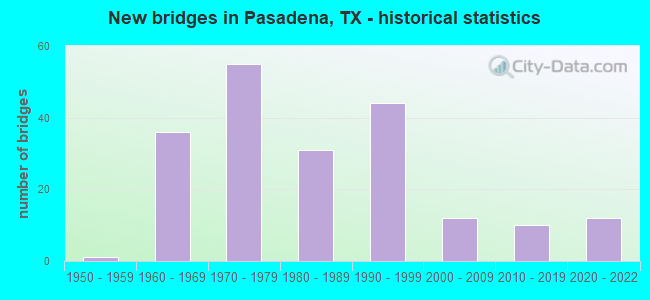
- New bridges - historical statistics
- 11950-1959
- 361960-1969
- 551970-1979
- 311980-1989
- 441990-1999
- 122000-2009
- 102010-2019
- 122020-2022
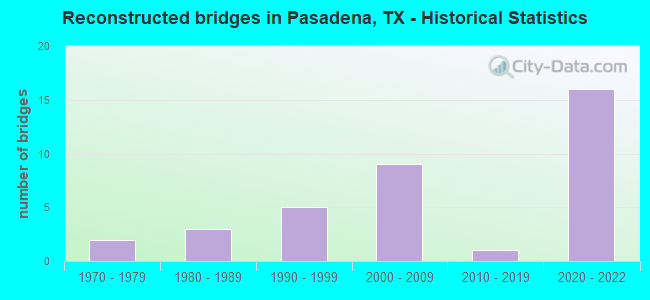
- Reconstructed bridges - Historical Statistics
- 21970-1979
- 31980-1989
- 51990-1999
- 92000-2009
- 12010-2019
- 162020-2022
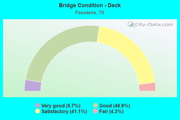
- Bridge Condition - Deck
- 5.7%Very good
- 48.9%Good
- 41.1%Satisfactory
- 4.3%Fair
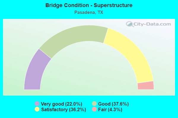
- Bridge Condition - Superstructure
- 22.0%Very good
- 37.6%Good
- 36.2%Satisfactory
- 4.3%Fair
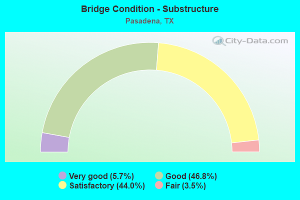
- Bridge Condition - Substructure
- 5.7%Very good
- 46.8%Good
- 44.0%Satisfactory
- 3.5%Fair
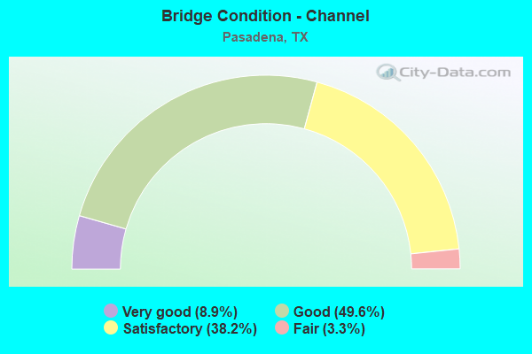
- Bridge Condition - Channel
- 8.9%Very good
- 49.6%Good
- 38.2%Satisfactory
- 3.3%Fair
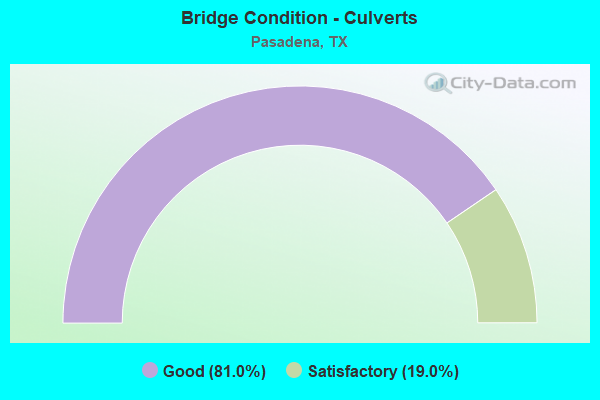
- Bridge Condition - Culverts
- 81.0%Good
- 19.0%Satisfactory
Find on map >> Show street view
Structure Number: 121020098101023, Location: 3.4 MI NE OF SH 3 (Lat: 29.563711, Lng: -95.070892), Route carried "on" structure: State highway 1, Year Built: 1998, Status: Open, Structure Length: 42.37m (139.01ft), Average Daily Traffic: 32,000 (year 2010), Truck Traffic: 4%, Average Future Daily Traffic: 36,400 (year 2030), Design Load: HS 20, Features Intersected: MUD / CLEAR LAKE
Minimum Vertical Clearance: 30+ m (98+ ft), Kilometerpoint: 0.002, Lanes on structure: 6, Owner: State Highway Agency, Approaching Roadway Width: 21.3m (69.9ft), Material/Design: Prestressed concrete, Design/Construction: Slab, Number Of Spans In Main Unit: 28, Length of Maximum Span: 15.2m (49.9ft), Curb or Sidewalk Widths: Left: 1.8m (5.9ft), Right: 1.9m (6.2ft), Curb-To-Curb Width: 21.3m (69.9ft), Out-to-Out Width: 24.0m (78.7ft)
Condition: Deck: Good, Superstructure: Good, Substructure: Fair, Channel: Fair, Operating Rating: 54.4 metric tons, Method Used To Determine Operating Rating: Assigned rating based on Load Factor Design (LFD) reported in metric tons, Inventory Rating: 32.7 metric tons, Method Used To Determine Inventory Rating: Assigned rating based on Load Factor Design (LFD) reported in metric tons, Structural Evaluation: Somewhat better than minimum adequacy, Deck Geometry: High priority of replacement, Waterway Adequacy: Superior to present desirable criteria, Approach Roadway Alignment: Equal to present desirable criteria, Length Of Structure Improvement: 42.37m (139.01ft), Designated Inspection Frequency: Every 24 months, Inspection Date: November 2020, Bridge Improvement Cost: $195,000, Roadway Improvement Cost: $49,000, Total Project Cost: $244,000, Deck Structure Type: Concrete Cast-file-Place
Find on map >> Show street view
Structure Number: 121020325603018, Location: 3.0 MI S OF SH 225 (Lat: 29.668661, Lng: -95.156286), Route carried "on" structure: ServiceState highway 8, Year Built: 1970, Status: Open, Structure Length: 2.07m (6.79ft), Average Daily Traffic: 12,356 (year 2020), Truck Traffic: 7%, Average Future Daily Traffic: 23,380 (year 2033), Features Intersected: LITTLE VINCE BAYOU
Minimum Vertical Clearance: 30+ m (98+ ft), Kilometerpoint: 32.148, Lanes on structure: 3, Owner: State Highway Agency, Approaching Roadway Width: 10.1m (33.1ft), Skew: 4 degrees, Material/Design: Concrete continuous, Design/Construction: Slab, Number Of Spans In Main Unit: 3, Length of Maximum Span: 7.0m (23.0ft), Curb-To-Curb Width: 10.1m (33.1ft), Out-to-Out Width: 11.6m (38.1ft)
Condition: Deck: Satisfactory, Superstructure: Satisfactory, Substructure: Satisfactory, Channel: Good, Operating Rating: 43.5 metric tons, Method Used To Determine Operating Rating: Load Factor (LF), Inventory Rating: 26.3 metric tons, Method Used To Determine Inventory Rating: Load Factor (LF), Structural Evaluation: Equal to present minimum criteria, Deck Geometry: High priority of replacement, Waterway Adequacy: Superior to present desirable criteria, Approach Roadway Alignment: Equal to present desirable criteria, Length Of Structure Improvement: 2.10m (6.89ft), Designated Inspection Frequency: Every 24 months, Inspection Date: September 2020, Bridge Improvement Cost: $5,000, Roadway Improvement Cost: $1,000, Total Project Cost: $6,000, Deck Structure Type: Concrete Cast-file-Place
Find on map >> Show street view
Structure Number: 121020325603019, Location: 3.0 MI S OF SH 225 (Lat: 29.668675, Lng: -95.155961), Route carried "on" structure: ServiceState highway 8, Year Built: 1970, Status: Open, Structure Length: 2.07m (6.79ft), Average Daily Traffic: 15,860 (year 2013), Truck Traffic: 7%, Average Future Daily Traffic: 22,210 (year 2033), Features Intersected: LITTLE VINCE BAYOU
Minimum Vertical Clearance: 30+ m (98+ ft), Kilometerpoint: 32.089, Lanes on structure: 3, Owner: State Highway Agency, Approaching Roadway Width: 10.1m (33.1ft), Skew: 4 degrees, Material/Design: Concrete continuous, Design/Construction: Slab, Number Of Spans In Main Unit: 3, Length of Maximum Span: 7.0m (23.0ft), Curb-To-Curb Width: 10.1m (33.1ft), Out-to-Out Width: 11.6m (38.1ft)
Condition: Deck: Satisfactory, Superstructure: Satisfactory, Substructure: Satisfactory, Channel: Good, Operating Rating: 44.4 metric tons, Method Used To Determine Operating Rating: Load Factor (LF), Inventory Rating: 26.3 metric tons, Method Used To Determine Inventory Rating: Load Factor (LF), Structural Evaluation: Equal to present minimum criteria, Deck Geometry: High priority of replacement, Waterway Adequacy: Superior to present desirable criteria, Approach Roadway Alignment: Equal to present desirable criteria, Length Of Structure Improvement: 2.10m (6.89ft), Designated Inspection Frequency: Every 24 months, Inspection Date: September 2020, Bridge Improvement Cost: $5,000, Roadway Improvement Cost: $1,000, Total Project Cost: $6,000, Deck Structure Type: Concrete Cast-file-Place
Find on map >> Show street view
Structure Number: 12102032560303, Location: 4.7 MI NE OF IH 45 (S) (Lat: 29.653700, Lng: -95.156628), Route carried "on" structure: ServiceState highway 8, Year Built: 1970, Status: Open, Structure Length: 3.41m (11.19ft), Average Daily Traffic: 12,356 (year 2020), Truck Traffic: 7%, Average Future Daily Traffic: 22,210 (year 2033), Design Load: H 20, Features Intersected: ARMAND BAYOU
Minimum Vertical Clearance: 30+ m (98+ ft), Kilometerpoint: 33.671, Lanes on structure: 2, Owner: State Highway Agency, Approaching Roadway Width: 10.1m (33.1ft), Skew: 4 degrees, Material/Design: Prestressed concrete, Design/Construction: Stringer/Multi-beam, Number Of Spans In Main Unit: 1, Number Of Approach Spans: 2, Length of Maximum Span: 15.9m (52.2ft), Curb or Sidewalk Widths: Left: 1.1m (3.6ft), Right: 1.1m (3.6ft), Curb-To-Curb Width: 9.5m (31.2ft), Out-to-Out Width: 12.8m (42.0ft)
Condition: Deck: Satisfactory, Superstructure: Satisfactory, Substructure: Satisfactory, Channel: Satisfactory, Operating Rating: 63.5 metric tons, Method Used To Determine Operating Rating: Load Factor (LF), Inventory Rating: 22.7 metric tons, Method Used To Determine Inventory Rating: Load Factor (LF), Structural Evaluation: Somewhat better than minimum adequacy, Deck Geometry: Meets minimum limits, Waterway Adequacy: Superior to present desirable criteria, Approach Roadway Alignment: Equal to present desirable criteria, Length Of Structure Improvement: 3.41m (11.19ft), Designated Inspection Frequency: Every 24 months, Inspection Date: August 2020, Bridge Improvement Cost: $7,000, Roadway Improvement Cost: $2,000, Total Project Cost: $9,000, Deck Structure Type: Concrete Cast-file-Place
Find on map >> Show street view
Structure Number: 121020325603031, Location: 4.7 MI NE OF IH 45 (S) (Lat: 29.653717, Lng: -95.156150), Route carried "on" structure: ServiceState highway 8, Year Built: 1970, Status: Open, Structure Length: 3.41m (11.19ft), Average Daily Traffic: 17,791 (year 2019), Truck Traffic: 7%, Average Future Daily Traffic: 23,380 (year 2033), Design Load: H 20, Features Intersected: ARMAND BAYOU
Minimum Vertical Clearance: 30+ m (98+ ft), Kilometerpoint: 33.671, Lanes on structure: 2, Owner: State Highway Agency, Approaching Roadway Width: 10.1m (33.1ft), Skew: 4 degrees, Material/Design: Prestressed concrete, Design/Construction: Stringer/Multi-beam, Number Of Spans In Main Unit: 1, Number Of Approach Spans: 2, Length of Maximum Span: 15.9m (52.2ft), Curb or Sidewalk Widths: Left: 1.1m (3.6ft), Right: 1.1m (3.6ft), Curb-To-Curb Width: 9.4m (30.8ft), Out-to-Out Width: 12.8m (42.0ft)
Condition: Deck: Satisfactory, Superstructure: Satisfactory, Substructure: Satisfactory, Channel: Satisfactory, Operating Rating: 63.5 metric tons, Method Used To Determine Operating Rating: Load Factor (LF), Inventory Rating: 22.7 metric tons, Method Used To Determine Inventory Rating: Load Factor (LF), Structural Evaluation: Somewhat better than minimum adequacy, Deck Geometry: Meets minimum limits, Waterway Adequacy: Superior to present desirable criteria, Approach Roadway Alignment: Equal to present desirable criteria, Length Of Structure Improvement: 3.41m (11.19ft), Designated Inspection Frequency: Every 24 months, Inspection Date: August 2020, Bridge Improvement Cost: $7,000, Roadway Improvement Cost: $2,000, Total Project Cost: $9,000, Deck Structure Type: Concrete Cast-file-Place
Find on map >> Show street view
Structure Number: 121020325603032, Location: 3.6 MI S OF SH 225 (Lat: 29.659828, Lng: -95.156592), Route carried "on" structure: ServiceState highway 8, Year Built: 1970, Status: Open, Structure Length: 2.19m (7.19ft), Average Daily Traffic: 12,356 (year 2020), Truck Traffic: 7%, Average Future Daily Traffic: 22,210 (year 2033), Design Load: HS 20, Features Intersected: ARMAND RELIEF
Minimum Vertical Clearance: 30+ m (98+ ft), Kilometerpoint: 33.135, Lanes on structure: 3, Owner: State Highway Agency, Maintenance Responsibility: Local Toll Authority, Approaching Roadway Width: 10.1m (33.1ft), Material/Design: Prestressed concrete, Design/Construction: Stringer/Multi-beam, Number Of Spans In Main Unit: 1, Length of Maximum Span: 21.9m (71.9ft), Curb or Sidewalk Widths: Left: 1.1m (3.6ft), Right: 1.1m (3.6ft), Curb-To-Curb Width: 10.1m (33.1ft), Out-to-Out Width: 12.7m (41.7ft)
Condition: Deck: Satisfactory, Superstructure: Good, Substructure: Satisfactory, Channel: Good, Operating Rating: 68.0 metric tons, Method Used To Determine Operating Rating: Load Factor (LF), Inventory Rating: 23.6 metric tons, Method Used To Determine Inventory Rating: Load Factor (LF), Structural Evaluation: Somewhat better than minimum adequacy, Deck Geometry: High priority of replacement, Waterway Adequacy: Superior to present desirable criteria, Approach Roadway Alignment: Equal to present desirable criteria, Length Of Structure Improvement: 2.19m (7.19ft), Designated Inspection Frequency: Every 24 months, Inspection Date: October 2020, Bridge Improvement Cost: $5,000, Roadway Improvement Cost: $1,000, Total Project Cost: $6,000, Deck Structure Type: Concrete Cast-file-Place
Find on map >> Show street view
Structure Number: 121020325603033, Location: 3.6 MI S OF SH 225 (Lat: 29.659803, Lng: -95.155844), Route carried "on" structure: ServiceState highway 8, Year Built: 1970, Status: Open, Structure Length: 2.19m (7.19ft), Average Daily Traffic: 16,700 (year 2013), Truck Traffic: 7%, Average Future Daily Traffic: 23,380 (year 2033), Design Load: HS 20, Features Intersected: ARMAND RELIEF
Minimum Vertical Clearance: 30+ m (98+ ft), Kilometerpoint: 33.135, Lanes on structure: 3, Owner: State Highway Agency, Approaching Roadway Width: 10.1m (33.1ft), Material/Design: Prestressed concrete, Design/Construction: Stringer/Multi-beam, Number Of Spans In Main Unit: 1, Length of Maximum Span: 21.9m (71.9ft), Curb or Sidewalk Widths: Left: 1.1m (3.6ft), Right: 1.1m (3.6ft), Curb-To-Curb Width: 10.1m (33.1ft), Out-to-Out Width: 12.7m (41.7ft)
Condition: Deck: Satisfactory, Superstructure: Good, Substructure: Satisfactory, Channel: Good, Operating Rating: 54.4 metric tons, Method Used To Determine Operating Rating: Assigned rating based on Load Factor Design (LFD) reported in metric tons, Inventory Rating: 32.7 metric tons, Method Used To Determine Inventory Rating: Assigned rating based on Load Factor Design (LFD) reported in metric tons, Structural Evaluation: Equal to present minimum criteria, Deck Geometry: High priority of replacement, Waterway Adequacy: Superior to present desirable criteria, Approach Roadway Alignment: Equal to present desirable criteria, Length Of Structure Improvement: 2.19m (7.19ft), Designated Inspection Frequency: Every 24 months, Inspection Date: October 2020, Bridge Improvement Cost: $5,000, Roadway Improvement Cost: $1,000, Total Project Cost: $6,000, Deck Structure Type: Concrete Cast-file-Place
Find on map >> Show street view
Structure Number: 12102032560306, Location: 0.30 MI NE GENOA-RED BLUF (Lat: 29.634422, Lng: -95.166075), Route carried "on" structure: Other road 8, Year Built: 1987, Status: Open, Structure Length: 1.83m (6.00ft), Average Daily Traffic: 29,890 (year 2010), Truck Traffic: 4%, Average Future Daily Traffic: 60,120 (year 2030), Features Intersected: DRAINAGE DITCH
Minimum Vertical Clearance: 30+ m (98+ ft), Kilometerpoint: 36.250, Lanes on structure: 10, Toll: On toll road, Owner: State Highway Agency, Approaching Roadway Width: 47.5m (155.8ft), Skew: 4 degrees, Material/Design: Concrete, Design/Construction: Culvert, Number Of Spans In Main Unit: 4, Length of Maximum Span: 3.0m (9.8ft)
Condition: Channel: Satisfactory, Culverts: Good, Operating Rating: 39.9 metric tons, Method Used To Determine Operating Rating: Load Factor (LF), Inventory Rating: 23.6 metric tons, Method Used To Determine Inventory Rating: Load Factor (LF), Structural Evaluation: Somewhat better than minimum adequacy, Waterway Adequacy: Superior to present desirable criteria, Approach Roadway Alignment: Equal to present desirable criteria, Designated Inspection Frequency: Every 48 months, Inspection Date: September 2020
Find on map >> Show street view
Structure Number: 121020325603253, Location: 3.1 MI NE OF IH 45 (Lat: 29.631033, Lng: -95.169744), Route carried "on" structure: Other road 8, Year Built: 1996, Year Reconstructed: 2020, Status: Open, Structure Length: 13.11m (43.01ft), Average Daily Traffic: 25,000 (year 2016), Truck Traffic: 4%, Average Future Daily Traffic: 51,350 (year 2036), Design Load: HS 20, Features Intersected: GENOA - RED BLUFF RD
Minimum Vertical Clearance: 30+ m (98+ ft), Kilometerpoint: 27.254, Lanes on structure: 4, Lanes under structure: 8, Toll: On toll road, Owner: Local Toll Authority, Approaching Roadway Width: 21.0m (68.9ft), Skew: 4 degrees, Material/Design: Prestressed concrete, Design/Construction: Stringer/Multi-beam, Number Of Spans In Main Unit: 4, Length of Maximum Span: 35.1m (115.2ft), Curb-To-Curb Width: 21.1m (69.2ft), Out-to-Out Width: 21.8m (71.5ft)
Condition: Deck: Good, Superstructure: Good, Substructure: Good, Operating Rating: 54.4 metric tons, Method Used To Determine Operating Rating: Assigned rating based on Load Factor Design (LFD) reported in metric tons, Inventory Rating: 32.7 metric tons, Method Used To Determine Inventory Rating: Assigned rating based on Load Factor Design (LFD) reported in metric tons, Structural Evaluation: Better than present minimum criteria, Deck Geometry: Better than present minimum criteria, Underclear: Superior to present desirable criteria, Approach Roadway Alignment: Equal to present desirable criteria, Designated Inspection Frequency: Every 24 months, Inspection Date: August 2020, Deck Structure Type: Concrete Precast Panels
Find on map >> Show street view
Structure Number: 121020325603254, Location: 3.1 MI NE OF IH 45 (Lat: 29.631025, Lng: -95.170078), Route carried "on" structure: Other road 8, Year Built: 1996, Year Reconstructed: 2020, Status: Open, Structure Length: 13.11m (43.01ft), Average Daily Traffic: 25,000 (year 2016), Truck Traffic: 4%, Average Future Daily Traffic: 51,350 (year 2036), Design Load: HS 20, Features Intersected: GENOA - RED BLUFF RD
Minimum Vertical Clearance: 30+ m (98+ ft), Kilometerpoint: 27.254, Lanes on structure: 4, Lanes under structure: 8, Toll: On toll road, Owner: Local Toll Authority, Approaching Roadway Width: 21.0m (68.9ft), Skew: 4 degrees, Material/Design: Prestressed concrete, Design/Construction: Stringer/Multi-beam, Number Of Spans In Main Unit: 4, Length of Maximum Span: 35.1m (115.2ft), Curb-To-Curb Width: 24.0m (78.7ft), Out-to-Out Width: 24.6m (80.7ft)
Condition: Deck: Good, Superstructure: Good, Substructure: Good, Operating Rating: 54.4 metric tons, Method Used To Determine Operating Rating: Assigned rating based on Load Factor Design (LFD) reported in metric tons, Inventory Rating: 32.7 metric tons, Method Used To Determine Inventory Rating: Assigned rating based on Load Factor Design (LFD) reported in metric tons, Structural Evaluation: Better than present minimum criteria, Deck Geometry: Superior to present desirable criteria, Underclear: Superior to present desirable criteria, Approach Roadway Alignment: Equal to present desirable criteria, Designated Inspection Frequency: Every 24 months, Inspection Date: August 2020, Deck Structure Type: Concrete Precast Panels
Find on map >> Show street view
Structure Number: 121020325603268, Location: 3.3 MI NE OF IH 45 (Lat: 29.633497, Lng: -95.167114), Route carried "on" structure: Other road 8, Year Built: 1996, Year Reconstructed: 2020, Status: Open, Structure Length: 9.24m (30.31ft), Average Daily Traffic: 25,000 (year 2016), Truck Traffic: 4%, Average Future Daily Traffic: 51,350 (year 2036), Design Load: HS 20, Features Intersected: PRESTON AVE
Minimum Vertical Clearance: 30+ m (98+ ft), Kilometerpoint: 26.850, Lanes on structure: 4, Lanes under structure: 7, Toll: On toll road, Owner: Local Toll Authority, Approaching Roadway Width: 21.0m (68.9ft), Material/Design: Prestressed concrete, Design/Construction: Stringer/Multi-beam, Number Of Spans In Main Unit: 3, Length of Maximum Span: 35.1m (115.2ft), Curb-To-Curb Width: 21.1m (69.2ft), Out-to-Out Width: 21.8m (71.5ft)
Condition: Deck: Good, Superstructure: Good, Substructure: Good, Operating Rating: 54.4 metric tons, Method Used To Determine Operating Rating: Assigned rating based on Load Factor Design (LFD) reported in metric tons, Inventory Rating: 32.7 metric tons, Method Used To Determine Inventory Rating: Assigned rating based on Load Factor Design (LFD) reported in metric tons, Structural Evaluation: Better than present minimum criteria, Deck Geometry: Better than present minimum criteria, Underclear: Meets minimum limits, Approach Roadway Alignment: Equal to present desirable criteria, Designated Inspection Frequency: Every 24 months, Inspection Date: August 2020, Deck Structure Type: Concrete Precast Panels
Find on map >> Show street view
Structure Number: 12102032560327, Location: 3.3 MI NE OF IH 45 (Lat: 29.633617, Lng: -95.167289), Route carried "on" structure: Other road 8, Year Built: 1996, Status: Open, Structure Length: 9.24m (30.31ft), Average Daily Traffic: 25,000 (year 2016), Truck Traffic: 4%, Average Future Daily Traffic: 51,350 (year 2036), Design Load: HS 20, Features Intersected: PRESTON AVE
Minimum Vertical Clearance: 30+ m (98+ ft), Kilometerpoint: 26.850, Lanes on structure: 4, Lanes under structure: 7, Toll: On toll road, Owner: Local Toll Authority, Approaching Roadway Width: 21.0m (68.9ft), Material/Design: Prestressed concrete, Design/Construction: Stringer/Multi-beam, Number Of Spans In Main Unit: 3, Length of Maximum Span: 35.1m (115.2ft), Curb-To-Curb Width: 21.1m (69.2ft), Out-to-Out Width: 21.8m (71.5ft)
Condition: Deck: Good, Superstructure: Good, Substructure: Good, Operating Rating: 54.4 metric tons, Method Used To Determine Operating Rating: Assigned rating based on Load Factor Design (LFD) reported in metric tons, Inventory Rating: 32.7 metric tons, Method Used To Determine Inventory Rating: Assigned rating based on Load Factor Design (LFD) reported in metric tons, Structural Evaluation: Better than present minimum criteria, Deck Geometry: Better than present minimum criteria, Underclear: Meets minimum limits, Approach Roadway Alignment: Equal to present desirable criteria, Designated Inspection Frequency: Every 24 months, Inspection Date: August 2020, Deck Structure Type: Concrete Precast Panels
Find on map >> Show street view
Structure Number: 121020325603289, Location: 3.55 MI NE OF IH 45 (Lat: 29.639053, Lng: -95.161139), Route carried "on" structure: Other road 8, Year Built: 1996, Year Reconstructed: 2020, Status: Open, Structure Length: 11.40m (37.40ft), Average Daily Traffic: 18,000 (year 2016), Truck Traffic: 4%, Average Future Daily Traffic: 36,990 (year 2036), Design Load: HS 20, Features Intersected: CRENSHAW ROAD
Minimum Vertical Clearance: 30+ m (98+ ft), Kilometerpoint: 25.912, Lanes on structure: 2, Lanes under structure: 10, Toll: On toll road, Owner: State Highway Agency, Maintenance Responsibility: Local Toll Authority, Approaching Roadway Width: 11.6m (38.1ft), Skew: 3 degrees, Material/Design: Prestressed concrete, Design/Construction: Stringer/Multi-beam, Number Of Spans In Main Unit: 4, Length of Maximum Span: 32.6m (107.0ft), Curb-To-Curb Width: 12.2m (40.0ft), Out-to-Out Width: 13.0m (42.7ft)
Condition: Deck: Good, Superstructure: Good, Substructure: Good, Operating Rating: 54.4 metric tons, Method Used To Determine Operating Rating: Assigned rating based on Load Factor Design (LFD) reported in metric tons, Inventory Rating: 32.7 metric tons, Method Used To Determine Inventory Rating: Assigned rating based on Load Factor Design (LFD) reported in metric tons, Structural Evaluation: Better than present minimum criteria, Deck Geometry: Better than present minimum criteria, Underclear: Meets minimum limits, Approach Roadway Alignment: Equal to present desirable criteria, Designated Inspection Frequency: Every 24 months, Inspection Date: October 2020, Deck Structure Type: Concrete Precast Panels
Find on map >> Show street view
Structure Number: 12102032560329, Location: 3.55 MI NE OF IH 45 (Lat: 29.639761, Lng: -95.160692), Route carried "on" structure: Other road 8, Year Built: 1996, Year Reconstructed: 2020, Status: Open, Structure Length: 11.40m (37.40ft), Average Daily Traffic: 17,500 (year 2015), Truck Traffic: 4%, Average Future Daily Traffic: 36,990 (year 2035), Design Load: HS 20, Features Intersected: CRENSHAW ROAD
Minimum Vertical Clearance: 30+ m (98+ ft), Kilometerpoint: 25.912, Lanes on structure: 2, Lanes under structure: 10, Toll: On toll road, Owner: State Highway Agency, Maintenance Responsibility: Local Toll Authority, Approaching Roadway Width: 11.6m (38.1ft), Skew: 3 degrees, Material/Design: Prestressed concrete, Design/Construction: Stringer/Multi-beam, Number Of Spans In Main Unit: 4, Length of Maximum Span: 32.6m (107.0ft), Curb-To-Curb Width: 12.2m (40.0ft), Out-to-Out Width: 13.0m (42.7ft)
Condition: Deck: Good, Superstructure: Good, Substructure: Good, Operating Rating: 54.4 metric tons, Method Used To Determine Operating Rating: Assigned rating based on Load Factor Design (LFD) reported in metric tons, Inventory Rating: 32.7 metric tons, Method Used To Determine Inventory Rating: Assigned rating based on Load Factor Design (LFD) reported in metric tons, Structural Evaluation: Better than present minimum criteria, Deck Geometry: Better than present minimum criteria, Underclear: Meets minimum limits, Approach Roadway Alignment: Equal to present desirable criteria, Designated Inspection Frequency: Every 24 months, Inspection Date: October 2020, Deck Structure Type: Concrete Precast Panels
Find on map >> Show street view
Structure Number: 121020325603304, Location: 3.75 MI S OF SH 225 (Lat: 29.657689, Lng: -95.156067), Route carried "on" structure: Other road 8, Year Built: 1996, Year Reconstructed: 2020, Status: Open, Structure Length: 9.63m (31.59ft), Average Daily Traffic: 15,000 (year 2016), Truck Traffic: 4%, Average Future Daily Traffic: 36,990 (year 2036), Design Load: HS 20, Features Intersected: VISTA ROAD
Minimum Vertical Clearance: 30+ m (98+ ft), Kilometerpoint: 33.341, Lanes on structure: 4, Lanes under structure: 8, Toll: On toll road, Owner: Local Toll Authority, Approaching Roadway Width: 23.2m (76.1ft), Skew: 30 degrees, Material/Design: Prestressed concrete, Design/Construction: Stringer/Multi-beam, Number Of Spans In Main Unit: 3, Length of Maximum Span: 35.4m (116.1ft), Curb-To-Curb Width: 24.4m (80.1ft), Out-to-Out Width: 25.9m (85.0ft)
Condition: Deck: Satisfactory, Superstructure: Very good, Substructure: Good, Operating Rating: 54.4 metric tons, Method Used To Determine Operating Rating: Assigned rating based on Load Factor Design (LFD) reported in metric tons, Inventory Rating: 32.7 metric tons, Method Used To Determine Inventory Rating: Assigned rating based on Load Factor Design (LFD) reported in metric tons, Structural Evaluation: Better than present minimum criteria, Deck Geometry: Superior to present desirable criteria, Underclear: Somewhat better than minimum adequacy, Approach Roadway Alignment: Equal to present desirable criteria, Designated Inspection Frequency: Every 24 months, Inspection Date: October 2020, Deck Structure Type: Concrete Precast Panels
Find on map >> Show street view
Structure Number: 12102032560331, Location: 4.3 MI NE OF IH 45 (Lat: 29.649397, Lng: -95.156122), Route carried "on" structure: Other road 8, Year Built: 1996, Year Reconstructed: 2020, Status: Open, Structure Length: 9.66m (31.69ft), Average Daily Traffic: 15,000 (year 2016), Truck Traffic: 4%, Average Future Daily Traffic: 36,990 (year 2036), Design Load: HS 20, Features Intersected: FAIRMONT PKWY
Minimum Vertical Clearance: 30+ m (98+ ft), Kilometerpoint: 33.704, Lanes on structure: 4, Lanes under structure: 10, Toll: On toll road, Owner: Local Toll Authority, Approaching Roadway Width: 23.2m (76.1ft), Skew: 39 degrees, Material/Design: Prestressed concrete, Design/Construction: Stringer/Multi-beam, Number Of Spans In Main Unit: 3, Length of Maximum Span: 35.7m (117.1ft), Curb-To-Curb Width: 24.4m (80.1ft), Out-to-Out Width: 25.9m (85.0ft)
Condition: Deck: Good, Superstructure: Good, Substructure: Good, Operating Rating: 54.4 metric tons, Method Used To Determine Operating Rating: Assigned rating based on Load Factor Design (LFD) reported in metric tons, Inventory Rating: 32.7 metric tons, Method Used To Determine Inventory Rating: Assigned rating based on Load Factor Design (LFD) reported in metric tons, Structural Evaluation: Better than present minimum criteria, Deck Geometry: Superior to present desirable criteria, Underclear: Meets minimum limits, Approach Roadway Alignment: Equal to present desirable criteria, Designated Inspection Frequency: Every 24 months, Inspection Date: October 2020, Deck Structure Type: Concrete Cast-file-Place
Find on map >> Show street view
Structure Number: 121020325603315, Location: 2.5 MI S OF SH 225 (Lat: 29.675758, Lng: -95.155939), Route carried "on" structure: Other road 8, Year Built: 1996, Year Reconstructed: 2020, Status: Open, Structure Length: 9.63m (31.59ft), Average Daily Traffic: 15,000 (year 2016), Truck Traffic: 4%, Average Future Daily Traffic: 36,990 (year 2036), Design Load: HS 20, Features Intersected: PINE AVENUE
Minimum Vertical Clearance: 30+ m (98+ ft), Kilometerpoint: 31.339, Lanes on structure: 6, Lanes under structure: 6, Toll: On toll road, Owner: Local Toll Authority, Approaching Roadway Width: 31.7m (104.0ft), Skew: 30 degrees, Material/Design: Prestressed concrete, Design/Construction: Stringer/Multi-beam, Number Of Spans In Main Unit: 3, Length of Maximum Span: 35.4m (116.1ft), Curb-To-Curb Width: 31.7m (104.0ft), Out-to-Out Width: 33.3m (109.3ft)
Condition: Deck: Good, Superstructure: Good, Substructure: Good, Operating Rating: 54.4 metric tons, Method Used To Determine Operating Rating: Assigned rating based on Load Factor Design (LFD) reported in metric tons, Inventory Rating: 32.7 metric tons, Method Used To Determine Inventory Rating: Assigned rating based on Load Factor Design (LFD) reported in metric tons, Structural Evaluation: Better than present minimum criteria, Deck Geometry: Superior to present desirable criteria, Underclear: Superior to present desirable criteria, Approach Roadway Alignment: Equal to present desirable criteria, Designated Inspection Frequency: Every 24 months, Inspection Date: October 2020, Deck Structure Type: Concrete Cast-file-Place
Find on map >> Show street view
Structure Number: 121020325603316, Location: 1.5 MI S OF SH 225 (Lat: 29.690461, Lng: -95.153661), Route carried "on" structure: Other road 8, Year Built: 1996, Year Reconstructed: 2020, Status: Open, Structure Length: 9.63m (31.59ft), Average Daily Traffic: 29,970 (year 2010), Truck Traffic: 3%, Average Future Daily Traffic: 78,090 (year 2030), Design Load: HS 20, Features Intersected: SAN AUGUSTINE AVE
Minimum Vertical Clearance: 30+ m (98+ ft), Kilometerpoint: 29.757, Lanes on structure: 4, Lanes under structure: 4, Toll: On toll road, Owner: State Highway Agency, Approaching Roadway Width: 23.2m (76.1ft), Skew: 30 degrees, Material/Design: Prestressed concrete, Design/Construction: Stringer/Multi-beam, Number Of Spans In Main Unit: 3, Length of Maximum Span: 35.4m (116.1ft), Curb-To-Curb Width: 24.4m (80.1ft), Out-to-Out Width: 25.9m (85.0ft)
Condition: Deck: Good, Superstructure: Good, Substructure: Good, Operating Rating: 54.4 metric tons, Method Used To Determine Operating Rating: Assigned rating based on Load Factor Design (LFD) reported in metric tons, Inventory Rating: 32.7 metric tons, Method Used To Determine Inventory Rating: Assigned rating based on Load Factor Design (LFD) reported in metric tons, Structural Evaluation: Better than present minimum criteria, Deck Geometry: Superior to present desirable criteria, Underclear: Equal to present desirable criteria, Approach Roadway Alignment: Equal to present desirable criteria, Designated Inspection Frequency: Every 24 months, Inspection Date: October 2020, Deck Structure Type: Concrete Precast Panels
Find on map >> Show street view
Structure Number: 121020325603317, Location: 0.7 MI S OF SH 225 (Lat: 29.702133, Lng: -95.153367), Route carried "on" structure: Other road 8, Year Built: 1996, Year Reconstructed: 2020, Status: Open, Structure Length: 9.63m (31.59ft), Average Daily Traffic: 29,970 (year 2010), Truck Traffic: 3%, Average Future Daily Traffic: 78,090 (year 2030), Design Load: HS 20, Features Intersected: GREENSHADOW DRIVE
Minimum Vertical Clearance: 30+ m (98+ ft), Kilometerpoint: 28.473, Lanes on structure: 4, Lanes under structure: 6, Toll: On toll road, Owner: State Highway Agency, Approaching Roadway Width: 23.2m (76.1ft), Skew: 30 degrees, Material/Design: Prestressed concrete, Design/Construction: Stringer/Multi-beam, Number Of Spans In Main Unit: 3, Length of Maximum Span: 35.4m (116.1ft), Curb-To-Curb Width: 24.4m (80.1ft), Out-to-Out Width: 25.9m (85.0ft)
Condition: Deck: Good, Superstructure: Good, Substructure: Good, Operating Rating: 54.4 metric tons, Method Used To Determine Operating Rating: Assigned rating based on Load Factor Design (LFD) reported in metric tons, Inventory Rating: 32.7 metric tons, Method Used To Determine Inventory Rating: Assigned rating based on Load Factor Design (LFD) reported in metric tons, Structural Evaluation: Better than present minimum criteria, Deck Geometry: Superior to present desirable criteria, Underclear: Superior to present desirable criteria, Approach Roadway Alignment: Equal to present desirable criteria, Designated Inspection Frequency: Every 24 months, Inspection Date: October 2020, Deck Structure Type: Concrete Precast Panels
Find on map >> Show street view
Structure Number: 121020325603375, Location: 3.0 MI S OF SH 225 (Lat: 29.668931, Lng: -95.156033), Route carried "on" structure: Other road 8, Year Built: 1995, Year Reconstructed: 2020, Status: Open, Structure Length: 3.75m (12.30ft), Average Daily Traffic: 15,000 (year 2011), Truck Traffic: 4%, Average Future Daily Traffic: 46,220 (year 2031), Design Load: HS 20, Features Intersected: LITTLE VINCE BAYOU
Minimum Vertical Clearance: 30+ m (98+ ft), Kilometerpoint: 32.148, Lanes on structure: 2, Toll: On toll road, Owner: Local Toll Authority, Approaching Roadway Width: 11.6m (38.1ft), Skew: 3 degrees, Material/Design: Prestressed concrete, Design/Construction: Stringer/Multi-beam, Number Of Spans In Main Unit: 3, Length of Maximum Span: 13.4m (44.0ft), Curb-To-Curb Width: 12.2m (40.0ft), Out-to-Out Width: 13.0m (42.7ft)
Condition: Deck: Good, Superstructure: Very good, Substructure: Good, Channel: Very good, Operating Rating: 54.4 metric tons, Method Used To Determine Operating Rating: Assigned rating based on Load Factor Design (LFD) reported in metric tons, Inventory Rating: 32.7 metric tons, Method Used To Determine Inventory Rating: Assigned rating based on Load Factor Design (LFD) reported in metric tons, Structural Evaluation: Better than present minimum criteria, Deck Geometry: Better than present minimum criteria, Waterway Adequacy: Superior to present desirable criteria, Approach Roadway Alignment: Equal to present desirable criteria, Designated Inspection Frequency: Every 24 months, Inspection Date: October 2020, Deck Structure Type: Concrete Precast Panels
Find on map >> Show street view
Structure Number: 121020325603376, Location: 3.0 MI S OF SH 225 (Lat: 29.668694, Lng: -95.155756), Route carried "on" structure: Other road 8, Year Built: 1995, Year Reconstructed: 2020, Status: Open, Structure Length: 3.75m (12.30ft), Average Daily Traffic: 15,000 (year 2011), Truck Traffic: 4%, Average Future Daily Traffic: 46,220 (year 2031), Design Load: HS 20, Features Intersected: LITTLE VINCE BAYOU
Minimum Vertical Clearance: 30+ m (98+ ft), Kilometerpoint: 32.089, Lanes on structure: 2, Toll: On toll road, Owner: Local Toll Authority, Approaching Roadway Width: 11.6m (38.1ft), Skew: 3 degrees, Material/Design: Prestressed concrete, Design/Construction: Stringer/Multi-beam, Number Of Spans In Main Unit: 3, Length of Maximum Span: 13.4m (44.0ft), Curb-To-Curb Width: 12.2m (40.0ft), Out-to-Out Width: 13.0m (42.7ft)
Condition: Deck: Good, Superstructure: Very good, Substructure: Good, Channel: Very good, Operating Rating: 54.4 metric tons, Method Used To Determine Operating Rating: Assigned rating based on Load Factor Design (LFD) reported in metric tons, Inventory Rating: 32.7 metric tons, Method Used To Determine Inventory Rating: Assigned rating based on Load Factor Design (LFD) reported in metric tons, Structural Evaluation: Better than present minimum criteria, Deck Geometry: Better than present minimum criteria, Waterway Adequacy: Superior to present desirable criteria, Approach Roadway Alignment: Equal to present desirable criteria, Designated Inspection Frequency: Every 24 months, Inspection Date: October 2020, Deck Structure Type: Concrete Precast Panels
Find on map >> Show street view
Structure Number: 121020325603377, Location: 5.0 MI NE OF IH 45 (S) (Lat: 29.659528, Lng: -95.156339), Route carried "on" structure: Other road 8, Year Built: 1995, Year Reconstructed: 2020, Status: Open, Structure Length: 5.91m (19.39ft), Average Daily Traffic: 15,000 (year 2016), Truck Traffic: 4%, Average Future Daily Traffic: 46,220 (year 2036), Design Load: HS 20, Features Intersected: ARMAND RELIEF
Minimum Vertical Clearance: 30+ m (98+ ft), Kilometerpoint: 31.231, Lanes on structure: 2, Toll: On toll road, Owner: Local Toll Authority, Approaching Roadway Width: 11.6m (38.1ft), Material/Design: Prestressed concrete, Design/Construction: Stringer/Multi-beam, Number Of Spans In Main Unit: 1, Number Of Approach Spans: 2, Length of Maximum Span: 24.4m (80.1ft), Curb-To-Curb Width: 12.2m (40.0ft), Out-to-Out Width: 13.0m (42.7ft)
Condition: Deck: Good, Superstructure: Very good, Substructure: Good, Channel: Very good, Operating Rating: 54.4 metric tons, Method Used To Determine Operating Rating: Assigned rating based on Load Factor Design (LFD) reported in metric tons, Inventory Rating: 32.7 metric tons, Method Used To Determine Inventory Rating: Assigned rating based on Load Factor Design (LFD) reported in metric tons, Structural Evaluation: Better than present minimum criteria, Deck Geometry: Better than present minimum criteria, Waterway Adequacy: Superior to present desirable criteria, Approach Roadway Alignment: Equal to present desirable criteria, Designated Inspection Frequency: Every 24 months, Inspection Date: October 2020, Deck Structure Type: Concrete Precast Panels
Find on map >> Show street view
Structure Number: 121020325603378, Location: 5.0 MI NE OF IH 45 (S) (Lat: 29.659536, Lng: -95.156092), Route carried "on" structure: Other road 8, Year Built: 1995, Year Reconstructed: 2020, Status: Open, Structure Length: 5.91m (19.39ft), Average Daily Traffic: 15,000 (year 2016), Truck Traffic: 4%, Average Future Daily Traffic: 46,220 (year 2036), Design Load: HS 20, Features Intersected: ARMAND RELIEF
Minimum Vertical Clearance: 30+ m (98+ ft), Kilometerpoint: 31.231, Lanes on structure: 2, Toll: On toll road, Owner: Local Toll Authority, Approaching Roadway Width: 12.2m (40.0ft), Material/Design: Prestressed concrete, Design/Construction: Stringer/Multi-beam, Number Of Spans In Main Unit: 1, Number Of Approach Spans: 2, Length of Maximum Span: 24.4m (80.1ft), Curb-To-Curb Width: 12.2m (40.0ft), Out-to-Out Width: 13.0m (42.7ft)
Condition: Deck: Good, Superstructure: Good, Substructure: Good, Channel: Very good, Operating Rating: 54.4 metric tons, Method Used To Determine Operating Rating: Assigned rating based on Load Factor Design (LFD) reported in metric tons, Inventory Rating: 32.7 metric tons, Method Used To Determine Inventory Rating: Assigned rating based on Load Factor Design (LFD) reported in metric tons, Structural Evaluation: Better than present minimum criteria, Deck Geometry: Better than present minimum criteria, Waterway Adequacy: Superior to present desirable criteria, Approach Roadway Alignment: Equal to present desirable criteria, Designated Inspection Frequency: Every 24 months, Inspection Date: October 2020, Deck Structure Type: Concrete Precast Panels
Find on map >> Show street view
Structure Number: 121020325603379, Location: 4.7 MI NE OF IH 45 (S) (Lat: 29.654967, Lng: -95.156314), Route carried "on" structure: Other road 8, Year Built: 1995, Year Reconstructed: 2020, Status: Open, Structure Length: 4.36m (14.30ft), Average Daily Traffic: 15,000 (year 2011), Truck Traffic: 4%, Average Future Daily Traffic: 46,220 (year 2031), Design Load: HS 20, Features Intersected: ARMAND BAYOU
Minimum Vertical Clearance: 30+ m (98+ ft), Kilometerpoint: 32.357, Lanes on structure: 3, Toll: On toll road, Owner: Local Toll Authority, Approaching Roadway Width: 16.5m (54.1ft), Skew: 4 degrees, Material/Design: Prestressed concrete, Design/Construction: Stringer/Multi-beam, Number Of Spans In Main Unit: 1, Number Of Approach Spans: 2, Length of Maximum Span: 15.9m (52.2ft), Curb-To-Curb Width: 17.3m (56.8ft), Out-to-Out Width: 18.2m (59.7ft)
Condition: Deck: Good, Superstructure: Very good, Substructure: Good, Channel: Very good, Operating Rating: 54.4 metric tons, Method Used To Determine Operating Rating: Assigned rating based on Load Factor Design (LFD) reported in metric tons, Inventory Rating: 32.7 metric tons, Method Used To Determine Inventory Rating: Assigned rating based on Load Factor Design (LFD) reported in metric tons, Structural Evaluation: Better than present minimum criteria, Deck Geometry: Better than present minimum criteria, Waterway Adequacy: Superior to present desirable criteria, Approach Roadway Alignment: Equal to present desirable criteria, Designated Inspection Frequency: Every 24 months, Inspection Date: October 2020, Deck Structure Type: Concrete Precast Panels
Find on map >> Show street view
Structure Number: 12102032560338, Location: 4.7 MI NE OF IH 45 (S) (Lat: 29.655256, Lng: -95.155975), Route carried "on" structure: Other road 8, Year Built: 1995, Year Reconstructed: 2020, Status: Open, Structure Length: 4.36m (14.30ft), Average Daily Traffic: 15,000 (year 2011), Truck Traffic: 4%, Average Future Daily Traffic: 46,220 (year 2031), Design Load: HS 20, Features Intersected: ARMAND BAYOU
Minimum Vertical Clearance: 30+ m (98+ ft), Kilometerpoint: 32.357, Lanes on structure: 3, Toll: On toll road, Owner: Local Toll Authority, Approaching Roadway Width: 16.5m (54.1ft), Skew: 4 degrees, Material/Design: Prestressed concrete, Design/Construction: Stringer/Multi-beam, Number Of Spans In Main Unit: 1, Number Of Approach Spans: 2, Length of Maximum Span: 15.9m (52.2ft), Curb-To-Curb Width: 17.4m (57.1ft), Out-to-Out Width: 18.3m (60.0ft)
Condition: Deck: Good, Superstructure: Very good, Substructure: Good, Channel: Very good, Operating Rating: 54.4 metric tons, Method Used To Determine Operating Rating: Assigned rating based on Load Factor Design (LFD) reported in metric tons, Inventory Rating: 32.7 metric tons, Method Used To Determine Inventory Rating: Assigned rating based on Load Factor Design (LFD) reported in metric tons, Structural Evaluation: Better than present minimum criteria, Deck Geometry: Better than present minimum criteria, Waterway Adequacy: Superior to present desirable criteria, Approach Roadway Alignment: Equal to present desirable criteria, Designated Inspection Frequency: Every 24 months, Inspection Date: October 2020, Deck Structure Type: Concrete Precast Panels
Find on map >> Show street view
Structure Number: 121020325603498, Location: 3.2 MI S OF SH 225 (Lat: 29.665672, Lng: -95.155922), Route carried "on" structure: Other road 8, Year Built: 2020, Status: Open, Structure Length: 8.08m (26.51ft), Average Daily Traffic: 49,665 (year 2016), Truck Traffic: 4%, Average Future Daily Traffic: 102,709 (year 2036), Design Load: HL 93, Features Intersected: SPENCER HWY
Minimum Vertical Clearance: 30+ m (98+ ft), Kilometerpoint: 32.460, Lanes on structure: 8, Lanes under structure: 10, Toll: Toll bridge, Owner: State Highway Agency, Maintenance Responsibility: Local Toll Authority, Approaching Roadway Width: 44.5m (146.0ft), Skew: 30 degrees, Material/Design: Prestressed concrete, Design/Construction: Stringer/Multi-beam, Number Of Spans In Main Unit: 1, Number Of Approach Spans: 2, Length of Maximum Span: 35.1m (115.2ft), Curb-To-Curb Width: 44.5m (146.0ft), Out-to-Out Width: 45.9m (150.6ft)
Condition: Deck: Very good, Superstructure: Very good, Substructure: Very good, Operating Rating: 54.4 metric tons, Method Used To Determine Operating Rating: Assigned ratings based on Load and Resistance Factor Design (LRFD) reported in metric tons, Inventory Rating: 32.7 metric tons, Method Used To Determine Inventory Rating: Assigned ratings based on Load and Resistance Factor Design (LRFD) reported in metric tons, Structural Evaluation: Equal to present desirable criteria, Deck Geometry: Superior to present desirable criteria, Underclear: Superior to present desirable criteria, Approach Roadway Alignment: Equal to present desirable criteria, Designated Inspection Frequency: Every 24 months, Inspection Date: October 2020, Deck Structure Type: Concrete Cast-file-Place
Find on map >> Show street view
Structure Number: 121020325603499, Location: 2.10 MI S OF SH 225 (Lat: 29.681578, Lng: -95.155506), Route carried "on" structure: Other road 8, Year Built: 2020, Status: Open, Structure Length: 7.92m (25.98ft), Average Daily Traffic: 49,665 (year 2016), Truck Traffic: 4%, Average Future Daily Traffic: 102,709 (year 2036), Design Load: HL 93, Features Intersected: PASADENA BLVD
Minimum Vertical Clearance: 30+ m (98+ ft), Kilometerpoint: 30.724, Lanes on structure: 8, Lanes under structure: 8, Toll: Toll bridge, Owner: State Highway Agency, Maintenance Responsibility: Local Toll Authority, Approaching Roadway Width: 44.5m (146.0ft), Skew: 31 degrees, Material/Design: Prestressed concrete, Design/Construction: Stringer/Multi-beam, Number Of Spans In Main Unit: 3, Length of Maximum Span: 30.5m (100.1ft), Curb-To-Curb Width: 44.5m (146.0ft), Out-to-Out Width: 45.9m (150.6ft)
Condition: Deck: Good, Superstructure: Very good, Substructure: Good, Operating Rating: 54.4 metric tons, Method Used To Determine Operating Rating: Assigned ratings based on Load and Resistance Factor Design (LRFD) reported in metric tons, Inventory Rating: 32.7 metric tons, Method Used To Determine Inventory Rating: Assigned ratings based on Load and Resistance Factor Design (LRFD) reported in metric tons, Structural Evaluation: Better than present minimum criteria, Deck Geometry: Superior to present desirable criteria, Underclear: Better than present minimum criteria, Approach Roadway Alignment: Equal to present desirable criteria, Designated Inspection Frequency: Every 24 months, Inspection Date: October 2020, Deck Structure Type: Concrete Cast-file-Place
Find on map >> Show street view
Structure Number: 1210203256035, Location: 1.95 MI S OF SH 225 (Lat: 29.684194, Lng: -95.154722), Route carried "on" structure: Other road 8, Year Built: 2020, Status: Open, Structure Length: 7.74m (25.39ft), Average Daily Traffic: 49,665 (year 2016), Truck Traffic: 4%, Average Future Daily Traffic: 102,709 (year 2036), Design Load: HL 93, Features Intersected: RED BLUFF RD
Minimum Vertical Clearance: 30+ m (98+ ft), Kilometerpoint: 30.428, Lanes on structure: 8, Lanes under structure: 8, Toll: Toll bridge, Owner: State Highway Agency, Maintenance Responsibility: Local Toll Authority, Approaching Roadway Width: 44.5m (146.0ft), Skew: 31 degrees, Material/Design: Prestressed concrete, Design/Construction: Stringer/Multi-beam, Number Of Spans In Main Unit: 1, Number Of Approach Spans: 2, Length of Maximum Span: 33.2m (108.9ft), Curb-To-Curb Width: 44.5m (146.0ft), Out-to-Out Width: 45.9m (150.6ft)
Condition: Deck: Good, Superstructure: Very good, Substructure: Very good, Operating Rating: 54.4 metric tons, Method Used To Determine Operating Rating: Assigned ratings based on Load and Resistance Factor Design (LRFD) reported in metric tons, Inventory Rating: 32.7 metric tons, Method Used To Determine Inventory Rating: Assigned ratings based on Load and Resistance Factor Design (LRFD) reported in metric tons, Structural Evaluation: Equal to present desirable criteria, Deck Geometry: Superior to present desirable criteria, Underclear: Equal to present minimum criteria, Approach Roadway Alignment: Equal to present desirable criteria, Designated Inspection Frequency: Every 24 months, Inspection Date: October 2020, Deck Structure Type: Concrete Cast-file-Place
Find on map >> Show street view
Structure Number: 121020A24628219, Location: 0.2 Mi W of SH 146 (Lat: 29.619508, Lng: -95.036736), Route carried "on" structure: County highway , Year Built: 2018, Status: Open, Structure Length: 1.13m (3.71ft), Average Daily Traffic: 10,373 (year 2018), Truck Traffic: 3%, Average Future Daily Traffic: 14,522 (year 2038), Features Intersected: HCFCD Ditch, Facility Carried by Structure: Choate Road
Minimum Vertical Clearance: 30+ m (98+ ft), Kilometerpoint: 0.257, Lanes on structure: 4, Base Highway Network: Yes, Owner: County Highway Agency, Approaching Roadway Width: 14.6m (47.9ft), Skew: 21 degrees, Material/Design: Concrete, Design/Construction: Culvert, Number Of Spans In Main Unit: 3, Length of Maximum Span: 3.0m (9.8ft)
Condition: Channel: Very good, Culverts: Good, Operating Rating: 32.7 metric tons, Method Used To Determine Operating Rating: Field evaluation and documented engineering judgment, Inventory Rating: 24.5 metric tons, Method Used To Determine Inventory Rating: Field evaluation and documented engineering judgment, Structural Evaluation: Equal to present minimum criteria, Waterway Adequacy: Equal to present minimum criteria, Approach Roadway Alignment: Equal to present desirable criteria, Designated Inspection Frequency: Every 24 months, Inspection Date: December 2021
Find on map >> Show street view
Structure Number: 121020A38881001, Location: 0.50 MI N OF SH 225 (Lat: 29.716450, Lng: -95.211647), Route carried "on" structure: County highway , Year Built: 1965, Status: Posted for load, Structure Length: 3.11m (10.20ft), Average Daily Traffic: 9,300 (year 2013), Average Future Daily Traffic: 28,950 (year 2035), Features Intersected: LITTLE VINCE BAYOU, Facility Carried by Structure: N SHAVER ST
Minimum Vertical Clearance: 30+ m (98+ ft), Kilometerpoint: 6.598, Lanes on structure: 4, Owner: County Highway Agency, Approaching Roadway Width: 12.2m (40.0ft), Skew: 4 degrees, Material/Design: Concrete, Design/Construction: Slab, Number Of Spans In Main Unit: 5, Length of Maximum Span: 6.1m (20.0ft), Curb or Sidewalk Widths: Left: 1.0m (3.3ft), Right: 1.0m (3.3ft), Curb-To-Curb Width: 12.2m (40.0ft), Out-to-Out Width: 14.5m (47.6ft)
Condition: Deck: Satisfactory, Superstructure: Satisfactory, Substructure: Satisfactory, Channel: Satisfactory, Operating Rating: 32.7 metric tons, Method Used To Determine Operating Rating: Field evaluation and documented engineering judgment, Inventory Rating: 24.5 metric tons, Method Used To Determine Inventory Rating: Field evaluation and documented engineering judgment, Structural Evaluation: Equal to present minimum criteria, Deck Geometry: High priority of replacement, Waterway Adequacy: Equal to present minimum criteria, Approach Roadway Alignment: Equal to present desirable criteria, Bridge Posting: Required (Relationship of Operating Rating to Maximum Legal Load: 0.1 - 9.9% below), Length Of Structure Improvement: 3.05m (10.01ft), Designated Inspection Frequency: Every 24 months, Inspection Date: November 2021, Bridge Improvement Cost: $80,000, Roadway Improvement Cost: $20,000, Total Project Cost: $100,000, Deck Structure Type: Concrete Cast-file-Place, Wearing Surface/Protective System: Wearing Surface: Bituminous
Find on map >> Show street view
Structure Number: 121020AA0144001, Location: 0.70 MI E OF RED BLUFF RD (Lat: 29.650439, Lng: -95.110067), Route carried "on" structure: County highway , Year Built: 1959, Year Reconstructed: 1970, Status: Open, Structure Length: 2.68m (8.79ft), Average Daily Traffic: 11,610 (year 2009), Average Future Daily Traffic: 25,000 (year 2026), Features Intersected: WILLOW SPRING BAYOU, Facility Carried by Structure: FAIRMONT PKWY EB
Minimum Vertical Clearance: 30+ m (98+ ft), Kilometerpoint: 12.875, Lanes on structure: 2, Owner: County Highway Agency, Approaching Roadway Width: 7.6m (24.9ft), Material/Design: Steel, Design/Construction: Stringer/Multi-beam, Number Of Spans In Main Unit: 3, Length of Maximum Span: 8.8m (28.9ft), Curb or Sidewalk Widths: Left: 0.7m (2.3ft), Right: 0.7m (2.3ft), Curb-To-Curb Width: 9.1m (29.9ft), Out-to-Out Width: 11.6m (38.1ft)
Condition: Deck: Satisfactory, Superstructure: Satisfactory, Substructure: Satisfactory, Channel: Satisfactory, Operating Rating: 39.9 metric tons, Method Used To Determine Operating Rating: Load Factor (LF), Inventory Rating: 24.5 metric tons, Method Used To Determine Inventory Rating: Load Factor (LF), Structural Evaluation: Equal to present minimum criteria, Deck Geometry: Meets minimum limits, Waterway Adequacy: Equal to present minimum criteria, Approach Roadway Alignment: Equal to present desirable criteria, Length Of Structure Improvement: 2.68m (8.79ft), Designated Inspection Frequency: Every 24 months, Inspection Date: September 2021, Deck Structure Type: Concrete Cast-file-Place, Wearing Surface/Protective System: Wearing Surface: Bituminous
Find on map >> Show street view
Structure Number: 121020AA1076001, Location: 0.90 MI E OF SHAVER RD (Lat: 29.651683, Lng: -95.192064), Route carried "on" structure: County highway , Year Built: 1975, Status: Posted for load, Structure Length: 2.83m (9.28ft), Average Daily Traffic: 21,280 (year 2013), Average Future Daily Traffic: 25,000 (year 2035), Features Intersected: VINCE BAYOU, Facility Carried by Structure: FAIRMONT PKWY WB
Minimum Vertical Clearance: 30+ m (98+ ft), Kilometerpoint: 5.150, Lanes on structure: 2, Owner: County Highway Agency, Approaching Roadway Width: 7.3m (24.0ft), Material/Design: Concrete, Design/Construction: Stringer/Multi-beam, Number Of Spans In Main Unit: 3, Length of Maximum Span: 9.1m (29.9ft), Curb or Sidewalk Widths: Left: 1.2m (3.9ft), Right: 0.0m, Curb-To-Curb Width: 8.5m (27.9ft), Out-to-Out Width: 10.7m (35.1ft)
Condition: Deck: Good, Superstructure: Satisfactory, Substructure: Good, Channel: Good, Operating Rating: 32.7 metric tons, Method Used To Determine Operating Rating: Field evaluation and documented engineering judgment, Inventory Rating: 24.5 metric tons, Method Used To Determine Inventory Rating: Field evaluation and documented engineering judgment, Structural Evaluation: Equal to present minimum criteria, Deck Geometry: High priority of corrective action, Waterway Adequacy: Equal to present minimum criteria, Approach Roadway Alignment: Equal to present desirable criteria, Bridge Posting: Required (Relationship of Operating Rating to Maximum Legal Load: 0.1 - 9.9% below), Length Of Structure Improvement: 2.83m (9.28ft), Designated Inspection Frequency: Every 24 months, Inspection Date: November 2021, Bridge Improvement Cost: $52,000, Roadway Improvement Cost: $13,000, Total Project Cost: $65,000, Deck Structure Type: Concrete Cast-file-Place
Find on map >> Show street view
Structure Number: 121020AA1076002, Location: 0.90 MI E OF SHAVER RD (Lat: 29.651394, Lng: -95.191983), Route carried "on" structure: County highway , Year Built: 1975, Status: Posted for load, Structure Length: 2.83m (9.28ft), Average Daily Traffic: 21,280 (year 2013), Average Future Daily Traffic: 25,000 (year 2035), Features Intersected: VINCE BAYOU, Facility Carried by Structure: FAIRMONT PKWY EB
Minimum Vertical Clearance: 30+ m (98+ ft), Kilometerpoint: 5.150, Lanes on structure: 2, Owner: County Highway Agency, Approaching Roadway Width: 7.3m (24.0ft), Material/Design: Concrete, Design/Construction: Stringer/Multi-beam, Number Of Spans In Main Unit: 3, Length of Maximum Span: 9.1m (29.9ft), Curb or Sidewalk Widths: Left: 0.0m, Right: 1.2m (3.9ft), Curb-To-Curb Width: 8.5m (27.9ft), Out-to-Out Width: 10.7m (35.1ft)
Condition: Deck: Good, Superstructure: Satisfactory, Substructure: Good, Channel: Satisfactory, Operating Rating: 32.7 metric tons, Method Used To Determine Operating Rating: Field evaluation and documented engineering judgment, Inventory Rating: 24.5 metric tons, Method Used To Determine Inventory Rating: Field evaluation and documented engineering judgment, Structural Evaluation: Equal to present minimum criteria, Deck Geometry: High priority of corrective action, Waterway Adequacy: Equal to present minimum criteria, Approach Roadway Alignment: Equal to present desirable criteria, Bridge Posting: Required (Relationship of Operating Rating to Maximum Legal Load: 0.1 - 9.9% below), Length Of Structure Improvement: 2.83m (9.28ft), Designated Inspection Frequency: Every 24 months, Inspection Date: December 2021, Bridge Improvement Cost: $52,000, Roadway Improvement Cost: $13,000, Total Project Cost: $65,000, Deck Structure Type: Concrete Cast-file-Place
Find on map >> Show street view
Structure Number: 121020AA1076003, Location: 2.60 MI E OF SHAVER (Lat: 29.649958, Lng: -95.162325), Route carried "on" structure: County highway , Year Built: 1975, Year Reconstructed: 2009, Status: Open, Structure Length: 1.37m (4.49ft), Average Daily Traffic: 21,280 (year 2009), Average Future Daily Traffic: 23,460 (year 2028), Features Intersected: HCFCD DITCH, Facility Carried by Structure: FAIRMONT PKWY
Minimum Vertical Clearance: 30+ m (98+ ft), Kilometerpoint: 7.564, Lanes on structure: 3, Owner: County Highway Agency, Approaching Roadway Width: 11.0m (36.1ft), Skew: 9 degrees, Material/Design: Concrete, Design/Construction: Culvert, Number Of Spans In Main Unit: 3, Length of Maximum Span: 3.0m (9.8ft)
Condition: Channel: Good, Culverts: Good, Operating Rating: 32.7 metric tons, Method Used To Determine Operating Rating: Field evaluation and documented engineering judgment, Inventory Rating: 24.5 metric tons, Method Used To Determine Inventory Rating: Field evaluation and documented engineering judgment, Structural Evaluation: Equal to present minimum criteria, Waterway Adequacy: Equal to present minimum criteria, Approach Roadway Alignment: Equal to present desirable criteria, Length Of Structure Improvement: 0.98m (3.22ft), Designated Inspection Frequency: Every 24 months, Inspection Date: September 2021
Find on map >> Show street view
Structure Number: 121020AA1076004, Location: 0.1 MI W OF CENTER ST (Lat: 29.650464, Lng: -95.129344), Route carried "on" structure: County highway , Year Built: 1963, Year Reconstructed: 2013, Status: Posted for load, Structure Length: 3.08m (10.10ft), Average Daily Traffic: 18,890 (year 2009), Average Future Daily Traffic: 20,000 (year 2026), Features Intersected: ARMAND BAYOU, Facility Carried by Structure: FAIRMONT PKWY WB
Minimum Vertical Clearance: 30+ m (98+ ft), Kilometerpoint: 10.300, Lanes on structure: 3, Owner: County Highway Agency, Approaching Roadway Width: 11.0m (36.1ft), Material/Design: Concrete, Design/Construction: Stringer/Multi-beam, Number Of Spans In Main Unit: 3, Length of Maximum Span: 12.2m (40.0ft), Curb or Sidewalk Widths: Left: 0.6m (2.0ft), Right: 2.1m (6.9ft), Curb-To-Curb Width: 11.0m (36.1ft), Out-to-Out Width: 14.0m (45.9ft)
Condition: Deck: Satisfactory, Superstructure: Satisfactory, Substructure: Satisfactory, Channel: Good, Operating Rating: 32.7 metric tons, Method Used To Determine Operating Rating: Field evaluation and documented engineering judgment, Inventory Rating: 24.5 metric tons, Method Used To Determine Inventory Rating: Field evaluation and documented engineering judgment, Structural Evaluation: Equal to present minimum criteria, Deck Geometry: High priority of replacement, Waterway Adequacy: Equal to present minimum criteria, Approach Roadway Alignment: Equal to present desirable criteria, Bridge Posting: Required (Relationship of Operating Rating to Maximum Legal Load: 0.1 - 9.9% below), Length Of Structure Improvement: 3.05m (10.01ft), Designated Inspection Frequency: Every 24 months, Inspection Date: September 2021, Deck Structure Type: Concrete Cast-file-Place, Wearing Surface/Protective System: Wearing Surface: Bituminous
Find on map >> Show street view
Structure Number: 121020AA1076005, Location: 0.1 MI W OF CENTER ST (Lat: 29.650114, Lng: -95.129356), Route carried "on" structure: County highway , Year Built: 1963, Year Reconstructed: 2013, Status: Posted for load, Structure Length: 3.08m (10.10ft), Average Daily Traffic: 18,890 (year 2009), Average Future Daily Traffic: 20,000 (year 2026), Features Intersected: ARMAND BAYOU, Facility Carried by Structure: FAIRMONT PKWY EB
Minimum Vertical Clearance: 30+ m (98+ ft), Kilometerpoint: 10.300, Lanes on structure: 3, Owner: County Highway Agency, Approaching Roadway Width: 11.0m (36.1ft), Material/Design: Concrete, Design/Construction: Stringer/Multi-beam, Number Of Spans In Main Unit: 3, Length of Maximum Span: 12.2m (40.0ft), Curb or Sidewalk Widths: Left: 0.6m (2.0ft), Right: 2.1m (6.9ft), Curb-To-Curb Width: 11.0m (36.1ft), Out-to-Out Width: 14.0m (45.9ft)
Condition: Deck: Satisfactory, Superstructure: Satisfactory, Substructure: Satisfactory, Channel: Satisfactory, Operating Rating: 32.7 metric tons, Method Used To Determine Operating Rating: Field evaluation and documented engineering judgment, Inventory Rating: 24.5 metric tons, Method Used To Determine Inventory Rating: Field evaluation and documented engineering judgment, Structural Evaluation: Equal to present minimum criteria, Deck Geometry: High priority of replacement, Waterway Adequacy: Equal to present minimum criteria, Approach Roadway Alignment: Equal to present desirable criteria, Bridge Posting: Required (Relationship of Operating Rating to Maximum Legal Load: 0.1 - 9.9% below), Length Of Structure Improvement: 3.05m (10.01ft), Designated Inspection Frequency: Every 24 months, Inspection Date: September 2021, Deck Structure Type: Concrete Cast-file-Place, Wearing Surface/Protective System: Wearing Surface: Bituminous
Find on map >> Show street view
Structure Number: 121020AA1226001, Location: 0.3 MI E OF RED BLUFF RD (Lat: 29.633775, Lng: -95.114461), Route carried "on" structure: County highway , Year Built: 2012, Status: Open, Structure Length: 6.10m (20.01ft), Average Daily Traffic: 4,320 (year 2009), Average Future Daily Traffic: 5,000 (year 2028), Design Load: HL 93, Features Intersected: ARMAND BAYOU, Facility Carried by Structure: GENOA-RED BLUFF EB
Minimum Vertical Clearance: 30+ m (98+ ft), Kilometerpoint: 6.598, Lanes on structure: 2, Owner: County Highway Agency, Approaching Roadway Width: 7.3m (24.0ft), Material/Design: Prestressed concrete, Design/Construction: Box Beam or Girders - Multiple, Number Of Spans In Main Unit: 1, Number Of Approach Spans: 2, Length of Maximum Span: 30.5m (100.1ft), Curb or Sidewalk Widths: Left: 0.6m (2.0ft), Right: 1.5m (4.9ft), Curb-To-Curb Width: 7.3m (24.0ft), Out-to-Out Width: 10.4m (34.1ft)
Condition: Deck: Good, Superstructure: Good, Substructure: Good, Channel: Good, Operating Rating: 54.4 metric tons, Method Used To Determine Operating Rating: Assigned ratings based on Load and Resistance Factor Design (LRFD) reported in metric tons, Inventory Rating: 32.7 metric tons, Method Used To Determine Inventory Rating: Assigned ratings based on Load and Resistance Factor Design (LRFD) reported in metric tons, Structural Evaluation: Better than present minimum criteria, Deck Geometry: High priority of replacement, Waterway Adequacy: Better than present minimum criteria, Approach Roadway Alignment: Equal to present desirable criteria, Designated Inspection Frequency: Every 24 months, Inspection Date: September 2021, Deck Structure Type: Concrete Cast-file-Place
Find on map >> Show street view
Structure Number: 121020AA1226002, Location: 0.3 MI W OF RED BLUFF RD (Lat: 29.634061, Lng: -95.113978), Route carried "on" structure: County highway , Year Built: 2012, Status: Open, Structure Length: 6.10m (20.01ft), Average Daily Traffic: 2,160 (year 2009), Average Future Daily Traffic: 2,500 (year 2028), Design Load: HL 93, Features Intersected: ARMAND BAYOU, Facility Carried by Structure: GENOA-RED BLUFF WB
Minimum Vertical Clearance: 30+ m (98+ ft), Kilometerpoint: 6.598, Lanes on structure: 2, Owner: County Highway Agency, Approaching Roadway Width: 7.3m (24.0ft), Material/Design: Prestressed concrete, Design/Construction: Box Beam or Girders - Multiple, Number Of Spans In Main Unit: 1, Number Of Approach Spans: 2, Length of Maximum Span: 30.5m (100.1ft), Curb or Sidewalk Widths: Left: 0.6m (2.0ft), Right: 1.5m (4.9ft), Curb-To-Curb Width: 7.3m (24.0ft), Out-to-Out Width: 10.4m (34.1ft)
Condition: Deck: Good, Superstructure: Very good, Substructure: Good, Channel: Good, Operating Rating: 54.4 metric tons, Method Used To Determine Operating Rating: Assigned ratings based on Load and Resistance Factor Design (LRFD) reported in metric tons, Inventory Rating: 32.7 metric tons, Method Used To Determine Inventory Rating: Assigned ratings based on Load and Resistance Factor Design (LRFD) reported in metric tons, Structural Evaluation: Better than present minimum criteria, Deck Geometry: High priority of replacement, Waterway Adequacy: Better than present minimum criteria, Approach Roadway Alignment: Equal to present desirable criteria, Designated Inspection Frequency: Every 24 months, Inspection Date: September 2021, Deck Structure Type: Concrete Cast-file-Place
Find on map >> Show street view
Structure Number: 121020AA2113001, Location: 1.4M. S of BAY AREA BLVD (Lat: 29.580236, Lng: -95.092328), Route carried "on" structure: County highway , Year Built: 1988, Status: Posted for load, Structure Length: 16.52m (54.20ft), Average Daily Traffic: 5,000 (year 2010), Average Future Daily Traffic: 5,500 (year 2028), Features Intersected: HORSEPEN BAYOU, Facility Carried by Structure: MIDDLEBROOK DR
Minimum Vertical Clearance: 30+ m (98+ ft), Kilometerpoint: 2.253, Lanes on structure: 4, Owner: County Highway Agency, Approaching Roadway Width: 13.4m (44.0ft), Material/Design: Steel continuous, Design/Construction: Stringer/Multi-beam, Number Of Spans In Main Unit: 2, Number Of Approach Spans: 3, Length of Maximum Span: 45.7m (149.9ft), Curb or Sidewalk Widths: Left: 1.2m (3.9ft), Right: 1.2m (3.9ft), Curb-To-Curb Width: 14.6m (47.9ft), Out-to-Out Width: 18.5m (60.7ft)
Condition: Deck: Satisfactory, Superstructure: Satisfactory, Substructure: Satisfactory, Channel: Satisfactory, Operating Rating: 32.7 metric tons, Method Used To Determine Operating Rating: Field evaluation and documented engineering judgment, Inventory Rating: 24.5 metric tons, Method Used To Determine Inventory Rating: Field evaluation and documented engineering judgment, Structural Evaluation: Equal to present minimum criteria, Deck Geometry: High priority of replacement, Waterway Adequacy: Better than present minimum criteria, Approach Roadway Alignment: Equal to present desirable criteria, Bridge Posting: Required (Relationship of Operating Rating to Maximum Legal Load: 0.1 - 9.9% below), Length Of Structure Improvement: 16.52m (54.20ft), Designated Inspection Frequency: Every 24 months, Inspection Date: October 2021, Bridge Improvement Cost: $52,000, Roadway Improvement Cost: $13,000, Total Project Cost: $65,000, Deck Structure Type: Concrete Cast-file-Place