Bridge Statistics for Overland Park, Kansas (KS)
Condition, Traffic, Stress, Structural Evaluation, Project Costs
- National Bridge Inventory (NBI) Statistics
- 292Number of bridges
- 3,885ft / 1,184mTotal length
- $4,147,000Total costs
- 5,857,841Total average daily traffic
- 320,778Total average daily truck traffic
- National Bridge Inventory (NBI) Registered Bridges for Overland Park
- No street view available for this location
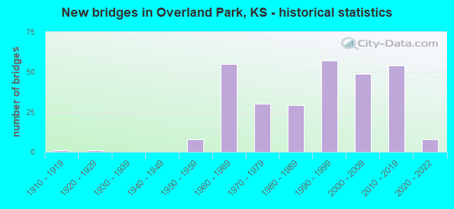
- New bridges - historical statistics
- 11910-1919
- 11920-1929
- 81950-1959
- 551960-1969
- 301970-1979
- 291980-1989
- 571990-1999
- 492000-2009
- 542010-2019
- 82020-2022
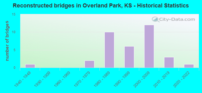
- Reconstructed bridges - Historical Statistics
- 11940-1949
- 01950-1959
- 01960-1969
- 21970-1979
- 101980-1989
- 61990-1999
- 122000-2009
- 32010-2019
- 12020-2022
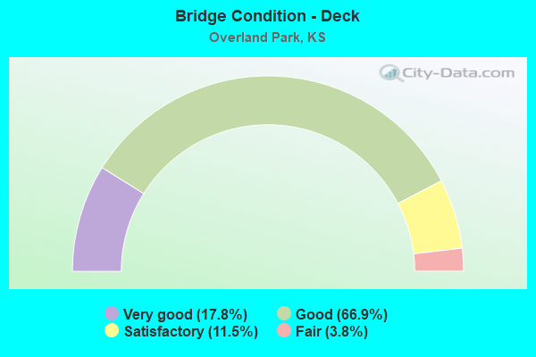
- Bridge Condition - Deck
- 17.8%Very good
- 66.9%Good
- 11.5%Satisfactory
- 3.8%Fair
- Bridge Condition - Superstructure
- 47.1%Very good
- 38.9%Good
- 12.7%Satisfactory
- 1.3%Fair
- 0.6%Poor
- Bridge Condition - Substructure
- 45.2%Very good
- 40.8%Good
- 12.1%Satisfactory
- 1.3%Fair
- 0.6%Poor
- Bridge Condition - Channel
- 33.2%Very good
- 46.2%Good
- 18.5%Satisfactory
- 2.2%Fair

- Bridge Condition - Culverts
- 19.4%Very good
- 63.4%Good
- 14.0%Satisfactory
- 2.2%Fair
- 1.1%Poor
Find on map >> Show street view
Structure Number: 999963500462601, Location: JCT WL I35 I635 SB (Lat: 39.040833, Lng: -94.674444), Route carried "on" structure: Interstate 635, Year Built: 1990, Status: Open, Structure Length: 8.49m (27.85ft), Average Daily Traffic: 34,228 (year 2020), Truck Traffic: 10%, Average Future Daily Traffic: 41,765 (year 2041), Design Load: HS 20, Features Intersected: I35 HWY SB, BNSF RR
Minimum Vertical Clearance: 30.47m (99.97ft), Kilometerpoint: 0.185, Lanes on structure: 2, Lanes under structure: 4, Base Highway Network: Yes (Inventory Route: 4610635, Subroute: 1), Owner: State Highway Agency, Approaching Roadway Width: 14.6m (47.9ft), Skew: 1 degrees, Material/Design: Steel continuous, Design/Construction: Box Beam or Girders - Multiple, Number Of Spans In Main Unit: 4, Length of Maximum Span: 33.5m (109.9ft), Curb-To-Curb Width: 14.6m (47.9ft), Out-to-Out Width: 15.4m (50.5ft)
Condition: Deck: Good, Superstructure: Good, Substructure: Good, Operating Rating: 82.6 metric tons, Method Used To Determine Operating Rating: Load Factor (LF), Inventory Rating: 49.9 metric tons, Method Used To Determine Inventory Rating: Load Factor (LF), Structural Evaluation: Better than present minimum criteria, Deck Geometry: Superior to present desirable criteria, Underclear: Somewhat better than minimum adequacy, Approach Roadway Alignment: Equal to present desirable criteria, Length Of Structure Improvement: 27.85m (91.37ft), Designated Inspection Frequency: Every 24 months, Inspection Date: May 2020, Wearing Surface/Protective System: Wearing Surface: Low Slump Concrete, Deck Protection: Epoxy Coated Reinforcing
Find on map >> Show street view
Structure Number: 999903500462611, Location: 0.14 MI N JCT I35/I635 (Lat: 39.040556, Lng: -94.675000), Route carried "under" structure: Interstate 35, Year Built: 1988, Structure Length: 0. m, Average Daily Traffic: 52,838 (year 2020), Truck Traffic: 11%, Features Intersected: SB I35, BNSF RAILROAD
Minimum Vertical Clearance: 5.51m (18.08ft), Kilometerpoint: 46.549, Lanes on structure: 2, Lanes under structure: 3, Material/Design: Steel continuous, Design/Construction: Box Beam or Girders - Multiple, Length of Maximum Span: 42.1m (138.1ft)
Find on map >> Show street view
Structure Number: 999906900460461, Location: JCT US69ALT/I435, SB (Lat: 38.935000, Lng: -94.705000), Route carried "under" structure: State highway 63060, Year Built: 1965, Structure Length: 0. m, Average Daily Traffic: 64,060 (year 2020), Truck Traffic: 5%, Features Intersected: I435 HWY, Facility Carried by Structure: 69 SB (SWTZ RD
Minimum Vertical Clearance: 5.15m (16.90ft), Kilometerpoint: 8.560, Lanes on structure: 3, Lanes under structure: 10, Material/Design: Concrete continuous, Design/Construction: Box Beam or Girders - Multiple, Length of Maximum Span: 23.2m (76.1ft)
Find on map >> Show street view
Structure Number: 999906900460951, Location: 4.02 MI N MIAMI COLN (Lat: 38.796111, Lng: -94.676111), Route carried "under" structure: US 69, Year Built: 1967, Structure Length: 0. m, Average Daily Traffic: 12,427 (year 2020), Truck Traffic: 9%, Features Intersected: US69 HWY, NB-SB, Facility Carried by Structure: 183RD ST
Minimum Vertical Clearance: 4.87m (15.98ft), Kilometerpoint: 6.466, Lanes on structure: 2, Lanes under structure: 4, Material/Design: Concrete continuous, Design/Construction: Box Beam or Girders - Multiple, Length of Maximum Span: 20.7m (67.9ft)
Find on map >> Show street view
Structure Number: 999906900461141, Location: 3.08 MI S I435 (Lat: 38.900278, Lng: -94.676944), Route carried "under" structure: US 69, Year Built: 1966, Structure Length: 0. m, Average Daily Traffic: 33,639 (year 2020), Truck Traffic: 6%, Features Intersected: NB US 69 HWY, Facility Carried by Structure: SB Bl Valley Pkwy
Minimum Vertical Clearance: 4.91m (16.11ft), Kilometerpoint: 18.062, Lanes on structure: 2, Lanes under structure: 2, Material/Design: Concrete continuous, Design/Construction: Box Beam or Girders - Multiple, Length of Maximum Span: 29.0m (95.1ft)
Find on map >> Show street view
Structure Number: 999906900461221, Location: 2.46 MI S I435 (Lat: 38.905278, Lng: -94.686389), Route carried "under" structure: US 69, Year Built: 1973, Structure Length: 0. m, Average Daily Traffic: 33,639 (year 2020), Truck Traffic: 6%, Features Intersected: US 69 HWY, Facility Carried by Structure: RD SB ANTIOCH
Minimum Vertical Clearance: 5.01m (16.44ft), Kilometerpoint: 19.066, Lanes on structure: 2, Lanes under structure: 4, Material/Design: Steel continuous, Design/Construction: Stringer/Multi-beam, Length of Maximum Span: 25.6m (84.0ft)
Find on map >> Show street view
Structure Number: 999906900461331, Location: 1.54 MI N I435 (Lat: 38.956389, Lng: -94.707778), Route carried "under" structure: US 69, Year Built: 1973, Structure Length: 0. m, Average Daily Traffic: 47,630 (year 2020), Truck Traffic: 3%, Features Intersected: US 69 HWY, Facility Carried by Structure: URB2824,95TH ST
Minimum Vertical Clearance: 5.28m (17.32ft), Kilometerpoint: 25.442, Lanes on structure: 5, Lanes under structure: 8, Material/Design: Steel continuous, Design/Construction: Stringer/Multi-beam, Length of Maximum Span: 29.0m (95.1ft)
Find on map >> Show street view
Structure Number: 999906900461341, Location: 2.11 MI N I435 (Lat: 38.963611, Lng: -94.713611), Route carried "under" structure: US 69, Year Built: 1973, Structure Length: 0. m, Average Daily Traffic: 47,630 (year 2020), Truck Traffic: 3%, Features Intersected: US69 HWY, Facility Carried by Structure: LOCAL RD (91ST ST
Minimum Vertical Clearance: 4.83m (15.85ft), Kilometerpoint: 26.406, Lanes on structure: 3, Lanes under structure: 4, Material/Design: Steel continuous, Design/Construction: Stringer/Multi-beam, Length of Maximum Span: 29.6m (97.1ft)
Find on map >> Show street view
Structure Number: 999906900461371, Location: JCT US69/I435 (Lat: 38.935000, Lng: -94.704722), Route carried "under" structure: State highway 63060, Year Built: 1965, Structure Length: 0. m, Average Daily Traffic: 70,607 (year 2020), Truck Traffic: 6%, Features Intersected: I435 HWY, Facility Carried by Structure: 69 NB (SWTZ RD
Minimum Vertical Clearance: 4.99m (16.37ft), Kilometerpoint: 8.531, Lanes on structure: 3, Lanes under structure: 11, Material/Design: Concrete continuous, Design/Construction: Box Beam or Girders - Multiple, Length of Maximum Span: 23.2m (76.1ft)
Find on map >> Show street view
Structure Number: 999906900462571, Location: JCT EL I35/I635&US69 (Lat: 39.039722, Lng: -94.671111), Route carried "under" structure: Interstate 35, Year Built: 1986, Structure Length: 0. m, Average Daily Traffic: 52,838 (year 2020), Truck Traffic: 11%, Features Intersected: I35 HWY, NB, Facility Carried by Structure: US69 HWY, NB
Minimum Vertical Clearance: 5.04m (16.54ft), Kilometerpoint: 46.801, Lanes on structure: 2, Lanes under structure: 3, Material/Design: Steel continuous, Design/Construction: Box Beam or Girders - Multiple, Length of Maximum Span: 31.1m (102.0ft)
Find on map >> Show street view
Structure Number: 999906900462591, Location: 0.11 MI S OF I35 (Lat: 39.038611, Lng: -94.672222), Route carried "under" structure: Interstate 35, Year Built: 1990, Structure Length: 0. m, Average Daily Traffic: 61,722 (year 2020), Truck Traffic: 11%, Features Intersected: TURKEY CR I35NB, Facility Carried by Structure: US69 HWY SB
Minimum Vertical Clearance: 5.19m (17.03ft), Kilometerpoint: 46.637, Lanes on structure: 2, Lanes under structure: 5, Material/Design: Prestressed concrete continuous, Design/Construction: Stringer/Multi-beam, Length of Maximum Span: 33.5m (109.9ft)
Find on map >> Show street view
Structure Number: 999906900462841, Location: 2.47 MI S I435 (Lat: 38.905278, Lng: -94.686111), Route carried "under" structure: US 69, Year Built: 1989, Structure Length: 0. m, Average Daily Traffic: 33,639 (year 2020), Truck Traffic: 6%, Features Intersected: US69 HWY, Facility Carried by Structure: RD NB, ANTIOCH
Minimum Vertical Clearance: 5.01m (16.44ft), Kilometerpoint: 19.048, Lanes on structure: 2, Lanes under structure: 4, Material/Design: Steel continuous, Design/Construction: Stringer/Multi-beam, Length of Maximum Span: 25.6m (84.0ft)
Find on map >> Show street view
Structure Number: 999906900463371, Location: US-69 & 103RD ST JCT (Lat: 38.941944, Lng: -94.705000), Route carried "under" structure: Ramp State highway 43064, Year Built: 2008, Structure Length: 0. m, Average Daily Traffic: 42,731 (year 2020), Truck Traffic: 5%, Features Intersected: US-69 HWY, Facility Carried by Structure: 103RD ST, EB
Minimum Vertical Clearance: 5.01m (16.44ft), Kilometerpoint: 23.780, Lanes on structure: 2, Lanes under structure: 10, Material/Design: Steel continuous, Design/Construction: Stringer/Multi-beam, Length of Maximum Span: 35.3m (115.8ft)
Find on map >> Show street view
Structure Number: 999906900463381, Location: US-69 & 103RD ST JCT (Lat: 38.941944, Lng: -94.705000), Route carried "under" structure: Ramp State highway 43064, Year Built: 2008, Structure Length: 0. m, Average Daily Traffic: 42,731 (year 2020), Truck Traffic: 5%, Features Intersected: US-69 HWY, Facility Carried by Structure: 103RD ST, WB
Minimum Vertical Clearance: 5.13m (16.83ft), Kilometerpoint: 23.767, Lanes on structure: 3, Lanes under structure: 11, Material/Design: Steel continuous, Design/Construction: Stringer/Multi-beam, Length of Maximum Span: 35.3m (115.8ft)
Find on map >> Show street view
Structure Number: 999906900463681, Location: 3.00 MI S 135TH STREET (Lat: 38.840000, Lng: -94.676389), Route carried "under" structure: US 69, Year Built: 2012, Structure Length: 0. m, Average Daily Traffic: 20,860 (year 2020), Truck Traffic: 6%, Features Intersected: US-69, Facility Carried by Structure: WB 159TH ST
Minimum Vertical Clearance: 5.68m (18.64ft), Kilometerpoint: 11.341, Lanes on structure: 4, Lanes under structure: 4, Material/Design: Prestressed concrete continuous, Design/Construction: Stringer/Multi-beam, Length of Maximum Span: 29.3m (96.1ft)
Find on map >> Show street view
Structure Number: 999906900463691, Location: 3.00 MI S 135TH STREET (Lat: 38.839722, Lng: -94.676389), Route carried "under" structure: US 69, Year Built: 2012, Structure Length: 0. m, Average Daily Traffic: 20,860 (year 2020), Truck Traffic: 6%, Features Intersected: US-69, Facility Carried by Structure: EB 159TH ST
Minimum Vertical Clearance: 5.21m (17.09ft), Kilometerpoint: 11.310, Lanes on structure: 4, Lanes under structure: 4, Material/Design: Prestressed concrete continuous, Design/Construction: Stringer/Multi-beam, Length of Maximum Span: 29.3m (96.1ft)
Find on map >> Show street view
Structure Number: 999906900463961, Location: RAMP WB I-435 TO SB US-69 (Lat: 38.935000, Lng: -94.705556), Route carried "under" structure: State highway 63060, Year Built: 2012, Structure Length: 0. m, Average Daily Traffic: 64,060 (year 2020), Truck Traffic: 5%, Features Intersected: 2 435 RAMPS & E & W 435, Facility Carried by Structure: RAMP 435 W COLLEGE
Minimum Vertical Clearance: 5.49m (18.01ft), Kilometerpoint: 8.602, Lanes on structure: 2, Lanes under structure: 1, Material/Design: Prestressed concrete continuous, Design/Construction: Stringer/Multi-beam, Length of Maximum Span: 27.4m (89.9ft)
Find on map >> Show street view
Structure Number: 999906900463961, Location: RAMP WB I-435 TO SB US-69 (Lat: 38.935000, Lng: -94.705556), Route carried "under" structure: State highway 63060, Year Built: 2012, Structure Length: 0. m, Average Daily Traffic: 64,060 (year 2020), Truck Traffic: 5%, Features Intersected: 2 435 RAMPS & E & W 435, Facility Carried by Structure: RAMP 435 W COLLEGE
Minimum Vertical Clearance: 6.15m (20.18ft), Kilometerpoint: 8.602, Lanes on structure: 2, Lanes under structure: 2, Material/Design: Prestressed concrete continuous, Design/Construction: Stringer/Multi-beam, Length of Maximum Span: 27.4m (89.9ft)
Find on map >> Show street view
Structure Number: 999906900463961, Location: RAMP WB I-435 TO SB US-69 (Lat: 38.935000, Lng: -94.705556), Route carried "under" structure: State highway 63060, Year Built: 2012, Structure Length: 0. m, Average Daily Traffic: 64,060 (year 2020), Truck Traffic: 5%, Features Intersected: 2 435 RAMPS & E & W 435, Facility Carried by Structure: RAMP 435 W COLLEGE
Minimum Vertical Clearance: 5.13m (16.83ft), Kilometerpoint: 8.602, Lanes on structure: 2, Lanes under structure: 7, Material/Design: Prestressed concrete continuous, Design/Construction: Stringer/Multi-beam, Length of Maximum Span: 27.4m (89.9ft)
Find on map >> Show street view
Structure Number: 999906900610151, Location: JOHNSON MIAMI CO LN (Lat: 38.738056, Lng: -94.676111), Route carried "under" structure: US 69, Year Built: 1967, Structure Length: 0. m, Average Daily Traffic: 9,743 (year 2020), Truck Traffic: 11%, Features Intersected: US 69 HWY, Facility Carried by Structure: CO. LN RD 215TH ST
Minimum Vertical Clearance: 4.95m (16.24ft), Kilometerpoint: 39.268, Lanes on structure: 2, Lanes under structure: 4, Material/Design: Concrete continuous, Design/Construction: Box Beam or Girders - Multiple, Length of Maximum Span: 20.7m (67.9ft)
Find on map >> Show street view
Structure Number: 999943500463021, Location: 0.52 MI E US-69 (Lat: 38.930556, Lng: -94.658056), Route carried "under" structure: Interstate 435, Year Built: 1996, Structure Length: 0. m, Average Daily Traffic: 70,139 (year 2020), Truck Traffic: 5%, Features Intersected: I-435 HWY, Facility Carried by Structure: LAMAR AVE
Minimum Vertical Clearance: 5.17m (16.96ft), Kilometerpoint: 4.450, Lanes on structure: 2, Lanes under structure: 10, Material/Design: Steel continuous, Design/Construction: Stringer/Multi-beam, Length of Maximum Span: 25.9m (85.0ft)
Find on map >> Show street view
Structure Number: 999943500463031, Location: 1.02 MI E OF US-169 (Lat: 38.931389, Lng: -94.648611), Route carried "under" structure: State highway 56057, Year Built: 1996, Structure Length: 0. m, Average Daily Traffic: 70,607 (year 2020), Truck Traffic: 6%, Features Intersected: I-435 HWY & NB & SB CD'S, Facility Carried by Structure: NALL NB
Minimum Vertical Clearance: 5.37m (17.62ft), Kilometerpoint: 3.631, Lanes on structure: 4, Lanes under structure: 1, Material/Design: Steel continuous, Design/Construction: Stringer/Multi-beam, Length of Maximum Span: 26.5m (86.9ft)
Find on map >> Show street view
Structure Number: 999943500463031, Location: 1.02 MI E OF US-169 (Lat: 38.931389, Lng: -94.648611), Route carried "under" structure: State highway 56057, Year Built: 1996, Structure Length: 0. m, Average Daily Traffic: 70,607 (year 2020), Truck Traffic: 6%, Features Intersected: I-435 HWY & NB & SB CD'S, Facility Carried by Structure: NALL NB
Minimum Vertical Clearance: 4.99m (16.37ft), Kilometerpoint: 3.631, Lanes on structure: 4, Lanes under structure: 1, Material/Design: Steel continuous, Design/Construction: Stringer/Multi-beam, Length of Maximum Span: 26.5m (86.9ft)
Find on map >> Show street view
Structure Number: 999943500463031, Location: 1.02 MI E OF US-169 (Lat: 38.931389, Lng: -94.648611), Route carried "under" structure: State highway 56057, Year Built: 1996, Structure Length: 0. m, Average Daily Traffic: 70,607 (year 2020), Truck Traffic: 6%, Features Intersected: I-435 HWY & NB & SB CD'S, Facility Carried by Structure: NALL NB
Minimum Vertical Clearance: 4.95m (16.24ft), Kilometerpoint: 3.631, Lanes on structure: 4, Lanes under structure: 8, Material/Design: Steel continuous, Design/Construction: Stringer/Multi-beam, Length of Maximum Span: 26.5m (86.9ft)
Find on map >> Show street view
Structure Number: 999943500463041, Location: 1.02 MI E OF US-169 (Lat: 38.931667, Lng: -94.648889), Route carried "under" structure: State highway 56057, Year Built: 1996, Structure Length: 0. m, Average Daily Traffic: 70,139 (year 2020), Truck Traffic: 6%, Features Intersected: I-435 HWY & NB & SB CD'S, Facility Carried by Structure: NALL SB
Minimum Vertical Clearance: 4.95m (16.24ft), Kilometerpoint: 3.645, Lanes on structure: 4, Lanes under structure: 8, Material/Design: Steel continuous, Design/Construction: Stringer/Multi-beam, Length of Maximum Span: 26.5m (86.9ft)
Find on map >> Show street view
Structure Number: 999943500463041, Location: 1.02 MI E OF US-169 (Lat: 38.931667, Lng: -94.648889), Route carried "under" structure: State highway 56057, Year Built: 1996, Structure Length: 0. m, Average Daily Traffic: 70,139 (year 2020), Truck Traffic: 6%, Features Intersected: I-435 HWY & NB & SB CD'S, Facility Carried by Structure: NALL SB
Minimum Vertical Clearance: 5.37m (17.62ft), Kilometerpoint: 3.645, Lanes on structure: 4, Lanes under structure: 1, Material/Design: Steel continuous, Design/Construction: Stringer/Multi-beam, Length of Maximum Span: 26.5m (86.9ft)
Find on map >> Show street view
Structure Number: 999943500463041, Location: 1.02 MI E OF US-169 (Lat: 38.931667, Lng: -94.648889), Route carried "under" structure: State highway 56057, Year Built: 1996, Structure Length: 0. m, Average Daily Traffic: 70,139 (year 2020), Truck Traffic: 6%, Features Intersected: I-435 HWY & NB & SB CD'S, Facility Carried by Structure: NALL SB
Minimum Vertical Clearance: 4.99m (16.37ft), Kilometerpoint: 3.645, Lanes on structure: 4, Lanes under structure: 1, Material/Design: Steel continuous, Design/Construction: Stringer/Multi-beam, Length of Maximum Span: 26.5m (86.9ft)
Find on map >> Show street view
Structure Number: 999943500463341, Location: I-435 & ANTIOCH RD JCT (Lat: 38.934167, Lng: -94.686111), Route carried "under" structure: Interstate 435, Year Built: 2008, Structure Length: 0. m, Average Daily Traffic: 69,204 (year 2020), Truck Traffic: 5%, Features Intersected: I-435 HWY, Facility Carried by Structure: ANTIOCH ROAD, NB
Minimum Vertical Clearance: 5.25m (17.22ft), Kilometerpoint: 6.915, Lanes on structure: 4, Lanes under structure: 11, Material/Design: Steel continuous, Design/Construction: Stringer/Multi-beam, Length of Maximum Span: 31.0m (101.7ft)
Find on map >> Show street view
Structure Number: 999943500463351, Location: I-435 & ANTIOCH RD JCT (Lat: 38.934167, Lng: -94.686389), Route carried "under" structure: Interstate 435, Year Built: 2008, Structure Length: 0. m, Average Daily Traffic: 70,607 (year 2020), Truck Traffic: 5%, Features Intersected: I-435 HWY, Facility Carried by Structure: ANTIOCH ROAD, SB
Minimum Vertical Clearance: 5.25m (17.22ft), Kilometerpoint: 6.935, Lanes on structure: 5, Lanes under structure: 11, Material/Design: Steel continuous, Design/Construction: Stringer/Multi-beam, Length of Maximum Span: 31.0m (101.7ft)
Find on map >> Show street view
Structure Number: 999943500463411, Location: RAMP US-69S TO I-435 EB (Lat: 38.935278, Lng: -94.703889), Route carried "under" structure: State highway 63060, Year Built: 2009, Structure Length: 0. m, Average Daily Traffic: 70,607 (year 2020), Truck Traffic: 6%, Features Intersected: I-435 HWY & US-69 HWY, Facility Carried by Structure: RAMP 69S TO 435 E
Minimum Vertical Clearance: 6.06m (19.88ft), Kilometerpoint: 23.086, Lanes on structure: 2, Lanes under structure: 3, Material/Design: Steel continuous, Design/Construction: Stringer/Multi-beam, Length of Maximum Span: 73.2m (240.2ft)
Find on map >> Show street view
Structure Number: 999943500463411, Location: RAMP US-69S TO I-435 EB (Lat: 38.935278, Lng: -94.703889), Route carried "under" structure: State highway 63060, Year Built: 2009, Structure Length: 0. m, Average Daily Traffic: 70,607 (year 2020), Truck Traffic: 6%, Features Intersected: I-435 HWY & US-69 HWY, Facility Carried by Structure: RAMP 69S TO 435 E
Minimum Vertical Clearance: 6.75m (22.15ft), Kilometerpoint: 23.086, Lanes on structure: 2, Lanes under structure: 6, Material/Design: Steel continuous, Design/Construction: Stringer/Multi-beam, Length of Maximum Span: 73.2m (240.2ft)
Find on map >> Show street view
Structure Number: 999943500464051, Location: 1.38 MI E I-35 (Lat: 38.935278, Lng: -94.723611), Route carried "under" structure: State highway 59, Year Built: 2014, Structure Length: 0. m, Average Daily Traffic: 59,384 (year 2020), Truck Traffic: 6%, Features Intersected: I435 & RAMP, Facility Carried by Structure: QUIVIRA ROAD SB
Minimum Vertical Clearance: 4.99m (16.37ft), Kilometerpoint: 10.179, Lanes on structure: 5, Lanes under structure: 2, Material/Design: Steel continuous, Design/Construction: Stringer/Multi-beam, Length of Maximum Span: 34.4m (112.9ft)
Find on map >> Show street view
Structure Number: 999943500464051, Location: 1.38 MI E I-35 (Lat: 38.935278, Lng: -94.723611), Route carried "under" structure: State highway 59, Year Built: 2014, Structure Length: 0. m, Average Daily Traffic: 59,384 (year 2020), Truck Traffic: 6%, Features Intersected: I435 & RAMP, Facility Carried by Structure: QUIVIRA ROAD SB
Minimum Vertical Clearance: 4.99m (16.37ft), Kilometerpoint: 10.179, Lanes on structure: 5, Lanes under structure: 8, Material/Design: Steel continuous, Design/Construction: Stringer/Multi-beam, Length of Maximum Span: 34.4m (112.9ft)
Find on map >> Show street view
Structure Number: 999943500464061, Location: 1.38 MI E I-35 (Lat: 38.935000, Lng: -94.723333), Route carried "under" structure: State highway 59, Year Built: 2012, Structure Length: 0. m, Average Daily Traffic: 64,060 (year 2020), Truck Traffic: 5%, Features Intersected: I435 AND RAMP, Facility Carried by Structure: QUIVIRA ROAD NB
Minimum Vertical Clearance: 4.99m (16.37ft), Kilometerpoint: 10.155, Lanes on structure: 5, Lanes under structure: 2, Material/Design: Steel continuous, Design/Construction: Stringer/Multi-beam, Length of Maximum Span: 34.4m (112.9ft)
Find on map >> Show street view
Structure Number: 999943500464061, Location: 1.38 MI E I-35 (Lat: 38.935000, Lng: -94.723333), Route carried "under" structure: State highway 59, Year Built: 2012, Structure Length: 0. m, Average Daily Traffic: 64,060 (year 2020), Truck Traffic: 5%, Features Intersected: I435 AND RAMP, Facility Carried by Structure: QUIVIRA ROAD NB
Minimum Vertical Clearance: 4.99m (16.37ft), Kilometerpoint: 10.155, Lanes on structure: 5, Lanes under structure: 8, Material/Design: Steel continuous, Design/Construction: Stringer/Multi-beam, Length of Maximum Span: 34.4m (112.9ft)
Find on map >> Show street view
Structure Number: 999943500464151, Location: 1.75 MI W OF STATE LINE (Lat: 38.932500, Lng: -94.639444), Route carried "under" structure: State highway 56057, Year Built: 2014, Structure Length: 0. m, Average Daily Traffic: 70,607 (year 2020), Truck Traffic: 6%, Features Intersected: I 435 HWY & NB & SB CD'S, Facility Carried by Structure: ROE AVE SB
Minimum Vertical Clearance: 6.08m (19.95ft), Kilometerpoint: 2.836, Lanes on structure: 3, Lanes under structure: 8, Material/Design: Steel continuous, Design/Construction: Stringer/Multi-beam, Length of Maximum Span: 26.8m (87.9ft)
Find on map >> Show street view
Structure Number: 999943500464151, Location: 1.75 MI W OF STATE LINE (Lat: 38.932500, Lng: -94.639444), Route carried "under" structure: State highway 56057, Year Built: 2014, Structure Length: 0. m, Average Daily Traffic: 70,607 (year 2020), Truck Traffic: 6%, Features Intersected: I 435 HWY & NB & SB CD'S, Facility Carried by Structure: ROE AVE SB
Minimum Vertical Clearance: 7.94m (26.05ft), Kilometerpoint: 2.836, Lanes on structure: 3, Lanes under structure: 1, Material/Design: Steel continuous, Design/Construction: Stringer/Multi-beam, Length of Maximum Span: 26.8m (87.9ft)
Find on map >> Show street view
Structure Number: 999943500464151, Location: 1.75 MI W OF STATE LINE (Lat: 38.932500, Lng: -94.639444), Route carried "under" structure: State highway 56057, Year Built: 2014, Structure Length: 0. m, Average Daily Traffic: 70,607 (year 2020), Truck Traffic: 6%, Features Intersected: I 435 HWY & NB & SB CD'S, Facility Carried by Structure: ROE AVE SB
Minimum Vertical Clearance: 5.70m (18.70ft), Kilometerpoint: 2.836, Lanes on structure: 3, Lanes under structure: 1, Material/Design: Steel continuous, Design/Construction: Stringer/Multi-beam, Length of Maximum Span: 26.8m (87.9ft)
Find on map >> Show street view
Structure Number: 999943500464181, Location: 1.76 MI W OF STATE LINE (Lat: 38.932500, Lng: -94.639722), Route carried "under" structure: State highway 56057, Year Built: 2014, Structure Length: 0. m, Average Daily Traffic: 67,801 (year 2020), Truck Traffic: 6%, Features Intersected: I-435 HWY & NB & SB CD'S, Facility Carried by Structure: ROE AVE NB
Minimum Vertical Clearance: 5.29m (17.36ft), Kilometerpoint: 2.808, Lanes on structure: 3, Lanes under structure: 8, Material/Design: Steel continuous, Design/Construction: Stringer/Multi-beam, Length of Maximum Span: 26.8m (87.9ft)
Find on map >> Show street view
Structure Number: 999943500464181, Location: 1.76 MI W OF STATE LINE (Lat: 38.932500, Lng: -94.639722), Route carried "under" structure: State highway 56057, Year Built: 2014, Structure Length: 0. m, Average Daily Traffic: 67,801 (year 2020), Truck Traffic: 6%, Features Intersected: I-435 HWY & NB & SB CD'S, Facility Carried by Structure: ROE AVE NB
Minimum Vertical Clearance: 7.10m (23.29ft), Kilometerpoint: 2.808, Lanes on structure: 3, Lanes under structure: 1, Material/Design: Steel continuous, Design/Construction: Stringer/Multi-beam, Length of Maximum Span: 26.8m (87.9ft)
Find on map >> Show street view
Structure Number: 999943500464181, Location: 1.76 MI W OF STATE LINE (Lat: 38.932500, Lng: -94.639722), Route carried "under" structure: State highway 56057, Year Built: 2014, Structure Length: 0. m, Average Daily Traffic: 67,801 (year 2020), Truck Traffic: 6%, Features Intersected: I-435 HWY & NB & SB CD'S, Facility Carried by Structure: ROE AVE NB
Minimum Vertical Clearance: 5.11m (16.77ft), Kilometerpoint: 2.808, Lanes on structure: 3, Lanes under structure: 1, Material/Design: Steel continuous, Design/Construction: Stringer/Multi-beam, Length of Maximum Span: 26.8m (87.9ft)
Find on map >> Show street view
Structure Number: 999963500462581, Location: JCT I35 SB/I635 NB (Lat: 39.041389, Lng: -94.672500), Route carried "under" structure: Interstate 35, Year Built: 1985, Structure Length: 0. m, Average Daily Traffic: 52,838 (year 2020), Truck Traffic: 11%, Features Intersected: I35 SB, BNSF RAILROAD
Minimum Vertical Clearance: 4.79m (15.72ft), Kilometerpoint: 46.774, Lanes on structure: 4, Lanes under structure: 4, Material/Design: Steel continuous, Design/Construction: Box Beam or Girders - Multiple, Length of Maximum Span: 32.9m (107.9ft)
Find on map >> Show street view
Structure Number: 999963500462601, Location: JCT WL I35 I635 SB (Lat: 39.040833, Lng: -94.674444), Route carried "under" structure: Interstate 35, Year Built: 1990, Structure Length: 0. m, Average Daily Traffic: 52,838 (year 2020), Truck Traffic: 11%, Features Intersected: I35 HWY SB, BNSF RR
Minimum Vertical Clearance: 4.90m (16.08ft), Kilometerpoint: 46.613, Lanes on structure: 2, Lanes under structure: 4, Material/Design: Steel continuous, Design/Construction: Box Beam or Girders - Multiple, Length of Maximum Span: 33.5m (109.9ft)