Bridge Statistics for Niagara Falls, New York (NY)
Condition, Traffic, Stress, Structural Evaluation, Project Costs
- National Bridge Inventory (NBI) Statistics
- 114Number of bridges
- 2,165ft / 660mTotal length
- $678,775,000Total costs
- 786,384Total average daily traffic
- 45,940Total average daily truck traffic
- National Bridge Inventory (NBI) Registered Bridges for Niagara Falls
- No street view available for this location
- New bridges - historical statistics
- 2Before 1900
- 31900-1909
- 31910-1919
- 21920-1929
- 31930-1939
- 41940-1949
- 61950-1959
- 451960-1969
- 231970-1979
- 21980-1989
- 81990-1999
- 132010-2019
- Reconstructed bridges - Historical Statistics
- 11950-1959
- 01960-1969
- 01970-1979
- 51980-1989
- 61990-1999
- 42000-2009
- 22010-2019
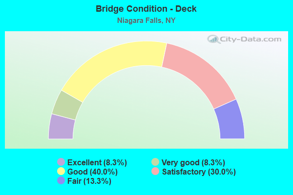
- Bridge Condition - Deck
- 8.3%Excellent
- 8.3%Very good
- 40.0%Good
- 30.0%Satisfactory
- 13.3%Fair
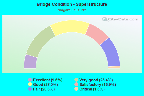
- Bridge Condition - Superstructure
- 9.5%Excellent
- 25.4%Very good
- 27.0%Good
- 15.9%Satisfactory
- 20.6%Fair
- 1.6%Critical
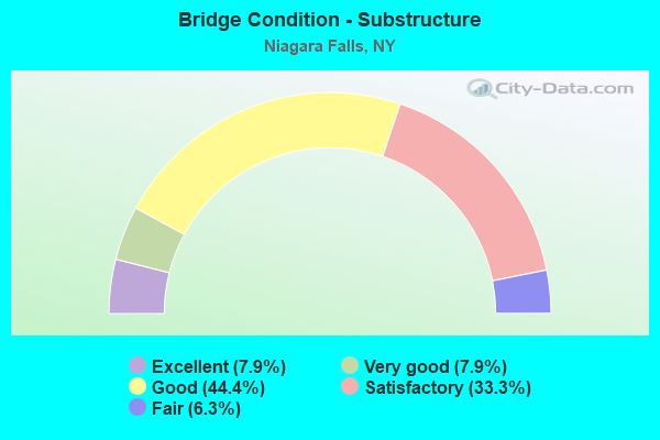
- Bridge Condition - Substructure
- 7.9%Excellent
- 7.9%Very good
- 44.4%Good
- 33.3%Satisfactory
- 6.3%Fair

- Bridge Condition - Channel
- 20.8%Very good
- 54.2%Good
- 25.0%Satisfactory
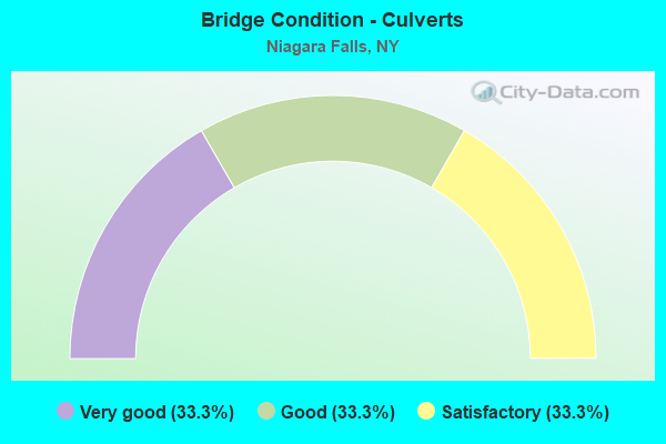
- Bridge Condition - Culverts
- 33.3%Very good
- 33.3%Good
- 33.3%Satisfactory
Find on map >> Show street view
Structure Number: 1068261, Location: 0.5 MI S 957A ACCESS 190I (Lat: 43.141681, Lng: -79.039514), Route carried "on" structure: State highway 957A, Year Built: 1963, Year Reconstructed: 1992, Status: Closed, Structure Length: 58.95m (193.41ft), Average Daily Traffic: 886 (year 2018), Truck Traffic: 1%, Average Future Daily Traffic: 1,026 (year 2040), Design Load: H 20, Features Intersected: RBT MOSES PWRPLNT
Minimum Vertical Clearance: 30+ m (98+ ft), Kilometerpoint: 12.969, Lanes on structure: 2, Base Highway Network: Yes, Owner: State Agenciy, Maintenance Responsibility: State Highway Agency, Approaching Roadway Width: 8.2m (26.9ft), Material/Design: Prestressed concrete continuous, Design/Construction: Stringer/Multi-beam, Number Of Spans In Main Unit: 39, Length of Maximum Span: 22.9m (75.1ft), Curb or Sidewalk Widths: Left: 0.6m (2.0ft), Right: 1.1m (3.6ft), Curb-To-Curb Width: 8.2m (26.9ft), Out-to-Out Width: 9.9m (32.5ft)
Condition: Deck: Satisfactory, Superstructure: Fair, Substructure: Satisfactory, Approach Roadway Alignment: Equal to present minimum criteria, Bridge Posting: Required (Relationship of Operating Rating to Maximum Legal Load: > 39.9% below), Length Of Structure Improvement: 58.94m (193.37ft), Designated Inspection Frequency: Every 24 months, Inspection Date: January 2021, Bridge Improvement Cost: $18,961,000, Roadway Improvement Cost: $11,103,000, Total Project Cost: $30,064,000 ( Estimate for 2021), Deck Structure Type: Concrete Cast-file-Place, Wearing Surface/Protective System: Wearing Surface: Integral Concrete
Find on map >> Show street view
Structure Number: 1068262, Location: 0.5 MI S 957A ACCESS 190I (Lat: 43.141397, Lng: -79.039417), Route carried "on" structure: State highway 957A, Year Built: 1963, Year Reconstructed: 1992, Status: Open, Structure Length: 58.95m (193.41ft), Average Daily Traffic: 886 (year 2018), Truck Traffic: 1%, Average Future Daily Traffic: 1,026 (year 2040), Design Load: H 20, Features Intersected: RBT MOSES PWRPLNT
Minimum Vertical Clearance: 30+ m (98+ ft), Kilometerpoint: 12.840, Lanes on structure: 2, Base Highway Network: Yes, Owner: State Agenciy, Maintenance Responsibility: State Highway Agency, Approaching Roadway Width: 8.2m (26.9ft), Material/Design: Prestressed concrete continuous, Design/Construction: Stringer/Multi-beam, Number Of Spans In Main Unit: 39, Length of Maximum Span: 22.9m (75.1ft), Curb or Sidewalk Widths: Left: 1.0m (3.3ft), Right: 1.1m (3.6ft), Curb-To-Curb Width: 8.2m (26.9ft), Out-to-Out Width: 10.3m (33.8ft)
Condition: Deck: Satisfactory, Superstructure: Fair, Substructure: Satisfactory, Operating Rating: 38.1 metric tons, Method Used To Determine Operating Rating: Load Factor (LF), Inventory Rating: 20.9 metric tons, Method Used To Determine Inventory Rating: Load Factor (LF), Structural Evaluation: Somewhat better than minimum adequacy, Deck Geometry: Somewhat better than minimum adequacy, Approach Roadway Alignment: Equal to present minimum criteria, Length Of Structure Improvement: 58.94m (193.37ft), Designated Inspection Frequency: Every 24 months, Inspection Date: January 2021, Bridge Improvement Cost: $20,025,000, Roadway Improvement Cost: $11,726,000, Total Project Cost: $31,751,000 ( Estimate for 2021), Deck Structure Type: Concrete Cast-file-Place, Wearing Surface/Protective System: Wearing Surface: Integral Concrete
Find on map >> Show street view
Structure Number: 1074561, Location: 0.2 MI E JCT 951A & 190I (Lat: 43.080514, Lng: -78.987092), Route carried "on" structure: State highway 951A, Year Built: 1991, Status: Open, Structure Length: 4.36m (14.30ft), Average Daily Traffic: 1,649 (year 2019), Truck Traffic: 1%, Average Future Daily Traffic: 1,910 (year 2040), Design Load: HS 20, Features Intersected: RMSP RAMP W W.BND
Minimum Vertical Clearance: 30+ m (98+ ft), Kilometerpoint: 0.563, Lanes on structure: 2, Lanes under structure: 2, Base Highway Network: Yes, Owner: State Highway Agency, Approaching Roadway Width: 12.5m (41.0ft), Skew: 3 degrees, Material/Design: Steel, Design/Construction: Stringer/Multi-beam, Number Of Spans In Main Unit: 1, Length of Maximum Span: 42.6m (139.8ft), Curb-To-Curb Width: 12.2m (40.0ft), Out-to-Out Width: 13.0m (42.7ft)
Condition: Deck: Very good, Superstructure: Very good, Substructure: Good, Operating Rating: 76.2 metric tons, Method Used To Determine Operating Rating: Load Factor (LF), Inventory Rating: 33.6 metric tons, Method Used To Determine Inventory Rating: Load Factor (LF), Structural Evaluation: Better than present minimum criteria, Deck Geometry: Better than present minimum criteria, Underclear: High priority of corrective action, Approach Roadway Alignment: Equal to present desirable criteria, Length Of Structure Improvement: 4.35m (14.27ft), Designated Inspection Frequency: Every 24 months, Inspection Date: March 2020, Bridge Improvement Cost: $2,834,000, Roadway Improvement Cost: $1,660,000, Total Project Cost: $4,494,000 ( Estimate for 2021), Deck Structure Type: Concrete Cast-file-Place, Wearing Surface/Protective System: Wearing Surface: Integral Concrete, Deck Protection: Epoxy Coated Reinforcing
Find on map >> Show street view
Structure Number: 1074562, Location: 0.2 MI E JCT 951A & 190I (Lat: 43.080392, Lng: -78.987311), Route carried "on" structure: State highway 951A, Year Built: 1991, Status: Open, Structure Length: 4.36m (14.30ft), Average Daily Traffic: 1,649 (year 2019), Truck Traffic: 1%, Average Future Daily Traffic: 1,910 (year 2040), Design Load: HS 20, Features Intersected: RMSP RAMP W W BND
Minimum Vertical Clearance: 30+ m (98+ ft), Kilometerpoint: 0.563, Lanes on structure: 2, Lanes under structure: 2, Base Highway Network: Yes, Owner: State Highway Agency, Approaching Roadway Width: 12.5m (41.0ft), Skew: 3 degrees, Material/Design: Steel, Design/Construction: Stringer/Multi-beam, Number Of Spans In Main Unit: 1, Length of Maximum Span: 42.6m (139.8ft), Curb-To-Curb Width: 12.2m (40.0ft), Out-to-Out Width: 13.0m (42.7ft)
Condition: Deck: Good, Superstructure: Very good, Substructure: Good, Operating Rating: 76.2 metric tons, Method Used To Determine Operating Rating: Load Factor (LF), Inventory Rating: 33.6 metric tons, Method Used To Determine Inventory Rating: Load Factor (LF), Structural Evaluation: Better than present minimum criteria, Deck Geometry: Better than present minimum criteria, Underclear: High priority of corrective action, Approach Roadway Alignment: Equal to present desirable criteria, Length Of Structure Improvement: 4.35m (14.27ft), Designated Inspection Frequency: Every 24 months, Inspection Date: March 2020, Bridge Improvement Cost: $2,846,000, Roadway Improvement Cost: $1,667,000, Total Project Cost: $4,513,000 ( Estimate for 2021), Deck Structure Type: Concrete Cast-file-Place, Wearing Surface/Protective System: Wearing Surface: Integral Concrete, Deck Protection: Epoxy Coated Reinforcing
Find on map >> Show street view
Structure Number: 203955, Location: 0.4 MI E JCT RTS 182 & 61 (Lat: 43.107064, Lng: -79.021175), Route carried "on" structure: City street 182, Year Built: 1995, Status: Open, Structure Length: 1.65m (5.41ft), Average Daily Traffic: 8,365 (year 2019), Truck Traffic: 2%, Average Future Daily Traffic: 8,833 (year 2040), Design Load: HS 25 or greater, Features Intersected: W BR GILL CREEK
Minimum Vertical Clearance: 30+ m (98+ ft), Kilometerpoint: 3.218, Lanes on structure: 2, Base Highway Network: Yes, Owner: City or Municipal Highway Agency, Approaching Roadway Width: 10.7m (35.1ft), Skew: 3 degrees, Material/Design: Prestressed concrete, Design/Construction: Box Beam or Girders - Multiple, Number Of Spans In Main Unit: 1, Length of Maximum Span: 15.2m (49.9ft), Curb-To-Curb Width: 11.0m (36.1ft), Out-to-Out Width: 11.6m (38.1ft)
Condition: Deck: Good, Superstructure: Good, Substructure: Good, Channel: Good, Inventory Rating: 47.2 metric tons, Method Used To Determine Inventory Rating: Load Factor (LF), Structural Evaluation: Better than present minimum criteria, Deck Geometry: Meets minimum limits, Waterway Adequacy: Somewhat better than minimum adequacy, Approach Roadway Alignment: Equal to present desirable criteria, Length Of Structure Improvement: 1.64m (5.38ft), Designated Inspection Frequency: Every 24 months, Inspection Date: May 2021, Bridge Improvement Cost: $817,000, Roadway Improvement Cost: $478,000, Total Project Cost: $1,295,000 ( Estimate for 2021), Deck Structure Type: Concrete Cast-file-Place, Wearing Surface/Protective System: Wearing Surface: Integral Concrete, Deck Protection: Epoxy Coated Reinforcing
Find on map >> Show street view
Structure Number: 203956, Location: 0.5 MI W JCT RTS 182+I190 (Lat: 43.107203, Lng: -79.001858), Route carried "on" structure: City street 182, Year Built: 1962, Status: Open, Structure Length: 5.79m (19.00ft), Average Daily Traffic: 8,365 (year 2019), Truck Traffic: 2%, Average Future Daily Traffic: 8,833 (year 2040), Design Load: HS 20+Mod, Features Intersected: CSXT
Minimum Vertical Clearance: 30+ m (98+ ft), Kilometerpoint: 4.747, Lanes on structure: 4, Base Highway Network: Yes, Owner: City or Municipal Highway Agency, Approaching Roadway Width: 15.8m (51.8ft), Skew: 20 degrees, Material/Design: Steel, Design/Construction: Stringer/Multi-beam, Number Of Spans In Main Unit: 3, Length of Maximum Span: 30.5m (100.1ft), Curb or Sidewalk Widths: Left: 2.0m (6.6ft), Right: 2.0m (6.6ft), Curb-To-Curb Width: 15.8m (51.8ft), Out-to-Out Width: 20.7m (67.9ft)
Condition: Deck: Fair, Superstructure: Fair, Substructure: Satisfactory, Operating Rating: 36.3 metric tons, Method Used To Determine Operating Rating: Load Factor (LF), Inventory Rating: 21.8 metric tons, Method Used To Determine Inventory Rating: Load Factor (LF), Structural Evaluation: Somewhat better than minimum adequacy, Deck Geometry: Meets minimum limits, Underclear: Equal to present minimum criteria, Approach Roadway Alignment: Equal to present minimum criteria, Length Of Structure Improvement: 5.79m (19.00ft), Designated Inspection Frequency: Every 24 months, Inspection Date: December 2020, Bridge Improvement Cost: $4,268,000, Roadway Improvement Cost: $2,499,000, Total Project Cost: $6,767,000 ( Estimate for 2021), Deck Structure Type: Concrete Cast-file-Place, Wearing Surface/Protective System: Wearing Surface: Monolithic Concrete
Find on map >> Show street view
Structure Number: 204387, Location: 0.8 MI S JCT RTS 265 + 62 (Lat: 43.080206, Lng: -78.959806), Route carried "on" structure: State highway 265, Year Built: 1949, Status: Open, Structure Length: 2.87m (9.42ft), Average Daily Traffic: 2,034 (year 2018), Truck Traffic: 3%, Average Future Daily Traffic: 2,043 (year 2040), Features Intersected: CAYUGA CREEK
Minimum Vertical Clearance: 30+ m (98+ ft), Kilometerpoint: 9.992, Lanes on structure: 2, Base Highway Network: Yes, Owner: City or Municipal Highway Agency, Approaching Roadway Width: 9.1m (29.9ft), Skew: 3 degrees, Material/Design: Concrete, Design/Construction: Frame, Number Of Spans In Main Unit: 1, Length of Maximum Span: 27.7m (90.9ft), Curb or Sidewalk Widths: Left: 1.9m (6.2ft), Right: 2.0m (6.6ft), Curb-To-Curb Width: 9.1m (29.9ft), Out-to-Out Width: 14.2m (46.6ft)
Condition: Deck: Fair, Superstructure: Fair, Substructure: Satisfactory, Channel: Satisfactory, Operating Rating: 69.2 metric tons, Method Used To Determine Operating Rating: Field evaluation and documented engineering judgment, Inventory Rating: 25.7 metric tons, Method Used To Determine Inventory Rating: Field evaluation and documented engineering judgment, Structural Evaluation: Somewhat better than minimum adequacy, Deck Geometry: Meets minimum limits, Waterway Adequacy: Superior to present desirable criteria, Approach Roadway Alignment: High priority of replacement, Length Of Structure Improvement: 2.86m (9.38ft), Designated Inspection Frequency: Every 24 months, Inspection Date: September 2020, Bridge Improvement Cost: $2,853,000, Roadway Improvement Cost: $1,671,000, Total Project Cost: $4,524,000 ( Estimate for 2021), Wearing Surface/Protective System: Wearing Surface: Bituminous
Find on map >> Show street view
Structure Number: 204732, Location: 1.5 MI E JCT RTS 384&190I (Lat: 43.078211, Lng: -78.961039), Route carried "on" structure: City street 384, Year Built: 1977, Year Reconstructed: 2018, Status: Open, Structure Length: 3.54m (11.61ft), Average Daily Traffic: 2,796 (year 2019), Truck Traffic: 5%, Average Future Daily Traffic: 2,952 (year 2040), Design Load: HS 20, Features Intersected: CAYUGA CREEK
Minimum Vertical Clearance: 30+ m (98+ ft), Kilometerpoint: 10.040, Lanes on structure: 3, Base Highway Network: Yes, Owner: City or Municipal Highway Agency, Approaching Roadway Width: 11.3m (37.1ft), Skew: 4 degrees, Material/Design: Steel, Design/Construction: Stringer/Multi-beam, Number Of Spans In Main Unit: 1, Length of Maximum Span: 35.0m (114.8ft), Curb or Sidewalk Widths: Left: 1.5m (4.9ft), Right: 0.0m, Curb-To-Curb Width: 11.3m (37.1ft), Out-to-Out Width: 13.7m (44.9ft)
Condition: Deck: Satisfactory, Superstructure: Good, Substructure: Good, Channel: Very good, Operating Rating: 68.4 metric tons, Method Used To Determine Operating Rating: Load and Resistance Factor Rating (LRFR) rating reported by rating factor(RF) method using HL-93 loadings, Inventory Rating: 52.8 metric tons, Method Used To Determine Inventory Rating: Load and Resistance Factor Rating (LRFR) rating reported by rating factor(RF) method using HL-93 loadings, Structural Evaluation: Better than present minimum criteria, Deck Geometry: High priority of replacement, Waterway Adequacy: Superior to present desirable criteria, Approach Roadway Alignment: Better than present minimum criteria, Length Of Structure Improvement: 3.53m (11.58ft), Designated Inspection Frequency: Every 24 months, Inspection Date: October 2020, Bridge Improvement Cost: $2,587,000, Roadway Improvement Cost: $1,515,000, Total Project Cost: $4,102,000 ( Estimate for 2021), Deck Structure Type: Concrete Cast-file-Place, Wearing Surface/Protective System: Wearing Surface: Integral Concrete
Find on map >> Show street view
Structure Number: 204735, Location: 0.4 MI W JCT RTS 384&61 (Lat: 43.082736, Lng: -79.025450), Route carried "on" structure: City street 384, Year Built: 1993, Status: Open, Structure Length: 2.77m (9.09ft), Average Daily Traffic: 3,573 (year 2018), Truck Traffic: 10%, Average Future Daily Traffic: 3,589 (year 2040), Design Load: HS 20+Mod, Features Intersected: GILL CREEK
Minimum Vertical Clearance: 30+ m (98+ ft), Kilometerpoint: 15.591, Lanes on structure: 2, Base Highway Network: Yes, Owner: City or Municipal Highway Agency, Approaching Roadway Width: 8.5m (27.9ft), Material/Design: Prestressed concrete, Design/Construction: Box Beam or Girders - Multiple, Number Of Spans In Main Unit: 1, Length of Maximum Span: 26.2m (86.0ft), Curb or Sidewalk Widths: Left: 1.4m (4.6ft), Right: 0.0m, Curb-To-Curb Width: 11.6m (38.1ft), Out-to-Out Width: 13.9m (45.6ft)
Condition: Deck: Good, Superstructure: Good, Substructure: Very good, Channel: Good, Operating Rating: 94.3 metric tons, Method Used To Determine Operating Rating: Load Factor (LF), Inventory Rating: 50.8 metric tons, Method Used To Determine Inventory Rating: Load Factor (LF), Structural Evaluation: Better than present minimum criteria, Deck Geometry: Somewhat better than minimum adequacy, Waterway Adequacy: Somewhat better than minimum adequacy, Approach Roadway Alignment: Equal to present desirable criteria, Length Of Structure Improvement: 2.77m (9.09ft), Designated Inspection Frequency: Every 24 months, Inspection Date: May 2021, Bridge Improvement Cost: $1,146,000, Roadway Improvement Cost: $671,000, Total Project Cost: $1,818,000 ( Estimate for 2021), Deck Structure Type: Concrete Cast-file-Place, Wearing Surface/Protective System: Wearing Surface: Integral Concrete
Find on map >> Show street view
Structure Number: 20602, Location: JCT US 62A & SH 61 (Lat: 43.095147, Lng: -79.023600), Route carried "on" structure: Alternate State highway 62, Year Built: 1979, Status: Open, Structure Length: 1.01m (3.31ft), Average Daily Traffic: 10,194 (year 2020), Truck Traffic: 3%, Average Future Daily Traffic: 10,764 (year 2040), Design Load: HS 20+Mod, Features Intersected: GILL CREEK
Minimum Vertical Clearance: 30+ m (98+ ft), Kilometerpoint: 2.671, Lanes on structure: 5, Base Highway Network: Yes, Owner: City or Municipal Highway Agency, Approaching Roadway Width: 17.7m (58.1ft), Material/Design: Prestressed concrete, Design/Construction: Box Beam or Girders - Multiple, Number Of Spans In Main Unit: 1, Length of Maximum Span: 9.7m (31.8ft), Curb or Sidewalk Widths: Left: 2.4m (7.9ft), Right: 2.4m (7.9ft), Curb-To-Curb Width: 17.7m (58.1ft), Out-to-Out Width: 23.3m (76.4ft)
Condition: Deck: Satisfactory, Superstructure: Satisfactory, Substructure: Satisfactory, Channel: Good, Operating Rating: 97.1 metric tons, Method Used To Determine Operating Rating: Load Factor (LF), Inventory Rating: 55.3 metric tons, Method Used To Determine Inventory Rating: Load Factor (LF), Structural Evaluation: Equal to present minimum criteria, Deck Geometry: High priority of replacement, Waterway Adequacy: Superior to present desirable criteria, Approach Roadway Alignment: Equal to present desirable criteria, Length Of Structure Improvement: 1.00m (3.28ft), Designated Inspection Frequency: Every 24 months, Inspection Date: September 2020, Bridge Improvement Cost: $1,398,000, Roadway Improvement Cost: $819,000, Total Project Cost: $2,216,000 ( Estimate for 2021), Deck Structure Type: Concrete Cast-file-Place, Wearing Surface/Protective System: Wearing Surface: Bituminous
Find on map >> Show street view
Structure Number: 225755, Location: 1 MI SW JCT RTS 31 & 61 (Lat: 43.110467, Lng: -79.049006), Route carried "on" structure: City street , Year Built: 1980, Status: Open, Structure Length: 4.97m (16.31ft), Average Daily Traffic: 4,818 (year 2018), Truck Traffic: 2%, Average Future Daily Traffic: 5,087 (year 2040), Design Load: HS 20, Features Intersected: CSX TRANS/AMTRAK, Facility Carried by Structure: ELEVENTH STREET
Minimum Vertical Clearance: 30+ m (98+ ft), Kilometerpoint: 1.255, Lanes on structure: 2, Owner: City or Municipal Highway Agency, Approaching Roadway Width: 12.2m (40.0ft), Skew: 1 degrees, Material/Design: Prestressed concrete, Design/Construction: Box Beam or Girders - Multiple, Number Of Spans In Main Unit: 3, Length of Maximum Span: 16.7m (54.8ft), Curb or Sidewalk Widths: Left: 1.8m (5.9ft), Right: 1.8m (5.9ft), Curb-To-Curb Width: 12.2m (40.0ft), Out-to-Out Width: 16.4m (53.8ft)
Condition: Deck: Satisfactory, Superstructure: Satisfactory, Substructure: Satisfactory, Operating Rating: 26.9 metric tons, Method Used To Determine Operating Rating: Load and Resistance Factor Rating (LRFR) rating reported by rating factor(RF) method using HL-93 loadings, Inventory Rating: 6.2 metric tons, Method Used To Determine Inventory Rating: Load and Resistance Factor Rating (LRFR) rating reported by rating factor(RF) method using HL-93 loadings, Structural Evaluation: High priority of corrective action, Deck Geometry: Equal to present minimum criteria, Underclear: Meets minimum limits, Approach Roadway Alignment: Better than present minimum criteria, Length Of Structure Improvement: 4.96m (16.27ft), Designated Inspection Frequency: Every 24 months, Inspection Date: December 2020, Bridge Improvement Cost: $2,632,000, Roadway Improvement Cost: $1,541,000, Total Project Cost: $4,174,000 ( Estimate for 2021), Wearing Surface/Protective System: Wearing Surface: Integral Concrete
Find on map >> Show street view
Structure Number: 226085, Location: NIAGARA FALLS SOUTH (Lat: 43.086964, Lng: -79.022156), Route carried "on" structure: City street , Year Built: 1946, Year Reconstructed: 2005, Status: Open, Structure Length: 2.38m (7.81ft), Average Daily Traffic: 1,597 (year 2020), Truck Traffic: 6%, Average Future Daily Traffic: 1,686 (year 2040), Features Intersected: GILL CREEK, Facility Carried by Structure: PACKARD ROAD
Minimum Vertical Clearance: 30+ m (98+ ft), Kilometerpoint: 0.097, Lanes on structure: 2, Owner: City or Municipal Highway Agency, Approaching Roadway Width: 12.2m (40.0ft), Skew: 4 degrees, Material/Design: Concrete, Design/Construction: Frame, Number Of Spans In Main Unit: 1, Length of Maximum Span: 22.2m (72.8ft), Curb or Sidewalk Widths: Left: 1.9m (6.2ft), Right: 1.9m (6.2ft), Curb-To-Curb Width: 12.2m (40.0ft), Out-to-Out Width: 17.3m (56.8ft)
Condition: Deck: Satisfactory, Superstructure: Satisfactory, Substructure: Good, Channel: Good, Operating Rating: 61.3 metric tons, Method Used To Determine Operating Rating: Field evaluation and documented engineering judgment, Inventory Rating: 23.7 metric tons, Method Used To Determine Inventory Rating: Field evaluation and documented engineering judgment, Structural Evaluation: Equal to present minimum criteria, Deck Geometry: Better than present minimum criteria, Waterway Adequacy: Somewhat better than minimum adequacy, Approach Roadway Alignment: Equal to present minimum criteria, Length Of Structure Improvement: 2.37m (7.78ft), Designated Inspection Frequency: Every 24 months, Inspection Date: May 2021, Bridge Improvement Cost: $2,849,000, Roadway Improvement Cost: $1,668,000, Total Project Cost: $4,517,000 ( Estimate for 2021), Wearing Surface/Protective System: Wearing Surface: Monolithic Concrete
Find on map >> Show street view
Structure Number: 226086, Location: 0.1M W ON NIAGARAST&RTE61 (Lat: 43.088183, Lng: -79.021603), Route carried "on" structure: City street , Year Built: 1990, Status: Open, Structure Length: 2.01m (6.59ft), Average Daily Traffic: 3,086 (year 2019), Truck Traffic: 3%, Average Future Daily Traffic: 3,818 (year 2040), Design Load: HS 20, Features Intersected: GILL CREEK, Facility Carried by Structure: NIAGARA STREET
Minimum Vertical Clearance: 30+ m (98+ ft), Kilometerpoint: 1.786, Lanes on structure: 3, Owner: City or Municipal Highway Agency, Approaching Roadway Width: 13.4m (44.0ft), Material/Design: Prestressed concrete, Design/Construction: Box Beam or Girders - Multiple, Number Of Spans In Main Unit: 1, Length of Maximum Span: 19.5m (64.0ft), Curb or Sidewalk Widths: Left: 1.5m (4.9ft), Right: 1.5m (4.9ft), Curb-To-Curb Width: 13.4m (44.0ft), Out-to-Out Width: 17.1m (56.1ft)
Condition: Deck: Fair, Superstructure: Good, Substructure: Good, Channel: Very good, Operating Rating: 78.0 metric tons, Method Used To Determine Operating Rating: Load Factor (LF), Inventory Rating: 46.3 metric tons, Method Used To Determine Inventory Rating: Load Factor (LF), Structural Evaluation: Better than present minimum criteria, Deck Geometry: Somewhat better than minimum adequacy, Waterway Adequacy: Superior to present desirable criteria, Approach Roadway Alignment: Equal to present desirable criteria, Length Of Structure Improvement: 2.01m (6.59ft), Designated Inspection Frequency: Every 24 months, Inspection Date: September 2020, Bridge Improvement Cost: $797,000, Roadway Improvement Cost: $467,000, Total Project Cost: $1,264,000 ( Estimate for 2021), Deck Structure Type: Concrete Cast-file-Place, Wearing Surface/Protective System: Wearing Surface: Integral Concrete
Find on map >> Show street view
Structure Number: 226087, Location: BTWN SH62A&SH182 OV HY PK (Lat: 43.099772, Lng: -79.022831), Route carried "on" structure: City street , Year Built: 1937, Year Reconstructed: 1990, Status: Open, Structure Length: 4.94m (16.21ft), Average Daily Traffic: 795 (year 2020), Truck Traffic: 3%, Average Future Daily Traffic: 1,113 (year 2040), Design Load: HS 20+Mod, Features Intersected: HYDE PARK LAKE, Facility Carried by Structure: ROBBINS DRIVE
Minimum Vertical Clearance: 30+ m (98+ ft), Kilometerpoint: 0.563, Lanes on structure: 2, Owner: City or Municipal Highway Agency, Approaching Roadway Width: 7.3m (24.0ft), Material/Design: Prestressed concrete continuous, Design/Construction: Box Beam or Girders - Multiple, Number Of Spans In Main Unit: 3, Length of Maximum Span: 21.0m (68.9ft), Curb or Sidewalk Widths: Left: 1.5m (4.9ft), Right: 1.5m (4.9ft), Curb-To-Curb Width: 7.3m (24.0ft), Out-to-Out Width: 11.0m (36.1ft)
Condition: Deck: Fair, Superstructure: Good, Substructure: Good, Channel: Good, Operating Rating: 78.9 metric tons, Method Used To Determine Operating Rating: Load Factor (LF), Inventory Rating: 47.2 metric tons, Method Used To Determine Inventory Rating: Load Factor (LF), Structural Evaluation: Better than present minimum criteria, Deck Geometry: Meets minimum limits, Waterway Adequacy: Superior to present desirable criteria, Approach Roadway Alignment: Meets minimum limits, Length Of Structure Improvement: 4.93m (16.17ft), Designated Inspection Frequency: Every 24 months, Underwater Inspection Frequency: Every 60 months, Inspection Date: September 2020, Underwater Inspection Date: September 2019, Bridge Improvement Cost: $1,676,000, Roadway Improvement Cost: $981,000, Total Project Cost: $2,657,000 ( Estimate for 2021), Deck Structure Type: Concrete Cast-file-Place, Wearing Surface/Protective System: Wearing Surface: Integral Concrete
Find on map >> Show street view
Structure Number: 226088, Location: 1.4 MI E INT N21,I190 (Lat: 43.074756, Lng: -78.964036), Route carried "on" structure: City street , Year Built: 1982, Status: Open, Structure Length: 3.72m (12.20ft), Average Daily Traffic: 2,805 (year 2020), Truck Traffic: 4%, Average Future Daily Traffic: 3,470 (year 2040), Design Load: HS 20+Mod, Features Intersected: LITTLE NIAG RIVER, Facility Carried by Structure: SOUTH 86TH STREET
Minimum Vertical Clearance: 30+ m (98+ ft), Kilometerpoint: 0.193, Lanes on structure: 2, Owner: City or Municipal Highway Agency, Approaching Roadway Width: 9.1m (29.9ft), Navigation Control: Yes ( Vertical Clearance: 2.1m (6.9ft), Horizontal Clearance: 15.2m (49.9ft)), Material/Design: Steel, Design/Construction: Stringer/Multi-beam, Number Of Spans In Main Unit: 1, Length of Maximum Span: 36.5m (119.8ft), Curb or Sidewalk Widths: Left: 1.5m (4.9ft), Right: 1.5m (4.9ft), Curb-To-Curb Width: 9.1m (29.9ft), Out-to-Out Width: 12.8m (42.0ft)
Condition: Deck: Satisfactory, Superstructure: Good, Substructure: Satisfactory, Channel: Good, Operating Rating: 86.2 metric tons, Method Used To Determine Operating Rating: Load Factor (LF), Inventory Rating: 51.7 metric tons, Method Used To Determine Inventory Rating: Load Factor (LF), Structural Evaluation: Equal to present minimum criteria, Deck Geometry: Meets minimum limits, Waterway Adequacy: Equal to present desirable criteria, Approach Roadway Alignment: Equal to present desirable criteria, Length Of Structure Improvement: 3.71m (12.17ft), Designated Inspection Frequency: Every 24 months, Inspection Date: September 2020, Bridge Improvement Cost: $2,084,000, Roadway Improvement Cost: $1,221,000, Total Project Cost: $3,305,000 ( Estimate for 2021), Deck Structure Type: Concrete Cast-file-Place, Wearing Surface/Protective System: Wearing Surface: Integral Concrete, Deck Protection: Epoxy Coated Reinforcing
Find on map >> Show street view
Structure Number: 22609, Location: NIAGARA FALLS EAST (Lat: 43.083744, Lng: -78.961933), Route carried "on" structure: City street , Year Built: 1956, Status: Open, Structure Length: 2.71m (8.89ft), Average Daily Traffic: 1,122 (year 2020), Truck Traffic: 2%, Average Future Daily Traffic: 1,571 (year 2040), Features Intersected: CAYUGA CREEK, Facility Carried by Structure: LINDBERGH AVENUE
Minimum Vertical Clearance: 30+ m (98+ ft), Kilometerpoint: 1.239, Lanes on structure: 2, Owner: City or Municipal Highway Agency, Approaching Roadway Width: 9.1m (29.9ft), Material/Design: Concrete, Design/Construction: Frame, Number Of Spans In Main Unit: 1, Length of Maximum Span: 24.9m (81.7ft), Curb or Sidewalk Widths: Left: 2.0m (6.6ft), Right: 2.0m (6.6ft), Curb-To-Curb Width: 9.1m (29.9ft), Out-to-Out Width: 14.0m (45.9ft)
Condition: Deck: Satisfactory, Superstructure: Satisfactory, Substructure: Good, Channel: Good, Operating Rating: 90.4 metric tons, Method Used To Determine Operating Rating: Field evaluation and documented engineering judgment, Inventory Rating: 32.7 metric tons, Method Used To Determine Inventory Rating: Field evaluation and documented engineering judgment, Structural Evaluation: Equal to present minimum criteria, Deck Geometry: Somewhat better than minimum adequacy, Waterway Adequacy: Equal to present desirable criteria, Approach Roadway Alignment: Equal to present minimum criteria, Length Of Structure Improvement: 2.71m (8.89ft), Designated Inspection Frequency: Every 24 months, Inspection Date: September 2020, Bridge Improvement Cost: $2,269,000, Roadway Improvement Cost: $1,328,000, Total Project Cost: $3,597,000 ( Estimate for 2021), Wearing Surface/Protective System: Wearing Surface: Bituminous
Find on map >> Show street view
Structure Number: 226092, Location: NIAGARA FALLS EAST (Lat: 43.087819, Lng: -78.958064), Route carried "on" structure: City street , Year Built: 1954, Status: Open, Structure Length: 2.47m (8.10ft), Average Daily Traffic: 2,391 (year 2017), Truck Traffic: 2%, Average Future Daily Traffic: 3,347 (year 2037), Features Intersected: BERGHOLTZ CREEK, Facility Carried by Structure: 91ST STREET
Minimum Vertical Clearance: 30+ m (98+ ft), Kilometerpoint: 0.563, Lanes on structure: 2, Owner: City or Municipal Highway Agency, Approaching Roadway Width: 9.1m (29.9ft), Skew: 4 degrees, Material/Design: Concrete, Design/Construction: Frame, Number Of Spans In Main Unit: 1, Length of Maximum Span: 20.7m (67.9ft), Curb or Sidewalk Widths: Left: 1.9m (6.2ft), Right: 1.9m (6.2ft), Curb-To-Curb Width: 9.1m (29.9ft), Out-to-Out Width: 14.1m (46.3ft)
Condition: Deck: Fair, Superstructure: Fair, Substructure: Good, Channel: Satisfactory, Operating Rating: 42.6 metric tons, Method Used To Determine Operating Rating: Load Factor (LF), Inventory Rating: 24.5 metric tons, Method Used To Determine Inventory Rating: Load Factor (LF), Structural Evaluation: Somewhat better than minimum adequacy, Deck Geometry: Meets minimum limits, Waterway Adequacy: Superior to present desirable criteria, Approach Roadway Alignment: Equal to present minimum criteria, Length Of Structure Improvement: 2.46m (8.07ft), Designated Inspection Frequency: Every 24 months, Inspection Date: September 2020, Bridge Improvement Cost: $2,277,000, Roadway Improvement Cost: $1,333,000, Total Project Cost: $3,610,000 ( Estimate for 2021), Deck Structure Type: Concrete Cast-file-Place, Wearing Surface/Protective System: Wearing Surface: Bituminous
Find on map >> Show street view
Structure Number: 226093, Location: NIAGARA FALLS EAST (Lat: 43.090056, Lng: -78.962128), Route carried "on" structure: City street , Year Built: 1978, Status: Open, Structure Length: 2.29m (7.51ft), Average Daily Traffic: 4,040 (year 2020), Truck Traffic: 1%, Average Future Daily Traffic: 4,998 (year 2040), Design Load: HS 20, Features Intersected: CAYUGA CREEK, Facility Carried by Structure: CAYUGA DRIVE
Minimum Vertical Clearance: 30+ m (98+ ft), Kilometerpoint: 1.464, Lanes on structure: 2, Owner: City or Municipal Highway Agency, Approaching Roadway Width: 10.4m (34.1ft), Material/Design: Steel, Design/Construction: Stringer/Multi-beam, Number Of Spans In Main Unit: 1, Length of Maximum Span: 22.2m (72.8ft), Curb or Sidewalk Widths: Left: 0.0m, Right: 1.4m (4.6ft), Curb-To-Curb Width: 10.4m (34.1ft), Out-to-Out Width: 12.8m (42.0ft)
Condition: Deck: Good, Superstructure: Good, Substructure: Good, Channel: Good, Operating Rating: 89.8 metric tons, Method Used To Determine Operating Rating: Load Factor (LF), Inventory Rating: 59.0 metric tons, Method Used To Determine Inventory Rating: Load Factor (LF), Structural Evaluation: Better than present minimum criteria, Deck Geometry: Somewhat better than minimum adequacy, Waterway Adequacy: Superior to present desirable criteria, Approach Roadway Alignment: Equal to present minimum criteria, Length Of Structure Improvement: 2.28m (7.48ft), Designated Inspection Frequency: Every 24 months, Inspection Date: May 2020, Bridge Improvement Cost: $1,494,000, Roadway Improvement Cost: $875,000, Total Project Cost: $2,369,000 ( Estimate for 2021), Deck Structure Type: Concrete Cast-file-Place, Wearing Surface/Protective System: Wearing Surface: Integral Concrete
Find on map >> Show street view
Structure Number: 226383, Location: NIAGARA FALLS SE (Lat: 43.099517, Lng: -79.001433), Route carried "on" structure: County highway , Year Built: 1962, Status: Open, Structure Length: 8.14m (26.71ft), Average Daily Traffic: 7,132 (year 2019), Truck Traffic: 5%, Average Future Daily Traffic: 7,531 (year 2040), Design Load: HS 20, Features Intersected: CSX TRANSPRTATION, Facility Carried by Structure: PACKARD ROAD
Minimum Vertical Clearance: 30+ m (98+ ft), Kilometerpoint: 1.078, Lanes on structure: 4, Owner: City or Municipal Highway Agency, Approaching Roadway Width: 15.8m (51.8ft), Skew: 24 degrees, Material/Design: Steel continuous, Design/Construction: Stringer/Multi-beam, Number Of Spans In Main Unit: 3, Length of Maximum Span: 39.6m (129.9ft), Curb or Sidewalk Widths: Left: 2.0m (6.6ft), Right: 2.0m (6.6ft), Curb-To-Curb Width: 15.8m (51.8ft), Out-to-Out Width: 20.7m (67.9ft)
Condition: Deck: Fair, Superstructure: Good, Substructure: Satisfactory, Operating Rating: 39.2 metric tons, Method Used To Determine Operating Rating: Load and Resistance Factor Rating (LRFR) rating reported by rating factor(RF) method using HL-93 loadings, Inventory Rating: 30.1 metric tons, Method Used To Determine Inventory Rating: Load and Resistance Factor Rating (LRFR) rating reported by rating factor(RF) method using HL-93 loadings, Structural Evaluation: Equal to present minimum criteria, Deck Geometry: Meets minimum limits, Underclear: Better than present minimum criteria, Approach Roadway Alignment: Equal to present desirable criteria, Length Of Structure Improvement: 8.13m (26.67ft), Designated Inspection Frequency: Every 24 months, Inspection Date: November 2020, Bridge Improvement Cost: $6,063,000, Roadway Improvement Cost: $3,550,000, Total Project Cost: $9,613,000 ( Estimate for 2021), Deck Structure Type: Concrete Cast-file-Place, Wearing Surface/Protective System: Wearing Surface: Monolithic Concrete
Find on map >> Show street view
Structure Number: 226384, Location: NIAGARA FALLS NW. (Lat: 43.112322, Lng: -79.036797), Route carried "on" structure: City street , Year Built: 1966, Year Reconstructed: 2009, Status: Open, Structure Length: 20.48m (67.19ft), Average Daily Traffic: 2,762 (year 2020), Truck Traffic: 2%, Average Future Daily Traffic: 2,916 (year 2040), Design Load: HS 25 or greater, Features Intersected: CSX TRANS/AMTRAK, Facility Carried by Structure: LOCKPORT STREET
Minimum Vertical Clearance: 30+ m (98+ ft), Kilometerpoint: 1.496, Lanes on structure: 4, Owner: City or Municipal Highway Agency, Approaching Roadway Width: 16.8m (55.1ft), Skew: 20 degrees, Material/Design: Steel continuous, Design/Construction: Girder and Floorbeam System, Number Of Spans In Main Unit: 6, Length of Maximum Span: 37.1m (121.7ft), Curb or Sidewalk Widths: Left: 1.5m (4.9ft), Right: 1.5m (4.9ft), Curb-To-Curb Width: 16.7m (54.8ft), Out-to-Out Width: 20.7m (67.9ft)
Condition: Deck: Good, Superstructure: Good, Substructure: Good, Operating Rating: 65.3 metric tons, Method Used To Determine Operating Rating: Load Factor (LF), Inventory Rating: 39.0 metric tons, Method Used To Determine Inventory Rating: Load Factor (LF), Structural Evaluation: Better than present minimum criteria, Deck Geometry: Somewhat better than minimum adequacy, Underclear: Meets minimum limits, Approach Roadway Alignment: Equal to present desirable criteria, Length Of Structure Improvement: 20.48m (67.19ft), Designated Inspection Frequency: Every 24 months, Critical Feature Inspection Frequency: Every 24 months, Inspection Date: September 2021, Critical Feature Inspection Date: September 2021, Bridge Improvement Cost: $14,795,000, Roadway Improvement Cost: $8,664,000, Total Project Cost: $23,459,000 ( Estimate for 2021), Deck Structure Type: Concrete Cast-file-Place, Wearing Surface/Protective System: Wearing Surface: Monolithic Concrete, Deck Protection: Galvanized Reinforcing
Find on map >> Show street view
Structure Number: 5039547, Location: JCT RT 182 + NIAGARA R. (Lat: 43.109308, Lng: -79.057661), Route carried "on" structure: Other road 955, Year Built: 1897, Year Reconstructed: 2013, Status: Open, Structure Length: 24.08m (79.00ft), Average Daily Traffic: 1,091 (year 2011), Truck Traffic: 5%, Average Future Daily Traffic: 1,096 (year 2040), Features Intersected: NIAGARA RIVER, VIA/AMTRA
Minimum Vertical Clearance: 4.26m (13.98ft), Kilometerpoint: 0.000, Lanes on structure: 2, Base Highway Network: Yes, Toll: Toll bridge, Owner: Local Toll Authority, Approaching Roadway Width: 7.9m (25.9ft), Material/Design: Steel, Design/Construction: Arch - Deck, Number Of Spans In Main Unit: 1, Number Of Approach Spans: 2, Length of Maximum Span: 167.6m (549.9ft), Curb or Sidewalk Widths: Left: 3.3m (10.8ft), Right: 3.3m (10.8ft), Curb-To-Curb Width: 8.0m (26.2ft), Out-to-Out Width: 9.4m (30.8ft)
Condition: Deck: Satisfactory, Superstructure: Satisfactory, Substructure: Satisfactory, Channel: Satisfactory, Operating Rating: 73.6 metric tons, Method Used To Determine Operating Rating: Field evaluation and documented engineering judgment, Inventory Rating: 24.5 metric tons, Method Used To Determine Inventory Rating: Field evaluation and documented engineering judgment, Structural Evaluation: Equal to present minimum criteria, Deck Geometry: High priority of corrective action, Waterway Adequacy: Superior to present desirable criteria, Approach Roadway Alignment: High priority of corrective action, Length Of Structure Improvement: 24.07m (78.97ft), Designated Inspection Frequency: Every 24 months, Critical Feature Inspection Frequency: Every 24 months, Inspection Date: May 2020, Critical Feature Inspection Date: May 2020, Bridge Improvement Cost: $9,508,000, Roadway Improvement Cost: $5,568,000, Total Project Cost: $15,076,000 ( Estimate for 2021), Deck Structure Type: Concrete Cast-file-Place, Wearing Surface/Protective System: Wearing Surface: Latex Concrete
Find on map >> Show street view
Structure Number: 5039651, Location: JCT RTS 384 + I-190 (Lat: 43.075803, Lng: -78.990922), Route carried "on" structure: Interstate 190, Year Built: 2014, Status: Open, Structure Length: 3.02m (9.91ft), Average Daily Traffic: 24,370 (year 1997), Truck Traffic: 14%, Design Load: HL 93, Features Intersected: RTE 384
Minimum Vertical Clearance: 30+ m (98+ ft), Kilometerpoint: 0.740, Lanes on structure: 2, Lanes under structure: 5, Base Highway Network: Yes, Owner: State Highway Agency, Approaching Roadway Width: 15.8m (51.8ft), Skew: 1 degrees, Material/Design: Steel, Design/Construction: Stringer/Multi-beam, Number Of Spans In Main Unit: 1, Length of Maximum Span: 30.0m (98.4ft), Curb-To-Curb Width: 15.7m (51.5ft), Out-to-Out Width: 16.6m (54.5ft)
Condition: Deck: Excellent, Superstructure: Excellent, Substructure: Excellent, Operating Rating: 56.1 metric tons, Method Used To Determine Operating Rating: Load and Resistance Factor Rating (LRFR) rating reported by rating factor(RF) method using HL-93 loadings, Inventory Rating: 43.1 metric tons, Method Used To Determine Inventory Rating: Load and Resistance Factor Rating (LRFR) rating reported by rating factor(RF) method using HL-93 loadings, Structural Evaluation: Superior to present desirable criteria, Deck Geometry: Superior to present desirable criteria, Underclear: Equal to present minimum criteria, Approach Roadway Alignment: Equal to present minimum criteria, Length Of Structure Improvement: 3.01m (9.88ft), Designated Inspection Frequency: Every 24 months, Inspection Date: November 2020, Bridge Improvement Cost: $2,553,000, Roadway Improvement Cost: $1,495,000, Total Project Cost: $4,047,000 ( Estimate for 2021), Deck Structure Type: Concrete Cast-file-Place, Wearing Surface/Protective System: Wearing Surface: Bituminous, Deck Protection: Epoxy Coated Reinforcing
Find on map >> Show street view
Structure Number: 5039652, Location: JCT RTS 384 + I-190 (Lat: 43.075744, Lng: -78.990628), Route carried "on" structure: Interstate 190, Year Built: 2014, Status: Open, Structure Length: 3.02m (9.91ft), Average Daily Traffic: 14,007 (year 2020), Truck Traffic: 16%, Average Future Daily Traffic: 15,697 (year 2040), Design Load: HL 93, Features Intersected: RTE 384
Minimum Vertical Clearance: 30+ m (98+ ft), Kilometerpoint: 0.756, Lanes on structure: 2, Lanes under structure: 5, Base Highway Network: Yes, Toll: On toll road, Owner: State Highway Agency, Approaching Roadway Width: 15.8m (51.8ft), Skew: 1 degrees, Material/Design: Steel, Design/Construction: Stringer/Multi-beam, Number Of Spans In Main Unit: 1, Length of Maximum Span: 30.0m (98.4ft), Curb-To-Curb Width: 15.7m (51.5ft), Out-to-Out Width: 16.6m (54.5ft)
Condition: Deck: Excellent, Superstructure: Excellent, Substructure: Excellent, Operating Rating: 58.3 metric tons, Method Used To Determine Operating Rating: Load and Resistance Factor Rating (LRFR) rating reported by rating factor(RF) method using HL-93 loadings, Inventory Rating: 45.0 metric tons, Method Used To Determine Inventory Rating: Load and Resistance Factor Rating (LRFR) rating reported by rating factor(RF) method using HL-93 loadings, Structural Evaluation: Superior to present desirable criteria, Deck Geometry: Superior to present desirable criteria, Underclear: Equal to present minimum criteria, Approach Roadway Alignment: Equal to present minimum criteria, Length Of Structure Improvement: 3.01m (9.88ft), Designated Inspection Frequency: Every 24 months, Inspection Date: December 2020, Bridge Improvement Cost: $2,720,000, Roadway Improvement Cost: $1,593,000, Total Project Cost: $4,313,000 ( Estimate for 2021), Deck Structure Type: Concrete Cast-file-Place, Wearing Surface/Protective System: Wearing Surface: Bituminous, Deck Protection: Epoxy Coated Reinforcing
Find on map >> Show street view
Structure Number: 5045751, Location: INT EXIT 21 ON 190I (Lat: 43.063739, Lng: -78.990908), Route carried "on" structure: Interstate 190, Year Built: 1963, Year Reconstructed: 2013, Status: Open, Structure Length: 122.93m (403.31ft), Average Daily Traffic: 28,012 (year 2014), Truck Traffic: 14%, Design Load: HS 20, Features Intersected: NIAGARA RIVER, NY 957A N
Minimum Vertical Clearance: 5.33m (17.49ft), Kilometerpoint: 1482.082, Lanes on structure: 2, Lanes under structure: 5, Base Highway Network: Yes, Toll: Toll bridge, Owner: State Toll Authority, Approaching Roadway Width: 14.6m (47.9ft), Navigation Control: Yes ( Vertical Clearance: 12.2m (40.0ft), Horizontal Clearance: 82.3m (270.0ft)), Material/Design: Steel continuous, Design/Construction: Truss - Deck, Number Of Spans In Main Unit: 11, Number Of Approach Spans: 5, Length of Maximum Span: 152.4m (500.0ft), Curb or Sidewalk Widths: Left: 1.3m (4.3ft), Right: 0.0m, Curb-To-Curb Width: 7.5m (24.6ft), Out-to-Out Width: 8.1m (26.6ft)
Condition: Deck: Excellent, Superstructure: Fair, Substructure: Good, Channel: Very good, Operating Rating: 51.7 metric tons, Method Used To Determine Operating Rating: Load Factor (LF), Inventory Rating: 32.7 metric tons, Method Used To Determine Inventory Rating: Load Factor (LF), Structural Evaluation: Somewhat better than minimum adequacy, Deck Geometry: High priority of replacement, Underclear: High priority of corrective action, Waterway Adequacy: Equal to present desirable criteria, Approach Roadway Alignment: Equal to present minimum criteria, Length Of Structure Improvement: 122.92m (403.28ft), Designated Inspection Frequency: Every 24 months, Critical Feature Inspection Frequency: Every 24 months, Underwater Inspection Frequency: Every 60 months, Inspection Date: November 2021, Critical Feature Inspection Date: November 2021, Underwater Inspection Date: October 2021, Bridge Improvement Cost: $58,965,000, Roadway Improvement Cost: $34,530,000, Total Project Cost: $93,495,000 ( Estimate for 2021), Deck Structure Type: Concrete Cast-file-Place, Wearing Surface/Protective System: Wearing Surface: Epoxy Overlay
Find on map >> Show street view
Structure Number: 504575A, Location: INT EXIT 21 ON 190I (Lat: 43.074319, Lng: -78.990442), Route carried "on" structure: Interstate , Year Built: 1961, Year Reconstructed: 1989, Status: Open, Structure Length: 4.08m (13.39ft), Average Daily Traffic: 4,773 (year 2020), Truck Traffic: 15%, Average Future Daily Traffic: 5,349 (year 2040), Design Load: HS 20, Features Intersected: NY 957A NIAGARA SCENIC P, Facility Carried by Structure: 190IX NB RAMP TO N
Minimum Vertical Clearance: 30+ m (98+ ft), Kilometerpoint: 0.032, Lanes on structure: 2, Lanes under structure: 5, Owner: State Toll Authority, Approaching Roadway Width: 7.6m (24.9ft), Skew: 1 degrees, Material/Design: Steel, Design/Construction: Stringer/Multi-beam, Number Of Spans In Main Unit: 1, Length of Maximum Span: 39.6m (129.9ft), Curb or Sidewalk Widths: Left: 0.0m, Right: 1.7m (5.6ft), Curb-To-Curb Width: 7.6m (24.9ft), Out-to-Out Width: 10.1m (33.1ft)
Condition: Deck: Good, Superstructure: Very good, Substructure: Good, Operating Rating: 42.6 metric tons, Method Used To Determine Operating Rating: Load Factor (LF), Inventory Rating: 22.7 metric tons, Method Used To Determine Inventory Rating: Load Factor (LF), Structural Evaluation: Somewhat better than minimum adequacy, Deck Geometry: High priority of replacement, Underclear: High priority of corrective action, Approach Roadway Alignment: Equal to present minimum criteria, Length Of Structure Improvement: 4.08m (13.39ft), Designated Inspection Frequency: Every 24 months, Inspection Date: October 2021, Bridge Improvement Cost: $2,401,000, Roadway Improvement Cost: $1,406,000, Total Project Cost: $3,807,000 ( Estimate for 2021), Deck Structure Type: Concrete Cast-file-Place, Wearing Surface/Protective System: Wearing Surface: Epoxy Overlay, Deck Protection: Epoxy Coated Reinforcing
Find on map >> Show street view
Structure Number: 506815, Location: 3.8 MI W EXIT 21 OF I190 (Lat: 43.083169, Lng: -79.062703), Route carried "on" structure: Other road , Year Built: 1960, Year Reconstructed: 2002, Status: Open, Structure Length: 21.92m (71.92ft), Average Daily Traffic: 3,230 (year 2019), Truck Traffic: 10%, Average Future Daily Traffic: 4,522 (year 2039), Design Load: HS 25 or greater, Features Intersected: AMERICAN RAPIDS, PARK RD, Facility Carried by Structure: GOAT ISLND ACCESS
Minimum Vertical Clearance: 30+ m (98+ ft), Kilometerpoint: 0.064, Lanes on structure: 2, Lanes under structure: 2, Owner: State Park, Forest, or Reservation Agency, Approaching Roadway Width: 7.9m (25.9ft), Material/Design: Steel continuous, Design/Construction: Stringer/Multi-beam, Number Of Spans In Main Unit: 4, Length of Maximum Span: 137.1m (449.8ft), Curb or Sidewalk Widths: Left: 2.6m (8.5ft), Right: 2.6m (8.5ft), Curb-To-Curb Width: 7.3m (24.0ft), Out-to-Out Width: 13.4m (44.0ft)
Condition: Deck: Good, Superstructure: Good, Substructure: Good, Channel: Good, Operating Rating: 89.8 metric tons, Method Used To Determine Operating Rating: Load Factor (LF), Inventory Rating: 46.3 metric tons, Method Used To Determine Inventory Rating: Load Factor (LF), Structural Evaluation: Better than present minimum criteria, Deck Geometry: High priority of replacement, Underclear: Equal to present minimum criteria, Waterway Adequacy: Superior to present desirable criteria, Approach Roadway Alignment: Equal to present minimum criteria, Length Of Structure Improvement: 21.91m (71.88ft), Designated Inspection Frequency: Every 24 months, Critical Feature Inspection Frequency: Every 24 months, Inspection Date: December 2020, Critical Feature Inspection Date: December 2020, Bridge Improvement Cost: $10,512,000, Roadway Improvement Cost: $6,156,000, Total Project Cost: $16,668,000 ( Estimate for 2021), Deck Structure Type: Concrete Cast-file-Place, Wearing Surface/Protective System: Wearing Surface: Integral Concrete, Deck Protection: Epoxy Coated Reinforcing
Find on map >> Show street view
Structure Number: 5068199, Location: 0.1 MI W OF INT 104 & 384 (Lat: 43.089953, Lng: -79.067342), Route carried "on" structure: State highway 955, Year Built: 1941, Status: Open, Structure Length: 44.01m (144.39ft), Average Daily Traffic: 5,281 (year 2011), Truck Traffic: 5%, Average Future Daily Traffic: 5,305 (year 2040), Design Load: HS 20, Features Intersected: River Road / Niagara Par
Minimum Vertical Clearance: 4.87m (15.98ft), Kilometerpoint: 0.000, Lanes on structure: 4, Lanes under structure: 8, Base Highway Network: Yes, Toll: Toll bridge, Owner: Local Toll Authority, Approaching Roadway Width: 13.4m (44.0ft), Skew: 20 degrees, Navigation Control: Yes ( Vertical Clearance: 21.9m (71.9ft), Horizontal Clearance: 249.3m (817.9ft)), Material/Design: Steel, Design/Construction: Arch - Deck, Number Of Spans In Main Unit: 1, Number Of Approach Spans: 10, Length of Maximum Span: 303.2m (994.8ft), Curb or Sidewalk Widths: Left: 3.5m (11.5ft), Right: 0.0m, Curb-To-Curb Width: 13.4m (44.0ft), Out-to-Out Width: 20.2m (66.3ft)
Condition: Deck: Satisfactory, Superstructure: Satisfactory, Substructure: Satisfactory, Channel: Good, Operating Rating: 76.7 metric tons, Method Used To Determine Operating Rating: Field evaluation and documented engineering judgment, Inventory Rating: 32.7 metric tons, Method Used To Determine Inventory Rating: Field evaluation and documented engineering judgment, Structural Evaluation: Equal to present minimum criteria, Deck Geometry: High priority of replacement, Underclear: High priority of corrective action, Waterway Adequacy: Superior to present desirable criteria, Approach Roadway Alignment: Equal to present desirable criteria, Length Of Structure Improvement: 44.01m (144.39ft), Designated Inspection Frequency: Every 24 months, Critical Feature Inspection Frequency: Every 24 months, Inspection Date: May 2021, Critical Feature Inspection Date: May 2021, Bridge Improvement Cost: $38,608,000, Roadway Improvement Cost: $22,609,000, Total Project Cost: $61,217,000 ( Estimate for 2021), Deck Structure Type: Concrete Cast-file-Place, Wearing Surface/Protective System: Wearing Surface: Bituminous, Deck Protection: Epoxy Coated Reinforcing
Find on map >> Show street view
Structure Number: 5522, Location: NIAGARA FALLS SW (Lat: 43.084564, Lng: -79.065533), Route carried "on" structure: Other road , Year Built: 1901, Status: Closed, Structure Length: 12.50m (41.01ft), Average Daily Traffic: 50 (year 2009), Truck Traffic: 10%, Average Future Daily Traffic: 70 (year 2029), Features Intersected: NIAGARA RIVER, Facility Carried by Structure: MAINLAND GREEN IS
Minimum Vertical Clearance: 30+ m (98+ ft), Kilometerpoint: 0.000, Lanes on structure: 2, Owner: State Park, Forest, or Reservation Agency, Approaching Roadway Width: 6.1m (20.0ft), Material/Design: Concrete, Design/Construction: Arch - Deck, Number Of Spans In Main Unit: 3, Length of Maximum Span: 37.8m (124.0ft), Curb or Sidewalk Widths: Left: 2.7m (8.9ft), Right: 2.7m (8.9ft), Curb-To-Curb Width: 6.1m (20.0ft), Out-to-Out Width: 12.2m (40.0ft)
Condition: Superstructure: Critical, Substructure: Fair, Channel: Satisfactory, Deck Geometry: Somewhat better than minimum adequacy, Waterway Adequacy: Superior to present desirable criteria, Approach Roadway Alignment: Meets minimum limits, Bridge Posting: Required (Relationship of Operating Rating to Maximum Legal Load: > 39.9% below), Length Of Structure Improvement: 12.49m (40.98ft), Designated Inspection Frequency: Every 12 months, Underwater Inspection Frequency: Every 60 months, Inspection Date: December 2021, Underwater Inspection Date: April 2018, Bridge Improvement Cost: $6,367,000, Roadway Improvement Cost: $3,729,000, Total Project Cost: $10,096,000 ( Estimate for 2021), Wearing Surface/Protective System: Wearing Surface: Bituminous
Find on map >> Show street view
Structure Number: 552201, Location: NIAGARA FALLS SW (Lat: 43.082581, Lng: -79.066667), Route carried "on" structure: Other road , Year Built: 1901, Status: Closed, Structure Length: 5.49m (18.01ft), Average Daily Traffic: 50 (year 2009), Truck Traffic: 10%, Average Future Daily Traffic: 70 (year 2029), Features Intersected: NIAGARA RIVER, Facility Carried by Structure: GOAT IS-GREEN IS
Minimum Vertical Clearance: 30+ m (98+ ft), Kilometerpoint: 0.000, Lanes on structure: 2, Owner: State Park, Forest, or Reservation Agency, Approaching Roadway Width: 6.1m (20.0ft), Material/Design: Concrete, Design/Construction: Arch - Deck, Number Of Spans In Main Unit: 3, Length of Maximum Span: 19.2m (63.0ft), Curb or Sidewalk Widths: Left: 2.7m (8.9ft), Right: 2.7m (8.9ft), Curb-To-Curb Width: 6.1m (20.0ft), Out-to-Out Width: 12.2m (40.0ft)
Condition: Superstructure: Fair, Substructure: Fair, Channel: Satisfactory, Deck Geometry: Somewhat better than minimum adequacy, Waterway Adequacy: Superior to present desirable criteria, Approach Roadway Alignment: Meets minimum limits, Bridge Posting: Required (Relationship of Operating Rating to Maximum Legal Load: > 39.9% below), Length Of Structure Improvement: 5.48m (17.98ft), Designated Inspection Frequency: Every 24 months, Underwater Inspection Frequency: Every 60 months, Inspection Date: December 2021, Underwater Inspection Date: April 2018, Bridge Improvement Cost: $2,858,000, Roadway Improvement Cost: $1,673,000, Total Project Cost: $4,531,000 ( Estimate for 2021), Wearing Surface/Protective System: Wearing Surface: Bituminous
Find on map >> Show street view
Structure Number: 552206, Location: GOAT ISLAND-NIAGARA FALLS (Lat: 43.082789, Lng: -79.063058), Route carried "on" structure: Other road , Year Built: 1958, Year Reconstructed: 2002, Status: Open, Structure Length: 2.44m (8.01ft), Average Daily Traffic: 3,230 (year 2019), Truck Traffic: 10%, Average Future Daily Traffic: 4,522 (year 2039), Design Load: HS 25 or greater, Features Intersected: GOAT ISLAND DRIVE, Facility Carried by Structure: AMERICAN FALLS BR
Minimum Vertical Clearance: 30+ m (98+ ft), Kilometerpoint: 0.113, Lanes on structure: 2, Lanes under structure: 2, Owner: State Park, Forest, or Reservation Agency, Approaching Roadway Width: 7.9m (25.9ft), Skew: 1 degrees, Material/Design: Steel, Design/Construction: Stringer/Multi-beam, Number Of Spans In Main Unit: 1, Length of Maximum Span: 23.0m (75.5ft), Curb-To-Curb Width: 7.9m (25.9ft), Out-to-Out Width: 9.2m (30.2ft)
Condition: Deck: Good, Superstructure: Very good, Substructure: Good, Operating Rating: 89.8 metric tons, Method Used To Determine Operating Rating: Load Factor (LF), Inventory Rating: 56.2 metric tons, Method Used To Determine Inventory Rating: Load Factor (LF), Structural Evaluation: Better than present minimum criteria, Deck Geometry: High priority of corrective action, Underclear: Somewhat better than minimum adequacy, Approach Roadway Alignment: Meets minimum limits, Length Of Structure Improvement: 2.43m (7.97ft), Designated Inspection Frequency: Every 24 months, Inspection Date: October 2020, Bridge Improvement Cost: $1,313,000, Roadway Improvement Cost: $769,000, Total Project Cost: $2,081,000 ( Estimate for 2021), Deck Structure Type: Concrete Cast-file-Place, Wearing Surface/Protective System: Wearing Surface: Monolithic Concrete, Deck Protection: Epoxy Coated Reinforcing
Find on map >> Show street view
Structure Number: 1028571, Location: JCT RTS 62 + I 190 (Lat: 43.089531, Lng: -78.990600), Route carried "under" structure: US 62, Year Built: 1964, Structure Length: 0. m, Average Daily Traffic: 18,672 (year 1999), Features Intersected: 62 62 54044024, RTE 62, Facility Carried by Structure: RTE I190
Minimum Vertical Clearance: 4.55m (14.93ft), Kilometerpoint: 4.023, Lanes on structure: 2, Lanes under structure: 3, Material/Design: Steel, Design/Construction: Stringer/Multi-beam, Length of Maximum Span: 14.9m (48.9ft)
Find on map >> Show street view
Structure Number: 1028572, Location: JCT RTS 62 + I 190 (Lat: 43.089708, Lng: -78.990203), Route carried "under" structure: US 62, Year Built: 1964, Structure Length: 0. m, Average Daily Traffic: 18,672 (year 1999), Features Intersected: 62 62 54044024, RTE 62, Facility Carried by Structure: RTE I190
Minimum Vertical Clearance: 4.57m (14.99ft), Kilometerpoint: 4.006, Lanes on structure: 2, Lanes under structure: 3, Material/Design: Steel, Design/Construction: Stringer/Multi-beam, Length of Maximum Span: 14.9m (48.9ft)
Find on map >> Show street view
Structure Number: 103627, Location: 0.1 MI S JCT RTS 104 & 61 (Lat: 43.133842, Lng: -79.044522), Route carried "under" structure: Other road , Year Built: 1960, Structure Length: 0. m, Average Daily Traffic: 200 (year 2021), Features Intersected: INTERPLANT ROAD, Facility Carried by Structure: RTE 104
Minimum Vertical Clearance: 9.91m (32.51ft), Kilometerpoint: 0.434, Lanes on structure: 4, Lanes under structure: 2, Material/Design: Prestressed concrete, Design/Construction: Box Beam or Girders - Multiple, Length of Maximum Span: 24.6m (80.7ft)
Find on map >> Show street view
Structure Number: 103966, Location: 190I @ Exit 21 (Lat: 43.080706, Lng: -78.990819), Route carried "under" structure: Ramp State highway , Year Built: 2010, Structure Length: 0. m, Features Intersected: Lasalle Expy WB Ramp to,, Facility Carried by Structure: RTE I190
Minimum Vertical Clearance: 5.26m (17.26ft), Kilometerpoint: 0.000, Lanes on structure: 6, Lanes under structure: 1, Material/Design: Concrete, Design/Construction: Culvert, Length of Maximum Span: 14.6m (47.9ft)
Find on map >> Show street view
Structure Number: 1039671, Location: 0.4 MI S JCT RT 190I& 384 (Lat: 43.085742, Lng: -78.990981), Route carried "under" structure: City street , Year Built: 1964, Structure Length: 0. m, Average Daily Traffic: 751 (year 2018), Truck Traffic: 4%, Features Intersected: GIRARD AVENUE, Facility Carried by Structure: RTE I190
Minimum Vertical Clearance: 4.39m (14.40ft), Kilometerpoint: 0.563, Lanes on structure: 3, Lanes under structure: 2, Material/Design: Steel, Design/Construction: Stringer/Multi-beam, Length of Maximum Span: 15.8m (51.8ft)
Find on map >> Show street view
Structure Number: 1039672, Location: 0.4 MI S JCT RT 190I& 384 (Lat: 43.085753, Lng: -78.990667), Route carried "under" structure: City street , Year Built: 1964, Structure Length: 0. m, Average Daily Traffic: 883 (year 2017), Truck Traffic: 2%, Features Intersected: GIRARD AVENUE, Facility Carried by Structure: RTE I190
Minimum Vertical Clearance: 4.50m (14.76ft), Kilometerpoint: 0.692, Lanes on structure: 3, Lanes under structure: 2, Material/Design: Steel, Design/Construction: Stringer/Multi-beam, Length of Maximum Span: 15.8m (51.8ft)
Find on map >> Show street view
Structure Number: 1039701, Location: 1.0 MI N JCT RT 190I& 182 (Lat: 43.119431, Lng: -79.003300), Route carried "under" structure: City street , Year Built: 2012, Structure Length: 0. m, Average Daily Traffic: 2,196 (year 2019), Truck Traffic: 4%, Features Intersected: LOCKPORT ROAD, Facility Carried by Structure: RTE I190
Minimum Vertical Clearance: 5.03m (16.50ft), Kilometerpoint: 0.949, Lanes on structure: 2, Lanes under structure: 2, Material/Design: Steel, Design/Construction: Stringer/Multi-beam, Length of Maximum Span: 42.0m (137.8ft)
Find on map >> Show street view
Structure Number: 1039702, Location: 1.0 MI N JCT RT 190I& 182 (Lat: 43.119494, Lng: -79.002928), Route carried "under" structure: City street , Year Built: 2012, Structure Length: 0. m, Average Daily Traffic: 2,196 (year 2019), Truck Traffic: 4%, Features Intersected: LOCKPORT ROAD, Facility Carried by Structure: RTE I190
Minimum Vertical Clearance: 5.03m (16.50ft), Kilometerpoint: 2.446, Lanes on structure: 2, Lanes under structure: 2, Material/Design: Steel, Design/Construction: Stringer/Multi-beam, Length of Maximum Span: 42.0m (137.8ft)
Find on map >> Show street view
Structure Number: 1039711, Location: 2.8 MI N JCT RT 190I & 31 (Lat: 43.135178, Lng: -79.020736), Route carried "under" structure: Other road , Year Built: 1963, Structure Length: 0. m, Average Daily Traffic: 100 (year 2021), Features Intersected: INTERPLANT ROAD, Facility Carried by Structure: RTE I190
Minimum Vertical Clearance: 4.54m (14.90ft), Kilometerpoint: 0.000, Lanes on structure: 2, Lanes under structure: 2, Material/Design: Steel, Design/Construction: Stringer/Multi-beam, Length of Maximum Span: 21.6m (70.9ft)
Find on map >> Show street view
Structure Number: 1039712, Location: 2.8 MI N JCT RT 190I & 31 (Lat: 43.135189, Lng: -79.020458), Route carried "under" structure: Other road , Year Built: 1963, Structure Length: 0. m, Average Daily Traffic: 100 (year 2021), Features Intersected: INTERPLANT ROAD, Facility Carried by Structure: RTE I190
Minimum Vertical Clearance: 4.42m (14.50ft), Kilometerpoint: 0.000, Lanes on structure: 2, Lanes under structure: 2, Material/Design: Steel, Design/Construction: Stringer/Multi-beam, Length of Maximum Span: 21.6m (70.9ft)
Find on map >> Show street view
Structure Number: 1064909, Location: 0.1 MI E JCT RT 951A&190I (Lat: 43.080142, Lng: -78.981744), Route carried "under" structure: City street , Year Built: 1970, Structure Length: 0. m, Average Daily Traffic: 2,273 (year 2019), Truck Traffic: 3%, Features Intersected: 72ND STREET, Facility Carried by Structure: RTE 951A
Minimum Vertical Clearance: 4.44m (14.57ft), Kilometerpoint: 0.000, Lanes on structure: 7, Lanes under structure: 2, Material/Design: Steel, Design/Construction: Stringer/Multi-beam, Length of Maximum Span: 25.9m (85.0ft)
Find on map >> Show street view
Structure Number: 1064919, Location: 0.1 MI E JCT RT 951A&190I (Lat: 43.079750, Lng: -78.975992), Route carried "under" structure: City street , Year Built: 1970, Structure Length: 0. m, Average Daily Traffic: 2,423 (year 2019), Truck Traffic: 3%, Features Intersected: 77TH STREET, Facility Carried by Structure: RTE 951A
Minimum Vertical Clearance: 4.42m (14.50ft), Kilometerpoint: 0.000, Lanes on structure: 5, Lanes under structure: 4, Material/Design: Steel, Design/Construction: Stringer/Multi-beam, Length of Maximum Span: 28.9m (94.8ft)
Find on map >> Show street view
Structure Number: 106492, Location: 1.5 MI E JCT RT 951A&190I (Lat: 43.079039, Lng: -78.963856), Route carried "under" structure: City street , Year Built: 1970, Structure Length: 0. m, Features Intersected: 87TH STREET, Facility Carried by Structure: RTE 951A
Minimum Vertical Clearance: 4.39m (14.40ft), Kilometerpoint: 0.161, Lanes on structure: 1, Lanes under structure: 3, Material/Design: Steel, Design/Construction: Stringer/Multi-beam, Length of Maximum Span: 25.6m (84.0ft)
Find on map >> Show street view
Structure Number: 1064939, Location: 1.5 MI E JCT RT 951A&190I (Lat: 43.078717, Lng: -78.963858), Route carried "under" structure: City street , Year Built: 1970, Structure Length: 0. m, Features Intersected: 87TH STREET, Facility Carried by Structure: RTE 951A
Minimum Vertical Clearance: 5.05m (16.57ft), Kilometerpoint: 0.000, Lanes on structure: 5, Lanes under structure: 2, Material/Design: Steel, Design/Construction: Stringer/Multi-beam, Length of Maximum Span: 25.9m (85.0ft)