Bridge Statistics for Niagara Falls, New York (NY)
Condition, Traffic, Stress, Structural Evaluation, Project Costs
- National Bridge Inventory (NBI) Statistics
- 114Number of bridges
- 2,165ft / 660mTotal length
- $678,775,000Total costs
- 786,384Total average daily traffic
- 45,940Total average daily truck traffic
- National Bridge Inventory (NBI) Registered Bridges for Niagara Falls
- No street view available for this location
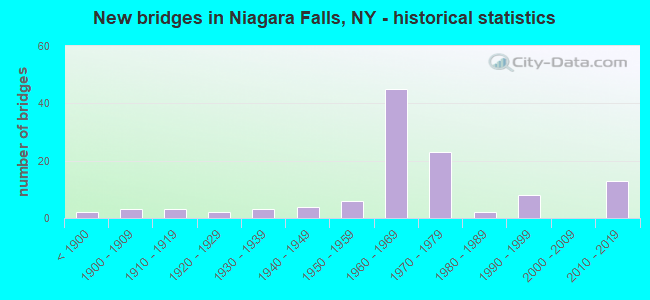
- New bridges - historical statistics
- 2Before 1900
- 31900-1909
- 31910-1919
- 21920-1929
- 31930-1939
- 41940-1949
- 61950-1959
- 451960-1969
- 231970-1979
- 21980-1989
- 81990-1999
- 132010-2019
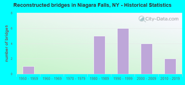
- Reconstructed bridges - Historical Statistics
- 11950-1959
- 01960-1969
- 01970-1979
- 51980-1989
- 61990-1999
- 42000-2009
- 22010-2019
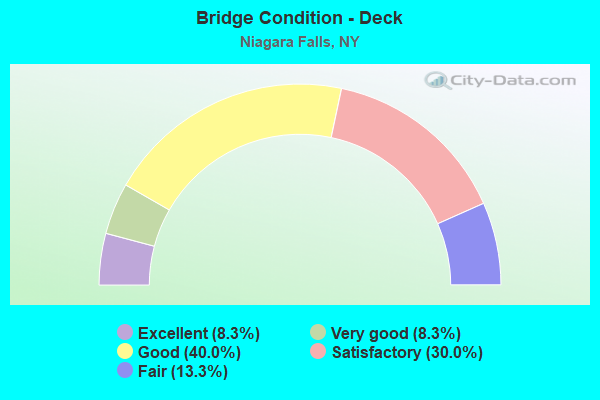
- Bridge Condition - Deck
- 8.3%Excellent
- 8.3%Very good
- 40.0%Good
- 30.0%Satisfactory
- 13.3%Fair
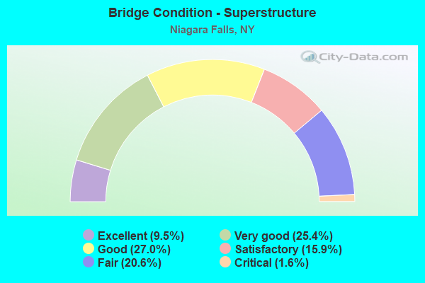
- Bridge Condition - Superstructure
- 9.5%Excellent
- 25.4%Very good
- 27.0%Good
- 15.9%Satisfactory
- 20.6%Fair
- 1.6%Critical
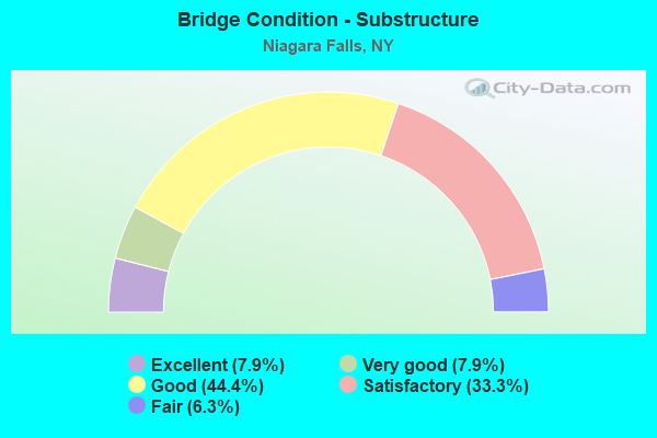
- Bridge Condition - Substructure
- 7.9%Excellent
- 7.9%Very good
- 44.4%Good
- 33.3%Satisfactory
- 6.3%Fair

- Bridge Condition - Channel
- 20.8%Very good
- 54.2%Good
- 25.0%Satisfactory
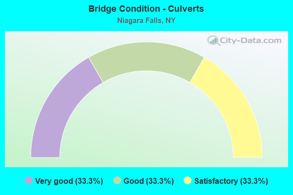
- Bridge Condition - Culverts
- 33.3%Very good
- 33.3%Good
- 33.3%Satisfactory
Find on map >> Show street view
Structure Number: 102856, Location: 0.3 MI E JCT RTS 62 + 265 (Lat: 43.091894, Lng: -78.962508), Route carried "on" structure: US 62, Year Built: 1993, Status: Open, Structure Length: 2.32m (7.61ft), Average Daily Traffic: 13,289 (year 2018), Truck Traffic: 3%, Average Future Daily Traffic: 13,351 (year 2040), Design Load: HS 20, Features Intersected: CAYUGA CREEK
Minimum Vertical Clearance: 30+ m (98+ ft), Kilometerpoint: 13.097, Lanes on structure: 4, Base Highway Network: Yes, Owner: State Highway Agency, Approaching Roadway Width: 21.9m (71.9ft), Skew: 20 degrees, Material/Design: Prestressed concrete, Design/Construction: Box Beam or Girders - Multiple, Number Of Spans In Main Unit: 1, Length of Maximum Span: 21.9m (71.9ft), Curb or Sidewalk Widths: Left: 1.5m (4.9ft), Right: 1.5m (4.9ft), Curb-To-Curb Width: 21.9m (71.9ft), Out-to-Out Width: 25.6m (84.0ft)
Condition: Deck: Satisfactory, Superstructure: Very good, Substructure: Very good, Channel: Good, Operating Rating: 82.6 metric tons, Method Used To Determine Operating Rating: Load Factor (LF), Inventory Rating: 32.7 metric tons, Method Used To Determine Inventory Rating: Load Factor (LF), Structural Evaluation: Equal to present desirable criteria, Deck Geometry: Superior to present desirable criteria, Waterway Adequacy: Equal to present minimum criteria, Approach Roadway Alignment: Equal to present desirable criteria, Length Of Structure Improvement: 2.31m (7.58ft), Designated Inspection Frequency: Every 24 months, Inspection Date: May 2021, Bridge Improvement Cost: $1,360,000, Roadway Improvement Cost: $796,000, Total Project Cost: $2,156,000 ( Estimate for 2021), Wearing Surface/Protective System: Wearing Surface: Integral Concrete
Find on map >> Show street view
Structure Number: 1028571, Location: JCT RTS 62 + I 190 (Lat: 43.089531, Lng: -78.990600), Route carried "on" structure: Interstate 190, Year Built: 1964, Status: Open, Structure Length: 5.09m (16.70ft), Average Daily Traffic: 22,074 (year 2014), Truck Traffic: 11%, Design Load: HS 20, Features Intersected: 62 62 54044024, RTE 62
Minimum Vertical Clearance: 30+ m (98+ ft), Kilometerpoint: 2.285, Lanes on structure: 2, Lanes under structure: 6, Base Highway Network: Yes, Owner: State Highway Agency, Approaching Roadway Width: 11.0m (36.1ft), Material/Design: Steel, Design/Construction: Stringer/Multi-beam, Number Of Spans In Main Unit: 4, Length of Maximum Span: 14.9m (48.9ft), Curb or Sidewalk Widths: Left: 0.5m (1.6ft), Right: 0.5m (1.6ft), Curb-To-Curb Width: 8.5m (27.9ft), Out-to-Out Width: 10.1m (33.1ft)
Condition: Deck: Satisfactory, Superstructure: Fair, Substructure: Satisfactory, Operating Rating: 41.8 metric tons, Method Used To Determine Operating Rating: Load and Resistance Factor Rating (LRFR) rating reported by rating factor(RF) method using HL-93 loadings, Inventory Rating: 32.4 metric tons, Method Used To Determine Inventory Rating: Load and Resistance Factor Rating (LRFR) rating reported by rating factor(RF) method using HL-93 loadings, Structural Evaluation: Somewhat better than minimum adequacy, Deck Geometry: High priority of replacement, Underclear: High priority of corrective action, Approach Roadway Alignment: Somewhat better than minimum adequacy, Length Of Structure Improvement: 5.09m (16.70ft), Designated Inspection Frequency: Every 24 months, Inspection Date: August 2020, Bridge Improvement Cost: $1,898,000, Roadway Improvement Cost: $1,111,000, Total Project Cost: $3,009,000 ( Estimate for 2021), Deck Structure Type: Concrete Cast-file-Place, Wearing Surface/Protective System: Wearing Surface: Monolithic Concrete
Find on map >> Show street view
Structure Number: 1028572, Location: JCT RTS 62 + I 190 (Lat: 43.089708, Lng: -78.990203), Route carried "on" structure: Interstate 190, Year Built: 1964, Status: Open, Structure Length: 5.09m (16.70ft), Average Daily Traffic: 15,062 (year 2019), Truck Traffic: 12%, Average Future Daily Traffic: 16,880 (year 2040), Design Load: HS 20, Features Intersected: 62 62 54044024, RTE 62
Minimum Vertical Clearance: 30+ m (98+ ft), Kilometerpoint: 2.285, Lanes on structure: 2, Lanes under structure: 6, Base Highway Network: Yes, Owner: State Highway Agency, Approaching Roadway Width: 11.0m (36.1ft), Material/Design: Steel, Design/Construction: Stringer/Multi-beam, Number Of Spans In Main Unit: 4, Length of Maximum Span: 14.9m (48.9ft), Curb or Sidewalk Widths: Left: 0.5m (1.6ft), Right: 0.5m (1.6ft), Curb-To-Curb Width: 8.5m (27.9ft), Out-to-Out Width: 10.1m (33.1ft)
Condition: Deck: Fair, Superstructure: Fair, Substructure: Satisfactory, Operating Rating: 41.8 metric tons, Method Used To Determine Operating Rating: Load and Resistance Factor Rating (LRFR) rating reported by rating factor(RF) method using HL-93 loadings, Inventory Rating: 32.4 metric tons, Method Used To Determine Inventory Rating: Load and Resistance Factor Rating (LRFR) rating reported by rating factor(RF) method using HL-93 loadings, Structural Evaluation: Somewhat better than minimum adequacy, Deck Geometry: High priority of replacement, Underclear: High priority of corrective action, Approach Roadway Alignment: Somewhat better than minimum adequacy, Length Of Structure Improvement: 5.09m (16.70ft), Designated Inspection Frequency: Every 24 months, Inspection Date: August 2020, Bridge Improvement Cost: $1,898,000, Roadway Improvement Cost: $1,111,000, Total Project Cost: $3,009,000 ( Estimate for 2021), Deck Structure Type: Concrete Cast-file-Place, Wearing Surface/Protective System: Wearing Surface: Monolithic Concrete
Find on map >> Show street view
Structure Number: 102858, Location: .6 MI W JCT US 62 & I190 (Lat: 43.091458, Lng: -79.002211), Route carried "on" structure: US 62, Year Built: 1964, Year Reconstructed: 1993, Status: Open, Structure Length: 5.88m (19.29ft), Average Daily Traffic: 17,744 (year 2019), Truck Traffic: 5%, Average Future Daily Traffic: 17,827 (year 2040), Design Load: HS 25 or greater, Features Intersected: CSXT
Minimum Vertical Clearance: 30+ m (98+ ft), Kilometerpoint: 16.444, Lanes on structure: 4, Base Highway Network: Yes, Owner: State Highway Agency, Approaching Roadway Width: 15.8m (51.8ft), Skew: 20 degrees, Material/Design: Steel continuous, Design/Construction: Stringer/Multi-beam, Number Of Spans In Main Unit: 3, Length of Maximum Span: 30.7m (100.7ft), Curb or Sidewalk Widths: Left: 2.1m (6.9ft), Right: 2.1m (6.9ft), Curb-To-Curb Width: 15.8m (51.8ft), Out-to-Out Width: 20.7m (67.9ft)
Condition: Deck: Good, Superstructure: Good, Substructure: Good, Operating Rating: 30.5 metric tons, Method Used To Determine Operating Rating: Load and Resistance Factor Rating (LRFR) rating reported by rating factor(RF) method using HL-93 loadings, Inventory Rating: 23.7 metric tons, Method Used To Determine Inventory Rating: Load and Resistance Factor Rating (LRFR) rating reported by rating factor(RF) method using HL-93 loadings, Structural Evaluation: Somewhat better than minimum adequacy, Deck Geometry: Meets minimum limits, Underclear: Better than present minimum criteria, Approach Roadway Alignment: Equal to present desirable criteria, Length Of Structure Improvement: 5.88m (19.29ft), Designated Inspection Frequency: Every 24 months, Inspection Date: September 2021, Bridge Improvement Cost: $5,569,000, Roadway Improvement Cost: $3,261,000, Total Project Cost: $8,830,000 ( Estimate for 2021), Deck Structure Type: Concrete Cast-file-Place, Wearing Surface/Protective System: Wearing Surface: Integral Concrete, Deck Protection: Epoxy Coated Reinforcing
Find on map >> Show street view
Structure Number: 10286, Location: 0.1 MI W JCT RTS 62 + 61 (Lat: 43.091506, Lng: -79.023661), Route carried "on" structure: US 62, Year Built: 1959, Status: Open, Structure Length: 2.32m (7.61ft), Average Daily Traffic: 8,817 (year 2019), Truck Traffic: 3%, Average Future Daily Traffic: 8,858 (year 2040), Design Load: HS 20, Features Intersected: GILL CREEK
Minimum Vertical Clearance: 30+ m (98+ ft), Kilometerpoint: 18.343, Lanes on structure: 2, Base Highway Network: Yes, Owner: State Highway Agency, Approaching Roadway Width: 10.4m (34.1ft), Skew: 5 degrees, Material/Design: Prestressed concrete, Design/Construction: Box Beam or Girders - Multiple, Number Of Spans In Main Unit: 2, Length of Maximum Span: 11.2m (36.7ft), Curb or Sidewalk Widths: Left: 4.7m (15.4ft), Right: 4.7m (15.4ft), Curb-To-Curb Width: 10.4m (34.1ft), Out-to-Out Width: 20.1m (65.9ft)
Condition: Superstructure: Fair, Substructure: Satisfactory, Channel: Good, Operating Rating: 25.6 metric tons, Method Used To Determine Operating Rating: Load and Resistance Factor Rating (LRFR) rating reported by rating factor(RF) method using HL-93 loadings, Inventory Rating: 19.8 metric tons, Method Used To Determine Inventory Rating: Load and Resistance Factor Rating (LRFR) rating reported by rating factor(RF) method using HL-93 loadings, Structural Evaluation: Somewhat better than minimum adequacy, Deck Geometry: Meets minimum limits, Waterway Adequacy: Somewhat better than minimum adequacy, Approach Roadway Alignment: Somewhat better than minimum adequacy, Length Of Structure Improvement: 2.31m (7.58ft), Designated Inspection Frequency: Every 24 months, Inspection Date: May 2021, Bridge Improvement Cost: $1,933,000, Roadway Improvement Cost: $1,132,000, Total Project Cost: $3,064,000 ( Estimate for 2021), Wearing Surface/Protective System: Wearing Surface: Bituminous, Membrane: Other
Find on map >> Show street view
Structure Number: 103627, Location: 0.1 MI S JCT RTS 104 & 61 (Lat: 43.133842, Lng: -79.044522), Route carried "on" structure: State highway 104, Year Built: 1960, Year Reconstructed: 1990, Status: Open, Structure Length: 2.62m (8.60ft), Average Daily Traffic: 3,013 (year 2019), Truck Traffic: 4%, Average Future Daily Traffic: 3,027 (year 2040), Design Load: HS 20, Features Intersected: INTERPLANT ROAD
Minimum Vertical Clearance: 30+ m (98+ ft), Kilometerpoint: 5.648, Lanes on structure: 4, Lanes under structure: 2, Base Highway Network: Yes, Owner: State Agenciy, Maintenance Responsibility: State Highway Agency, Approaching Roadway Width: 17.7m (58.1ft), Skew: 3 degrees, Material/Design: Prestressed concrete, Design/Construction: Box Beam or Girders - Multiple, Number Of Spans In Main Unit: 1, Length of Maximum Span: 24.6m (80.7ft), Curb or Sidewalk Widths: Left: 2.2m (7.2ft), Right: 2.2m (7.2ft), Curb-To-Curb Width: 17.7m (58.1ft), Out-to-Out Width: 22.6m (74.1ft)
Condition: Deck: Very good, Superstructure: Very good, Substructure: Good, Operating Rating: 89.8 metric tons, Method Used To Determine Operating Rating: Load Factor (LF), Inventory Rating: 50.8 metric tons, Method Used To Determine Inventory Rating: Load Factor (LF), Structural Evaluation: Better than present minimum criteria, Deck Geometry: Somewhat better than minimum adequacy, Underclear: High priority of corrective action, Approach Roadway Alignment: Equal to present desirable criteria, Length Of Structure Improvement: 2.62m (8.60ft), Designated Inspection Frequency: Every 24 months, Inspection Date: May 2021, Bridge Improvement Cost: $1,980,000, Roadway Improvement Cost: $1,160,000, Total Project Cost: $3,140,000 ( Estimate for 2021), Wearing Surface/Protective System: Wearing Surface: Monolithic Concrete
Find on map >> Show street view
Structure Number: 103629, Location: 0.5 MI N JCT RTS 104 & 61 (Lat: 43.144050, Lng: -79.039064), Route carried "on" structure: State highway 104, Year Built: 1960, Year Reconstructed: 1992, Status: Open, Structure Length: 54.38m (178.41ft), Average Daily Traffic: 5,819 (year 2020), Truck Traffic: 3%, Average Future Daily Traffic: 5,846 (year 2040), Features Intersected: RBT MOSES PWRPLNT
Minimum Vertical Clearance: 30+ m (98+ ft), Kilometerpoint: 6.484, Lanes on structure: 4, Base Highway Network: Yes, Owner: State Agenciy, Maintenance Responsibility: State Highway Agency, Approaching Roadway Width: 16.2m (53.1ft), Skew: 1 degrees, Material/Design: Prestressed concrete continuous, Design/Construction: Stringer/Multi-beam, Number Of Spans In Main Unit: 34, Length of Maximum Span: 27.7m (90.9ft), Curb or Sidewalk Widths: Left: 0.5m (1.6ft), Right: 2.3m (7.5ft), Curb-To-Curb Width: 15.8m (51.8ft), Out-to-Out Width: 18.3m (60.0ft)
Condition: Deck: Satisfactory, Superstructure: Fair, Substructure: Satisfactory, Operating Rating: 38.1 metric tons, Method Used To Determine Operating Rating: Load Factor (LF), Inventory Rating: 22.7 metric tons, Method Used To Determine Inventory Rating: Load Factor (LF), Structural Evaluation: Somewhat better than minimum adequacy, Deck Geometry: Meets minimum limits, Approach Roadway Alignment: Equal to present minimum criteria, Length Of Structure Improvement: 54.37m (178.38ft), Designated Inspection Frequency: Every 24 months, Inspection Date: January 2021, Bridge Improvement Cost: $32,865,000, Roadway Improvement Cost: $19,246,000, Total Project Cost: $52,111,000 ( Estimate for 2021), Deck Structure Type: Concrete Cast-file-Place, Wearing Surface/Protective System: Wearing Surface: Integral Concrete
Find on map >> Show street view
Structure Number: 10363, Location: .9 MI N JCT SH61 & SH 104 (Lat: 43.148231, Lng: -79.038967), Route carried "on" structure: State highway 104, Year Built: 1962, Status: Open, Structure Length: 1.89m (6.20ft), Average Daily Traffic: 5,819 (year 2020), Truck Traffic: 3%, Average Future Daily Traffic: 5,846 (year 2040), Features Intersected: EX-N.Y.CENTRAL RR
Minimum Vertical Clearance: 30+ m (98+ ft), Kilometerpoint: 7.401, Lanes on structure: 4, Base Highway Network: Yes, Owner: State Highway Agency, Approaching Roadway Width: 17.7m (58.1ft), Skew: 6 degrees, Material/Design: Concrete, Design/Construction: Frame, Number Of Spans In Main Unit: 1, Length of Maximum Span: 17.9m (58.7ft), Curb or Sidewalk Widths: Left: 1.0m (3.3ft), Right: 1.0m (3.3ft), Curb-To-Curb Width: 17.7m (58.1ft), Out-to-Out Width: 20.3m (66.6ft)
Condition: Deck: Very good, Superstructure: Very good, Substructure: Very good, Operating Rating: 85.4 metric tons, Method Used To Determine Operating Rating: Field evaluation and documented engineering judgment, Inventory Rating: 32.7 metric tons, Method Used To Determine Inventory Rating: Field evaluation and documented engineering judgment, Structural Evaluation: Equal to present desirable criteria, Deck Geometry: Somewhat better than minimum adequacy, Approach Roadway Alignment: Equal to present minimum criteria, Length Of Structure Improvement: 1.88m (6.17ft), Designated Inspection Frequency: Every 24 months, Inspection Date: July 2021, Bridge Improvement Cost: $6,673,000, Roadway Improvement Cost: $3,908,000, Total Project Cost: $10,580,000 ( Estimate for 2021)
Find on map >> Show street view
Structure Number: 103966, Location: 190I @ Exit 21 (Lat: 43.080706, Lng: -78.990819), Route carried "on" structure: Interstate 190, Year Built: 2010, Status: Open, Structure Length: 3.26m (10.70ft), Average Daily Traffic: 44,147 (year 2009), Truck Traffic: 10%, Average Future Daily Traffic: 61,806 (year 2029), Design Load: HS 25 or greater, Features Intersected: Lasalle Expy WB Ramp to,
Minimum Vertical Clearance: 30+ m (98+ ft), Kilometerpoint: 1.303, Lanes on structure: 6, Lanes under structure: 2, Base Highway Network: Yes, Owner: State Highway Agency, Approaching Roadway Width: 29.0m (95.1ft), Skew: 20 degrees, Material/Design: Concrete, Design/Construction: Culvert, Number Of Spans In Main Unit: 2, Length of Maximum Span: 14.6m (47.9ft), Curb-To-Curb Width: 43.8m (143.7ft), Out-to-Out Width: 44.7m (146.7ft)
Condition: Culverts: Very good, Inventory Rating: 60.7 metric tons, Method Used To Determine Inventory Rating: Load Factor (LF), Structural Evaluation: Equal to present desirable criteria, Deck Geometry: Superior to present desirable criteria, Underclear: Somewhat better than minimum adequacy, Approach Roadway Alignment: Equal to present desirable criteria, Length Of Structure Improvement: 3.26m (10.70ft), Designated Inspection Frequency: Every 24 months, Inspection Date: March 2021, Bridge Improvement Cost: $6,628,000, Roadway Improvement Cost: $3,881,000, Total Project Cost: $10,510,000 ( Estimate for 2021)
Find on map >> Show street view
Structure Number: 1039671, Location: 0.4 MI S JCT RT 190I& 384 (Lat: 43.085742, Lng: -78.990981), Route carried "on" structure: Interstate 190, Year Built: 1964, Status: Open, Structure Length: 3.54m (11.61ft), Average Daily Traffic: 22,074 (year 2009), Truck Traffic: 10%, Design Load: HS 20, Features Intersected: GIRARD AVENUE
Minimum Vertical Clearance: 30+ m (98+ ft), Kilometerpoint: 1.866, Lanes on structure: 3, Lanes under structure: 2, Base Highway Network: Yes, Owner: State Highway Agency, Approaching Roadway Width: 14.6m (47.9ft), Material/Design: Steel, Design/Construction: Stringer/Multi-beam, Number Of Spans In Main Unit: 3, Length of Maximum Span: 15.8m (51.8ft), Curb or Sidewalk Widths: Left: 0.5m (1.6ft), Right: 0.5m (1.6ft), Curb-To-Curb Width: 11.6m (38.1ft), Out-to-Out Width: 13.2m (43.3ft)
Condition: Deck: Good, Superstructure: Satisfactory, Substructure: Good, Operating Rating: 75.3 metric tons, Method Used To Determine Operating Rating: Load Factor (LF), Inventory Rating: 44.5 metric tons, Method Used To Determine Inventory Rating: Load Factor (LF), Structural Evaluation: Equal to present minimum criteria, Deck Geometry: High priority of replacement, Underclear: Somewhat better than minimum adequacy, Approach Roadway Alignment: Meets minimum limits, Length Of Structure Improvement: 3.53m (11.58ft), Designated Inspection Frequency: Every 24 months, Inspection Date: May 2020, Bridge Improvement Cost: $1,756,000, Roadway Improvement Cost: $1,028,000, Total Project Cost: $2,784,000 ( Estimate for 2021), Deck Structure Type: Concrete Cast-file-Place, Wearing Surface/Protective System: Wearing Surface: Monolithic Concrete
Find on map >> Show street view
Structure Number: 1039672, Location: 0.4 MI S JCT RT 190I& 384 (Lat: 43.085753, Lng: -78.990667), Route carried "on" structure: Interstate 190, Year Built: 1964, Year Reconstructed: 2003, Status: Open, Structure Length: 3.54m (11.61ft), Average Daily Traffic: 15,062 (year 2019), Truck Traffic: 10%, Average Future Daily Traffic: 16,880 (year 2040), Design Load: HS 20, Features Intersected: GIRARD AVENUE
Minimum Vertical Clearance: 30+ m (98+ ft), Kilometerpoint: 1.866, Lanes on structure: 3, Lanes under structure: 2, Base Highway Network: Yes, Owner: State Highway Agency, Approaching Roadway Width: 14.6m (47.9ft), Material/Design: Steel, Design/Construction: Stringer/Multi-beam, Number Of Spans In Main Unit: 3, Length of Maximum Span: 15.8m (51.8ft), Curb or Sidewalk Widths: Left: 0.5m (1.6ft), Right: 0.5m (1.6ft), Curb-To-Curb Width: 11.6m (38.1ft), Out-to-Out Width: 13.2m (43.3ft)
Condition: Deck: Satisfactory, Superstructure: Satisfactory, Substructure: Good, Operating Rating: 46.7 metric tons, Method Used To Determine Operating Rating: Load and Resistance Factor Rating (LRFR) rating reported by rating factor(RF) method using HL-93 loadings, Inventory Rating: 36.0 metric tons, Method Used To Determine Inventory Rating: Load and Resistance Factor Rating (LRFR) rating reported by rating factor(RF) method using HL-93 loadings, Structural Evaluation: Equal to present minimum criteria, Deck Geometry: High priority of replacement, Underclear: Equal to present minimum criteria, Approach Roadway Alignment: Meets minimum limits, Length Of Structure Improvement: 3.53m (11.58ft), Designated Inspection Frequency: Every 24 months, Inspection Date: May 2020, Bridge Improvement Cost: $1,756,000, Roadway Improvement Cost: $1,028,000, Total Project Cost: $2,784,000 ( Estimate for 2021), Deck Structure Type: Concrete Cast-file-Place, Wearing Surface/Protective System: Wearing Surface: Monolithic Concrete
Find on map >> Show street view
Structure Number: 1039691, Location: 0.9 MI N JCT RT 190I& 182 (Lat: 43.117825, Lng: -79.001103), Route carried "on" structure: Interstate 190, Year Built: 2012, Status: Open, Structure Length: 8.63m (28.31ft), Average Daily Traffic: 16,692 (year 2014), Truck Traffic: 10%, Design Load: HL 93, Features Intersected: CSXT/ATK
Minimum Vertical Clearance: 30+ m (98+ ft), Kilometerpoint: 6.243, Lanes on structure: 2, Base Highway Network: Yes, Owner: State Highway Agency, Approaching Roadway Width: 11.0m (36.1ft), Skew: 1 degrees, Material/Design: Steel continuous, Design/Construction: Stringer/Multi-beam, Number Of Spans In Main Unit: 2, Length of Maximum Span: 45.4m (149.0ft), Curb-To-Curb Width: 11.4m (37.4ft), Out-to-Out Width: 12.3m (40.4ft)
Condition: Deck: Excellent, Superstructure: Excellent, Substructure: Excellent, Operating Rating: 86.2 metric tons, Method Used To Determine Operating Rating: Load Factor (LF), Inventory Rating: 51.7 metric tons, Method Used To Determine Inventory Rating: Load Factor (LF), Structural Evaluation: Superior to present desirable criteria, Deck Geometry: Somewhat better than minimum adequacy, Underclear: Superior to present desirable criteria, Approach Roadway Alignment: Equal to present minimum criteria, Length Of Structure Improvement: 8.62m (28.28ft), Designated Inspection Frequency: Every 24 months, Inspection Date: November 2020, Bridge Improvement Cost: $3,784,000, Roadway Improvement Cost: $2,216,000, Total Project Cost: $6,000,000 ( Estimate for 2021), Deck Structure Type: Concrete Cast-file-Place, Wearing Surface/Protective System: Wearing Surface: Integral Concrete, Deck Protection: Epoxy Coated Reinforcing
Find on map >> Show street view
Structure Number: 1039692, Location: 0.9 MI N JCT RT 190I& 182 (Lat: 43.117881, Lng: -79.000786), Route carried "on" structure: Interstate 190, Year Built: 2012, Status: Open, Structure Length: 7.68m (25.20ft), Average Daily Traffic: 9,619 (year 2019), Truck Traffic: 12%, Average Future Daily Traffic: 10,780 (year 2040), Design Load: HL 93, Features Intersected: CSXT/ATK
Minimum Vertical Clearance: 30+ m (98+ ft), Kilometerpoint: 6.307, Lanes on structure: 2, Base Highway Network: Yes, Owner: State Highway Agency, Approaching Roadway Width: 11.3m (37.1ft), Skew: 2 degrees, Material/Design: Steel continuous, Design/Construction: Stringer/Multi-beam, Number Of Spans In Main Unit: 2, Length of Maximum Span: 39.9m (130.9ft), Curb-To-Curb Width: 11.4m (37.4ft), Out-to-Out Width: 12.4m (40.7ft)
Condition: Deck: Excellent, Superstructure: Excellent, Substructure: Excellent, Operating Rating: 85.3 metric tons, Method Used To Determine Operating Rating: Load Factor (LF), Inventory Rating: 50.8 metric tons, Method Used To Determine Inventory Rating: Load Factor (LF), Structural Evaluation: Superior to present desirable criteria, Deck Geometry: Somewhat better than minimum adequacy, Underclear: Superior to present desirable criteria, Approach Roadway Alignment: Equal to present minimum criteria, Length Of Structure Improvement: 7.68m (25.20ft), Designated Inspection Frequency: Every 24 months, Inspection Date: November 2020, Bridge Improvement Cost: $3,419,000, Roadway Improvement Cost: $2,002,000, Total Project Cost: $5,422,000 ( Estimate for 2021), Deck Structure Type: Concrete Cast-file-Place, Wearing Surface/Protective System: Wearing Surface: Integral Concrete, Deck Protection: Epoxy Coated Reinforcing
Find on map >> Show street view
Structure Number: 1039701, Location: 1.0 MI N JCT RT 190I& 182 (Lat: 43.119431, Lng: -79.003300), Route carried "on" structure: Interstate 190, Year Built: 2012, Status: Open, Structure Length: 4.24m (13.91ft), Average Daily Traffic: 16,692 (year 2014), Truck Traffic: 10%, Design Load: HL 93, Features Intersected: LOCKPORT ROAD
Minimum Vertical Clearance: 30+ m (98+ ft), Kilometerpoint: 6.549, Lanes on structure: 2, Lanes under structure: 2, Base Highway Network: Yes, Owner: State Highway Agency, Approaching Roadway Width: 11.3m (37.1ft), Skew: 3 degrees, Material/Design: Steel, Design/Construction: Stringer/Multi-beam, Number Of Spans In Main Unit: 1, Length of Maximum Span: 42.0m (137.8ft), Curb-To-Curb Width: 11.5m (37.7ft), Out-to-Out Width: 12.4m (40.7ft)
Condition: Deck: Good, Superstructure: Excellent, Substructure: Very good, Operating Rating: 79.8 metric tons, Method Used To Determine Operating Rating: Load Factor (LF), Inventory Rating: 47.2 metric tons, Method Used To Determine Inventory Rating: Load Factor (LF), Structural Evaluation: Equal to present desirable criteria, Deck Geometry: Somewhat better than minimum adequacy, Underclear: Equal to present minimum criteria, Approach Roadway Alignment: Better than present minimum criteria, Length Of Structure Improvement: 4.23m (13.88ft), Designated Inspection Frequency: Every 24 months, Inspection Date: June 2020, Bridge Improvement Cost: $2,093,000, Roadway Improvement Cost: $1,225,000, Total Project Cost: $3,318,000 ( Estimate for 2021), Deck Structure Type: Concrete Cast-file-Place, Wearing Surface/Protective System: Wearing Surface: Integral Concrete
Find on map >> Show street view
Structure Number: 1039702, Location: 1.0 MI N JCT RT 190I& 182 (Lat: 43.119494, Lng: -79.002928), Route carried "on" structure: Interstate 190, Year Built: 2012, Status: Open, Structure Length: 4.24m (13.91ft), Average Daily Traffic: 9,619 (year 2019), Truck Traffic: 12%, Average Future Daily Traffic: 10,780 (year 2040), Design Load: HL 93, Features Intersected: LOCKPORT ROAD
Minimum Vertical Clearance: 30+ m (98+ ft), Kilometerpoint: 6.549, Lanes on structure: 2, Lanes under structure: 2, Base Highway Network: Yes, Owner: State Highway Agency, Approaching Roadway Width: 9.4m (30.8ft), Skew: 3 degrees, Material/Design: Steel, Design/Construction: Stringer/Multi-beam, Number Of Spans In Main Unit: 1, Length of Maximum Span: 42.0m (137.8ft), Curb-To-Curb Width: 11.5m (37.7ft), Out-to-Out Width: 12.4m (40.7ft)
Condition: Deck: Good, Superstructure: Excellent, Substructure: Excellent, Operating Rating: 79.8 metric tons, Method Used To Determine Operating Rating: Load Factor (LF), Inventory Rating: 47.2 metric tons, Method Used To Determine Inventory Rating: Load Factor (LF), Structural Evaluation: Superior to present desirable criteria, Deck Geometry: Somewhat better than minimum adequacy, Underclear: Equal to present minimum criteria, Approach Roadway Alignment: Better than present minimum criteria, Length Of Structure Improvement: 4.23m (13.88ft), Designated Inspection Frequency: Every 24 months, Inspection Date: June 2020, Bridge Improvement Cost: $2,061,000, Roadway Improvement Cost: $1,207,000, Total Project Cost: $3,269,000 ( Estimate for 2021), Deck Structure Type: Concrete Cast-file-Place, Wearing Surface/Protective System: Wearing Surface: Monolithic Concrete
Find on map >> Show street view
Structure Number: 1039711, Location: 2.8 MI N JCT RT 190I & 31 (Lat: 43.135178, Lng: -79.020736), Route carried "on" structure: Interstate 190, Year Built: 1963, Status: Open, Structure Length: 2.29m (7.51ft), Average Daily Traffic: 14,056 (year 2014), Truck Traffic: 20%, Features Intersected: INTERPLANT ROAD
Minimum Vertical Clearance: 30+ m (98+ ft), Kilometerpoint: 8.978, Lanes on structure: 2, Lanes under structure: 2, Base Highway Network: Yes, Owner: State Highway Agency, Approaching Roadway Width: 12.2m (40.0ft), Skew: 1 degrees, Material/Design: Steel, Design/Construction: Stringer/Multi-beam, Number Of Spans In Main Unit: 1, Length of Maximum Span: 21.6m (70.9ft), Curb or Sidewalk Widths: Left: 0.5m (1.6ft), Right: 0.5m (1.6ft), Curb-To-Curb Width: 12.2m (40.0ft), Out-to-Out Width: 13.8m (45.3ft)
Condition: Deck: Good, Superstructure: Good, Substructure: Good, Operating Rating: 60.6 metric tons, Method Used To Determine Operating Rating: Load and Resistance Factor Rating (LRFR) rating reported by rating factor(RF) method using HL-93 loadings, Inventory Rating: 46.7 metric tons, Method Used To Determine Inventory Rating: Load and Resistance Factor Rating (LRFR) rating reported by rating factor(RF) method using HL-93 loadings, Structural Evaluation: Better than present minimum criteria, Deck Geometry: Better than present minimum criteria, Underclear: Equal to present minimum criteria, Approach Roadway Alignment: Equal to present minimum criteria, Length Of Structure Improvement: 2.28m (7.48ft), Designated Inspection Frequency: Every 24 months, Inspection Date: November 2020, Bridge Improvement Cost: $1,349,000, Roadway Improvement Cost: $790,000, Total Project Cost: $2,139,000 ( Estimate for 2021), Deck Structure Type: Concrete Cast-file-Place, Wearing Surface/Protective System: Wearing Surface: Monolithic Concrete
Find on map >> Show street view
Structure Number: 1039712, Location: 2.8 MI N JCT RT 190I & 31 (Lat: 43.135189, Lng: -79.020458), Route carried "on" structure: Interstate 190, Year Built: 1963, Status: Open, Structure Length: 2.29m (7.51ft), Average Daily Traffic: 7,097 (year 2020), Truck Traffic: 24%, Average Future Daily Traffic: 7,953 (year 2040), Features Intersected: INTERPLANT ROAD
Minimum Vertical Clearance: 30+ m (98+ ft), Kilometerpoint: 8.978, Lanes on structure: 2, Lanes under structure: 2, Base Highway Network: Yes, Owner: State Highway Agency, Approaching Roadway Width: 12.2m (40.0ft), Skew: 1 degrees, Material/Design: Steel, Design/Construction: Stringer/Multi-beam, Number Of Spans In Main Unit: 1, Length of Maximum Span: 21.6m (70.9ft), Curb or Sidewalk Widths: Left: 0.5m (1.6ft), Right: 0.5m (1.6ft), Curb-To-Curb Width: 12.2m (40.0ft), Out-to-Out Width: 13.8m (45.3ft)
Condition: Deck: Good, Superstructure: Good, Substructure: Satisfactory, Operating Rating: 60.6 metric tons, Method Used To Determine Operating Rating: Load and Resistance Factor Rating (LRFR) rating reported by rating factor(RF) method using HL-93 loadings, Inventory Rating: 46.7 metric tons, Method Used To Determine Inventory Rating: Load and Resistance Factor Rating (LRFR) rating reported by rating factor(RF) method using HL-93 loadings, Structural Evaluation: Equal to present minimum criteria, Deck Geometry: Better than present minimum criteria, Underclear: Somewhat better than minimum adequacy, Approach Roadway Alignment: Equal to present minimum criteria, Length Of Structure Improvement: 2.28m (7.48ft), Designated Inspection Frequency: Every 24 months, Inspection Date: November 2020, Bridge Improvement Cost: $1,349,000, Roadway Improvement Cost: $790,000, Total Project Cost: $2,139,000 ( Estimate for 2021), Deck Structure Type: Concrete Cast-file-Place, Wearing Surface/Protective System: Wearing Surface: Monolithic Concrete
Find on map >> Show street view
Structure Number: 1039729, Location: 3.3 MI N JCT RT 190I & 31 (Lat: 43.141600, Lng: -79.022425), Route carried "on" structure: Interstate 190, Year Built: 1963, Year Reconstructed: 2015, Status: Open, Structure Length: 24.93m (81.79ft), Average Daily Traffic: 14,193 (year 2020), Truck Traffic: 24%, Average Future Daily Traffic: 15,906 (year 2040), Design Load: HL 93, Features Intersected: POWER RESERVOIR
Minimum Vertical Clearance: 30+ m (98+ ft), Kilometerpoint: 9.751, Lanes on structure: 4, Base Highway Network: Yes, Owner: State Highway Agency, Approaching Roadway Width: 26.8m (87.9ft), Skew: 20 degrees, Material/Design: Steel continuous, Design/Construction: Stringer/Multi-beam, Number Of Spans In Main Unit: 12, Length of Maximum Span: 20.7m (67.9ft), Curb-To-Curb Width: 26.8m (87.9ft), Out-to-Out Width: 28.8m (94.5ft)
Condition: Deck: Very good, Superstructure: Very good, Substructure: Satisfactory, Channel: Very good, Operating Rating: 87.1 metric tons, Method Used To Determine Operating Rating: Load Testing, Inventory Rating: 51.7 metric tons, Method Used To Determine Inventory Rating: Load Testing, Structural Evaluation: Equal to present minimum criteria, Deck Geometry: Superior to present desirable criteria, Waterway Adequacy: Equal to present desirable criteria, Approach Roadway Alignment: Equal to present desirable criteria, Length Of Structure Improvement: 24.93m (81.79ft), Designated Inspection Frequency: Every 24 months, Underwater Inspection Frequency: Every 60 months, Inspection Date: November 2021, Underwater Inspection Date: January 2021, Bridge Improvement Cost: $33,835,000, Roadway Improvement Cost: $19,814,000, Total Project Cost: $53,649,000 ( Estimate for 2021), Deck Structure Type: Concrete Cast-file-Place, Wearing Surface/Protective System: Wearing Surface: Integral Concrete, Deck Protection: Epoxy Coated Reinforcing
Find on map >> Show street view
Structure Number: 106018, Location: 0.9 MI N JCT RTS 61 + 384 (Lat: 43.093639, Lng: -79.023500), Route carried "on" structure: State highway 61, Year Built: 1950, Year Reconstructed: 1962, Status: Open, Structure Length: 1.25m (4.10ft), Average Daily Traffic: 5,363 (year 2019), Truck Traffic: 3%, Average Future Daily Traffic: 5,388 (year 2040), Features Intersected: GILL CREEK
Minimum Vertical Clearance: 30+ m (98+ ft), Kilometerpoint: 1.319, Lanes on structure: 4, Base Highway Network: Yes, Owner: State Highway Agency, Approaching Roadway Width: 21.9m (71.9ft), Skew: 24 degrees, Material/Design: Concrete continuous, Design/Construction: Culvert, Number Of Spans In Main Unit: 2, Length of Maximum Span: 6.0m (19.7ft), Curb or Sidewalk Widths: Left: 1.5m (4.9ft), Right: 1.5m (4.9ft), Curb-To-Curb Width: 21.9m (71.9ft), Out-to-Out Width: 51.2m (168.0ft)
Condition: Channel: Very good, Culverts: Satisfactory, Operating Rating: 74.1 metric tons, Method Used To Determine Operating Rating: Field evaluation and documented engineering judgment, Inventory Rating: 32.7 metric tons, Method Used To Determine Inventory Rating: Field evaluation and documented engineering judgment, Structural Evaluation: Equal to present minimum criteria, Deck Geometry: Superior to present desirable criteria, Waterway Adequacy: Meets minimum limits, Approach Roadway Alignment: Somewhat better than minimum adequacy, Length Of Structure Improvement: 1.24m (4.07ft), Designated Inspection Frequency: Every 24 months, Inspection Date: April 2020, Bridge Improvement Cost: $1,768,000, Roadway Improvement Cost: $1,035,000, Total Project Cost: $2,803,000 ( Estimate for 2021), Wearing Surface/Protective System: Wearing Surface: Bituminous
Find on map >> Show street view
Structure Number: 106019, Location: 2.3 MI N JCT SH61 & SH384 (Lat: 43.112508, Lng: -79.032075), Route carried "on" structure: State highway 61, Year Built: 1964, Year Reconstructed: 1997, Status: Open, Structure Length: 10.82m (35.50ft), Average Daily Traffic: 8,504 (year 2019), Truck Traffic: 2%, Average Future Daily Traffic: 8,543 (year 2040), Design Load: HS 20, Features Intersected: CSXT/ATK
Minimum Vertical Clearance: 30+ m (98+ ft), Kilometerpoint: 3.492, Lanes on structure: 4, Base Highway Network: Yes, Owner: State Highway Agency, Approaching Roadway Width: 21.9m (71.9ft), Skew: 21 degrees, Material/Design: Steel, Design/Construction: Stringer/Multi-beam, Number Of Spans In Main Unit: 6, Length of Maximum Span: 20.7m (67.9ft), Curb or Sidewalk Widths: Left: 2.7m (8.9ft), Right: 2.7m (8.9ft), Curb-To-Curb Width: 21.9m (71.9ft), Out-to-Out Width: 28.0m (91.9ft)
Condition: Deck: Good, Superstructure: Satisfactory, Substructure: Good, Operating Rating: 49.9 metric tons, Method Used To Determine Operating Rating: Load Factor (LF), Inventory Rating: 30.8 metric tons, Method Used To Determine Inventory Rating: Load Factor (LF), Structural Evaluation: Equal to present minimum criteria, Deck Geometry: Superior to present desirable criteria, Underclear: Somewhat better than minimum adequacy, Approach Roadway Alignment: Equal to present desirable criteria, Length Of Structure Improvement: 10.82m (35.50ft), Designated Inspection Frequency: Every 24 months, Inspection Date: December 2020, Bridge Improvement Cost: $10,443,000, Roadway Improvement Cost: $6,116,000, Total Project Cost: $16,559,000 ( Estimate for 2021), Deck Structure Type: Concrete Cast-file-Place, Wearing Surface/Protective System: Wearing Surface: Integral Concrete
Find on map >> Show street view
Structure Number: 1064909, Location: 0.1 MI E JCT RT 951A&190I (Lat: 43.080142, Lng: -78.981744), Route carried "on" structure: State highway 951A, Year Built: 1970, Status: Open, Structure Length: 2.74m (8.99ft), Average Daily Traffic: 11,538 (year 2019), Truck Traffic: 3%, Average Future Daily Traffic: 13,370 (year 2040), Features Intersected: 72ND STREET
Minimum Vertical Clearance: 30+ m (98+ ft), Kilometerpoint: 1.014, Lanes on structure: 7, Lanes under structure: 2, Base Highway Network: Yes, Owner: State Highway Agency, Approaching Roadway Width: 34.7m (113.8ft), Skew: 20 degrees, Material/Design: Steel, Design/Construction: Stringer/Multi-beam, Number Of Spans In Main Unit: 1, Length of Maximum Span: 25.9m (85.0ft), Curb-To-Curb Width: 38.1m (125.0ft), Out-to-Out Width: 39.9m (130.9ft)
Condition: Deck: Satisfactory, Superstructure: Very good, Substructure: Satisfactory, Operating Rating: 76.1 metric tons, Method Used To Determine Operating Rating: Load and Resistance Factor Rating (LRFR) rating reported by rating factor(RF) method using HL-93 loadings, Inventory Rating: 59.0 metric tons, Method Used To Determine Inventory Rating: Load and Resistance Factor Rating (LRFR) rating reported by rating factor(RF) method using HL-93 loadings, Structural Evaluation: Equal to present minimum criteria, Deck Geometry: Superior to present desirable criteria, Underclear: Somewhat better than minimum adequacy, Approach Roadway Alignment: Somewhat better than minimum adequacy, Length Of Structure Improvement: 2.74m (8.99ft), Designated Inspection Frequency: Every 24 months, Inspection Date: May 2020, Bridge Improvement Cost: $5,961,000, Roadway Improvement Cost: $3,490,000, Total Project Cost: $9,451,000 ( Estimate for 2021), Deck Structure Type: Concrete Cast-file-Place, Wearing Surface/Protective System: Wearing Surface: Bituminous
Find on map >> Show street view
Structure Number: 1064919, Location: 0.1 MI E JCT RT 951A&190I (Lat: 43.079750, Lng: -78.975992), Route carried "on" structure: State highway 951A, Year Built: 1970, Status: Open, Structure Length: 3.05m (10.01ft), Average Daily Traffic: 11,538 (year 2019), Truck Traffic: 3%, Average Future Daily Traffic: 13,370 (year 2040), Features Intersected: 77TH STREET
Minimum Vertical Clearance: 30+ m (98+ ft), Kilometerpoint: 1.496, Lanes on structure: 5, Lanes under structure: 4, Base Highway Network: Yes, Owner: State Highway Agency, Approaching Roadway Width: 25.6m (84.0ft), Skew: 20 degrees, Material/Design: Steel, Design/Construction: Stringer/Multi-beam, Number Of Spans In Main Unit: 1, Length of Maximum Span: 28.9m (94.8ft), Curb-To-Curb Width: 34.1m (111.9ft), Out-to-Out Width: 36.0m (118.1ft)
Condition: Deck: Satisfactory, Superstructure: Very good, Substructure: Fair, Operating Rating: 65.1 metric tons, Method Used To Determine Operating Rating: Load and Resistance Factor Rating (LRFR) rating reported by rating factor(RF) method using HL-93 loadings, Inventory Rating: 50.2 metric tons, Method Used To Determine Inventory Rating: Load and Resistance Factor Rating (LRFR) rating reported by rating factor(RF) method using HL-93 loadings, Structural Evaluation: Somewhat better than minimum adequacy, Deck Geometry: Superior to present desirable criteria, Underclear: Meets minimum limits, Approach Roadway Alignment: Equal to present minimum criteria, Length Of Structure Improvement: 3.04m (9.97ft), Designated Inspection Frequency: Every 24 months, Inspection Date: May 2020, Bridge Improvement Cost: $5,867,000, Roadway Improvement Cost: $3,436,000, Total Project Cost: $9,303,000 ( Estimate for 2021), Deck Structure Type: Concrete Cast-file-Place, Wearing Surface/Protective System: Wearing Surface: Bituminous
Find on map >> Show street view
Structure Number: 106492, Location: 1.5 MI E JCT RT 951A&190I (Lat: 43.079039, Lng: -78.963856), Route carried "on" structure: Ramp State highway 951A, Year Built: 1970, Status: Open, Structure Length: 2.68m (8.79ft), Average Daily Traffic: 1,369 (year 2019), Truck Traffic: 4%, Average Future Daily Traffic: 1,586 (year 2040), Features Intersected: 87TH STREET
Minimum Vertical Clearance: 30+ m (98+ ft), Kilometerpoint: 0.225, Lanes on structure: 1, Lanes under structure: 3, Owner: State Highway Agency, Approaching Roadway Width: 6.1m (20.0ft), Material/Design: Steel, Design/Construction: Stringer/Multi-beam, Number Of Spans In Main Unit: 1, Length of Maximum Span: 25.6m (84.0ft), Curb or Sidewalk Widths: Left: 0.6m (2.0ft), Right: 0.6m (2.0ft), Curb-To-Curb Width: 6.1m (20.0ft), Out-to-Out Width: 7.9m (25.9ft)
Condition: Deck: Good, Superstructure: Very good, Substructure: Good, Operating Rating: 93.4 metric tons, Method Used To Determine Operating Rating: Load Factor (LF), Inventory Rating: 56.2 metric tons, Method Used To Determine Inventory Rating: Load Factor (LF), Structural Evaluation: Better than present minimum criteria, Deck Geometry: Somewhat better than minimum adequacy, Underclear: Meets minimum limits, Approach Roadway Alignment: Somewhat better than minimum adequacy, Length Of Structure Improvement: 2.68m (8.79ft), Designated Inspection Frequency: Every 24 months, Inspection Date: March 2021, Bridge Improvement Cost: $1,232,000, Roadway Improvement Cost: $721,000, Total Project Cost: $1,953,000 ( Estimate for 2021), Deck Structure Type: Concrete Cast-file-Place, Wearing Surface/Protective System: Wearing Surface: Bituminous
Find on map >> Show street view
Structure Number: 1064939, Location: 1.5 MI E JCT RT 951A&190I (Lat: 43.078717, Lng: -78.963858), Route carried "on" structure: State highway 951A, Year Built: 1970, Status: Open, Structure Length: 2.71m (8.89ft), Average Daily Traffic: 12,645 (year 2020), Truck Traffic: 3%, Average Future Daily Traffic: 14,653 (year 2040), Features Intersected: 87TH STREET
Minimum Vertical Clearance: 30+ m (98+ ft), Kilometerpoint: 2.719, Lanes on structure: 5, Lanes under structure: 2, Base Highway Network: Yes, Owner: State Highway Agency, Approaching Roadway Width: 26.8m (87.9ft), Skew: 21 degrees, Material/Design: Steel, Design/Construction: Stringer/Multi-beam, Number Of Spans In Main Unit: 1, Length of Maximum Span: 25.9m (85.0ft), Curb-To-Curb Width: 34.1m (111.9ft), Out-to-Out Width: 36.0m (118.1ft)
Condition: Deck: Satisfactory, Superstructure: Good, Substructure: Good, Operating Rating: 92.5 metric tons, Method Used To Determine Operating Rating: Load Factor (LF), Inventory Rating: 55.3 metric tons, Method Used To Determine Inventory Rating: Load Factor (LF), Structural Evaluation: Better than present minimum criteria, Deck Geometry: Superior to present desirable criteria, Underclear: Equal to present minimum criteria, Approach Roadway Alignment: Equal to present minimum criteria, Length Of Structure Improvement: 2.71m (8.89ft), Designated Inspection Frequency: Every 24 months, Inspection Date: April 2021, Bridge Improvement Cost: $5,797,000, Roadway Improvement Cost: $3,395,000, Total Project Cost: $9,192,000 ( Estimate for 2021), Deck Structure Type: Concrete Cast-file-Place, Wearing Surface/Protective System: Wearing Surface: Bituminous
Find on map >> Show street view
Structure Number: 106494, Location: 1.5 MI E JCT RT 951A&190I (Lat: 43.078506, Lng: -78.963814), Route carried "on" structure: Ramp State highway 951A, Year Built: 1970, Status: Open, Structure Length: 2.83m (9.28ft), Average Daily Traffic: 1,312 (year 2019), Truck Traffic: 4%, Average Future Daily Traffic: 1,520 (year 2040), Features Intersected: 87TH STREET
Minimum Vertical Clearance: 30+ m (98+ ft), Kilometerpoint: 0.209, Lanes on structure: 1, Lanes under structure: 2, Owner: State Highway Agency, Approaching Roadway Width: 6.1m (20.0ft), Skew: 1 degrees, Material/Design: Steel, Design/Construction: Stringer/Multi-beam, Number Of Spans In Main Unit: 1, Length of Maximum Span: 26.8m (87.9ft), Curb or Sidewalk Widths: Left: 0.6m (2.0ft), Right: 0.6m (2.0ft), Curb-To-Curb Width: 6.1m (20.0ft), Out-to-Out Width: 7.9m (25.9ft)
Condition: Deck: Good, Superstructure: Very good, Substructure: Good, Operating Rating: 91.6 metric tons, Method Used To Determine Operating Rating: Load Factor (LF), Inventory Rating: 54.4 metric tons, Method Used To Determine Inventory Rating: Load Factor (LF), Structural Evaluation: Better than present minimum criteria, Deck Geometry: Somewhat better than minimum adequacy, Underclear: Meets minimum limits, Approach Roadway Alignment: Equal to present minimum criteria, Length Of Structure Improvement: 2.83m (9.28ft), Designated Inspection Frequency: Every 24 months, Inspection Date: May 2021, Bridge Improvement Cost: $1,265,000, Roadway Improvement Cost: $741,000, Total Project Cost: $2,006,000 ( Estimate for 2021), Deck Structure Type: Concrete Cast-file-Place, Wearing Surface/Protective System: Wearing Surface: Bituminous
Find on map >> Show street view
Structure Number: 1064959, Location: 1.6 MI E JCT RT 951A&190I (Lat: 43.078697, Lng: -78.961036), Route carried "on" structure: State highway 951A, Year Built: 1970, Status: Open, Structure Length: 14.39m (47.21ft), Average Daily Traffic: 12,645 (year 2020), Truck Traffic: 4%, Average Future Daily Traffic: 14,653 (year 2040), Design Load: HS 20, Features Intersected: CAYUGA DRIVE, CAYUGA CR
Minimum Vertical Clearance: 30+ m (98+ ft), Kilometerpoint: 2.896, Lanes on structure: 4, Lanes under structure: 2, Base Highway Network: Yes, Owner: State Highway Agency, Approaching Roadway Width: 25.6m (84.0ft), Skew: 23 degrees, Material/Design: Steel continuous, Design/Construction: Stringer/Multi-beam, Number Of Spans In Main Unit: 4, Length of Maximum Span: 40.5m (132.9ft), Curb-To-Curb Width: 34.2m (112.2ft), Out-to-Out Width: 35.9m (117.8ft)
Condition: Deck: Satisfactory, Superstructure: Fair, Substructure: Satisfactory, Channel: Satisfactory, Operating Rating: 55.3 metric tons, Method Used To Determine Operating Rating: Load Factor (LF), Inventory Rating: 32.7 metric tons, Method Used To Determine Inventory Rating: Load Factor (LF), Structural Evaluation: Somewhat better than minimum adequacy, Deck Geometry: Superior to present desirable criteria, Underclear: Somewhat better than minimum adequacy, Waterway Adequacy: Superior to present desirable criteria, Approach Roadway Alignment: Equal to present desirable criteria, Length Of Structure Improvement: 14.38m (47.18ft), Designated Inspection Frequency: Every 24 months, Inspection Date: August 2020, Bridge Improvement Cost: $17,978,000, Roadway Improvement Cost: $10,528,000, Total Project Cost: $28,506,000 ( Estimate for 2021), Deck Structure Type: Concrete Cast-file-Place, Wearing Surface/Protective System: Wearing Surface: Monolithic Concrete
Find on map >> Show street view
Structure Number: 1064969, Location: 1.8 MI E JCT RT 951A&190I (Lat: 43.078269, Lng: -78.957583), Route carried "on" structure: State highway 951A, Year Built: 1970, Status: Open, Structure Length: 2.74m (8.99ft), Average Daily Traffic: 8,095 (year 2019), Truck Traffic: 4%, Average Future Daily Traffic: 9,380 (year 2040), Features Intersected: RTE 265X
Minimum Vertical Clearance: 30+ m (98+ ft), Kilometerpoint: 3.234, Lanes on structure: 5, Lanes under structure: 2, Base Highway Network: Yes, Owner: State Highway Agency, Approaching Roadway Width: 27.1m (88.9ft), Skew: 20 degrees, Material/Design: Steel, Design/Construction: Stringer/Multi-beam, Number Of Spans In Main Unit: 1, Length of Maximum Span: 25.9m (85.0ft), Curb-To-Curb Width: 34.1m (111.9ft), Out-to-Out Width: 36.0m (118.1ft)
Condition: Deck: Good, Superstructure: Very good, Substructure: Satisfactory, Operating Rating: 71.6 metric tons, Method Used To Determine Operating Rating: Load and Resistance Factor Rating (LRFR) rating reported by rating factor(RF) method using HL-93 loadings, Inventory Rating: 55.4 metric tons, Method Used To Determine Inventory Rating: Load and Resistance Factor Rating (LRFR) rating reported by rating factor(RF) method using HL-93 loadings, Structural Evaluation: Equal to present minimum criteria, Deck Geometry: Superior to present desirable criteria, Underclear: Somewhat better than minimum adequacy, Approach Roadway Alignment: Equal to present minimum criteria, Length Of Structure Improvement: 2.74m (8.99ft), Designated Inspection Frequency: Every 24 months, Inspection Date: May 2020, Bridge Improvement Cost: $5,816,000, Roadway Improvement Cost: $3,406,000, Total Project Cost: $9,222,000 ( Estimate for 2021), Deck Structure Type: Concrete Cast-file-Place, Wearing Surface/Protective System: Wearing Surface: Bituminous
Find on map >> Show street view
Structure Number: 1064979, Location: 2.5 MI E JCT RT 951A&190I (Lat: 43.074481, Lng: -78.945392), Route carried "on" structure: State highway 951A, Year Built: 1970, Status: Open, Structure Length: 2.71m (8.89ft), Average Daily Traffic: 8,095 (year 2019), Truck Traffic: 4%, Average Future Daily Traffic: 9,380 (year 2040), Features Intersected: 102ND STREET
Minimum Vertical Clearance: 30+ m (98+ ft), Kilometerpoint: 4.087, Lanes on structure: 4, Lanes under structure: 2, Base Highway Network: Yes, Owner: State Highway Agency, Approaching Roadway Width: 24.7m (81.0ft), Skew: 22 degrees, Material/Design: Steel, Design/Construction: Stringer/Multi-beam, Number Of Spans In Main Unit: 1, Length of Maximum Span: 25.9m (85.0ft), Curb-To-Curb Width: 36.1m (118.4ft), Out-to-Out Width: 38.1m (125.0ft)
Condition: Deck: Fair, Superstructure: Good, Substructure: Satisfactory, Operating Rating: 52.2 metric tons, Method Used To Determine Operating Rating: Load and Resistance Factor Rating (LRFR) rating reported by rating factor(RF) method using HL-93 loadings, Inventory Rating: 40.2 metric tons, Method Used To Determine Inventory Rating: Load and Resistance Factor Rating (LRFR) rating reported by rating factor(RF) method using HL-93 loadings, Structural Evaluation: Equal to present minimum criteria, Deck Geometry: Superior to present desirable criteria, Underclear: Equal to present minimum criteria, Approach Roadway Alignment: Equal to present minimum criteria, Length Of Structure Improvement: 2.71m (8.89ft), Designated Inspection Frequency: Every 24 months, Inspection Date: May 2020, Bridge Improvement Cost: $6,293,000, Roadway Improvement Cost: $3,685,000, Total Project Cost: $9,978,000 ( Estimate for 2021), Deck Structure Type: Concrete Cast-file-Place, Wearing Surface/Protective System: Wearing Surface: Bituminous
Find on map >> Show street view
Structure Number: 1064999, Location: 0.2 MI E JCT RT 384& 190I (Lat: 43.075286, Lng: -78.987900), Route carried "on" structure: State highway 951A, Year Built: 1970, Status: Open, Structure Length: 3.47m (11.38ft), Average Daily Traffic: 3,297 (year 2019), Truck Traffic: 1%, Average Future Daily Traffic: 3,820 (year 2040), Design Load: HS 20+Mod, Features Intersected: RTE 384
Minimum Vertical Clearance: 30+ m (98+ ft), Kilometerpoint: 0.306, Lanes on structure: 4, Lanes under structure: 4, Base Highway Network: Yes, Owner: State Park, Forest, or Reservation Agency, Maintenance Responsibility: State Highway Agency, Approaching Roadway Width: 23.2m (76.1ft), Skew: 21 degrees, Material/Design: Steel, Design/Construction: Stringer/Multi-beam, Number Of Spans In Main Unit: 1, Length of Maximum Span: 33.5m (109.9ft), Curb-To-Curb Width: 24.1m (79.1ft), Out-to-Out Width: 25.0m (82.0ft)
Condition: Deck: Good, Superstructure: Very good, Substructure: Good, Operating Rating: 69.9 metric tons, Method Used To Determine Operating Rating: Load Factor (LF), Inventory Rating: 41.7 metric tons, Method Used To Determine Inventory Rating: Load Factor (LF), Structural Evaluation: Better than present minimum criteria, Deck Geometry: Superior to present desirable criteria, Underclear: Somewhat better than minimum adequacy, Approach Roadway Alignment: Equal to present desirable criteria, Length Of Structure Improvement: 3.47m (11.38ft), Designated Inspection Frequency: Every 24 months, Inspection Date: April 2020, Bridge Improvement Cost: $4,595,000, Roadway Improvement Cost: $2,691,000, Total Project Cost: $7,286,000 ( Estimate for 2021), Deck Structure Type: Concrete Cast-file-Place, Wearing Surface/Protective System: Wearing Surface: Integral Concrete
Find on map >> Show street view
Structure Number: 106807, Location: 957A AT JCT RT 190I & 384 (Lat: 43.074636, Lng: -78.993767), Route carried "on" structure: City street 957A, Year Built: 1960, Year Reconstructed: 2021, Status: Open, Structure Length: 3.78m (12.40ft), Average Daily Traffic: 6,076 (year 2019), Truck Traffic: 2%, Average Future Daily Traffic: 7,040 (year 2040), Design Load: HS 20, Features Intersected: 957A OFF RAMP EB
Minimum Vertical Clearance: 30+ m (98+ ft), Kilometerpoint: 0.225, Lanes on structure: 2, Lanes under structure: 2, Base Highway Network: Yes, Owner: State Agenciy, Maintenance Responsibility: State Highway Agency, Approaching Roadway Width: 7.3m (24.0ft), Skew: 3 degrees, Material/Design: Steel, Design/Construction: Stringer/Multi-beam, Number Of Spans In Main Unit: 3, Length of Maximum Span: 15.2m (49.9ft), Curb or Sidewalk Widths: Left: 1.1m (3.6ft), Right: 1.1m (3.6ft), Curb-To-Curb Width: 7.3m (24.0ft), Out-to-Out Width: 10.1m (33.1ft)
Condition: Deck: Very good, Superstructure: Good, Substructure: Very good, Operating Rating: 67.1 metric tons, Method Used To Determine Operating Rating: Load Factor (LF), Inventory Rating: 39.9 metric tons, Method Used To Determine Inventory Rating: Load Factor (LF), Structural Evaluation: Better than present minimum criteria, Deck Geometry: High priority of replacement, Underclear: High priority of corrective action, Approach Roadway Alignment: Equal to present minimum criteria, Length Of Structure Improvement: 3.77m (12.37ft), Designated Inspection Frequency: Every 24 months, Inspection Date: October 2021, Bridge Improvement Cost: $1,234,000, Roadway Improvement Cost: $723,000, Total Project Cost: $1,957,000 ( Estimate for 2021), Deck Structure Type: Concrete Cast-file-Place, Wearing Surface/Protective System: Wearing Surface: Integral Concrete, Deck Protection: Epoxy Coated Reinforcing
Find on map >> Show street view
Structure Number: 1068089, Location: 0.7 MI W JCT RT 957A&190I (Lat: 43.074714, Lng: -79.003758), Route carried "on" structure: State highway 957A, Year Built: 1962, Status: Open, Structure Length: 1.46m (4.79ft), Average Daily Traffic: 12,760 (year 2018), Truck Traffic: 3%, Average Future Daily Traffic: 14,786 (year 2040), Features Intersected: DOCK ACCESS ROAD
Minimum Vertical Clearance: 30+ m (98+ ft), Kilometerpoint: 1.046, Lanes on structure: 4, Lanes under structure: 2, Base Highway Network: Yes, Owner: State Agenciy, Maintenance Responsibility: State Highway Agency, Approaching Roadway Width: 14.6m (47.9ft), Skew: 21 degrees, Material/Design: Concrete, Design/Construction: Frame, Number Of Spans In Main Unit: 1, Length of Maximum Span: 13.7m (44.9ft), Curb-To-Curb Width: 31.7m (104.0ft), Out-to-Out Width: 33.3m (109.3ft)
Condition: Deck: Good, Superstructure: Very good, Substructure: Good, Operating Rating: 82.4 metric tons, Method Used To Determine Operating Rating: Field evaluation and documented engineering judgment, Inventory Rating: 32.7 metric tons, Method Used To Determine Inventory Rating: Field evaluation and documented engineering judgment, Structural Evaluation: Better than present minimum criteria, Deck Geometry: Superior to present desirable criteria, Underclear: High priority of corrective action, Approach Roadway Alignment: Equal to present minimum criteria, Length Of Structure Improvement: 1.46m (4.79ft), Designated Inspection Frequency: Every 24 months, Inspection Date: July 2020, Bridge Improvement Cost: $3,176,000, Roadway Improvement Cost: $1,860,000, Total Project Cost: $5,035,000 ( Estimate for 2021), Wearing Surface/Protective System: Wearing Surface: Bituminous
Find on map >> Show street view
Structure Number: 1068119, Location: 0.9 MI W JCT RT 957A&190I (Lat: 43.078344, Lng: -79.020242), Route carried "on" structure: State highway 957A, Year Built: 1962, Status: Open, Structure Length: 4.63m (15.19ft), Average Daily Traffic: 12,760 (year 2018), Truck Traffic: 3%, Average Future Daily Traffic: 14,786 (year 2040), Features Intersected: STOP LOG STRUCT.
Minimum Vertical Clearance: 30+ m (98+ ft), Kilometerpoint: 2.446, Lanes on structure: 3, Base Highway Network: Yes, Owner: State Agenciy, Maintenance Responsibility: State Highway Agency, Approaching Roadway Width: 14.6m (47.9ft), Material/Design: Concrete continuous, Design/Construction: Slab, Number Of Spans In Main Unit: 6, Length of Maximum Span: 7.6m (24.9ft), Curb or Sidewalk Widths: Left: 3.3m (10.8ft), Right: 0.0m, Curb-To-Curb Width: 10.4m (34.1ft), Out-to-Out Width: 19.8m (65.0ft)
Condition: Deck: Good, Superstructure: Good, Substructure: Good, Operating Rating: 78.0 metric tons, Method Used To Determine Operating Rating: Field evaluation and documented engineering judgment, Inventory Rating: 32.7 metric tons, Method Used To Determine Inventory Rating: Field evaluation and documented engineering judgment, Structural Evaluation: Better than present minimum criteria, Deck Geometry: High priority of replacement, Approach Roadway Alignment: Equal to present minimum criteria, Length Of Structure Improvement: 4.63m (15.19ft), Designated Inspection Frequency: Every 24 months, Inspection Date: June 2020, Bridge Improvement Cost: $2,446,000, Roadway Improvement Cost: $1,433,000, Total Project Cost: $3,879,000 ( Estimate for 2021), Wearing Surface/Protective System: Wearing Surface: Bituminous
Find on map >> Show street view
Structure Number: 1068129, Location: 1.8 MI W JCT RT 957A&190I (Lat: 43.078472, Lng: -79.025903), Route carried "on" structure: State highway 957A, Year Built: 1962, Status: Open, Structure Length: 2.07m (6.79ft), Average Daily Traffic: 12,760 (year 2018), Truck Traffic: 3%, Average Future Daily Traffic: 14,786 (year 2040), Features Intersected: GILL CREEK
Minimum Vertical Clearance: 30+ m (98+ ft), Kilometerpoint: 2.944, Lanes on structure: 4, Base Highway Network: Yes, Owner: State Agenciy, Maintenance Responsibility: State Highway Agency, Approaching Roadway Width: 14.6m (47.9ft), Skew: 20 degrees, Material/Design: Concrete continuous, Design/Construction: Culvert, Number Of Spans In Main Unit: 3, Length of Maximum Span: 6.1m (20.0ft), Curb or Sidewalk Widths: Left: 3.6m (11.8ft), Right: 0.0m, Curb-To-Curb Width: 14.6m (47.9ft), Out-to-Out Width: 34.1m (111.9ft)
Condition: Channel: Good, Culverts: Good, Operating Rating: 76.9 metric tons, Method Used To Determine Operating Rating: Field evaluation and documented engineering judgment, Inventory Rating: 32.7 metric tons, Method Used To Determine Inventory Rating: Field evaluation and documented engineering judgment, Structural Evaluation: Better than present minimum criteria, Deck Geometry: High priority of replacement, Waterway Adequacy: Equal to present minimum criteria, Approach Roadway Alignment: Equal to present desirable criteria, Length Of Structure Improvement: 2.07m (6.79ft), Designated Inspection Frequency: Every 24 months, Underwater Inspection Frequency: Every 60 months, Inspection Date: June 2020, Underwater Inspection Date: July 2017, Bridge Improvement Cost: $4,151,000, Roadway Improvement Cost: $2,431,000, Total Project Cost: $6,581,000 ( Estimate for 2021), Wearing Surface/Protective System: Wearing Surface: Bituminous
Find on map >> Show street view
Structure Number: 1068229, Location: 0.2 MI W JCT RT US62& 104 (Lat: 43.097128, Lng: -79.060200), Route carried "on" structure: State highway 957A, Year Built: 1930, Status: Open, Structure Length: 1.43m (4.69ft), Average Daily Traffic: 1,874 (year 2015), Truck Traffic: 4%, Average Future Daily Traffic: 2,171 (year 2040), Features Intersected: SEWAGE PLANT ROAD
Minimum Vertical Clearance: 30+ m (98+ ft), Kilometerpoint: 7.208, Lanes on structure: 4, Lanes under structure: 2, Base Highway Network: Yes, Owner: State Agenciy, Maintenance Responsibility: State Highway Agency, Approaching Roadway Width: 14.6m (47.9ft), Skew: 33 degrees, Material/Design: Concrete, Design/Construction: Tee Beam, Number Of Spans In Main Unit: 1, Length of Maximum Span: 11.5m (37.7ft), Curb or Sidewalk Widths: Left: 1.8m (5.9ft), Right: 2.4m (7.9ft), Curb-To-Curb Width: 14.6m (47.9ft), Out-to-Out Width: 23.3m (76.4ft)
Condition: Deck: Good, Superstructure: Satisfactory, Substructure: Satisfactory, Operating Rating: 61.1 metric tons, Method Used To Determine Operating Rating: Field evaluation and documented engineering judgment, Inventory Rating: 25.7 metric tons, Method Used To Determine Inventory Rating: Field evaluation and documented engineering judgment, Structural Evaluation: Equal to present minimum criteria, Deck Geometry: High priority of replacement, Underclear: High priority of corrective action, Approach Roadway Alignment: Equal to present minimum criteria, Length Of Structure Improvement: 1.43m (4.69ft), Designated Inspection Frequency: Every 24 months, Inspection Date: June 2020, Bridge Improvement Cost: $1,609,000, Roadway Improvement Cost: $942,000, Total Project Cost: $2,551,000 ( Estimate for 2021), Deck Structure Type: Concrete Cast-file-Place, Wearing Surface/Protective System: Wearing Surface: Bituminous
Find on map >> Show street view
Structure Number: 1068249, Location: 1.0 MI S 957A ACCESS 190I (Lat: 43.134106, Lng: -79.044578), Route carried "on" structure: State highway 957A, Year Built: 1963, Status: Open, Structure Length: 3.08m (10.10ft), Average Daily Traffic: 1,771 (year 2018), Truck Traffic: 1%, Average Future Daily Traffic: 2,052 (year 2040), Design Load: HS 20+Mod, Features Intersected: INTERPLANT ROAD
Minimum Vertical Clearance: 30+ m (98+ ft), Kilometerpoint: 12.164, Lanes on structure: 2, Lanes under structure: 2, Base Highway Network: Yes, Owner: State Agenciy, Maintenance Responsibility: State Highway Agency, Approaching Roadway Width: 14.6m (47.9ft), Skew: 33 degrees, Material/Design: Steel, Design/Construction: Stringer/Multi-beam, Number Of Spans In Main Unit: 1, Length of Maximum Span: 29.5m (96.8ft), Curb or Sidewalk Widths: Left: 2.1m (6.9ft), Right: 1.9m (6.2ft), Curb-To-Curb Width: 14.6m (47.9ft), Out-to-Out Width: 21.9m (71.9ft)
Condition: Deck: Good, Superstructure: Very good, Substructure: Fair, Operating Rating: 55.4 metric tons, Method Used To Determine Operating Rating: Load and Resistance Factor Rating (LRFR) rating reported by rating factor(RF) method using HL-93 loadings, Inventory Rating: 42.8 metric tons, Method Used To Determine Inventory Rating: Load and Resistance Factor Rating (LRFR) rating reported by rating factor(RF) method using HL-93 loadings, Structural Evaluation: Somewhat better than minimum adequacy, Deck Geometry: Superior to present desirable criteria, Underclear: High priority of corrective action, Approach Roadway Alignment: Equal to present minimum criteria, Length Of Structure Improvement: 3.07m (10.07ft), Designated Inspection Frequency: Every 24 months, Inspection Date: July 2020, Bridge Improvement Cost: $2,227,000, Roadway Improvement Cost: $1,304,000, Total Project Cost: $3,532,000 ( Estimate for 2021), Deck Structure Type: Concrete Cast-file-Place, Wearing Surface/Protective System: Wearing Surface: Monolithic Concrete
Find on map >> Show street view
Structure Number: 1068259, Location: .1 MI N JCT SH 61 & SH104 (Lat: 43.136908, Lng: -79.041439), Route carried "on" structure: City street 957A, Year Built: 1963, Status: Open, Structure Length: 8.38m (27.49ft), Average Daily Traffic: 1,771 (year 2018), Truck Traffic: 1%, Average Future Daily Traffic: 2,052 (year 2040), Design Load: H 20, Features Intersected: ROCK CUT
Minimum Vertical Clearance: 30+ m (98+ ft), Kilometerpoint: 12.598, Lanes on structure: 2, Base Highway Network: Yes, Owner: State Agenciy, Maintenance Responsibility: State Highway Agency, Approaching Roadway Width: 7.3m (24.0ft), Material/Design: Steel, Design/Construction: Stringer/Multi-beam, Number Of Spans In Main Unit: 5, Length of Maximum Span: 16.1m (52.8ft), Curb or Sidewalk Widths: Left: 2.2m (7.2ft), Right: 1.6m (5.2ft), Curb-To-Curb Width: 7.3m (24.0ft), Out-to-Out Width: 11.3m (37.1ft)
Condition: Deck: Good, Superstructure: Fair, Substructure: Good, Operating Rating: 97.2 metric tons, Method Used To Determine Operating Rating: Load and Resistance Factor Rating (LRFR) rating reported by rating factor(RF) method using HL-93 loadings, Inventory Rating: 84.9 metric tons, Method Used To Determine Inventory Rating: Load and Resistance Factor Rating (LRFR) rating reported by rating factor(RF) method using HL-93 loadings, Structural Evaluation: Somewhat better than minimum adequacy, Deck Geometry: High priority of replacement, Approach Roadway Alignment: Equal to present minimum criteria, Length Of Structure Improvement: 8.38m (27.49ft), Designated Inspection Frequency: Every 24 months, Inspection Date: October 2020, Bridge Improvement Cost: $3,550,000, Roadway Improvement Cost: $2,079,000, Total Project Cost: $5,628,000 ( Estimate for 2021), Deck Structure Type: Concrete Cast-file-Place, Wearing Surface/Protective System: Wearing Surface: Integral Concrete