Bridge Statistics for Newark, Ohio (OH)
Condition, Traffic, Stress, Structural Evaluation, Project Costs
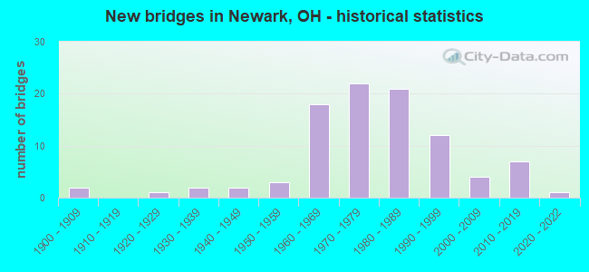
- New bridges - historical statistics
- 21900-1909
- 11920-1929
- 21930-1939
- 21940-1949
- 31950-1959
- 181960-1969
- 221970-1979
- 211980-1989
- 121990-1999
- 42000-2009
- 72010-2019
- 12020-2022
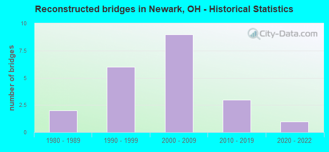
- Reconstructed bridges - Historical Statistics
- 21980-1989
- 61990-1999
- 92000-2009
- 32010-2019
- 12020-2022
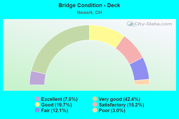
- Bridge Condition - Deck
- 7.6%Excellent
- 42.4%Very good
- 19.7%Good
- 15.2%Satisfactory
- 12.1%Fair
- 3.0%Poor
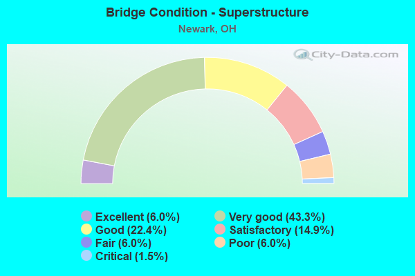
- Bridge Condition - Superstructure
- 6.0%Excellent
- 43.3%Very good
- 22.4%Good
- 14.9%Satisfactory
- 6.0%Fair
- 6.0%Poor
- 1.5%Critical
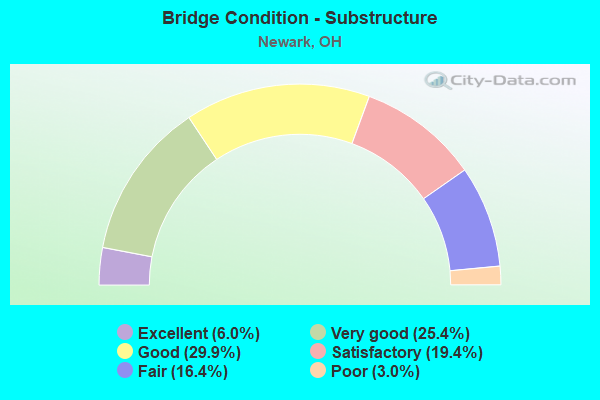
- Bridge Condition - Substructure
- 6.0%Excellent
- 25.4%Very good
- 29.9%Good
- 19.4%Satisfactory
- 16.4%Fair
- 3.0%Poor
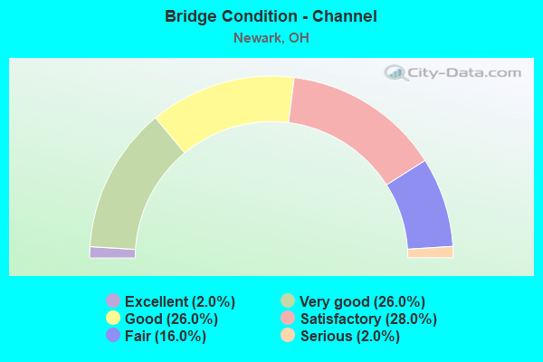
- Bridge Condition - Channel
- 2.0%Excellent
- 26.0%Very good
- 26.0%Good
- 28.0%Satisfactory
- 16.0%Fair
- 2.0%Serious
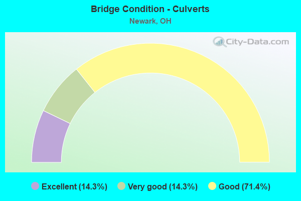
- Bridge Condition - Culverts
- 14.3%Excellent
- 14.3%Very good
- 71.4%Good
Find on map >> Show street view
Structure Number: 4500962, Location: .3 M E OF JCT SR13DA-NB (Lat: 40.061539, Lng: -82.398311), Route carried "under" structure: City street FRONT, Year Built: 1960, Structure Length: 0. m, Average Daily Traffic: 4,394 (year 2015), Truck Traffic: 5%, Features Intersected: FRONT ST UNDER SR16 & 79, Facility Carried by Structure: SR 16 & SR 79
Minimum Vertical Clearance: 5.69m (18.67ft), Kilometerpoint: 8.047, Lanes on structure: 4, Lanes under structure: 2, Material/Design: Steel continuous, Design/Construction: Stringer/Multi-beam, Length of Maximum Span: 16.8m (55.1ft)
Find on map >> Show street view
Structure Number: 450102, Location: .6 M E OF JCT SR13DA-NB (Lat: 40.061119, Lng: -82.393750), Route carried "under" structure: City street BUENA, Year Built: 1960, Structure Length: 0. m, Average Daily Traffic: 1,818 (year 2015), Truck Traffic: 1%, Features Intersected: BUENA VISTA UND SR16&79, Facility Carried by Structure: SR 16 & SR 79
Minimum Vertical Clearance: 4.47m (14.67ft), Kilometerpoint: 6.437, Lanes on structure: 4, Lanes under structure: 2, Material/Design: Concrete continuous, Design/Construction: Slab, Length of Maximum Span: 15.5m (50.9ft)
Find on map >> Show street view
Structure Number: 4501144, Location: 1 M E OF JCT SR13DA-NB (Lat: 40.061981, Lng: -82.386189), Route carried "under" structure: State highway 79, Year Built: 1965, Structure Length: 0. m, Average Daily Traffic: 9,404 (year 2015), Truck Traffic: 10%, Features Intersected: NB 79 & CEDAR ST UND 16, Facility Carried by Structure: STATE ROUTE 16
Minimum Vertical Clearance: 4.50m (14.76ft), Kilometerpoint: 25.041, Lanes on structure: 4, Lanes under structure: 4, Material/Design: Steel continuous, Design/Construction: Stringer/Multi-beam, Length of Maximum Span: 29.9m (98.1ft)
Find on map >> Show street view
Structure Number: 4501179, Location: .2 M E OF JCT SR 79 (Lat: 40.063189, Lng: -82.382050), Route carried "under" structure: City street OAKWD, Year Built: 1965, Structure Length: 0. m, Average Daily Traffic: 1,000 (year 1968), Features Intersected: OAKWOOD AVE UNDER SR16, Facility Carried by Structure: SR 16
Minimum Vertical Clearance: 4.57m (14.99ft), Kilometerpoint: 3.219, Lanes on structure: 4, Lanes under structure: 2, Material/Design: Concrete continuous, Design/Construction: Slab, Length of Maximum Span: 15.5m (50.9ft)
Find on map >> Show street view
Structure Number: 4501209, Location: .9 M E OF JCT SR 79 (Lat: 40.063461, Lng: -82.369989), Route carried "under" structure: City street OBANN, Year Built: 1965, Structure Length: 0. m, Average Daily Traffic: 4,394 (year 2015), Truck Traffic: 5%, Features Intersected: OBANNON AVE UNDER SR16, Facility Carried by Structure: SR 16
Minimum Vertical Clearance: 4.47m (14.67ft), Kilometerpoint: 1.609, Lanes on structure: 4, Lanes under structure: 2, Material/Design: Concrete continuous, Design/Construction: Slab, Length of Maximum Span: 15.5m (50.9ft)
Find on map >> Show street view
Structure Number: 4503031, Location: 1.7 M W OF JCT SR 79 (Lat: 40.058469, Lng: -82.448950), Route carried "under" structure: City street CTYCL, Year Built: 1972, Structure Length: 0. m, Average Daily Traffic: 8,120 (year 2015), Truck Traffic: 7%, Features Intersected: COUNTRY CLUB DRIVE UNDER, Facility Carried by Structure: SR 16
Minimum Vertical Clearance: 4.57m (14.99ft), Kilometerpoint: 6.437, Lanes on structure: 5, Lanes under structure: 3, Material/Design: Steel continuous, Design/Construction: Stringer/Multi-beam, Length of Maximum Span: 20.7m (67.9ft)
Find on map >> Show street view
Structure Number: 4503481, Location: .6 M W OF JCT SR 79 (Lat: 40.062869, Lng: -82.429569), Route carried "under" structure: City street 21, Year Built: 1972, Structure Length: 0. m, Average Daily Traffic: 19,887 (year 2015), Truck Traffic: 8%, Features Intersected: 21ST STREET UNDER SR16, Facility Carried by Structure: SR 16
Minimum Vertical Clearance: 4.65m (15.26ft), Kilometerpoint: 0.000, Lanes on structure: 4, Lanes under structure: 4, Material/Design: Steel continuous, Design/Construction: Stringer/Multi-beam, Length of Maximum Span: 24.7m (81.0ft)
Find on map >> Show street view
Structure Number: 450441, Location: .6 M W OF JCT SR 13 (Lat: 40.059531, Lng: -82.417531), Route carried "under" structure: City street N11TH, Year Built: 1972, Structure Length: 0. m, Average Daily Traffic: 7,128 (year 2015), Truck Traffic: 3%, Features Intersected: 11TH ST UNDER SR 16, Facility Carried by Structure: SR 16
Minimum Vertical Clearance: 4.65m (15.26ft), Lanes on structure: 4, Lanes under structure: 2, Material/Design: Concrete continuous, Design/Construction: Slab, Length of Maximum Span: 15.2m (49.9ft)
Find on map >> Show street view
Structure Number: 4504429, Location: NB 79 OVER 11TH ST (Lat: 40.059281, Lng: -82.417550), Route carried "under" structure: City street N11TH, Year Built: 1972, Structure Length: 0. m, Average Daily Traffic: 7,128 (year 2015), Truck Traffic: 3%, Features Intersected: 11TH ST UNDER NB SR 79, Facility Carried by Structure: NB SR 79 RDWY D
Minimum Vertical Clearance: 6.12m (20.08ft), Kilometerpoint: 0.933, Lanes on structure: 2, Lanes under structure: 2, Material/Design: Prestressed concrete, Design/Construction: Stringer/Multi-beam, Length of Maximum Span: 15.5m (50.9ft)
Find on map >> Show street view
Structure Number: 4504917, Location: 1.1 M S OF JCT SR 16 (Lat: 40.045139, Lng: -82.424931), Route carried "under" structure: State highway 79, Year Built: 1986, Structure Length: 0. m, Average Daily Traffic: 27,672 (year 2015), Truck Traffic: 8%, Features Intersected: SR79 UNDER HANCOCK ST, Facility Carried by Structure: HANCOCK STREET
Minimum Vertical Clearance: 4.75m (15.58ft), Kilometerpoint: 20.439, Lanes on structure: 2, Lanes under structure: 4, Material/Design: Prestressed concrete, Design/Construction: Box Beam or Girders - Multiple, Length of Maximum Span: 25.9m (85.0ft)
Find on map >> Show street view
Structure Number: 4504925, Location: 1 M S OF JCT SR 16 (Lat: 40.047050, Lng: -82.422789), Route carried "under" structure: State highway 79, Year Built: 1986, Structure Length: 0. m, Average Daily Traffic: 27,672 (year 2015), Truck Traffic: 7%, Features Intersected: SR 79 UNDER GRANT STREET, Facility Carried by Structure: GRANT STREET
Minimum Vertical Clearance: 5.82m (19.09ft), Kilometerpoint: 20.712, Lanes on structure: 2, Lanes under structure: 4, Material/Design: Prestressed concrete, Design/Construction: Box Beam or Girders - Multiple, Length of Maximum Span: 26.2m (86.0ft)
Find on map >> Show street view
Structure Number: 4504941, Location: .5 M S OF JCT SR 16 (Lat: 40.053439, Lng: -82.420950), Route carried "under" structure: State highway 79, Year Built: 1986, Structure Length: 0. m, Average Daily Traffic: 23,874 (year 2015), Truck Traffic: 6%, Features Intersected: SR 79 UNDER MAIN ST, Facility Carried by Structure: MAIN STREET
Minimum Vertical Clearance: 4.75m (15.58ft), Kilometerpoint: 21.420, Lanes on structure: 4, Lanes under structure: 4, Material/Design: Prestressed concrete, Design/Construction: Box Beam or Girders - Multiple, Length of Maximum Span: 23.8m (78.1ft)
Find on map >> Show street view
Structure Number: 4504976, Location: .2 M S OF JCT SR 16 (Lat: 40.057250, Lng: -82.420450), Route carried "under" structure: City street WCHUR, Year Built: 1987, Structure Length: 0. m, Average Daily Traffic: 8,120 (year 2015), Truck Traffic: 5%, Features Intersected: CHURCH ST UNDER SB SR 79, Facility Carried by Structure: SB SR 79
Minimum Vertical Clearance: 6.12m (20.08ft), Kilometerpoint: 0.145, Lanes on structure: 3, Lanes under structure: 2, Material/Design: Steel continuous, Design/Construction: Stringer/Multi-beam, Length of Maximum Span: 16.2m (53.1ft)
Find on map >> Show street view
Structure Number: 4504992, Location: .2 M S OF JCT SR 16 (Lat: 40.057239, Lng: -82.420050), Route carried "under" structure: City street WCHUR, Year Built: 1987, Structure Length: 0. m, Average Daily Traffic: 8,120 (year 2015), Truck Traffic: 5%, Features Intersected: CHURCH ST UNDER NB SR 79, Facility Carried by Structure: NB SR 79
Minimum Vertical Clearance: 4.50m (14.76ft), Kilometerpoint: 0.161, Lanes on structure: 3, Lanes under structure: 2, Material/Design: Steel continuous, Design/Construction: Stringer/Multi-beam, Length of Maximum Span: 16.8m (55.1ft)
Find on map >> Show street view
Structure Number: 4505026, Location: AT JCT OF SR 16 & RDWY A (Lat: 40.059419, Lng: -82.419550), Route carried "under" structure: State highway 16, Year Built: 1987, Structure Length: 0. m, Average Daily Traffic: 20,149 (year 2015), Truck Traffic: 3%, Features Intersected: SR16 & RDWY A UNDER SB79, Facility Carried by Structure: SB SR 79 (RDWY B)
Minimum Vertical Clearance: 5.11m (16.77ft), Kilometerpoint: 32.637, Lanes on structure: 2, Lanes under structure: 5, Material/Design: Steel continuous, Design/Construction: Stringer/Multi-beam, Length of Maximum Span: 24.7m (81.0ft)
Find on map >> Show street view
Structure Number: 450505, Location: SB SR 79 RDWY B OVER 11TH (Lat: 40.059950, Lng: -82.417481), Route carried "under" structure: City street N11TH, Year Built: 1987, Structure Length: 0. m, Average Daily Traffic: 7,128 (year 2015), Truck Traffic: 3%, Features Intersected: 11TH ST UNER SB SR 79, Facility Carried by Structure: SB SR 79 RDWY B
Minimum Vertical Clearance: 4.93m (16.17ft), Kilometerpoint: 0.966, Lanes on structure: 2, Lanes under structure: 2, Material/Design: Prestressed concrete, Design/Construction: Stringer/Multi-beam, Length of Maximum Span: 14.3m (46.9ft)