Bridge Statistics for New Rochelle, New York (NY)
Condition, Traffic, Stress, Structural Evaluation, Project Costs
- National Bridge Inventory (NBI) Statistics
- 59Number of bridges
- 456ft / 139mTotal length
- $281,602,000Total costs
- 1,206,426Total average daily traffic
- 70,632Total average daily truck traffic
- National Bridge Inventory (NBI) Registered Bridges for New Rochelle
- No street view available for this location
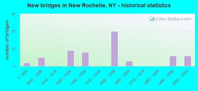
- New bridges - historical statistics
- 2Before 1900
- 51900-1909
- 91920-1929
- 81930-1939
- 201950-1959
- 31960-1969
- 61990-1999
- 62000-2009
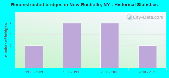
- Reconstructed bridges - Historical Statistics
- 21980-1989
- 41990-1999
- 42000-2009
- 22010-2019
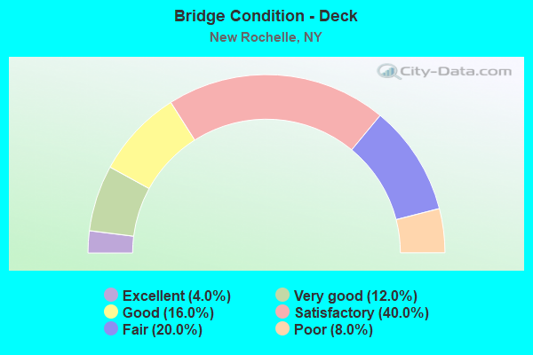
- Bridge Condition - Deck
- 4.0%Excellent
- 12.0%Very good
- 16.0%Good
- 40.0%Satisfactory
- 20.0%Fair
- 8.0%Poor
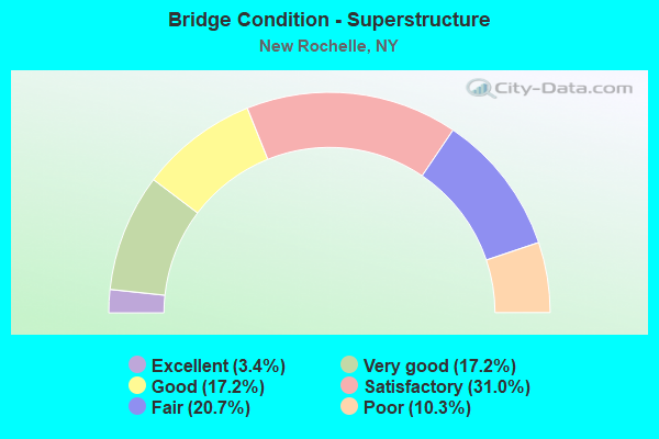
- Bridge Condition - Superstructure
- 3.4%Excellent
- 17.2%Very good
- 17.2%Good
- 31.0%Satisfactory
- 20.7%Fair
- 10.3%Poor
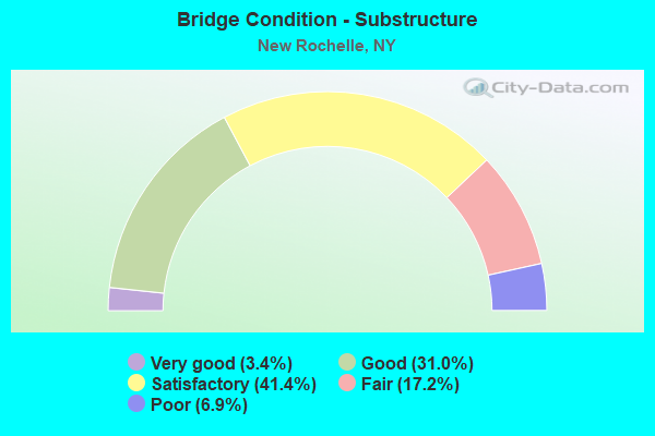
- Bridge Condition - Substructure
- 3.4%Very good
- 31.0%Good
- 41.4%Satisfactory
- 17.2%Fair
- 6.9%Poor
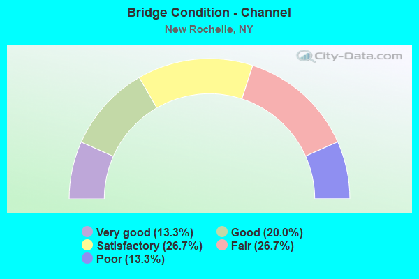
- Bridge Condition - Channel
- 13.3%Very good
- 20.0%Good
- 26.7%Satisfactory
- 26.7%Fair
- 13.3%Poor
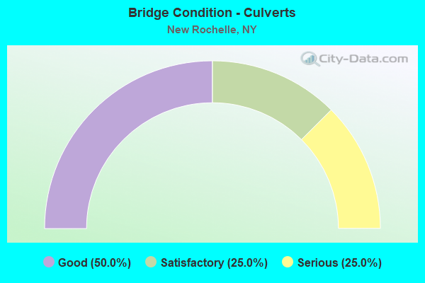
- Bridge Condition - Culverts
- 50.0%Good
- 25.0%Satisfactory
- 25.0%Serious
Find on map >> Show street view
Structure Number: 5514529, Location: 0.2 MI N JCT 95IX & US 1 (Lat: 40.902400, Lng: -73.794014), Route carried "under" structure: Other road , Year Built: 1954, Structure Length: 0. m, Average Daily Traffic: 11,529 (year 2019), Truck Traffic: 1%, Features Intersected: KINGS HIGHWAY, Facility Carried by Structure: RTE I95
Minimum Vertical Clearance: 4.72m (15.49ft), Kilometerpoint: 0.000, Lanes on structure: 7, Lanes under structure: 2, Material/Design: Concrete, Design/Construction: Frame, Length of Maximum Span: 21.6m (70.9ft)
Find on map >> Show street view
Structure Number: 5514539, Location: NEW ENGLAND VIADUCT (Lat: 40.906844, Lng: -73.790536), Route carried "under" structure: City street , Year Built: 1954, Structure Length: 0. m, Average Daily Traffic: 3,480 (year 2000), Truck Traffic: 4%, Features Intersected: WEBSTER AVENUE, METRO NO, Facility Carried by Structure: RTE I95
Minimum Vertical Clearance: 12.24m (40.16ft), Kilometerpoint: 0.274, Lanes on structure: 6, Lanes under structure: 2, Material/Design: Steel, Design/Construction: Stringer/Multi-beam, Length of Maximum Span: 40.5m (132.9ft)
Find on map >> Show street view
Structure Number: 551454, Location: 0.8 MI N JCT RTS I95&1 (Lat: 40.908856, Lng: -73.787000), Route carried "under" structure: Interstate 95, Year Built: 1954, Structure Length: 0. m, Average Daily Traffic: 107,202 (year 2014), Features Intersected: 95 IX Northbound, RTE I9, Facility Carried by Structure: CENTRE AVE
Minimum Vertical Clearance: 4.65m (15.26ft), Kilometerpoint: 8.673, Lanes on structure: 2, Lanes under structure: 3, Toll: On Interstate toll segment, Material/Design: Steel, Design/Construction: Stringer/Multi-beam, Length of Maximum Span: 21.9m (71.9ft)
Find on map >> Show street view
Structure Number: 551455, Location: 1.1 MI N JCT I95 & U.S.1 (Lat: 40.913550, Lng: -73.783819), Route carried "under" structure: Interstate 95, Year Built: 1954, Structure Length: 0. m, Average Daily Traffic: 28,800 (year 1974), Features Intersected: 95IX-SB, RTE I95, Facility Carried by Structure: North Avenue
Minimum Vertical Clearance: 4.72m (15.49ft), Kilometerpoint: 974.668, Lanes on structure: 4, Lanes under structure: 3, Toll: On Interstate toll segment, Material/Design: Steel, Design/Construction: Girder and Floorbeam System, Length of Maximum Span: 17.4m (57.1ft)
Find on map >> Show street view
Structure Number: 5514569, Location: 1.4 MI N JCT I95 & US 1 (Lat: 40.917178, Lng: -73.781192), Route carried "under" structure: Ramp Other road , Year Built: 1954, Structure Length: 0. m, Average Daily Traffic: 12,962 (year 2015), Features Intersected: CROSS COUNTY CONNECTION, Facility Carried by Structure: RTE I95
Minimum Vertical Clearance: 4.50m (14.76ft), Kilometerpoint: 0.000, Lanes on structure: 8, Lanes under structure: 3, Material/Design: Concrete, Design/Construction: Frame, Length of Maximum Span: 14.9m (48.9ft)
Find on map >> Show street view
Structure Number: 5514579, Location: 1.4 MI. N. JCT I95 & US-1 (Lat: 40.916439, Lng: -73.781875), Route carried "under" structure: City street , Year Built: 1958, Structure Length: 0. m, Average Daily Traffic: 7,500 (year 2021), Features Intersected: Cedar Street, Facility Carried by Structure: RTE I95
Minimum Vertical Clearance: 4.47m (14.67ft), Kilometerpoint: 0.000, Lanes on structure: 8, Lanes under structure: 2, Material/Design: Concrete, Design/Construction: Frame, Length of Maximum Span: 15.2m (49.9ft)
Find on map >> Show street view
Structure Number: 5514589, Location: 2.1 MI N JCT I95 & US 1 (Lat: 40.924556, Lng: -73.772131), Route carried "under" structure: Interstate , Year Built: 2002, Structure Length: 0. m, Average Daily Traffic: 95,350 (year 2000), Features Intersected: 95IX, 95IX, MNRR NH LINE, Facility Carried by Structure: RTE 982
Minimum Vertical Clearance: 7.16m (23.49ft), Kilometerpoint: 10.845, Lanes on structure: 4, Lanes under structure: 3, Toll: On Interstate toll segment, Material/Design: Steel continuous, Design/Construction: Stringer/Multi-beam, Length of Maximum Span: 45.4m (149.0ft)
Find on map >> Show street view
Structure Number: 552488, Location: 100 ft. SW of North Ave (Lat: 40.913222, Lng: -73.783897), Route carried "under" structure: Interstate , Year Built: 2009, Structure Length: 0. m, Features Intersected: 95IX NB, 95IX, Facility Carried by Structure: North Avenue Utili
Minimum Vertical Clearance: 5.59m (18.34ft), Kilometerpoint: 974.603, Lanes under structure: 3, Toll: On Interstate toll segment, Material/Design: Steel, Design/Construction: Truss - Thru, Length of Maximum Span: 33.5m (109.9ft)
Find on map >> Show street view
Structure Number: 700003, Location: JCT RR&RTE 1 NEW ROCHELLE (Lat: 40.900847, Lng: -73.794169), Route carried "under" structure: US 1, Year Built: 1935, Structure Length: 0. m, Average Daily Traffic: 18,396 (year 1998), Features Intersected: RTE 1, Facility Carried by Structure: AMTRAK
Minimum Vertical Clearance: 4.41m (14.47ft), Kilometerpoint: 0.499, Lanes under structure: 3, Material/Design: Steel, Design/Construction: Girder and Floorbeam System, Length of Maximum Span: 16.7m (54.8ft)
Find on map >> Show street view
Structure Number: 7700561, Location: 1.3 MI NE OF PELHAM MANOR (Lat: 40.906558, Lng: -73.790033), Route carried "under" structure: City street , Year Built: 1907, Structure Length: 0. m, Average Daily Traffic: 4,459 (year 2019), Truck Traffic: 4%, Features Intersected: WEBSTER AVENUE, Facility Carried by Structure: AMTRAK
Minimum Vertical Clearance: 4.26m (13.98ft), Kilometerpoint: 0.000, Lanes under structure: 2, Material/Design: Steel, Design/Construction: Girder and Floorbeam System, Length of Maximum Span: 16.7m (54.8ft)
Find on map >> Show street view
Structure Number: 7700562, Location: 1.3 MI NE OF PELHAM MANOR (Lat: 40.906622, Lng: -73.790144), Route carried "under" structure: City street , Year Built: 1907, Structure Length: 0. m, Average Daily Traffic: 10,506 (year 2010), Truck Traffic: 5%, Features Intersected: WEBSTER AVENUE, Facility Carried by Structure: AMTRAK
Minimum Vertical Clearance: 3.45m (11.32ft), Kilometerpoint: 0.000, Lanes under structure: 2, Material/Design: Steel, Design/Construction: Girder and Floorbeam System, Length of Maximum Span: 23.1m (75.8ft)
Find on map >> Show street view
Structure Number: 770057, Location: 1.2 MI NE OF PELHAM MANOR (Lat: 40.905478, Lng: -73.791033), Route carried "under" structure: City street , Year Built: 1906, Structure Length: 0. m, Truck Traffic: 4%, Features Intersected: BEECHWOOD AVENUE, Facility Carried by Structure: AMTRAK
Minimum Vertical Clearance: 4.67m (15.32ft), Kilometerpoint: 0.000, Lanes under structure: 2, Material/Design: Steel, Design/Construction: Girder and Floorbeam System, Length of Maximum Span: 10.0m (32.8ft)
Find on map >> Show street view
Structure Number: 7700581, Location: 1.0 MI NE OF PELHAM MANOR (Lat: 40.902228, Lng: -73.793128), Route carried "under" structure: City street , Year Built: 1920, Structure Length: 0. m, Average Daily Traffic: 5,765 (year 2019), Truck Traffic: 1%, Features Intersected: KINGS HIGHWAY, Facility Carried by Structure: AMTRAK
Minimum Vertical Clearance: 3.40m (11.15ft), Kilometerpoint: 0.515, Lanes under structure: 2, Material/Design: Steel, Design/Construction: Girder and Floorbeam System, Length of Maximum Span: 16.7m (54.8ft)
Find on map >> Show street view
Structure Number: 7700582, Location: 1.0 MI NE OF PELHAM MANOR (Lat: 40.902247, Lng: -73.793225), Route carried "under" structure: City street , Year Built: 1920, Structure Length: 0. m, Average Daily Traffic: 13,020 (year 2010), Truck Traffic: 1%, Features Intersected: KINGS HIGHWAY, Facility Carried by Structure: AMTRAK
Minimum Vertical Clearance: 3.40m (11.15ft), Kilometerpoint: 0.515, Lanes under structure: 2, Material/Design: Steel, Design/Construction: Girder and Floorbeam System, Length of Maximum Span: 17.9m (58.7ft)
Find on map >> Show street view
Structure Number: 771258, Location: 0.7 MI E OF PELHAM (Lat: 40.906981, Lng: -73.793572), Route carried "under" structure: City street , Year Built: 1894, Structure Length: 0. m, Features Intersected: SECOND STREET, Facility Carried by Structure: MNRR NH LINE
Minimum Vertical Clearance: 3.65m (11.98ft), Kilometerpoint: 0.000, Lanes under structure: 2, Material/Design: Masonry, Design/Construction: Arch - Deck, Length of Maximum Span: 13.7m (44.9ft)
Find on map >> Show street view
Structure Number: 771281, Location: 0.8 MI E OF PELHAM (Lat: 40.907197, Lng: -73.790900), Route carried "under" structure: City street , Year Built: 1904, Structure Length: 0. m, Average Daily Traffic: 8,917 (year 2019), Truck Traffic: 4%, Features Intersected: WEBSTER AVENUE, Facility Carried by Structure: MNRR NH LINE
Minimum Vertical Clearance: 3.45m (11.32ft), Kilometerpoint: 0.322, Lanes under structure: 2, Material/Design: Steel, Design/Construction: Girder and Floorbeam System, Length of Maximum Span: 16.7m (54.8ft)