Bridge Statistics for New Rochelle, New York (NY)
Condition, Traffic, Stress, Structural Evaluation, Project Costs
- National Bridge Inventory (NBI) Statistics
- 59Number of bridges
- 456ft / 139mTotal length
- $281,602,000Total costs
- 1,206,426Total average daily traffic
- 70,632Total average daily truck traffic
- National Bridge Inventory (NBI) Registered Bridges for New Rochelle
- No street view available for this location
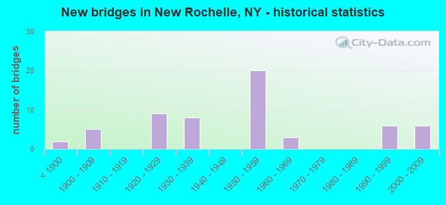
- New bridges - historical statistics
- 2Before 1900
- 51900-1909
- 91920-1929
- 81930-1939
- 201950-1959
- 31960-1969
- 61990-1999
- 62000-2009
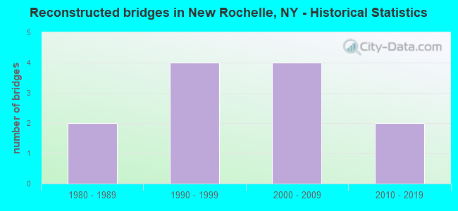
- Reconstructed bridges - Historical Statistics
- 21980-1989
- 41990-1999
- 42000-2009
- 22010-2019
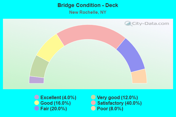
- Bridge Condition - Deck
- 4.0%Excellent
- 12.0%Very good
- 16.0%Good
- 40.0%Satisfactory
- 20.0%Fair
- 8.0%Poor
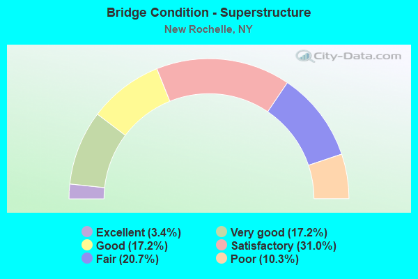
- Bridge Condition - Superstructure
- 3.4%Excellent
- 17.2%Very good
- 17.2%Good
- 31.0%Satisfactory
- 20.7%Fair
- 10.3%Poor
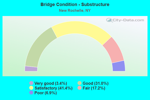
- Bridge Condition - Substructure
- 3.4%Very good
- 31.0%Good
- 41.4%Satisfactory
- 17.2%Fair
- 6.9%Poor
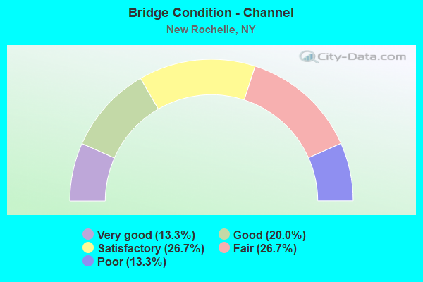
- Bridge Condition - Channel
- 13.3%Very good
- 20.0%Good
- 26.7%Satisfactory
- 26.7%Fair
- 13.3%Poor
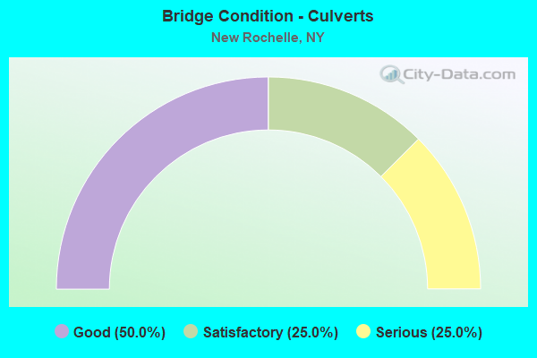
- Bridge Condition - Culverts
- 50.0%Good
- 25.0%Satisfactory
- 25.0%Serious
Find on map >> Show street view
Structure Number: 103752, Location: JCT RTE 125+HRP (Lat: 40.969314, Lng: -73.774103), Route carried "on" structure: State highway 125, Year Built: 1926, Year Reconstructed: 2001, Status: Open, Structure Length: 1.77m (5.81ft), Average Daily Traffic: 11,918 (year 2020), Truck Traffic: 3%, Average Future Daily Traffic: 11,974 (year 2040), Design Load: H 20, Features Intersected: 907W 907W87011067 SB, RT
Minimum Vertical Clearance: 30+ m (98+ ft), Kilometerpoint: 4.779, Lanes on structure: 3, Lanes under structure: 4, Base Highway Network: Yes, Owner: State Highway Agency, Approaching Roadway Width: 7.3m (24.0ft), Material/Design: Concrete, Design/Construction: Frame, Number Of Spans In Main Unit: 1, Length of Maximum Span: 17.0m (55.8ft), Curb or Sidewalk Widths: Left: 2.1m (6.9ft), Right: 1.8m (5.9ft), Curb-To-Curb Width: 10.8m (35.4ft), Out-to-Out Width: 15.5m (50.9ft)
Condition: Deck: Fair, Superstructure: Fair, Substructure: Good, Operating Rating: 55.1 metric tons, Method Used To Determine Operating Rating: Field evaluation and documented engineering judgment, Inventory Rating: 20.1 metric tons, Method Used To Determine Inventory Rating: Field evaluation and documented engineering judgment, Structural Evaluation: Somewhat better than minimum adequacy, Deck Geometry: High priority of replacement, Underclear: High priority of corrective action, Approach Roadway Alignment: Meets minimum limits, Length Of Structure Improvement: 1.76m (5.77ft), Designated Inspection Frequency: Every 24 months, Inspection Date: August 2021, Bridge Improvement Cost: $1,530,000, Roadway Improvement Cost: $896,000, Total Project Cost: $2,425,000 ( Estimate for 2021)
Find on map >> Show street view
Structure Number: 1049889, Location: 0.5MI N JCT RTE1+NORTH AV (Lat: 40.916000, Lng: -73.784989), Route carried "on" structure: State highway 981U, Year Built: 1965, Year Reconstructed: 2002, Status: Open, Structure Length: 2.68m (8.79ft), Average Daily Traffic: 15,649 (year 2020), Truck Traffic: 4%, Average Future Daily Traffic: 19,362 (year 2040), Design Load: HS 25 or greater, Features Intersected: NORTH AVE - CR 81
Minimum Vertical Clearance: 30+ m (98+ ft), Kilometerpoint: 0.193, Lanes on structure: 4, Lanes under structure: 4, Base Highway Network: Yes, Owner: State Highway Agency, Approaching Roadway Width: 15.2m (49.9ft), Skew: 30 degrees, Material/Design: Steel, Design/Construction: Stringer/Multi-beam, Number Of Spans In Main Unit: 1, Length of Maximum Span: 25.2m (82.7ft), Curb or Sidewalk Widths: Left: 2.0m (6.6ft), Right: 2.0m (6.6ft), Curb-To-Curb Width: 15.2m (49.9ft), Out-to-Out Width: 21.4m (70.2ft)
Condition: Deck: Satisfactory, Superstructure: Satisfactory, Substructure: Fair, Operating Rating: 72.3 metric tons, Method Used To Determine Operating Rating: Load Factor (LF), Inventory Rating: 43.3 metric tons, Method Used To Determine Inventory Rating: Load Factor (LF), Structural Evaluation: Somewhat better than minimum adequacy, Deck Geometry: High priority of corrective action, Underclear: High priority of corrective action, Approach Roadway Alignment: Equal to present desirable criteria, Length Of Structure Improvement: 2.68m (8.79ft), Designated Inspection Frequency: Every 24 months, Inspection Date: July 2020, Bridge Improvement Cost: $4,394,000, Roadway Improvement Cost: $2,573,000, Total Project Cost: $6,968,000 ( Estimate for 2021), Deck Structure Type: Concrete Cast-file-Place, Wearing Surface/Protective System: Wearing Surface: Integral Concrete, Deck Protection: Epoxy Coated Reinforcing
Find on map >> Show street view
Structure Number: 104989, Location: IN NEW ROCHELLE (Lat: 40.910161, Lng: -73.784956), Route carried "on" structure: State highway , Year Built: 1929, Year Reconstructed: 2008, Status: Open, Structure Length: 1.77m (5.81ft), Average Daily Traffic: 6,460 (year 2016), Truck Traffic: 4%, Average Future Daily Traffic: 7,992 (year 2040), Features Intersected: MNRR NH LINE, Facility Carried by Structure: DIVISION STREET
Minimum Vertical Clearance: 30+ m (98+ ft), Kilometerpoint: 0.676, Lanes on structure: 3, Owner: State Highway Agency, Approaching Roadway Width: 12.2m (40.0ft), Skew: 1 degrees, Material/Design: Steel, Design/Construction: Stringer/Multi-beam, Number Of Spans In Main Unit: 1, Length of Maximum Span: 17.4m (57.1ft), Curb or Sidewalk Widths: Left: 1.5m (4.9ft), Right: 1.8m (5.9ft), Curb-To-Curb Width: 11.8m (38.7ft), Out-to-Out Width: 17.0m (55.8ft)
Condition: Deck: Excellent, Superstructure: Excellent, Substructure: Very good, Channel: Very good, Inventory Rating: 65.3 metric tons, Method Used To Determine Inventory Rating: Load Factor (LF), Structural Evaluation: Equal to present desirable criteria, Deck Geometry: High priority of corrective action, Underclear: High priority of corrective action, Approach Roadway Alignment: Meets minimum limits, Length Of Structure Improvement: 1.76m (5.77ft), Designated Inspection Frequency: Every 24 months, Inspection Date: December 2021, Bridge Improvement Cost: $2,568,000, Roadway Improvement Cost: $1,504,000, Total Project Cost: $4,072,000 ( Estimate for 2021), Deck Structure Type: Concrete Cast-file-Place, Wearing Surface/Protective System: Wearing Surface: Integral Concrete, Deck Protection: Epoxy Coated Reinforcing
Find on map >> Show street view
Structure Number: 107361, Location: .1M W.JCT RT 125 & HRP (Lat: 40.969339, Lng: -73.776725), Route carried "on" structure: Ramp Other road , Year Built: 1990, Year Reconstructed: 2005, Status: Open, Structure Length: 0.82m (2.69ft), Truck Traffic: 3%, Design Load: HS 20, Features Intersected: SHELDRAKE RIVER, Facility Carried by Structure: RAMP TO HRP SB
Minimum Vertical Clearance: 30+ m (98+ ft), Kilometerpoint: 0.016, Lanes on structure: 1, Owner: State Highway Agency, Approaching Roadway Width: 6.7m (22.0ft), Material/Design: Concrete, Design/Construction: Culvert, Number Of Spans In Main Unit: 2, Length of Maximum Span: 3.6m (11.8ft), Curb-To-Curb Width: 6.8m (22.3ft), Out-to-Out Width: 11.3m (37.1ft)
Condition: Channel: Good, Culverts: Satisfactory, Operating Rating: 66.1 metric tons, Method Used To Determine Operating Rating: Load and Resistance Factor Rating (LRFR) rating reported by rating factor(RF) method using HL-93 loadings, Inventory Rating: 50.9 metric tons, Method Used To Determine Inventory Rating: Load and Resistance Factor Rating (LRFR) rating reported by rating factor(RF) method using HL-93 loadings, Structural Evaluation: Equal to present minimum criteria, Deck Geometry: Equal to present minimum criteria, Waterway Adequacy: High priority of corrective action, Approach Roadway Alignment: Equal to present desirable criteria, Length Of Structure Improvement: 0.82m (2.69ft), Designated Inspection Frequency: Every 24 months, Inspection Date: April 2020, Bridge Improvement Cost: $262,000, Roadway Improvement Cost: $153,000, Total Project Cost: $415,000 ( Estimate for 2021), Wearing Surface/Protective System: Wearing Surface: Monolithic Concrete
Find on map >> Show street view
Structure Number: 109138, Location: .1MI N US1&.2 MI S NOR ST (Lat: 40.911208, Lng: -73.784989), Route carried "on" structure: State highway 981, Year Built: 2009, Status: Open, Structure Length: 12.01m (39.40ft), Average Daily Traffic: 12,677 (year 2020), Truck Traffic: 4%, Average Future Daily Traffic: 15,685 (year 2040), Design Load: HS 25 or greater, Features Intersected: 95IX SB, 95IX, Station P
Minimum Vertical Clearance: 30+ m (98+ ft), Kilometerpoint: 0.290, Lanes on structure: 3, Lanes under structure: 8, Base Highway Network: Yes, Owner: State Highway Agency, Approaching Roadway Width: 11.0m (36.1ft), Skew: 2 degrees, Material/Design: Steel continuous, Design/Construction: Stringer/Multi-beam, Number Of Spans In Main Unit: 5, Length of Maximum Span: 29.9m (98.1ft), Curb or Sidewalk Widths: Left: 1.7m (5.6ft), Right: 2.7m (8.9ft), Curb-To-Curb Width: 11.2m (36.7ft), Out-to-Out Width: 16.3m (53.5ft)
Condition: Deck: Good, Superstructure: Very good, Substructure: Good, Operating Rating: 83.6 metric tons, Method Used To Determine Operating Rating: Field evaluation and documented engineering judgment, Inventory Rating: 40.8 metric tons, Method Used To Determine Inventory Rating: Field evaluation and documented engineering judgment, Structural Evaluation: Better than present minimum criteria, Deck Geometry: High priority of replacement, Underclear: Equal to present minimum criteria, Approach Roadway Alignment: Meets minimum limits, Length Of Structure Improvement: 12.00m (39.37ft), Designated Inspection Frequency: Every 24 months, Inspection Date: December 2021, Bridge Improvement Cost: $8,803,000, Roadway Improvement Cost: $5,155,000, Total Project Cost: $13,958,000 ( Estimate for 2021), Deck Structure Type: Concrete Cast-file-Place, Wearing Surface/Protective System: Wearing Surface: Integral Concrete, Deck Protection: Epoxy Coated Reinforcing
Find on map >> Show street view
Structure Number: 109139, Location: JCT RTE I95+0.1MI N RTE 1 (Lat: 40.910450, Lng: -73.785322), Route carried "on" structure: City street 981V, Year Built: 2008, Status: Open, Structure Length: 5.00m (16.40ft), Average Daily Traffic: 6,460 (year 2016), Truck Traffic: 4%, Average Future Daily Traffic: 7,992 (year 2040), Design Load: HS 20, Features Intersected: 95IX - NB, RTE I95
Minimum Vertical Clearance: 30+ m (98+ ft), Kilometerpoint: 0.708, Lanes on structure: 3, Lanes under structure: 7, Owner: State Highway Agency, Approaching Roadway Width: 11.0m (36.1ft), Skew: 3 degrees, Material/Design: Steel continuous, Design/Construction: Stringer/Multi-beam, Number Of Spans In Main Unit: 2, Length of Maximum Span: 29.3m (96.1ft), Curb or Sidewalk Widths: Left: 1.4m (4.6ft), Right: 1.6m (5.2ft), Curb-To-Curb Width: 11.4m (37.4ft), Out-to-Out Width: 16.4m (53.8ft)
Condition: Deck: Very good, Superstructure: Very good, Substructure: Good, Operating Rating: 85.8 metric tons, Method Used To Determine Operating Rating: Field evaluation and documented engineering judgment, Inventory Rating: 32.7 metric tons, Method Used To Determine Inventory Rating: Field evaluation and documented engineering judgment, Structural Evaluation: Better than present minimum criteria, Deck Geometry: High priority of replacement, Underclear: High priority of corrective action, Approach Roadway Alignment: Meets minimum limits, Length Of Structure Improvement: 4.99m (16.37ft), Designated Inspection Frequency: Every 24 months, Inspection Date: December 2021, Bridge Improvement Cost: $5,039,000, Roadway Improvement Cost: $2,951,000, Total Project Cost: $7,990,000 ( Estimate for 2021), Deck Structure Type: Concrete Cast-file-Place, Wearing Surface/Protective System: Wearing Surface: Integral Concrete
Find on map >> Show street view
Structure Number: 10914, Location: JCT RTE I95+0.2MI N RTE 1 (Lat: 40.911539, Lng: -73.785567), Route carried "on" structure: Ramp City street , Year Built: 1955, Year Reconstructed: 2009, Status: Open, Structure Length: 1.40m (4.59ft), Truck Traffic: 10%, Design Load: HS 20, Features Intersected: RAMP TO 95IX, Facility Carried by Structure: CONNECTOR
Minimum Vertical Clearance: 30+ m (98+ ft), Kilometerpoint: 0.016, Lanes on structure: 1, Lanes under structure: 1, Owner: State Highway Agency, Approaching Roadway Width: 9.8m (32.2ft), Material/Design: Concrete, Design/Construction: Frame, Number Of Spans In Main Unit: 1, Length of Maximum Span: 12.1m (39.7ft), Curb or Sidewalk Widths: Left: 0.0m, Right: 1.7m (5.6ft), Curb-To-Curb Width: 9.8m (32.2ft), Out-to-Out Width: 12.2m (40.0ft)
Condition: Deck: Satisfactory, Superstructure: Satisfactory, Substructure: Satisfactory, Operating Rating: 80.4 metric tons, Method Used To Determine Operating Rating: Field evaluation and documented engineering judgment, Inventory Rating: 29.4 metric tons, Method Used To Determine Inventory Rating: Field evaluation and documented engineering judgment, Structural Evaluation: Equal to present minimum criteria, Deck Geometry: Superior to present desirable criteria, Underclear: High priority of corrective action, Approach Roadway Alignment: Meets minimum limits, Length Of Structure Improvement: 1.40m (4.59ft), Designated Inspection Frequency: Every 24 months, Inspection Date: July 2021, Bridge Improvement Cost: $1,068,000, Roadway Improvement Cost: $625,000, Total Project Cost: $1,693,000 ( Estimate for 2021)
Find on map >> Show street view
Structure Number: 222513, Location: 1.3 MI W OF MAMARONECK (Lat: 40.947186, Lng: -73.762675), Route carried "on" structure: Other road , Year Built: 1930, Status: Open, Structure Length: 0.73m (2.40ft), Average Daily Traffic: 2,299 (year 2018), Truck Traffic: 3%, Average Future Daily Traffic: 2,844 (year 2040), Features Intersected: SHELDRAKE RIVER, Facility Carried by Structure: ROCKLAND AVENUE
Minimum Vertical Clearance: 30+ m (98+ ft), Kilometerpoint: 1.319, Lanes on structure: 2, Owner: Town or Township Highway Agency, Maintenance Responsibility: County Highway Agency, Approaching Roadway Width: 9.1m (29.9ft), Skew: 1 degrees, Material/Design: Concrete, Design/Construction: Slab, Number Of Spans In Main Unit: 1, Length of Maximum Span: 6.0m (19.7ft), Curb-To-Curb Width: 9.2m (30.2ft), Out-to-Out Width: 14.4m (47.2ft)
Condition: Deck: Poor, Superstructure: Fair, Substructure: Fair, Channel: Fair, Operating Rating: 62.6 metric tons, Method Used To Determine Operating Rating: Load Factor (LF), Inventory Rating: 37.2 metric tons, Method Used To Determine Inventory Rating: Load Factor (LF), Structural Evaluation: Somewhat better than minimum adequacy, Deck Geometry: Meets minimum limits, Waterway Adequacy: Meets minimum limits, Approach Roadway Alignment: Equal to present desirable criteria, Length Of Structure Improvement: 0.73m (2.40ft), Designated Inspection Frequency: Every 24 months, Inspection Date: March 2020, Bridge Improvement Cost: $387,000, Roadway Improvement Cost: $226,000, Total Project Cost: $613,000 ( Estimate for 2021), Wearing Surface/Protective System: Wearing Surface: Bituminous
Find on map >> Show street view
Structure Number: 226226, Location: 1.5 MI NE OF PELHAM MANOR (Lat: 40.908717, Lng: -73.786483), Route carried "on" structure: City street , Year Built: 1886, Year Reconstructed: 1992, Status: Posted for load, Structure Length: 2.16m (7.09ft), Average Daily Traffic: 4,446 (year 2017), Truck Traffic: 4%, Average Future Daily Traffic: 6,224 (year 2037), Design Load: HS 20, Features Intersected: MNRR NH LINE, Facility Carried by Structure: CENTRE AVENUE
Minimum Vertical Clearance: 30+ m (98+ ft), Kilometerpoint: 1.175, Lanes on structure: 2, Owner: Railroad, Maintenance Responsibility: City or Municipal Highway Agency, Approaching Roadway Width: 7.6m (24.9ft), Skew: 2 degrees, Material/Design: Steel, Design/Construction: Truss - Thru, Number Of Spans In Main Unit: 1, Length of Maximum Span: 19.8m (65.0ft), Curb or Sidewalk Widths: Left: 2.8m (9.2ft), Right: 2.8m (9.2ft), Curb-To-Curb Width: 7.8m (25.6ft), Out-to-Out Width: 15.1m (49.5ft)
Condition: Deck: Fair, Superstructure: Poor, Substructure: Fair, Operating Rating: 2.7 metric tons, Method Used To Determine Operating Rating: Field evaluation and documented engineering judgment, Inventory Rating: 2.7 metric tons, Method Used To Determine Inventory Rating: Field evaluation and documented engineering judgment, Structural Evaluation: High priority of corrective action, Deck Geometry: High priority of replacement, Underclear: High priority of corrective action, Approach Roadway Alignment: Equal to present minimum criteria, Bridge Posting: Required (Relationship of Operating Rating to Maximum Legal Load: > 39.9% below), Length Of Structure Improvement: 2.16m (7.09ft), Designated Inspection Frequency: Every 12 months, Critical Feature Inspection Frequency: Every 12 months, Inspection Date: December 2021, Critical Feature Inspection Date: December 2021, Bridge Improvement Cost: $4,851,000, Roadway Improvement Cost: $2,841,000, Total Project Cost: $7,692,000 ( Estimate for 2021), Deck Structure Type: Closed Grating, Wearing Surface/Protective System: Wearing Surface: Bituminous
Find on map >> Show street view
Structure Number: 226229, Location: 1.4 MI W OF MAMARONECK (Lat: 40.948792, Lng: -73.764181), Route carried "on" structure: Other road , Year Built: 1950, Year Reconstructed: 2003, Status: Open, Structure Length: 0.91m (2.99ft), Average Daily Traffic: 197 (year 2019), Truck Traffic: 4%, Average Future Daily Traffic: 276 (year 2039), Features Intersected: SHELDRAKE RIVER, Facility Carried by Structure: BONNIE BRIAR LANE
Minimum Vertical Clearance: 30+ m (98+ ft), Kilometerpoint: 0.097, Lanes on structure: 2, Owner: Town or Township Highway Agency, Approaching Roadway Width: 10.1m (33.1ft), Skew: 4 degrees, Material/Design: Steel, Design/Construction: Stringer/Multi-beam, Number Of Spans In Main Unit: 1, Length of Maximum Span: 7.9m (25.9ft), Curb or Sidewalk Widths: Left: 0.3m (1.0ft), Right: 2.6m (8.5ft), Curb-To-Curb Width: 10.2m (33.5ft), Out-to-Out Width: 13.7m (44.9ft)
Condition: Deck: Satisfactory, Superstructure: Fair, Substructure: Satisfactory, Channel: Poor, Operating Rating: 45.0 metric tons, Method Used To Determine Operating Rating: Load and Resistance Factor Rating (LRFR) rating reported by rating factor(RF) method using HL-93 loadings, Inventory Rating: 35.0 metric tons, Method Used To Determine Inventory Rating: Load and Resistance Factor Rating (LRFR) rating reported by rating factor(RF) method using HL-93 loadings, Structural Evaluation: Somewhat better than minimum adequacy, Deck Geometry: Better than present minimum criteria, Waterway Adequacy: Meets minimum limits, Approach Roadway Alignment: Equal to present desirable criteria, Length Of Structure Improvement: 0.91m (2.99ft), Designated Inspection Frequency: Every 24 months, Inspection Date: March 2021, Bridge Improvement Cost: $1,032,000, Roadway Improvement Cost: $604,000, Total Project Cost: $1,637,000 ( Estimate for 2021), Deck Structure Type: Concrete Cast-file-Place, Wearing Surface/Protective System: Wearing Surface: Bituminous
Find on map >> Show street view
Structure Number: 226518, Location: 0.3 MI N SHELDRAKE LAKE (Lat: 40.957908, Lng: -73.776497), Route carried "on" structure: Ramp Other road , Year Built: 1936, Status: Open, Structure Length: 0.73m (2.40ft), Average Daily Traffic: 8,655 (year 2016), Truck Traffic: 2%, Average Future Daily Traffic: 10,514 (year 2040), Features Intersected: SHELDRAKE RIVER, Facility Carried by Structure: PINE-QUAKER RAMP
Minimum Vertical Clearance: 30+ m (98+ ft), Kilometerpoint: 1.947, Lanes on structure: 2, Owner: City or Municipal Highway Agency, Approaching Roadway Width: 6.7m (22.0ft), Skew: 1 degrees, Material/Design: Concrete, Design/Construction: Frame, Number Of Spans In Main Unit: 1, Length of Maximum Span: 6.4m (21.0ft), Curb-To-Curb Width: 6.6m (21.7ft), Out-to-Out Width: 9.0m (29.5ft)
Condition: Deck: Fair, Superstructure: Fair, Substructure: Satisfactory, Channel: Fair, Operating Rating: 74.4 metric tons, Method Used To Determine Operating Rating: Allowable Stress (AS), Inventory Rating: 45.4 metric tons, Method Used To Determine Inventory Rating: Allowable Stress (AS), Structural Evaluation: Somewhat better than minimum adequacy, Deck Geometry: High priority of replacement, Waterway Adequacy: Superior to present desirable criteria, Approach Roadway Alignment: Meets minimum limits, Length Of Structure Improvement: 0.73m (2.40ft), Designated Inspection Frequency: Every 24 months, Inspection Date: March 2021, Bridge Improvement Cost: $314,000, Roadway Improvement Cost: $184,000, Total Project Cost: $498,000 ( Estimate for 2021), Wearing Surface/Protective System: Wearing Surface: Monolithic Concrete
Find on map >> Show street view
Structure Number: 226547, Location: W END SHELDRAKE LAKE (Lat: 40.954053, Lng: -73.776847), Route carried "on" structure: City street , Year Built: 1935, Status: Open, Structure Length: 0.94m (3.08ft), Average Daily Traffic: 8,498 (year 2018), Truck Traffic: 3%, Average Future Daily Traffic: 10,323 (year 2040), Features Intersected: SHELDRAKE RIVER, Facility Carried by Structure: PINE BROOK BLVD.
Minimum Vertical Clearance: 30+ m (98+ ft), Kilometerpoint: 2.478, Lanes on structure: 1, Owner: City or Municipal Highway Agency, Approaching Roadway Width: 6.1m (20.0ft), Material/Design: Concrete, Design/Construction: Arch - Deck, Number Of Spans In Main Unit: 1, Length of Maximum Span: 7.6m (24.9ft), Curb or Sidewalk Widths: Left: 0.0m, Right: 2.0m (6.6ft), Curb-To-Curb Width: 8.4m (27.6ft), Out-to-Out Width: 9.4m (30.8ft)
Condition: Superstructure: Satisfactory, Substructure: Satisfactory, Channel: Fair, Operating Rating: 70.5 metric tons, Method Used To Determine Operating Rating: Field evaluation and documented engineering judgment, Inventory Rating: 18.9 metric tons, Method Used To Determine Inventory Rating: Field evaluation and documented engineering judgment, Structural Evaluation: Meets minimum limits, Deck Geometry: High priority of replacement, Waterway Adequacy: Meets minimum limits, Approach Roadway Alignment: Meets minimum limits, Length Of Structure Improvement: 0.94m (3.08ft), Designated Inspection Frequency: Every 24 months, Inspection Date: April 2021, Bridge Improvement Cost: $1,400,000, Roadway Improvement Cost: $820,000, Total Project Cost: $2,220,000 ( Estimate for 2021)
Find on map >> Show street view
Structure Number: 226583, Location: 2.7 MI NE OF TUCKAHOE. (Lat: 40.973342, Lng: -73.778058), Route carried "on" structure: City street , Year Built: 1965, Status: Open, Structure Length: 0.70m (2.30ft), Average Daily Traffic: 493 (year 2017), Truck Traffic: 4%, Average Future Daily Traffic: 690 (year 2037), Features Intersected: CARPENTER CREEK, Facility Carried by Structure: HARLAN DRIVE
Minimum Vertical Clearance: 30+ m (98+ ft), Kilometerpoint: 0.032, Lanes on structure: 2, Owner: City or Municipal Highway Agency, Approaching Roadway Width: 9.1m (29.9ft), Skew: 1 degrees, Material/Design: Steel, Design/Construction: Culvert, Number Of Spans In Main Unit: 3, Length of Maximum Span: 1.8m (5.9ft)
Condition: Channel: Poor, Culverts: Serious, Operating Rating: 73.0 metric tons, Method Used To Determine Operating Rating: Field evaluation and documented engineering judgment, Inventory Rating: 13.1 metric tons, Method Used To Determine Inventory Rating: Field evaluation and documented engineering judgment, Structural Evaluation: High priority of corrective action, Waterway Adequacy: Meets minimum limits, Approach Roadway Alignment: Equal to present minimum criteria, Length Of Structure Improvement: 0.70m (2.30ft), Designated Inspection Frequency: Every 12 months, Inspection Date: May 2021, Bridge Improvement Cost: $180,000, Roadway Improvement Cost: $106,000, Total Project Cost: $286,000 ( Estimate for 2021)
Find on map >> Show street view
Structure Number: 227113, Location: 0.5 mi SE e Main/ Dillon (Lat: 40.917286, Lng: -73.755172), Route carried "on" structure: ServiceOther road , Year Built: 1930, Status: Open, Structure Length: 1.74m (5.71ft), Features Intersected: PREMIUM RIVER, Facility Carried by Structure: PRYER Manor RD
Minimum Vertical Clearance: 32.69m (107.25ft), Kilometerpoint: 0.193, Lanes on structure: 2, Owner: City or Municipal Highway Agency, Approaching Roadway Width: 8.2m (26.9ft), Material/Design: Concrete, Design/Construction: Arch - Deck, Number Of Spans In Main Unit: 3, Length of Maximum Span: 4.0m (13.1ft), Curb-To-Curb Width: 5.9m (19.4ft), Out-to-Out Width: 8.2m (26.9ft)
Condition: Deck: Satisfactory, Superstructure: Fair, Substructure: Poor, Channel: Good, Operating Rating: 70.9 metric tons, Method Used To Determine Operating Rating: Field evaluation and documented engineering judgment, Inventory Rating: 19.6 metric tons, Method Used To Determine Inventory Rating: Field evaluation and documented engineering judgment, Structural Evaluation: Meets minimum limits, Deck Geometry: Meets minimum limits, Waterway Adequacy: Superior to present desirable criteria, Approach Roadway Alignment: Equal to present desirable criteria, Length Of Structure Improvement: 1.73m (5.68ft), Designated Inspection Frequency: Every 24 months, Inspection Date: September 2021, Bridge Improvement Cost: $873,000, Roadway Improvement Cost: $511,000, Total Project Cost: $1,384,000 ( Estimate for 2021), Deck Structure Type: Other, Wearing Surface/Protective System: Wearing Surface: Integral Concrete
Find on map >> Show street view
Structure Number: 334839, Location: 2.4 MI E OF TUCKAHOE (Lat: 40.956492, Lng: -73.776978), Route carried "on" structure: County highway , Year Built: 1959, Status: Open, Structure Length: 3.11m (10.20ft), Average Daily Traffic: 8,655 (year 2016), Truck Traffic: 2%, Average Future Daily Traffic: 10,514 (year 2040), Design Load: HS 20, Features Intersected: PINE BROOK BLVD, SHELDRA, Facility Carried by Structure: COUNTY ROAD 139
Minimum Vertical Clearance: 30+ m (98+ ft), Kilometerpoint: 1.915, Lanes on structure: 4, Lanes under structure: 4, Owner: County Highway Agency, Approaching Roadway Width: 14.6m (47.9ft), Skew: 2 degrees, Material/Design: Concrete, Design/Construction: Frame, Number Of Spans In Main Unit: 1, Length of Maximum Span: 27.4m (89.9ft), Curb or Sidewalk Widths: Left: 1.4m (4.6ft), Right: 1.4m (4.6ft), Curb-To-Curb Width: 14.6m (47.9ft), Out-to-Out Width: 18.3m (60.0ft)
Condition: Deck: Good, Superstructure: Good, Substructure: Good, Channel: Very good, Operating Rating: 90.2 metric tons, Method Used To Determine Operating Rating: Field evaluation and documented engineering judgment, Inventory Rating: 29.4 metric tons, Method Used To Determine Inventory Rating: Field evaluation and documented engineering judgment, Structural Evaluation: Better than present minimum criteria, Deck Geometry: High priority of replacement, Underclear: High priority of corrective action, Waterway Adequacy: Somewhat better than minimum adequacy, Approach Roadway Alignment: Equal to present desirable criteria, Length Of Structure Improvement: 3.10m (10.17ft), Designated Inspection Frequency: Every 24 months, Inspection Date: March 2021, Bridge Improvement Cost: $4,247,000, Roadway Improvement Cost: $2,487,000, Total Project Cost: $6,734,000 ( Estimate for 2021)
Find on map >> Show street view
Structure Number: 334888, Location: .9 MILE E OF PELHAM MANOR (Lat: 40.889403, Lng: -73.782817), Route carried "on" structure: Other road , Year Built: 1930, Status: Posted for load, Structure Length: 15.24m (50.00ft), Truck Traffic: 3%, Features Intersected: NEW ROCHELLE HARBOR, Facility Carried by Structure: GLEN ISLAND APPROA
Minimum Vertical Clearance: 30+ m (98+ ft), Kilometerpoint: 0.418, Lanes on structure: 2, Owner: County Highway Agency, Approaching Roadway Width: 6.1m (20.0ft), Navigation Control: Yes ( Vertical Clearance: 3.9m (12.8ft), Horizontal Clearance: 17.6m (57.7ft)), Material/Design: Steel, Design/Construction: Movable - Bascule, Number Of Spans In Main Unit: 6, Number Of Approach Spans: 10, Length of Maximum Span: 24.1m (79.1ft), Curb or Sidewalk Widths: Left: 2.1m (6.9ft), Right: 2.1m (6.9ft), Curb-To-Curb Width: 6.1m (20.0ft), Out-to-Out Width: 11.0m (36.1ft)
Condition: Deck: Fair, Superstructure: Poor, Substructure: Fair, Channel: Satisfactory, Operating Rating: 13.6 metric tons, Method Used To Determine Operating Rating: Field evaluation and documented engineering judgment, Inventory Rating: 13.6 metric tons, Method Used To Determine Inventory Rating: Field evaluation and documented engineering judgment, Structural Evaluation: Meets minimum limits, Deck Geometry: Somewhat better than minimum adequacy, Waterway Adequacy: Somewhat better than minimum adequacy, Approach Roadway Alignment: Meets minimum limits, Bridge Posting: Required (Relationship of Operating Rating to Maximum Legal Load: > 39.9% below), Length Of Structure Improvement: 15.24m (50.00ft), Designated Inspection Frequency: Every 12 months, Critical Feature Inspection Frequency: Every 12 months, Underwater Inspection Frequency: Every 60 months, Inspection Date: November 2021, Critical Feature Inspection Date: November 2021, Underwater Inspection Date: October 2019, Bridge Improvement Cost: $17,421,000, Roadway Improvement Cost: $10,202,000, Total Project Cost: $27,623,000 ( Estimate for 2021), Deck Structure Type: Concrete Cast-file-Place, Wearing Surface/Protective System: Wearing Surface: Bituminous
Find on map >> Show street view
Structure Number: 335858, Location: 1.2 MILES EAST OF PELHAM (Lat: 40.912467, Lng: -73.783169), Route carried "on" structure: City street , Year Built: 1909, Year Reconstructed: 1997, Status: Open, Structure Length: 3.60m (11.81ft), Average Daily Traffic: 15,131 (year 2017), Truck Traffic: 4%, Average Future Daily Traffic: 15,202 (year 2040), Design Load: HS 25 or greater, Features Intersected: MNRR NH LINE, Facility Carried by Structure: NORTH AVENUE
Minimum Vertical Clearance: 30+ m (98+ ft), Kilometerpoint: 1.110, Lanes on structure: 4, Owner: Railroad, Maintenance Responsibility: County Highway Agency, Approaching Roadway Width: 12.2m (40.0ft), Skew: 3 degrees, Material/Design: Steel continuous, Design/Construction: Stringer/Multi-beam, Number Of Spans In Main Unit: 2, Length of Maximum Span: 21.3m (69.9ft), Curb or Sidewalk Widths: Left: 3.0m (9.8ft), Right: 3.0m (9.8ft), Curb-To-Curb Width: 13.4m (44.0ft), Out-to-Out Width: 20.1m (65.9ft)
Condition: Deck: Very good, Superstructure: Very good, Substructure: Good, Inventory Rating: 79.8 metric tons, Method Used To Determine Inventory Rating: Load Factor (LF), Structural Evaluation: Better than present minimum criteria, Deck Geometry: High priority of replacement, Underclear: High priority of corrective action, Approach Roadway Alignment: Equal to present desirable criteria, Length Of Structure Improvement: 3.59m (11.78ft), Designated Inspection Frequency: Every 24 months, Inspection Date: December 2021, Bridge Improvement Cost: $4,893,000, Roadway Improvement Cost: $2,865,000, Total Project Cost: $7,758,000 ( Estimate for 2021), Deck Structure Type: Concrete Cast-file-Place, Wearing Surface/Protective System: Wearing Surface: Integral Concrete, Deck Protection: Galvanized Reinforcing
Find on map >> Show street view
Structure Number: 5000029, Location: 1 MI S NEW ROCHELLE STAT (Lat: 40.899994, Lng: -73.796044), Route carried "on" structure: Interstate 95, Year Built: 1955, Status: Open, Structure Length: 4.27m (14.01ft), Average Daily Traffic: 97,104 (year 2018), Truck Traffic: 13%, Average Future Daily Traffic: 164,435 (year 2040), Design Load: HS 20+Mod, Features Intersected: RTE 1
Minimum Vertical Clearance: 30+ m (98+ ft), Kilometerpoint: 1.722, Lanes on structure: 8, Lanes under structure: 4, Base Highway Network: Yes, Toll: On Interstate toll segment, Owner: State Toll Authority, Approaching Roadway Width: 33.2m (108.9ft), Skew: 25 degrees, Material/Design: Steel, Design/Construction: Stringer/Multi-beam, Number Of Spans In Main Unit: 1, Length of Maximum Span: 40.5m (132.9ft), Curb-To-Curb Width: 36.1m (118.4ft), Out-to-Out Width: 38.3m (125.7ft)
Condition: Deck: Fair, Superstructure: Good, Substructure: Satisfactory, Operating Rating: 78.0 metric tons, Method Used To Determine Operating Rating: Load Factor (LF), Inventory Rating: 46.3 metric tons, Method Used To Determine Inventory Rating: Load Factor (LF), Structural Evaluation: Equal to present minimum criteria, Deck Geometry: Better than present minimum criteria, Underclear: Somewhat better than minimum adequacy, Approach Roadway Alignment: Equal to present desirable criteria, Length Of Structure Improvement: 4.26m (13.98ft), Designated Inspection Frequency: Every 24 months, Inspection Date: May 2021, Bridge Improvement Cost: $15,743,000, Roadway Improvement Cost: $9,219,000, Total Project Cost: $24,963,000 ( Estimate for 2021), Deck Structure Type: Concrete Cast-file-Place, Wearing Surface/Protective System: Wearing Surface: Monolithic Concrete, Deck Protection: Epoxy Coated Reinforcing
Find on map >> Show street view
Structure Number: 5500129, Location: 0.3MI N JCT RTS HRP & CCP (Lat: 40.943828, Lng: -73.802022), Route carried "on" structure: City street 907W, Year Built: 1990, Status: Open, Structure Length: 3.11m (10.20ft), Truck Traffic: 2%, Design Load: HS 20, Features Intersected: RESERVOIR FLUME
Minimum Vertical Clearance: 30+ m (98+ ft), Kilometerpoint: 6.677, Lanes on structure: 6, Base Highway Network: Yes, Owner: State Highway Agency, Approaching Roadway Width: 39.9m (130.9ft), Skew: 24 degrees, Material/Design: Steel, Design/Construction: Stringer/Multi-beam, Number Of Spans In Main Unit: 1, Length of Maximum Span: 29.0m (95.1ft), Curb-To-Curb Width: 39.9m (130.9ft), Out-to-Out Width: 41.1m (134.8ft)
Condition: Deck: Good, Superstructure: Good, Substructure: Good, Channel: Satisfactory, Operating Rating: 67.7 metric tons, Method Used To Determine Operating Rating: Load and Resistance Factor Rating (LRFR) rating reported by rating factor(RF) method using HL-93 loadings, Inventory Rating: 52.2 metric tons, Method Used To Determine Inventory Rating: Load and Resistance Factor Rating (LRFR) rating reported by rating factor(RF) method using HL-93 loadings, Structural Evaluation: Better than present minimum criteria, Deck Geometry: Superior to present desirable criteria, Waterway Adequacy: Superior to present desirable criteria, Approach Roadway Alignment: Equal to present desirable criteria, Length Of Structure Improvement: 3.10m (10.17ft), Designated Inspection Frequency: Every 24 months, Inspection Date: August 2020, Bridge Improvement Cost: $7,890,000, Roadway Improvement Cost: $4,621,000, Total Project Cost: $12,511,000 ( Estimate for 2021), Deck Structure Type: Concrete Cast-file-Place, Wearing Surface/Protective System: Wearing Surface: Integral Concrete, Deck Protection: Epoxy Coated Reinforcing
Find on map >> Show street view
Structure Number: 5500139, Location: 0.3MI.N JCT RTS HRP & CCP (Lat: 40.944008, Lng: -73.801283), Route carried "on" structure: City street 907W, Year Built: 1990, Status: Open, Structure Length: 2.93m (9.61ft), Truck Traffic: 2%, Design Load: HS 20, Features Intersected: WEBSTER AVERAMP
Minimum Vertical Clearance: 30+ m (98+ ft), Kilometerpoint: 6.726, Lanes on structure: 5, Lanes under structure: 1, Base Highway Network: Yes, Owner: State Highway Agency, Approaching Roadway Width: 26.5m (86.9ft), Skew: 23 degrees, Material/Design: Steel, Design/Construction: Stringer/Multi-beam, Number Of Spans In Main Unit: 1, Length of Maximum Span: 27.4m (89.9ft), Curb-To-Curb Width: 26.5m (86.9ft), Out-to-Out Width: 28.4m (93.2ft)
Condition: Deck: Very good, Superstructure: Very good, Substructure: Good, Operating Rating: 45.4 metric tons, Method Used To Determine Operating Rating: Load and Resistance Factor Rating (LRFR) rating reported by rating factor(RF) method using HL-93 loadings, Inventory Rating: 35.0 metric tons, Method Used To Determine Inventory Rating: Load and Resistance Factor Rating (LRFR) rating reported by rating factor(RF) method using HL-93 loadings, Structural Evaluation: Better than present minimum criteria, Deck Geometry: Superior to present desirable criteria, Underclear: High priority of corrective action, Approach Roadway Alignment: Equal to present desirable criteria, Length Of Structure Improvement: 2.92m (9.58ft), Designated Inspection Frequency: Every 24 months, Inspection Date: August 2020, Bridge Improvement Cost: $5,134,000, Roadway Improvement Cost: $3,007,000, Total Project Cost: $8,141,000 ( Estimate for 2021), Deck Structure Type: Concrete Cast-file-Place, Wearing Surface/Protective System: Wearing Surface: Integral Concrete, Deck Protection: Epoxy Coated Reinforcing
Find on map >> Show street view
Structure Number: 550014, Location: 1.3MI SE OF TUCKAHOE (Lat: 40.944075, Lng: -73.801892), Route carried "on" structure: Ramp Other road , Year Built: 1990, Status: Open, Structure Length: 1.37m (4.49ft), Truck Traffic: 4%, Design Load: HS 20, Features Intersected: RESERVOIR FLUME, Facility Carried by Structure: WEBSTER AVE RAMP
Minimum Vertical Clearance: 30+ m (98+ ft), Kilometerpoint: 0.161, Lanes on structure: 1, Owner: State Highway Agency, Approaching Roadway Width: 7.3m (24.0ft), Skew: 2 degrees, Material/Design: Prestressed concrete, Design/Construction: Box Beam or Girders - Multiple, Number Of Spans In Main Unit: 1, Length of Maximum Span: 12.4m (40.7ft), Curb-To-Curb Width: 7.3m (24.0ft), Out-to-Out Width: 8.3m (27.2ft)
Condition: Deck: Satisfactory, Superstructure: Satisfactory, Substructure: Satisfactory, Channel: Satisfactory, Operating Rating: 65.8 metric tons, Method Used To Determine Operating Rating: Load and Resistance Factor Rating (LRFR) rating reported by rating factor(RF) method using HL-93 loadings, Inventory Rating: 50.9 metric tons, Method Used To Determine Inventory Rating: Load and Resistance Factor Rating (LRFR) rating reported by rating factor(RF) method using HL-93 loadings, Structural Evaluation: Equal to present minimum criteria, Deck Geometry: Better than present minimum criteria, Waterway Adequacy: Equal to present minimum criteria, Approach Roadway Alignment: Equal to present desirable criteria, Length Of Structure Improvement: 1.37m (4.49ft), Designated Inspection Frequency: Every 24 months, Inspection Date: September 2020, Bridge Improvement Cost: $292,000, Roadway Improvement Cost: $171,000, Total Project Cost: $462,000 ( Estimate for 2021), Wearing Surface/Protective System: Wearing Surface: Monolithic Concrete
Find on map >> Show street view
Structure Number: 550015, Location: 1.0 MI N JCT RTS HRP+CCP (Lat: 40.955189, Lng: -73.798950), Route carried "on" structure: County highway , Year Built: 1927, Status: Open, Structure Length: 3.66m (12.01ft), Average Daily Traffic: 15,364 (year 2019), Truck Traffic: 6%, Average Future Daily Traffic: 15,436 (year 2040), Design Load: H 20, Features Intersected: 907W907W87022010 SB, RTE, Facility Carried by Structure: MILL ROAD-CO RD82
Minimum Vertical Clearance: 30+ m (98+ ft), Kilometerpoint: 0.161, Lanes on structure: 4, Lanes under structure: 5, Owner: State Highway Agency, Approaching Roadway Width: 12.2m (40.0ft), Material/Design: Concrete continuous, Design/Construction: Arch - Deck, Number Of Spans In Main Unit: 2, Length of Maximum Span: 20.1m (65.9ft), Curb or Sidewalk Widths: Left: 1.2m (3.9ft), Right: 1.2m (3.9ft), Curb-To-Curb Width: 12.2m (40.0ft), Out-to-Out Width: 15.5m (50.9ft)
Condition: Superstructure: Satisfactory, Substructure: Satisfactory, Channel: Satisfactory, Operating Rating: 54.4 metric tons, Method Used To Determine Operating Rating: Field evaluation and documented engineering judgment, Inventory Rating: 20.7 metric tons, Method Used To Determine Inventory Rating: Field evaluation and documented engineering judgment, Structural Evaluation: Somewhat better than minimum adequacy, Deck Geometry: High priority of replacement, Underclear: High priority of corrective action, Waterway Adequacy: Equal to present minimum criteria, Approach Roadway Alignment: Equal to present desirable criteria, Length Of Structure Improvement: 3.65m (11.98ft), Designated Inspection Frequency: Every 24 months, Inspection Date: October 2020, Bridge Improvement Cost: $6,284,000, Roadway Improvement Cost: $3,680,000, Total Project Cost: $9,964,000 ( Estimate for 2021)
Find on map >> Show street view
Structure Number: 550016, Location: 1.3 MI N JCT RTS HRP+CCP (Lat: 40.959500, Lng: -73.795319), Route carried "on" structure: City street , Year Built: 1928, Status: Open, Structure Length: 2.01m (6.59ft), Average Daily Traffic: 11,544 (year 2020), Truck Traffic: 2%, Average Future Daily Traffic: 14,023 (year 2040), Design Load: H 20, Features Intersected: 907W907W87022013 WB, RTE, Facility Carried by Structure: WILMOT ROAD
Minimum Vertical Clearance: 30+ m (98+ ft), Kilometerpoint: 0.644, Lanes on structure: 3, Lanes under structure: 6, Owner: State Highway Agency, Approaching Roadway Width: 11.0m (36.1ft), Skew: 2 degrees, Material/Design: Concrete, Design/Construction: Frame, Number Of Spans In Main Unit: 1, Length of Maximum Span: 18.8m (61.7ft), Curb or Sidewalk Widths: Left: 1.5m (4.9ft), Right: 1.5m (4.9ft), Curb-To-Curb Width: 11.0m (36.1ft), Out-to-Out Width: 15.7m (51.5ft)
Condition: Deck: Satisfactory, Superstructure: Satisfactory, Substructure: Satisfactory, Operating Rating: 57.3 metric tons, Method Used To Determine Operating Rating: Field evaluation and documented engineering judgment, Inventory Rating: 22.7 metric tons, Method Used To Determine Inventory Rating: Field evaluation and documented engineering judgment, Structural Evaluation: Somewhat better than minimum adequacy, Deck Geometry: High priority of replacement, Underclear: High priority of corrective action, Approach Roadway Alignment: Equal to present desirable criteria, Length Of Structure Improvement: 2.01m (6.59ft), Designated Inspection Frequency: Every 24 months, Inspection Date: August 2021, Bridge Improvement Cost: $1,863,000, Roadway Improvement Cost: $1,091,000, Total Project Cost: $2,955,000 ( Estimate for 2021)
Find on map >> Show street view
Structure Number: 5500189, Location: 2.7 MI NE JCT RTS HRP+CCP (Lat: 40.968972, Lng: -73.776375), Route carried "on" structure: City street 907W, Year Built: 1938, Status: Open, Structure Length: 1.86m (6.10ft), Truck Traffic: 2%, Design Load: H 20, Features Intersected: PINE BROOK BLVD
Minimum Vertical Clearance: 30+ m (98+ ft), Kilometerpoint: 10.619, Lanes on structure: 4, Lanes under structure: 2, Base Highway Network: Yes, Owner: State Highway Agency, Approaching Roadway Width: 20.1m (65.9ft), Skew: 20 degrees, Material/Design: Concrete, Design/Construction: Frame, Number Of Spans In Main Unit: 1, Length of Maximum Span: 17.0m (55.8ft), Curb or Sidewalk Widths: Left: 0.5m (1.6ft), Right: 2.0m (6.6ft), Curb-To-Curb Width: 19.8m (65.0ft), Out-to-Out Width: 23.8m (78.1ft)
Condition: Superstructure: Satisfactory, Substructure: Satisfactory, Operating Rating: 55.1 metric tons, Method Used To Determine Operating Rating: Field evaluation and documented engineering judgment, Inventory Rating: 20.1 metric tons, Method Used To Determine Inventory Rating: Field evaluation and documented engineering judgment, Structural Evaluation: Somewhat better than minimum adequacy, Deck Geometry: Equal to present minimum criteria, Underclear: High priority of corrective action, Approach Roadway Alignment: Equal to present desirable criteria, Length Of Structure Improvement: 1.85m (6.07ft), Designated Inspection Frequency: Every 24 months, Inspection Date: March 2021, Bridge Improvement Cost: $2,811,000, Roadway Improvement Cost: $1,646,000, Total Project Cost: $4,457,000 ( Estimate for 2021)
Find on map >> Show street view
Structure Number: 5514529, Location: 0.2 MI N JCT 95IX & US 1 (Lat: 40.902400, Lng: -73.794014), Route carried "on" structure: Interstate 95, Year Built: 1954, Year Reconstructed: 2014, Status: Open, Structure Length: 2.38m (7.81ft), Average Daily Traffic: 97,104 (year 2018), Truck Traffic: 13%, Average Future Daily Traffic: 164,435 (year 2040), Design Load: HS 20+Mod, Features Intersected: KINGS HIGHWAY
Minimum Vertical Clearance: 30+ m (98+ ft), Kilometerpoint: 2.011, Lanes on structure: 7, Lanes under structure: 2, Base Highway Network: Yes, Toll: On Interstate toll segment, Owner: State Toll Authority, Approaching Roadway Width: 33.5m (109.9ft), Skew: 21 degrees, Material/Design: Concrete, Design/Construction: Frame, Number Of Spans In Main Unit: 1, Length of Maximum Span: 21.6m (70.9ft), Curb-To-Curb Width: 33.8m (110.9ft), Out-to-Out Width: 36.3m (119.1ft)
Condition: Superstructure: Satisfactory, Substructure: Satisfactory, Operating Rating: 89.8 metric tons, Method Used To Determine Operating Rating: Load Factor (LF), Inventory Rating: 43.5 metric tons, Method Used To Determine Inventory Rating: Load Factor (LF), Structural Evaluation: Equal to present minimum criteria, Deck Geometry: Superior to present desirable criteria, Underclear: Equal to present minimum criteria, Approach Roadway Alignment: Equal to present desirable criteria, Length Of Structure Improvement: 2.37m (7.78ft), Designated Inspection Frequency: Every 24 months, Inspection Date: March 2021, Bridge Improvement Cost: $7,134,000, Roadway Improvement Cost: $4,178,000, Total Project Cost: $11,312,000 ( Estimate for 2021), Wearing Surface/Protective System: Wearing Surface: Bituminous
Find on map >> Show street view
Structure Number: 5514539, Location: NEW ENGLAND VIADUCT (Lat: 40.906844, Lng: -73.790536), Route carried "on" structure: Interstate 95, Year Built: 1954, Year Reconstructed: 1992, Status: Open, Structure Length: 41.21m (135.20ft), Average Daily Traffic: 97,104 (year 2018), Truck Traffic: 13%, Average Future Daily Traffic: 164,435 (year 2040), Design Load: HS 20+Mod, Features Intersected: WEBSTER AVENUE, METRO NO
Minimum Vertical Clearance: 30+ m (98+ ft), Kilometerpoint: 2.285, Lanes on structure: 6, Lanes under structure: 4, Base Highway Network: Yes, Toll: On Interstate toll segment, Owner: State Toll Authority, Approaching Roadway Width: 27.4m (89.9ft), Skew: 21 degrees, Material/Design: Steel, Design/Construction: Stringer/Multi-beam, Number Of Spans In Main Unit: 18, Number Of Approach Spans: 1, Length of Maximum Span: 40.5m (132.9ft), Curb-To-Curb Width: 27.5m (90.2ft), Out-to-Out Width: 29.4m (96.5ft)
Condition: Deck: Satisfactory, Superstructure: Fair, Substructure: Fair, Operating Rating: 68.0 metric tons, Method Used To Determine Operating Rating: Load Factor (LF), Inventory Rating: 38.1 metric tons, Method Used To Determine Inventory Rating: Load Factor (LF), Structural Evaluation: Somewhat better than minimum adequacy, Deck Geometry: Equal to present minimum criteria, Underclear: High priority of corrective action, Approach Roadway Alignment: Equal to present desirable criteria, Length Of Structure Improvement: 41.20m (135.17ft), Designated Inspection Frequency: Every 24 months, Critical Feature Inspection Frequency: Every 12 months, Inspection Date: December 2020, Critical Feature Inspection Date: December 2020, Bridge Improvement Cost: $44,317,000, Roadway Improvement Cost: $25,952,000, Total Project Cost: $70,270,000 ( Estimate for 2021), Deck Structure Type: Concrete Cast-file-Place, Wearing Surface/Protective System: Wearing Surface: Integral Concrete
Find on map >> Show street view
Structure Number: 551454, Location: 0.8 MI N JCT RTS I95&1 (Lat: 40.908856, Lng: -73.787000), Route carried "on" structure: City street , Year Built: 1954, Status: Open, Structure Length: 4.21m (13.81ft), Average Daily Traffic: 4,446 (year 2017), Truck Traffic: 4%, Average Future Daily Traffic: 6,224 (year 2037), Design Load: HS 20+Mod, Features Intersected: 95 IX Northbound, RTE I9, Facility Carried by Structure: CENTRE AVE
Minimum Vertical Clearance: 30+ m (98+ ft), Kilometerpoint: 1.287, Lanes on structure: 2, Lanes under structure: 6, Owner: State Toll Authority, Approaching Roadway Width: 9.1m (29.9ft), Skew: 2 degrees, Material/Design: Steel, Design/Construction: Stringer/Multi-beam, Number Of Spans In Main Unit: 2, Length of Maximum Span: 21.9m (71.9ft), Curb or Sidewalk Widths: Left: 2.9m (9.5ft), Right: 2.9m (9.5ft), Curb-To-Curb Width: 9.1m (29.9ft), Out-to-Out Width: 15.8m (51.8ft)
Condition: Deck: Satisfactory, Superstructure: Good, Substructure: Good, Operating Rating: 58.6 metric tons, Method Used To Determine Operating Rating: Load and Resistance Factor Rating (LRFR) rating reported by rating factor(RF) method using HL-93 loadings, Inventory Rating: 45.0 metric tons, Method Used To Determine Inventory Rating: Load and Resistance Factor Rating (LRFR) rating reported by rating factor(RF) method using HL-93 loadings, Structural Evaluation: Better than present minimum criteria, Deck Geometry: Meets minimum limits, Underclear: High priority of corrective action, Approach Roadway Alignment: Equal to present minimum criteria, Length Of Structure Improvement: 4.20m (13.78ft), Designated Inspection Frequency: Every 24 months, Inspection Date: October 2020, Bridge Improvement Cost: $3,866,000, Roadway Improvement Cost: $2,264,000, Total Project Cost: $6,130,000 ( Estimate for 2021), Deck Structure Type: Concrete Cast-file-Place, Wearing Surface/Protective System: Wearing Surface: Monolithic Concrete
Find on map >> Show street view
Structure Number: 551455, Location: 1.1 MI N JCT I95 & U.S.1 (Lat: 40.913550, Lng: -73.783819), Route carried "on" structure: County highway , Year Built: 1954, Status: Open, Structure Length: 3.51m (11.52ft), Average Daily Traffic: 15,131 (year 2017), Truck Traffic: 4%, Average Future Daily Traffic: 15,202 (year 2040), Design Load: HS 20+Mod, Features Intersected: 95IX-SB, RTE I95, Facility Carried by Structure: North Avenue
Minimum Vertical Clearance: 30+ m (98+ ft), Kilometerpoint: 1.255, Lanes on structure: 4, Lanes under structure: 6, Owner: State Toll Authority, Approaching Roadway Width: 37.8m (124.0ft), Material/Design: Steel, Design/Construction: Girder and Floorbeam System, Number Of Spans In Main Unit: 2, Length of Maximum Span: 17.4m (57.1ft), Curb or Sidewalk Widths: Left: 3.0m (9.8ft), Right: 3.0m (9.8ft), Curb-To-Curb Width: 22.9m (75.1ft), Out-to-Out Width: 29.9m (98.1ft)
Condition: Deck: Poor, Superstructure: Poor, Substructure: Poor, Operating Rating: 84.6 metric tons, Method Used To Determine Operating Rating: Field evaluation and documented engineering judgment, Inventory Rating: 32.7 metric tons, Method Used To Determine Inventory Rating: Field evaluation and documented engineering judgment, Structural Evaluation: Meets minimum limits, Deck Geometry: Superior to present desirable criteria, Underclear: High priority of corrective action, Approach Roadway Alignment: Equal to present minimum criteria, Length Of Structure Improvement: 3.50m (11.48ft), Designated Inspection Frequency: Every 12 months, Critical Feature Inspection Frequency: Every 12 months, Inspection Date: September 2021, Critical Feature Inspection Date: September 2021, Bridge Improvement Cost: $6,344,000, Roadway Improvement Cost: $3,715,000, Total Project Cost: $10,059,000 ( Estimate for 2021), Deck Structure Type: Concrete Cast-file-Place, Wearing Surface/Protective System: Wearing Surface: Bituminous
Find on map >> Show street view
Structure Number: 5514569, Location: 1.4 MI N JCT I95 & US 1 (Lat: 40.917178, Lng: -73.781192), Route carried "on" structure: Interstate 95, Year Built: 1954, Year Reconstructed: 2016, Status: Open, Structure Length: 1.65m (5.41ft), Average Daily Traffic: 95,885 (year 2018), Truck Traffic: 13%, Average Future Daily Traffic: 162,371 (year 2040), Design Load: HS 20+Mod, Features Intersected: CROSS COUNTY CONNECTION
Minimum Vertical Clearance: 30+ m (98+ ft), Kilometerpoint: 4.006, Lanes on structure: 8, Lanes under structure: 3, Base Highway Network: Yes, Toll: On Interstate toll segment, Owner: State Toll Authority, Approaching Roadway Width: 37.2m (122.0ft), Skew: 20 degrees, Material/Design: Concrete, Design/Construction: Frame, Number Of Spans In Main Unit: 1, Length of Maximum Span: 14.9m (48.9ft), Curb-To-Curb Width: 37.0m (121.4ft), Out-to-Out Width: 38.9m (127.6ft)
Condition: Deck: Satisfactory, Superstructure: Satisfactory, Substructure: Satisfactory, Operating Rating: 89.8 metric tons, Method Used To Determine Operating Rating: Load Factor (LF), Inventory Rating: 38.1 metric tons, Method Used To Determine Inventory Rating: Load Factor (LF), Structural Evaluation: Equal to present minimum criteria, Deck Geometry: Superior to present desirable criteria, Underclear: Meets minimum limits, Approach Roadway Alignment: Equal to present desirable criteria, Length Of Structure Improvement: 1.64m (5.38ft), Designated Inspection Frequency: Every 24 months, Inspection Date: June 2020, Bridge Improvement Cost: $4,365,000, Roadway Improvement Cost: $2,556,000, Total Project Cost: $6,921,000 ( Estimate for 2021), Wearing Surface/Protective System: Wearing Surface: Other
Find on map >> Show street view
Structure Number: 5514579, Location: 1.4 MI. N. JCT I95 & US-1 (Lat: 40.916439, Lng: -73.781875), Route carried "on" structure: Interstate 95, Year Built: 1958, Year Reconstructed: 2017, Status: Open, Structure Length: 1.77m (5.81ft), Average Daily Traffic: 95,885 (year 2018), Truck Traffic: 13%, Average Future Daily Traffic: 162,371 (year 2040), Design Load: HS 20+Mod, Features Intersected: Cedar Street
Minimum Vertical Clearance: 30+ m (98+ ft), Kilometerpoint: 3.910, Lanes on structure: 8, Lanes under structure: 2, Base Highway Network: Yes, Toll: On Interstate toll segment, Owner: State Toll Authority, Approaching Roadway Width: 36.6m (120.1ft), Skew: 21 degrees, Material/Design: Concrete, Design/Construction: Frame, Number Of Spans In Main Unit: 1, Length of Maximum Span: 15.2m (49.9ft), Curb-To-Curb Width: 37.0m (121.4ft), Out-to-Out Width: 38.9m (127.6ft)
Condition: Deck: Satisfactory, Superstructure: Good, Substructure: Satisfactory, Operating Rating: 83.5 metric tons, Method Used To Determine Operating Rating: Field evaluation and documented engineering judgment, Inventory Rating: 32.7 metric tons, Method Used To Determine Inventory Rating: Field evaluation and documented engineering judgment, Structural Evaluation: Equal to present minimum criteria, Deck Geometry: Superior to present desirable criteria, Underclear: Meets minimum limits, Approach Roadway Alignment: Equal to present desirable criteria, Length Of Structure Improvement: 1.76m (5.77ft), Designated Inspection Frequency: Every 24 months, Inspection Date: April 2021, Bridge Improvement Cost: $4,516,000, Roadway Improvement Cost: $2,645,000, Total Project Cost: $7,160,000 ( Estimate for 2021), Wearing Surface/Protective System: Wearing Surface: Monolithic Concrete
Find on map >> Show street view
Structure Number: 5514589, Location: 2.1 MI N JCT I95 & US 1 (Lat: 40.924556, Lng: -73.772131), Route carried "on" structure: City street 982, Year Built: 2002, Status: Open, Structure Length: 7.56m (24.80ft), Average Daily Traffic: 4,343 (year 2019), Truck Traffic: 3%, Average Future Daily Traffic: 5,275 (year 2040), Design Load: HS 25 or greater, Features Intersected: 95IX, 95IX, MNRR NH LINE
Minimum Vertical Clearance: 30+ m (98+ ft), Kilometerpoint: 0.000, Lanes on structure: 4, Lanes under structure: 6, Base Highway Network: Yes, Owner: State Toll Authority, Approaching Roadway Width: 15.2m (49.9ft), Skew: 3 degrees, Material/Design: Steel continuous, Design/Construction: Stringer/Multi-beam, Number Of Spans In Main Unit: 2, Length of Maximum Span: 45.4m (149.0ft), Curb or Sidewalk Widths: Left: 1.7m (5.6ft), Right: 1.7m (5.6ft), Curb-To-Curb Width: 15.2m (49.9ft), Out-to-Out Width: 19.5m (64.0ft)
Condition: Deck: Good, Superstructure: Very good, Substructure: Good, Operating Rating: 52.5 metric tons, Method Used To Determine Operating Rating: Load and Resistance Factor Rating (LRFR) rating reported by rating factor(RF) method using HL-93 loadings, Inventory Rating: 40.5 metric tons, Method Used To Determine Inventory Rating: Load and Resistance Factor Rating (LRFR) rating reported by rating factor(RF) method using HL-93 loadings, Structural Evaluation: Better than present minimum criteria, Deck Geometry: High priority of corrective action, Underclear: High priority of corrective action, Approach Roadway Alignment: Equal to present desirable criteria, Length Of Structure Improvement: 7.55m (24.77ft), Designated Inspection Frequency: Every 24 months, Inspection Date: November 2020, Bridge Improvement Cost: $7,157,000, Roadway Improvement Cost: $4,191,000, Total Project Cost: $11,348,000 ( Estimate for 2021), Deck Structure Type: Concrete Cast-file-Place, Wearing Surface/Protective System: Wearing Surface: Integral Concrete, Deck Protection: Galvanized Reinforcing
Find on map >> Show street view
Structure Number: 551483, Location: 0.5 MI SW I-95/CHATSWORTH (Lat: 40.928969, Lng: -73.765786), Route carried "on" structure: Ramp Other road , Year Built: 1955, Status: Open, Structure Length: 0.91m (2.99ft), Average Daily Traffic: 1,585 (year 2018), Truck Traffic: 15%, Average Future Daily Traffic: 2,684 (year 2040), Design Load: HS 20, Features Intersected: CULVERT-PINE BRK, Facility Carried by Structure: MAXWELL AVE RAMP
Minimum Vertical Clearance: 30+ m (98+ ft), Kilometerpoint: 0.290, Lanes on structure: 1, Owner: State Toll Authority, Approaching Roadway Width: 7.3m (24.0ft), Material/Design: Concrete, Design/Construction: Culvert, Number Of Spans In Main Unit: 1, Length of Maximum Span: 7.6m (24.9ft)
Condition: Channel: Good, Culverts: Good, Operating Rating: 78.0 metric tons, Method Used To Determine Operating Rating: Field evaluation and documented engineering judgment, Inventory Rating: 32.7 metric tons, Method Used To Determine Inventory Rating: Field evaluation and documented engineering judgment, Structural Evaluation: Better than present minimum criteria, Approach Roadway Alignment: Equal to present desirable criteria, Length Of Structure Improvement: 0.91m (2.99ft), Designated Inspection Frequency: Every 24 months, Inspection Date: April 2020, Bridge Improvement Cost: $389,000, Roadway Improvement Cost: $228,000, Total Project Cost: $617,000 ( Estimate for 2021)
Find on map >> Show street view
Structure Number: 552358, Location: EXIT 18 HRP TO MILL RDC82 (Lat: 40.956192, Lng: -73.798817), Route carried "on" structure: Ramp City street , Year Built: 1990, Status: Open, Structure Length: 1.28m (4.20ft), Average Daily Traffic: 3,828 (year 1997), Truck Traffic: 4%, Average Future Daily Traffic: 5,359 (year 2017), Design Load: HS 20, Features Intersected: HUTCHINSON RIVER, Facility Carried by Structure: FR.HRP SOUTHBOUND
Minimum Vertical Clearance: 30+ m (98+ ft), Kilometerpoint: 0.000, Lanes on structure: 1, Owner: State Highway Agency, Approaching Roadway Width: 6.4m (21.0ft), Skew: 6 degrees, Material/Design: Concrete, Design/Construction: Culvert, Number Of Spans In Main Unit: 1, Length of Maximum Span: 12.4m (40.7ft)
Condition: Channel: Fair, Culverts: Good, Operating Rating: 87.1 metric tons, Method Used To Determine Operating Rating: Load Factor (LF), Inventory Rating: 51.7 metric tons, Method Used To Determine Inventory Rating: Load Factor (LF), Structural Evaluation: Better than present minimum criteria, Waterway Adequacy: Superior to present desirable criteria, Approach Roadway Alignment: Equal to present desirable criteria, Length Of Structure Improvement: 1.28m (4.20ft), Designated Inspection Frequency: Every 24 months, Inspection Date: December 2020, Bridge Improvement Cost: $231,000, Roadway Improvement Cost: $135,000, Total Project Cost: $366,000 ( Estimate for 2021)
Find on map >> Show street view
Structure Number: 103752, Location: JCT RTE 125+HRP (Lat: 40.969314, Lng: -73.774103), Route carried "under" structure: Other road 907W, Year Built: 1926, Structure Length: 0. m, Average Daily Traffic: 65,900 (year 1978), Features Intersected: 907W 907W87011067 SB, RT, Facility Carried by Structure: RTE 125
Minimum Vertical Clearance: 4.27m (14.01ft), Kilometerpoint: 4.216, Lanes on structure: 3, Lanes under structure: 2, Material/Design: Concrete, Design/Construction: Frame, Length of Maximum Span: 17.0m (55.8ft)
Find on map >> Show street view
Structure Number: 1049889, Location: 0.5MI N JCT RTE1+NORTH AV (Lat: 40.916000, Lng: -73.784989), Route carried "under" structure: County highway , Year Built: 1965, Structure Length: 0. m, Average Daily Traffic: 15,000 (year 2021), Features Intersected: NORTH AVE - CR 81, Facility Carried by Structure: RTE 981U
Minimum Vertical Clearance: 4.39m (14.40ft), Kilometerpoint: 0.000, Lanes on structure: 4, Lanes under structure: 4, Material/Design: Steel, Design/Construction: Stringer/Multi-beam, Length of Maximum Span: 25.2m (82.7ft)
Find on map >> Show street view
Structure Number: 109139, Location: JCT RTE I95+0.1MI N RTE 1 (Lat: 40.910450, Lng: -73.785322), Route carried "under" structure: Interstate 95, Year Built: 2008, Structure Length: 0. m, Average Daily Traffic: 57,600 (year 1976), Features Intersected: 95IX - NB, RTE I95, Facility Carried by Structure: RTE 981V
Minimum Vertical Clearance: 5.89m (19.32ft), Kilometerpoint: 8.898, Lanes on structure: 3, Lanes under structure: 4, Material/Design: Steel continuous, Design/Construction: Stringer/Multi-beam, Length of Maximum Span: 29.3m (96.1ft)
Find on map >> Show street view
Structure Number: 10914, Location: JCT RTE I95+0.2MI N RTE 1 (Lat: 40.911539, Lng: -73.785567), Route carried "under" structure: Interstate , Year Built: 1955, Structure Length: 0. m, Average Daily Traffic: 100 (year 1980), Features Intersected: RAMP TO 95IX, Facility Carried by Structure: CONNECTOR
Minimum Vertical Clearance: 4.49m (14.73ft), Kilometerpoint: 9.010, Lanes on structure: 1, Lanes under structure: 1, Material/Design: Concrete, Design/Construction: Frame, Length of Maximum Span: 12.1m (39.7ft)
Find on map >> Show street view
Structure Number: 334839, Location: 2.4 MI E OF TUCKAHOE (Lat: 40.956492, Lng: -73.776978), Route carried "under" structure: City street , Year Built: 1959, Structure Length: 0. m, Average Daily Traffic: 8,498 (year 2018), Truck Traffic: 3%, Features Intersected: PINE BROOK BLVD, SHELDRA, Facility Carried by Structure: COUNTY ROAD 139
Minimum Vertical Clearance: 4.59m (15.06ft), Kilometerpoint: 2.478, Lanes on structure: 4, Lanes under structure: 4, Material/Design: Concrete, Design/Construction: Frame, Length of Maximum Span: 27.4m (89.9ft)
Find on map >> Show street view
Structure Number: 5000029, Location: 1 MI S NEW ROCHELLE STAT (Lat: 40.899994, Lng: -73.796044), Route carried "under" structure: US 1, Year Built: 1955, Structure Length: 0. m, Average Daily Traffic: 15,303 (year 1999), Features Intersected: RTE 1, Facility Carried by Structure: RTE I95
Minimum Vertical Clearance: 5.77m (18.93ft), Kilometerpoint: 0.322, Lanes on structure: 8, Lanes under structure: 4, Material/Design: Steel, Design/Construction: Stringer/Multi-beam, Length of Maximum Span: 40.5m (132.9ft)
Find on map >> Show street view
Structure Number: 5500139, Location: 0.3MI.N JCT RTS HRP & CCP (Lat: 40.944008, Lng: -73.801283), Route carried "under" structure: Ramp Other road , Year Built: 1990, Structure Length: 0. m, Features Intersected: WEBSTER AVERAMP, Facility Carried by Structure: RTE 907W
Minimum Vertical Clearance: 4.69m (15.39ft), Kilometerpoint: 0.129, Lanes on structure: 5, Lanes under structure: 1, Material/Design: Steel, Design/Construction: Stringer/Multi-beam, Length of Maximum Span: 27.4m (89.9ft)
Find on map >> Show street view
Structure Number: 550015, Location: 1.0 MI N JCT RTS HRP+CCP (Lat: 40.955189, Lng: -73.798950), Route carried "under" structure: State highway 907W, Year Built: 1927, Structure Length: 0. m, Average Daily Traffic: 18,000 (year 2021), Features Intersected: 907W907W87022010 SB, RTE, Facility Carried by Structure: MILL ROAD-CO RD82
Minimum Vertical Clearance: 3.73m (12.24ft), Kilometerpoint: 0.000, Lanes on structure: 4, Lanes under structure: 2, Material/Design: Concrete continuous, Design/Construction: Arch - Deck, Length of Maximum Span: 20.1m (65.9ft)
Find on map >> Show street view
Structure Number: 550016, Location: 1.3 MI N JCT RTS HRP+CCP (Lat: 40.959500, Lng: -73.795319), Route carried "under" structure: City street 907W, Year Built: 1928, Structure Length: 0. m, Average Daily Traffic: 50,000 (year 2021), Features Intersected: 907W907W87022013 WB, RTE, Facility Carried by Structure: WILMOT ROAD
Minimum Vertical Clearance: 4.29m (14.07ft), Kilometerpoint: 18.343, Lanes on structure: 3, Lanes under structure: 4, Material/Design: Concrete, Design/Construction: Frame, Length of Maximum Span: 18.8m (61.7ft)
Find on map >> Show street view
Structure Number: 5500189, Location: 2.7 MI NE JCT RTS HRP+CCP (Lat: 40.968972, Lng: -73.776375), Route carried "under" structure: City street , Year Built: 1938, Structure Length: 0. m, Average Daily Traffic: 7,278 (year 2018), Truck Traffic: 2%, Features Intersected: PINE BROOK BLVD, Facility Carried by Structure: RTE 907W
Minimum Vertical Clearance: 4.77m (15.65ft), Kilometerpoint: 2.800, Lanes on structure: 4, Lanes under structure: 2, Material/Design: Concrete, Design/Construction: Frame, Length of Maximum Span: 17.0m (55.8ft)