Bridge Statistics for Nacogdoches, Texas (TX)
Condition, Traffic, Stress, Structural Evaluation, Project Costs
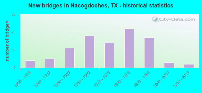
- New bridges - historical statistics
- 41930-1939
- 51940-1949
- 111950-1959
- 181960-1969
- 141970-1979
- 221980-1989
- 171990-1999
- 32000-2009
- 22010-2019
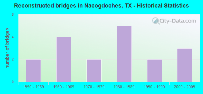
- Reconstructed bridges - Historical Statistics
- 21950-1959
- 41960-1969
- 21970-1979
- 51980-1989
- 21990-1999
- 32000-2009
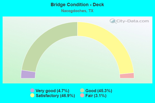
- Bridge Condition - Deck
- 4.7%Very good
- 45.3%Good
- 46.9%Satisfactory
- 3.1%Fair
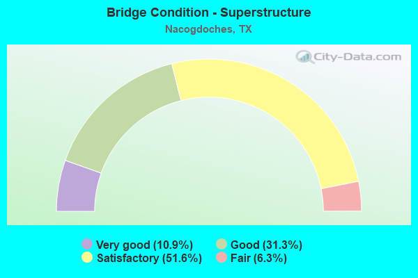
- Bridge Condition - Superstructure
- 10.9%Very good
- 31.3%Good
- 51.6%Satisfactory
- 6.3%Fair
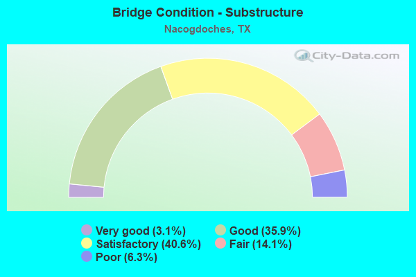
- Bridge Condition - Substructure
- 3.1%Very good
- 35.9%Good
- 40.6%Satisfactory
- 14.1%Fair
- 6.3%Poor
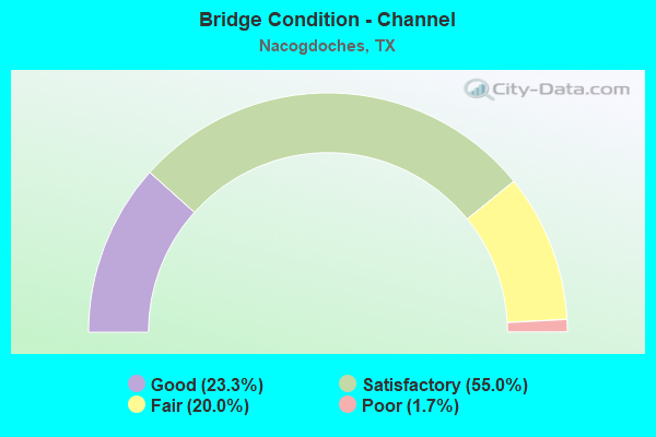
- Bridge Condition - Channel
- 23.3%Good
- 55.0%Satisfactory
- 20.0%Fair
- 1.7%Poor
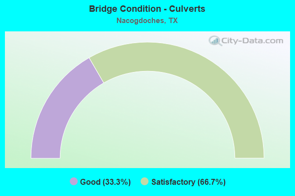
- Bridge Condition - Culverts
- 33.3%Good
- 66.7%Satisfactory
Find on map >> Show street view
Structure Number: 111740005901001, Location: 13.1 MI E JCT SH 21 (Lat: 31.638581, Lng: -94.423989), Route carried "on" structure: State highway 7, Year Built: 2009, Status: Open, Structure Length: 4.57m (14.99ft), Average Daily Traffic: 4,254 (year 2019), Truck Traffic: 18%, Average Future Daily Traffic: 8,000 (year 2036), Design Load: HS 20, Features Intersected: TERRAPIN CREEK
Minimum Vertical Clearance: 30+ m (98+ ft), Kilometerpoint: 21.073, Lanes on structure: 2, Owner: State Highway Agency, Approaching Roadway Width: 13.4m (44.0ft), Material/Design: Prestressed concrete, Design/Construction: Stringer/Multi-beam, Number Of Spans In Main Unit: 3, Length of Maximum Span: 15.2m (49.9ft), Curb-To-Curb Width: 13.4m (44.0ft), Out-to-Out Width: 14.1m (46.3ft)
Condition: Deck: Good, Superstructure: Very good, Substructure: Very good, Channel: Good, Operating Rating: 54.4 metric tons, Method Used To Determine Operating Rating: Assigned rating based on Load Factor Design (LFD) reported in metric tons, Inventory Rating: 32.7 metric tons, Method Used To Determine Inventory Rating: Assigned rating based on Load Factor Design (LFD) reported in metric tons, Structural Evaluation: Equal to present desirable criteria, Deck Geometry: Better than present minimum criteria, Waterway Adequacy: Superior to present desirable criteria, Approach Roadway Alignment: Equal to present desirable criteria, Designated Inspection Frequency: Every 24 months, Inspection Date: April 2020, Deck Structure Type: Concrete Precast Panels
Find on map >> Show street view
Structure Number: 111740005901027, Location: 2.6 MI E OF LOOP 224 (Lat: 31.603078, Lng: -94.572644), Route carried "on" structure: State highway 7, Year Built: 1935, Year Reconstructed: 1960, Status: Open, Structure Length: 5.21m (17.09ft), Average Daily Traffic: 5,175 (year 2019), Truck Traffic: 19%, Average Future Daily Traffic: 7,750 (year 2033), Design Load: H 15, Features Intersected: CARRIZO CREEK
Minimum Vertical Clearance: 30+ m (98+ ft), Kilometerpoint: 6.207, Lanes on structure: 2, Owner: State Highway Agency, Approaching Roadway Width: 12.8m (42.0ft), Material/Design: Concrete, Design/Construction: Tee Beam, Number Of Spans In Main Unit: 6, Length of Maximum Span: 8.5m (27.9ft), Curb-To-Curb Width: 13.2m (43.3ft), Out-to-Out Width: 14.1m (46.3ft)
Condition: Deck: Good, Superstructure: Satisfactory, Substructure: Satisfactory, Channel: Satisfactory, Operating Rating: 62.6 metric tons, Method Used To Determine Operating Rating: Load Factor (LF), Inventory Rating: 37.2 metric tons, Method Used To Determine Inventory Rating: Load Factor (LF), Structural Evaluation: Equal to present minimum criteria, Deck Geometry: Somewhat better than minimum adequacy, Waterway Adequacy: Equal to present minimum criteria, Approach Roadway Alignment: Equal to present desirable criteria, Designated Inspection Frequency: Every 24 months, Inspection Date: April 2020, Deck Structure Type: Concrete Cast-file-Place, Wearing Surface/Protective System: Wearing Surface: Bituminous
Find on map >> Show street view
Structure Number: 111740005901028, Location: 2.7 MI E OF LOOP 224 (Lat: 31.603047, Lng: -94.571303), Route carried "on" structure: State highway 7, Year Built: 1935, Year Reconstructed: 1960, Status: Open, Structure Length: 1.62m (5.31ft), Average Daily Traffic: 5,175 (year 2019), Truck Traffic: 19%, Average Future Daily Traffic: 7,750 (year 2033), Design Load: H 15, Features Intersected: CARRIZO CR RELIEF
Minimum Vertical Clearance: 30+ m (98+ ft), Kilometerpoint: 6.389, Lanes on structure: 2, Owner: State Highway Agency, Approaching Roadway Width: 13.4m (44.0ft), Material/Design: Concrete, Design/Construction: Culvert, Number Of Spans In Main Unit: 5, Length of Maximum Span: 3.0m (9.8ft), Curb-To-Curb Width: 13.4m (44.0ft), Out-to-Out Width: 14.2m (46.6ft)
Condition: Channel: Satisfactory, Culverts: Satisfactory, Operating Rating: 39.9 metric tons, Method Used To Determine Operating Rating: Load Factor (LF), Inventory Rating: 23.6 metric tons, Method Used To Determine Inventory Rating: Load Factor (LF), Structural Evaluation: Somewhat better than minimum adequacy, Deck Geometry: Equal to present minimum criteria, Waterway Adequacy: Equal to present minimum criteria, Approach Roadway Alignment: Equal to present desirable criteria, Designated Inspection Frequency: Every 24 months, Inspection Date: April 2020, Wearing Surface/Protective System: Wearing Surface: Bituminous
Find on map >> Show street view
Structure Number: 111740011806078, Location: 14.7 MI E OF ANGELINA RI (Lat: 31.623594, Lng: -94.725317), Route carried "on" structure: State highway 21, Year Built: 1987, Status: Open, Structure Length: 0.67m (2.20ft), Average Daily Traffic: 4,935 (year 2019), Truck Traffic: 12%, Average Future Daily Traffic: 5,290 (year 2033), Design Load: HS 20, Features Intersected: MORRAL CREEK RELIEF
Minimum Vertical Clearance: 30+ m (98+ ft), Kilometerpoint: 23.582, Lanes on structure: 2, Owner: State Highway Agency, Approaching Roadway Width: 13.4m (44.0ft), Material/Design: Concrete, Design/Construction: Culvert, Number Of Spans In Main Unit: 2, Length of Maximum Span: 3.0m (9.8ft)
Condition: Channel: Good, Culverts: Good, Operating Rating: 39.9 metric tons, Method Used To Determine Operating Rating: Load Factor (LF), Inventory Rating: 23.6 metric tons, Method Used To Determine Inventory Rating: Load Factor (LF), Structural Evaluation: Equal to present minimum criteria, Waterway Adequacy: Equal to present minimum criteria, Approach Roadway Alignment: Equal to present desirable criteria, Designated Inspection Frequency: Every 48 months, Inspection Date: April 2018
Find on map >> Show street view
Structure Number: 111740011806079, Location: 14.6 MI E ANGELINA RIVER (Lat: 31.623922, Lng: -94.726119), Route carried "on" structure: State highway 21, Year Built: 1987, Status: Open, Structure Length: 0.67m (2.20ft), Average Daily Traffic: 4,935 (year 2019), Truck Traffic: 12%, Average Future Daily Traffic: 5,290 (year 2033), Design Load: HS 20, Features Intersected: MORRAL CREEK
Minimum Vertical Clearance: 30+ m (98+ ft), Kilometerpoint: 23.485, Lanes on structure: 2, Owner: State Highway Agency, Approaching Roadway Width: 13.4m (44.0ft), Material/Design: Concrete, Design/Construction: Culvert, Number Of Spans In Main Unit: 2, Length of Maximum Span: 3.0m (9.8ft)
Condition: Channel: Satisfactory, Culverts: Good, Operating Rating: 39.9 metric tons, Method Used To Determine Operating Rating: Load Factor (LF), Inventory Rating: 23.6 metric tons, Method Used To Determine Inventory Rating: Load Factor (LF), Structural Evaluation: Equal to present minimum criteria, Waterway Adequacy: Equal to present minimum criteria, Approach Roadway Alignment: Equal to present desirable criteria, Designated Inspection Frequency: Every 48 months, Inspection Date: April 2018
Find on map >> Show street view
Structure Number: 11174001180608, Location: 3.20 MI W OF US 59 (Lat: 31.626475, Lng: -94.733894), Route carried "on" structure: State highway 21, Year Built: 1987, Status: Open, Structure Length: 0.67m (2.20ft), Average Daily Traffic: 4,935 (year 2019), Truck Traffic: 12%, Average Future Daily Traffic: 4,880 (year 2033), Design Load: HS 20, Features Intersected: MILL CREEK
Minimum Vertical Clearance: 30+ m (98+ ft), Kilometerpoint: 22.616, Lanes on structure: 2, Owner: State Highway Agency, Approaching Roadway Width: 13.4m (44.0ft), Material/Design: Concrete, Design/Construction: Culvert, Number Of Spans In Main Unit: 2, Length of Maximum Span: 3.0m (9.8ft), Curb-To-Curb Width: 13.7m (44.9ft), Out-to-Out Width: 26.0m (85.3ft)
Condition: Channel: Good, Culverts: Good, Operating Rating: 39.9 metric tons, Method Used To Determine Operating Rating: Load Factor (LF), Inventory Rating: 23.6 metric tons, Method Used To Determine Inventory Rating: Load Factor (LF), Structural Evaluation: Equal to present minimum criteria, Deck Geometry: Superior to present desirable criteria, Waterway Adequacy: Equal to present minimum criteria, Approach Roadway Alignment: Equal to present desirable criteria, Designated Inspection Frequency: Every 48 months, Inspection Date: April 2018, Deck Structure Type: Concrete Cast-file-Place, Wearing Surface/Protective System: Wearing Surface: Bituminous
Find on map >> Show street view
Structure Number: 111740011808055, Location: 0.5 MI E OF BUS 59 (Lat: 31.600922, Lng: -94.648317), Route carried "on" structure: State highway 7, Year Built: 1941, Year Reconstructed: 1963, Status: Open, Structure Length: 4.88m (16.01ft), Average Daily Traffic: 6,911 (year 2019), Truck Traffic: 22%, Average Future Daily Traffic: 10,300 (year 2033), Design Load: H 15, Features Intersected: LA NANA CREEK, Facility Carried by Structure: SH 21
Minimum Vertical Clearance: 30+ m (98+ ft), Kilometerpoint: 31.466, Lanes on structure: 4, Owner: State Highway Agency, Approaching Roadway Width: 14.3m (46.9ft), Material/Design: Concrete, Design/Construction: Slab, Number Of Spans In Main Unit: 8, Length of Maximum Span: 6.1m (20.0ft), Curb or Sidewalk Widths: Left: 1.2m (3.9ft), Right: 1.2m (3.9ft), Curb-To-Curb Width: 14.3m (46.9ft), Out-to-Out Width: 17.5m (57.4ft)
Condition: Deck: Good, Superstructure: Good, Substructure: Satisfactory, Channel: Satisfactory, Operating Rating: 37.2 metric tons, Method Used To Determine Operating Rating: Load Factor (LF), Inventory Rating: 22.7 metric tons, Method Used To Determine Inventory Rating: Load Factor (LF), Structural Evaluation: Somewhat better than minimum adequacy, Deck Geometry: High priority of replacement, Waterway Adequacy: Equal to present minimum criteria, Approach Roadway Alignment: Equal to present desirable criteria, Length Of Structure Improvement: 4.88m (16.01ft), Designated Inspection Frequency: Every 24 months, Inspection Date: April 2020, Bridge Improvement Cost: $15,000, Roadway Improvement Cost: $4,000, Total Project Cost: $19,000, Deck Structure Type: Concrete Cast-file-Place, Wearing Surface/Protective System: Wearing Surface: Bituminous
Find on map >> Show street view
Structure Number: 111740011808058, Location: 3.30 MI SE OF LOOP 224 (Lat: 31.573361, Lng: -94.564444), Route carried "on" structure: State highway 21, Year Built: 1954, Status: Open, Structure Length: 5.33m (17.49ft), Average Daily Traffic: 3,649 (year 2020), Truck Traffic: 9%, Average Future Daily Traffic: 6,650 (year 2033), Features Intersected: CARRIZO CREEK
Minimum Vertical Clearance: 30+ m (98+ ft), Kilometerpoint: 40.201, Lanes on structure: 2, Owner: State Highway Agency, Approaching Roadway Width: 9.1m (29.9ft), Material/Design: Concrete continuous, Design/Construction: Slab, Number Of Spans In Main Unit: 7, Length of Maximum Span: 7.6m (24.9ft), Curb-To-Curb Width: 8.3m (27.2ft), Out-to-Out Width: 9.5m (31.2ft)
Condition: Deck: Satisfactory, Superstructure: Satisfactory, Substructure: Satisfactory, Channel: Satisfactory, Operating Rating: 40.8 metric tons, Method Used To Determine Operating Rating: Load Factor (LF), Inventory Rating: 24.5 metric tons, Method Used To Determine Inventory Rating: Load Factor (LF), Structural Evaluation: Equal to present minimum criteria, Deck Geometry: High priority of corrective action, Waterway Adequacy: Equal to present minimum criteria, Approach Roadway Alignment: Equal to present desirable criteria, Length Of Structure Improvement: 5.33m (17.49ft), Designated Inspection Frequency: Every 24 months, Inspection Date: April 2020, Deck Structure Type: Concrete Cast-file-Place
Find on map >> Show street view
Structure Number: 11174001180807, Location: 0.20 MI W OF BUS 59 (Lat: 31.604964, Lng: -94.658353), Route carried "on" structure: State highway 21, Year Built: 1957, Status: Open, Structure Length: 3.05m (10.01ft), Average Daily Traffic: 7,745 (year 2020), Truck Traffic: 12%, Average Future Daily Traffic: 11,720 (year 2033), Features Intersected: BANITA CREEK
Minimum Vertical Clearance: 30+ m (98+ ft), Kilometerpoint: 30.428, Lanes on structure: 4, Owner: State Highway Agency, Approaching Roadway Width: 12.5m (41.0ft), Material/Design: Concrete, Design/Construction: Slab, Number Of Spans In Main Unit: 4, Length of Maximum Span: 7.6m (24.9ft), Curb or Sidewalk Widths: Left: 1.2m (3.9ft), Right: 1.2m (3.9ft), Curb-To-Curb Width: 12.5m (41.0ft), Out-to-Out Width: 15.3m (50.2ft)
Condition: Deck: Satisfactory, Superstructure: Satisfactory, Substructure: Satisfactory, Channel: Good, Operating Rating: 50.8 metric tons, Method Used To Determine Operating Rating: Load Factor (LF), Inventory Rating: 30.8 metric tons, Method Used To Determine Inventory Rating: Load Factor (LF), Structural Evaluation: Equal to present minimum criteria, Deck Geometry: High priority of replacement, Waterway Adequacy: Equal to present minimum criteria, Approach Roadway Alignment: Equal to present desirable criteria, Length Of Structure Improvement: 3.05m (10.01ft), Designated Inspection Frequency: Every 24 months, Inspection Date: April 2020, Bridge Improvement Cost: $8,000, Roadway Improvement Cost: $2,000, Total Project Cost: $10,000, Deck Structure Type: Concrete Cast-file-Place, Wearing Surface/Protective System: Wearing Surface: Bituminous
Find on map >> Show street view
Structure Number: 111740011808071, Location: AT JCT OF LP 224 & SH 21E (Lat: 31.589425, Lng: -94.619567), Route carried "on" structure: State highway 224, Year Built: 1964, Status: Open, Structure Length: 5.52m (18.11ft), Average Daily Traffic: 9,090 (year 2012), Truck Traffic: 6%, Average Future Daily Traffic: 14,020 (year 2034), Design Load: H 20, Features Intersected: SH 21
Minimum Vertical Clearance: 30+ m (98+ ft), Kilometerpoint: 17.226, Lanes on structure: 2, Lanes under structure: 4, Owner: State Highway Agency, Approaching Roadway Width: 12.8m (42.0ft), Material/Design: Prestressed concrete, Design/Construction: Stringer/Multi-beam, Number Of Spans In Main Unit: 4, Length of Maximum Span: 13.7m (44.9ft), Curb-To-Curb Width: 12.6m (41.3ft), Out-to-Out Width: 13.5m (44.3ft)
Condition: Deck: Good, Superstructure: Satisfactory, Substructure: Good, Operating Rating: 68.0 metric tons, Method Used To Determine Operating Rating: Load Factor (LF), Inventory Rating: 40.8 metric tons, Method Used To Determine Inventory Rating: Load Factor (LF), Structural Evaluation: Equal to present minimum criteria, Deck Geometry: Somewhat better than minimum adequacy, Underclear: Meets minimum limits, Approach Roadway Alignment: Equal to present desirable criteria, Designated Inspection Frequency: Every 24 months, Inspection Date: May 2020, Deck Structure Type: Concrete Cast-file-Place, Wearing Surface/Protective System: Wearing Surface: Bituminous
Find on map >> Show street view
Structure Number: 111740017508024, Location: 17.5 MI S OF RUSK CO LN (Lat: 31.662522, Lng: -94.659400), Route carried "on" structure: State highway 59, Year Built: 1940, Year Reconstructed: 1959, Status: Open, Structure Length: 4.75m (15.58ft), Average Daily Traffic: 6,480 (year 2013), Truck Traffic: 29%, Average Future Daily Traffic: 9,070 (year 2033), Design Load: H 15, Features Intersected: T & NO RR
Minimum Vertical Clearance: 30+ m (98+ ft), Kilometerpoint: 28.073, Lanes on structure: 2, Owner: State Highway Agency, Approaching Roadway Width: 7.3m (24.0ft), Material/Design: Steel, Design/Construction: Stringer/Multi-beam, Number Of Spans In Main Unit: 3, Length of Maximum Span: 15.9m (52.2ft), Curb or Sidewalk Widths: Left: 0.8m (2.6ft), Right: 0.5m (1.6ft), Curb-To-Curb Width: 8.5m (27.9ft), Out-to-Out Width: 9.8m (32.2ft)
Condition: Deck: Satisfactory, Superstructure: Satisfactory, Substructure: Satisfactory, Operating Rating: 39.9 metric tons, Method Used To Determine Operating Rating: Load Factor (LF), Inventory Rating: 23.6 metric tons, Method Used To Determine Inventory Rating: Load Factor (LF), Structural Evaluation: Somewhat better than minimum adequacy, Deck Geometry: High priority of corrective action, Underclear: Somewhat better than minimum adequacy, Approach Roadway Alignment: Equal to present desirable criteria, Length Of Structure Improvement: 4.75m (15.58ft), Designated Inspection Frequency: Every 24 months, Inspection Date: April 2020, Bridge Improvement Cost: $9,000, Roadway Improvement Cost: $2,000, Total Project Cost: $11,000, Deck Structure Type: Concrete Cast-file-Place, Wearing Surface/Protective System: Wearing Surface: Bituminous
Find on map >> Show street view
Structure Number: 111740017508032, Location: 17.5 MI S OF RUSK CO LN (Lat: 31.662683, Lng: -94.659808), Route carried "on" structure: State highway 59, Year Built: 1959, Status: Open, Structure Length: 5.09m (16.70ft), Average Daily Traffic: 15,501 (year 2018), Truck Traffic: 29%, Average Future Daily Traffic: 9,070 (year 2033), Features Intersected: T & NO RR
Minimum Vertical Clearance: 30+ m (98+ ft), Kilometerpoint: 28.073, Lanes on structure: 2, Owner: State Highway Agency, Approaching Roadway Width: 7.3m (24.0ft), Material/Design: Steel continuous, Design/Construction: Stringer/Multi-beam, Number Of Spans In Main Unit: 3, Length of Maximum Span: 16.8m (55.1ft), Curb or Sidewalk Widths: Left: 0.5m (1.6ft), Right: 0.8m (2.6ft), Curb-To-Curb Width: 8.5m (27.9ft), Out-to-Out Width: 9.8m (32.2ft)
Condition: Deck: Satisfactory, Superstructure: Fair, Substructure: Good, Operating Rating: 38.1 metric tons, Method Used To Determine Operating Rating: Load Factor (LF), Inventory Rating: 23.6 metric tons, Method Used To Determine Inventory Rating: Load Factor (LF), Structural Evaluation: Somewhat better than minimum adequacy, Deck Geometry: High priority of corrective action, Underclear: Somewhat better than minimum adequacy, Approach Roadway Alignment: Equal to present desirable criteria, Length Of Structure Improvement: 5.09m (16.70ft), Designated Inspection Frequency: Every 24 months, Inspection Date: April 2020, Bridge Improvement Cost: $9,000, Roadway Improvement Cost: $2,000, Total Project Cost: $11,000, Deck Structure Type: Concrete Cast-file-Place
Find on map >> Show street view
Structure Number: 111740017601043, Location: 0.20 MI S OF SH 21 (Lat: 31.601897, Lng: -94.657069), Route carried "on" structure: State highway 7, Year Built: 1940, Year Reconstructed: 1967, Status: Open, Structure Length: 3.66m (12.01ft), Average Daily Traffic: 13,839 (year 2020), Truck Traffic: 18%, Average Future Daily Traffic: 22,390 (year 2033), Features Intersected: BANITA CREEK, Facility Carried by Structure: BUS 59
Minimum Vertical Clearance: 30+ m (98+ ft), Kilometerpoint: 2.964, Lanes on structure: 4, Owner: State Highway Agency, Approaching Roadway Width: 17.7m (58.1ft), Skew: 19 degrees, Material/Design: Concrete, Design/Construction: Culvert, Number Of Spans In Main Unit: 9, Length of Maximum Span: 3.7m (12.1ft), Curb or Sidewalk Widths: Left: 1.2m (3.9ft), Right: 1.5m (4.9ft), Curb-To-Curb Width: 17.7m (58.1ft), Out-to-Out Width: 20.1m (65.9ft)
Condition: Channel: Satisfactory, Culverts: Satisfactory, Operating Rating: 39.9 metric tons, Method Used To Determine Operating Rating: Load Factor (LF), Inventory Rating: 23.6 metric tons, Method Used To Determine Inventory Rating: Load Factor (LF), Structural Evaluation: Somewhat better than minimum adequacy, Deck Geometry: Somewhat better than minimum adequacy, Waterway Adequacy: Equal to present minimum criteria, Approach Roadway Alignment: Equal to present desirable criteria, Length Of Structure Improvement: 3.81m (12.50ft), Designated Inspection Frequency: Every 24 months, Inspection Date: April 2020, Deck Structure Type: Concrete Cast-file-Place, Wearing Surface/Protective System: Wearing Surface: Bituminous
Find on map >> Show street view
Structure Number: 111740017601044, Location: 0.30 MI S OF SH 21 (Lat: 31.599192, Lng: -94.659069), Route carried "on" structure: State highway 59, Year Built: 1967, Status: Open, Structure Length: 29.99m (98.39ft), Average Daily Traffic: 15,990 (year 2013), Truck Traffic: 18%, Average Future Daily Traffic: 22,390 (year 2033), Design Load: H 20, Features Intersected: SPRR & COX ST
Minimum Vertical Clearance: 30+ m (98+ ft), Kilometerpoint: 2.908, Lanes on structure: 2, Lanes under structure: 2, Owner: State Highway Agency, Approaching Roadway Width: 7.9m (25.9ft), Skew: 9 degrees, Material/Design: Prestressed concrete, Design/Construction: Stringer/Multi-beam, Number Of Spans In Main Unit: 13, Number Of Approach Spans: 3, Length of Maximum Span: 21.0m (68.9ft), Curb or Sidewalk Widths: Left: 0.0m, Right: 1.2m (3.9ft), Curb-To-Curb Width: 8.6m (28.2ft), Out-to-Out Width: 10.6m (34.8ft)
Condition: Deck: Satisfactory, Superstructure: Good, Substructure: Satisfactory, Operating Rating: 52.6 metric tons, Method Used To Determine Operating Rating: Load Factor (LF), Inventory Rating: 28.1 metric tons, Method Used To Determine Inventory Rating: Load Factor (LF), Structural Evaluation: Equal to present minimum criteria, Deck Geometry: High priority of corrective action, Underclear: Equal to present minimum criteria, Approach Roadway Alignment: Equal to present desirable criteria, Length Of Structure Improvement: 29.99m (98.39ft), Designated Inspection Frequency: Every 24 months, Inspection Date: April 2020, Bridge Improvement Cost: $55,000, Roadway Improvement Cost: $14,000, Total Project Cost: $69,000, Deck Structure Type: Concrete Cast-file-Place
Find on map >> Show street view
Structure Number: 111740017601045, Location: 22.1 MI S OF RUSK CO LINE (Lat: 31.597567, Lng: -94.660614), Route carried "on" structure: State highway 7, Year Built: 1940, Year Reconstructed: 1967, Status: Open, Structure Length: 0.79m (2.59ft), Average Daily Traffic: 13,839 (year 2020), Truck Traffic: 18%, Average Future Daily Traffic: 22,390 (year 2033), Features Intersected: RUSK BRANCH, Facility Carried by Structure: BUS 59
Minimum Vertical Clearance: 30+ m (98+ ft), Kilometerpoint: 2.361, Lanes on structure: 5, Owner: State Highway Agency, Approaching Roadway Width: 16.8m (55.1ft), Skew: 23 degrees, Material/Design: Concrete, Design/Construction: Culvert, Number Of Spans In Main Unit: 3, Length of Maximum Span: 2.4m (7.9ft)
Condition: Channel: Good, Culverts: Satisfactory, Operating Rating: 39.9 metric tons, Method Used To Determine Operating Rating: Load Factor (LF), Inventory Rating: 23.6 metric tons, Method Used To Determine Inventory Rating: Load Factor (LF), Structural Evaluation: Somewhat better than minimum adequacy, Waterway Adequacy: Equal to present minimum criteria, Approach Roadway Alignment: Equal to present desirable criteria, Length Of Structure Improvement: 0.82m (2.69ft), Designated Inspection Frequency: Every 24 months, Inspection Date: April 2020
Find on map >> Show street view
Structure Number: 111740017601088, Location: JCT US 59 & LP 224 (Lat: 31.576844, Lng: -94.672442), Route carried "on" structure: US 59, Year Built: 1979, Status: Open, Structure Length: 6.10m (20.01ft), Average Daily Traffic: 12,470 (year 2013), Truck Traffic: 22%, Average Future Daily Traffic: 17,460 (year 2033), Design Load: HS 20, Features Intersected: US 59, Facility Carried by Structure: LP 224 EB
Minimum Vertical Clearance: 30+ m (98+ ft), Kilometerpoint: 15.735, Lanes on structure: 2, Lanes under structure: 6, Owner: State Highway Agency, Approaching Roadway Width: 11.0m (36.1ft), Material/Design: Prestressed concrete, Design/Construction: Stringer/Multi-beam, Number Of Spans In Main Unit: 4, Length of Maximum Span: 16.8m (55.1ft), Curb-To-Curb Width: 10.9m (35.8ft), Out-to-Out Width: 11.6m (38.1ft)
Condition: Deck: Good, Superstructure: Good, Substructure: Good, Operating Rating: 54.4 metric tons, Method Used To Determine Operating Rating: Assigned rating based on Load Factor Design (LFD) reported in metric tons, Inventory Rating: 32.7 metric tons, Method Used To Determine Inventory Rating: Assigned rating based on Load Factor Design (LFD) reported in metric tons, Structural Evaluation: Better than present minimum criteria, Deck Geometry: Somewhat better than minimum adequacy, Underclear: Meets minimum limits, Approach Roadway Alignment: Equal to present desirable criteria, Designated Inspection Frequency: Every 24 months, Inspection Date: April 2020, Deck Structure Type: Concrete Precast Panels
Find on map >> Show street view
Structure Number: 111740017601141, Location: 0.3 MI S OF SH 21 (Lat: 31.601717, Lng: -94.657183), Route carried "on" structure: State highway 59, Year Built: 1938, Status: Open, Structure Length: 29.99m (98.39ft), Average Daily Traffic: 8,450 (year 2016), Truck Traffic: 12%, Average Future Daily Traffic: 25,520 (year 2036), Design Load: H 15, Features Intersected: SPRR & COX ST
Minimum Vertical Clearance: 30+ m (98+ ft), Kilometerpoint: 2.908, Lanes on structure: 2, Lanes under structure: 2, Owner: State Highway Agency, Approaching Roadway Width: 7.9m (25.9ft), Skew: 9 degrees, Material/Design: Steel, Design/Construction: Stringer/Multi-beam, Number Of Spans In Main Unit: 1, Number Of Approach Spans: 28, Length of Maximum Span: 20.7m (67.9ft), Curb or Sidewalk Widths: Left: 0.0m, Right: 0.9m (3.0ft), Curb-To-Curb Width: 8.5m (27.9ft), Out-to-Out Width: 10.5m (34.4ft)
Condition: Deck: Fair, Superstructure: Satisfactory, Substructure: Good, Operating Rating: 51.7 metric tons, Method Used To Determine Operating Rating: Load Factor (LF), Inventory Rating: 30.8 metric tons, Method Used To Determine Inventory Rating: Load Factor (LF), Structural Evaluation: Equal to present minimum criteria, Deck Geometry: High priority of corrective action, Underclear: Equal to present minimum criteria, Approach Roadway Alignment: Equal to present desirable criteria, Length Of Structure Improvement: 29.99m (98.39ft), Designated Inspection Frequency: Every 24 months, Inspection Date: April 2020, Bridge Improvement Cost: $55,000, Roadway Improvement Cost: $14,000, Total Project Cost: $69,000, Deck Structure Type: Concrete Cast-file-Place
Find on map >> Show street view
Structure Number: 111740055303002, Location: 4.9 MI SW OF LOOP 224 (Lat: 31.542231, Lng: -94.747719), Route carried "on" structure: State highway 7, Year Built: 1952, Year Reconstructed: 2008, Status: Open, Structure Length: 0.85m (2.79ft), Average Daily Traffic: 3,876 (year 2020), Truck Traffic: 18%, Average Future Daily Traffic: 4,990 (year 2033), Features Intersected: BLACK BRANCH
Minimum Vertical Clearance: 30+ m (98+ ft), Kilometerpoint: 9.883, Lanes on structure: 3, Owner: State Highway Agency, Approaching Roadway Width: 15.5m (50.9ft), Material/Design: Concrete, Design/Construction: Culvert, Number Of Spans In Main Unit: 3, Length of Maximum Span: 2.7m (8.9ft)
Condition: Channel: Fair, Culverts: Good, Operating Rating: 39.9 metric tons, Method Used To Determine Operating Rating: Load Factor (LF), Inventory Rating: 23.6 metric tons, Method Used To Determine Inventory Rating: Load Factor (LF), Structural Evaluation: Equal to present minimum criteria, Waterway Adequacy: Equal to present minimum criteria, Approach Roadway Alignment: Equal to present desirable criteria, Designated Inspection Frequency: Every 24 months, Inspection Date: April 2020
Find on map >> Show street view
Structure Number: 111740055303003, Location: 4.1 MI SW OF LOOP 224 (Lat: 31.549642, Lng: -94.736289), Route carried "on" structure: State highway 7, Year Built: 1952, Status: Open, Structure Length: 5.46m (17.91ft), Average Daily Traffic: 3,876 (year 2020), Truck Traffic: 18%, Average Future Daily Traffic: 4,990 (year 2033), Features Intersected: MORRAL CREEK
Minimum Vertical Clearance: 30+ m (98+ ft), Kilometerpoint: 11.079, Lanes on structure: 2, Owner: State Highway Agency, Approaching Roadway Width: 13.4m (44.0ft), Skew: 3 degrees, Material/Design: Concrete, Design/Construction: Slab, Number Of Spans In Main Unit: 7, Length of Maximum Span: 7.6m (24.9ft), Curb-To-Curb Width: 7.9m (25.9ft), Out-to-Out Width: 8.9m (29.2ft)
Condition: Deck: Good, Superstructure: Good, Substructure: Satisfactory, Channel: Good, Operating Rating: 46.3 metric tons, Method Used To Determine Operating Rating: Load Factor (LF), Inventory Rating: 27.2 metric tons, Method Used To Determine Inventory Rating: Load Factor (LF), Structural Evaluation: Equal to present minimum criteria, Deck Geometry: High priority of corrective action, Waterway Adequacy: Equal to present minimum criteria, Approach Roadway Alignment: Equal to present desirable criteria, Length Of Structure Improvement: 5.30m (17.39ft), Designated Inspection Frequency: Every 24 months, Inspection Date: April 2020, Bridge Improvement Cost: $9,000, Roadway Improvement Cost: $2,000, Total Project Cost: $11,000, Deck Structure Type: Concrete Cast-file-Place, Wearing Surface/Protective System: Wearing Surface: Bituminous
Find on map >> Show street view
Structure Number: 111740140702001, Location: 0.40 MI W OF BUS 59 (Lat: 31.610778, Lng: -94.657878), Route carried "on" structure: State highway 1638, Year Built: 1956, Status: Open, Structure Length: 3.81m (12.50ft), Average Daily Traffic: 1,553 (year 2020), Truck Traffic: 10%, Average Future Daily Traffic: 2,810 (year 2033), Features Intersected: BANITA CREEK
Minimum Vertical Clearance: 30+ m (98+ ft), Kilometerpoint: 11.217, Lanes on structure: 2, Owner: State Highway Agency, Approaching Roadway Width: 7.9m (25.9ft), Material/Design: Concrete, Design/Construction: Slab, Number Of Spans In Main Unit: 5, Length of Maximum Span: 7.6m (24.9ft), Curb or Sidewalk Widths: Left: 0.5m (1.6ft), Right: 0.5m (1.6ft), Curb-To-Curb Width: 8.5m (27.9ft), Out-to-Out Width: 9.5m (31.2ft)
Condition: Deck: Fair, Superstructure: Fair, Substructure: Fair, Channel: Satisfactory, Operating Rating: 44.4 metric tons, Method Used To Determine Operating Rating: Load Factor (LF), Inventory Rating: 26.3 metric tons, Method Used To Determine Inventory Rating: Load Factor (LF), Structural Evaluation: Somewhat better than minimum adequacy, Deck Geometry: Somewhat better than minimum adequacy, Waterway Adequacy: Equal to present minimum criteria, Approach Roadway Alignment: Equal to present desirable criteria, Designated Inspection Frequency: Every 24 months, Inspection Date: April 2020, Deck Structure Type: Concrete Cast-file-Place
Find on map >> Show street view
Structure Number: 111740140703003, Location: 1.6 MI N OF SH 21 (Lat: 31.621167, Lng: -94.639819), Route carried "on" structure: State highway 1275, Year Built: 1970, Year Reconstructed: 2009, Status: Open, Structure Length: 0.67m (2.20ft), Average Daily Traffic: 13,648 (year 2020), Truck Traffic: 10%, Average Future Daily Traffic: 23,520 (year 2033), Design Load: HS 20, Features Intersected: BURROWS BRANCH
Minimum Vertical Clearance: 30+ m (98+ ft), Kilometerpoint: 5.082, Lanes on structure: 4, Owner: State Highway Agency, Approaching Roadway Width: 21.0m (68.9ft), Skew: 1 degrees, Material/Design: Concrete, Design/Construction: Culvert, Number Of Spans In Main Unit: 2, Length of Maximum Span: 3.0m (9.8ft), Curb or Sidewalk Widths: Left: 2.4m (7.9ft), Right: 0.0m
Condition: Channel: Satisfactory, Culverts: Good, Operating Rating: 39.9 metric tons, Method Used To Determine Operating Rating: Load Factor (LF), Inventory Rating: 23.6 metric tons, Method Used To Determine Inventory Rating: Load Factor (LF), Structural Evaluation: Somewhat better than minimum adequacy, Waterway Adequacy: Equal to present minimum criteria, Approach Roadway Alignment: Equal to present desirable criteria, Designated Inspection Frequency: Every 24 months, Inspection Date: April 2020
Find on map >> Show street view
Structure Number: 111740140703004, Location: 0.8 MI S OF LOOP 224 (Lat: 31.639872, Lng: -94.639858), Route carried "on" structure: State highway 1275, Year Built: 1981, Status: Open, Structure Length: 0.88m (2.89ft), Average Daily Traffic: 10,733 (year 2019), Truck Traffic: 17%, Average Future Daily Traffic: 6,630 (year 2033), Design Load: HS 20, Features Intersected: TRIB OF LA NANA BAYOU
Minimum Vertical Clearance: 30+ m (98+ ft), Kilometerpoint: 3.006, Lanes on structure: 4, Owner: State Highway Agency, Approaching Roadway Width: 15.9m (52.2ft), Material/Design: Concrete, Design/Construction: Culvert, Number Of Spans In Main Unit: 3, Length of Maximum Span: 2.7m (8.9ft)
Condition: Channel: Satisfactory, Culverts: Satisfactory, Operating Rating: 39.9 metric tons, Method Used To Determine Operating Rating: Load Factor (LF), Inventory Rating: 23.6 metric tons, Method Used To Determine Inventory Rating: Load Factor (LF), Structural Evaluation: Somewhat better than minimum adequacy, Waterway Adequacy: Equal to present minimum criteria, Approach Roadway Alignment: Equal to present desirable criteria, Designated Inspection Frequency: Every 24 months, Inspection Date: April 2020
Find on map >> Show street view
Structure Number: 111740181001004, Location: 2.5 MI NE OF LOOP 224 (Lat: 31.652339, Lng: -94.579756), Route carried "on" structure: State highway 1878, Year Built: 1956, Year Reconstructed: 1987, Status: Open, Structure Length: 3.05m (10.01ft), Average Daily Traffic: 1,057 (year 2020), Truck Traffic: 15%, Average Future Daily Traffic: 1,690 (year 2033), Features Intersected: CARRIZO CREEK
Minimum Vertical Clearance: 30+ m (98+ ft), Kilometerpoint: 8.309, Lanes on structure: 2, Owner: State Highway Agency, Approaching Roadway Width: 6.4m (21.0ft), Material/Design: Concrete, Design/Construction: Slab, Number Of Spans In Main Unit: 4, Length of Maximum Span: 7.6m (24.9ft), Curb-To-Curb Width: 11.9m (39.0ft), Out-to-Out Width: 12.8m (42.0ft)
Condition: Deck: Good, Superstructure: Good, Substructure: Satisfactory, Channel: Satisfactory, Operating Rating: 46.3 metric tons, Method Used To Determine Operating Rating: Load Factor (LF), Inventory Rating: 24.5 metric tons, Method Used To Determine Inventory Rating: Load Factor (LF), Structural Evaluation: Equal to present minimum criteria, Deck Geometry: Equal to present minimum criteria, Waterway Adequacy: Superior to present desirable criteria, Approach Roadway Alignment: Equal to present desirable criteria, Length Of Structure Improvement: 3.05m (10.01ft), Designated Inspection Frequency: Every 24 months, Inspection Date: May 2020, Deck Structure Type: Concrete Cast-file-Place, Wearing Surface/Protective System: Wearing Surface: Bituminous
Find on map >> Show street view
Structure Number: 11174018100102, Location: 0.70 MI E OF BUS 59 (Lat: 31.617650, Lng: -94.641525), Route carried "on" structure: State highway 1878, Year Built: 2018, Status: Open, Structure Length: 4.88m (16.01ft), Average Daily Traffic: 8,522 (year 2020), Truck Traffic: 5%, Average Future Daily Traffic: 17,610 (year 2033), Design Load: HL 93, Features Intersected: LA NANA CREEK
Minimum Vertical Clearance: 30+ m (98+ ft), Kilometerpoint: 1.110, Lanes on structure: 4, Owner: State Highway Agency, Approaching Roadway Width: 16.5m (54.1ft), Material/Design: Prestressed concrete, Design/Construction: Slab, Number Of Spans In Main Unit: 2, Number Of Approach Spans: 2, Length of Maximum Span: 15.2m (49.9ft), Curb or Sidewalk Widths: Left: 1.5m (4.9ft), Right: 1.5m (4.9ft), Curb-To-Curb Width: 16.5m (54.1ft), Out-to-Out Width: 20.7m (67.9ft)
Condition: Deck: Good, Superstructure: Very good, Substructure: Very good, Channel: Good, Operating Rating: 54.4 metric tons, Method Used To Determine Operating Rating: Assigned ratings based on Load and Resistance Factor Design (LRFD) reported in metric tons, Inventory Rating: 32.7 metric tons, Method Used To Determine Inventory Rating: Assigned ratings based on Load and Resistance Factor Design (LRFD) reported in metric tons, Structural Evaluation: Equal to present desirable criteria, Deck Geometry: Meets minimum limits, Waterway Adequacy: Equal to present minimum criteria, Approach Roadway Alignment: Equal to present desirable criteria, Designated Inspection Frequency: Every 24 months, Inspection Date: June 2020, Deck Structure Type: Concrete Cast-file-Place
Find on map >> Show street view
Structure Number: 111740181002002, Location: 2.6 MI W OF US 59 (Lat: 31.582564, Lng: -94.724331), Route carried "on" structure: State highway 225, Year Built: 1955, Status: Open, Structure Length: 3.05m (10.01ft), Average Daily Traffic: 1,891 (year 2020), Truck Traffic: 12%, Average Future Daily Traffic: 2,330 (year 2033), Features Intersected: MORRAL BAYOU
Minimum Vertical Clearance: 30+ m (98+ ft), Kilometerpoint: 25.492, Lanes on structure: 2, Owner: State Highway Agency, Approaching Roadway Width: 6.7m (22.0ft), Material/Design: Concrete, Design/Construction: Slab, Number Of Spans In Main Unit: 4, Length of Maximum Span: 7.6m (24.9ft), Curb-To-Curb Width: 7.1m (23.3ft), Out-to-Out Width: 7.7m (25.3ft)
Condition: Deck: Good, Superstructure: Good, Substructure: Satisfactory, Channel: Good, Operating Rating: 47.2 metric tons, Method Used To Determine Operating Rating: Load Factor (LF), Inventory Rating: 24.5 metric tons, Method Used To Determine Inventory Rating: Load Factor (LF), Structural Evaluation: Equal to present minimum criteria, Deck Geometry: High priority of corrective action, Waterway Adequacy: Equal to present minimum criteria, Approach Roadway Alignment: Equal to present desirable criteria, Length Of Structure Improvement: 3.05m (10.01ft), Designated Inspection Frequency: Every 24 months, Inspection Date: April 2020, Bridge Improvement Cost: $5,000, Roadway Improvement Cost: $1,000, Total Project Cost: $6,000, Deck Structure Type: Concrete Cast-file-Place, Wearing Surface/Protective System: Wearing Surface: Bituminous
Find on map >> Show street view
Structure Number: 111740181002003, Location: 1.0 MI E OF FM 2782 (Lat: 31.584683, Lng: -94.768272), Route carried "on" structure: State highway 225, Year Built: 1955, Year Reconstructed: 1987, Status: Open, Structure Length: 0.64m (2.10ft), Average Daily Traffic: 1,891 (year 2020), Truck Traffic: 12%, Average Future Daily Traffic: 2,330 (year 2033), Features Intersected: ALAZAN BAYOU
Minimum Vertical Clearance: 30+ m (98+ ft), Kilometerpoint: 21.304, Lanes on structure: 2, Owner: State Highway Agency, Approaching Roadway Width: 11.3m (37.1ft), Material/Design: Concrete, Design/Construction: Culvert, Number Of Spans In Main Unit: 2, Length of Maximum Span: 3.0m (9.8ft)
Condition: Channel: Fair, Culverts: Satisfactory, Operating Rating: 39.9 metric tons, Method Used To Determine Operating Rating: Load Factor (LF), Inventory Rating: 23.6 metric tons, Method Used To Determine Inventory Rating: Load Factor (LF), Structural Evaluation: Equal to present minimum criteria, Waterway Adequacy: Equal to present minimum criteria, Approach Roadway Alignment: Equal to present desirable criteria, Designated Inspection Frequency: Every 24 months, Inspection Date: April 2020
Find on map >> Show street view
Structure Number: 111740230001002, Location: 2.30 MI W OF US 59 (Lat: 31.666389, Lng: -94.713889), Route carried "on" structure: State highway 343, Year Built: 1958, Status: Open, Structure Length: 0.67m (2.20ft), Average Daily Traffic: 2,255 (year 2020), Truck Traffic: 11%, Average Future Daily Traffic: 3,320 (year 2033), Features Intersected: MORRAL CREEK
Minimum Vertical Clearance: 30+ m (98+ ft), Kilometerpoint: 31.450, Lanes on structure: 2, Owner: State Highway Agency, Approaching Roadway Width: 6.4m (21.0ft), Material/Design: Concrete, Design/Construction: Culvert, Number Of Spans In Main Unit: 2, Length of Maximum Span: 3.0m (9.8ft), Curb-To-Curb Width: 6.4m (21.0ft), Out-to-Out Width: 11.1m (36.4ft)
Condition: Channel: Fair, Culverts: Satisfactory, Operating Rating: 39.9 metric tons, Method Used To Determine Operating Rating: Load Factor (LF), Inventory Rating: 23.6 metric tons, Method Used To Determine Inventory Rating: Load Factor (LF), Structural Evaluation: Equal to present minimum criteria, Deck Geometry: High priority of replacement, Waterway Adequacy: Equal to present minimum criteria, Approach Roadway Alignment: Equal to present desirable criteria, Length Of Structure Improvement: 0.67m (2.20ft), Designated Inspection Frequency: Every 24 months, Inspection Date: May 2020, Bridge Improvement Cost: $1,000, Total Project Cost: $1,000
Find on map >> Show street view
Structure Number: 11174023000101, Location: JCT FM 343 & US 59 (Lat: 31.666933, Lng: -94.675269), Route carried "on" structure: State highway 343, Year Built: 1966, Year Reconstructed: 1984, Status: Open, Structure Length: 1.10m (3.61ft), Average Daily Traffic: 858 (year 2020), Truck Traffic: 18%, Average Future Daily Traffic: 1,060 (year 2033), Features Intersected: BONITA CREEK
Minimum Vertical Clearance: 30+ m (98+ ft), Kilometerpoint: 35.161, Lanes on structure: 6, Owner: State Highway Agency, Approaching Roadway Width: 37.2m (122.0ft), Skew: 3 degrees, Material/Design: Concrete, Design/Construction: Culvert, Number Of Spans In Main Unit: 3, Length of Maximum Span: 3.0m (9.8ft)
Condition: Channel: Fair, Culverts: Satisfactory, Operating Rating: 39.9 metric tons, Method Used To Determine Operating Rating: Load Factor (LF), Inventory Rating: 23.6 metric tons, Method Used To Determine Inventory Rating: Load Factor (LF), Structural Evaluation: Equal to present minimum criteria, Waterway Adequacy: Superior to present desirable criteria, Approach Roadway Alignment: Equal to present desirable criteria, Designated Inspection Frequency: Every 24 months, Inspection Date: April 2020
Find on map >> Show street view
Structure Number: 111740256001001, Location: 0.90 MI E OF US 59 (Lat: 31.576086, Lng: -94.657797), Route carried "on" structure: State highway 224, Year Built: 1964, Year Reconstructed: 1988, Status: Open, Structure Length: 9.21m (30.22ft), Average Daily Traffic: 16,923 (year 2019), Truck Traffic: 9%, Average Future Daily Traffic: 22,690 (year 2033), Design Load: H 20, Features Intersected: SPRR & DRAW & PRESS RD
Minimum Vertical Clearance: 30+ m (98+ ft), Kilometerpoint: 21.522, Lanes on structure: 5, Lanes under structure: 1, Owner: State Highway Agency, Approaching Roadway Width: 25.6m (84.0ft), Skew: 1 degrees, Material/Design: Prestressed concrete, Design/Construction: Stringer/Multi-beam, Number Of Spans In Main Unit: 6, Length of Maximum Span: 15.2m (49.9ft), Curb-To-Curb Width: 25.6m (84.0ft), Out-to-Out Width: 26.2m (86.0ft)
Condition: Deck: Satisfactory, Superstructure: Very good, Substructure: Satisfactory, Channel: Satisfactory, Operating Rating: 56.2 metric tons, Method Used To Determine Operating Rating: Load Factor (LF), Inventory Rating: 29.9 metric tons, Method Used To Determine Inventory Rating: Load Factor (LF), Structural Evaluation: Equal to present minimum criteria, Deck Geometry: Superior to present desirable criteria, Underclear: Meets minimum limits, Waterway Adequacy: Superior to present desirable criteria, Approach Roadway Alignment: Equal to present desirable criteria, Designated Inspection Frequency: Every 24 months, Inspection Date: April 2020, Deck Structure Type: Concrete Cast-file-Place
Find on map >> Show street view
Structure Number: 111740256001002, Location: 1.1 MI E OF US 59 (Lat: 31.577133, Lng: -94.654811), Route carried "on" structure: State highway 224, Year Built: 1964, Year Reconstructed: 1988, Status: Open, Structure Length: 9.75m (31.99ft), Average Daily Traffic: 16,923 (year 2019), Truck Traffic: 9%, Average Future Daily Traffic: 22,690 (year 2033), Design Load: H 20, Features Intersected: LA NANA CREEK
Minimum Vertical Clearance: 30+ m (98+ ft), Kilometerpoint: 21.214, Lanes on structure: 5, Owner: State Highway Agency, Approaching Roadway Width: 25.3m (83.0ft), Material/Design: Concrete, Design/Construction: Stringer/Multi-beam, Number Of Spans In Main Unit: 8, Length of Maximum Span: 12.2m (40.0ft), Curb-To-Curb Width: 25.3m (83.0ft), Out-to-Out Width: 26.2m (86.0ft)
Condition: Deck: Good, Superstructure: Good, Substructure: Satisfactory, Channel: Good, Operating Rating: 47.2 metric tons, Method Used To Determine Operating Rating: Load Factor (LF), Inventory Rating: 28.1 metric tons, Method Used To Determine Inventory Rating: Load Factor (LF), Structural Evaluation: Equal to present minimum criteria, Deck Geometry: Superior to present desirable criteria, Waterway Adequacy: Equal to present minimum criteria, Approach Roadway Alignment: Equal to present desirable criteria, Designated Inspection Frequency: Every 24 months, Inspection Date: April 2020, Deck Structure Type: Concrete Cast-file-Place, Wearing Surface/Protective System: Wearing Surface: Bituminous
Find on map >> Show street view
Structure Number: 111740256001003, Location: 1.9 MI E OF US 59 (Lat: 31.579600, Lng: -94.640986), Route carried "on" structure: State highway 224, Year Built: 1964, Status: Open, Structure Length: 0.64m (2.10ft), Average Daily Traffic: 11,209 (year 2019), Truck Traffic: 9%, Average Future Daily Traffic: 14,670 (year 2033), Design Load: HS 20, Features Intersected: NOG CREEK
Minimum Vertical Clearance: 30+ m (98+ ft), Kilometerpoint: 19.941, Lanes on structure: 4, Base Highway Network: Yes, Owner: State Highway Agency, Approaching Roadway Width: 14.6m (47.9ft), Material/Design: Concrete, Design/Construction: Culvert, Number Of Spans In Main Unit: 2, Length of Maximum Span: 3.0m (9.8ft)
Condition: Channel: Fair, Culverts: Satisfactory, Operating Rating: 39.9 metric tons, Method Used To Determine Operating Rating: Load Factor (LF), Inventory Rating: 23.6 metric tons, Method Used To Determine Inventory Rating: Load Factor (LF), Structural Evaluation: Somewhat better than minimum adequacy, Waterway Adequacy: Equal to present minimum criteria, Approach Roadway Alignment: Equal to present desirable criteria, Designated Inspection Frequency: Every 24 months, Inspection Date: April 2020
Find on map >> Show street view
Structure Number: 111740256001009, Location: 4.00 MI N OF SH 21 (Lat: 31.669944, Lng: -94.672525), Route carried "on" structure: US 59, Year Built: 1970, Status: Open, Structure Length: 9.14m (29.99ft), Average Daily Traffic: 10,724 (year 2020), Truck Traffic: 23%, Average Future Daily Traffic: 27,900 (year 2033), Design Load: HS 20, Features Intersected: UPRR (ABANDONED)
Minimum Vertical Clearance: 30+ m (98+ ft), Kilometerpoint: 4.693, Lanes on structure: 2, Owner: State Highway Agency, Approaching Roadway Width: 12.2m (40.0ft), Skew: 4 degrees, Material/Design: Prestressed concrete, Design/Construction: Stringer/Multi-beam, Number Of Spans In Main Unit: 5, Length of Maximum Span: 18.3m (60.0ft), Curb-To-Curb Width: 12.1m (39.7ft), Out-to-Out Width: 12.8m (42.0ft)
Condition: Deck: Satisfactory, Superstructure: Good, Substructure: Satisfactory, Operating Rating: 68.0 metric tons, Method Used To Determine Operating Rating: Load Factor (LF), Inventory Rating: 33.6 metric tons, Method Used To Determine Inventory Rating: Load Factor (LF), Structural Evaluation: Equal to present minimum criteria, Deck Geometry: Better than present minimum criteria, Underclear: Better than present minimum criteria, Approach Roadway Alignment: Equal to present desirable criteria, Designated Inspection Frequency: Every 24 months, Inspection Date: April 2020, Deck Structure Type: Concrete Cast-file-Place
Find on map >> Show street view
Structure Number: 111740256001014, Location: JCT US 59 & SH 7 (Lat: 31.584794, Lng: -94.679228), Route carried "on" structure: US 59, Year Built: 1966, Status: Open, Structure Length: 5.49m (18.01ft), Average Daily Traffic: 11,417 (year 2020), Truck Traffic: 22%, Average Future Daily Traffic: 18,850 (year 2033), Design Load: H 20, Features Intersected: SH 7
Minimum Vertical Clearance: 30+ m (98+ ft), Kilometerpoint: 14.508, Lanes on structure: 2, Lanes under structure: 4, Base Highway Network: Yes, Owner: State Highway Agency, Approaching Roadway Width: 12.2m (40.0ft), Material/Design: Prestressed concrete, Design/Construction: Stringer/Multi-beam, Number Of Spans In Main Unit: 4, Length of Maximum Span: 13.7m (44.9ft), Curb-To-Curb Width: 12.0m (39.4ft), Out-to-Out Width: 12.8m (42.0ft)
Condition: Deck: Satisfactory, Superstructure: Good, Substructure: Satisfactory, Operating Rating: 67.1 metric tons, Method Used To Determine Operating Rating: Load Factor (LF), Inventory Rating: 39.9 metric tons, Method Used To Determine Inventory Rating: Load Factor (LF), Structural Evaluation: Equal to present minimum criteria, Deck Geometry: Better than present minimum criteria, Underclear: Somewhat better than minimum adequacy, Approach Roadway Alignment: Equal to present desirable criteria, Designated Inspection Frequency: Every 24 months, Inspection Date: April 2020, Deck Structure Type: Concrete Cast-file-Place
Find on map >> Show street view
Structure Number: 111740256001018, Location: JCT US 59 & FM 225 (Lat: 31.596214, Lng: -94.684650), Route carried "on" structure: US 59, Year Built: 1980, Status: Open, Structure Length: 5.03m (16.50ft), Average Daily Traffic: 16,151 (year 2019), Truck Traffic: 22%, Average Future Daily Traffic: 19,010 (year 2033), Design Load: HS 20, Features Intersected: FM 225
Minimum Vertical Clearance: 30+ m (98+ ft), Kilometerpoint: 13.121, Lanes on structure: 2, Lanes under structure: 3, Base Highway Network: Yes, Owner: State Highway Agency, Approaching Roadway Width: 11.0m (36.1ft), Material/Design: Prestressed concrete, Design/Construction: Stringer/Multi-beam, Number Of Spans In Main Unit: 1, Number Of Approach Spans: 2, Length of Maximum Span: 25.9m (85.0ft), Curb-To-Curb Width: 10.9m (35.8ft), Out-to-Out Width: 11.6m (38.1ft)
Condition: Deck: Satisfactory, Superstructure: Very good, Substructure: Good, Operating Rating: 54.4 metric tons, Method Used To Determine Operating Rating: Assigned rating based on Load Factor Design (LFD) reported in metric tons, Inventory Rating: 32.7 metric tons, Method Used To Determine Inventory Rating: Assigned rating based on Load Factor Design (LFD) reported in metric tons, Structural Evaluation: Better than present minimum criteria, Deck Geometry: Somewhat better than minimum adequacy, Underclear: Superior to present desirable criteria, Approach Roadway Alignment: Equal to present desirable criteria, Designated Inspection Frequency: Every 24 months, Inspection Date: April 2020, Deck Structure Type: Concrete Cast-file-Place
Find on map >> Show street view
Structure Number: 111740256001019, Location: JCT US 59 & FM 225 (Lat: 31.596103, Lng: -94.684819), Route carried "on" structure: US 59, Year Built: 1980, Status: Open, Structure Length: 5.03m (16.50ft), Average Daily Traffic: 14,859 (year 2019), Truck Traffic: 22%, Average Future Daily Traffic: 19,010 (year 2033), Design Load: HS 20, Features Intersected: FM 225
Minimum Vertical Clearance: 30+ m (98+ ft), Kilometerpoint: 13.121, Lanes on structure: 2, Lanes under structure: 3, Base Highway Network: Yes, Owner: State Highway Agency, Approaching Roadway Width: 11.0m (36.1ft), Material/Design: Prestressed concrete, Design/Construction: Stringer/Multi-beam, Number Of Spans In Main Unit: 1, Number Of Approach Spans: 2, Length of Maximum Span: 25.9m (85.0ft), Curb-To-Curb Width: 10.9m (35.8ft), Out-to-Out Width: 11.6m (38.1ft)
Condition: Deck: Satisfactory, Superstructure: Good, Substructure: Good, Operating Rating: 54.4 metric tons, Method Used To Determine Operating Rating: Assigned rating based on Load Factor Design (LFD) reported in metric tons, Inventory Rating: 32.7 metric tons, Method Used To Determine Inventory Rating: Assigned rating based on Load Factor Design (LFD) reported in metric tons, Structural Evaluation: Better than present minimum criteria, Deck Geometry: Somewhat better than minimum adequacy, Underclear: Superior to present desirable criteria, Approach Roadway Alignment: Equal to present desirable criteria, Designated Inspection Frequency: Every 24 months, Inspection Date: April 2020, Deck Structure Type: Concrete Precast Panels
Find on map >> Show street view
Structure Number: 11174025600102, Location: US 59 JCT AND FM 1638 W (Lat: 31.642611, Lng: -94.683058), Route carried "on" structure: State highway 1638, Year Built: 1984, Status: Open, Structure Length: 4.08m (13.39ft), Average Daily Traffic: 2,320 (year 2013), Truck Traffic: 12%, Average Future Daily Traffic: 3,250 (year 2033), Design Load: HS 20, Features Intersected: US 59
Minimum Vertical Clearance: 30+ m (98+ ft), Kilometerpoint: 6.791, Lanes on structure: 4, Lanes under structure: 4, Owner: State Highway Agency, Approaching Roadway Width: 19.5m (64.0ft), Skew: 4 degrees, Material/Design: Prestressed concrete, Design/Construction: Stringer/Multi-beam, Number Of Spans In Main Unit: 2, Length of Maximum Span: 20.4m (66.9ft), Curb-To-Curb Width: 19.5m (64.0ft), Out-to-Out Width: 20.0m (65.6ft)
Condition: Deck: Good, Superstructure: Good, Substructure: Good, Operating Rating: 54.4 metric tons, Method Used To Determine Operating Rating: Assigned rating based on Load Factor Design (LFD) reported in metric tons, Inventory Rating: 32.7 metric tons, Method Used To Determine Inventory Rating: Assigned rating based on Load Factor Design (LFD) reported in metric tons, Structural Evaluation: Better than present minimum criteria, Deck Geometry: Better than present minimum criteria, Underclear: Equal to present minimum criteria, Approach Roadway Alignment: Equal to present desirable criteria, Designated Inspection Frequency: Every 24 months, Inspection Date: April 2020, Deck Structure Type: Concrete Precast Panels
Find on map >> Show street view
Structure Number: 111740256001021, Location: JCT US 59 AND LOOP 224 (Lat: 31.652958, Lng: -94.679747), Route carried "on" structure: US 59, Year Built: 1984, Status: Open, Structure Length: 5.64m (18.50ft), Average Daily Traffic: 16,367 (year 2019), Truck Traffic: 22%, Average Future Daily Traffic: 18,930 (year 2033), Design Load: HS 20, Features Intersected: LOOP 224
Minimum Vertical Clearance: 30+ m (98+ ft), Kilometerpoint: 6.708, Lanes on structure: 2, Lanes under structure: 3, Base Highway Network: Yes, Owner: State Highway Agency, Approaching Roadway Width: 11.0m (36.1ft), Material/Design: Prestressed concrete, Design/Construction: Stringer/Multi-beam, Number Of Spans In Main Unit: 1, Number Of Approach Spans: 2, Length of Maximum Span: 32.0m (105.0ft), Curb-To-Curb Width: 10.9m (35.8ft), Out-to-Out Width: 11.6m (38.1ft)
Condition: Deck: Good, Superstructure: Good, Substructure: Good, Operating Rating: 54.4 metric tons, Method Used To Determine Operating Rating: Assigned rating based on Load Factor Design (LFD) reported in metric tons, Inventory Rating: 32.7 metric tons, Method Used To Determine Inventory Rating: Assigned rating based on Load Factor Design (LFD) reported in metric tons, Structural Evaluation: Better than present minimum criteria, Deck Geometry: Somewhat better than minimum adequacy, Underclear: Equal to present desirable criteria, Approach Roadway Alignment: Equal to present desirable criteria, Designated Inspection Frequency: Every 24 months, Inspection Date: April 2020, Deck Structure Type: Concrete Precast Panels
Find on map >> Show street view
Structure Number: 111740256001022, Location: JCT US 59 & LOOP 224 (Lat: 31.652981, Lng: -94.679958), Route carried "on" structure: US 59, Year Built: 1984, Status: Open, Structure Length: 5.64m (18.50ft), Average Daily Traffic: 15,010 (year 2019), Truck Traffic: 22%, Average Future Daily Traffic: 18,930 (year 2033), Design Load: HS 20, Features Intersected: LOOP 224
Minimum Vertical Clearance: 30+ m (98+ ft), Kilometerpoint: 6.708, Lanes on structure: 2, Lanes under structure: 3, Base Highway Network: Yes, Owner: State Highway Agency, Approaching Roadway Width: 11.0m (36.1ft), Material/Design: Prestressed concrete, Design/Construction: Stringer/Multi-beam, Number Of Spans In Main Unit: 1, Number Of Approach Spans: 2, Length of Maximum Span: 32.0m (105.0ft), Curb-To-Curb Width: 10.9m (35.8ft), Out-to-Out Width: 11.6m (38.1ft)
Condition: Deck: Satisfactory, Superstructure: Good, Substructure: Good, Operating Rating: 54.4 metric tons, Method Used To Determine Operating Rating: Assigned rating based on Load Factor Design (LFD) reported in metric tons, Inventory Rating: 32.7 metric tons, Method Used To Determine Inventory Rating: Assigned rating based on Load Factor Design (LFD) reported in metric tons, Structural Evaluation: Better than present minimum criteria, Deck Geometry: Somewhat better than minimum adequacy, Underclear: Equal to present desirable criteria, Approach Roadway Alignment: Equal to present desirable criteria, Designated Inspection Frequency: Every 24 months, Inspection Date: April 2020, Deck Structure Type: Concrete Precast Panels
Find on map >> Show street view
Structure Number: 111740256001023, Location: JCT US 59 AND FM 343 (Lat: 31.666586, Lng: -94.674747), Route carried "on" structure: US 59, Year Built: 1984, Status: Open, Structure Length: 5.79m (19.00ft), Average Daily Traffic: 10,724 (year 2020), Truck Traffic: 23%, Average Future Daily Traffic: 13,950 (year 2033), Design Load: HS 20, Features Intersected: FM 343
Minimum Vertical Clearance: 30+ m (98+ ft), Kilometerpoint: 5.108, Lanes on structure: 2, Lanes under structure: 4, Base Highway Network: Yes, Owner: State Highway Agency, Approaching Roadway Width: 11.0m (36.1ft), Skew: 3 degrees, Material/Design: Prestressed concrete, Design/Construction: Stringer/Multi-beam, Number Of Spans In Main Unit: 2, Length of Maximum Span: 29.0m (95.1ft), Curb-To-Curb Width: 11.0m (36.1ft), Out-to-Out Width: 11.6m (38.1ft)
Condition: Deck: Satisfactory, Superstructure: Very good, Substructure: Good, Operating Rating: 54.4 metric tons, Method Used To Determine Operating Rating: Assigned rating based on Load Factor Design (LFD) reported in metric tons, Inventory Rating: 32.7 metric tons, Method Used To Determine Inventory Rating: Assigned rating based on Load Factor Design (LFD) reported in metric tons, Structural Evaluation: Better than present minimum criteria, Deck Geometry: Equal to present minimum criteria, Underclear: Superior to present desirable criteria, Approach Roadway Alignment: Equal to present desirable criteria, Designated Inspection Frequency: Every 24 months, Inspection Date: April 2020, Deck Structure Type: Concrete Precast Panels
Find on map >> Show street view
Structure Number: 111740256001024, Location: JCT US 59 AND FM 343 (Lat: 31.666594, Lng: -94.674981), Route carried "on" structure: US 59, Year Built: 1984, Status: Open, Structure Length: 5.79m (19.00ft), Average Daily Traffic: 10,121 (year 2020), Truck Traffic: 23%, Average Future Daily Traffic: 13,950 (year 2033), Design Load: HS 20, Features Intersected: FM 343
Minimum Vertical Clearance: 30+ m (98+ ft), Kilometerpoint: 5.074, Lanes on structure: 2, Lanes under structure: 4, Base Highway Network: Yes, Owner: State Highway Agency, Approaching Roadway Width: 11.0m (36.1ft), Skew: 3 degrees, Material/Design: Prestressed concrete, Design/Construction: Stringer/Multi-beam, Number Of Spans In Main Unit: 2, Length of Maximum Span: 29.0m (95.1ft), Curb-To-Curb Width: 11.0m (36.1ft), Out-to-Out Width: 11.6m (38.1ft)
Condition: Deck: Satisfactory, Superstructure: Good, Substructure: Good, Operating Rating: 54.4 metric tons, Method Used To Determine Operating Rating: Assigned rating based on Load Factor Design (LFD) reported in metric tons, Inventory Rating: 32.7 metric tons, Method Used To Determine Inventory Rating: Assigned rating based on Load Factor Design (LFD) reported in metric tons, Structural Evaluation: Better than present minimum criteria, Deck Geometry: Equal to present minimum criteria, Underclear: Superior to present desirable criteria, Approach Roadway Alignment: Equal to present desirable criteria, Designated Inspection Frequency: Every 24 months, Inspection Date: April 2020, Deck Structure Type: Concrete Precast Panels
Find on map >> Show street view
Structure Number: 111740256001072, Location: JCT US 59 & SH 21 (Lat: 31.612117, Lng: -94.684164), Route carried "on" structure: US 59, Year Built: 1970, Status: Open, Structure Length: 5.49m (18.01ft), Average Daily Traffic: 16,530 (year 2019), Truck Traffic: 22%, Average Future Daily Traffic: 20,610 (year 2033), Design Load: HS 20, Features Intersected: SH 21
Minimum Vertical Clearance: 30+ m (98+ ft), Kilometerpoint: 11.315, Lanes on structure: 2, Lanes under structure: 4, Owner: State Highway Agency, Approaching Roadway Width: 12.2m (40.0ft), Material/Design: Prestressed concrete, Design/Construction: Stringer/Multi-beam, Number Of Spans In Main Unit: 4, Length of Maximum Span: 15.2m (49.9ft), Curb-To-Curb Width: 12.4m (40.7ft), Out-to-Out Width: 12.8m (42.0ft)
Condition: Deck: Good, Superstructure: Good, Substructure: Good, Operating Rating: 59.9 metric tons, Method Used To Determine Operating Rating: Load Factor (LF), Inventory Rating: 35.4 metric tons, Method Used To Determine Inventory Rating: Load Factor (LF), Structural Evaluation: Better than present minimum criteria, Deck Geometry: Better than present minimum criteria, Underclear: Equal to present minimum criteria, Approach Roadway Alignment: Equal to present desirable criteria, Designated Inspection Frequency: Every 24 months, Inspection Date: April 2020, Deck Structure Type: Concrete Cast-file-Place, Wearing Surface/Protective System: Wearing Surface: Bituminous
Find on map >> Show street view
Structure Number: 111740256001073, Location: JCT US 59 & SH 21 (Lat: 31.611622, Lng: -94.684575), Route carried "on" structure: US 59, Year Built: 1980, Status: Open, Structure Length: 5.49m (18.01ft), Average Daily Traffic: 15,217 (year 2019), Truck Traffic: 22%, Average Future Daily Traffic: 20,610 (year 2033), Design Load: HS 20, Features Intersected: SH-21
Minimum Vertical Clearance: 30+ m (98+ ft), Kilometerpoint: 11.315, Lanes on structure: 2, Lanes under structure: 4, Owner: State Highway Agency, Approaching Roadway Width: 11.0m (36.1ft), Material/Design: Prestressed concrete, Design/Construction: Stringer/Multi-beam, Number Of Spans In Main Unit: 4, Length of Maximum Span: 15.2m (49.9ft), Curb-To-Curb Width: 11.2m (36.7ft), Out-to-Out Width: 11.6m (38.1ft)
Condition: Deck: Good, Superstructure: Good, Substructure: Good, Operating Rating: 54.4 metric tons, Method Used To Determine Operating Rating: Assigned rating based on Load Factor Design (LFD) reported in metric tons, Inventory Rating: 32.7 metric tons, Method Used To Determine Inventory Rating: Assigned rating based on Load Factor Design (LFD) reported in metric tons, Structural Evaluation: Better than present minimum criteria, Deck Geometry: Equal to present minimum criteria, Underclear: Equal to present minimum criteria, Approach Roadway Alignment: Equal to present desirable criteria, Designated Inspection Frequency: Every 24 months, Inspection Date: April 2020, Deck Structure Type: Concrete Precast Panels
Find on map >> Show street view
Structure Number: 111740256001082, Location: JCT LOOP 224 & US 59 (Lat: 31.576939, Lng: -94.671664), Route carried "on" structure: Alternate US 59, Year Built: 1966, Status: Open, Structure Length: 6.10m (20.01ft), Average Daily Traffic: 10,640 (year 2014), Truck Traffic: 20%, Average Future Daily Traffic: 14,890 (year 2031), Design Load: H 20, Features Intersected: US 59
Minimum Vertical Clearance: 30+ m (98+ ft), Kilometerpoint: 15.733, Lanes on structure: 1, Lanes under structure: 7, Owner: State Highway Agency, Approaching Roadway Width: 11.6m (38.1ft), Material/Design: Prestressed concrete, Design/Construction: Stringer/Multi-beam, Number Of Spans In Main Unit: 4, Length of Maximum Span: 16.8m (55.1ft), Curb-To-Curb Width: 11.4m (37.4ft), Out-to-Out Width: 12.4m (40.7ft)
Condition: Deck: Satisfactory, Superstructure: Fair, Substructure: Good, Operating Rating: 61.7 metric tons, Method Used To Determine Operating Rating: Load Factor (LF), Inventory Rating: 27.2 metric tons, Method Used To Determine Inventory Rating: Load Factor (LF), Structural Evaluation: Somewhat better than minimum adequacy, Deck Geometry: Meets minimum limits, Underclear: Meets minimum limits, Approach Roadway Alignment: Equal to present desirable criteria, Designated Inspection Frequency: Every 24 months, Inspection Date: April 2020, Deck Structure Type: Concrete Cast-file-Place