Bridge Statistics for Lubbock, Texas (TX)
Condition, Traffic, Stress, Structural Evaluation, Project Costs
- National Bridge Inventory (NBI) Statistics
- 361Number of bridges
- 7,454ft / 2,272mTotal length
- $2,160,000Total costs
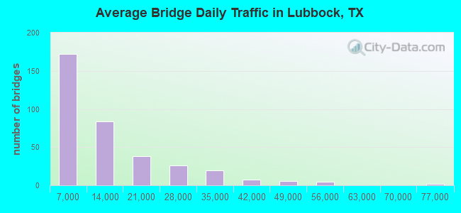
- 4,265,414Total average daily traffic
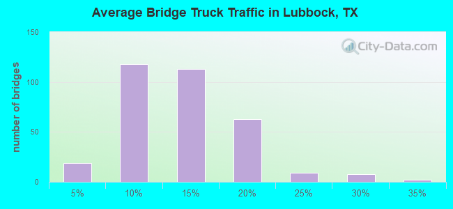
- 451,816Total average daily truck traffic
- National Bridge Inventory (NBI) Registered Bridges for Lubbock
- No street view available for this location
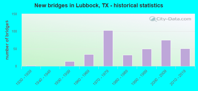
- New bridges - historical statistics
- 21930-1939
- 141950-1959
- 341960-1969
- 1031970-1979
- 321980-1989
- 501990-1999
- 752000-2009
- 512010-2019
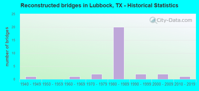
- Reconstructed bridges - Historical Statistics
- 11940-1949
- 01950-1959
- 11960-1969
- 21970-1979
- 201980-1989
- 21990-1999
- 22000-2009
- 12010-2019
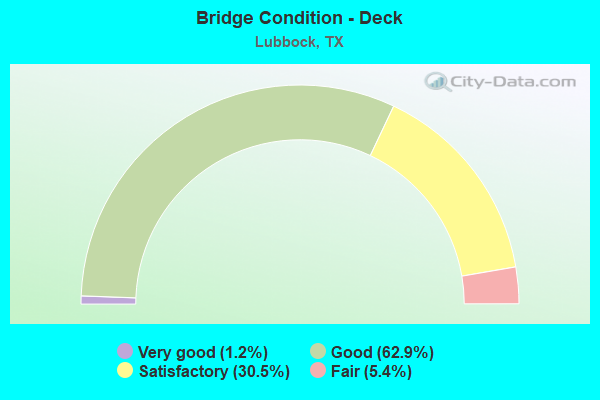
- Bridge Condition - Deck
- 1.2%Very good
- 62.9%Good
- 30.5%Satisfactory
- 5.4%Fair
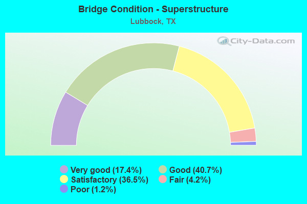
- Bridge Condition - Superstructure
- 17.4%Very good
- 40.7%Good
- 36.5%Satisfactory
- 4.2%Fair
- 1.2%Poor
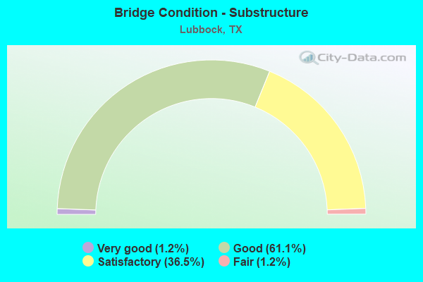
- Bridge Condition - Substructure
- 1.2%Very good
- 61.1%Good
- 36.5%Satisfactory
- 1.2%Fair
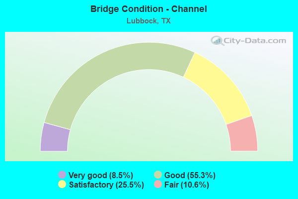
- Bridge Condition - Channel
- 8.5%Very good
- 55.3%Good
- 25.5%Satisfactory
- 10.6%Fair
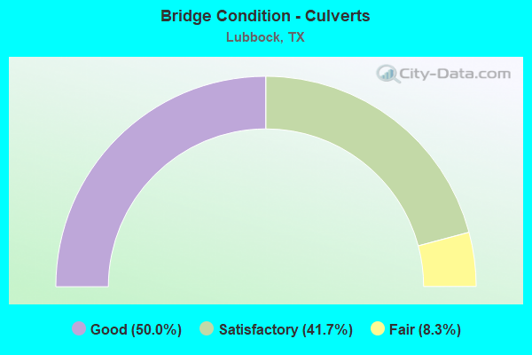
- Bridge Condition - Culverts
- 50.0%Good
- 41.7%Satisfactory
- 8.3%Fair
Find on map >> Show street view
Structure Number: 51520038001048, Location: 0.35 MI SW OF SH 114 (Lat: 33.574500, Lng: -101.905500), Route carried "under" structure: City street , Year Built: 2009, Structure Length: 0. m, Average Daily Traffic: 22,900 (year 2010), Truck Traffic: 5%, Features Intersected: QUAKER AVENUE, Facility Carried by Structure: W-19 OFF RAMP
Minimum Vertical Clearance: 5.59m (18.34ft), Kilometerpoint: 0.000, Lanes on structure: 8, Material/Design: Prestressed concrete, Design/Construction: Stringer/Multi-beam, Length of Maximum Span: 36.3m (119.1ft)
Find on map >> Show street view
Structure Number: 51520038001096, Location: 1.75 MI S OF SH 114 (Lat: 33.552150, Lng: -101.939208), Route carried "under" structure: ServiceUS 62, Year Built: 2006, Structure Length: 0. m, Average Daily Traffic: 10,000 (year 2010), Truck Traffic: 5%, Features Intersected: US 62/82 FR RDS, Facility Carried by Structure: W LP 289 SB
Minimum Vertical Clearance: 7.11m (23.33ft), Kilometerpoint: 17.864, Lanes on structure: 7, Material/Design: Prestressed concrete, Design/Construction: Stringer/Multi-beam, Length of Maximum Span: 33.8m (110.9ft)
Find on map >> Show street view
Structure Number: 51520038001097, Location: 1.75 MI S OF SH 114 (Lat: 33.552319, Lng: -101.938939), Route carried "under" structure: ServiceUS 62, Year Built: 2006, Structure Length: 0. m, Average Daily Traffic: 10,000 (year 2010), Truck Traffic: 5%, Features Intersected: US 62/82 FR RDS, Facility Carried by Structure: W LP 289 NB
Minimum Vertical Clearance: 6.76m (22.18ft), Kilometerpoint: 17.880, Lanes on structure: 8, Material/Design: Prestressed concrete, Design/Construction: Stringer/Multi-beam, Length of Maximum Span: 33.8m (110.9ft)
Find on map >> Show street view
Structure Number: 51520038001102, Location: 1.75 MI S OF SH 114 (Lat: 33.552622, Lng: -101.939539), Route carried "under" structure: ServiceUS 62, Year Built: 2006, Structure Length: 0. m, Average Daily Traffic: 5,000 (year 2015), Truck Traffic: 5%, Features Intersected: US 62/82 EB FRTG RD, Facility Carried by Structure: W LOOP 289 SB OFF
Minimum Vertical Clearance: 5.31m (17.42ft), Kilometerpoint: 17.848, Lanes on structure: 3, Material/Design: Prestressed concrete, Design/Construction: Stringer/Multi-beam, Length of Maximum Span: 33.5m (109.9ft)
Find on map >> Show street view
Structure Number: 51520038001214, Location: 0.20 MI SW OF SLIDE RD (Lat: 33.562300, Lng: -101.925400), Route carried "under" structure: City street , Year Built: 2009, Structure Length: 0. m, Average Daily Traffic: 3,400 (year 2010), Truck Traffic: 5%, Features Intersected: 34TH STREET SPLIT, Facility Carried by Structure: CHIC-E RAMP
Minimum Vertical Clearance: 5.28m (17.32ft), Kilometerpoint: 0.000, Lanes on structure: 3, Material/Design: Prestressed concrete, Design/Construction: Stringer/Multi-beam, Length of Maximum Span: 25.0m (82.0ft)
Find on map >> Show street view
Structure Number: 51520038001215, Location: 0.20 MI SW OF SLIDE RD (Lat: 33.562400, Lng: -101.925500), Route carried "under" structure: City street , Year Built: 2009, Structure Length: 0. m, Average Daily Traffic: 4,200 (year 2010), Truck Traffic: 5%, Features Intersected: 34TH STREET SPLIT, Facility Carried by Structure: US 82 EB
Minimum Vertical Clearance: 5.31m (17.42ft), Kilometerpoint: 0.000, Lanes on structure: 3, Material/Design: Prestressed concrete, Design/Construction: Stringer/Multi-beam, Length of Maximum Span: 25.0m (82.0ft)
Find on map >> Show street view
Structure Number: 51520038001216, Location: 1.20 MI NE OF LOOP 289 (Lat: 33.563925, Lng: -101.922444), Route carried "under" structure: City street , Year Built: 2009, Structure Length: 0. m, Average Daily Traffic: 7,600 (year 2010), Truck Traffic: 5%, Features Intersected: SLIDE ROAD, Facility Carried by Structure: US 82 EB
Minimum Vertical Clearance: 5.69m (18.67ft), Kilometerpoint: 0.000, Lanes on structure: 9, Material/Design: Prestressed concrete, Design/Construction: Stringer/Multi-beam, Length of Maximum Span: 37.8m (124.0ft)
Find on map >> Show street view
Structure Number: 51520038001217, Location: 1.20 MI NE OF LOOP 289 (Lat: 33.564700, Lng: -101.921989), Route carried "under" structure: City street , Year Built: 2009, Structure Length: 0. m, Average Daily Traffic: 7,600 (year 2010), Truck Traffic: 5%, Features Intersected: SLIDE ROAD, Facility Carried by Structure: US 82 WB
Minimum Vertical Clearance: 5.26m (17.26ft), Kilometerpoint: 28.968, Lanes on structure: 9, Material/Design: Prestressed concrete, Design/Construction: Stringer/Multi-beam, Length of Maximum Span: 38.1m (125.0ft)
Find on map >> Show street view
Structure Number: 51520038001218, Location: 0.20 MI SW OF SLIDE RD (Lat: 33.562600, Lng: -101.925800), Route carried "under" structure: City street , Year Built: 2009, Structure Length: 0. m, Average Daily Traffic: 7,600 (year 2010), Truck Traffic: 5%, Features Intersected: 34TH STREET SPLIT, Facility Carried by Structure: US 82 WB
Minimum Vertical Clearance: 5.36m (17.59ft), Kilometerpoint: 0.000, Lanes on structure: 3, Material/Design: Prestressed concrete, Design/Construction: Stringer/Multi-beam, Length of Maximum Span: 25.0m (82.0ft)
Find on map >> Show street view
Structure Number: 51520038001231, Location: 1.25 MI SW OF LOOP 289 (Lat: 33.542800, Lng: -101.957000), Route carried "under" structure: City street , Year Built: 2015, Structure Length: 0. m, Average Daily Traffic: 18,680 (year 2013), Truck Traffic: 10%, Features Intersected: MILWAUKEE AVENUE, Facility Carried by Structure: US 62 EB
Minimum Vertical Clearance: 5.26m (17.26ft), Kilometerpoint: 14.484, Lanes on structure: 9, Material/Design: Prestressed concrete, Design/Construction: Stringer/Multi-beam, Length of Maximum Span: 39.6m (129.9ft)
Find on map >> Show street view
Structure Number: 51520038001232, Location: 1.25 MI SW OF LOOP 289 (Lat: 33.542800, Lng: -101.957100), Route carried "under" structure: City street , Year Built: 2015, Structure Length: 0. m, Average Daily Traffic: 18,000 (year 2013), Truck Traffic: 10%, Features Intersected: MILWAUKEE AVENUE, Facility Carried by Structure: US 62 WB
Minimum Vertical Clearance: 5.31m (17.42ft), Kilometerpoint: 14.484, Lanes on structure: 9, Material/Design: Prestressed concrete, Design/Construction: Stringer/Multi-beam, Length of Maximum Span: 39.6m (129.9ft)
Find on map >> Show street view
Structure Number: 51520038001234, Location: 2.48 MI SW OF LOOP 289 (Lat: 33.532064, Lng: -101.974417), Route carried "under" structure: State highway 1600, Year Built: 2017, Structure Length: 0. m, Features Intersected: FM 1600, Facility Carried by Structure: US 62 / 82
Minimum Vertical Clearance: 5.18m (16.99ft), Kilometerpoint: 29.404, Material/Design: Prestressed concrete, Design/Construction: Stringer/Multi-beam, Length of Maximum Span: 43.3m (142.1ft)
Find on map >> Show street view
Structure Number: 51520038001235, Location: 1.8 Miles W of LP 289 (Lat: 33.538900, Lng: -101.962100), Route carried "under" structure: US 62, Year Built: 2016, Structure Length: 0. m, Average Daily Traffic: 7,010 (year 2013), Truck Traffic: 12%, Features Intersected: US 62/82, Facility Carried by Structure: Spur 327
Minimum Vertical Clearance: 4.65m (15.26ft), Kilometerpoint: 15.249, Lanes on structure: 5, Material/Design: Prestressed concrete, Design/Construction: Stringer/Multi-beam, Length of Maximum Span: 35.4m (116.1ft)
Find on map >> Show street view
Structure Number: 51520038015228, Location: 1.4 MILES EAST OF US62/82 (Lat: 33.539000, Lng: -101.939300), Route carried "under" structure: City street , Year Built: 2009, Structure Length: 0. m, Average Daily Traffic: 19,800 (year 2010), Features Intersected: FRANKFORD AVENUE, Facility Carried by Structure: SPUR 327
Minimum Vertical Clearance: 5.26m (17.26ft), Kilometerpoint: 0.000, Lanes on structure: 8, Material/Design: Prestressed concrete, Design/Construction: Stringer/Multi-beam, Length of Maximum Span: 28.3m (92.8ft)
Find on map >> Show street view
Structure Number: 51520038015233, Location: 1.45 MI W OF LOOP 289 (Lat: 33.538800, Lng: -101.957100), Route carried "under" structure: City street , Year Built: 2014, Structure Length: 0. m, Average Daily Traffic: 15,000 (year 2015), Truck Traffic: 5%, Features Intersected: MILWAUKEE AVENUE, Facility Carried by Structure: SPUR 327
Minimum Vertical Clearance: 5.39m (17.68ft), Kilometerpoint: 14.009, Lanes on structure: 10, Material/Design: Prestressed concrete, Design/Construction: Stringer/Multi-beam, Length of Maximum Span: 36.0m (118.1ft)
Find on map >> Show street view
Structure Number: 5152007830102, Location: 0.90 MI N OF SP 331 (Lat: 33.548900, Lng: -101.788100), Route carried "under" structure: State highway 835, Year Built: 1966, Structure Length: 0. m, Average Daily Traffic: 4,030 (year 2013), Truck Traffic: 12%, Features Intersected: FM 835, Facility Carried by Structure: E LP 289 NB
Minimum Vertical Clearance: 5.26m (17.26ft), Kilometerpoint: 9.516, Lanes on structure: 4, Material/Design: Prestressed concrete, Design/Construction: Stringer/Multi-beam, Length of Maximum Span: 13.7m (44.9ft)
Find on map >> Show street view
Structure Number: 51520078301021, Location: 0.90 MI N OF SP 331 (Lat: 33.548900, Lng: -101.788300), Route carried "under" structure: State highway 835, Year Built: 1966, Structure Length: 0. m, Average Daily Traffic: 3,170 (year 2013), Truck Traffic: 13%, Features Intersected: FM 835, Facility Carried by Structure: E LP 289 SB
Minimum Vertical Clearance: 4.90m (16.08ft), Kilometerpoint: 9.484, Lanes on structure: 4, Material/Design: Prestressed concrete, Design/Construction: Stringer/Multi-beam, Length of Maximum Span: 13.7m (44.9ft)
Find on map >> Show street view
Structure Number: 51520078301039, Location: 0.40 MI S OF US 62 (Lat: 33.592656, Lng: -101.787425), Route carried "under" structure: State highway 40, Year Built: 1970, Structure Length: 0. m, Average Daily Traffic: 4,150 (year 2013), Truck Traffic: 18%, Features Intersected: FM 40, Facility Carried by Structure: E LP 289 NB
Minimum Vertical Clearance: 5.18m (16.99ft), Kilometerpoint: 9.297, Lanes on structure: 2, Material/Design: Prestressed concrete, Design/Construction: Stringer/Multi-beam, Length of Maximum Span: 30.5m (100.1ft)
Find on map >> Show street view
Structure Number: 5152007830104, Location: 0.40 MI S OF US 62 (Lat: 33.592600, Lng: -101.787600), Route carried "under" structure: State highway 40, Year Built: 1970, Structure Length: 0. m, Average Daily Traffic: 2,040 (year 2013), Truck Traffic: 13%, Features Intersected: FM 40, Facility Carried by Structure: E LP 289 SB
Minimum Vertical Clearance: 4.85m (15.91ft), Kilometerpoint: 9.265, Lanes on structure: 2, Material/Design: Prestressed concrete, Design/Construction: Stringer/Multi-beam, Length of Maximum Span: 30.5m (100.1ft)
Find on map >> Show street view
Structure Number: 51520078301042, Location: 0.60 MI SE OF SP 327 (Lat: 33.535300, Lng: -101.922400), Route carried "under" structure: State highway 1730, Year Built: 1971, Structure Length: 0. m, Average Daily Traffic: 37,620 (year 2013), Truck Traffic: 4%, Features Intersected: FM 1730 (SLIDE RD), Facility Carried by Structure: S LP 289 WB
Minimum Vertical Clearance: 4.90m (16.08ft), Kilometerpoint: 0.145, Lanes on structure: 10, Material/Design: Prestressed concrete, Design/Construction: Stringer/Multi-beam, Length of Maximum Span: 36.6m (120.1ft)
Find on map >> Show street view
Structure Number: 51520078301043, Location: 0.60 MI SE OF SP 327 (Lat: 33.535100, Lng: -101.922300), Route carried "under" structure: State highway 1730, Year Built: 1971, Structure Length: 0. m, Average Daily Traffic: 37,620 (year 2013), Truck Traffic: 4%, Features Intersected: FM 1730 (SLIDE RD), Facility Carried by Structure: S LP 289 EB
Minimum Vertical Clearance: 4.80m (15.75ft), Kilometerpoint: 0.164, Lanes on structure: 10, Material/Design: Prestressed concrete, Design/Construction: Stringer/Multi-beam, Length of Maximum Span: 36.6m (120.1ft)
Find on map >> Show street view
Structure Number: 51520078301044, Location: 1.50 MI SE OF SP 327 (Lat: 33.531000, Lng: -101.907000), Route carried "under" structure: City street , Year Built: 1971, Structure Length: 0. m, Average Daily Traffic: 3,000 (year 2010), Truck Traffic: 5%, Features Intersected: QUAKER AVE, Facility Carried by Structure: S LP 289 WB
Minimum Vertical Clearance: 4.83m (15.85ft), Kilometerpoint: 9.382, Lanes on structure: 9, Material/Design: Prestressed concrete, Design/Construction: Stringer/Multi-beam, Length of Maximum Span: 36.6m (120.1ft)
Find on map >> Show street view
Structure Number: 51520078301045, Location: 1.50 MI SE OF SP 327 (Lat: 33.530800, Lng: -101.907000), Route carried "under" structure: City street , Year Built: 1971, Structure Length: 0. m, Average Daily Traffic: 3,000 (year 2010), Truck Traffic: 5%, Features Intersected: QUAKER AVE, Facility Carried by Structure: S LP 289 EB
Minimum Vertical Clearance: 4.83m (15.85ft), Kilometerpoint: 9.382, Lanes on structure: 9, Material/Design: Prestressed concrete, Design/Construction: Stringer/Multi-beam, Length of Maximum Span: 36.6m (120.1ft)
Find on map >> Show street view
Structure Number: 51520078301047, Location: 2.05 MI E OF FM 1730 (Lat: 33.529100, Lng: -101.887600), Route carried "under" structure: City street , Year Built: 1971, Structure Length: 0. m, Average Daily Traffic: 6,000 (year 0001), Truck Traffic: 5%, Features Intersected: INDIANA AVE, Facility Carried by Structure: S LP 289 WB
Minimum Vertical Clearance: 4.85m (15.91ft), Kilometerpoint: 9.093, Lanes on structure: 10, Material/Design: Prestressed concrete, Design/Construction: Stringer/Multi-beam, Length of Maximum Span: 35.1m (115.2ft)
Find on map >> Show street view
Structure Number: 51520078301048, Location: 2.05 MI E OF FM 1730 (Lat: 33.528900, Lng: -101.887600), Route carried "under" structure: City street , Year Built: 1971, Structure Length: 0. m, Average Daily Traffic: 6,000 (year 2010), Truck Traffic: 5%, Features Intersected: INDIANA AVE, Facility Carried by Structure: S LP 289 EB
Minimum Vertical Clearance: 4.95m (16.24ft), Kilometerpoint: 9.093, Lanes on structure: 10, Material/Design: Prestressed concrete, Design/Construction: Stringer/Multi-beam, Length of Maximum Span: 35.1m (115.2ft)
Find on map >> Show street view
Structure Number: 5152007830105, Location: 1.00 MI S OF FM 40 (Lat: 33.578100, Lng: -101.787600), Route carried "under" structure: City street , Year Built: 1972, Structure Length: 0. m, Average Daily Traffic: 2,000 (year 2015), Truck Traffic: 5%, Features Intersected: E 19TH ST, Facility Carried by Structure: E LP 289 SB
Minimum Vertical Clearance: 5.54m (18.18ft), Kilometerpoint: 27.005, Lanes on structure: 5, Material/Design: Prestressed concrete, Design/Construction: Stringer/Multi-beam, Length of Maximum Span: 18.3m (60.0ft)
Find on map >> Show street view
Structure Number: 51520078301051, Location: 1.00 MI S OF FM 40 (Lat: 33.578100, Lng: -101.787300), Route carried "under" structure: City street , Year Built: 1972, Structure Length: 0. m, Average Daily Traffic: 2,000 (year 2015), Truck Traffic: 5%, Features Intersected: E 19TH ST, Facility Carried by Structure: E LP 289 NB
Minimum Vertical Clearance: 5.59m (18.34ft), Kilometerpoint: 26.989, Lanes on structure: 5, Material/Design: Prestressed concrete, Design/Construction: Stringer/Multi-beam, Length of Maximum Span: 18.3m (60.0ft)
Find on map >> Show street view
Structure Number: 51520078301052, Location: 1.15 MI S OF FM 40 (Lat: 33.575500, Lng: -101.787600), Route carried "under" structure: ServiceState highway 289, Year Built: 1972, Structure Length: 0. m, Average Daily Traffic: 200 (year 2010), Truck Traffic: 5%, Features Intersected: ABANDONED RAILROAD
Minimum Vertical Clearance: 6.53m (21.42ft), Kilometerpoint: 4.458, Lanes on structure: 1, Material/Design: Prestressed concrete, Design/Construction: Stringer/Multi-beam, Length of Maximum Span: 22.9m (75.1ft)
Find on map >> Show street view
Structure Number: 51520078301053, Location: 1.15 MI S OF FM 40 (Lat: 33.575611, Lng: -101.787378), Route carried "under" structure: ServiceState highway 289, Year Built: 1972, Structure Length: 0. m, Average Daily Traffic: 200 (year 2015), Truck Traffic: 5%, Features Intersected: ABANDONED RAILROAD
Minimum Vertical Clearance: 6.68m (21.92ft), Kilometerpoint: 4.442, Lanes on structure: 1, Material/Design: Prestressed concrete, Design/Construction: Stringer/Multi-beam, Length of Maximum Span: 22.9m (75.1ft)
Find on map >> Show street view
Structure Number: 51520078301079, Location: 3.20 MI E OF IH 27 (Lat: 33.536400, Lng: -101.791500), Route carried "under" structure: Spur State highway 331, Year Built: 1961, Structure Length: 0. m, Average Daily Traffic: 4,130 (year 2010), Truck Traffic: 13%, Features Intersected: SP 331 & BNSF RR, Facility Carried by Structure: SE LP 289 NB
Minimum Vertical Clearance: 7.14m (23.43ft), Kilometerpoint: 33.935, Lanes on structure: 6, Material/Design: Steel continuous, Design/Construction: Stringer/Multi-beam, Length of Maximum Span: 19.8m (65.0ft)
Find on map >> Show street view
Structure Number: 5152007830108, Location: 3.20 MI E OF IH 27 (Lat: 33.536500, Lng: -101.791700), Route carried "under" structure: Spur State highway 331, Year Built: 1961, Structure Length: 0. m, Average Daily Traffic: 4,130 (year 2010), Truck Traffic: 13%, Features Intersected: SP 331 & BNSF RR, Facility Carried by Structure: SE LP 289 SB
Minimum Vertical Clearance: 7.24m (23.75ft), Kilometerpoint: 33.935, Lanes on structure: 6, Material/Design: Steel continuous, Design/Construction: Stringer/Multi-beam, Length of Maximum Span: 19.8m (65.0ft)
Find on map >> Show street view
Structure Number: 5152007830109, Location: 1.50 MI W OF IH 27 (Lat: 33.529100, Lng: -101.870439), Route carried "under" structure: City street , Year Built: 1992, Structure Length: 0. m, Average Daily Traffic: 6,000 (year 2010), Truck Traffic: 5%, Features Intersected: UNIVERSITY AVE, Facility Carried by Structure: S LP 289 WB
Minimum Vertical Clearance: 5.46m (17.91ft), Kilometerpoint: 10.750, Lanes on structure: 10, Material/Design: Prestressed concrete, Design/Construction: Stringer/Multi-beam, Length of Maximum Span: 19.8m (65.0ft)
Find on map >> Show street view
Structure Number: 51520078301091, Location: 1.50 MI W OF IH 27 (Lat: 33.528900, Lng: -101.870400), Route carried "under" structure: City street , Year Built: 1992, Structure Length: 0. m, Average Daily Traffic: 6,000 (year 2010), Truck Traffic: 5%, Features Intersected: UNIVERSITY AVE, Facility Carried by Structure: S LP 289 EB
Minimum Vertical Clearance: 5.26m (17.26ft), Kilometerpoint: 10.750, Lanes on structure: 10, Material/Design: Prestressed concrete, Design/Construction: Stringer/Multi-beam, Length of Maximum Span: 19.8m (65.0ft)
Find on map >> Show street view
Structure Number: 51520078301094, Location: 0.3 MI S OF US 62 (Lat: 33.548800, Lng: -101.937800), Route carried "under" structure: City street 50, Year Built: 2005, Structure Length: 0. m, Average Daily Traffic: 1,000 (year 2010), Truck Traffic: 5%, Features Intersected: 50TH STREET, Facility Carried by Structure: SW LP 289 SB
Minimum Vertical Clearance: 4.88m (16.01ft), Lanes on structure: 8, Material/Design: Prestressed concrete, Design/Construction: Stringer/Multi-beam, Length of Maximum Span: 35.1m (115.2ft)
Find on map >> Show street view
Structure Number: 51520078301095, Location: 0.3 MI S OF US 62 (Lat: 33.548800, Lng: -101.937400), Route carried "under" structure: City street 50, Year Built: 2005, Structure Length: 0. m, Average Daily Traffic: 1,000 (year 2010), Truck Traffic: 5%, Features Intersected: 50TH STREET, Facility Carried by Structure: SW LP 289 NB
Minimum Vertical Clearance: 4.88m (16.01ft), Lanes on structure: 8, Material/Design: Prestressed concrete, Design/Construction: Stringer/Multi-beam, Length of Maximum Span: 35.1m (115.2ft)
Find on map >> Show street view
Structure Number: 51520078301098, Location: 1.10 MI S OF US 62 (Lat: 33.539236, Lng: -101.932292), Route carried "under" structure: Spur State highway 327, Year Built: 2006, Structure Length: 0. m, Average Daily Traffic: 6,000 (year 2010), Truck Traffic: 5%, Features Intersected: SPUR 327 WB, Facility Carried by Structure: SW LP 289 EB
Minimum Vertical Clearance: 6.10m (20.01ft), Kilometerpoint: 3.299, Lanes on structure: 2, Material/Design: Prestressed concrete, Design/Construction: Stringer/Multi-beam, Length of Maximum Span: 35.1m (115.2ft)
Find on map >> Show street view
Structure Number: 51520078301099, Location: 1.10 MI S OF US 62 (Lat: 33.538633, Lng: -101.930981), Route carried "under" structure: Spur State highway 327, Year Built: 2006, Structure Length: 0. m, Average Daily Traffic: 6,000 (year 2010), Truck Traffic: 5%, Features Intersected: SPUR 327 WB, Facility Carried by Structure: SW LP 289 WB
Minimum Vertical Clearance: 5.84m (19.16ft), Kilometerpoint: 3.299, Lanes on structure: 2, Material/Design: Prestressed concrete, Design/Construction: Stringer/Multi-beam, Length of Maximum Span: 35.1m (115.2ft)
Find on map >> Show street view
Structure Number: 51520078301101, Location: 1.00 MI S OF US 62 (Lat: 33.539392, Lng: -101.933617), Route carried "under" structure: Spur State highway 327, Year Built: 2006, Structure Length: 0. m, Average Daily Traffic: 6,000 (year 2010), Truck Traffic: 5%, Features Intersected: SP 327 WB, Facility Carried by Structure: LOOP 289 EB OFF RP
Minimum Vertical Clearance: 5.59m (18.34ft), Kilometerpoint: 3.219, Lanes on structure: 3, Material/Design: Prestressed concrete, Design/Construction: Stringer/Multi-beam, Length of Maximum Span: 38.4m (126.0ft)
Find on map >> Show street view
Structure Number: 51520078301103, Location: 0.80 MI S OF US 62 (Lat: 33.543383, Lng: -101.935542), Route carried "under" structure: Ramp State highway 289, Year Built: 2006, Structure Length: 0. m, Average Daily Traffic: 3,000 (year 2010), Truck Traffic: 5%, Features Intersected: RAMP EX69R
Minimum Vertical Clearance: 5.66m (18.57ft), Kilometerpoint: 22.885, Lanes on structure: 1, Material/Design: Prestressed concrete, Design/Construction: Stringer/Multi-beam, Length of Maximum Span: 35.1m (115.2ft)
Find on map >> Show street view
Structure Number: 51520078302035, Location: N LP 289 @ FM 1264 (Lat: 33.621400, Lng: -101.870300), Route carried "under" structure: State highway 1264, Year Built: 1967, Structure Length: 0. m, Average Daily Traffic: 8,600 (year 2009), Truck Traffic: 10%, Features Intersected: FM 1264, Facility Carried by Structure: N LP 289 WB
Minimum Vertical Clearance: 4.80m (15.75ft), Kilometerpoint: 24.118, Lanes on structure: 7, Material/Design: Prestressed concrete, Design/Construction: Stringer/Multi-beam, Length of Maximum Span: 18.9m (62.0ft)
Find on map >> Show street view
Structure Number: 51520078302036, Location: N LP 289 @ FM 1264 (Lat: 32.621200, Lng: -101.870300), Route carried "under" structure: State highway 1264, Year Built: 1967, Structure Length: 0. m, Average Daily Traffic: 8,600 (year 2009), Truck Traffic: 10%, Features Intersected: FM 1264, Facility Carried by Structure: N LP 289 EB
Minimum Vertical Clearance: 4.83m (15.85ft), Kilometerpoint: 24.163, Lanes on structure: 7, Material/Design: Prestressed concrete, Design/Construction: Stringer/Multi-beam, Length of Maximum Span: 18.9m (62.0ft)
Find on map >> Show street view
Structure Number: 5152007830206, Location: LOOP 289 @ 34TH STREET (Lat: 33.563400, Lng: -101.943800), Route carried "under" structure: City street , Year Built: 1973, Structure Length: 0. m, Average Daily Traffic: 3,000 (year 2015), Truck Traffic: 5%, Features Intersected: 34TH STREET, Facility Carried by Structure: LOOP 289 SB
Minimum Vertical Clearance: 5.08m (16.67ft), Kilometerpoint: 16.093, Lanes on structure: 8, Material/Design: Prestressed concrete, Design/Construction: Stringer/Multi-beam, Length of Maximum Span: 36.6m (120.1ft)
Find on map >> Show street view
Structure Number: 51520078302061, Location: LOOP 289 @ 34TH STREET (Lat: 33.563400, Lng: -101.943700), Route carried "under" structure: City street , Year Built: 1973, Structure Length: 0. m, Average Daily Traffic: 3,000 (year 2015), Truck Traffic: 5%, Features Intersected: 34TH STREET, Facility Carried by Structure: LOOP 289 NB
Minimum Vertical Clearance: 5.16m (16.93ft), Kilometerpoint: 16.093, Lanes on structure: 8, Material/Design: Prestressed concrete, Design/Construction: Stringer/Multi-beam, Length of Maximum Span: 36.6m (120.1ft)
Find on map >> Show street view
Structure Number: 51520078302062, Location: ASH AVE @ N LP 289 (Lat: 33.616600, Lng: -101.835600), Route carried "under" structure: State highway 289, Year Built: 1974, Structure Length: 0. m, Average Daily Traffic: 19,140 (year 2013), Truck Traffic: 14%, Features Intersected: N LOOP 289, Facility Carried by Structure: ASH AVE
Minimum Vertical Clearance: 5.31m (17.42ft), Kilometerpoint: 54.106, Lanes on structure: 4, Material/Design: Prestressed concrete continuous, Design/Construction: Stringer/Multi-beam, Length of Maximum Span: 24.4m (80.1ft)
Find on map >> Show street view
Structure Number: 51520078302063, Location: 1.4 MI E OF IH 27 (Lat: 33.616400, Lng: -101.818500), Route carried "under" structure: City street , Year Built: 1974, Structure Length: 0. m, Average Daily Traffic: 1,000 (year 2010), Truck Traffic: 10%, Features Intersected: MLK JR. BLVD, Facility Carried by Structure: LP 289 WB
Minimum Vertical Clearance: 5.23m (17.16ft), Kilometerpoint: 0.161, Lanes on structure: 7, Material/Design: Prestressed concrete continuous, Design/Construction: Stringer/Multi-beam, Length of Maximum Span: 36.6m (120.1ft)
Find on map >> Show street view
Structure Number: 51520078302064, Location: 1.4 MI E OF IH 27 (Lat: 33.616000, Lng: -101.818600), Route carried "under" structure: City street , Year Built: 1974, Structure Length: 0. m, Average Daily Traffic: 1,000 (year 2010), Truck Traffic: 10%, Features Intersected: MLK JR. BLVD, Facility Carried by Structure: LP 289 EB
Minimum Vertical Clearance: 5.31m (17.42ft), Kilometerpoint: 0.177, Lanes on structure: 7, Material/Design: Prestressed concrete continuous, Design/Construction: Stringer/Multi-beam, Length of Maximum Span: 36.6m (120.1ft)
Find on map >> Show street view
Structure Number: 51520078302067, Location: 1.42 MI E OF IH 27 (Lat: 33.615000, Lng: -101.814400), Route carried "under" structure: City street , Year Built: 1974, Structure Length: 0. m, Average Daily Traffic: 1,500 (year 2010), Truck Traffic: 10%, Features Intersected: MUNICIPAL DR, Facility Carried by Structure: LP 289 EB
Minimum Vertical Clearance: 7.16m (23.49ft), Kilometerpoint: 1.609, Lanes on structure: 4, Material/Design: Prestressed concrete, Design/Construction: Stringer/Multi-beam, Length of Maximum Span: 24.4m (80.1ft)
Find on map >> Show street view
Structure Number: 51520078302068, Location: 1.42 MI E OF IH 27 (Lat: 33.615000, Lng: -101.814400), Route carried "under" structure: City street , Year Built: 1974, Structure Length: 0. m, Average Daily Traffic: 1,500 (year 2010), Truck Traffic: 10%, Features Intersected: MUNICIPAL DR, Facility Carried by Structure: LP 289 WB
Minimum Vertical Clearance: 6.83m (22.41ft), Kilometerpoint: 1.770, Lanes on structure: 4, Material/Design: Prestressed concrete, Design/Construction: Stringer/Multi-beam, Length of Maximum Span: 24.4m (80.1ft)
Find on map >> Show street view
Structure Number: 51520078302092, Location: 0.55 MI N OF SH 114 (Lat: 33.585100, Lng: -101.940000), Route carried "under" structure: City street , Year Built: 2003, Structure Length: 0. m, Average Daily Traffic: 6,000 (year 2010), Truck Traffic: 5%, Features Intersected: FRANKFORD AVE, Facility Carried by Structure: W LP 289 EB
Minimum Vertical Clearance: 4.98m (16.34ft), Kilometerpoint: 15.401, Lanes on structure: 7, Material/Design: Prestressed concrete, Design/Construction: Stringer/Multi-beam, Length of Maximum Span: 39.9m (130.9ft)
Find on map >> Show street view
Structure Number: 51520078302093, Location: 0.55 MI N OF SH 114 (Lat: 33.585975, Lng: -101.939531), Route carried "under" structure: City street , Year Built: 2003, Structure Length: 0. m, Average Daily Traffic: 6,000 (year 2010), Truck Traffic: 5%, Features Intersected: FRANKFORD AVE, Facility Carried by Structure: W LP 289 WB
Minimum Vertical Clearance: 5.64m (18.50ft), Kilometerpoint: 15.418, Lanes on structure: 7, Material/Design: Prestressed concrete, Design/Construction: Stringer/Multi-beam, Length of Maximum Span: 39.9m (130.9ft)
Find on map >> Show street view
Structure Number: 51520078302104, Location: 1.3 MI NE OF SH 114 (Lat: 33.592500, Lng: -101.929700), Route carried "under" structure: State highway 2255, Year Built: 2010, Structure Length: 0. m, Average Daily Traffic: 24,000 (year 2010), Truck Traffic: 7%, Features Intersected: FM 2255 (4TH ST), Facility Carried by Structure: LP 289 SB
Minimum Vertical Clearance: 5.64m (18.50ft), Kilometerpoint: 8.987, Lanes on structure: 7, Material/Design: Prestressed concrete, Design/Construction: Stringer/Multi-beam, Length of Maximum Span: 29.9m (98.1ft)
Find on map >> Show street view
Structure Number: 51520078302105, Location: 1.3 MI NE OF SH 114 (Lat: 33.592050, Lng: -101.930011), Route carried "under" structure: State highway 2255, Year Built: 2010, Structure Length: 0. m, Average Daily Traffic: 12,500 (year 2010), Truck Traffic: 11%, Features Intersected: FM 2255 (4TH ST), Facility Carried by Structure: LP 289 NB
Minimum Vertical Clearance: 5.51m (18.08ft), Kilometerpoint: 8.962, Lanes on structure: 7, Material/Design: Prestressed concrete, Design/Construction: Stringer/Multi-beam, Length of Maximum Span: 29.9m (98.1ft)
Find on map >> Show street view
Structure Number: 51520078302106, Location: 1.8 MI NE OF SH 114 (Lat: 33.596200, Lng: -101.923800), Route carried "under" structure: City street , Year Built: 2010, Structure Length: 0. m, Average Daily Traffic: 5,000 (year 2010), Truck Traffic: 5%, Features Intersected: SLIDE ROAD, Facility Carried by Structure: LP 289 SB
Minimum Vertical Clearance: 5.16m (16.93ft), Kilometerpoint: 1.609, Lanes on structure: 8, Material/Design: Prestressed concrete, Design/Construction: Stringer/Multi-beam, Length of Maximum Span: 29.3m (96.1ft)
Find on map >> Show street view
Structure Number: 51520078302107, Location: 1.8 MI NE OF SH 114 (Lat: 33.596100, Lng: -101.923700), Route carried "under" structure: City street , Year Built: 2010, Structure Length: 0. m, Average Daily Traffic: 5,000 (year 2010), Truck Traffic: 5%, Features Intersected: SLIDE ROAD, Facility Carried by Structure: LP 289 NB
Minimum Vertical Clearance: 5.31m (17.42ft), Kilometerpoint: 1.609, Lanes on structure: 8, Material/Design: Prestressed concrete, Design/Construction: Stringer/Multi-beam, Length of Maximum Span: 29.3m (96.1ft)
Find on map >> Show street view
Structure Number: 51520078302108, Location: 1.00 MI SW OF US 84 (Lat: 33.608300, Lng: -101.904800), Route carried "under" structure: City street , Year Built: 2013, Structure Length: 0. m, Average Daily Traffic: 3,000 (year 2010), Truck Traffic: 5%, Features Intersected: ERSKINE ST / QUAKER AVE, Facility Carried by Structure: LP 289 SB
Minimum Vertical Clearance: 6.04m (19.82ft), Kilometerpoint: 16.093, Lanes on structure: 14, Material/Design: Prestressed concrete, Design/Construction: Stringer/Multi-beam, Length of Maximum Span: 42.7m (140.1ft)
Find on map >> Show street view
Structure Number: 51520078302109, Location: 1.05 MI SW OF US 84 (Lat: 33.606500, Lng: -101.907000), Route carried "under" structure: City street , Year Built: 2014, Structure Length: 0. m, Average Daily Traffic: 3,000 (year 2010), Truck Traffic: 5%, Features Intersected: ERSKINE ST / QUAKER AVE, Facility Carried by Structure: LOOP 289 NB
Minimum Vertical Clearance: 6.43m (21.10ft), Lanes on structure: 13, Material/Design: Prestressed concrete, Design/Construction: Stringer/Multi-beam, Length of Maximum Span: 42.7m (140.1ft)
Find on map >> Show street view
Structure Number: 51520B00006002, Location: 0.10 MI S OF US 82 (Lat: 33.590700, Lng: -101.845400), Route carried "under" structure: City street 6, Year Built: 1980, Structure Length: 0. m, Average Daily Traffic: 4,000 (year 2013), Truck Traffic: 10%, Features Intersected: TEXAS AVE
Minimum Vertical Clearance: 4.93m (16.17ft), Kilometerpoint: 2.736, Lanes on structure: 3, Material/Design: Prestressed concrete, Design/Construction: Box Beam or Girders - Multiple, Length of Maximum Span: 17.1m (56.1ft)
Structure Number: 51520B00565001, Location: 0.40 MI E OF CEDAR AVE, Route carried "under" structure: City street , Year Built: 1990, Structure Length: 0. m, Average Daily Traffic: 50 (year 2011), Truck Traffic: 2%, Features Intersected: BNSF RR & SOUTHEAST DR, Facility Carried by Structure: E 26 ST
Minimum Vertical Clearance: 7.80m (25.59ft), Kilometerpoint: 0.000, Material/Design: Steel continuous, Design/Construction: Stringer/Multi-beam, Length of Maximum Span: 29.0m (95.1ft)
Minimum Vertical Clearance: 7.80m (25.59ft), Kilometerpoint: 0.000, Material/Design: Steel continuous, Design/Construction: Stringer/Multi-beam, Length of Maximum Span: 29.0m (95.1ft)
Find on map >> Show street view
Structure Number: 51520B00820001, Location: 1.00 MI S OF US 62 (Lat: 33.563000, Lng: -101.818200), Route carried "under" structure: State highway 835, Year Built: 1984, Structure Length: 0. m, Average Daily Traffic: 5,400 (year 2015), Truck Traffic: 8%, Features Intersected: 34TH ST; BNSF, Facility Carried by Structure: MLK JR BLVD
Minimum Vertical Clearance: 7.47m (24.51ft), Kilometerpoint: 17.738, Lanes on structure: 6, Material/Design: Prestressed concrete, Design/Construction: Stringer/Multi-beam, Length of Maximum Span: 34.4m (112.9ft)