Bridge Statistics for Lubbock, Texas (TX)
Condition, Traffic, Stress, Structural Evaluation, Project Costs
- National Bridge Inventory (NBI) Statistics
- 361Number of bridges
- 7,454ft / 2,272mTotal length
- $2,160,000Total costs
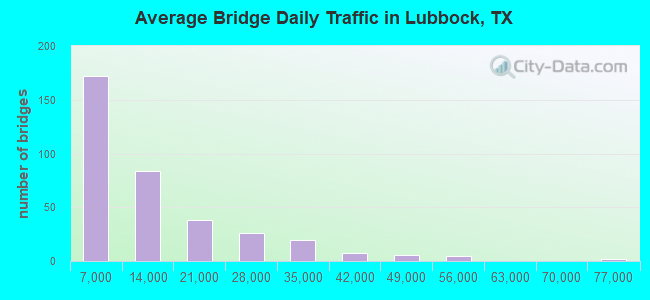
- 4,265,414Total average daily traffic
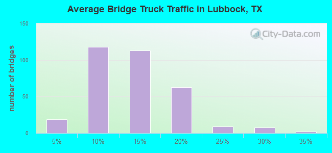
- 451,816Total average daily truck traffic
- National Bridge Inventory (NBI) Registered Bridges for Lubbock
- No street view available for this location
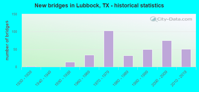
- New bridges - historical statistics
- 21930-1939
- 141950-1959
- 341960-1969
- 1031970-1979
- 321980-1989
- 501990-1999
- 752000-2009
- 512010-2019
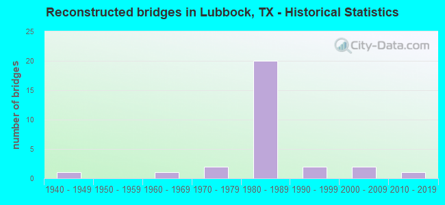
- Reconstructed bridges - Historical Statistics
- 11940-1949
- 01950-1959
- 11960-1969
- 21970-1979
- 201980-1989
- 21990-1999
- 22000-2009
- 12010-2019
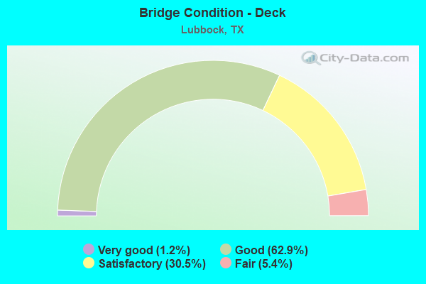
- Bridge Condition - Deck
- 1.2%Very good
- 62.9%Good
- 30.5%Satisfactory
- 5.4%Fair
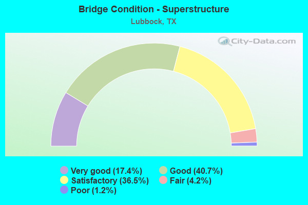
- Bridge Condition - Superstructure
- 17.4%Very good
- 40.7%Good
- 36.5%Satisfactory
- 4.2%Fair
- 1.2%Poor
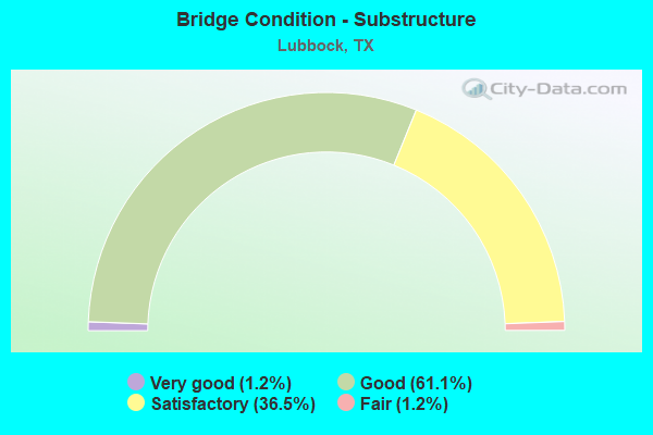
- Bridge Condition - Substructure
- 1.2%Very good
- 61.1%Good
- 36.5%Satisfactory
- 1.2%Fair
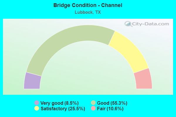
- Bridge Condition - Channel
- 8.5%Very good
- 55.3%Good
- 25.5%Satisfactory
- 10.6%Fair
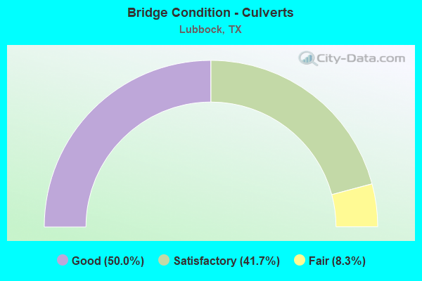
- Bridge Condition - Culverts
- 50.0%Good
- 41.7%Satisfactory
- 8.3%Fair
Find on map >> Show street view
Structure Number: 51520005301186, Location: 0.3 MI WEST OF IH 27 (Lat: 33.592100, Lng: -101.844500), Route carried "under" structure: City street , Year Built: 2013, Structure Length: 0. m, Average Daily Traffic: 1,500 (year 2013), Features Intersected: AVE L;BNSF;BUDDY HOLLY, Facility Carried by Structure: US 82 WB
Minimum Vertical Clearance: 6.61m (21.69ft), Kilometerpoint: 0.000, Lanes on structure: 9, Material/Design: Steel continuous, Design/Construction: Stringer/Multi-beam, Length of Maximum Span: 56.7m (186.0ft)
Find on map >> Show street view
Structure Number: 51520005301187, Location: 0.3 MI WEST OF IH 27 (Lat: 33.592100, Lng: -101.844500), Route carried "under" structure: City street , Year Built: 2013, Structure Length: 0. m, Average Daily Traffic: 1,500 (year 2013), Features Intersected: AVE L; BNSF; BUDDY HOLLY, Facility Carried by Structure: US 82 EB
Minimum Vertical Clearance: 6.61m (21.69ft), Kilometerpoint: 0.000, Lanes on structure: 9, Material/Design: Steel continuous, Design/Construction: Stringer/Multi-beam, Length of Maximum Span: 56.7m (186.0ft)
Find on map >> Show street view
Structure Number: 5152000531803, Location: 2.75 MI SE OF LP 289 (Lat: 33.517900, Lng: -101.773950), Route carried "under" structure: Spur State highway 331, Year Built: 1957, Structure Length: 0. m, Average Daily Traffic: 2,060 (year 2010), Truck Traffic: 13%, Features Intersected: SP 331 SB, Facility Carried by Structure: US 84 WB
Minimum Vertical Clearance: 4.60m (15.09ft), Kilometerpoint: 36.592, Material/Design: Steel continuous, Design/Construction: Stringer/Multi-beam, Length of Maximum Span: 24.4m (80.1ft)
Find on map >> Show street view
Structure Number: 51520005318077, Location: 1.40 MI E OF IH 27 (Lat: 33.529731, Lng: -101.818922), Route carried "under" structure: US 84, Year Built: 1966, Structure Length: 0. m, Average Daily Traffic: 10,690 (year 2013), Truck Traffic: 8%, Features Intersected: US 84, Facility Carried by Structure: SE LP 289 WB
Minimum Vertical Clearance: 4.83m (15.85ft), Kilometerpoint: 10.544, Lanes on structure: 4, Material/Design: Steel continuous, Design/Construction: Stringer/Multi-beam, Length of Maximum Span: 33.5m (109.9ft)
Find on map >> Show street view
Structure Number: 51520005318078, Location: 1.40 MI E OF IH 27 (Lat: 33.529625, Lng: -101.819236), Route carried "under" structure: US 84, Year Built: 1966, Structure Length: 0. m, Average Daily Traffic: 14,000 (year 2013), Truck Traffic: 28%, Features Intersected: US 84, Facility Carried by Structure: SE LP 289 EB
Minimum Vertical Clearance: 4.95m (16.24ft), Kilometerpoint: 10.620, Lanes on structure: 4, Material/Design: Steel continuous, Design/Construction: Stringer/Multi-beam, Length of Maximum Span: 33.5m (109.9ft)
Find on map >> Show street view
Structure Number: 51520006707035, Location: 0.7 MI N OF US 82 (Lat: 33.602561, Lng: -101.853450), Route carried "under" structure: Spur State highway 326, Year Built: 1955, Structure Length: 0. m, Average Daily Traffic: 5,780 (year 2013), Truck Traffic: 7%, Features Intersected: SPUR 326, Facility Carried by Structure: CORNELL ST
Minimum Vertical Clearance: 5.33m (17.49ft), Kilometerpoint: 46.592, Lanes on structure: 6, Material/Design: Steel continuous, Design/Construction: Stringer/Multi-beam, Length of Maximum Span: 28.3m (92.8ft)
Find on map >> Show street view
Structure Number: 51520006707036, Location: 0.3 MI N OF US 82 (Lat: 33.597900, Lng: -101.854400), Route carried "under" structure: City street 1, Year Built: 1955, Structure Length: 0. m, Average Daily Traffic: 200 (year 2010), Features Intersected: FIRST ST/AT&SF RR, Facility Carried by Structure: SP 326 SB
Minimum Vertical Clearance: 7.26m (23.82ft), Kilometerpoint: 0.161, Lanes on structure: 2, Material/Design: Steel continuous, Design/Construction: Stringer/Multi-beam, Length of Maximum Span: 29.3m (96.1ft)
Find on map >> Show street view
Structure Number: 51520006707065, Location: 0.5 MI N OF N LOOP 289 (Lat: 33.624042, Lng: -101.837697), Route carried "under" structure: Ramp Interstate 27, Year Built: 1978, Structure Length: 0. m, Average Daily Traffic: 1,850 (year 2009), Truck Traffic: 20%, Features Intersected: IH 27 SB OFF RAMP
Minimum Vertical Clearance: 5.18m (16.99ft), Kilometerpoint: 17.300, Lanes on structure: 2, Material/Design: Prestressed concrete continuous, Design/Construction: Stringer/Multi-beam, Length of Maximum Span: 30.8m (101.0ft)
Find on map >> Show street view
Structure Number: 51520006707068, Location: 0.5 MI N OF N LOOP 289 (Lat: 33.624103, Lng: -101.836419), Route carried "under" structure: Ramp Interstate 27, Year Built: 1978, Structure Length: 0. m, Average Daily Traffic: 1,850 (year 2009), Truck Traffic: 20%, Features Intersected: IH 27 NB ON RAMP
Minimum Vertical Clearance: 5.21m (17.09ft), Kilometerpoint: 17.260, Lanes on structure: 1, Material/Design: Prestressed concrete continuous, Design/Construction: Stringer/Multi-beam, Length of Maximum Span: 30.8m (101.0ft)
Find on map >> Show street view
Structure Number: 51520006707069, Location: 0.85 MI N OF N LP 289 (Lat: 33.628089, Lng: -101.835519), Route carried "under" structure: Interstate 27, Year Built: 1978, Structure Length: 0. m, Average Daily Traffic: 18,530 (year 2010), Truck Traffic: 20%, Features Intersected: IH 27, Facility Carried by Structure: YUCCA LANE
Minimum Vertical Clearance: 5.26m (17.26ft), Kilometerpoint: 17.809, Lanes on structure: 6, Material/Design: Prestressed concrete continuous, Design/Construction: Stringer/Multi-beam, Length of Maximum Span: 27.4m (89.9ft)
Find on map >> Show street view
Structure Number: 51520006707072, Location: 1.80 MI N OF N LP 289 (Lat: 33.643200, Lng: -101.835500), Route carried "under" structure: State highway 2641, Year Built: 1978, Structure Length: 0. m, Average Daily Traffic: 2,400 (year 2013), Truck Traffic: 7%, Features Intersected: FM 2641 (REGIS ST), Facility Carried by Structure: IH 27 NB
Minimum Vertical Clearance: 5.05m (16.57ft), Kilometerpoint: 23.023, Lanes on structure: 6, Material/Design: Prestressed concrete continuous, Design/Construction: Stringer/Multi-beam, Length of Maximum Span: 35.1m (115.2ft)
Find on map >> Show street view
Structure Number: 51520006707073, Location: 1.80 MI N OF N LP 289 (Lat: 33.643200, Lng: -101.835800), Route carried "under" structure: State highway 2641, Year Built: 1978, Structure Length: 0. m, Average Daily Traffic: 2,400 (year 2013), Truck Traffic: 7%, Features Intersected: FM 2641 (REGIS ST), Facility Carried by Structure: IH 27 SB
Minimum Vertical Clearance: 5.08m (16.67ft), Kilometerpoint: 23.002, Lanes on structure: 6, Material/Design: Prestressed concrete continuous, Design/Construction: Stringer/Multi-beam, Length of Maximum Span: 35.1m (115.2ft)
Find on map >> Show street view
Structure Number: 51520006707075, Location: N LP 289 @ IH 27 ML (Lat: 33.618283, Lng: -101.842094), Route carried "under" structure: Interstate 27, Year Built: 1990, Structure Length: 0. m, Average Daily Traffic: 1,850 (year 2010), Truck Traffic: 20%, Features Intersected: IH 27 ML, Facility Carried by Structure: N LP 289 EB FR
Minimum Vertical Clearance: 5.26m (17.26ft), Kilometerpoint: 16.513, Lanes on structure: 6, Material/Design: Prestressed concrete, Design/Construction: Stringer/Multi-beam, Length of Maximum Span: 24.4m (80.1ft)
Find on map >> Show street view
Structure Number: 51520006707076, Location: N LP 289 @ IH 27 ML (Lat: 33.617669, Lng: -101.842644), Route carried "under" structure: Interstate 27, Year Built: 1990, Structure Length: 0. m, Average Daily Traffic: 2,010 (year 2010), Truck Traffic: 19%, Features Intersected: IH 27 ML, Facility Carried by Structure: N LP 289 WB FR
Minimum Vertical Clearance: 5.23m (17.16ft), Kilometerpoint: 16.423, Lanes on structure: 6, Material/Design: Prestressed concrete, Design/Construction: Stringer/Multi-beam, Length of Maximum Span: 24.4m (80.1ft)
Find on map >> Show street view
Structure Number: 51520006707078, Location: 1.0 MI N OF FM 2641 (Lat: 33.657700, Lng: -101.836300), Route carried "under" structure: City street , Year Built: 1978, Structure Length: 0. m, Average Daily Traffic: 1,000 (year 2010), Truck Traffic: 5%, Features Intersected: E INDEPENDENCE DR, Facility Carried by Structure: IH 27 NB
Minimum Vertical Clearance: 5.11m (16.77ft), Kilometerpoint: 0.161, Lanes on structure: 6, Material/Design: Prestressed concrete continuous, Design/Construction: Stringer/Multi-beam, Length of Maximum Span: 31.4m (103.0ft)
Find on map >> Show street view
Structure Number: 51520006707079, Location: 1.0 MI N OF FM 2641 (Lat: 33.657700, Lng: -101.836300), Route carried "under" structure: City street , Year Built: 1978, Structure Length: 0. m, Average Daily Traffic: 1,000 (year 2010), Truck Traffic: 5%, Features Intersected: E INDEPENDENCE DR, Facility Carried by Structure: IH 27 SB
Minimum Vertical Clearance: 5.11m (16.77ft), Kilometerpoint: 0.177, Lanes on structure: 6, Material/Design: Prestressed concrete continuous, Design/Construction: Stringer/Multi-beam, Length of Maximum Span: 31.4m (103.0ft)
Find on map >> Show street view
Structure Number: 5152000670708, Location: 2.00 MI N OF FM 2641 (Lat: 33.679400, Lng: -101.835800), Route carried "under" structure: County highway 60, Year Built: 1978, Structure Length: 0. m, Average Daily Traffic: 500 (year 2010), Truck Traffic: 5%, Features Intersected: KEUKA ST (CR 60), Facility Carried by Structure: IH 27 NB
Minimum Vertical Clearance: 5.03m (16.50ft), Kilometerpoint: 0.161, Lanes on structure: 4, Material/Design: Prestressed concrete continuous, Design/Construction: Stringer/Multi-beam, Length of Maximum Span: 32.6m (107.0ft)
Find on map >> Show street view
Structure Number: 51520006707081, Location: N LP 289 @ IH 27 (Lat: 33.617900, Lng: -101.842431), Route carried "under" structure: Interstate 27, Year Built: 1990, Structure Length: 0. m, Average Daily Traffic: 20,320 (year 2013), Truck Traffic: 15%, Features Intersected: IH 27 ML & FR, Facility Carried by Structure: N LP 289 WB
Minimum Vertical Clearance: 4.67m (15.32ft), Kilometerpoint: 16.668, Lanes on structure: 2, Material/Design: Prestressed concrete, Design/Construction: Stringer/Multi-beam, Length of Maximum Span: 24.4m (80.1ft)
Find on map >> Show street view
Structure Number: 51520006707082, Location: N LP 289 @ IH 27 (Lat: 33.618053, Lng: -101.842303), Route carried "under" structure: Interstate 27, Year Built: 1990, Structure Length: 0. m, Average Daily Traffic: 20,320 (year 2013), Truck Traffic: 15%, Features Intersected: IH 27 ML & FR, Facility Carried by Structure: N LP 289 EB
Minimum Vertical Clearance: 4.65m (15.26ft), Kilometerpoint: 16.692, Lanes on structure: 2, Material/Design: Prestressed concrete, Design/Construction: Stringer/Multi-beam, Length of Maximum Span: 24.4m (80.1ft)
Find on map >> Show street view
Structure Number: 51520006707083, Location: 2.00 MI N OF FM 2641 (Lat: 33.679400, Lng: -101.835500), Route carried "under" structure: County highway 60, Year Built: 1978, Structure Length: 0. m, Average Daily Traffic: 500 (year 2010), Truck Traffic: 5%, Features Intersected: KEUKA ST (CR 60), Facility Carried by Structure: IH 27 SB
Minimum Vertical Clearance: 5.05m (16.57ft), Kilometerpoint: 0.177, Lanes on structure: 4, Material/Design: Prestressed concrete continuous, Design/Construction: Stringer/Multi-beam, Length of Maximum Span: 32.6m (107.0ft)
Find on map >> Show street view
Structure Number: 51520006707084, Location: 3.0 MI S OF FM 1729 (Lat: 33.694000, Lng: -101.837000), Route carried "under" structure: State highway 1294, Year Built: 1978, Structure Length: 0. m, Average Daily Traffic: 2,200 (year 2010), Truck Traffic: 25%, Features Intersected: FM 1294, Facility Carried by Structure: IH 27 NB
Minimum Vertical Clearance: 5.16m (16.93ft), Kilometerpoint: 31.496, Lanes on structure: 2, Material/Design: Prestressed concrete continuous, Design/Construction: Stringer/Multi-beam, Length of Maximum Span: 36.6m (120.1ft)
Find on map >> Show street view
Structure Number: 51520006707085, Location: 3.0 MI S OF FM 1729 (Lat: 33.694000, Lng: -101.837000), Route carried "under" structure: State highway 1294, Year Built: 1978, Structure Length: 0. m, Average Daily Traffic: 2,200 (year 2010), Truck Traffic: 25%, Features Intersected: FM 1294, Facility Carried by Structure: IH 27 SB
Minimum Vertical Clearance: 5.13m (16.83ft), Kilometerpoint: 31.479, Lanes on structure: 2, Material/Design: Prestressed concrete continuous, Design/Construction: Stringer/Multi-beam, Length of Maximum Span: 36.6m (120.1ft)
Find on map >> Show street view
Structure Number: 51520006707166, Location: 0.5 MI S OF LP 289 (Lat: 33.847000, Lng: -101.847000), Route carried "under" structure: Spur State highway 326, Year Built: 1988, Structure Length: 0. m, Average Daily Traffic: 5,780 (year 2013), Truck Traffic: 7%, Features Intersected: SPUR 326, Facility Carried by Structure: IH 27 SB FR
Minimum Vertical Clearance: 5.16m (16.93ft), Kilometerpoint: 45.255, Lanes on structure: 4, Material/Design: Prestressed concrete, Design/Construction: Stringer/Multi-beam, Length of Maximum Span: 31.7m (104.0ft)
Find on map >> Show street view
Structure Number: 51520006707179, Location: 0.3 MI N OF US 82 (Lat: 33.597900, Lng: -101.854500), Route carried "under" structure: City street 1, Year Built: 1955, Structure Length: 0. m, Average Daily Traffic: 200 (year 2010), Features Intersected: FIRST ST / AT & SF RR, Facility Carried by Structure: SP 326 NB
Minimum Vertical Clearance: 7.19m (23.59ft), Kilometerpoint: 0.177, Lanes on structure: 2, Material/Design: Steel continuous, Design/Construction: Stringer/Multi-beam, Length of Maximum Span: 29.9m (98.1ft)
Find on map >> Show street view
Structure Number: 51520006711167, Location: 0.4 MI S OF LP 289 (Lat: 33.613242, Lng: -101.845767), Route carried "under" structure: Interstate 27, Year Built: 1988, Structure Length: 0. m, Average Daily Traffic: 27,920 (year 2013), Truck Traffic: 13%, Features Intersected: IH 27, Facility Carried by Structure: SP 326 NB
Minimum Vertical Clearance: 5.79m (19.00ft), Kilometerpoint: 13.718, Lanes on structure: 6, Material/Design: Prestressed concrete, Design/Construction: Stringer/Multi-beam, Length of Maximum Span: 40.8m (133.9ft)
Find on map >> Show street view
Structure Number: 51520006711181, Location: 0.55 MI N OF S LP 289 (Lat: 33.538356, Lng: -101.844475), Route carried "under" structure: Interstate 27, Year Built: 1988, Structure Length: 0. m, Average Daily Traffic: 52,830 (year 2013), Truck Traffic: 10%, Features Intersected: IH 27, Facility Carried by Structure: US 84 EB FR
Minimum Vertical Clearance: 5.74m (18.83ft), Kilometerpoint: 5.266, Material/Design: Steel continuous, Design/Construction: Stringer/Multi-beam, Length of Maximum Span: 41.5m (136.2ft)
Find on map >> Show street view
Structure Number: 51520006711182, Location: 0.60 MI N OF S LP 289 (Lat: 33.537231, Lng: -101.843394), Route carried "under" structure: Interstate 27, Year Built: 1988, Structure Length: 0. m, Average Daily Traffic: 52,830 (year 2013), Truck Traffic: 10%, Features Intersected: IH 27, Facility Carried by Structure: US 84 ML
Minimum Vertical Clearance: 7.64m (25.07ft), Kilometerpoint: 5.164, Lanes on structure: 16, Material/Design: Steel continuous, Design/Construction: Stringer/Multi-beam, Length of Maximum Span: 47.9m (157.2ft)
Find on map >> Show street view
Structure Number: 51520006711183, Location: 0.65 MI N OF S LP 289 (Lat: 33.536839, Lng: -101.844453), Route carried "under" structure: Interstate 27, Year Built: 1989, Structure Length: 0. m, Average Daily Traffic: 52,830 (year 2013), Truck Traffic: 10%, Features Intersected: IH 27, Facility Carried by Structure: US 84 WB FR
Minimum Vertical Clearance: 5.59m (18.34ft), Kilometerpoint: 5.086, Material/Design: Steel continuous, Design/Construction: Stringer/Multi-beam, Length of Maximum Span: 38.4m (126.0ft)
Find on map >> Show street view
Structure Number: 51520006711186, Location: 0.20 MI NE OF US 62 (Lat: 33.580300, Lng: -101.838900), Route carried "under" structure: Ramp Interstate 27, Year Built: 1990, Structure Length: 0. m, Average Daily Traffic: 4,000 (year 2010), Truck Traffic: 8%, Features Intersected: IH 27 NB ON-RAMP
Minimum Vertical Clearance: 5.49m (18.01ft), Kilometerpoint: 9.971, Lanes on structure: 1, Material/Design: Prestressed concrete, Design/Construction: Stringer/Multi-beam, Length of Maximum Span: 36.9m (121.1ft)
Find on map >> Show street view
Structure Number: 51520006711187, Location: 0.20 MI NE OF US 62 (Lat: 33.580800, Lng: -101.840200), Route carried "under" structure: Ramp Interstate 27, Year Built: 1990, Structure Length: 0. m, Average Daily Traffic: 4,000 (year 2010), Truck Traffic: 8%, Features Intersected: IH 27 SB OFF-RAMP
Minimum Vertical Clearance: 5.23m (17.16ft), Kilometerpoint: 9.994, Lanes on structure: 1, Material/Design: Prestressed concrete, Design/Construction: Stringer/Multi-beam, Length of Maximum Span: 35.1m (115.2ft)
Find on map >> Show street view
Structure Number: 51520006711188, Location: 0.50 MI N OF US 62 (Lat: 33.584600, Lng: -101.838900), Route carried "under" structure: City street , Year Built: 1990, Structure Length: 0. m, Average Daily Traffic: 5,000 (year 2010), Truck Traffic: 8%, Features Intersected: BNSF RR YARD & BROADWAY, Facility Carried by Structure: IH 27 NB
Minimum Vertical Clearance: 7.62m (25.00ft), Kilometerpoint: 3.267, Lanes on structure: 8, Material/Design: Steel continuous, Design/Construction: Stringer/Multi-beam, Length of Maximum Span: 76.8m (252.0ft)
Find on map >> Show street view
Structure Number: 51520006711189, Location: 0.50 MI N OF US 62 (Lat: 33.584600, Lng: -101.839700), Route carried "under" structure: City street , Year Built: 1990, Structure Length: 0. m, Average Daily Traffic: 5,000 (year 2010), Truck Traffic: 8%, Features Intersected: BNSF RR YARD & BROADWAY, Facility Carried by Structure: IH 27 SB
Minimum Vertical Clearance: 7.62m (25.00ft), Kilometerpoint: 3.251, Lanes on structure: 8, Material/Design: Steel continuous, Design/Construction: Stringer/Multi-beam, Length of Maximum Span: 67.1m (220.1ft)
Find on map >> Show street view
Structure Number: 51520006711192, Location: IH 27 @ MUNICIPAL DR (Lat: 33.598100, Lng: -101.842200), Route carried "under" structure: City street , Year Built: 1990, Structure Length: 0. m, Average Daily Traffic: 5,000 (year 2009), Truck Traffic: 10%, Features Intersected: MUNICIPAL DR / YH DRAW, Facility Carried by Structure: IH 27 NB
Minimum Vertical Clearance: 5.13m (16.83ft), Kilometerpoint: 0.161, Lanes on structure: 6, Material/Design: Prestressed concrete, Design/Construction: Stringer/Multi-beam, Length of Maximum Span: 39.6m (129.9ft)
Find on map >> Show street view
Structure Number: 51520006711193, Location: IH27 @ MUNICIPAL DR (Lat: 33.598600, Lng: -101.842781), Route carried "under" structure: City street , Year Built: 1990, Structure Length: 0. m, Average Daily Traffic: 5,000 (year 2009), Truck Traffic: 10%, Features Intersected: MUNICIPAL DR / YH DRAW, Facility Carried by Structure: IH 27 SB
Minimum Vertical Clearance: 5.13m (16.83ft), Kilometerpoint: 0.177, Lanes on structure: 6, Material/Design: Prestressed concrete, Design/Construction: Stringer/Multi-beam, Length of Maximum Span: 39.0m (128.0ft)
Find on map >> Show street view
Structure Number: 51520006711194, Location: 0.37 MI N OF US 82 (Lat: 33.589700, Lng: -101.841269), Route carried "under" structure: City street , Year Built: 1990, Structure Length: 0. m, Average Daily Traffic: 500 (year 2009), Features Intersected: YH DRAW/ CESAR CHAVEZ DR, Facility Carried by Structure: IH 27 NB FR
Minimum Vertical Clearance: 4.65m (15.26ft), Kilometerpoint: 0.161, Lanes on structure: 2, Material/Design: Prestressed concrete, Design/Construction: Stringer/Multi-beam, Length of Maximum Span: 35.1m (115.2ft)
Find on map >> Show street view
Structure Number: 51520006711195, Location: 0.54 MI N OF US 82 (Lat: 33.599200, Lng: -101.843800), Route carried "under" structure: City street , Year Built: 1990, Structure Length: 0. m, Average Daily Traffic: 500 (year 2009), Features Intersected: YH DRAW/ CESAR CHAVEZ DR, Facility Carried by Structure: IH 27 SB FR
Minimum Vertical Clearance: 4.70m (15.42ft), Kilometerpoint: 0.241, Lanes on structure: 2, Material/Design: Prestressed concrete, Design/Construction: Stringer/Multi-beam, Length of Maximum Span: 27.4m (89.9ft)
Find on map >> Show street view
Structure Number: 51520006711196, Location: MUNICIPAL DR @ CANYON LK (Lat: 33.599100, Lng: -101.842900), Route carried "under" structure: City street , Year Built: 1990, Structure Length: 0. m, Average Daily Traffic: 500 (year 2009), Features Intersected: YH DRAW/ CESAR CHAVEZ DR, Facility Carried by Structure: MUNICIPAL DRIVE
Minimum Vertical Clearance: 4.72m (15.49ft), Kilometerpoint: 0.225, Lanes on structure: 2, Material/Design: Prestressed concrete, Design/Construction: Stringer/Multi-beam, Length of Maximum Span: 30.5m (100.1ft)
Find on map >> Show street view
Structure Number: 51520006711198, Location: 0.75 MI S OF LP 289 (Lat: 33.606853, Lng: -101.845242), Route carried "under" structure: Interstate 27, Year Built: 1990, Structure Length: 0. m, Average Daily Traffic: 27,920 (year 2013), Truck Traffic: 13%, Features Intersected: IH 27, Facility Carried by Structure: ERSKINE ST.
Minimum Vertical Clearance: 5.36m (17.59ft), Kilometerpoint: 13.024, Lanes on structure: 6, Material/Design: Prestressed concrete, Design/Construction: Stringer/Multi-beam, Length of Maximum Span: 28.3m (92.8ft)
Find on map >> Show street view
Structure Number: 515200067112, Location: 0.70 MI N OF US 84 (Lat: 33.548719, Lng: -101.845006), Route carried "under" structure: Interstate 27, Year Built: 1992, Structure Length: 0. m, Average Daily Traffic: 52,830 (year 2013), Truck Traffic: 10%, Features Intersected: IH 27, Facility Carried by Structure: 50TH ST.
Minimum Vertical Clearance: 5.59m (18.34ft), Kilometerpoint: 6.396, Lanes on structure: 7, Material/Design: Prestressed concrete, Design/Construction: Stringer/Multi-beam, Length of Maximum Span: 31.7m (104.0ft)
Find on map >> Show street view
Structure Number: 51520006711201, Location: 0.65 MI E OF US 84 (Lat: 33.556053, Lng: -101.845000), Route carried "under" structure: Interstate 27, Year Built: 1992, Structure Length: 0. m, Average Daily Traffic: 48,140 (year 2013), Truck Traffic: 10%, Features Intersected: IH 27, Facility Carried by Structure: 42ND ST.
Minimum Vertical Clearance: 5.44m (17.85ft), Kilometerpoint: 7.200, Lanes on structure: 3, Lanes under structure: 8, Material/Design: Prestressed concrete, Design/Construction: Stringer/Multi-beam, Length of Maximum Span: 31.7m (104.0ft)
Find on map >> Show street view
Structure Number: 51520006711202, Location: 1.10 MI S OF US 62 (Lat: 33.563300, Lng: -101.845300), Route carried "under" structure: City street , Year Built: 1992, Structure Length: 0. m, Average Daily Traffic: 4,000 (year 2010), Truck Traffic: 8%, Features Intersected: 34TH ST, Facility Carried by Structure: IH 27 SB
Minimum Vertical Clearance: 5.31m (17.42ft), Kilometerpoint: 21.694, Lanes on structure: 7, Material/Design: Prestressed concrete, Design/Construction: Stringer/Multi-beam, Length of Maximum Span: 37.2m (122.0ft)
Find on map >> Show street view
Structure Number: 51520006711203, Location: 1.10 MI S OF US 62 (Lat: 33.563300, Lng: -101.844700), Route carried "under" structure: City street , Year Built: 1992, Structure Length: 0. m, Average Daily Traffic: 4,000 (year 2010), Truck Traffic: 8%, Features Intersected: 34TH ST, Facility Carried by Structure: IH 27 NB
Minimum Vertical Clearance: 5.33m (17.49ft), Kilometerpoint: 21.726, Lanes on structure: 7, Material/Design: Prestressed concrete, Design/Construction: Stringer/Multi-beam, Length of Maximum Span: 37.2m (122.0ft)
Find on map >> Show street view
Structure Number: 51520006711204, Location: 0.40 MI S OF US 62 (Lat: 33.572900, Lng: -101.843700), Route carried "under" structure: ServiceOther road 27, Year Built: 1992, Structure Length: 0. m, Average Daily Traffic: 2,000 (year 2010), Truck Traffic: 5%, Features Intersected: TURNAROUND / CONNECTOR
Minimum Vertical Clearance: 8.05m (26.41ft), Kilometerpoint: 9.045, Lanes on structure: 3, Material/Design: Prestressed concrete, Design/Construction: Stringer/Multi-beam, Length of Maximum Span: 39.6m (129.9ft)
Find on map >> Show street view
Structure Number: 51520006711205, Location: 0.40 MI S OF US 62 (Lat: 33.572400, Lng: -101.843200), Route carried "under" structure: ServiceOther road 27, Year Built: 1992, Structure Length: 0. m, Average Daily Traffic: 2,000 (year 2010), Truck Traffic: 5%, Features Intersected: TURNAROUND / CONNECTOR
Minimum Vertical Clearance: 7.60m (24.93ft), Kilometerpoint: 9.045, Lanes on structure: 3, Material/Design: Prestressed concrete, Design/Construction: Stringer/Multi-beam, Length of Maximum Span: 39.6m (129.9ft)
Find on map >> Show street view
Structure Number: 51520006711206, Location: 0.90 MI S OF US 82 (Lat: 33.577856, Lng: -101.840947), Route carried "under" structure: US 62, Year Built: 1992, Structure Length: 0. m, Average Daily Traffic: 13,400 (year 2011), Truck Traffic: 3%, Features Intersected: US 62 (19TH ST), Facility Carried by Structure: IH 27 SB
Minimum Vertical Clearance: 5.33m (17.49ft), Kilometerpoint: 30.365, Lanes on structure: 9, Material/Design: Prestressed concrete, Design/Construction: Stringer/Multi-beam, Length of Maximum Span: 39.9m (130.9ft)
Find on map >> Show street view
Structure Number: 51520006711207, Location: 0.90 MI S OF US 82 (Lat: 33.577842, Lng: -101.840714), Route carried "under" structure: US 62, Year Built: 1992, Structure Length: 0. m, Average Daily Traffic: 13,400 (year 2011), Truck Traffic: 3%, Features Intersected: US 62 (19TH ST), Facility Carried by Structure: IH 27 NB
Minimum Vertical Clearance: 5.72m (18.77ft), Kilometerpoint: 30.365, Lanes on structure: 9, Material/Design: Prestressed concrete, Design/Construction: Stringer/Multi-beam, Length of Maximum Span: 39.9m (130.9ft)
Find on map >> Show street view
Structure Number: 5152000671121, Location: 0.9 MI N OF US 62 (Lat: 33.590400, Lng: -101.839000), Route carried "under" structure: US 82, Year Built: 2013, Structure Length: 0. m, Average Daily Traffic: 12,830 (year 2013), Truck Traffic: 11%, Features Intersected: US 82, Facility Carried by Structure: IH 27 NB
Minimum Vertical Clearance: 12.17m (39.93ft), Kilometerpoint: 0.000, Lanes on structure: 11, Material/Design: Prestressed concrete, Design/Construction: Stringer/Multi-beam, Length of Maximum Span: 37.5m (123.0ft)
Find on map >> Show street view
Structure Number: 51520006711211, Location: 0.9 MI N OF US 62 (Lat: 33.592500, Lng: -101.839600), Route carried "under" structure: US 82, Year Built: 2013, Structure Length: 0. m, Average Daily Traffic: 12,830 (year 2013), Truck Traffic: 11%, Features Intersected: US 82, Facility Carried by Structure: IH 27 SB
Minimum Vertical Clearance: 11.53m (37.83ft), Kilometerpoint: 0.000, Lanes on structure: 3, Lanes under structure: 11, Material/Design: Prestressed concrete, Design/Construction: Stringer/Multi-beam, Length of Maximum Span: 37.5m (123.0ft)
Find on map >> Show street view
Structure Number: 51520006711212, Location: 0.90 MI E OF US 84 (Lat: 33.591800, Lng: -101.840200), Route carried "under" structure: US 82, Year Built: 2013, Structure Length: 0. m, Average Daily Traffic: 12,830 (year 2013), Truck Traffic: 11%, Features Intersected: US 82, Facility Carried by Structure: IH 27 SB FRTG RD
Minimum Vertical Clearance: 5.36m (17.59ft), Kilometerpoint: 0.000, Lanes on structure: 4, Material/Design: Prestressed concrete, Design/Construction: Stringer/Multi-beam, Length of Maximum Span: 25.6m (84.0ft)
Find on map >> Show street view
Structure Number: 51520006711213, Location: 1.00 MI E OF US 84 (Lat: 33.591114, Lng: -101.838256), Route carried "under" structure: US 82, Year Built: 2013, Structure Length: 0. m, Average Daily Traffic: 12,830 (year 2013), Truck Traffic: 11%, Features Intersected: US 82, Facility Carried by Structure: IH 27 NB FRTG RD
Minimum Vertical Clearance: 5.59m (18.34ft), Kilometerpoint: 0.000, Lanes on structure: 4, Material/Design: Prestressed concrete, Design/Construction: Stringer/Multi-beam, Length of Maximum Span: 25.3m (83.0ft)
Find on map >> Show street view
Structure Number: 51520006801015, Location: 0.65 MI S OF S LP 289 (Lat: 35.519700, Lng: -101.844200), Route carried "under" structure: City street 82, Year Built: 1970, Structure Length: 0. m, Average Daily Traffic: 4,000 (year 2012), Truck Traffic: 5%, Features Intersected: 82ND STREET, Facility Carried by Structure: US 87 SB
Minimum Vertical Clearance: 5.13m (16.83ft), Kilometerpoint: 21.710, Lanes on structure: 6, Material/Design: Prestressed concrete, Design/Construction: Stringer/Multi-beam, Length of Maximum Span: 18.3m (60.0ft)
Find on map >> Show street view
Structure Number: 51520006801016, Location: 0.65 MI S OF S LP 289 (Lat: 33.519700, Lng: -101.843900), Route carried "under" structure: City street 82, Year Built: 1970, Structure Length: 0. m, Average Daily Traffic: 4,000 (year 2012), Truck Traffic: 5%, Features Intersected: 82ND STREET, Facility Carried by Structure: US 87 NB
Minimum Vertical Clearance: 5.18m (16.99ft), Kilometerpoint: 21.742, Lanes on structure: 6, Material/Design: Prestressed concrete, Design/Construction: Stringer/Multi-beam, Length of Maximum Span: 18.3m (60.0ft)
Find on map >> Show street view
Structure Number: 51520006801017, Location: 1.65 MI S OF S LP 289 (Lat: 33.505200, Lng: -101.845100), Route carried "under" structure: City street 98, Year Built: 1970, Structure Length: 0. m, Average Daily Traffic: 3,000 (year 2015), Truck Traffic: 5%, Features Intersected: 98TH STREET, Facility Carried by Structure: US 87 SB
Minimum Vertical Clearance: 5.26m (17.26ft), Kilometerpoint: 14.822, Lanes on structure: 4, Material/Design: Prestressed concrete, Design/Construction: Stringer/Multi-beam, Length of Maximum Span: 15.2m (49.9ft)
Find on map >> Show street view
Structure Number: 51520006801018, Location: 1.65 MI S OF S LP 289 (Lat: 33.505200, Lng: -101.844900), Route carried "under" structure: City street 98, Year Built: 1970, Structure Length: 0. m, Average Daily Traffic: 3,000 (year 2015), Truck Traffic: 5%, Features Intersected: 98TH STREET, Facility Carried by Structure: US 87 NB
Minimum Vertical Clearance: 5.33m (17.49ft), Kilometerpoint: 14.854, Lanes on structure: 4, Material/Design: Prestressed concrete, Design/Construction: Stringer/Multi-beam, Length of Maximum Span: 15.2m (49.9ft)
Find on map >> Show street view
Structure Number: 51520006801019, Location: 2.65 MI S OF S LP 289 (Lat: 33.490800, Lng: -101.845100), Route carried "under" structure: City street 114, Year Built: 1970, Structure Length: 0. m, Average Daily Traffic: 3,000 (year 2015), Truck Traffic: 5%, Features Intersected: 114TH STREET, Facility Carried by Structure: US 87 SB
Minimum Vertical Clearance: 5.08m (16.67ft), Kilometerpoint: 15.224, Lanes on structure: 2, Material/Design: Prestressed concrete, Design/Construction: Stringer/Multi-beam, Length of Maximum Span: 15.2m (49.9ft)
Find on map >> Show street view
Structure Number: 5152000680102, Location: 2.65 MI S OF S LP 289 (Lat: 33.490594, Lng: -101.844639), Route carried "under" structure: City street 114, Year Built: 1970, Structure Length: 0. m, Average Daily Traffic: 3,000 (year 2015), Truck Traffic: 5%, Features Intersected: 114TH STREET, Facility Carried by Structure: US 87 NB
Minimum Vertical Clearance: 5.36m (17.59ft), Kilometerpoint: 15.273, Lanes on structure: 2, Lanes under structure: 2, Material/Design: Prestressed concrete, Design/Construction: Stringer/Multi-beam, Length of Maximum Span: 15.2m (49.9ft)
Find on map >> Show street view
Structure Number: 51520006801021, Location: 3.65 MI S OF S LP 289 (Lat: 33.476300, Lng: -101.844800), Route carried "under" structure: State highway 1585, Year Built: 1970, Structure Length: 0. m, Average Daily Traffic: 7,000 (year 2010), Truck Traffic: 4%, Features Intersected: FM 1585, Facility Carried by Structure: US 87 SB
Minimum Vertical Clearance: 5.26m (17.26ft), Kilometerpoint: 31.368, Lanes on structure: 6, Material/Design: Prestressed concrete, Design/Construction: Stringer/Multi-beam, Length of Maximum Span: 15.2m (49.9ft)
Find on map >> Show street view
Structure Number: 51520006801022, Location: 3.65 MI S OF S LP 289 (Lat: 33.476300, Lng: -101.844600), Route carried "under" structure: State highway 1585, Year Built: 1970, Structure Length: 0. m, Average Daily Traffic: 7,000 (year 2010), Truck Traffic: 4%, Features Intersected: FM 1585, Facility Carried by Structure: US 87 NB
Minimum Vertical Clearance: 5.51m (18.08ft), Kilometerpoint: 31.368, Lanes on structure: 5, Material/Design: Prestressed concrete, Design/Construction: Stringer/Multi-beam, Length of Maximum Span: 15.2m (49.9ft)
Find on map >> Show street view
Structure Number: 51520006801083, Location: 1.4 MI W OF US 84 (Lat: 33.529558, Lng: -101.844439), Route carried "under" structure: Interstate 27, Year Built: 1988, Structure Length: 0. m, Average Daily Traffic: 2,680 (year 2013), Truck Traffic: 11%, Features Intersected: IH 27, Facility Carried by Structure: S LP 289 EBFR
Minimum Vertical Clearance: 5.54m (18.18ft), Kilometerpoint: 36.373, Lanes on structure: 12, Material/Design: Prestressed concrete, Design/Construction: Stringer/Multi-beam, Length of Maximum Span: 35.1m (115.2ft)
Find on map >> Show street view
Structure Number: 51520006801084, Location: 1.4 MI W OF US 84 (Lat: 33.529228, Lng: -101.844417), Route carried "under" structure: Interstate 27, Year Built: 1988, Structure Length: 0. m, Average Daily Traffic: 45,040 (year 2013), Truck Traffic: 11%, Features Intersected: IH 27, Facility Carried by Structure: S LP 289 EBML
Minimum Vertical Clearance: 5.54m (18.18ft), Kilometerpoint: 36.400, Lanes on structure: 2, Material/Design: Prestressed concrete, Design/Construction: Stringer/Multi-beam, Length of Maximum Span: 35.4m (116.1ft)
Find on map >> Show street view
Structure Number: 51520006801085, Location: 1.4 MI W OF US 84 (Lat: 33.529047, Lng: -101.844406), Route carried "under" structure: Interstate 27, Year Built: 1988, Structure Length: 0. m, Average Daily Traffic: 45,040 (year 2013), Truck Traffic: 11%, Features Intersected: IH 27, Facility Carried by Structure: S LP 289 WBML
Minimum Vertical Clearance: 5.49m (18.01ft), Kilometerpoint: 36.421, Lanes on structure: 2, Material/Design: Prestressed concrete, Design/Construction: Stringer/Multi-beam, Length of Maximum Span: 35.4m (116.1ft)
Find on map >> Show street view
Structure Number: 51520006801086, Location: 1.4 MI W OF US 84 (Lat: 33.528808, Lng: -101.844367), Route carried "under" structure: Interstate 27, Year Built: 1988, Structure Length: 0. m, Average Daily Traffic: 45,040 (year 2013), Truck Traffic: 11%, Features Intersected: IH 27, Facility Carried by Structure: S LP 289 WBFR
Minimum Vertical Clearance: 5.56m (18.24ft), Kilometerpoint: 36.448, Lanes on structure: 2, Material/Design: Prestressed concrete, Design/Construction: Stringer/Multi-beam, Length of Maximum Span: 35.4m (116.1ft)
Find on map >> Show street view
Structure Number: 51520006801087, Location: 0.15 MI W OF IH 27 SB (Lat: 33.529800, Lng: -101.847700), Route carried "under" structure: ServiceState highway 289, Year Built: 1988, Structure Length: 0. m, Average Daily Traffic: 9,400 (year 2013), Truck Traffic: 11%, Features Intersected: S LP 289 WBFR, Facility Carried by Structure: IH 27 SBFR CONN
Minimum Vertical Clearance: 5.36m (17.59ft), Kilometerpoint: 14.243, Lanes on structure: 2, Material/Design: Prestressed concrete, Design/Construction: Stringer/Multi-beam, Length of Maximum Span: 36.6m (120.1ft)
Find on map >> Show street view
Structure Number: 51520006801088, Location: 1.5 MI W OF US 84 (Lat: 33.530661, Lng: -101.844236), Route carried "under" structure: Interstate 27, Year Built: 1988, Structure Length: 0. m, Average Daily Traffic: 45,040 (year 2013), Truck Traffic: 11%, Features Intersected: IH 27 & S LP 289, Facility Carried by Structure: S LP 289 EB CONN
Minimum Vertical Clearance: 7.62m (25.00ft), Kilometerpoint: 36.576, Lanes on structure: 16, Material/Design: Steel continuous, Design/Construction: Stringer/Multi-beam, Length of Maximum Span: 78.6m (257.9ft)
Find on map >> Show street view
Structure Number: 51520006801089, Location: 0.20 MI N OF S LP 289 (Lat: 33.531408, Lng: -101.844961), Route carried "under" structure: Ramp Interstate 27, Year Built: 1988, Structure Length: 0. m, Average Daily Traffic: 4,370 (year 2011), Truck Traffic: 8%, Features Intersected: IH 27 SB CONN
Minimum Vertical Clearance: 5.97m (19.59ft), Kilometerpoint: 36.661, Lanes on structure: 2, Material/Design: Steel continuous, Design/Construction: Stringer/Multi-beam, Length of Maximum Span: 49.4m (162.1ft)
Find on map >> Show street view
Structure Number: 5152000680109, Location: 0.20 MI S OF US 84 (Lat: 33.534197, Lng: -101.844486), Route carried "under" structure: Interstate 27, Year Built: 1988, Structure Length: 0. m, Average Daily Traffic: 45,040 (year 2013), Truck Traffic: 11%, Features Intersected: IH 27, Facility Carried by Structure: 66TH ST.
Minimum Vertical Clearance: 5.39m (17.68ft), Kilometerpoint: 36.989, Lanes on structure: 9, Material/Design: Prestressed concrete, Design/Construction: Stringer/Multi-beam, Length of Maximum Span: 36.0m (118.1ft)
Find on map >> Show street view
Structure Number: 51520013005208, Location: SH 114 @ LP 289 (Lat: 33.577400, Lng: -101.943800), Route carried "under" structure: State highway 114, Year Built: 2010, Structure Length: 0. m, Average Daily Traffic: 28,030 (year 2013), Truck Traffic: 5%, Features Intersected: SH 114 (19TH ST), Facility Carried by Structure: LP 289 NB
Minimum Vertical Clearance: 5.23m (17.16ft), Kilometerpoint: 20.788, Lanes on structure: 10, Material/Design: Prestressed concrete, Design/Construction: Stringer/Multi-beam, Length of Maximum Span: 36.9m (121.1ft)
Find on map >> Show street view
Structure Number: 51520013005209, Location: SH 114 @ LP 289 (Lat: 33.578200, Lng: -101.944000), Route carried "under" structure: State highway 114, Year Built: 2010, Structure Length: 0. m, Average Daily Traffic: 28,030 (year 2013), Truck Traffic: 5%, Features Intersected: SH 114 (19TH ST), Facility Carried by Structure: LP 289 SB
Minimum Vertical Clearance: 5.79m (19.00ft), Kilometerpoint: 20.788, Lanes on structure: 10, Material/Design: Prestressed concrete, Design/Construction: Stringer/Multi-beam, Length of Maximum Span: 36.9m (121.1ft)
Find on map >> Show street view
Structure Number: 51520013101011, Location: 0.3 MI SW OF LP 289 (Lat: 33.598614, Lng: -101.794778), Route carried "under" structure: US 82, Year Built: 1970, Structure Length: 0. m, Average Daily Traffic: 1,840 (year 2010), Truck Traffic: 5%, Features Intersected: US 82, Facility Carried by Structure: US 62 WB
Minimum Vertical Clearance: 5.39m (17.68ft), Kilometerpoint: 30.991, Lanes on structure: 5, Material/Design: Prestressed concrete, Design/Construction: Stringer/Multi-beam, Length of Maximum Span: 36.6m (120.1ft)
Find on map >> Show street view
Structure Number: 51520013101012, Location: 0.3 MI SW OF LP 289 (Lat: 33.598378, Lng: -101.794058), Route carried "under" structure: Ramp US 82, Year Built: 1970, Structure Length: 0. m, Average Daily Traffic: 1,840 (year 2010), Truck Traffic: 5%, Features Intersected: US 82 EB OFF RAMP, Facility Carried by Structure: US 62 EB
Minimum Vertical Clearance: 5.18m (16.99ft), Kilometerpoint: 31.062, Lanes on structure: 1, Material/Design: Prestressed concrete, Design/Construction: Stringer/Multi-beam, Length of Maximum Span: 25.9m (85.0ft)
Find on map >> Show street view
Structure Number: 51520013101037, Location: 0.7 MI NW OF FM 40 (Lat: 33.600800, Lng: -101.791300), Route carried "under" structure: US 62, Year Built: 1970, Structure Length: 0. m, Average Daily Traffic: 530 (year 2010), Truck Traffic: 15%, Features Intersected: US 62;82, Facility Carried by Structure: NE LP 289 WB
Minimum Vertical Clearance: 4.75m (15.58ft), Kilometerpoint: 27.903, Lanes on structure: 6, Lanes under structure: 6, Material/Design: Prestressed concrete, Design/Construction: Stringer/Multi-beam, Length of Maximum Span: 22.9m (75.1ft)
Find on map >> Show street view
Structure Number: 51520013101038, Location: 0.7 MI NW OF FM 40 (Lat: 33.600900, Lng: -101.791500), Route carried "under" structure: US 62, Year Built: 1970, Structure Length: 0. m, Average Daily Traffic: 550 (year 2010), Truck Traffic: 4%, Features Intersected: US 62; 82, Facility Carried by Structure: NE LP 289 EB
Minimum Vertical Clearance: 4.75m (15.58ft), Kilometerpoint: 27.890, Lanes on structure: 6, Lanes under structure: 6, Material/Design: Prestressed concrete, Design/Construction: Stringer/Multi-beam, Length of Maximum Span: 23.8m (78.1ft)
Find on map >> Show street view
Structure Number: 51520013101073, Location: 0.7 MI NW OF FM 40 (Lat: 33.601117, Lng: -101.791261), Route carried "under" structure: ServiceState highway 289, Year Built: 1970, Structure Length: 0. m, Average Daily Traffic: 497 (year 2010), Truck Traffic: 25%, Features Intersected: NE LP 289 FR, Facility Carried by Structure: US 62 WB
Minimum Vertical Clearance: 4.98m (16.34ft), Kilometerpoint: 58.870, Lanes on structure: 6, Material/Design: Prestressed concrete, Design/Construction: Stringer/Multi-beam, Length of Maximum Span: 21.3m (69.9ft)
Find on map >> Show street view
Structure Number: 51520013101074, Location: 0.7 MI NW OF FM 40 (Lat: 33.600081, Lng: -101.792031), Route carried "under" structure: ServiceState highway 289, Year Built: 1970, Structure Length: 0. m, Average Daily Traffic: 497 (year 2010), Truck Traffic: 25%, Features Intersected: NE LP 289 FR, Facility Carried by Structure: US 62 EB
Minimum Vertical Clearance: 5.05m (16.57ft), Kilometerpoint: 58.867, Lanes on structure: 6, Material/Design: Prestressed concrete, Design/Construction: Stringer/Multi-beam, Length of Maximum Span: 21.3m (69.9ft)
Find on map >> Show street view
Structure Number: 51520013108075, Location: 0.55 MI EAST OF IH 27 (Lat: 33.590700, Lng: -101.829600), Route carried "under" structure: City street , Year Built: 2013, Structure Length: 0. m, Average Daily Traffic: 450 (year 2013), Features Intersected: MACKENZIE PARK ROAD, Facility Carried by Structure: US 82 EB
Minimum Vertical Clearance: 4.65m (15.26ft), Kilometerpoint: 0.000, Lanes on structure: 2, Material/Design: Prestressed concrete, Design/Construction: Slab, Length of Maximum Span: 16.8m (55.1ft)
Find on map >> Show street view
Structure Number: 51520013108076, Location: 0.55 MI EAST OF IH 27 (Lat: 33.591000, Lng: -101.829300), Route carried "under" structure: City street , Year Built: 2013, Structure Length: 0. m, Average Daily Traffic: 450 (year 2013), Features Intersected: MACKENIZE PARK RD., Facility Carried by Structure: US 82 WB
Minimum Vertical Clearance: 4.65m (15.26ft), Kilometerpoint: 0.000, Lanes on structure: 2, Material/Design: Prestressed concrete, Design/Construction: Slab, Length of Maximum Span: 16.8m (55.1ft)
Find on map >> Show street view
Structure Number: 51520038001002, Location: US82 AT LOOP289 (Lat: 33.550269, Lng: -101.937900), Route carried "under" structure: ServiceState highway 289, Year Built: 2009, Structure Length: 0. m, Average Daily Traffic: 10,000 (year 2010), Truck Traffic: 5%, Features Intersected: LP 289 FR; US 82 FR, Facility Carried by Structure: US 82 EB DIR CONN
Minimum Vertical Clearance: 6.10m (20.01ft), Kilometerpoint: 0.000, Lanes on structure: 5, Material/Design: Steel continuous, Design/Construction: Stringer/Multi-beam, Length of Maximum Span: 44.5m (146.0ft)
Find on map >> Show street view
Structure Number: 5152003800102, Location: US 82 @ LOOP 289 INTER. (Lat: 33.577100, Lng: -101.933800), Route carried "under" structure: US 82, Year Built: 2009, Structure Length: 0. m, Average Daily Traffic: 31,600 (year 2010), Truck Traffic: 15%, Features Intersected: US 82 & 50TH STREET, Facility Carried by Structure: LP 289 SB DIR CONN
Minimum Vertical Clearance: 4.90m (16.08ft), Kilometerpoint: 18.791, Lanes on structure: 27, Material/Design: Steel continuous, Design/Construction: Stringer/Multi-beam, Length of Maximum Span: 66.8m (219.2ft)
Find on map >> Show street view
Structure Number: 51520038001021, Location: 2.8 MI SW OF SH 114 (Lat: 33.551100, Lng: -101.943400), Route carried "under" structure: State highway 289, Year Built: 2009, Structure Length: 0. m, Average Daily Traffic: 10,000 (year 2010), Truck Traffic: 5%, Features Intersected: LOOP 289, Facility Carried by Structure: US 82 EB
Minimum Vertical Clearance: 5.49m (18.01ft), Kilometerpoint: 17.885, Lanes on structure: 16, Material/Design: Steel continuous, Design/Construction: Stringer/Multi-beam, Length of Maximum Span: 54.0m (177.2ft)
Find on map >> Show street view
Structure Number: 51520038001022, Location: 2.8 MI SW OF SH 114 (Lat: 33.554800, Lng: -101.936900), Route carried "under" structure: State highway 289, Year Built: 2009, Structure Length: 0. m, Average Daily Traffic: 10,000 (year 2010), Truck Traffic: 5%, Features Intersected: LOOP 289, Facility Carried by Structure: US 82 WB
Minimum Vertical Clearance: 5.33m (17.49ft), Kilometerpoint: 0.000, Lanes on structure: 16, Material/Design: Steel continuous, Design/Construction: Stringer/Multi-beam, Length of Maximum Span: 51.5m (169.0ft)
Find on map >> Show street view
Structure Number: 51520038001023, Location: 2.80 MI NE OF LOOP 289 (Lat: 33.577669, Lng: -101.901458), Route carried "under" structure: US 82, Year Built: 2009, Structure Length: 0. m, Average Daily Traffic: 22,900 (year 2010), Truck Traffic: 15%, Features Intersected: US 82, Facility Carried by Structure: 19-E RAMP
Minimum Vertical Clearance: 8.31m (27.26ft), Kilometerpoint: 22.035, Lanes on structure: 15, Material/Design: Steel continuous, Design/Construction: Stringer/Multi-beam, Length of Maximum Span: 65.2m (213.9ft)
Find on map >> Show street view
Structure Number: 51520038001024, Location: 0.80 MI W OF IH 27 (Lat: 33.592500, Lng: -101.853900), Route carried "under" structure: Ramp US 82, Year Built: 2009, Structure Length: 0. m, Average Daily Traffic: 5,000 (year 2010), Truck Traffic: 5%, Features Intersected: Q-E RAMP, Facility Carried by Structure: W-L RAMP
Minimum Vertical Clearance: 5.13m (16.83ft), Kilometerpoint: 0.000, Lanes on structure: 1, Material/Design: Prestressed concrete, Design/Construction: Stringer/Multi-beam, Length of Maximum Span: 39.6m (129.9ft)
Find on map >> Show street view
Structure Number: 51520038001025, Location: 0.40 MI SW OF TTU PKWY (Lat: 33.578200, Lng: -101.899400), Route carried "under" structure: US 82, Year Built: 2009, Structure Length: 0. m, Average Daily Traffic: 28,020 (year 2013), Truck Traffic: 8%, Features Intersected: US 82, Facility Carried by Structure: 19-W RAMP CONN
Minimum Vertical Clearance: 7.62m (25.00ft), Kilometerpoint: 21.840, Lanes on structure: 22, Material/Design: Steel continuous, Design/Construction: Stringer/Multi-beam, Length of Maximum Span: 61.0m (200.1ft)
Find on map >> Show street view
Structure Number: 51520038001035, Location: 0.35 MI W OF UNIVERSITY (Lat: 33.592469, Lng: -101.876600), Route carried "under" structure: Ramp State highway 2255, Year Built: 2009, Structure Length: 0. m, Average Daily Traffic: 5,100 (year 2010), Truck Traffic: 5%, Features Intersected: E-4TH RAMP, Facility Carried by Structure: US 82 BOS-W RAMP
Minimum Vertical Clearance: 5.74m (18.83ft), Kilometerpoint: 0.000, Lanes on structure: 1, Material/Design: Prestressed concrete, Design/Construction: Stringer/Multi-beam, Length of Maximum Span: 38.4m (126.0ft)
Find on map >> Show street view
Structure Number: 51520038001036, Location: 0.35 MI SW OF SH 114 (Lat: 33.574500, Lng: -101.905500), Route carried "under" structure: City street , Year Built: 2009, Structure Length: 0. m, Average Daily Traffic: 19,500 (year 2010), Truck Traffic: 5%, Features Intersected: QUAKER AVENUE, Facility Carried by Structure: US 82 EB
Minimum Vertical Clearance: 5.66m (18.57ft), Kilometerpoint: 0.000, Lanes on structure: 8, Material/Design: Prestressed concrete, Design/Construction: Stringer/Multi-beam, Length of Maximum Span: 38.1m (125.0ft)
Find on map >> Show street view
Structure Number: 51520038001037, Location: 0.95 MI W OF IH 27 (Lat: 33.592600, Lng: -101.855700), Route carried "under" structure: City street , Year Built: 2009, Structure Length: 0. m, Average Daily Traffic: 13,400 (year 2010), Truck Traffic: 5%, Features Intersected: AVENUE Q, Facility Carried by Structure: US 82 EB
Minimum Vertical Clearance: 5.46m (17.91ft), Kilometerpoint: 0.000, Lanes on structure: 10, Material/Design: Prestressed concrete, Design/Construction: Stringer/Multi-beam, Length of Maximum Span: 34.1m (111.9ft)
Find on map >> Show street view
Structure Number: 51520038001038, Location: 0.4 MI SW OF UNIVERSITY (Lat: 33.591944, Lng: -101.878300), Route carried "under" structure: US 82, Year Built: 2009, Structure Length: 0. m, Average Daily Traffic: 28,020 (year 2013), Truck Traffic: 8%, Features Intersected: US 82, Facility Carried by Structure: 4TH EAST RAMP
Minimum Vertical Clearance: 7.62m (25.00ft), Kilometerpoint: 0.000, Lanes on structure: 8, Material/Design: Steel continuous, Design/Construction: Stringer/Multi-beam, Length of Maximum Span: 53.3m (174.9ft)
Find on map >> Show street view
Structure Number: 51520038001039, Location: 0.4 MI SW OF UNIVERSITY (Lat: 33.592000, Lng: -101.878300), Route carried "under" structure: US 82, Year Built: 2009, Structure Length: 0. m, Average Daily Traffic: 28,020 (year 2013), Truck Traffic: 8%, Features Intersected: US 82, Facility Carried by Structure: 4TH RED RAMP
Minimum Vertical Clearance: 7.62m (25.00ft), Kilometerpoint: 0.000, Lanes on structure: 8, Material/Design: Steel continuous, Design/Construction: Stringer/Multi-beam, Length of Maximum Span: 47.2m (154.9ft)
Find on map >> Show street view
Structure Number: 5152003800104, Location: 0.9 MI SW OF UNIVERSITY (Lat: 33.587700, Lng: -101.883400), Route carried "under" structure: US 82, Year Built: 2009, Structure Length: 0. m, Average Daily Traffic: 28,020 (year 2013), Truck Traffic: 8%, Features Intersected: US 82, Facility Carried by Structure: 9TH STREET
Minimum Vertical Clearance: 5.44m (17.85ft), Kilometerpoint: 0.000, Lanes on structure: 8, Material/Design: Steel continuous, Design/Construction: Stringer/Multi-beam, Length of Maximum Span: 55.5m (182.1ft)
Find on map >> Show street view
Structure Number: 51520038001042, Location: 2.80 MI NE OF LOOP 289 (Lat: 33.577886, Lng: -101.901156), Route carried "under" structure: US 82, Year Built: 2009, Structure Length: 0. m, Average Daily Traffic: 22,900 (year 2009), Truck Traffic: 5%, Features Intersected: US 82, Facility Carried by Structure: 19TH STREET EB
Minimum Vertical Clearance: 5.97m (19.59ft), Kilometerpoint: 0.000, Lanes on structure: 7, Material/Design: Steel continuous, Design/Construction: Stringer/Multi-beam, Length of Maximum Span: 46.0m (150.9ft)
Find on map >> Show street view
Structure Number: 51520038001043, Location: 0.40 MI NE OF FM 114 (Lat: 33.581361, Lng: -101.893700), Route carried "under" structure: US 82, Year Built: 2009, Structure Length: 0. m, Average Daily Traffic: 28,020 (year 2013), Truck Traffic: 8%, Features Intersected: US 82, Facility Carried by Structure: TTU PARKWAY
Minimum Vertical Clearance: 5.31m (17.42ft), Kilometerpoint: 23.105, Lanes on structure: 6, Material/Design: Prestressed concrete, Design/Construction: Stringer/Multi-beam, Length of Maximum Span: 31.1m (102.0ft)
Find on map >> Show street view
Structure Number: 51520038001044, Location: 0.90 MI W OF US 84 (Lat: 33.592400, Lng: -101.870300), Route carried "under" structure: US 82, Year Built: 2009, Structure Length: 0. m, Average Daily Traffic: 24,740 (year 2013), Truck Traffic: 10%, Features Intersected: US 82, Facility Carried by Structure: UNIVERSITY AVENUE
Minimum Vertical Clearance: 5.39m (17.68ft), Kilometerpoint: 25.667, Lanes on structure: 8, Material/Design: Prestressed concrete, Design/Construction: Stringer/Multi-beam, Length of Maximum Span: 30.8m (101.0ft)
Structure Number: 51520038001045, Location: 2.80 MI NE OF LOOP 289, Route carried "under" structure: US 82, Year Built: 2009, Structure Length: 0. m, Average Daily Traffic: 28,020 (year 2013), Truck Traffic: 8%, Features Intersected: US 82, Facility Carried by Structure: 19TH STREET WB
Minimum Vertical Clearance: 6.17m (20.24ft), Kilometerpoint: 0.000, Lanes on structure: 7, Material/Design: Steel continuous, Design/Construction: Stringer/Multi-beam, Length of Maximum Span: 46.0m (150.9ft)
Minimum Vertical Clearance: 6.17m (20.24ft), Kilometerpoint: 0.000, Lanes on structure: 7, Material/Design: Steel continuous, Design/Construction: Stringer/Multi-beam, Length of Maximum Span: 46.0m (150.9ft)
Find on map >> Show street view
Structure Number: 51520038001046, Location: 0.35 MI SW OF SH 114 (Lat: 33.575500, Lng: -101.904700), Route carried "under" structure: City street , Year Built: 2009, Structure Length: 0. m, Average Daily Traffic: 19,500 (year 2010), Truck Traffic: 5%, Features Intersected: QUAKER AVENUE, Facility Carried by Structure: US 82 WB
Minimum Vertical Clearance: 5.72m (18.77ft), Kilometerpoint: 0.000, Lanes on structure: 8, Material/Design: Prestressed concrete, Design/Construction: Stringer/Multi-beam, Length of Maximum Span: 38.1m (125.0ft)
Find on map >> Show street view
Structure Number: 51520038001047, Location: 0.95 MI W OF IH 27 (Lat: 33.592900, Lng: -101.854800), Route carried "under" structure: City street , Year Built: 2009, Structure Length: 0. m, Average Daily Traffic: 13,400 (year 2010), Truck Traffic: 5%, Features Intersected: AVENUE Q, Facility Carried by Structure: US 82 WB
Minimum Vertical Clearance: 5.44m (17.85ft), Kilometerpoint: 0.000, Lanes on structure: 10, Material/Design: Prestressed concrete, Design/Construction: Stringer/Multi-beam, Length of Maximum Span: 34.1m (111.9ft)