Bridge Statistics for Lewisville, Texas (TX)
Condition, Traffic, Stress, Structural Evaluation, Project Costs
- National Bridge Inventory (NBI) Statistics
- 184Number of bridges
- 7,766ft / 2,367mTotal length
- $645,000Total costs
- 5,802,018Total average daily traffic
- 393,341Total average daily truck traffic
- National Bridge Inventory (NBI) Registered Bridges for Lewisville
- No street view available for this location
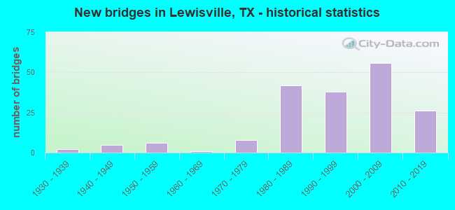
- New bridges - historical statistics
- 21930-1939
- 51940-1949
- 61950-1959
- 11960-1969
- 81970-1979
- 421980-1989
- 381990-1999
- 562000-2009
- 262010-2019
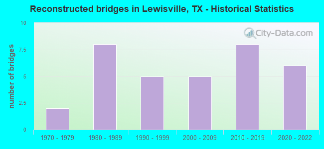
- Reconstructed bridges - Historical Statistics
- 21970-1979
- 81980-1989
- 51990-1999
- 52000-2009
- 82010-2019
- 62020-2022
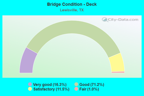
- Bridge Condition - Deck
- 16.3%Very good
- 71.2%Good
- 11.5%Satisfactory
- 1.0%Fair
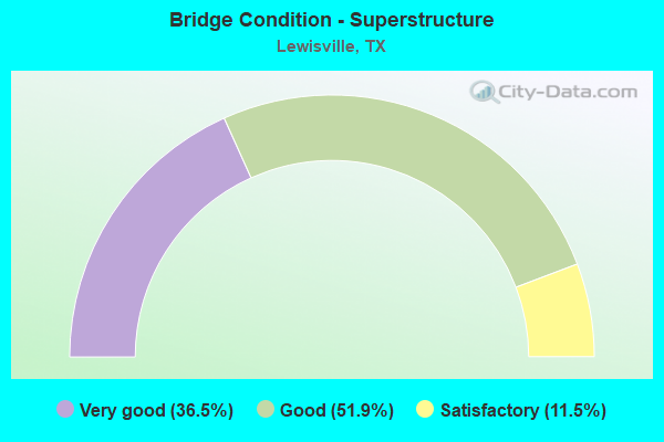
- Bridge Condition - Superstructure
- 36.5%Very good
- 51.9%Good
- 11.5%Satisfactory
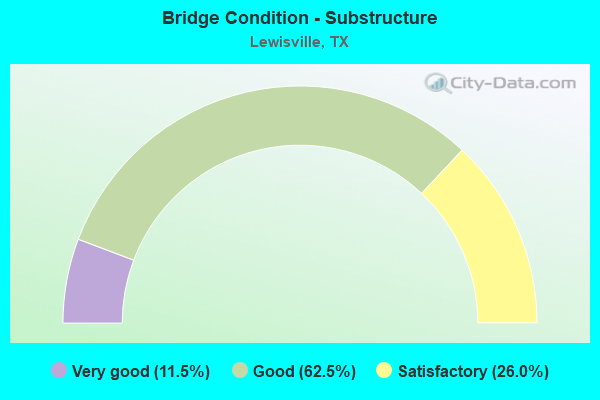
- Bridge Condition - Substructure
- 11.5%Very good
- 62.5%Good
- 26.0%Satisfactory
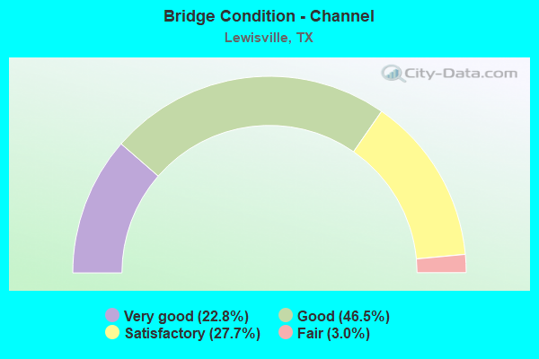
- Bridge Condition - Channel
- 22.8%Very good
- 46.5%Good
- 27.7%Satisfactory
- 3.0%Fair
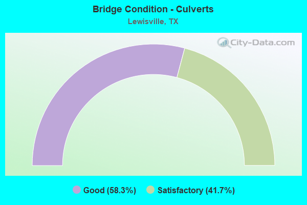
- Bridge Condition - Culverts
- 58.3%Good
- 41.7%Satisfactory
Find on map >> Show street view
Structure Number: 180610C00835002, Location: 0.15 MI N OF VALLEY PKWY (Lat: 33.054747, Lng: -97.023517), Route carried "on" structure: City street , Year Built: 1986, Status: Open, Structure Length: 1.65m (5.41ft), Average Daily Traffic: 8,200 (year 2017), Truck Traffic: 7%, Average Future Daily Traffic: 15,600 (year 2037), Features Intersected: PRAIRIE CREEK, Facility Carried by Structure: OLD ORCHARD LN
Minimum Vertical Clearance: 30+ m (98+ ft), Kilometerpoint: 0.322, Lanes on structure: 4, Owner: City or Municipal Highway Agency, Approaching Roadway Width: 14.6m (47.9ft), Material/Design: Concrete, Design/Construction: Culvert, Number Of Spans In Main Unit: 5, Length of Maximum Span: 3.0m (9.8ft), Curb or Sidewalk Widths: Left: 1.2m (3.9ft), Right: 1.2m (3.9ft)
Condition: Channel: Good, Culverts: Satisfactory, Operating Rating: 32.7 metric tons, Method Used To Determine Operating Rating: Field evaluation and documented engineering judgment, Inventory Rating: 24.5 metric tons, Method Used To Determine Inventory Rating: Field evaluation and documented engineering judgment, Structural Evaluation: Equal to present minimum criteria, Waterway Adequacy: Equal to present minimum criteria, Approach Roadway Alignment: Better than present minimum criteria, Designated Inspection Frequency: Every 24 months, Inspection Date: December 2020
Find on map >> Show street view
Structure Number: 180610C00837001, Location: 0.15 M S OF VALLEY RIDGE (Lat: 33.053906, Lng: -97.019017), Route carried "on" structure: City street , Year Built: 1986, Status: Open, Structure Length: 1.71m (5.61ft), Average Daily Traffic: 5,300 (year 2017), Average Future Daily Traffic: 8,800 (year 2037), Features Intersected: PRAIRIE CREEK, Facility Carried by Structure: N SUMMIT AVE
Minimum Vertical Clearance: 30+ m (98+ ft), Kilometerpoint: 0.241, Lanes on structure: 4, Owner: City or Municipal Highway Agency, Approaching Roadway Width: 14.6m (47.9ft), Skew: 21 degrees, Material/Design: Concrete, Design/Construction: Culvert, Number Of Spans In Main Unit: 5, Length of Maximum Span: 3.0m (9.8ft), Curb or Sidewalk Widths: Left: 1.5m (4.9ft), Right: 1.2m (3.9ft)
Condition: Channel: Good, Culverts: Satisfactory, Operating Rating: 32.7 metric tons, Method Used To Determine Operating Rating: Field evaluation and documented engineering judgment, Inventory Rating: 24.5 metric tons, Method Used To Determine Inventory Rating: Field evaluation and documented engineering judgment, Structural Evaluation: Equal to present minimum criteria, Waterway Adequacy: Equal to present minimum criteria, Approach Roadway Alignment: Equal to present desirable criteria, Designated Inspection Frequency: Every 24 months, Inspection Date: December 2020
Find on map >> Show street view
Structure Number: 180610C00987001, Location: 0.2 Mi N of IH 35E NB FR (Lat: 33.004747, Lng: -96.960811), Route carried "on" structure: City street , Year Built: 2015, Status: Open, Structure Length: 10.73m (35.20ft), Average Daily Traffic: 500 (year 2020), Average Future Daily Traffic: 750 (year 2040), Design Load: HL 93, Features Intersected: Timber Creek, Facility Carried by Structure: Arthurs Ln
Minimum Vertical Clearance: 30+ m (98+ ft), Kilometerpoint: 0.322, Lanes on structure: 2, Owner: City or Municipal Highway Agency, Approaching Roadway Width: 10.4m (34.1ft), Material/Design: Prestressed concrete, Design/Construction: Stringer/Multi-beam, Number Of Spans In Main Unit: 4, Length of Maximum Span: 26.8m (87.9ft), Curb or Sidewalk Widths: Left: 1.5m (4.9ft), Right: 1.5m (4.9ft), Curb-To-Curb Width: 9.2m (30.2ft), Out-to-Out Width: 14.8m (48.6ft)
Condition: Deck: Good, Superstructure: Very good, Substructure: Good, Channel: Good, Operating Rating: 54.4 metric tons, Method Used To Determine Operating Rating: Assigned ratings based on Load and Resistance Factor Design (LRFD) reported in metric tons, Inventory Rating: 32.7 metric tons, Method Used To Determine Inventory Rating: Assigned ratings based on Load and Resistance Factor Design (LRFD) reported in metric tons, Structural Evaluation: Better than present minimum criteria, Deck Geometry: Equal to present minimum criteria, Waterway Adequacy: Superior to present desirable criteria, Approach Roadway Alignment: Equal to present desirable criteria, Designated Inspection Frequency: Every 24 months, Inspection Date: October 2020, Deck Structure Type: Concrete Cast-file-Place, Wearing Surface/Protective System: Wearing Surface: Monolithic Concrete, Deck Protection: Epoxy Coated Reinforcing
Find on map >> Show street view
Structure Number: 180610C00997001, Location: 0.05 MI E OF IH 35E NBFR (Lat: 33.009067, Lng: -96.969792), Route carried "on" structure: City street , Year Built: 1986, Year Reconstructed: 1997, Status: Open, Structure Length: 9.14m (29.99ft), Average Daily Traffic: 15,965 (year 2017), Average Future Daily Traffic: 19,500 (year 2037), Design Load: HS 20, Features Intersected: TIMBER CREEK, Facility Carried by Structure: HEBRON PKWY
Minimum Vertical Clearance: 30+ m (98+ ft), Kilometerpoint: 0.161, Lanes on structure: 7, Owner: City or Municipal Highway Agency, Approaching Roadway Width: 21.9m (71.9ft), Skew: 32 degrees, Material/Design: Prestressed concrete, Design/Construction: Stringer/Multi-beam, Number Of Spans In Main Unit: 3, Length of Maximum Span: 30.5m (100.1ft), Curb or Sidewalk Widths: Left: 1.6m (5.2ft), Right: 1.6m (5.2ft), Curb-To-Curb Width: 27.4m (89.9ft), Out-to-Out Width: 32.8m (107.6ft)
Condition: Deck: Good, Superstructure: Good, Substructure: Satisfactory, Channel: Good, Operating Rating: 54.4 metric tons, Method Used To Determine Operating Rating: Assigned rating based on Load Factor Design (LFD) reported in metric tons, Inventory Rating: 32.7 metric tons, Method Used To Determine Inventory Rating: Assigned rating based on Load Factor Design (LFD) reported in metric tons, Structural Evaluation: Equal to present minimum criteria, Deck Geometry: Somewhat better than minimum adequacy, Waterway Adequacy: Superior to present desirable criteria, Approach Roadway Alignment: Equal to present desirable criteria, Length Of Structure Improvement: 9.11m (29.89ft), Designated Inspection Frequency: Every 24 months, Inspection Date: November 2020, Bridge Improvement Cost: $224,000, Roadway Improvement Cost: $56,000, Total Project Cost: $280,000, Deck Structure Type: Concrete Cast-file-Place
Find on map >> Show street view
Structure Number: 180610C00997003, Location: 0.55 MI E OF IH 35E (Lat: 33.011972, Lng: -96.965211), Route carried "on" structure: City street , Year Built: 1986, Status: Open, Structure Length: 1.65m (5.41ft), Average Daily Traffic: 24,143 (year 2017), Average Future Daily Traffic: 44,255 (year 2037), Features Intersected: TRIB OF TIMBER CR, Facility Carried by Structure: HEBRON PKWY
Minimum Vertical Clearance: 30+ m (98+ ft), Kilometerpoint: 0.966, Lanes on structure: 6, Owner: City or Municipal Highway Agency, Approaching Roadway Width: 21.9m (71.9ft), Skew: 20 degrees, Material/Design: Concrete, Design/Construction: Culvert, Number Of Spans In Main Unit: 5, Length of Maximum Span: 3.0m (9.8ft), Curb or Sidewalk Widths: Left: 1.5m (4.9ft), Right: 1.5m (4.9ft)
Condition: Channel: Good, Culverts: Satisfactory, Operating Rating: 32.7 metric tons, Method Used To Determine Operating Rating: Field evaluation and documented engineering judgment, Inventory Rating: 24.5 metric tons, Method Used To Determine Inventory Rating: Field evaluation and documented engineering judgment, Structural Evaluation: Equal to present minimum criteria, Waterway Adequacy: Superior to present desirable criteria, Approach Roadway Alignment: Equal to present desirable criteria, Designated Inspection Frequency: Every 24 months, Underwater Inspection Frequency: Every 60 months, Inspection Date: November 2020, Underwater Inspection Date: August 2021
Find on map >> Show street view
Structure Number: 180610C01083001, Location: 0.25 MI N OF FM 1171 (Lat: 33.047717, Lng: -97.016058), Route carried "on" structure: City street , Year Built: 1996, Status: Open, Structure Length: 0.82m (2.69ft), Average Daily Traffic: 5,150 (year 2017), Average Future Daily Traffic: 8,500 (year 2037), Features Intersected: TRIB OF PRAIRIE CR, Facility Carried by Structure: N SUMMIT AVE
Minimum Vertical Clearance: 30+ m (98+ ft), Kilometerpoint: 0.451, Lanes on structure: 4, Owner: City or Municipal Highway Agency, Approaching Roadway Width: 14.6m (47.9ft), Skew: 20 degrees, Material/Design: Concrete, Design/Construction: Culvert, Number Of Spans In Main Unit: 3, Length of Maximum Span: 2.4m (7.9ft), Curb or Sidewalk Widths: Left: 1.5m (4.9ft), Right: 1.2m (3.9ft)
Condition: Channel: Good, Culverts: Satisfactory, Operating Rating: 32.7 metric tons, Method Used To Determine Operating Rating: Field evaluation and documented engineering judgment, Inventory Rating: 24.5 metric tons, Method Used To Determine Inventory Rating: Field evaluation and documented engineering judgment, Structural Evaluation: Equal to present minimum criteria, Waterway Adequacy: Superior to present desirable criteria, Approach Roadway Alignment: Equal to present desirable criteria, Designated Inspection Frequency: Every 24 months, Inspection Date: December 2020
Find on map >> Show street view
Structure Number: 180610C01165001, Location: 1.20 MI N OF FM 1171 (Lat: 33.053753, Lng: -97.028039), Route carried "on" structure: City street , Year Built: 1979, Year Reconstructed: 1986, Status: Open, Structure Length: 1.31m (4.30ft), Average Daily Traffic: 9,670 (year 2017), Average Future Daily Traffic: 17,728 (year 2037), Features Intersected: PRAIRIE CREEK, Facility Carried by Structure: N VALLEY PKWY
Minimum Vertical Clearance: 30+ m (98+ ft), Kilometerpoint: 1.915, Lanes on structure: 4, Owner: City or Municipal Highway Agency, Approaching Roadway Width: 14.0m (45.9ft), Skew: 20 degrees, Material/Design: Concrete, Design/Construction: Culvert, Number Of Spans In Main Unit: 4, Length of Maximum Span: 3.0m (9.8ft), Curb or Sidewalk Widths: Left: 1.7m (5.6ft), Right: 2.4m (7.9ft)
Condition: Channel: Good, Culverts: Satisfactory, Operating Rating: 32.7 metric tons, Method Used To Determine Operating Rating: Field evaluation and documented engineering judgment, Inventory Rating: 24.5 metric tons, Method Used To Determine Inventory Rating: Field evaluation and documented engineering judgment, Structural Evaluation: Equal to present minimum criteria, Waterway Adequacy: Equal to present minimum criteria, Approach Roadway Alignment: Equal to present desirable criteria, Length Of Structure Improvement: 1.31m (4.30ft), Designated Inspection Frequency: Every 24 months, Inspection Date: December 2020, Bridge Improvement Cost: $40,000, Roadway Improvement Cost: $10,000, Total Project Cost: $50,000
Find on map >> Show street view
Structure Number: 180610C01165002, Location: 1.35 MI S OF FM 1171 (Lat: 33.022667, Lng: -97.019308), Route carried "on" structure: City street , Year Built: 1984, Year Reconstructed: 2002, Status: Open, Structure Length: 3.81m (12.50ft), Average Daily Traffic: 4,910 (year 2017), Truck Traffic: 7%, Average Future Daily Traffic: 9,006 (year 2037), Design Load: HS 20, Features Intersected: TIMBER CREEK, Facility Carried by Structure: S VALLEY PKWY SB
Minimum Vertical Clearance: 30+ m (98+ ft), Kilometerpoint: 5.794, Lanes on structure: 2, Owner: City or Municipal Highway Agency, Approaching Roadway Width: 7.3m (24.0ft), Material/Design: Concrete continuous, Design/Construction: Slab, Number Of Spans In Main Unit: 5, Length of Maximum Span: 7.6m (24.9ft), Curb or Sidewalk Widths: Left: 1.6m (5.2ft), Right: 0.0m, Curb-To-Curb Width: 7.3m (24.0ft), Out-to-Out Width: 10.3m (33.8ft)
Condition: Deck: Good, Superstructure: Good, Substructure: Satisfactory, Channel: Fair, Operating Rating: 49.9 metric tons, Method Used To Determine Operating Rating: Load Factor (LF), Inventory Rating: 29.9 metric tons, Method Used To Determine Inventory Rating: Load Factor (LF), Structural Evaluation: Equal to present minimum criteria, Deck Geometry: High priority of replacement, Waterway Adequacy: Superior to present desirable criteria, Approach Roadway Alignment: Equal to present desirable criteria, Length Of Structure Improvement: 3.81m (12.50ft), Designated Inspection Frequency: Every 24 months, Inspection Date: November 2020, Deck Structure Type: Concrete Cast-file-Place
Find on map >> Show street view
Structure Number: 180610C01165003, Location: 1.35 MI S OF FM 1171 (Lat: 33.022667, Lng: -97.019233), Route carried "on" structure: City street , Year Built: 1984, Year Reconstructed: 2002, Status: Open, Structure Length: 3.81m (12.50ft), Average Daily Traffic: 4,913 (year 2017), Truck Traffic: 7%, Average Future Daily Traffic: 9,006 (year 2037), Design Load: HS 20, Features Intersected: TIMBER CREEK, Facility Carried by Structure: S VALLEY PKWY NB
Minimum Vertical Clearance: 30+ m (98+ ft), Kilometerpoint: 5.794, Lanes on structure: 2, Owner: City or Municipal Highway Agency, Approaching Roadway Width: 7.3m (24.0ft), Material/Design: Concrete continuous, Design/Construction: Slab, Number Of Spans In Main Unit: 5, Length of Maximum Span: 7.6m (24.9ft), Curb or Sidewalk Widths: Left: 0.0m, Right: 1.6m (5.2ft), Curb-To-Curb Width: 7.3m (24.0ft), Out-to-Out Width: 10.3m (33.8ft)
Condition: Deck: Good, Superstructure: Good, Substructure: Satisfactory, Channel: Satisfactory, Operating Rating: 49.9 metric tons, Method Used To Determine Operating Rating: Load Factor (LF), Inventory Rating: 29.9 metric tons, Method Used To Determine Inventory Rating: Load Factor (LF), Structural Evaluation: Equal to present minimum criteria, Deck Geometry: High priority of replacement, Waterway Adequacy: Superior to present desirable criteria, Approach Roadway Alignment: Equal to present desirable criteria, Length Of Structure Improvement: 3.81m (12.50ft), Designated Inspection Frequency: Every 24 months, Inspection Date: November 2020, Deck Structure Type: Concrete Cast-file-Place
Find on map >> Show street view
Structure Number: 180610C01171001, Location: 0.80 MI W OF MACARTHUR BL (Lat: 32.987136, Lng: -96.985361), Route carried "on" structure: ServiceOther road 121, Year Built: 1989, Status: Open, Structure Length: 1.65m (5.41ft), Average Daily Traffic: 2,500 (year 2013), Truck Traffic: 7%, Average Future Daily Traffic: 3,500 (year 2033), Design Load: HS 20, Features Intersected: TRIB OF DENTON CR
Minimum Vertical Clearance: 30+ m (98+ ft), Kilometerpoint: 1.287, Lanes on structure: 3, Owner: Local Toll Authority, Approaching Roadway Width: 11.0m (36.1ft), Material/Design: Prestressed concrete, Design/Construction: Stringer/Multi-beam, Number Of Spans In Main Unit: 1, Length of Maximum Span: 16.5m (54.1ft), Curb or Sidewalk Widths: Left: 1.9m (6.2ft), Right: 0.0m, Curb-To-Curb Width: 11.0m (36.1ft), Out-to-Out Width: 14.0m (45.9ft)
Condition: Deck: Good, Superstructure: Good, Substructure: Satisfactory, Channel: Good, Operating Rating: 54.4 metric tons, Method Used To Determine Operating Rating: Assigned rating based on Load Factor Design (LFD) reported in metric tons, Inventory Rating: 32.7 metric tons, Method Used To Determine Inventory Rating: Assigned rating based on Load Factor Design (LFD) reported in metric tons, Structural Evaluation: Equal to present minimum criteria, Deck Geometry: High priority of replacement, Waterway Adequacy: Superior to present desirable criteria, Approach Roadway Alignment: Equal to present desirable criteria, Designated Inspection Frequency: Every 24 months, Inspection Date: November 2020, Deck Structure Type: Concrete Cast-file-Place
Find on map >> Show street view
Structure Number: 180610C01171002, Location: 0.80 MI W OF MACARTHUR BL (Lat: 32.986031, Lng: -96.985475), Route carried "on" structure: ServiceOther road 121, Year Built: 1989, Status: Open, Structure Length: 2.65m (8.69ft), Average Daily Traffic: 2,500 (year 2013), Truck Traffic: 7%, Average Future Daily Traffic: 3,500 (year 2033), Design Load: HS 20, Features Intersected: TRIB OF DENTON CR
Minimum Vertical Clearance: 30+ m (98+ ft), Kilometerpoint: 1.287, Lanes on structure: 3, Owner: Local Toll Authority, Approaching Roadway Width: 11.0m (36.1ft), Skew: 3 degrees, Material/Design: Prestressed concrete, Design/Construction: Stringer/Multi-beam, Number Of Spans In Main Unit: 1, Length of Maximum Span: 26.5m (86.9ft), Curb or Sidewalk Widths: Left: 0.0m, Right: 1.9m (6.2ft), Curb-To-Curb Width: 11.0m (36.1ft), Out-to-Out Width: 14.0m (45.9ft)
Condition: Deck: Good, Superstructure: Satisfactory, Substructure: Satisfactory, Channel: Good, Operating Rating: 54.4 metric tons, Method Used To Determine Operating Rating: Assigned rating based on Load Factor Design (LFD) reported in metric tons, Inventory Rating: 32.7 metric tons, Method Used To Determine Inventory Rating: Assigned rating based on Load Factor Design (LFD) reported in metric tons, Structural Evaluation: Equal to present minimum criteria, Deck Geometry: High priority of replacement, Waterway Adequacy: Superior to present desirable criteria, Approach Roadway Alignment: Equal to present desirable criteria, Length Of Structure Improvement: 2.65m (8.69ft), Designated Inspection Frequency: Every 24 months, Inspection Date: November 2020, Bridge Improvement Cost: $6,000, Roadway Improvement Cost: $2,000, Total Project Cost: $8,000, Deck Structure Type: Concrete Cast-file-Place
Find on map >> Show street view
Structure Number: 180610C01171003, Location: 0.35 MI E OF MACARTHUR BL (Lat: 32.994275, Lng: -96.968433), Route carried "on" structure: ServiceOther road 121, Year Built: 1989, Status: Open, Structure Length: 2.53m (8.30ft), Average Daily Traffic: 2,500 (year 2013), Truck Traffic: 7%, Average Future Daily Traffic: 3,500 (year 2033), Design Load: HS 20, Features Intersected: CANAL - TRIB DENTON CR
Minimum Vertical Clearance: 30+ m (98+ ft), Kilometerpoint: 1.851, Lanes on structure: 2, Owner: Local Toll Authority, Approaching Roadway Width: 11.0m (36.1ft), Material/Design: Prestressed concrete, Design/Construction: Stringer/Multi-beam, Number Of Spans In Main Unit: 1, Length of Maximum Span: 25.3m (83.0ft), Curb or Sidewalk Widths: Left: 1.9m (6.2ft), Right: 0.0m, Curb-To-Curb Width: 11.0m (36.1ft), Out-to-Out Width: 14.0m (45.9ft)
Condition: Deck: Good, Superstructure: Good, Substructure: Satisfactory, Channel: Good, Operating Rating: 54.4 metric tons, Method Used To Determine Operating Rating: Assigned rating based on Load Factor Design (LFD) reported in metric tons, Inventory Rating: 32.7 metric tons, Method Used To Determine Inventory Rating: Assigned rating based on Load Factor Design (LFD) reported in metric tons, Structural Evaluation: Equal to present minimum criteria, Deck Geometry: Equal to present minimum criteria, Waterway Adequacy: Superior to present desirable criteria, Approach Roadway Alignment: Equal to present desirable criteria, Designated Inspection Frequency: Every 24 months, Inspection Date: November 2020, Deck Structure Type: Concrete Cast-file-Place
Find on map >> Show street view
Structure Number: 180610C01171004, Location: 0.35 MI E OF MACARTHUR BL (Lat: 32.993433, Lng: -96.968436), Route carried "on" structure: ServiceOther road 121, Year Built: 1989, Status: Open, Structure Length: 2.50m (8.20ft), Average Daily Traffic: 2,500 (year 2013), Truck Traffic: 7%, Average Future Daily Traffic: 3,500 (year 2033), Design Load: HS 20, Features Intersected: CANAL - TRIB DENTON CR
Minimum Vertical Clearance: 30+ m (98+ ft), Kilometerpoint: 1.851, Lanes on structure: 3, Owner: Local Toll Authority, Approaching Roadway Width: 11.0m (36.1ft), Material/Design: Prestressed concrete, Design/Construction: Stringer/Multi-beam, Number Of Spans In Main Unit: 1, Length of Maximum Span: 25.0m (82.0ft), Curb or Sidewalk Widths: Left: 0.0m, Right: 1.9m (6.2ft), Curb-To-Curb Width: 11.0m (36.1ft), Out-to-Out Width: 14.0m (45.9ft)
Condition: Deck: Good, Superstructure: Good, Substructure: Good, Channel: Good, Operating Rating: 54.4 metric tons, Method Used To Determine Operating Rating: Assigned rating based on Load Factor Design (LFD) reported in metric tons, Inventory Rating: 32.7 metric tons, Method Used To Determine Inventory Rating: Assigned rating based on Load Factor Design (LFD) reported in metric tons, Structural Evaluation: Better than present minimum criteria, Deck Geometry: High priority of replacement, Waterway Adequacy: Superior to present desirable criteria, Approach Roadway Alignment: Equal to present desirable criteria, Length Of Structure Improvement: 2.50m (8.20ft), Designated Inspection Frequency: Every 24 months, Inspection Date: November 2020, Deck Structure Type: Concrete Cast-file-Place
Find on map >> Show street view
Structure Number: 180610C01173001, Location: 0.05 MI E OF IH 35E NBFR (Lat: 33.010378, Lng: -96.974222), Route carried "on" structure: City street , Year Built: 1985, Status: Open, Structure Length: 5.79m (19.00ft), Average Daily Traffic: 500 (year 2013), Average Future Daily Traffic: 800 (year 2033), Design Load: HS 20, Features Intersected: TIMBER CREEK, Facility Carried by Structure: WATERS RIDGE RD
Minimum Vertical Clearance: 30+ m (98+ ft), Kilometerpoint: 0.064, Lanes on structure: 2, Owner: City or Municipal Highway Agency, Approaching Roadway Width: 11.0m (36.1ft), Skew: 1 degrees, Material/Design: Prestressed concrete, Design/Construction: Stringer/Multi-beam, Number Of Spans In Main Unit: 3, Length of Maximum Span: 21.3m (69.9ft), Curb or Sidewalk Widths: Left: 1.9m (6.2ft), Right: 1.9m (6.2ft), Curb-To-Curb Width: 11.0m (36.1ft), Out-to-Out Width: 15.3m (50.2ft)
Condition: Deck: Good, Superstructure: Good, Substructure: Satisfactory, Channel: Satisfactory, Operating Rating: 54.4 metric tons, Method Used To Determine Operating Rating: Assigned rating based on Load Factor Design (LFD) reported in metric tons, Inventory Rating: 32.7 metric tons, Method Used To Determine Inventory Rating: Assigned rating based on Load Factor Design (LFD) reported in metric tons, Structural Evaluation: Equal to present minimum criteria, Deck Geometry: Better than present minimum criteria, Waterway Adequacy: Superior to present desirable criteria, Approach Roadway Alignment: Equal to present desirable criteria, Designated Inspection Frequency: Every 24 months, Inspection Date: November 2020, Deck Structure Type: Concrete Cast-file-Place, Wearing Surface/Protective System: Wearing Surface: Monolithic Concrete
Find on map >> Show street view
Structure Number: 180610C01173002, Location: 0.60 MI NE OF IH 35E (Lat: 33.016431, Lng: -96.969631), Route carried "on" structure: City street , Year Built: 1998, Status: Open, Structure Length: 1.95m (6.40ft), Average Daily Traffic: 500 (year 2013), Truck Traffic: 10%, Average Future Daily Traffic: 1,000 (year 2033), Design Load: HS 20, Features Intersected: TRIB OF TIMBER CREEK, Facility Carried by Structure: WATERS RIDGE DR
Minimum Vertical Clearance: 30+ m (98+ ft), Kilometerpoint: 0.966, Lanes on structure: 4, Owner: City or Municipal Highway Agency, Approaching Roadway Width: 14.6m (47.9ft), Material/Design: Prestressed concrete, Design/Construction: Box Beam or Girders - Multiple, Number Of Spans In Main Unit: 1, Length of Maximum Span: 19.5m (64.0ft), Curb or Sidewalk Widths: Left: 2.0m (6.6ft), Right: 2.0m (6.6ft), Curb-To-Curb Width: 15.0m (49.2ft), Out-to-Out Width: 20.4m (66.9ft)
Condition: Deck: Very good, Superstructure: Very good, Substructure: Satisfactory, Channel: Good, Operating Rating: 54.4 metric tons, Method Used To Determine Operating Rating: Assigned rating based on Load Factor Design (LFD) reported in metric tons, Inventory Rating: 32.7 metric tons, Method Used To Determine Inventory Rating: Assigned rating based on Load Factor Design (LFD) reported in metric tons, Structural Evaluation: Equal to present minimum criteria, Deck Geometry: High priority of replacement, Waterway Adequacy: Superior to present desirable criteria, Approach Roadway Alignment: Equal to present desirable criteria, Designated Inspection Frequency: Every 24 months, Inspection Date: November 2020, Deck Structure Type: Concrete Cast-file-Place
Find on map >> Show street view
Structure Number: 180610E00575001, Location: 0.20 MI S OF VALLEY PKWY (Lat: 33.057039, Lng: -97.044428), Route carried "on" structure: City street , Year Built: 1992, Year Reconstructed: 2004, Status: Open, Structure Length: 1.92m (6.30ft), Average Daily Traffic: 2,600 (year 2013), Average Future Daily Traffic: 6,000 (year 2033), Features Intersected: PRAIRIE CREEK, Facility Carried by Structure: KIRKPATRICK RD
Minimum Vertical Clearance: 30+ m (98+ ft), Kilometerpoint: 1.931, Lanes on structure: 2, Owner: City or Municipal Highway Agency, Approaching Roadway Width: 11.0m (36.1ft), Skew: 4 degrees, Material/Design: Concrete, Design/Construction: Culvert, Number Of Spans In Main Unit: 4, Length of Maximum Span: 3.0m (9.8ft), Curb or Sidewalk Widths: Left: 2.4m (7.9ft), Right: 0.0m
Condition: Channel: Good, Culverts: Satisfactory, Operating Rating: 32.7 metric tons, Method Used To Determine Operating Rating: Field evaluation and documented engineering judgment, Inventory Rating: 24.5 metric tons, Method Used To Determine Inventory Rating: Field evaluation and documented engineering judgment, Structural Evaluation: Equal to present minimum criteria, Waterway Adequacy: Equal to present minimum criteria, Approach Roadway Alignment: Equal to present desirable criteria, Designated Inspection Frequency: Every 24 months, Inspection Date: November 2020
Find on map >> Show street view
Structure Number: 180610H01570007, Location: 0.85 MI N OF HEBRON PKWY (Lat: 33.036581, Lng: -96.884150), Route carried "on" structure: City street , Year Built: 1984, Status: Open, Structure Length: 1.13m (3.71ft), Average Daily Traffic: 5,150 (year 2013), Average Future Daily Traffic: 8,480 (year 2033), Design Load: HS 20, Features Intersected: INDIAN CREEK TRIBUTARY, Facility Carried by Structure: NORTH JOSEY LN
Minimum Vertical Clearance: 30+ m (98+ ft), Kilometerpoint: 0.805, Lanes on structure: 6, Owner: City or Municipal Highway Agency, Approaching Roadway Width: 20.1m (65.9ft), Skew: 21 degrees, Material/Design: Concrete, Design/Construction: Culvert, Number Of Spans In Main Unit: 4, Length of Maximum Span: 2.4m (7.9ft), Curb or Sidewalk Widths: Left: 1.5m (4.9ft), Right: 1.5m (4.9ft)
Condition: Channel: Satisfactory, Culverts: Satisfactory, Operating Rating: 39.9 metric tons, Method Used To Determine Operating Rating: Load Factor (LF), Inventory Rating: 23.6 metric tons, Method Used To Determine Inventory Rating: Load Factor (LF), Structural Evaluation: Somewhat better than minimum adequacy, Waterway Adequacy: Equal to present minimum criteria, Approach Roadway Alignment: Equal to present desirable criteria, Designated Inspection Frequency: Every 24 months, Inspection Date: November 2020
Find on map >> Show street view
Structure Number: 180610LP1142001, Location: 0.35 MI S OF FM 1171 (Lat: 33.039114, Lng: -97.014303), Route carried "on" structure: City street , Year Built: 1990, Status: Open, Structure Length: 0.79m (2.59ft), Average Daily Traffic: 700 (year 2020), Truck Traffic: 2%, Average Future Daily Traffic: 1,000 (year 2040), Features Intersected: Timber Creek Trib, Facility Carried by Structure: Surf St
Minimum Vertical Clearance: 30+ m (98+ ft), Kilometerpoint: 0.563, Lanes on structure: 2, Owner: City or Municipal Highway Agency, Approaching Roadway Width: 9.1m (29.9ft), Material/Design: Concrete, Design/Construction: Culvert, Number Of Spans In Main Unit: 3, Length of Maximum Span: 2.4m (7.9ft), Curb or Sidewalk Widths: Left: 1.2m (3.9ft), Right: 1.2m (3.9ft)
Condition: Channel: Good, Culverts: Good, Operating Rating: 32.7 metric tons, Method Used To Determine Operating Rating: Field evaluation and documented engineering judgment, Inventory Rating: 24.5 metric tons, Method Used To Determine Inventory Rating: Field evaluation and documented engineering judgment, Structural Evaluation: Equal to present minimum criteria, Waterway Adequacy: Better than present minimum criteria, Approach Roadway Alignment: Equal to present desirable criteria, Designated Inspection Frequency: Every 24 months, Inspection Date: October 2020
Find on map >> Show street view
Structure Number: 180610MM0298002, Location: 0.26 MI E OF PLANO PKWY (Lat: 33.057989, Lng: -96.895100), Route carried "on" structure: City street , Year Built: 1999, Status: Open, Structure Length: 4.88m (16.01ft), Average Daily Traffic: 6,061 (year 2017), Truck Traffic: 10%, Average Future Daily Traffic: 7,000 (year 2037), Design Load: HS 20, Features Intersected: INDIAN CREEK, Facility Carried by Structure: WINDHAVEN PKWY WB
Minimum Vertical Clearance: 30+ m (98+ ft), Kilometerpoint: 0.483, Lanes on structure: 2, Owner: City or Municipal Highway Agency, Approaching Roadway Width: 7.3m (24.0ft), Material/Design: Prestressed concrete, Design/Construction: Box Beam or Girders - Multiple, Number Of Spans In Main Unit: 3, Length of Maximum Span: 16.2m (53.1ft), Curb or Sidewalk Widths: Left: 1.5m (4.9ft), Right: 0.0m, Curb-To-Curb Width: 8.3m (27.2ft), Out-to-Out Width: 10.7m (35.1ft)
Condition: Deck: Good, Superstructure: Very good, Substructure: Good, Channel: Satisfactory, Operating Rating: 54.4 metric tons, Method Used To Determine Operating Rating: Assigned rating based on Load Factor Design (LFD) reported in metric tons, Inventory Rating: 32.7 metric tons, Method Used To Determine Inventory Rating: Assigned rating based on Load Factor Design (LFD) reported in metric tons, Structural Evaluation: Better than present minimum criteria, Deck Geometry: High priority of corrective action, Waterway Adequacy: Superior to present desirable criteria, Approach Roadway Alignment: Equal to present desirable criteria, Designated Inspection Frequency: Every 24 months, Inspection Date: December 2020, Deck Structure Type: Concrete Cast-file-Place
Structure Number: 180570354702019, Location: 2.25 Mi SW of IH 35E, Route carried "under" structure: City street , Year Built: 2006, Structure Length: 0. m, Average Daily Traffic: 6,000 (year 2016), Truck Traffic: 5%, Features Intersected: Denton Tap Rd, Facility Carried by Structure: SRT SB
Minimum Vertical Clearance: 5.39m (17.68ft), Kilometerpoint: 4.249, Lanes on structure: 3, Lanes under structure: 8, Material/Design: Prestressed concrete, Design/Construction: Stringer/Multi-beam, Length of Maximum Span: 38.7m (127.0ft)
Minimum Vertical Clearance: 5.39m (17.68ft), Kilometerpoint: 4.249, Lanes on structure: 3, Lanes under structure: 8, Material/Design: Prestressed concrete, Design/Construction: Stringer/Multi-beam, Length of Maximum Span: 38.7m (127.0ft)
Structure Number: 18057035470202, Location: 2.25 Mi SW of IH 35E, Route carried "under" structure: City street , Year Built: 2006, Structure Length: 0. m, Average Daily Traffic: 6,000 (year 2016), Truck Traffic: 5%, Features Intersected: Denton Tap Rd, Facility Carried by Structure: SRT NB
Minimum Vertical Clearance: 5.54m (18.18ft), Kilometerpoint: 4.225, Lanes on structure: 3, Lanes under structure: 8, Material/Design: Prestressed concrete, Design/Construction: Stringer/Multi-beam, Length of Maximum Span: 38.7m (127.0ft)
Minimum Vertical Clearance: 5.54m (18.18ft), Kilometerpoint: 4.225, Lanes on structure: 3, Lanes under structure: 8, Material/Design: Prestressed concrete, Design/Construction: Stringer/Multi-beam, Length of Maximum Span: 38.7m (127.0ft)
Find on map >> Show street view
Structure Number: 180610019602056, Location: 1.45 MI NW OF SH 121 BUS (Lat: 33.046286, Lng: -97.008681), Route carried "under" structure: Interstate 35, Year Built: 1954, Structure Length: 0. m, Average Daily Traffic: 164,970 (year 2013), Truck Traffic: 7%, Features Intersected: IH 35E, Facility Carried by Structure: FM 1171
Minimum Vertical Clearance: 5.23m (17.16ft), Kilometerpoint: 10.797, Lanes on structure: 6, Lanes under structure: 10, Material/Design: Steel continuous, Design/Construction: Stringer/Multi-beam, Length of Maximum Span: 25.0m (82.0ft)
Find on map >> Show street view
Structure Number: 180610019602192, Location: 4.25 MI NW OF DALLAS C/L (Lat: 33.030400, Lng: -96.992564), Route carried "under" structure: State highway 121, Year Built: 1981, Structure Length: 0. m, Average Daily Traffic: 28,220 (year 2013), Truck Traffic: 7%, Features Intersected: SH 121 BUS, Facility Carried by Structure: IH 35E NBFR
Minimum Vertical Clearance: 4.98m (16.34ft), Kilometerpoint: 17.477, Material/Design: Prestressed concrete, Design/Construction: Stringer/Multi-beam, Length of Maximum Span: 22.6m (74.1ft)
Find on map >> Show street view
Structure Number: 180610019602193, Location: 4.25 MI NW OF DALLAS C/L (Lat: 33.030164, Lng: -96.992711), Route carried "under" structure: State highway 121, Year Built: 1981, Structure Length: 0. m, Average Daily Traffic: 25,980 (year 2013), Truck Traffic: 7%, Features Intersected: SH 121 BUS, Facility Carried by Structure: IH 35E NBML
Minimum Vertical Clearance: 5.13m (16.83ft), Kilometerpoint: 16.213, Material/Design: Prestressed concrete, Design/Construction: Stringer/Multi-beam, Length of Maximum Span: 22.9m (75.1ft)
Find on map >> Show street view
Structure Number: 180610019602194, Location: 4.25 MI NW OF DALLAS C/L (Lat: 33.029900, Lng: -96.993197), Route carried "under" structure: State highway 121, Year Built: 1981, Structure Length: 0. m, Average Daily Traffic: 25,980 (year 2013), Truck Traffic: 7%, Features Intersected: SH 121 BUS, Facility Carried by Structure: IH 35E SBFR
Minimum Vertical Clearance: 5.11m (16.77ft), Kilometerpoint: 16.274, Material/Design: Prestressed concrete, Design/Construction: Stringer/Multi-beam, Length of Maximum Span: 22.6m (74.1ft)
Find on map >> Show street view
Structure Number: 180610019602212, Location: 3.20 MI NW OF DALLAS C/L (Lat: 33.018064, Lng: -96.983144), Route carried "under" structure: Interstate 35, Year Built: 1981, Structure Length: 0. m, Average Daily Traffic: 153,070 (year 2013), Truck Traffic: 7%, Features Intersected: IH 35E, Facility Carried by Structure: CORPORATE DR
Minimum Vertical Clearance: 5.59m (18.34ft), Kilometerpoint: 6.877, Material/Design: Prestressed concrete, Design/Construction: Stringer/Multi-beam, Length of Maximum Span: 19.4m (63.6ft)
Find on map >> Show street view
Structure Number: 180610019602213, Location: 4.25 MI NW OF DALLAS C/L (Lat: 33.030097, Lng: -96.992947), Route carried "under" structure: State highway 121, Year Built: 1981, Structure Length: 0. m, Average Daily Traffic: 25,980 (year 2013), Truck Traffic: 7%, Features Intersected: SH 121 BUS, Facility Carried by Structure: IH 35E SBML
Minimum Vertical Clearance: 5.08m (16.67ft), Kilometerpoint: 16.185, Material/Design: Prestressed concrete, Design/Construction: Stringer/Multi-beam, Length of Maximum Span: 22.9m (75.1ft)
Find on map >> Show street view
Structure Number: 180610019602262, Location: 2.20 MI NW OF SH 121 BUS (Lat: 33.056003, Lng: -97.012022), Route carried "under" structure: Interstate 35, Year Built: 1990, Structure Length: 0. m, Average Daily Traffic: 127,590 (year 2013), Truck Traffic: 8%, Features Intersected: IH 35E, Facility Carried by Structure: VALLEY RIDGE BL WB
Minimum Vertical Clearance: 5.56m (18.24ft), Kilometerpoint: 12.844, Material/Design: Prestressed concrete, Design/Construction: Stringer/Multi-beam, Length of Maximum Span: 36.6m (120.1ft)
Find on map >> Show street view
Structure Number: 180610019602263, Location: 2.20 MI NW OF SH 121 BUS (Lat: 33.055900, Lng: -97.011186), Route carried "under" structure: Interstate 35, Year Built: 1990, Structure Length: 0. m, Average Daily Traffic: 127,590 (year 2013), Truck Traffic: 8%, Features Intersected: IH 35E, Facility Carried by Structure: VALLEY RIDGE BL EB
Minimum Vertical Clearance: 5.41m (17.75ft), Kilometerpoint: 12.847, Material/Design: Prestressed concrete, Design/Construction: Stringer/Multi-beam, Length of Maximum Span: 36.6m (120.1ft)
Find on map >> Show street view
Structure Number: 180610019602292, Location: 1.39 MI NW OF DALLAS C/L (Lat: 33.000117, Lng: -96.959675), Route carried "under" structure: Interstate 35, Year Built: 1995, Structure Length: 0. m, Average Daily Traffic: 153,070 (year 2013), Truck Traffic: 7%, Features Intersected: IH 35E, Facility Carried by Structure: SH 121 SBFR
Minimum Vertical Clearance: 5.59m (18.34ft), Kilometerpoint: 3.476, Material/Design: Prestressed concrete, Design/Construction: Stringer/Multi-beam, Length of Maximum Span: 33.2m (108.9ft)
Find on map >> Show street view
Structure Number: 180610019602293, Location: 1.32 MI NW OF DALLAS C/L (Lat: 32.999333, Lng: -96.958803), Route carried "under" structure: Interstate 35, Year Built: 1995, Structure Length: 0. m, Average Daily Traffic: 153,070 (year 2013), Truck Traffic: 7%, Features Intersected: IH 35E, Facility Carried by Structure: SH 121 NBFR
Minimum Vertical Clearance: 5.51m (18.08ft), Kilometerpoint: 3.476, Material/Design: Prestressed concrete, Design/Construction: Stringer/Multi-beam, Length of Maximum Span: 33.2m (108.9ft)
Find on map >> Show street view
Structure Number: 18061001960232, Location: 2.25 MI NW OF DALLAS C/L (Lat: 33.006889, Lng: -96.972200), Route carried "under" structure: Interstate 35, Year Built: 1989, Structure Length: 0. m, Average Daily Traffic: 153,070 (year 2013), Truck Traffic: 7%, Features Intersected: IH 35E, Facility Carried by Structure: FM 3040
Minimum Vertical Clearance: 5.36m (17.59ft), Kilometerpoint: 5.277, Material/Design: Prestressed concrete, Design/Construction: Stringer/Multi-beam, Length of Maximum Span: 40.5m (132.9ft)
Find on map >> Show street view
Structure Number: 180610019602372, Location: IH35E/SH121 INTERCHANGE (Lat: 32.995342, Lng: -96.965017), Route carried "under" structure: Interstate 35, Year Built: 2006, Structure Length: 0. m, Average Daily Traffic: 153,070 (year 2013), Truck Traffic: 7%, Features Intersected: IH35E L VISTA DR TIMB CR, Facility Carried by Structure: SH 121 TOLL SBML
Minimum Vertical Clearance: 5.18m (16.99ft), Kilometerpoint: 3.845, Material/Design: Prestressed concrete, Design/Construction: Stringer/Multi-beam, Length of Maximum Span: 40.2m (131.9ft)
Find on map >> Show street view
Structure Number: 180610019602373, Location: IH35E SH121 INTERCHANGE (Lat: 32.995150, Lng: -96.964797), Route carried "under" structure: Interstate 35, Year Built: 2006, Structure Length: 0. m, Average Daily Traffic: 153,070 (year 2013), Truck Traffic: 7%, Features Intersected: IH35E L VISTA DR TIMB CR, Facility Carried by Structure: SH 121 TOLL NBML
Minimum Vertical Clearance: 5.18m (16.99ft), Kilometerpoint: 3.821, Material/Design: Prestressed concrete, Design/Construction: Stringer/Multi-beam, Length of Maximum Span: 40.2m (131.9ft)
Find on map >> Show street view
Structure Number: 180610019602375, Location: IH 35E/SH121 INTERCHANGE (Lat: 32.998200, Lng: -96.955600), Route carried "under" structure: Other road 121, Year Built: 2006, Structure Length: 0. m, Average Daily Traffic: 10,000 (year 2010), Truck Traffic: 5%, Features Intersected: W-S CONN/SH 121, Facility Carried by Structure: CONNECTOR N-W
Minimum Vertical Clearance: 6.10m (20.01ft), Kilometerpoint: 3.476, Toll: On toll road, Material/Design: Steel continuous, Design/Construction: Stringer/Multi-beam, Length of Maximum Span: 75.6m (248.0ft)
Find on map >> Show street view
Structure Number: 180610019602376, Location: IH 35E/SH121 INTERCHANGE (Lat: 32.997800, Lng: -96.961200), Route carried "under" structure: Other road 121, Year Built: 2006, Structure Length: 0. m, Average Daily Traffic: 10,000 (year 2010), Truck Traffic: 5%, Features Intersected: IH 35E SBFR/SH 121 NBFR, Facility Carried by Structure: CONNECTOR E-S
Minimum Vertical Clearance: 30+ m (98+ ft), Kilometerpoint: 3.476, Toll: On toll road, Material/Design: Steel continuous, Design/Construction: Stringer/Multi-beam, Length of Maximum Span: 66.8m (219.2ft)
Find on map >> Show street view
Structure Number: 180610019602377, Location: IH 35E/SH121 INTERCHANGE (Lat: 32.996600, Lng: -96.954700), Route carried "under" structure: Other road 35, Year Built: 2006, Structure Length: 0. m, Average Daily Traffic: 18,000 (year 2010), Truck Traffic: 6%, Features Intersected: IH 35E/SH 121/TIMBER CRK, Facility Carried by Structure: CONNECTOR W-S
Minimum Vertical Clearance: 6.10m (20.01ft), Kilometerpoint: 45.305, Toll: On toll road, Material/Design: Steel continuous, Design/Construction: Stringer/Multi-beam, Length of Maximum Span: 70.1m (230.0ft)
Find on map >> Show street view
Structure Number: 180610019602378, Location: IH 35E/SH121 INTERCHANGE (Lat: 32.996603, Lng: -96.952583), Route carried "under" structure: Other road 35, Year Built: 2006, Structure Length: 0. m, Average Daily Traffic: 10,000 (year 2008), Truck Traffic: 5%, Features Intersected: IH 35E NBFR/ TIMBER CRK, Facility Carried by Structure: CONNECTOR N-E
Minimum Vertical Clearance: 6.10m (20.01ft), Kilometerpoint: 18.437, Toll: On toll road, Material/Design: Prestressed concrete, Design/Construction: Stringer/Multi-beam, Length of Maximum Span: 34.1m (111.9ft)
Find on map >> Show street view
Structure Number: 180610019602437, Location: IH 35E/SH 121 INTERCHANGE (Lat: 32.999861, Lng: -96.960089), Route carried "under" structure: Interstate 35, Year Built: 2006, Structure Length: 0. m, Average Daily Traffic: 141,790 (year 2013), Truck Traffic: 8%, Features Intersected: IH 35E
Minimum Vertical Clearance: 5.49m (18.01ft), Kilometerpoint: 3.927, Material/Design: Prestressed concrete, Design/Construction: Stringer/Multi-beam, Length of Maximum Span: 39.6m (129.9ft)
Find on map >> Show street view
Structure Number: 180610019602438, Location: IH 35E/SH 121 INTERCHANGE (Lat: 32.999111, Lng: -96.958764), Route carried "under" structure: Interstate 35, Year Built: 2006, Structure Length: 0. m, Average Daily Traffic: 153,070 (year 2013), Truck Traffic: 7%, Features Intersected: IH 35E
Minimum Vertical Clearance: 5.49m (18.01ft), Kilometerpoint: 3.780, Material/Design: Prestressed concrete, Design/Construction: Stringer/Multi-beam, Length of Maximum Span: 41.5m (136.2ft)
Find on map >> Show street view
Structure Number: 180610019602449, Location: 6.3 Mi NW of Sam Rayburn (Lat: 33.072094, Lng: -97.019739), Route carried "under" structure: State highway 407, Year Built: 2017, Structure Length: 0. m, Average Daily Traffic: 18,762 (year 2019), Truck Traffic: 5%, Features Intersected: FM 407, Facility Carried by Structure: IH 35E EXPRESS LNS
Minimum Vertical Clearance: 6.28m (20.60ft), Kilometerpoint: 0.000, Lanes on structure: 3, Lanes under structure: 8, Material/Design: Prestressed concrete, Design/Construction: Stringer/Multi-beam, Length of Maximum Span: 44.5m (146.0ft)
Find on map >> Show street view
Structure Number: 18061001960245, Location: 3.3 Mi NW of SH 121 BUS (Lat: 33.071550, Lng: -97.020092), Route carried "under" structure: State highway 407, Year Built: 2017, Structure Length: 0. m, Average Daily Traffic: 14,546 (year 2017), Truck Traffic: 3%, Features Intersected: FM 407, Facility Carried by Structure: IH 35E NBML
Minimum Vertical Clearance: 5.64m (18.50ft), Kilometerpoint: 0.000, Lanes on structure: 5, Lanes under structure: 8, Material/Design: Prestressed concrete, Design/Construction: Stringer/Multi-beam, Length of Maximum Span: 44.5m (146.0ft)
Find on map >> Show street view
Structure Number: 180610019602451, Location: 6.2 Mi NW of Sam Rayburn (Lat: 33.071717, Lng: -97.020153), Route carried "under" structure: State highway 407, Year Built: 2017, Structure Length: 0. m, Average Daily Traffic: 18,762 (year 2019), Truck Traffic: 10%, Features Intersected: FM 407, Facility Carried by Structure: IH 35E SB ML
Minimum Vertical Clearance: 5.82m (19.09ft), Kilometerpoint: 0.000, Lanes on structure: 4, Lanes under structure: 8, Material/Design: Prestressed concrete, Design/Construction: Stringer/Multi-beam, Length of Maximum Span: 44.5m (146.0ft)
Find on map >> Show street view
Structure Number: 180610019602479, Location: 4.25 Mi NW dof SH 121 BUS (Lat: 33.084397, Lng: -97.026458), Route carried "under" structure: Interstate 35, Year Built: 2015, Structure Length: 0. m, Average Daily Traffic: 131,400 (year 2011), Truck Traffic: 9%, Features Intersected: IH 35E & UPRR, Facility Carried by Structure: GARDEN RIDGE BLVD
Minimum Vertical Clearance: 6.78m (22.24ft), Kilometerpoint: 15.377, Material/Design: Prestressed concrete, Design/Construction: Stringer/Multi-beam, Length of Maximum Span: 45.1m (148.0ft)
Find on map >> Show street view
Structure Number: 180610019602509, Location: IH 35/SH 121 Interchange (Lat: 32.998561, Lng: -96.960789), Route carried "under" structure: Other road 121, Year Built: 2019, Structure Length: 0. m, Average Daily Traffic: 22,409 (year 2017), Truck Traffic: 6%, Features Intersected: SH 121
Minimum Vertical Clearance: 7.62m (25.00ft), Kilometerpoint: 0.000, Lanes on structure: 1, Lanes under structure: 25, Toll: On toll road, Material/Design: Prestressed concrete, Design/Construction: Stringer/Multi-beam, Length of Maximum Span: 42.1m (138.1ft)
Find on map >> Show street view
Structure Number: 18061001960251, Location: IH 35/SH 121 Interchange (Lat: 32.999722, Lng: -96.959167), Route carried "under" structure: Other road 121, Year Built: 2019, Structure Length: 0. m, Average Daily Traffic: 22,409 (year 2017), Truck Traffic: 6%, Features Intersected: SH 121
Minimum Vertical Clearance: 13.72m (45.01ft), Kilometerpoint: 0.000, Lanes on structure: 1, Lanes under structure: 28, Toll: On toll road, Material/Design: Steel, Design/Construction: Stringer/Multi-beam, Length of Maximum Span: 67.1m (220.1ft)
Find on map >> Show street view
Structure Number: 180610019602511, Location: IH35 / SH121 INTERCHANGE (Lat: 33.000022, Lng: -96.961039), Route carried "under" structure: ServiceInterstate 35, Year Built: 2019, Structure Length: 0. m, Average Daily Traffic: 5,823 (year 2017), Truck Traffic: 3%, Features Intersected: IH 35E SB FR
Minimum Vertical Clearance: 5.41m (17.75ft), Kilometerpoint: 0.000, Lanes on structure: 1, Lanes under structure: 7, Material/Design: Prestressed concrete, Design/Construction: Stringer/Multi-beam, Length of Maximum Span: 38.4m (126.0ft)
Find on map >> Show street view
Structure Number: 180610019602512, Location: IH35 / SH121 INTERCHANGE (Lat: 33.002750, Lng: -96.963136), Route carried "under" structure: ServiceInterstate 35, Year Built: 2019, Structure Length: 0. m, Average Daily Traffic: 5,350 (year 2017), Truck Traffic: 3%, Features Intersected: DC SH121WB-IH35NB
Minimum Vertical Clearance: 5.08m (16.67ft), Kilometerpoint: 0.000, Lanes on structure: 1, Lanes under structure: 4, Material/Design: Prestressed concrete, Design/Construction: Stringer/Multi-beam, Length of Maximum Span: 38.1m (125.0ft)
Find on map >> Show street view
Structure Number: 180610019602513, Location: 0.75 MI NW OF SH 121 BUS (Lat: 33.038217, Lng: -97.001919), Route carried "under" structure: Interstate 35, Year Built: 2017, Structure Length: 0. m, Average Daily Traffic: 164,970 (year 2013), Truck Traffic: 7%, Features Intersected: IH 35E, Facility Carried by Structure: FOX AVE & PED XING
Minimum Vertical Clearance: 5.33m (17.49ft), Kilometerpoint: 9.693, Lanes on structure: 4, Lanes under structure: 10, Material/Design: Prestressed concrete, Design/Construction: Stringer/Multi-beam, Length of Maximum Span: 47.2m (154.9ft)
Find on map >> Show street view
Structure Number: 180610036403086, Location: 1.80 MI S OF IH 35E (Lat: 33.000714, Lng: -96.994231), Route carried "under" structure: Business State highway 121, Year Built: 1994, Structure Length: 0. m, Average Daily Traffic: 21,000 (year 2010), Truck Traffic: 7%, Features Intersected: SH 121 BUS
Minimum Vertical Clearance: 5.79m (19.00ft), Kilometerpoint: 12.905, Material/Design: Prestressed concrete, Design/Construction: Stringer/Multi-beam, Length of Maximum Span: 33.5m (109.9ft)
Find on map >> Show street view
Structure Number: 180610036403087, Location: 1.80 MI S OF IH 35E (Lat: 33.003672, Lng: -96.993797), Route carried "under" structure: Business State highway 121, Year Built: 1994, Structure Length: 0. m, Average Daily Traffic: 21,000 (year 2013), Truck Traffic: 7%, Features Intersected: SH 121 BUS, Facility Carried by Structure: FM 3040 WB
Minimum Vertical Clearance: 6.38m (20.93ft), Kilometerpoint: 12.823, Material/Design: Prestressed concrete, Design/Construction: Stringer/Multi-beam, Length of Maximum Span: 36.6m (120.1ft)
Find on map >> Show street view
Structure Number: 180610036403088, Location: 1.80 MI S OF IH 35E (Lat: 33.003511, Lng: -96.993067), Route carried "under" structure: Business State highway 121, Year Built: 1994, Structure Length: 0. m, Average Daily Traffic: 22,500 (year 2013), Truck Traffic: 7%, Features Intersected: SH 121 BUS, Facility Carried by Structure: FM 3040 EB
Minimum Vertical Clearance: 6.55m (21.49ft), Kilometerpoint: 12.794, Material/Design: Prestressed concrete, Design/Construction: Stringer/Multi-beam, Length of Maximum Span: 36.6m (120.1ft)
Find on map >> Show street view
Structure Number: 180610036403105, Location: 0.8 MI SW OF FM 423 (Lat: 33.060006, Lng: -96.901772), Route carried "under" structure: City street , Year Built: 2009, Structure Length: 0. m, Average Daily Traffic: 5,000 (year 2013), Features Intersected: CASTLE HILLS /STANDRIDGE, Facility Carried by Structure: SRT SBML
Minimum Vertical Clearance: 5.79m (19.00ft), Kilometerpoint: 3.219, Material/Design: Prestressed concrete, Design/Construction: Stringer/Multi-beam, Length of Maximum Span: 38.4m (126.0ft)
Find on map >> Show street view
Structure Number: 180610036403106, Location: 0.8 MI SW OF FM 423 (Lat: 33.059600, Lng: -96.901700), Route carried "under" structure: City street , Year Built: 2009, Structure Length: 0. m, Average Daily Traffic: 5,000 (year 2013), Features Intersected: CASTLE HILLS /STANDRIDGE, Facility Carried by Structure: SRT NBML
Minimum Vertical Clearance: 5.18m (16.99ft), Kilometerpoint: 3.219, Material/Design: Prestressed concrete, Design/Construction: Stringer/Multi-beam, Length of Maximum Span: 38.4m (126.0ft)
Find on map >> Show street view
Structure Number: 180610036403172, Location: 6.5 MI NE OF IH 35E (Lat: 33.065600, Lng: -96.889400), Route carried "under" structure: State highway 423, Year Built: 2009, Structure Length: 0. m, Average Daily Traffic: 36,000 (year 2009), Truck Traffic: 9%, Features Intersected: FM 423, Facility Carried by Structure: SH 121 SBML
Minimum Vertical Clearance: 5.11m (16.77ft), Kilometerpoint: 9.777, Material/Design: Prestressed concrete, Design/Construction: Stringer/Multi-beam, Length of Maximum Span: 39.3m (128.9ft)
Find on map >> Show street view
Structure Number: 180610036403173, Location: 6.5 MI NE OF IH 35E (Lat: 33.065300, Lng: -96.889300), Route carried "under" structure: State highway 423, Year Built: 2009, Structure Length: 0. m, Average Daily Traffic: 36,000 (year 2009), Truck Traffic: 9%, Features Intersected: FM 423, Facility Carried by Structure: SH 121 NBML
Minimum Vertical Clearance: 5.44m (17.85ft), Kilometerpoint: 9.777, Material/Design: Prestressed concrete, Design/Construction: Stringer/Multi-beam, Length of Maximum Span: 38.7m (127.0ft)
Structure Number: 180610354701003, Location: 4.75 MI NE OF IH 35E, Route carried "under" structure: Other road 121, Year Built: 1999, Structure Length: 0. m, Average Daily Traffic: 15,000 (year 2013), Features Intersected: SH 121 TOLL
Minimum Vertical Clearance: 7.62m (25.00ft), Kilometerpoint: 9.366, Toll: On toll road, Material/Design: Prestressed concrete, Design/Construction: Stringer/Multi-beam, Length of Maximum Span: 41.1m (134.8ft)
Minimum Vertical Clearance: 7.62m (25.00ft), Kilometerpoint: 9.366, Toll: On toll road, Material/Design: Prestressed concrete, Design/Construction: Stringer/Multi-beam, Length of Maximum Span: 41.1m (134.8ft)
Structure Number: 180610354701009, Location: 4.70 MI NE OF IH 35E, Route carried "under" structure: Other road 121, Year Built: 1999, Structure Length: 0. m, Average Daily Traffic: 15,000 (year 2013), Features Intersected: SH 121 TOLL, Facility Carried by Structure: FM 2281 NB
Minimum Vertical Clearance: 5.18m (16.99ft), Kilometerpoint: 9.431, Toll: On toll road, Material/Design: Prestressed concrete, Design/Construction: Stringer/Multi-beam, Length of Maximum Span: 28.0m (91.9ft)
Minimum Vertical Clearance: 5.18m (16.99ft), Kilometerpoint: 9.431, Toll: On toll road, Material/Design: Prestressed concrete, Design/Construction: Stringer/Multi-beam, Length of Maximum Span: 28.0m (91.9ft)
Structure Number: 180610354701015, Location: 4.70 MI NE OF IH 35E, Route carried "under" structure: Other road 121, Year Built: 1999, Structure Length: 0. m, Average Daily Traffic: 15,000 (year 2013), Features Intersected: SH 121 TOLL, Facility Carried by Structure: FM 2281 SB
Minimum Vertical Clearance: 5.18m (16.99ft), Kilometerpoint: 9.447, Toll: On toll road, Material/Design: Prestressed concrete, Design/Construction: Stringer/Multi-beam, Length of Maximum Span: 28.0m (91.9ft)
Minimum Vertical Clearance: 5.18m (16.99ft), Kilometerpoint: 9.447, Toll: On toll road, Material/Design: Prestressed concrete, Design/Construction: Stringer/Multi-beam, Length of Maximum Span: 28.0m (91.9ft)
Structure Number: 180610354701023, Location: 1.10 MI W OF IH 35E, Route carried "under" structure: City street , Year Built: 2006, Structure Length: 0. m, Average Daily Traffic: 5,000 (year 2013), Truck Traffic: 2%, Features Intersected: MACARTHUR BLVD, Facility Carried by Structure: SRT SB
Minimum Vertical Clearance: 5.18m (16.99ft), Kilometerpoint: 0.161, Material/Design: Prestressed concrete, Design/Construction: Stringer/Multi-beam, Length of Maximum Span: 40.2m (131.9ft)
Minimum Vertical Clearance: 5.18m (16.99ft), Kilometerpoint: 0.161, Material/Design: Prestressed concrete, Design/Construction: Stringer/Multi-beam, Length of Maximum Span: 40.2m (131.9ft)
Structure Number: 180610354701024, Location: 1.10 MI W OF IH 35E, Route carried "under" structure: City street , Year Built: 2006, Structure Length: 0. m, Average Daily Traffic: 5,000 (year 2013), Truck Traffic: 2%, Features Intersected: MACARTHUR BLVD, Facility Carried by Structure: SRT NB
Minimum Vertical Clearance: 5.08m (16.67ft), Kilometerpoint: 0.161, Material/Design: Prestressed concrete, Design/Construction: Stringer/Multi-beam, Length of Maximum Span: 40.2m (131.9ft)
Minimum Vertical Clearance: 5.08m (16.67ft), Kilometerpoint: 0.161, Material/Design: Prestressed concrete, Design/Construction: Stringer/Multi-beam, Length of Maximum Span: 40.2m (131.9ft)
Structure Number: 180610354701037, Location: 4.00 MI NE OF IH 35E, Route carried "under" structure: Other road 121, Year Built: 2006, Structure Length: 0. m, Average Daily Traffic: 20,000 (year 2013), Truck Traffic: 6%, Features Intersected: SH 121 TOLL, Facility Carried by Structure: FM 544 EB
Minimum Vertical Clearance: 5.46m (17.91ft), Kilometerpoint: 9.994, Toll: On toll road, Material/Design: Prestressed concrete, Design/Construction: Stringer/Multi-beam, Length of Maximum Span: 27.1m (88.9ft)
Minimum Vertical Clearance: 5.46m (17.91ft), Kilometerpoint: 9.994, Toll: On toll road, Material/Design: Prestressed concrete, Design/Construction: Stringer/Multi-beam, Length of Maximum Span: 27.1m (88.9ft)
Structure Number: 180610354701038, Location: 4.00 MI NE OF IH 35E, Route carried "under" structure: Other road 121, Year Built: 2006, Structure Length: 0. m, Average Daily Traffic: 20,000 (year 2013), Truck Traffic: 6%, Features Intersected: SH 121 TOLL, Facility Carried by Structure: FM 544 WB
Minimum Vertical Clearance: 5.46m (17.91ft), Kilometerpoint: 10.010, Toll: On toll road, Material/Design: Prestressed concrete, Design/Construction: Stringer/Multi-beam, Length of Maximum Span: 27.1m (88.9ft)
Minimum Vertical Clearance: 5.46m (17.91ft), Kilometerpoint: 10.010, Toll: On toll road, Material/Design: Prestressed concrete, Design/Construction: Stringer/Multi-beam, Length of Maximum Span: 27.1m (88.9ft)